SAFNWC products in the MSG/ATAP Intranet page for the use of forecasters in AEMET: evolution, experience and perspectives
←
→
Page content transcription
If your browser does not render page correctly, please read the page content below
SAFNWC products in the
               MSG/ATAP Intranet page for the
                use of forecasters in AEMET:
                 evolution, experience and
                        perspectives
                                               José Miguel Fernández-Serdán
                                                   Francisco Martín-León

                          ATAP (Forecasting Techniques and Applications Area)

NWC SAF 2010 Users’ Workshop, Madrid, 26-28 April 2010      www.aemet.es        1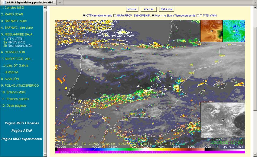
SUMMARY

     • Objectives, evolution.
     • Page entries/visualizations (using SAFNWC),
       overview, examples, product considerations:
        • Fog/low cloud
        • Icing
        • Convection “new” (preoperational)
        • Dust
        • Snow cover (experimental)
        • Entries using HRW winds
     • (Proposals/recommendations: SAFNWC 2010 Users’ Survey)
     • Conclusions and future

NWC SAF 2010 Users’ Workshop, Madrid, 26-28 April 2010      www.aemet.es   2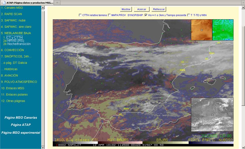
Real-time MSG/ATAP Intranet page
   • Objectives: To ease access in AEMET (not only in forecasting centres) to MSG
     real time data and products. Also useful for case archiving, training and
     product evaluation.
   • First operational version in 2005-2006 (including lists of SAFNWC products, and
     2 dedicated entries).
   • Development is focused on entries for specific applications or phenomena.
     Operational entries using SAFNWC products by now are: fog/low cloud,
     convection, aviation (icing, mountain wave) and dust.
   • Activities (page development, evaluation) are helpful to learn on product
     quality/usefulness, on better use and integration to other data, and work in
     more friendly page and visualizations or think on problems or limitations.
   • Also useful to better understand and fit to required by user or at least, to think
     on and apply more meteorological approaches in page organization and
     visualizations (example new page for convection).

                                                         Page index
                                                         (2005)

                                                                            Page index
                                                                                (2010)

NWC SAF 2010 Users’ Workshop, Madrid, 26-28 April 2010                www.aemet.es        3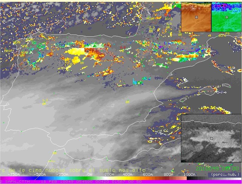
New (2010) Fog/low cloud entry: basic
                                   display/subentry (“CT+IR based”)

NWC SAF 2010 Users’ Workshop, Madrid, 26-28 April 2010   www.aemet.es      4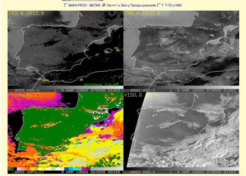
New (2010) Fog/low cloud entry: overlayed CTTH
                         minus above surface (highest) elevation

   Warm colours: CTTH is above terrain. Cold colours: below or at same level of at least 1/9 of the pixel surface points.
   Highest elevation value (at MSG resolution) is used, from a 1x1km elevation model. Mean, and lowest minus higest
                      values around the box location, are displayed in the 2 upper small windows.
NWC SAF 2010 Users’ Workshop, Madrid, 26-28 April 2010    www.aemet.es                                             5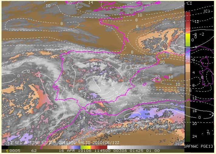
Recent example fog/low cloud entry: 18/02/2010 6z
                              (night-time)

NWC SAF 2010 Users’ Workshop, Madrid, 26-28 April 2010   www.aemet.es   6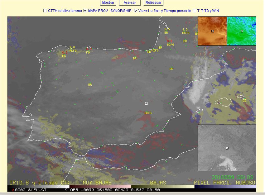
CT/CTTH Example (preoperational page) with use of
                                topography information
                 (Poster presentation “Combined use of MSG images, products and other data for
               operational forecasting at AEMET-Spain: applications to fog and in-flight aviation” .The
                               2008 EUMETSAT Meteorological Satellite Conference).

                                                         (See other examples)
NWC SAF 2010 Users’ Workshop, Madrid, 26-28 April 2010           www.aemet.es                             7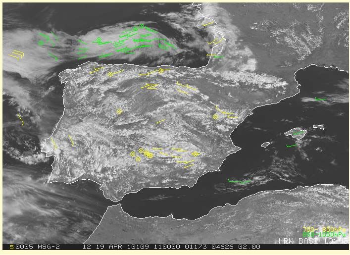
Considerations on CT and CTTH. Dawn-Dusk
              channel-based display example: 9/03/2010
   • Significant products improvement in recent versions.
   • CT: very little degradation in dawn/dusk (except in case of moving upper layer
     in multilayer cloudiness? See next slide)
   • CTTH: still “rectangular” aspect. CTTH_z around 0m not displayed?

    Of course, main satellite
    limitation: only cloud-top is
    seen!

NWC SAF 2010 Users’ Workshop, Madrid, 26-28 April 2010   www.aemet.es                 8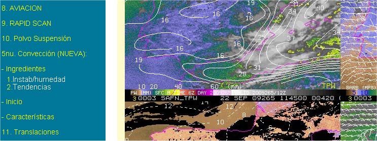
Another application of CT and CTTH: Cloud-
                              top icing Flight Level

                                                           (“Combined use of MSG images, products and other data for operational
                                                         forecasting at AEMET-Spain: applications to fog and in-flight aviation” .The
                                                                           2008 EUMETSAT Meteorological Satellite Conference).
NWC SAF 2010 Users’ Workshop, Madrid, 26-28 April 2010               www.aemet.es                                            9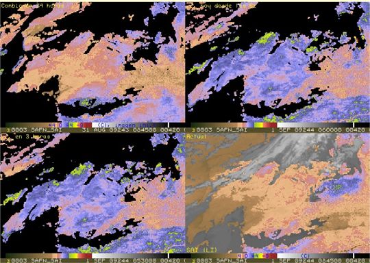
NEW SCHEME IN THE MSG PAGE FOR ACCESSING EACH “ASPECT” OF THE
                              CONVECTION (I). INGREDIENTS
                   (examples presented at ConvectionWG 2009 Workshop)
      • More meteorological approach is developed&checked: 3 sub-entries for a-priori
        conditions, initiation, and characterization, in the Convection entry (the still
        operational being more product-based approach).
      • Advantages: access purpose-oriented, eased to the forecaster. Scheme more
        suited to integrate to/with other data. Better for identification of limitations.

(Part of) experim. page with “new” conv. sub-entries                                     SAI tendencies, “new”:
                                                                                         Time&space filtering of
                                                                                         cloudiness. 24h, 6:00Æ,
                                                                                         3h, last 3 SAI+cloud

                                                               SAI tendencies, “op.”:
                                                          (6h), 3h, 1h, last SAI+cloud
 NWC SAF 2010 Users’ Workshop, Madrid, 26-28 April 2010         www.aemet.es                             10
About new PGE13 – SPhR (SAF2010) products and its application
• Some experimental products from SPhR – Physical Retrieval , including
improved SAI/TPW/LPW-like, now available at AEMET for testing. By now only
basic product display tested. Looks promising (smoothed products and changes,
SAI/LI computed for a mixed starting layer reducing diurnal variability…).
• SAI/TPW/LPW-like products could easily replace prior PGE06-07-08(-12) in
applications. Other products already provided for test: TT and guess-relative
product differences. Anyone profile-derived is in principle possible.
• Initial idea: PGE13 being physically based, product difference (to guess or prior
slots), should be easier to interpret (T/RH difference/change at any level),
finally more useful.
NWC SAF 2010 Users’ Workshop, Madrid, 26-28 April 2010 www.aemet.es 11NEW CONVECTION SCHEME (II): “MULTIPRODUCT” DISPLAY FOR CHARACTERIZATION OF EXISTING
CONVECTION
• Quick summary of satellite information + reference data (other sources).
• Integrates: NWCSAF products on convection and precipitation, channel
enhancements and combinations, radar and lightning information.
• All data are switch on/off overlays, wide number of combinations possible. Last
+ last hour (15min interval).
• Easy to use but still a few problems e.g. temporal&spatial differences on data,
display (ANIS-Java) limitations. Window interface
Default: PC+CRR+RDT+lightning
Default+EchoTop
Default+IR10.8”AEMET” enh.
PC>20% 3 classes, dim colours.
CRR 4 classes, grey (2)-white-
red (>15mm/h).
(See recent example)
NWC SAF 2010 Users’ Workshop, Madrid, 26-28 April 2010 www.aemet.es
www.aemet.es 12Entry for atmospheric dust, land example (over Africa)
16/04/2010
• Limitations in SAFNWC Dust indicator (CMa product): only qualitative,
not computed in coastal/high ground, nor nighttime over land or at
twilight…
• … But it is objective information on the phenomena and probably the
most complete from MSG, generally successful to depict the affected
areas, though not its actual extent. It is overlaid to channel /channel
combination displays (RGB Dust, Natural, HRV or HRV+VIS0.6).
At 15z.
RGB Dust
(pink
values).
+ CMa dust At 18z.
indicator RGB
(orange). +CMa.
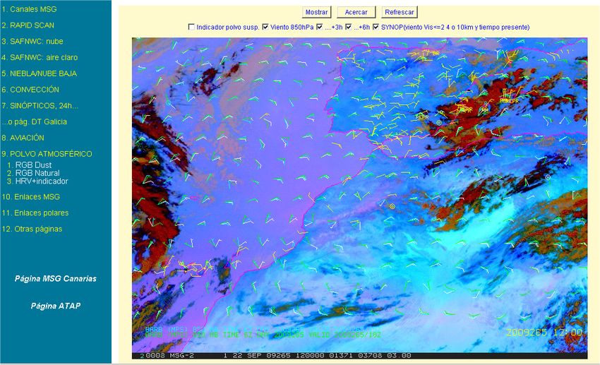
NWC SAF 2010 Users’ Workshop, Madrid, 26-28 April 2010 www.aemet.es 13Dust entry: Offshore example 22/09/2010 (Canary Islands)
Day-time RGB Natural
For these RGB-based displays 6h at 1h interval loops
available
NWC SAF 2010(for
Users’continuity, in 26-28
Workshop, Madrid, general in the page, 1h www.aemet.es
April 2010 at 15min)
14Snow cover experimental entry. Example 8-9/03/2010 (I)
• Intention: to cumulate CMa snow-covered ground pixels (daytime)
during the day until present time. To also show persisting cloud-filled /
contaminated pixels. To include ground-elevation data, and
observations. (To help the diagnostics, another subentry to last image /
last hour detailed information : RGB HRV-HRV-NIR1.6).
8/03 -15z
8/03 -9z
9/03 -9z
NWC SAF 2010 Users’ Workshop, Madrid, 26-28 April 2010 www.aemet.es 15Snow: false alarms?. + RGB HRV,NIR1.6. Example16/04/2010.
Conclusions
8/03/10 -12z
16/04/2010
10:45-
11:15z
• (Few!) false alarms are likely to occur (maybe for side-illuminated Cu cloud?),
that will persist in the day display…
• Æ so it is desirable/needed to add some information (to be studied) to the last
accumulated image in the entry, summary of temporal analysis of prior data.
NWC SAF 2010 Users’ Workshop, Madrid, 26-28 April 2010 www.aemet.es 16HRW winds used in Page applications (I)
• Aviation entry Æ Mountain wave: HRW winds (upstream!), for layers
centered at 850 and 700hPa shown, displayed on WV7.3 image.
NWC SAF 2010 Users’ Workshop, Madrid, 26-28 April 2010 www.aemet.es 17HRW winds used in Page applications (II)
• Convection entry (new) Æ C. initiation: HRW winds for layers low (700-
850hPa) and very low (>850hPa), indicators on convergence, humidity
advection, etc., related to “growing Cu” patterns found in
(background) HRV (rapid-scan cycle) image. But HRW wind information
is by now insufficient.
• Medium/high winds also displayed (Convection new Æ Characterisation).
NWC SAF 2010 Users’ Workshop, Madrid, 26-28 April 2010 www.aemet.es 18Conclusions and future
• It has been tried to explain that products could always be useful, if
well understood and adequate accessing tools (friendly, complete,
adapted to needs) are available.
• Another foreseen entry/application: precipitation.
• Of course if/when possible, the other existing entries will continue to
be upgraded (e.g. Convection adapted to PGE13)…
• … And enhanced (e.g. PGE13 to provide new parameters, as
ingredients to Convection and even Fog/low clouds entries).
• It has also been shown that development of these pages/entries is
useful to better understand needs/limitations.
• And all this work for the MSG page will certainly result very useful
when configurating the (parallel) NinJo system of meteorological
workstations, to be deployed in AEMET forecasting centres in next
years.
NWC SAF 2010 Users’ Workshop, Madrid, 26-28 April 2010 www.aemet.es 19CTTH (CT) examples (CTTH_z=0m, Cu cloudiness, disipating Fog/St)
(preoperational page, presentation “Combined use of MSG images, products and other
data for operational forecasting at AEMET-Spain: applications to fog and in-flight aviation”
.The 2008 EUMETSAT Meteorological Satellite Conference).
NWC SAF 2010 Users’ Workshop, Madrid, 26-28 April 2010 www.aemet.es 20Recent example: 9/03/2010 6z (day-time). NWC SAF 2010 Users’ Workshop, Madrid, 26-28 April 2010 www.aemet.es 21
Recent example of multiproduct display: 16/04/2010
    15z (basic, +Echotop, IR10.8 with ConvWG enhancement)

NWC SAF 2010 Users’ Workshop, Madrid, 26-28 April 2010   www.aemet.es   22
Proposals/recommendations: products
• Remarkable effort in objective validation. But, usefulness? “Usability
indicator” could be added to appended Q.I. in accordance to
“meteorological conditions” (e.g. re-evaluate criteria for final
weighted QI for HRW winds).
• More cloud properties: liquid/solid, Reff, liquid path/content (Æ icing
and convection characteristics)
• “Broken cloudiness” CT class : improve properties determination from
use of HRV. Focus computation of “detailed” HRW wind in that class or
allow it for specific CT classes.
• Include “Convection Initiation” or “Ligthning initiation” products, or its
elements in existing e.g. RDT.
• Continuing the (quite successful) experience on temporal analysis in
cloud products at twilight: consider rapid-scan to improve cloud
analysis (basic for most products), and HRW computations.
• Many more specific product by product remarks (2010 Users’ Survey).
NWC SAF 2010 Users’ Workshop, Madrid, 26-28 April 2010 www.aemet.es 23Proposals/recommendations: general
• To ensure a soft transition MSG to MTP (e.g. PGE13 or cloud products).
• To revisit the whole SAFNWC strategy: based on too specific products.
Revise cooperation and data integration (PPS/MSG, SAFNWC/MPEF,
SAFNWC/other SAFs as NWPSAF). Objective: complete “analyzing
system”...
• … And focal point or excellence centre on use of satellite for use of
satellite (and other) data on weather watch and support to
nowcasting…
• … With wider implication of users (it is, as previous points, matter to
be discussed).
NWC SAF 2010 Users’ Workshop, Madrid, 26-28 April 2010 www.aemet.es 24Conclusions and future
• It has been tried to explain that products could always be useful, if
well understood and adequate accessing tools (friendly, complete,
adapted to needs) are available.
• Another foreseen entry/application: precipitation.
• Of course if/when possible, the other existing entries will continue to
be upgraded (e.g. Convection adapted to PGE13)…
• … And enhanced (e.g. PGE13 to provide new parameters, as
ingredients to Convection and even Fog/low clouds entries).
• It has also been shown that development of these pages/entries is
useful to better understand needs/limitations.
• And all this work for the MSG page will certainly result very useful
when configurating the (parallel) NinJo system of meteorological
workstations, to be deployed in AEMET forecasting centres in next
years.
NWC SAF 2010 Users’ Workshop, Madrid, 26-28 April 2010 www.aemet.es 25You can also read