Sanitary Survey - classification zone - Car y Mor 2021 - Carcinus Ltd
←
→
Page content transcription
If your browser does not render page correctly, please read the page content below
Sanitary Survey - classification zone
Car y Mor – 2021
Document No. – J0591/21/02/02
Carcinus Ltd, Wessex House, Upper Market Street, Eastleigh, Hampshire, SO50 9FD.
Tel. 023 8129 0095
https://www.carcinus.co.uk/
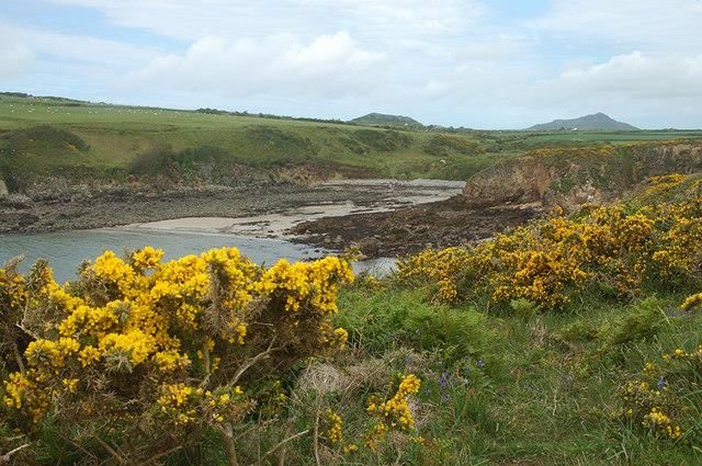
Cover image: Porthllisky Bay from the PCP. Image © Row17, CC-BY-SA 2.0.
Page | i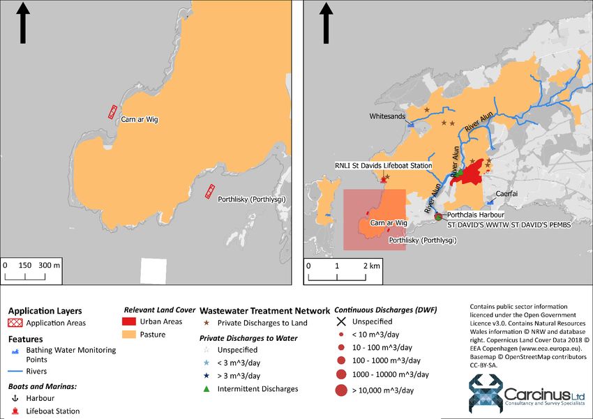
Carcinus Ltd – Document Control Sheet
 Client                               Food Standards Agency (FSA)

 Project Title                        New zone classification – sanitary survey

 Document Title                       Sanitary Survey - Classification Zone Assessment - Car y Mor

 Document Number                      J0591/21/02/02

 Revision                             2.0

 Date                                 26 March 2021

Revisions
 Revision No.      Date                          Comment

 1.0               11 February 2021              Draft for FSA approval.

 2.0               26 March 2021                 Final Document

Document QA and Approval
                              Name                             Role                              Date

 Author                       Joshua Baker                     Freshwater and Marine             26 March 2021
                                                               Ecologist

 Checked                      Matthew Crabb                    Director                          26 March 2021

 Approved                     Matthew Crabb                    Director                          26 March 2021

This report was produced by Carcinus Ltd. on behalf of the Food Standards Agency (FSA) for the
purposes of providing a sanitary survey for the specific Bivalve Mollusc classification zone (BMCZ)
application as detailed in this report. Every effort has been made to ensure the information
contained within is as complete and valid as possible at the time of writing. It should be noted that
additional information may have existed at the time of publication of this report that was not
available, not identified or has subsequently been published after the date of this report. Carcinus
Ltd accepts no liability for any costs, losses or liabilities arising from the reliance upon or use of the
contents of this report other than by its client.

Dissemination
Food Standards Agency, Pembrokeshire County Council. The report is publicly available via the
Carcinus Ltd. website.

Recommended Bibliographic Citation:
Carcinus Ltd., 2021. Sanitary survey of the Car y Mor aquaculture site. Carcinus report on behalf of
the Food Standards Agency, to demonstrate compliance with the requirements for classification of
bivalve mollusc production areas in England and Wales under retained EU Law Regulation (EU)
2019/627.

Page | ii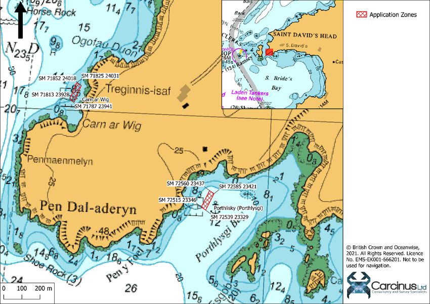
Contents
1      Introduction .................................................................................................................................... 1
    1.1        Legislative Requirement ......................................................................................................... 1
    1.2        Scope of assessments ............................................................................................................. 1
2      Application and Fishery................................................................................................................... 2
3      Sources of Faecal Contamination ................................................................................................... 3
    3.1        Freshwater inputs ................................................................................................................... 5
    3.2        Sewage Discharges .................................................................................................................. 5
       3.2.1          Continuous Discharges .................................................................................................... 5
       3.2.2          Intermittent Discharges .................................................................................................. 5
       3.2.3          Private Discharges ........................................................................................................... 6
    3.3        Boats and Marinas .................................................................................................................. 6
    3.4        Agricultural Sources ................................................................................................................ 6
    3.5        Wildlife .................................................................................................................................... 7
    3.6        Other Sources of Contamination ............................................................................................ 7
4      Existing Classifications and Monitoring History .............................................................................. 7
5      Hydrodynamics/Water Circulation ................................................................................................. 8
6      Other Considerations ...................................................................................................................... 8
7      Recommendations for a RMP and Classification Zone ................................................................... 9
    7.1        Provisional Classification Zone ................................................................................................ 9
    7.2        Representative Monitoring Point (RMP) ................................................................................ 9
    7.3        Classification Species .............................................................................................................. 9
       7.3.1          Criteria for Sampling ....................................................................................................... 9
8      Recommendations for a Shoreline Survey .................................................................................... 12
9      References .................................................................................................................................... 12
About Carcinus Ltd ................................................................................................................................ 13
Contact Us ............................................................................................................................................. 13
Environmental Consultancy .................................................................................................................. 13
Ecological and Geophysical Surveys...................................................................................................... 13
Our Vision.............................................................................................................................................. 13

Page | iii
List of figures
Figure 2.1 Application zone boundaries. ................................................................................................ 3
Figure 3.1: Potential sources of faecal and chemical contamination to the application zone. .............. 4
Figure 7.1: Location of RMP within application zone. .......................................................................... 10

List of tables
Table 2.1 Coordinates delineating the Application Zones. ..................................................................... 2
Table 3.1: Details of Continuous Discharges within the application zone. ............................................. 5
Table 3.2: Details of intermittent discharges within the application zone. ............................................ 6
Table 7.1: Provisional Sampling Plan for the Carn ar Wig CZ. ............................................................... 10
Table 7.2: Provisional Sampling Plan for the Porthllisky CZ. ................................................................. 11

Page | iv

1 Introduction
This report was produced by Carcinus Ltd. on behalf of the Food Standards Agency (FSA) for the
purposes of providing a sanitary survey of classification zone, desktop assessment and
recommendation on the need to conduct a shoreline assessment and/or bacteriological survey for
the proposed Production area within Car y Mor, Pembrokeshire, for the harvesting of farmed native
oysters (Ostrea edulis), mussels (Mytilus edulis) and King scallops (Pecten maximus).

1.1 Legislative Requirement
Bivalve molluscs, such as mussels, clams and oysters, are filter feeding organisms that filter the
water in which they live to feed on microorganisms. This feeding behaviour increases their ability to
accumulate and retain microorganisms, including those that are pathogenic to humans, and other
chemical contaminants in the water column. The safety of bivalves harvested for human
consumption is therefore strongly influenced by the quality of water in which they have grown.
Sources of microbiological contamination from a variety of sources, including human and/or animal
origin, can affect Bivalve Mollusc Production Areas (BMPAs), the suitability of shellfish harvested
from such areas for human consumption and the post-harvesting processes necessary to make Live
Bivalve Molluscs (LBMs) safe.

EC Regulation 2019/627 sets out specific requirements for the classification of new Bivalve Mollusc
Classification Zones (BMCZs), including the requirements for a sanitary survey to be conducted. The
primary element of a sanitary survey for new areas is a desktop assessment, which will determine a
sampling plan to be initiated at a new specific LBM bed with a view to classification. The proposed
sampling programme and the sampling locations arising from the desktop assessment are based on
the examination of publicly available information on the geographical and hydrological
characteristics of the area and potential sources of pollution, as well as any existing sanitary surveys
and/or E. coli data relating to the area (if available) from Official Control monitoring, or any
neighbouring classified production areas (where relevant). Sample numbers, sampling points and
sampling frequency ensure the results of the analysis are as representative as possible for the area
considered. Thus, the sanitary survey determines a Representative Monitoring Point (RMP) to inform
a provisional sampling plan to facilitate the classification of a new production area/bed (Note, the
RMP must represent the worst-case scenario of contamination within the production area to be
classified); it also confirms the provisional boundary of the area/bed requested to be classified.
Although the boundary of the production area or bed is suggested in the harvester’s application, it is
necessary to define the boundary co-ordinates of the water body based on the available evidence to
ensure any identified sources of pollution are considered. The sanitary survey also considers
whether there is a need for a shoreline and/or bacteriological survey to be conducted before the
sampling plan is finalised.

In England and Wales the Central Competent Authority (CCA) under retained EU Law Regulation (EU)
2019/627 is the FSA. Carcinus are contracted to undertake sanitary surveys for new BMCZs in
England and Wales on behalf of the FSA. These assessments are to demonstrate compliance with the
requirements stated in Article 56 of retained EU Law Regulation (EU) 2019/627.

1.2 Scope of assessments
A desktop assessment is the first stage in the sanitary survey process relating to retained EU Law
Regulation (EU) 2019/627, and is used to provide a basic assessment of contamination risks to the

Page | 1
shellfishery as well as a provisional sampling plan that identifies a Representative Monitoring Point
(RMP), sampling frequency, sampling depth, tolerance, species to be sampled and the provisional
production area boundaries. The desktop survey focusses on bacterial contamination sources
(primarily from faecal origins) and the associated loads of the faecal indicator organism E. coli and
does not assess chemical contamination, or the risks associated with biotoxins. The assessment also
determines whether the area requires a shoreline and/or a bacteriological survey before the sanitary
survey can be finalised. The procedure followed is not appropriate to consideration of applications
within marinas and docks.

2 Application and Fishery
An application for the classification areas in the waters near St Davids, Pembrokeshire was received
from Pembrokeshire County Council – Local Authority (LA). The application was validated by the FSA
and passed to Carcinus for the purposes of undertaking a sanitary survey desktop assessment. The
requested application zones are bounded by the coordinates in Table 2.1. The location of the
application zones off the Pembrokeshire coast can be seen in Figure 2.1. Both application zones are
relatively small, approximately 30 m by 100 m.
Table 2.1 Coordinates delineating the Application Zones.

                         Point reference          NGR (OSGB     WGS 1984,              WGS 1984,
         Site                                        1936,      EPSG:4326              EPSG:4326
                                                  EPSG:27000)    Latitude               Longitude
                                  A              SM 7256 2344   51.863036°             -5.304682°
   Porthllisky                    B              SM 7259 2342   51.862895°             -5.304309°
 (Porthlysgi) Bay                 C              SM 7254 2333   51.862058°             -5.304918°
                                  D              SM 7252 2335   51.862199°             -5.305277°
                                  A              SM 7183 2403   51.868074°             -5.315736°
                                  B              SM 7185 2402   51.867964°             -5.315337°
    Carn ar Wig
                                  C              SM 7181 2393   51.867141°             -5.315830°
                                  D              SM 7179 2394   51.867242°             -5.316227°

There are no additional classification zones within the near vicinity of the application zones; the
closest is at Milford Haven which is approximately 25 km south – east of this zone.

The application specifies harvesting of farmed mussels, native oysters and king scallops. The mussels
will be grown on rope, and harvested August – May each year. The native oysters will be grown in
lanterns and cages, and harvested August – April each year. The scallops will also be grown in
lanterns and will be harvested from September – April each year, once at marketable size. The
applicant intends to commence harvesting in 2022 and indicates that wild mussels are currently on
the gear and spat will be collected in Spring 2021. Native oysters are already being grown, and at the
time of this survey (February 2021), are currently at 15 g. Wild scallops are believed to be already
present in the area. The application does not indicate the expected output from the fishery,
although will likely be limited by the size of the application zones.

Page | 2
Figure 2.1 Application zone boundaries. 3 Sources of Faecal Contamination A sanitary survey desktop assessment has been conducted to identify potential sources of faecal contamination to the application areas. Figure 3.1 presents the location of potentially significant sources of contamination identified as part of this study. Active consented discharges have been identified through the interrogation of Natural Resources Wales (NRW) permit database1 (December 2020). No existing sanitary surveys (or similar) covering the waters around the application areas were available to the authors of this review. 1 NRW permit data have not been validated and as such the accuracy of such information cannot be guaranteed. Page | 3
Figure 3.1: Potential sources of faecal and chemical contamination to the application zone.

Page | 4
3.1 Freshwater inputs
Freshwater inputs require consideration as part of the assessment, as they act to carry
contamination resulting from runoff, urban diffuse and point source pollution and other rural diffuse
sources. During the winter, increased rainfall is likely to result in increased levels of runoff and a
subsequent increase in bacterial loading carried into coastal waters. Bacterial loading is typically
highest during periods of heavy rain occurring following a dry period.

The main watercourse in the area is the Afon Alun, which passes through the main urban area of St
Davids and discharges to Porthclais Bay, approximately 1.7 km east of the application area. Whilst
this river will carry diffuse pollution (such as agricultural / urban surface runoff (see Sections 3.4 and
3.63.5)) from the upper reaches of the catchment out into coastal waters, the overall impact of this
watercourse is expected to be minor, given the limited hydrodynamic connectivity with the
application area. Any impact will be seen to a greater extent at the Porthllisky site than at the Carn
ar Wig site, as the latter is farther round the headland. Additionally, here is an unnamed stream that
drains to Porthllisky Bay which may carry some additional contamination to the Porthllisky site and
the RMP for this zone should take this into account. There are no watercourses draining to the Carn
ar Wig site, and so the RMP location for this zone does not need to take them into account.

3.2 Sewage Discharges
3.2.1 Continuous Discharges
There is a single continuous discharge contained within the relatively small catchment draining to
the application zone. Details of this discharge is presented in Table 3.1 and its position within the
catchment is shown in Figure 3.1.
Table 3.1: Details of Continuous Discharges within the application zone.

 Name                     Dry Weather           Treatment Type             NGR (OSGB 1936,   Receiving
                          Flow (m3/day)                                    EPSG 27000)       Environment
 St Davids                                      Biological                                   Coastal Waters at
                                 987                                        SM 74303 23849
 WWTW                                           Filtration                                   Porthclais

The continuous discharge from St Davids WWTW is situated in Porthclais Bay, more than 1.7 km
(straight line) from the Porthllisky application zone, and even further from the Carn ar Wig zone. As
such, the risk it poses is low given the lack of connectivity, even though it only employs secondary
treatment.

3.2.2 Intermittent Discharges
Intermittent discharges, comprising Combined Storm Overflows (CSOs), storm tank overflows and
pumping station emergency overflows have the potential to significantly affect local water quality
and subsequently the management of shellfish hygiene within BMCZs. Spill events either occur
during periods of wet weather when the sewers are inundated with surface water and infiltration of
groundwater, or in the event of an emergency failure of a plant/equipment. Monthly classification
sampling cannot normally reliably characterise the impacts from these spills as they occur
sporadically and/or infrequently. Whilst some discharges are screened to remove sewage debris
prior to discharge, such screening is unlikely to significantly reduce faecal bacterial loading. These
discharges therefore often spill raw/untreated effluent with high faecal coliform concentrations (7.2
x106 CFU/100 ml, Kay et al., 2008).

Page | 5
There are only four intermittent discharges in the land draining to the application zone. Details of
these discharges, including any treatment in place, are presented in Table 3.2. The positions of these
discharges are shown in Figure 3.1.
Table 3.2: Details of intermittent discharges within the application zone.
Treatment Type (if NGR (OSGB 1936,
Name Receiving Environment
applicable) EPSG 27000)
Pebbles St Davids
Screening SM 75060 25420 River Alun
SWO
Pit St Davids SWO Screening SM 74930 25350 River Alun
Coastal Waters at Porth
St Davids WWTW Screening SM 74303 23849
Clais
Vicarage Road St
Screening SM 75080 25460 River Alun
Davids SWO
Three of these discharges drain to the River Alun, that ultimately drains out into Porthclais Bay
(where the other discharge is located). Even though all only employ screening, and so are likely to
result in high E. coli levels following spill events, there is limited hydrodynamic connectivity with the
application zones. As such, the placement of RMP(s) does not need to take these discharges into
account.
3.2.3 Private Discharges
In addition to the water company owned discharges, there are several other privately-owned
discharges throughout the catchment (Figure 3.1). However, as all are located in the upper reaches
of the catchment, they pose little contamination risk to the application zones.
3.3 Boats and Marinas
Whilst the coastal waters off Pembrokeshire are popular with recreational boaters, most of this
activity is focussed around the Milford Haven waterway (Visit Pembrokeshire, 2021). Analysis of
recent (captured in 2020) satellite imagery indicated that there is a single small harbour at the head
of Porthclais Bay, although this has no facilities for visiting vessels. Recreational vessels of sufficient
size to contain on-board toilets are liable to make overboard discharges from time to time,
particularly when moored overnight or when navigating through an area. Contamination from
recreational vessels represents significant source of contamination at certain times of the year (May
to September).
Merchant shipping vessels are prohibited from making overboard discharges within three nautical
miles of land2, meaning that no impact on the application zone is expected from vessels transiting
past the Exe estuary. Therefore, inputs from boats may contribute to the overall faecal loading
within the area and contribute to faecal loadings to the Application Area, however, this contribution
is considered to be minimal and also cannot be reliably captured by an RMP.
3.4 Agricultural Sources
The main route through which diffuse sources of agricultural faecal contamination enters waterways
(and subsequently BMCZs) is runoff during periods of wet weather. Faecal loading through this
source is typically highest during winter months when rainfall and river flows are at their highest
2
The Merchant Shipping (Prevention of Pollution by Sewage and Garbage from Ships) Regulations 2008.
Page | 6levels. However, high loadings are possible at any time of year during significant rainfall events, particularly following a period of prolonged dry weather. Land cover maps issued in 2018 indicate that a significant proportion of the catchment is given over to pasture (Figure 3.1), including the land immediately adjacent to the shorelines where each application zone is situated. Land runoff from livestock waste therefore represents a potentially significant source of contamination to the application zone, particularly following high rainfall events that follow periods of dry weather. Livestock numbers will be greatest in Spring, and lowest in Autumn when animals are sent to market. Given that pasture is located immediately adjacent to the application zones, any RMPs should tend to be placed on the shoreward side of any classification zone. 3.5 Wildlife The waters and coastline around the application area contain a variety of habitats that support many important wildlife species. As such, the area is conferred protection under a variety of national and international designations, including as a Special Area of Conservation (SAC), Site of Special Scientific Interest (SSSI) and National Nature Reserve. Ramsey Island, 1 km to the west of the application zones, supports several important waterbird species such as Guillemots, Razorbills, Fulmars and Kittiwakes. When foraging for food, these species may defecate directly on shellfish waters, which therefore represents a potentially significant source of pollution. However, the precise distribution of these species is driven by their prey, and so it is difficult to define an RMP that accurately captures this source of pollution, given the spatial and temporal variability of the avian population. Large numbers of grey seals forage in the waters around the application zone, with a minimum of 2688 individuals documented between 1992 and 2016 (Langley et al., 2020), with highest numbers around the application site occurring in winter months (Westcott & Stringell, 2004). The foraging behaviour and associated faecal pollution of seals around the application zone is spatially and temporally unpredictable, and so it is difficult to define an RMP that will effectively capture the influence. 3.6 Other Sources of Contamination Urban fabric within the catchment is concentrated around the city of St Davids, with very few other built-up areas. Runoff from St Davids, through utility misconnections and dog fouling, will be carried into coastal waters via the Afon Alun, and is unlikely to pose a significant risk to the application area due to a lack of hydraulic connectivity. The Pembrokeshire Coastal path runs past both application zones and is likely to be popular with dog walkers. Some contamination of nearshore coastal waters by dog fouling may therefore occur, though the effect is likely to be minimal. 4 Existing Classifications and Monitoring History The application zones are not in the vicinity of any other classification zones. The closest is near Milford Haven, over 25 km away, and as such the monitoring results from that zone are not indicators of potential contamination of this shellfishery. The status of EC bathing waters near the application zone are also of relevance to this assessment. There are two EC Bathing Water Quality Monitoring Points relatively near to the application zones (Figure 3.1). All have been consistently classified as excellent, with low levels of faecal coliforms Page | 7
(including E. coli) recorded in samples collected for classification purposes under EC Bathing Waters
Directive (2006/7/EC). It should be noted that all three points are located outside the main estuary
and that bathing water sampling only occurs during the summer period (May to September
inclusive) and, therefore, may not represent the potential for increased faecal loading during periods
of increased rainfall during winter months. However, bathing water results do provide an indication
of water quality in the area during the bathing water season.

5 Hydrodynamics/Water Circulation
The application zones are located on the western coast of Wales, near Ramsey Island. Tidal streams
are likely to be the dominating force of water circulation under most conditions. Tidal streams within
the vicinity of the application zone are best characterised by the following data:

    •   The most relevant tidal prediction for the application zones is located at Ramsey Sound
        (51° 53’ N, 5° 19’ W, UKHO Total Tide (0492 – Ramsey Sound). Tidal ranges for this location
        are as follows (all referenced to Chart Datum):
            o Mean Spring Range: 4.4 m; and
            o Mean Neap Range: 1.7 m.

Tidal currents by the Carn ar Wig site run on an approximate North-South axis, whereas those near
Porthllisky run on a more east-west axis. Tidal currents in the area can be very strong, reaching up to
18 kn over The Bitches Rocks, adjacent to Ramsey Island (Voyages of Discovery, 2021). Any
contamination could therefore be transported a significant distance during spring tides.

6 Other Considerations
The application zones are not located within a current Shellfish Disease Control Area, the boundaries
of the Notice of Confirmed Designation for Anglesey Caernarfonshire for Bonamia ostreae under The
Aquatic Animal Health (England and Wales) Regulations, 2009 (Cefas, 2016) extend to approximately
25 km from the application zone. Under this notice, the movement of bivalve mollusc species into,
out of or within this area is prohibited, except for the purposes as defined under the notice,
including that “the species… may be taken from the area for direct human consumption, and must
not be re‐immersed”.

Page | 8
7 Recommendations for a RMP and Classification Zone 7.1 Provisional Classification Zone The application zones to be used as a production area for mussels, native oysters and scallops are delineated by the coordinates outlined in Table 2.1. These coordinates define two areas on the west coast of Wales, either side of the headland opposite Ramsey Island. It is recommended that the a separate classification zone be created for each area, and the boundaries remain the same as defined in the application. 7.2 Representative Monitoring Point (RMP) The location of the RMP has been informed based on the identified contamination sources described within this assessment, likely connectivity with the provisional classification zone outlined above, seasonality of inputs and faecal contamination loadings. The main source of contamination to these zones is anticipated to be surface runoff from areas of pasture laying immediately adjacent to the coast. Some diffuse background contamination may also be carried from the two main watercourses in the area, the Afon Alun and an unnamed stream that drains into Porthllisky Bay. There is little hydrodynamic connectivity between the discharges in the catchment and the application zones, and as such the contamination from these sources is only likely to contribute to background levels. Given the small size of each zone, the choices for RMP location are limited. It is our recommendation that the RMP for the Carn ar Wig zone be located at the mid-point of the longest shoreline side of the zone (the line connecting points B and C in Table 2.1), and that the RMP for the Porthllisky zone be located at the mid-point of the shorter shoreline side of the zone (the line connecting points A and B in Table 2.1) (Figure 7.1). This will best capture contamination from the various sources. 7.3 Classification Species A report commissioned by the FSA (Cefas, 2014) to examine the suitability of other shellfish species as indicator species has been reviewed to determine the suitability of indicators for classification purposes. The recommendations for indicator species in relation to E. coli accumulation are generally limited by data availability and recommendations can only be made where sufficient data are available to compare E. coli accumulation and clearance in two or more species. The application is for the harvesting of farmed mussels (Mytilus edulis), native oysters (Ostrea edulis) and King Scallops (Pecten maximus). The acquisition of individuals from each species is not anticipated to be problematic as the RMP location is situated within the boundary of each zone. The Cefas (2014) report states that Mytilus spp. can be used to represent O. edulis and vice versa, but that the use indicator species is not appropriate for P. maximus CZs. However, as this survey has identified few contaminating influences to the zones, it is probable that a Class A classification could be achieved. As Class A shellfish can be consumed directly without further treatment, we recommend taking samples from each of the three harvested species in the same location. Given any contaminating influences are likely to be shoreline / freshwater in origin, samples should be taken from the highest possible point in the water column where a given species is cultured / grown, as contamination will be higher further up in the water column owning to the buoyant nature of freshwater inputs into the marine environment prior to full mixing within the water column. 7.3.1 Criteria for Sampling The following criteria should be applied to sampling at the designated RMPs: Page | 9
•    Each sample should comprise only those individuals of harvestable / marketable size; and
    •    Sample collection of each species to be undertaken by boat within a tolerance of 10 m from
         the RMP.

Figure 7.1: Location of RMP within application zone.

The RMP, sampling plan and provisional Classification Zone boundary for each CZ is presented in
Table 7.1 and Table 7.2.

Note - All coordinates in WGS1984, EPSG: 4326 are in dd.dddddd° format and those presented in
OSGB 1936, EPSG:27700: are presented as Eastings and Northings (m).
Table 7.1: Provisional Sampling Plan for the Carn ar Wig CZ.

 Production area                                  Car y Mor
 Provisional Classification Zone                  Carn ar Wig
 RMP name(s)                                      Carn ar Wig (M. sp);
                                                  Carn ar Wig (O. ed); and
                                                  Carn ar Wig (P. ma)
 RMP                                              Latitude / Longitude (WGS 1984, EPSG:4326):
                                                  51.867540° N, 5.315576° W
                                                  Ordnance Survey National Grid (OSGB 1936, EPSG:27000)
                                                  171833 E, 223972 N
 Classification species                           M. edulis;
                                                  O. edulis; and
                                                  P. maximus
 Sampling species                                 M. edulis;
                                                  O. edulis; and

Page | 10
P. maximus
Sampling depth At least 1 m below surface for all species
Collection method Via boat
Sampling tolerance 10 m(around RMP)
Sampling frequency Monthly – year round
Provisional Classification Zone Delineated by lines between these points (WGS 1984, EPSG
Boundaries: 4326):
51.868074° N, 5.315736° W
51.867964° N, 5.315337° W
51.867141° N, 5.315830° W
51.867242° N, 5.316227° W
Delineated by lines between these points (OSGB 1936
EPSG:27000):
171825 E, 224031 N
171852 E, 224018 N
171813 E, 223928 N
171787 E, 223941 N
Notes None
Table 7.2: Provisional Sampling Plan for the Porthllisky CZ.
Production area Car y Mor
Provisional Classification Zone Porthllisky (Porthlysgi)
RMP name(s) Porthllisky (M. sp);
Porthllisky (O. ed); and
Porthllisky (P. ma)
RMP Latitude / Longitude (WGS 1984, EPSG:4326):
51.862933° N, 5.304457° W
Ordnance Survey National Grid (OSGB 1936, EPSG:27000)
172575 E, 223425 N
Classification species M. edulis;
O. edulis; and
P. maximus
Sampling species M. edulis;
O. edulis; and
P. maximus
Sampling depth At least 1 m below surface for all species
Collection method Via boat
Sampling tolerance 10 m (around RMP)
Sampling frequency Monthly – year round
Provisional Classification Zone Delineated by lines between these points (WGS 1984, EPSG
Boundaries: 4326):
51.863036° N, 5.304682° W
51.862895° N, 5.304309° W
51.862058° N, 5.304918° W
51.862199° N, 5.305277° W
Delineated by lines between these points (OSGB 1936
EPSG:27000):
Page | 11172560 E, 223437 N
172585 E, 223421 N
172539 E, 223329 N
172515 E, 223346 N
Notes None
8 Recommendations for a Shoreline Survey
Both proposed classification zones are of a relatively small size (100 m x 30 m), which limits the
placement of the RMP. Both zones are in a rural area of west Wales, with limited pathways for
connectivity with up-catchment pollution sources. Most contamination will originate through
surface run-off from areas of pasture, although even this is not expected to cause significant
pollution of the shellfishery.
It is, therefore, our recommendation that, in this case, physical assessment of the zone to confirm
existing sources of contamination or identify any unknown sources, in the form of a shoreline
survey, is not considered of significant value. Whilst there is no existing monitoring data, a shoreline
survey would not provide any evidence that will not be produced through on-going monitoring for
classification purposes. The assessment has identified sufficient information to enable the
placement of the RMP in a location representative of faecal contamination sources within the area,
particularly as the small size of the zone limits the possible locations for any RMP.
9 References
Cefas, 2014. A critical review of the current evidence for the potential use of indicator species to
classify UK Shellfish Production Areas. Final Report. FS512006. Centre for Environment, Fisheries and
Aquaculture Science, Weymouth UK.
Cefas, 2016. Notice of Confirmed Designation for Pembrookshire for Bonamia ostreae. Designation
Number: CD 05/2015 v.2.
Langley, I., Rosas da Costa Oliver, T., Hiby, L. et al., 2020. Site use and connectivity of female grey
seals (Halichoerus grypus) around Wales. Mar Biol 167, 86. https://doi.org/10.1007/s00227-020-
03697-8.
Visit Pembrokeshire, 2021. Sailing in Pembrokeshire. Available [online] at:
https://www.visitpembrokeshire.com/activities-adventure/sailing. Accessed February 2021.
Voyages of Discovery, 2021. The Bitches Rocks. Available [online] at:
https://www.ramseyisland.co.uk/the-islands/the-bitches-rocks/. Accessed February 2021.
Westcott, S.M. & Stringell, T.B., 2004. Grey seal distribution and abundance in North Wales, 2002 –
2003. Marine Monitoring Report No: 13. Countryside Council for Wales.
Page | 12About Carcinus Ltd Environmental Consultancy
Carcinus Ltd is a leading provider of aquatic Carcinus provides environmental consultancy services for
environmental consultancy and survey services in the UK. both freshwater and marine environments. Our
freshwater and marine environmental consultants
Carcinus was established in 2016 by its directors after provide services that include scoping studies,
over 30 years combined experience of working within the Environmental Impact Assessment (EIA) for ecological
marine and freshwater environment sector. From our and human receptors, Habitats Regulations Appraisal
base in Southampton, we provide environmental (HRA), Water Framework Directive (WFD) assessments,
consultancy advice and support as well as ecological, project management, licensing and consent support, pre-
topographic and hydrographic survey services to clients dredge sediment assessments and options appraisal,
throughout the UK and overseas. stakeholder and regulator engagement, survey design
Our clients operate in a range of industry sectors and management and site selection and feasibility
including civil engineering and construction, ports and studies.
harbours, new and existing nuclear power, renewable
energy (including offshore wind, tidal energy and wave Ecological and Geophysical
energy), public sector, government, NGOs, transport and
water. Surveys
Our aim is to offer professional, high quality and robust
Carcinus delivers ecology surveys in both marine and
solutions to our clients, using the latest techniques,
freshwater environments. Our staff are experienced in
innovation and recognised best practice.
the design and implementation of ecological surveys,
including marine subtidal and intertidal fish ecology and
Contact Us benthic ecology, freshwater fisheries, macro invertebrate
sampling, macrophytes, marine mammals, birds, habitat
Carcinus Ltd mapping, River Habitat Surveys (RHS), phase 1 habitat
surveys, catchment studies, water quality and sediment
Wessex House sampling and analysis, ichthyoplankton, zooplankton and
Upper Market Street phytoplankton.
Eastleigh In addition, we provide aerial, topographic, bathymetric
and laser scan surveys for nearshore, coastal and riverine
Hampshire
environments.
SO50 9FD
Tel. 023 8129 0095 Our Vision
Email. enquiries@carcinus.co.uk
Web. https://www.carcinus.co.uk “To be a dependable partner to our clients,
providing robust and reliable environmental
advice, services and support, enabling them to
achieve project aims whilst taking due care of the
sensitivity of the environment”
Page | 13You can also read