Scarborough 2002 - An Audit of Scarborough Today A Review of Physical and Economic Resources - JTP
←
→
Page content transcription
If your browser does not render page correctly, please read the page content below
Scarborough 2002

               A Review of Physical and
                   Economic Resources

An Audit of Scarborough Today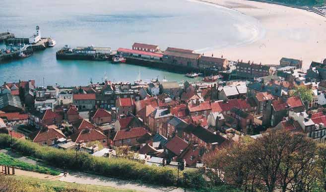
1                       2

      3                             4                            5

                                                                             9

6            7                               8

    Scarborough’s Urban Renaissance
    Publications
    The Scarborough Urban Renaissance programme was launched in February 2002 with
    an explanatory Broadsheet (1), followed by an intensive period of information gathering and community
    ‘animation’, working towards a large scale Community Planning Weekend for which invitations (2) were
    distributed in March. Immediately following the Weekend, summary broadsheets of both the
    proceedings (3) and draft Public Space Strategy (4) were issued, followed in mid-June by a 12 page
    full colour summary of the Vision (5), which was distributed to the whole town, through the local free
    newspaper.

    In August 2002, four companion reports were published: Scarborough 2002, an audit of the town today
    (6), A Diary of Contact, a diary of community animation and cultural audit (7), A Vision for Scarborough,
    the full report of the Community Planning Weekend (8), and The Scarborough Renaissance Charter (9).
Scarborough 2002

     Scarborough 2002
     An Audit of Scarborough Today

     This report has been produced by John Thompson and Partners, working as
     part of Yorkshire Forward’s Urban Renaissance Panel. It presents a review of
     the physical and economic resources of the town, carried out between
     January and April 2002.

     Yorkshire Forward
     Victoria House
     Victoria Place
     Leeds LS11 5AE
     T: 0113 394 9600
     F: 0113 394 9624
     e: alan.simpson@yorkshire-forward.com

     Scarborough Borough Council
     Town Hall
     St Nicholas Street
     Scarborough YO11 2HG
     T: 01723 232323
     F: 01723 503826
     e: dts@scarborough.gov.uk

JT   John Thompson & Partners
     70 Cowcross Street
     London EC1M 6 EJ
     T: 020 7251 5135
     F: 020 7251 5136
     e: jtplon@jtp.co.uk

     West 8
     Wilhelminakade 68
     Postbus 24326
     Rotterdam
     Netherlands
     T: 00 31 10 485 5801
     F: 00 31 10 4856323
     e: a.geuze@west8.nl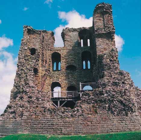
Scarborough 2002

ii
                        Scarborough 2002
                        An Audit of Scarborough Today

                        Urban Renaissance Panel
                        Adriaan Geuze, West 8
                        Alan Simpson, Director of Urban Renaissance, Yorkshire Forward
                        John Thompson, Chairman, John Thompson & Partners

                        Other team members

                        Yorkshire Forward: Narendra Bajaria, Carrie Smith

                        John Thompson & Partners: Marcus Adams, Joanna Allen, James Armitage, Jeff Austin,
                        Charles Campion, Jonathan Davis, Paul Drew, Sue Hargreaves, David Harrison,
                        Eric Holding, Fred London, Clara Overes, Debbie Radcliffe, Constanze Roth,
                        Bob Young, Andreas von Zadow

                        West 8: Martin Biewenga, Riette Bosch, Helen Day,
                        Marco van der Pluym

                        Acknowledgments

                        Yorkshire Forward would like to thank everyone who participated in the Vision for
                        Scarborough Community Planning process, the people of Scarborough, the staff at the Spa
                        Complex and Rounders, the Stephen Joseph Youth Theatre.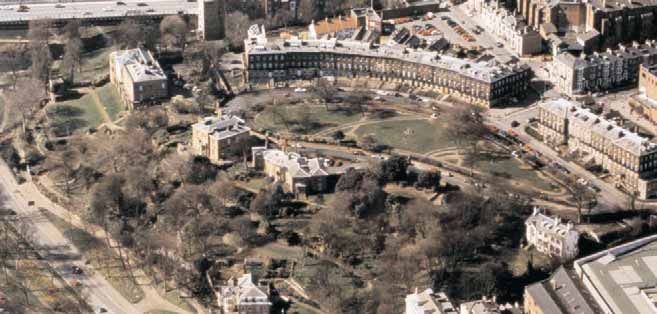
Scarborough 2002

Scarborough 2002                                                             iii

Contents

Scarborough’s Public Realm
    Introduction                                     1
    History of Scarborough                           2
    Land form - topography                           8
    Land form - views and vistas                     10
    Land form - civic gardens                        12
    Urban growth                                     14
    Townscape character                              22
    Town centre commercial frontage                  24
    Landmark structures and buildings                25
    Historically important townscape                 26
    Major vehicular routes                           27
    Points of severance and conflict                 28
    Railway and bus networks                         30
    Cycle and pedestrian movement                    31
    Park and Ride facilities                         32
    Neighbourhood Renewal Assessment Scoping Study   33
Scarborough’s Economy                                56
    The Economic Context for Change                  57
    Scarborough’s Economy Today                      61
    Training & Enterprise Policy Issues              79
    Local and Regional Agencies                      83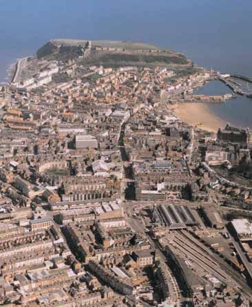
Scarborough 2002
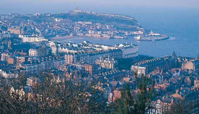
Scarborough’s Public Realm
Scarborough’s harbour and Old Town, viewed from the castle headland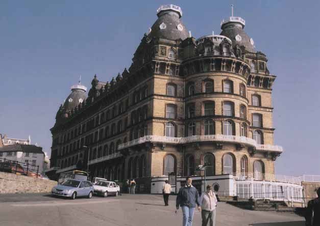
Scarborough 2002

Scarborough’s Public Realm
                                                                                                                  1
Introduction

This section of the report is a review of Scarborough’s public realm
and the information within it has been used to inform the urban
renaissance visioning process.

The public realm audit has been structured as follows:-

  •   graphical illustration of the information gathered, by theme
  •   identification of key issues
  •   review of current initiatives
  •   a framework of potential to accommodate change.

Information gathering and analysis took place between January and
April 2002 and encompassed:-

  • a street by street walk noting quality of buildings and spaces,
    legibility and orientation, uses, movement, linkages and            South Bay cliff lift

    severance, topography, disrepair and vandalism

  • interviews with Scarborough Borough Council technical
    officers regarding planning, conservation, mapping, public
    transport, highways, housing, parks management, regeneration
    funding and tourism

  • briefings from the Town Centre Manager, Arriva Trains
    and Scarborough Coaches

  • reports supplied by Scarborough Borough Council on
    technical issues, policy, regeneration funding, history, tourism,
    economy, development capacity among many others.

Analysis of the key issues has focused attention on the town centre
rather than the residential neighbourhoods, although we have noted
places where environmental stress is evident outside the centre.
                                                                         View of Grand Hotel

John Thompson and Partners would like to thank all those individuals,
in particular the Officers of Scarborough Borough Council, for their
time and patience in helping us develop our knowledge of the town.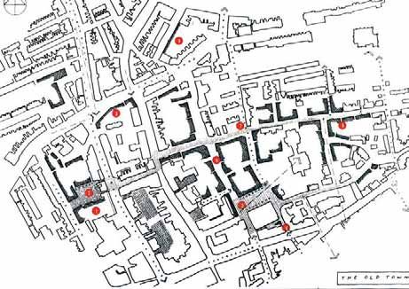
Scarborough 2002

                                                Scarborough’s Public Realm
2
                                                History of Scarborough

                                                            Early 18th century drawing
                                                            of Governor Dicky's house
                                                            and the Well, source of the
                                                            mineral waters which gave
                                                            Scarborough its fame as a
                                                            Spa town

                                                                                          View of Scarborough as
                                                                                          Anne Bronte would have
                                                                                          known it. The town was
                                                                                          the setting for the last
                                                                                          chapters of her novel
                                                                                          “Agnes Grey”

                       View from the Esplanade in 1890,
                         showing the Spa Pavilion in the
                              foreground, with South Bay
                          beyond and the Old Town and
                                 headland in the distance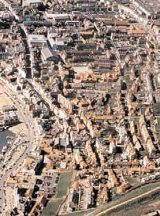
Scarborough 2002

Scarborough’s Public Realm
                                                                                                                                 3
History of Scarborough

The Headland
Scarborough's story starts with the headland: a massive rock
promontory up to 90 metres above the North Sea which separates
two, wide-sweeping bays to the north and the south. Even after many
centuries of erosion, this flat-topped, fan-shaped peninsula is still
equal to eight football pitches in area, almost surrounded by
precipitous cliffs and has its own supply of ground water. Not
surprisingly, such a natural defensive and look-out platform soon
attracted human occupants.

Scarborough headland’s first summer visitors were late Bronze-Age
sea-borne settlers, probably from the lower Rhineland. About a
thousand years later, they were succeeded by the Roman-British
builders of a cliff-top signal tower and fort, designed to give advanced
warning of barbarian invaders. We do not know what the Romans
called Scarborough.

Origins of the name                                                        1685 illustration showing headland and castle
Until the twentieth century it was commonly assumed that
Scarborough owed its name to the rock under which the earliest town
sheltered. Then, from the 1920s, it was argued by Scandinavian
scholars that the name derived from that of a tenth-century Icelandic
Viking, Thorgils, nicknamed Scarthi, because he had a hare-lip or cleft
palate. Scarborough was therefore Skarthi's stronghold.
Subsequently, however, failure to find any archeological evidence of
Scandinavian presence in the town and increasing doubt about the
reliability of Icelandic sagas such as Kormaks saga, which records
supposed events 250 years earlier, has restored belief in the
topographical explanation for Scarborough's name. Scarborough is
the fort next to the deep cleft in the rock, later known as the Castle
Dykes. In other words, if he ever existed, Skarthi has no better claim
to Scarborough than Oliver Cromwell has to Oliver's Mount.

Even the holocaust of 1066, when King Harald Hardrada of Norway is
alleged to have reduced Scarborough to ashes, is now regarded with
scholarly scepticism as yet another tall story. Whereas Falsgrave and
its 21 satellite farmsteads are recorded in Domesday, Scarborough is       Scarborough Castle, walls and ruined keep, situated
not even mentioned in this survey.                                         on the headland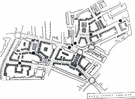
Scarborough 2002

                                                   Scarborough’s Public Realm
4
                                                   History of Scarborough

                                                   The Castle
                                                   Scarborough's recorded history began during the civil wars if the
                                                   1130s when William of Aumale, "who ruled like a king in Yorkshire",
                                                   built the first castle of earth ditch and timber tower on the highest point
                                                   of the headland. A generation later, Henry II spent nearly £700 raising
                                                   a great stone keep on the same site; and under the protection of this
                                                   royal fortress and supplying its needs, a new community was soon
                                                   granted the privileges and customs of a royal borough.

                                                   Town and castle prospered together. The old borough of the original
                                                   settlement quickly spread inland into the new borough. Scarborough
                                                   Liberty absorbed the royal manor of Falsgrave. With its own arable
                                                   fields, animal pastures, spring water supply and water mills, the
                                                   borough became effectively self sufficient. Simultaneously, King John
    1725 map of the harbour and Sandside           invested more than £2,000 in a continuous curtain wall with towers
                                                   and residential halls in his castle, and his son, Henry III, strengthened
                                                   it further with a formidable gateway and barbican.

                                                   A prosperous port
                                                   Expansion and security were accompanied by extraordinary
                                                   commercial rights. A royal charter of 1252 granted its thriving port a
                                                   monopoly as far south as the Humber; a second gave its Thursday
                                                   and Saturday markets monopolies of inland trade; and a third gave
                                                   Scarborough a unique 45-day annual fish fair to coincide with the
                                                   southward passage of the huge herring shoals every August and
                                                   September. By 1300 Scarborough had become Yorkshire's most
                                                   prosperous port.

                                                   Decline 1400-1600
                                                   The next three centuries were times of almost uninterrupted decline.
                                                   Scarborough was overshadowed by Hull, damaged by the Scottish
                                                   and French wars, and weakened by the corruption and greed of its
                                                   self-perpetuating oligarchy. Richard III's attempt to revive
                                                   Scarborough as a principal naval base ended abruptly on the
                                                   battlefield of Bosworth. Later the religious reformation swept away the
                                                   town's three friaries and poverty deprived it of the Holy Sepulchre, one
                                                   of its three medieval churches, and the means to maintain its vital
                                                   harbour pier. In 1377, 1393 resident adults had paid the Poll Tax; by
                                                   1600 barely half that number lived in the town. Now regarded as an
                                                   obsolete burden, the crumbling royal castle was given away to the
    Example of style of dwelling in the Old Town   local Thompson family as a cow pasture.
    (demolished in the 1960s)
Scarborough 2002
Scarborough’s Public Realm
5
History of Scarborough
The North Sea coal trade
Scarborough was saved by sea-coal. After a storm had broken
through the great pier in 1613, the following year, in response to
hundreds of East-coast petitioners, the Privy Council imposed a
permanent levy on all loaded colliers leaving the Tyne and Wear.
For the next two and a half centuries Scarborough's piers were
maintained and built on the North Sea coal trade, and the pier money
grew so great that it paid for much besides, from church and
pavement repairs to Corporation Christmas feasts.
The First Seaside resort - the Spa
The discovery by Mrs Thomasin Farrer in the late 1620s of spa
springs bubbling from the base of South Cliff on to the seashore
marked the beginning of the history of Scarborough as Britain's
(perhaps the world's) first seaside resort. At a time when Europe 1735 engraving of sea bathing at the South Bay
abounded in spa towns where the rich, idle and constipated took beach
mineral water cures and social conventions were relaxed,
Scarborough was the only spa by the sea. Scarborough's South Bay
beach - flat, firm, clean and extensive - was the earliest to become a
pleasure and recreation ground, and Scarborough's cold, rough and
salty sea was the first to be used for the marine cure of gout. Many of
the now familiar features of the seaside - bathing machines and beach
chalets, donkey rides, cliff lifts, boarding houses and naughty
postcards - were invented at Scarborough.
1770 painting by T. Ramsay of
'Holidaymakers on Scarborough
Beach'
Illustration of the Promenade, Scarborough
in 1881Scarborough 2002
Scarborough’s Public Realm
6
History of Scarborough
A holiday destination
During the last three centuries, as a coastal holiday destination,
Scarborough has been downwardly mobile. In the 18th century the
clientele of its Assembly Rooms, theatre and coffee house was
aristocratic and landed gentry. They came by private horse-drawn
coach and stayed for the whole summer season with their families and
servants. In the next century, thanks to the new steam locomotives
and the provision of steam-pumped water, Scarborough's new luxury
hotels accommodated the Victorian business and industrial bourgeois
of the West riding, many of whom settled in New Scarborough, the
town's exclusive South Cliff suburb. Finally, on cheap rail excursions,
in motor coaches by road, and latterly in private cars, the masses
have converged at weekends and bank holidays on the Foreshore's
slot machines, candy floss and fish and chips.
Change and variety
The Grand Hotel, photographed in the late 1890s,
Nevertheless, through all these social and economic changes,
with well-tended gardens in front, not a car park as
today Scarborough has retained its broad variety. Though the herring and
cod are almost extinct and the coastal coal trade has long since
disappeared along with sailing ships, Scarborough has still three
handsome and awesome harbour piers where pleasure craft have
largely displaced working vessels. Though battered during the wars
between the Roundheads and Cavaliers, the once-royal castle
survives conspicuously as an English Heritage monument and a
popular icon. Once humming with shipbuilders, Sandside is now alive
with cafés, ice-cream parlours and bingo players. South Cliff had to
accept a road bridge link in 1865 which was widened in 1928, yet it
retains its superior character in buildings and their occupants. And
800 years after they were first laid out in gridiron pattern, residential
Oldborough is still distinctively different from commercial Newborough
and its modern extension, Westborough.
The Rotunda Museum, designed by William Smith,
the 'Father of Geology'. It was built in the 1820s as
a museum, meeting house and library; the two wings
were added in 1861.
1890s photograph of the beach, donkeys and Seawater BathsScarborough 2002
Scarborough’s Public Realm
7
History of Scarborough
Engineering excellence and municipal pride
Scarborough has continued to expand in area and population.
Thanks to the electric trams (1904-31), the construction of the
massive Marine Drive (1897-1908), and not least to the energy and
vision of Harry Smith, borough engineer from 1897 until 1933, the
North Side became another distinctive part of Scarborough's
kaleidescope. Smith was mainly responsible for Alexandra Gardens,
the Floral Hall and Peasholm Park before the FIrst World War, and the
Glen, the North Bay promenade, Northstead Manor Gardens, the
miniature railways and the open-air theatre after it. During these The Floral Hall (demolished in 1987) was a theatre
built in 1910 in the Alexandra Gardens, the result of
golden years of municipal enterprise the town's 55 acres of public efforts by Harry Smith, the enterprising borough
parks grew to 350 acres and Scarborough became truly a garden by engineer
the sea.
Housing development
During the inter-war years Scarborough's population levelled out at
about 40,000 but spread over a widening hinterland. Slum clearance
and Council re-housing after 1918 led to the creation of new estates
on the perimeter at Edgehill, Barrowcliff, and from the 1950s most
distantly at Eastfield. Light industry in the form of coach-building,
printing, engineering and food processing also found the outskirts
more accessible to the main A64 road link.
Declining fortunes
But Scarborough could not escape the dire consequences of cheap
Mediterranean holiday packages and the changes brought about by
de-industrialisation. In the last quarter of the twentieth century decay
and dereliction became visible features of its infrastructure: Hotels
closed and some of the best were demolished; the Floral Hall
vanished; the open air theatre that had once seated 8,000 spectators
became a wasteland; the Grand Hotel was bought by Butlins; the
Royal Opera House was wrecked; the South Bay Pool was
abandoned; the Mere became a swamp, and trees grew out of what 1940 poster advertising Scarborough as a
had been Marshall and Snelgrove. A penniless Council seemed holiday destination
powerless to intervene. The only exception to this sad catalogue was
the triumphant conversion of the old Odeon Cinema into Sir Alan
Ayckbourn's new Stephen Joseph Theatre.
At the beginning of the twenty-first century Scarborough sits poised
uncomfortably on the sharp edge between further, perhaps
irreversible, decline, and the promise of an urban renaissance. Given
past precedents and present initiatives, the signs seems more
promising than pessimistic.
With thanks to Dr Jack Binns for his kind contribution of this text
1897 view of North Bay; the pier was destroyed by a
storm in 1905Scarborough 2002
Scarborough’s Public Realm
8
Land form - topography
Scarborough has undergone very different
patterns of settlement north and south of the ridge
that runs up to the castle headland
Steep slopes are part of Scarborough’s coastal
character
The castle headland with the Old Town occupying
the slopes between the ridge and the Foreshore. In
the foreground the Spa Complex is partially built
into the slope behind it.
The unique land form of hills, valleys and cliffs has fundamentally
influenced the development of Scarborough over time. Human
ingenuity has harnessed the topography to advantage; from periods of
South Cliff with cliff slopes leading down to the Spa fortification and defence, to leisure and resort development, the slopes
Complex and Olivers Mount beyond have been turned into great assets for the town. The development of
Scarborough has responded to its unique topographical situation by
creating:
• access routes to the town along valley bottoms and contour lines
• built form that exploits south facing slopes to minimise
overshading
• level changes that occur within buildings themselves
• individual buildings and whole urban blocks oriented to gain
maximum advantage of the aspect and prospect afforded by the
topography.
Erosion of the castle headland
The disadvantages of this land form have been that coastal erosion
has been a constant factor on the seaward side, whilst during its later
period of expansion, the presence of Oliver’s Mount has resulted in a
discontinuity of the town’s development to the south.Scarborough 2002
Scarborough’s Public Realm
9
Land form - topography
Current initiatives
Scarborough Borough Council is implementing a range of
management strategies to respond to the the dynamic geology of the
town’s land form.
These include:-
• a Coastal Defence Strategy to manage sea walls, breakwaters
and stability of the land. This strategy resulted from a series of
detailed studies that include dynamic modelling of the coastline’s
behaviour over time and hydrology Cliff lifts enhance access between the high level
urban areas and the shore line
• landscape management programmes which conserve the valleys
as civic gardens and stabilise the slopes that they themselves
occupy. Current projects of this type include the restoration of
Peasholm Park, stabilisation of St Nicholas Cliff and repair and
renewal of Valley Gardens
• retention of the three cliff lift services.
Issues for the future
Whether existing funding that is available under the Coastal Protection
Strategy can be ‘bent’ to support projects that are related to the urban
renaissance programme is an issue which may need to be considered
in the future. Works programmed under the Coastal Protection
Strategy might at the same time provide improved access to the Spa
Complex and the South Bay Pool. These works might also contribute
to future improvements to the Foreshore, Sandside and any improved
links between North Bay and South Bay.
The future of the South Bay Pool is inextricably linked to the Pedestrian bridges resolve severe level changes
implementation of the Coastal Protection Strategy. For the South Bay and facilitate horizontal circulation
Pool project to succeed, a flexible and robust solution will be required.
Ramped and sloping paths are the most common
method of accommodating level changesScarborough 2002
Scarborough’s Public Realm
10
Land form - views and vistas
Scarborough’s Old Town has a tightly knit medieval
street pattern that affords occasional glimpsed views
of the landscape beyond
1 3
4
The keep of Scarborough Castle provides a single
point of orientation from most parts of the town
2
3
A walk through Scarborough reveals a rich mix of views and vistas,
from the tightly knit streets of the Old Town, to the expansive views of
the sea front and the town’s ornamental gardens.
Views from the Valley Gardens of the North Sea are
framed by the arches of the Spa Footbridge
Peasholm Park provides vistas inland of its own wooded valley and
outwards towards Peasholm Park Island, North Bay and the possible
North Bay development site. (1)
Valley Gardens form an exemplary composition of buildings and
landscape that draws visitors down to the sea under the arches of a
series of bridges. (2)
The Castle and Oliver’s Mount provide the most expansive views and
their prominence indicates a relationship between the two that could
be better exploited for the benefit of the town. (3)
Oliver’s Mount affords views of much of Scarborough
and highlights the important visual relationship The Grand Hotel demonstrates that Scarborough can absorb
between the Mount and the Castle headland
significantly scaled built form that, if carefully designed, can enhance
rather than detract from the more human scale of the town’s streets.
(4)Scarborough 2002
Scarborough’s Public Realm
11
Land form - views and vistas
Current initiatives
There are no specific local policies related to strategic views in the
town, but most landscape issues are however dealt with under
planning control relating to conservation. There are local policies
concerned with the protection of landscape features particularly the
coastline and historic parks and gardens. Some of Scarborough’s
bridge structures, the Castle and St. Mary’s Church have all benefited
from lighting strategies that significantly improve the town at night.
Key issues
At present, planning controls include the protection by listing of key Vistas framed by bridge arches can draw attention
to key buildings such as the Rotunda
buildings that contribute to the unique character of Scarborough.
There is, however, little protection of these buildings from the effects
of more recent economic decline. Other initiatives that aim, for
example, to generate increased dynamism in the local economy, will
be a key goal in this respect.
Accommodating change
An extended, town-wide lighting strategy that links the highly symbolic
landmarks of Oliver’s Mount and the Castle could be undertaken.
This could be a significant intervention that could be achieved at a
relatively low cost, whose impact could be limited to certain times of
Views across Peasholm Lake towards North Bay
the year.
The Grand Hotel, St. Nicholas Cliff
The Castle and its keep viewed from North BayScarborough 2002
Scarborough’s Public Realm
12
Land form - civic gardens
Valley Gardens viewed from the Spa foot-bridge
showing the formal layout of planting beds with the
backdrop of wooded valley sides
2
The main facades of the former villas in the
Crescent, now civic buildings, orientated towards
1
Valley Gardens
Two deep valleys - Valley Gardens (1) and Peasholm Valley (2) -
penetrate the town in a roughly west to east direction and are used as
civic gardens. Together, the two parks have great potential for linking
many parts of the town as walking routes.
Peasholm Lake where, until the 1980s, naval
battles were re-enacted using model boats.
Firework displays also took place in the park The Valley Gardens consist of a linear arrangement of different
landscaped spaces, from lakes and woodland below Grosvenor Road
to the formal planting beds and boulevard under Cliff Bridge. On the
seaward side, the valley is dominated by over-engineered highway
structures that sever the connection between the valley and the sea.
Peasholm Park is a clever exploitation of land form and watercourse
that uses soil extract to create both lake and ornamental hillock
features. The park was initially designed as a resort facility, with more
land being added to it at a later date. A path network has been
developed to include Peasholm Glen, the Cemetery and Peasholm
Riverside walks run the length of Peasholm Beck.
watercourse from the formal Japanese style gardens
to the more natural woodland landscape upstream
In addition, a series of cliff-top gardens exploit the level change
between the town and the shore line, most notably Holbeck and St.
Nicholas Gardens.Scarborough 2002
Scarborough’s Public Realm
13
Land form - civic gardens
Current initiatives
Scarborough has had the good fortune to inherit a wealth of civic
gardens and open spaces, many developed by entrepreneurs who
were associated with the growth of the resort economy.
The responsibility of this infrastructure and paying for its maintenance
has become a burden for the Borough Council and is under review.
Scarborough Borough Council has a series of initiatives for the
maintenance of the civic gardens which are being funded from a
range of sources, including normal Council revenue, lottery grants and The Castle grounds and ramparts are little used in
comparison to other open spaces in the town
government regeneration funds. These projects include:-
• stabilisation works to St Nicholas Gardens
• restoration works to Peasholm Park
• repair works to Valley Gardens.
Accommodating change
Scarborough Borough Council Technical Services Department have
the responsibility of delivering the management programme for all
public spaces across the Borough. Although the delivery of this
service is very good, the resource burden of managing 547 Ha of
parks and 180 Ha of woodland is immense. Much of the land within
Scarborough town is managed by a staff of 20-30 people who operate
under a capped budget.
For the future, there might be opportunities linked to the wider urban
renaissance programme, to develop public-private sector partnership
agreements for the management of Scarborough’s civic gardens. For
example, the landscape associated with Wood End Museum could be
transferred to the Museum as a management entity whether this be
for museum services or private sector use.
In Holbeck formal Italianate gardens are integrated
with the organic layout of paths that lead to the
shoreline
West Square is an example of the many Victorian
squares framed by buildings that provide amenity to
occupiers and passersbyScarborough 2002
Scarborough’s Public Realm
14
Urban growth to the 12th Century
The 1160 castle followed a history of earlier
fortification of the headland in the Iron Age, Bronze
Age and Roman periods
In the twelfth century the harbour was the focus of
both shipping and fishing
The termination of Eastborough which was formerly
part of a direct route from St Mary’s Church to the
harbour. West Pier was a later addition to the
harbour. • The 12th Century settlement of Oldborough was defined by
defensive walls and ramparts.
• The settlement exploits the protection and natural land form of
the headland that sheltered it from north-westerly winds.
• The northern boundary of the settlement was defined by the
access road to the Castle, which is possibly of Roman origin.
• As most communication with the outside world was by sea, the
settlement boundaries were gated to the north and on the
harbour side.Scarborough 2002
Scarborough’s Public Realm
15
Urban growth - later middle ages
Eastborough extends westwards to become
Newborough
Blands Cliff links Foreshore Road to Newborough,
Scarborough’s principal commercial street and St.
Helen’s Square and Cross Street beyond
• Expansion beyond Newborough brought the town’s defences
south west to a line that corresponds with North Marine Road,
North Street and Valley Road.
• Falsgrave emerges as a settlement in its own right.
• A route to Filey was established across the Valley to Ramshill.
The scale of the Market Hall on St Helen’s Square
indicates the extent of trading that once took place
in the townScarborough 2002
Scarborough’s Public Realm
16
Urban growth to the 1750s
Resort development on Falconer Road including the
Royal Hotel and St. Nicholas Cliff
Bar Street on the line of redundant town defences
provides commercial frontage between Westborough
and the Cliff edges
The corner of Westborough and Victoria Road marks • Newborough was developed as an extension of Oldborough as
the former limits of Scarborough and the beginning of
Falsgrave
commercial activity increased beyond the former limits of the Old
Town.
• Manufacturing output increased as trading on the North Sea
developed.
• The Old Town’s defences became redundant as new ditches
and ramparts were constructed.
Falsgrave established itself a centre in its own right
with development extending towards the Seamer
Road CornerScarborough 2002
Scarborough’s Public Realm
17
Urban growth to the 1850s
Built in the 1840s, the L.N.E.R. terminus significantly
increased the accessibility of both goods and
passengers to Scarborough.
Further resort development along South Cliff with set
piece designs such as The Crown Hotel
• Scarborough was consolidated as a resort with new housing Ramshill established itself as a centre in its own right.
built to support an expanding middle class population.
• Artisans’ housing laid out in terraces was also built to support
the growth of the manufacturing industry.
• Suburban expansion of the Weaponess area to the south was
limited by the scarp face of Oliver’s Mount.
• Significant westward expansion created the Prospect and
Gladstone neighbourhoods.
The Cumberland Hotel along with the Carlton and the
Esplanade define the southern edge of Valley
Gardens.Scarborough 2002
Scarborough’s Public Realm
18
Urban growth to the 1890s
Filey Road in the foreground of this image serves
suburban development around the base of Oliver’s
Mount
Semi-detached houses with aspect onto Shuttleworth
Gardens
• Use of the L.N.E Railway increased accessibility to the town,
attracting visitors and improving the distribution of goods
Grand suburban houses in the Weaponess area, a • Manufacturing increased as accessibility developed and the
series of looped roads that lead up to Oliver’s Mount
William Street area was established, characterised by a
multitude of workshops
• South Cliff resort development expanded to include more hotels
and lodgings as grand design statements, such as the Prince of
Wales Gardens.
Typical late Victorian expansion of the Gladstone
Road areaScarborough 2002
Scarborough’s Public Realm
19
Urban growth to the 1950s
Turn of the century by-law terraced housing
bordering the cemetery with the end of terraces
orientated towards open space
Semi-detached houses along Glenbridge and
Ryndleside with aspect away from Peasholm Ravine
• Suburban expansion along the main arterial routes towards
Scalby, Seamer and Osgodby. Barrowcliff has pockets of environmental stress with
• Housing in the expansion area was typically of low density with vacant and vandalised houses. This is a location
where funding for housing renewal is apparently
increased space for private cars, both on highway and on plot required.
• Changing space standards also contributed to dispersal, moving
away from by-law housing and towards Parker Morris space
standards, impacting on amenity space in and around the home.
• The most typical housing type was semi detached with very little
diversity, characterised by large building set-backs and on
plot parking.
• Industrial uses reduced their reliance on rail and spread along the
main arterial routes, notably the A64.
Barrowcliff SureStart office is typical of the low
density housing with minimal street structure and
poor quality boundaries.Scarborough 2002
Scarborough’s Public Realm
20
Urban growth
Current Initiatives
Any outward growth of Scarborough is limited by sea, protected
landscape and the town’s topography. Over the past 10 years, Local
Plan policies have led to a consolidation of the southward expansion
of the town, including the A64 corridor and in sites around Eastfield
and Seamer. Over time, planning briefs for these areas have evolved
from ‘traditional’ approaches to the zoning of uses, to more recent
guidance that places a greater emphasis on sustainable residential
quality: a range of residential densities; integrated public transport and
mixed-uses.
More recently, national planning guidance has changed, including the
2002 Planning Policy Guidance Note 3 (PPG3) on Housing. Under
PPG3 it is now mandatory for local authorities to assess the
availability of development land within existing urban areas, prior to
further outward development on the urban fringe. This is important in
towns such as Scarborough, which has experienced decline,
Outward growth of the settlement is limited by depopulation and negative impacts on property values.
constraints to the east, north and west making
southern expansion the easiest option.
Key issues
Depopulation has resulted in many empty properties in the town
centre, particularly accommodation over retail premises. It is in these
key locations that the urban renaissance of Scarborough could start,
given a new confidence in rejuvenated public spaces, new economic
vitality and more people inhabiting the town centre.
Rather than view the greenfield-brownfield debate in Scarborough as
mutually exclusive issues, the key factors that require resolution are:-
• To complete the ongoing capacity study of the potential of
Scarborough’s vacant and under-used land and empty buildings
to absorb growth
• To review what critical mass of new population might be
required to bring new vitality to the town
• To set re-population targets to be in line with the town’s capacity
to grow
• To apply sequential testing principles to land release; and
• To review these targets to balance the aspirations of PPG3 with
the market’s perceived desire for a wide range of property
choices.
Areas of planned growth as identified in the 1999
Scarborough Borough Local Plan which concentrates
on greenfield land around EastfieldScarborough 2002
Scarborough’s Public Realm
21
Urban growth
Accommodating change
As Scarborough’s town centre has lost some of its population, there
are empty sites and buildings that can be used to bring about Capacity for development and consolidation in the
town centre, focusing on vacant and under-used land
significant change in the way that the town centre functions. The
and opportunities housing stock renewal
renewal of neighbourhoods in conjunction with the reuse of under-
used land and buildings will have several benefits:
• turn around trends that are tending to lead towards
environmental degradation in some areas
• strengthen values where the property market might be
vulnerable to decline
• follow the aspirations of other neighbourhoods that are
experiencing gentrification.
At least two areas were identified in walkabout surveys that warrant The old hospital site and William Street Car Park hold
further study: the William Street Car Park area; and the Friary area of the key to increasing town centre growth and renewal
the Old Town. These opportunities are discussed in the
Neighbourhood Renewal Assessment Scoping Study that follows later
in this document.Scarborough 2002
Scarborough’s Public Realm
22
Townscape character
Foreshore Road
Resort architecture - the Esplanade
Medieval Core
The medieval core is characterised by a series of tightly
knit streets laid out along the ridge that leads up to the
Monumental set piece - the Rotunda, Valley Road castle headland. Buildings, which normally have a
minimal set-back from the street line, often respond to the
land form by absorbing level changes within them.
Town Centre
The town centre has many of the characteristics that are
commonly associated with town centre retailing
environments: the bustle of commerce followed by a
steep drop-off of activity as the evening approaches;
many larger scale buildings that tightly define the spaces
in which they stand; ‘shatter zones’ - dislocated spaces
that are dominated by rear service access, and particular
Victorian terraced housing near Victoria Road points of vehicular / pedestrian conflict, the result of high
footfall and vehicular usage in the town centre area.Scarborough 2002
Scarborough’s Public Realm
23
Townscape character
Key to townscape character areas
Valley Landscape
Views into and out of the Valley Gardens, a significant
point of arrival that leads to Scarborough’s shoreline, are
framed by trees, bridge structures and buildings
constructed at the top of the steep slopes. As one makes
progress through the Valley Gardens, woodland gives
way to a more formal, engineered landscape, and
eventually to an over-engineered highway, a major point
of vehicular / pedestrian conflict.
Resort architecture
Those parts of Scarborough that were constructed at the
height of the town’s development as a resort are typified
by buildings of large volume and an almost grandiose
scale. As in other seaside towns, many of the streets
were constructed perpendicular to the shoreline, with bay
windows provided for the occupants to enjoy oblique
views of the ocean. In the urban design of these areas,
the developers have set out to impress, creating
architectural set pieces and landmarks.
Victorian expansion
The streets and buildings of the Victorian period are
identified by their orderliness, often prescribed by the
introduction of the local authority by-laws that were
created to try to ensure that even the most modest
dwellings had access to a modicum of amenity and
sanitation. In the more wealthy parts of town, the
Victorian builders provided large homes that are so robust
that many have been used very flexibly over time.
The Twentieth century
Developed further away from the town’s core,
Scarborough’s twentieth century suburbs are typified by
wider streets, a significant amount of space given over to
the parking of cars and low overall densities.Scarborough 2002
Scarborough’s Public Realm
24
Town centre commercial frontage
4
The bustle of the Westborough - Newborough -
3 2 1
Eastborough commercial artery
5 1
Paving in Westborough, which was pedestrianised in
2
the 1980s, lacks coherence and impact
The figure-ground drawing above has been made from a detailed
survey of Scarborough’s retail frontage, and includes any voids not
converted to other uses. What this clearly shows is the strength of the
Westborough - Newborough - Eastborough - Sandside artery (1 - 1),
compared to the rather more fragile Falsgrave Road - Victoria Road -
Street furniture in Westborough Castle Road axis (2 - 2).
Perhaps the most vulnerable of all of the retail frontages in the town
are the Dean Road (3) and North Marine Road (4) spurs, which
appear to lack significant anchors at their ‘unconnected’ ends. The
heavy footprint of the Safeway superstore is clearly visible (5).
One conclusion that can be drawn from the survey is that there is
probably excessive retail provision to serve the town at its current
level of economic activity. However, care must be taken to evaluate
any proposals for conversion / consolidation of the retail provision
against demand predicted by future growth scenarios for the town.
Paving in North Street - Waterhouse Lane, a
pedestrianised extension of Newborough. The site
at this intersection is scheduled for redevelopmentScarborough 2002
Scarborough’s Public Realm
25
Landmark structures and buildings
1
5 2
3 The Valley Bridge, whose structure was recovered
from York by an entrepreneur in the 1880’s
6
4
7
8 9
The Stephen Joseph Theatre
10
Scarborough has a rich diversity of landmark buildings, structures and
architectural set pieces. The drawing above identifies a number of
these, some of the more significant of which are annotated below:-
The Grand Hotel
1. Scarborough castle
2. St Mary’s Church
3. Market Hall, St Helen’s Square
4. The Futurist Theatre
5. Dean Road Gaol
6. Albermarle Crescent and Church
7. The Crescent
8. The Stephen Joseph Theatre - former Odeon Cinema
9. The Grand Hotel
10. The Spa Complex
Dean Road GaolScarborough 2002
Scarborough’s Public Realm
26
Historically important townscape
3
2
1
Scarborough has implemented a variety of conservation measures to
control development and respect existing townscape within historically
important areas.
• The conservation area identified above (1) has been the basis for
controls such as design guides for building frontages, shop-fronts
and conversions. There have also been grants provided for
householders and occupiers for improvements such as retaining
traditional sash windows and boundary railings.
• Much of Eastborough and Newborough contain archeological
deposits. Proposed new developments in these areas (2) will
require designs to respond to the findings of Archaeological Field
Evaluations as part of development proposals. They must also
demonstrate preservation that does not prejudice future
investigation.
• The castle headland (3) is a Scheduled Ancient Monument of
local and national importance and conservation is seen as the
highest priority. In this context management is essential to control
Above: examples of historically important
townscape at risk.
human activity in order to avoid needless erosion. However,
balancing preservation with the need to make the site more
useful and to support Scarborough’s renaissance, rests with
English Heritage and therefore further studies will be required.Scarborough 2002
Scarborough’s Public Realm
27
Major vehicular routes
2
A64, the Seamer Road corridor, at the point where it
enters Scarborough
1
3
The A165 in Scarborough town centre, close to its
intersection with the A64, a major point of severance
in the town
1 2
The A64, York to Scarborough (1 - 1), and the A165 Whitby to
Bridlington (2 - 2) roads converge in Scarborough town centre
adjacent to the railway terminus (3).Scarborough 2002
Scarborough’s Public Realm
28
Points of severance and conflict
Pedestrian severance at the intersection of Valley
Bridge Road and Somerset Terrace
Northway (the A165) which is dominated by traffic
and causes severance in the town centre at the
junction of Westborough and Falsgrave Road
Dark areas indicate points of significant vehicular /
pedestrian conflict or severance in the town centre. These
occur mainly on the A64 and A165 corridors and at points
on the town’s one way system.
The lighter shaded areas show the principal pedestrian
attractors in the town centre.Scarborough 2002
Scarborough’s Public Realm
29
Points of severance and conflict
6
5 E
D
1 4
A
3
B
2 C
Key
Points of significant vehicular / pedestrian conflict
1. Westborough and Northway (A64 / A165 intersection)
2. Valley Bridge Road and Somerset Terrace
3. Huntriss Row and Falconers Road
4. St Nicholas Street and entrance to St Nicholas Gardens
5. St Nicholas Street and Newborough
6. Castle Road and North Marine Road
Principal pedestrian attractors
A. Stephen Joseph Theatre
B. Scarborough Railway Terminus
C. The Crescent and Gardens
D. Westborough / Newborough / Eastborough
E. Eastborough to SandsideScarborough 2002
Scarborough’s Public Realm
30
Railway and bus networks
Scarborough railway station
Scarborough railway terminus
Key
Train/bus network
Bus routesScarborough 2002
Scarborough’s Public Realm
31
Cycle and pedestrian movement
The pedestrian bridge access to the Spa Complex
Pedestrian access to Plantation Hill
Legend
Principal cycle routes
Dog and Duck Lane near Quay Street
Valley, cliff top and seashore
pedestrian routes
Areas of beach (exposed at low tide)
Pedestrian priority area on Foreshore RoadScarborough 2002
Scarborough’s Public Realm
32
Park and Ride facilities
Bus service in Scarborough town centre
1
Over 13,000 car parking spaces are currently
available in or near Scarborough town centre,
drawing traffic close to the heart of Scarborough.
A64
2
Park and Ride sites at Seamer Road (1) and Filey Road (2) as
identified in the 1999 Scarborough Borough Local Plan
The provision of Park and Ride in these sites is integrated into other
road improvements including an A64 link to a new Osgodby bypass.
The Seamer Road corridor and the Mere, proposed
site of one of Scarborough’s projected Park and
Ride sites.Scarborough 2002 Scarborough’s Public Realm 33 Neighbourhood Renewal Assessment Scoping Study Summary Our preliminary Neighbourhood Renewal Assessment (NRA) Scoping Study provides a basis for believing the scale and nature of the problems of social and economic decline and related housing market failure in and around the centre of Scarborough warrants a strategic, long-term, multi-agency approach which could benefit from the focus and statutory significance of Renewal Area declaration. We therefore recommend that a Renewal Area proposal be developed through undertaking a Neighbourhood Renewal Assessment across an area that is bounded by the sea in the north and west; Peasholm Park, the former railway line and Safeway supermarket in the east and Valley Road in the south. Neighbourhood Renewal Assessments generally comprise a house condition survey, a social survey, a business survey, an environmental assessment and a series of related workshops, focus groups and stakeholder meetings in which information is processed, options for change generated, options appraised, a delivery vehicle chosen or created and a ten year package of agreed interventions is negotiated and commissioned. NRAs have been carried out on areas including up to 9,000 homes and frequently include whole town or city centres. In Scarborough an NRA on the scale proposed could involve upwards of 3,000 residential properties and take up to six months to complete. In our view it should include a detailed capacity study which looks at the scope for reinvestment in land and buildings and resettlement of households which are currently badly housed or badly served by the private rented sector. This will require the development of a convincing cross tenure investment plan that is closely integrated with the commercial renaissance of the town centre. For these reasons, the NRA could usefully be steered by the Town Team and undertaken by a combination of Council officers and specialist consultants to provide a high level of confidence to all the key stakeholders.
Scarborough 2002

                        Scarborough’s Public Realm
34
                        Neighbourhood Renewal Assessment
                        Scoping Study
                        Policy context
                        The Local Government and Housing Act 1989 introduced statutory
                        Renewal Areas, the provisions of which remained largely unchanged
                        in the 1996 Housing Grants, Construction and Regeneration Act.

                        Renewal Areas, which normally last for ten years, provide authorities
                        with scope to improve the housing and general amenities of an area in
                        which social and environmental problems are combined with poor
                        housing. The intention was to create a true partnership between the
                        local authority, residents and private sector interests. The approach is
                        expected to secure maximum impact by increasing community and
                        hence market confidence in the future of an area and, through this,
                        help to reverse the process of decline.

                        Coupled with the Renewal Area concept was the Neighbourhood
                        Renewal Assessment (NRA). The NRA is an aid to decision-making
                        comprising a series of logical steps which, when taken together,
                        provide a thorough and systematic appraisal method for considering
                        alternative courses of action for an area. The NRA considers a range
                        of issues including boundary definition, economic assessment,
                        technical feasibility and socio-environmental assessment.

                        The NRA was developed to help authorities to develop area based
                        strategies which are more forward looking and wider ranging than had
                        generally been the case, and to this end was designed to:

                           • help authorities to draw boundaries around cohesive
                             neighbourhoods;
                           • help authorities to think about the long term future of an area by
                             encouraging them to consider the cost consequences over 30
                             years of alternative options for the area;
                           • encourage authorities to consider all the land uses within the
                             area under consideration and to look at ways of dealing with
                             housing in poor condition within a wider context than hitherto;
                           • encourage authorities to think broadly about possible alternative
                             courses of action for the area, taking account of both public and
                             private cost implications, along with social and environmental
                             factors which cannot be quantified in financial terms;
                           • encourage authorities to take account of a wide range of views
                             including both those of people who already have an interest in
                             the area (e.g. residents, landowners and local business people)
                             and those who might want to take an interest (e.g. private
                             developers and RSLs); and
                           • help to build up a commitment by all concerned to securing the
                             implementation of the chosen strategy.

                        Neighbourhood Renewal Assessment and Renewal Areas (DETR, 1997).
                        Housing Research Summary is available at: http://www.housing.odpm.gov.uk/hrs/hrs071
Scarborough 2002
Scarborough’s Public Realm
35
Neighbourhood Renewal Assessment
Scoping Study
Background
The material supplied by Scarborough Borough Council suggested that
there was a persistent problem of social and economic deprivation
concentrated in Castle Ward and that this was associated with the high
number of houses in multiple occupation, formerly used as hotels and
guest houses.
We were advised by officers of the Council that whilst qualitative
improvements had been achieved through a HMO Registration Scheme
and the use of enforcement powers, the scale and continued growth of
the private rented sector and concentration of poor and vulnerable
households within it remained a particular cause for concern.
Several studies of seaside towns have identified this shift to private
renting and multiple occupation throughout the 1980s and 1990s. It has
sometimes been associated with the targeting of former hotels and guest
houses by public agencies resettling vulnerable people from institutional
care, often local support and health care services have been
strengthened and housing association investment has been targeted at
the area.
The development of local support services and the continued availability
of a pool of cheaper housing easily accessible for rent has tended to
enhance the area’s attractiveness to a wider range of agencies seeking
to find accommodation for people experiencing social and financial
difficulties in the rural hinterland and in the big conurbations. This has
reinforced a pattern of settlement and social churn influenced by the
availability of Assured Shorthold Tenancies and Housing Benefit. It has
helped to concentrate people with low spending power adjacent to town
centres once underpinned by a strong tourism economy. Declining retail
vitality and commercial values have frequently been associated with this
phenomenon. In a number of cases owner occupier confidence has been
eroded as people have sold out to private landlords fearing that the
changing social composition of the area will threaten their equity stake.
This process has been extensively monitored and catalogued over a
number of years. In a number of locations the local authorities have
undertaken Neighbourhood Renewal Assessments to discover more
about the problem and to develop strategies to combat it. In Morecambe,
Rhyl, Hastings and St Leonards and Maryport for example the local
authorities declared Renewal Areas to establish a multi-agency approach
which focuses the strategic use of powers and resources over a 10 year
programme of intervention aimed at restoring confidence and reinvesting
in property and the public realm.
We were asked to look at the appropriateness of conducting a
Neighbourhood Renewal Assessment in Scarborough and the extent of
the study area and possible scope of strategic intervention that could be
accommodated within a Renewal Area declaration.Scarborough 2002
Scarborough’s Public Realm
36
Neighbourhood Renewal Assessment
Scoping Study
Methodology
Council officers provided us with an extensive background reading list
covering the regional and sub-regional context; housing and
employment market information and forecasts, Tourism and Town
Centre Management data and detailed HMO mapping. After absorbing
this material we were given a detailed briefing on the private sector
housing situation and undertook initial site visits with Senior Council
Officers.
We then worked closely with officers representing Housing,
Environmental Health, Heritage and Conservation and Town Centre
Management and with a local Surveying and Property Management
Company to develop a simple method of appraisal of property type,
condition and value which we used to undertake a systematic
appraisal of the areas around the centre of the town identified as of
concern to officers.
We met with a number of agencies that provide support to vulnerable
people and with some of their clients in group discussions and we
mapped the use, condition and value characteristics of residential
property in and around the centre of the town. We then looked at the
potential for value enhancement and beneficial social and economic
change through incremental reinvestment in sites and buildings to
improve housing quality and value and create a more settled and
sustainable environment for vulnerable people.
Finally we discussed our findings with the authors of the CURS
Yorkshire and Humberside Study: Changing Housing Markets and
Urban Regeneration and provided a summary for inclusion in the
Council’s Housing Strategy update to the Government Office.Scarborough 2002
Scarborough’s Public Realm
37
Neighbourhood Renewal Assessment
Scoping Study
Early NRA guidance prescribed certain criteria for declaration of
Renewal Areas which related to the number of unfit or "actionable"
properties; the proportion of private sector dwellings; and the extent to
which households were dependent on welfare benefits. Over the
years and consistent with Government increasing freedoms and
flexibilities for local authorities alongside changes in financial support,
declaration criteria have been relaxed as has the need to obtain
Secretary of State consent prior to declaration.
Even though recent Regulation Reform Orders have given local
authorities the widest scope to determine where and how Renewal
Areas should be targeted, in our scoping study we focused on
confidence (relative aggregate market value); environmental quality
(dilapidation, dereliction and neglect); and house condition (external
repair); blocking data up across 18 zones. In a full NRA we would
expect a much more detailed survey including 100% of dwellings
externally surveyed and at least 10% surveyed internally (maybe 20%
in certain streets where high numbers of HMOs are located. Blocking
up of data would be to small clusters of dwellings permitting "priority
investment block" judgements to be made.
In a full NRA a 100% social survey would be attempted with an
expected response rate of 30%. This could be augmented with a
sample housing needs survey. Our scoping study identified the need
for extensive public consultation and stakeholder development as
current high levels of "social churn" and tenure segregation present
barriers to the level of social cohesion needed to underpin a
sustainable regeneration strategy for the area.You can also read