Seismic hazard estimation in stable continental regions: challenges and opportunities
←
→
Page content transcription
If your browser does not render page correctly, please read the page content below
Seismic hazard estimation in stable
continental regions: challenges and
opportunities
T.I. Allen
Positioning and Community Safety Division, Geoscience Australia, Canberra.

ABSTRACT
Damaging earthquakes in Australia and other regions characterised by low seismicity are
considered low probability but high consequence events. Uncertainties in modelling earthquake
occurrence rates and ground motions for damaging earthquakes in these regions poses unique
challenges on forecasting seismic hazard and the subsequent use of this information for improving
seismic safety within our communities. Key challenges for these regions are explored, including:
the completeness and continuity of earthquake catalogues; the identification and characterisation of
neotectonic faults; the difficulties in characterising earthquake ground motions; the uncertainties in
earthquake source modelling, and the use of modern earthquake hazard information to support the
development of future building provisions.

1   INTRODUCTION
Forecasting seismic hazard in stable continental regions (SCRs) brings unique challenges to hazard
modellers and practitioners in terms of the characterisation of seismic sources and their ground motions. By
their very nature, SCRs experience significantly lower earthquake rates compared to tectonic plate margins,
such as New Zealand. As a consequence, the typical observation period of historical (instrumental)
seismicity is significantly shorter than the seismic cycle of rare large earthquakes that may generate extreme
damaging ground motions on any given fault.
Seismic hazard assessments in SCRs are often more dependent on earthquake catalogues and the
relationships between small-to-large earthquakes (e.g., Gutenberg & Richter 1944) than in seismically active
regions, with a high-dependence on the rates of small-magnitude earthquakes to inform the occurrence rates
for larger events. The completeness of earthquake catalogues, together with changes in observatory practice
over time delivers challenges in ensuring the catalogue provides a consistent representation of an

                                                  Paper 392
2019 Pacific Conference on Earthquake Engineering and Annual NZSEE Conference                                1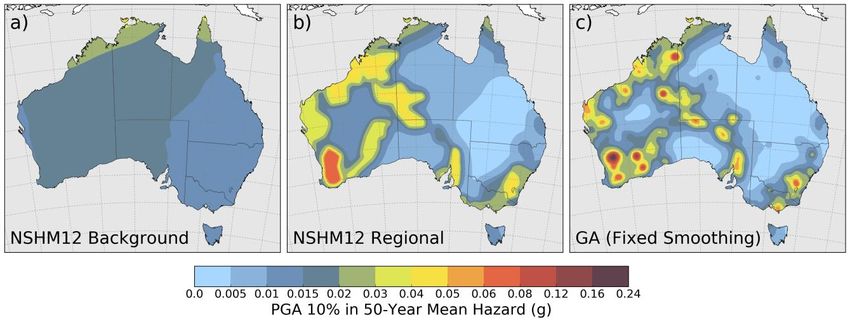
earthquake’s size over time, making the estimation of earthquake occurrence parameters highly sensitive to
these practices and the relative detection thresholds of the seismic networks.
The characterisation of seismic sources can be undertaken using several philosophical approaches, each of
which are scientifically defendable. For the 2018 National Seismic Hazard Assessment (NSHA18) of
Australia (Allen et al. 2018a), the epistemic uncertainty of seismic sources was incorporated through the
inclusion of 19 independent models (Griffin et al. 2018), contributed by Geoscience Australia and third-party
sources. This allowed for the exploration of source-model uncertainty, but presented further challenges in
assessing the utility of different source-model types (e.g., smoothed or zoned seismicity) over different
spatial scales and return periods of interest.
In Australia, the limited observation period is exacerbated by the sparse seismic recording network relative to
the size of the continent. This means that even when a moderate-to-large earthquake does occur within the
continental crust, it will often be poorly recorded in terms of its ground-motion accelerations. For example,
the nearest seismic station to the 2016 MW 6.1 Petermann Ranges earthquake in the Northern Territory
(Hejrani & Tkalčić 2018; King et al. 2018) was located more than 160 km from the earthquake’s coseismic
rupture. Consequently, the use of rapid seismic deployment kits for these events are key, not only to
understanding the mechanism of the earthquake rupture, but to also capture strong-motion data from
potential large aftershocks. Nevertheless, the relative paucity in strong-ground motions recorded from
Australian earthquakes presents challenges in characterising earthquake ground-motions and being able to
weight appropriate ground-motion models (GMMs) for seismic hazard analysis (e.g., Ghasemi & Allen
2018). These models are commonly adopted from analogue tectonic regions. However, there are some
unique characteristics for Australian earthquakes and recorded ground motions that make these decisions
challenging in the absence of reliable locally-developed models.
In this contribution, some of the challenges facing seismic hazard analysis in slowly deforming continental
interiors are discussed and opportunities to overcome these challenges are considered. Opportunities to
advance earthquake hazard science for Australia to support improved building provisions are discussed in the
context of the NSHA18 results.

2   IDENTIFICATION AND CHARACTERISATION OF ACTIVE FAULTS
Unique challenges are faced in modelling the seismic hazard from active (or neotectonic) faults in intraplate
regions. Low fault slip rates relative to landscape modification rates often lead to poor discoverability of
fault sources, and result in incomplete characterisation of rupture behaviour (e.g., Clark & Leonard 2014). As
a case in point, none of the nine historical surface-rupturing earthquakes occurring within the Australian
continent could have been identified from a topographic signature prior to their causative event (Clark &
Allen 2018). However, regional and local assessments have demonstrated that fault sources assigned with
activity rates consistent with paleoseismic observations have the potential to significantly impact on
probabilistic seismic hazard assessments in Australia (Somerville et al. 2008; Clark & Leonard 2014; Griffin
et al. 2016; Allen et al. 2018a).
Incompleteness of the neotectonic fault catalogue might be expected to result in an under-estimate of the
hazard, especially in regions where landscape modification rates are comparable to, or exceed the rates of
tectonic relief building (Clark et al. 2012; Clark & Leonard 2014). However, incompleteness in the fault
catalogue might be offset by the knowledge that faults with lower slip rates and thus, low potential of
discovery, are not expected to contribute significantly to ground-motion hazard for return periods that may
affect ordinary-use structures (e.g., 475 or 2475 years). Nevertheless, the seismogenic characteristics (in
terms of frequency, magnitude and temporal variability) of various combinations of geology, crustal
architecture and geological history are underexplored and relatively poorly understood in terms of their
seismic potential. These are significant challenges that face seismic hazard modellers in SCRs. However,

Paper 392 – Seismic hazard estimation in stable continental regions: challenges and opportunities
2019 Pacific Conference on Earthquake Engineering and Annual NZSEE Conference                                 2
new, openly-available high-resolution topographic datasets (e.g., elevation.fsdf.org.au/) are now becoming
available across much of the continent. These data, combined with dedicated field investigations could
enable improved discoverability and seismogenic characterisation of neotectonic faults across Australia.

3   DEVELOPING CONSISTENT CATALOGUES
Earthquake catalogues that have well-defined magnitude-completeness thresholds with magnitudes that are
uniformly derived are fundamental inputs into any probabilistic seismic hazard assessment (PSHA) and are
used to establish earthquake occurrence rates for a given area source zone (e.g., Leonard 2008) or spatially
varying smoothed seismicity models (e.g., Griffin et al. 2017). In practice, neither the magnitude of
completeness or consistent nor the magnitude consistency can be known to a high degree of certainty.
Consequently, the reliance on this information to deliver occurrence forecasts for large earthquakes can
contribute large uncertainties in seismic hazard.
Prior to the early 1990s, most Australian seismic observatories relied on the Richter (1935) local magnitude
(ML) formula developed for southern California (Leonard 2008). At regional distances (where many remote
earthquakes are recorded), the Richter scale tends to overestimate ML relative to modern Australian
magnitude formulae (e.g., Michael-Leiba & Malafant 1992) by up to half an order of magnitude or more
(Allen 2010). Consequently, historical earthquakes of the same energy release could have very different
magnitudes depending on their location relative to the recording network.
Modern probabilistic seismic hazard assessments (PSHAs) rely on earthquake catalogues consistently
expressed in terms of moment magnitude, MW. However, MW is still not commonly calculated for small local
events by many national networks, including Australia. For use in earthquake recurrence calculations (i.e.,
Gutenberg & Richter 1944), magnitude conversion equations are often applied to convert ML to MW. Unless
these conversions are time-dependent, they commonly assume that ML estimation has been consistent for the
observation period. Consequently, for earthquakes in Australia, there is a need to correct pre-1990 magnitude
estimates to ensure continuity with current observatory magnitude estimation methods (Allen et al. 2018b).
Ideally, this could be achieved using original amplitude and period picks. However, this presently cannot be
easily achieved for pre-digital (and even some post-digital) data.
The challenge for the NSHA18 was to develop a catalogue of earthquakes with consistent local magnitudes,
which could be converted to MW. A method was developed that corrects magnitudes using the difference
between the original (inappropriate) magnitude formula and the Australian-specific corrections at a distance
determined by the nearest recording station likely to have recorded the earthquake. These corrections have
decreased the rates of ML 4.5+ earthquakes in the Australian catalogue by 50% or more (Figure 1). Secondly,
the use of ML-MW conversion equations further decreases the magnitudes of moderate-sized earthquakes by
approximately 0.2-0.3 magnitude units (Ghasemi & Allen 2017; Allen et al. 2018b).
To address ongoing challenges for catalogue improvement, Geoscience Australia is digitising printed and
hand-written observations preserved on earthquake data sheets. Once complete, this information will provide
a valuable resource that will allow for further interrogation of pre- and early-digital data and enable
refinement of historical catalogues to improve future seismic hazard estimation.

4   GROUND-MOTION CHARACTERISATION
The aleatory variability within, and epistemic uncertainty between ground-motion attenuation models is
often considered to contribute some of the largest uncertainties in PSHAs (Bommer & Abrahamson 2006; Al
Atik et al. 2010). This is particularly true of SCRs such as Australia with few data recorded from moderate-
to-large earthquakes. Nevertheless, ground-motion models (GMMs) that predict the intensity of ground
shaking for a given magnitude and distance (on a given site class) form an essential component to modern

Paper 392 – Seismic hazard estimation in stable continental regions: challenges and opportunities
2019 Pacific Conference on Earthquake Engineering and Annual NZSEE Conference                                  3
PSHAs. Whilst there is a paucity of data from which to develop empirical GMMs, simulation-based
approaches (e.g., Liang et al. 2008; Somerville et al. 2009; Allen 2012) can be applied through the use of
local earthquake source and propagation path characteristics (e.g., Allen et al. 2007).

2B

Figure 1: Cumulative number of earthquakes exceeding magnitude (left) 4.5 and (right) 5.0 for earthquakes
in eastern Australia (east of 135°E longitude) since 1900. The different curves show different stages of the
NSHA18 catalogue preparation: original preferred magnitudes (red curve), modified magnitudes (green
curve; only local magnitude modified), and preferred MW (blue curve; for all earthquakes).

The number of GMMs available for use in PSHAs continues to grow rapidly (e.g., Douglas 2018; Goulet et
al. 2018) and choosing appropriate models for any given tectonic region type is a challenging task. Various
measures can be applied to provide quantitative rankings of GMMs from local and analogue tectonic regimes
(e.g., Scherbaum et al. 2009). Whilst these quantitative analyses can be informative, care should be taken not
to over-interpret the results, particularly given the sparsity of ground-motion datasets available in Australia
(Ghasemi & Allen 2018). For example, the use of quantitative ranking measures often reflect the overall
performance of a model against the entire ground-motion dataset. However, this may undermine some
desirable features of a GMM, such as model performance against near-field or long period data (e.g.,
Somerville & Ni 2010). Consequently, there is an ongoing need for professional judgement in this aspect of
PSHAs for Australia.
Additionally, Australia possesses some ground-motion characteristics that are largely unique to the continent,
which mean that it is difficult to simply use “off-the-shelf” GMMs from tectonically analogous regions. For
example, many of the earthquakes occurring in Western Australia occur in the upper few kilometres where
low-angle crustal detachments (e.g., Drummond et al. 2000) combined with high near-surface crustal stresses
(e.g., Denham et al. 1980) appear to favour the occurrence of earthquakes at shallow depths. The very
shallow hypocentres combined with a shallow lower-velocity crustal layer allow for the excitement of large
Rg phases (Somerville et al. 2009) that dominate acceleration spectra at periods near 1 second (e.g.,
Somerville & Ni 2010) (Figure 2).
Other unique ground-motion characteristics are observed in northern Australia. At its nearest, Australia is
just over 400 km from an active convergent plate margin. This complex tectonic region combines active
plate subduction and the collision of the Sunda-Banda Arc with the Precambrian North Australian Craton
(NAC) at the Timor Trough. This convergence is thought to be largely accommodated through the Flores and

Paper 392 – Seismic hazard estimation in stable continental regions: challenges and opportunities
2019 Pacific Conference on Earthquake Engineering and Annual NZSEE Conference                                4

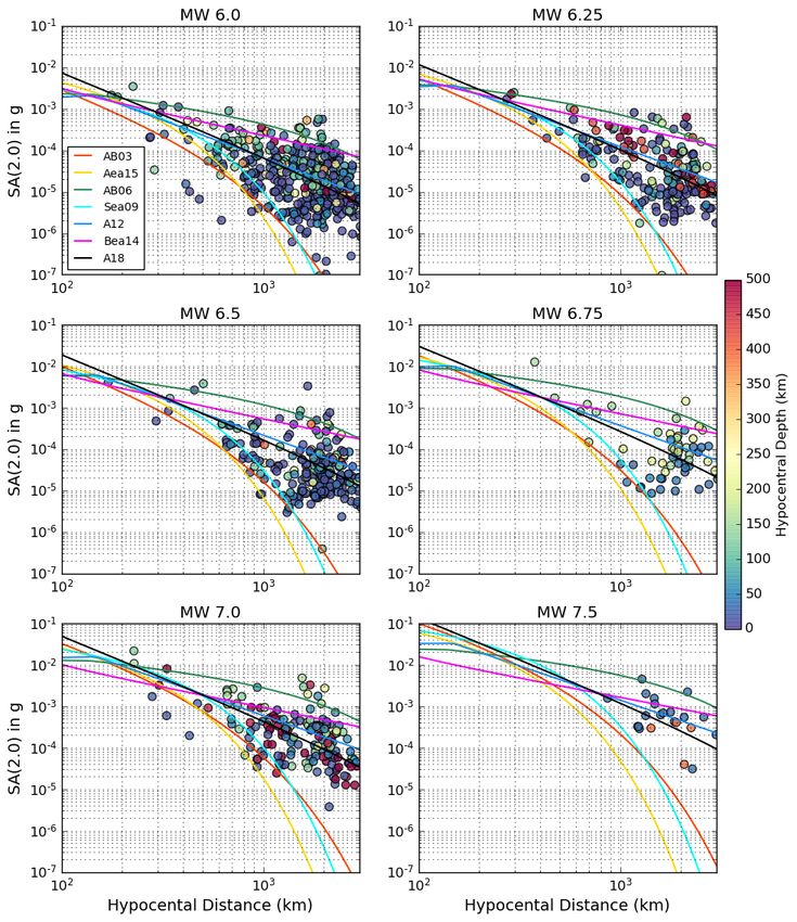
Wetar backarc thrust zones (McCaffrey 1996), with recent studies suggesting the Timor Trough continues to
accommodate some of this convergence (Saqab et al. 2017).

Figure 2: An example of a velocity seismogram, recorded at Narrogin (NWAO) during the 16 September
2018 MW 5.3 Lake Muir, southwestern Western Australia earthquake. The station was approximately 170 km
from the earthquake’s epicentre. The record shows a strong Rg phase arrivals at longer periods (indicating
a shallow rupture depth), which is characteristic of seismic recordings from this region.

Ground-motions generated from earthquakes on these sources have particular significance for northern
Australian communities and infrastructure projects, with several large earthquakes in the Banda Arc region
having caused ground shaking-related damage in Darwin over the historical period (Hearn & Webb 1984;
McCue 2013). There are very few regions of the world where cold cratonic crust abuts a convergent tectonic
margin with subduction earthquakes. Most ground-motions recorded from earthquakes in typical subduction
environments are highly attenuated as they travel through volcanic back-arc regions (e.g., Ghofrani &
Atkinson 2011). However, seismic energy from earthquakes in the northern Australian plate margin region
are efficiently channelled through the low-attenuation NAC (Fishwick et al. 2005; Wei et al. 2017), which
acts as a waveguide for high-frequency earthquake shaking (Kennett & Furumura 2008). The low rate of
attenuation means that choosing ground-motion models for these subduction earthquakes that reflect both the
earthquake source and attenuation characteristics of the region is a major challenge in PSHAs. For the
NSHA18, a mélange of GMMs from different tectonic environments were applied to model ground motions
from earthquakes in this environment. Subsequent analysis of recorded data from earthquakes in the region
suggests that several of the selected GMMs tend to underestimate recorded ground motions from large (MW ≥
6.0) offshore plate boundary earthquakes (Figure 3). No one model performs well across all spectral periods.
This demonstrates the need to develop new GMMs that are appropriate for the unique tectonic environment
in northern Australia for application in future national-scale and site-specific seismic hazard assessments.
There is still much to do in terms of characterising ground-motions from Australian earthquakes for use in
seismic hazard assessments, particularly due to the sparse recording networks and low rates of seismicity.
However, knowledge in the character of ground-motion attenuation throughout the country is gradually
evolving and recent successes, such as the rapid deployment of aftershock equipment following the
16 September 2018 MW 5.3 Lake Muir, Western Australia earthquake, have yielded quality near-source data
for other moderate-magnitude earthquakes (up to MW 5.2) from the sequence. These data will have
significant utility to enable more informed choices for GMMs for future hazard assessments and will
underpin future empirical and simulated ground-motion studies for the nation. Ongoing enhancements to
seismic monitoring networks also provide opportunities to augment existing ground-motion datasets.

Paper 392 – Seismic hazard estimation in stable continental regions: challenges and opportunities
2019 Pacific Conference on Earthquake Engineering and Annual NZSEE Conference                             5
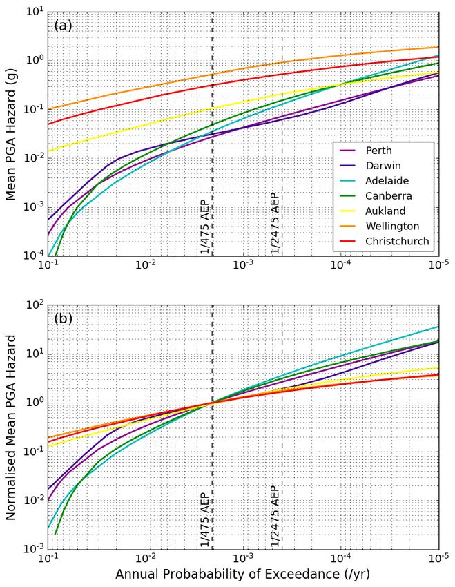
Figure 3: Recorded spectral accelerations (Sa) at 2.0 seconds at Australian sites from earthquakes
occurring in the Sunda-Banda Arc region. Data are binned in 0.25-magnitude unit bins and are compared to
GMMs nominated for use in the NSHA18 for the plate margin region for a rock site class: i.e., Atkinson &
Boore (2003; AB03; intraslab);Abrahamson et al. (2016; Aea16; intraslab); Atkinson & Boore (2006;
AB06; eastern US); Somerville et al. (2009; Sea09; Australia non-cratonic); Allen (2012; A12; southeastern
Australia), and; Boore et al. (2014; Bea14; active crust). The A18 model refers to a “far-field” GMM in
development at Geoscience Australia. Observations are colour-coded by the earthquake’s hypocentral depth.

5   SEISMIC SOURCE CHARACTERISATION
Alternative seismic source models combined through a logic-tree approach are often used in PSHA to
capture the epistemic uncertainty of multiple scientifically defensible alternatives (e.g., Bommer 2012). The
calculated ground-motion hazard can be very sensitive to the location of classical area-source-model
boundaries (Leonard et al. 2014). The placement of these boundaries is often subjective and can be
dependent on the modeller’s professional judgment and experience. Furthermore, if the modeller only
considers one zone-based seismic-source model, the strongest hazard gradients will often tend to occur in the
vicinity of the area source boundaries. Because the area-source boundaries developed by two (or more)

Paper 392 – Seismic hazard estimation in stable continental regions: challenges and opportunities
2019 Pacific Conference on Earthquake Engineering and Annual NZSEE Conference                              6
independent modellers are unlikely to be duplicated exactly, the use of multiple seismic source models will
introduce “fuzzy” source-zone boundaries and will act to damp these strong spatial hazard gradients. In the
NSHA18, five different seismic source-model classes were used (Allen et al. 2018a). These include:
• Background area source zones that use broad geographic zones within which large earthquakes can occur
anywhere with equal probability. These are typically models with 20 or fewer area-source zones on a
national scale;
• Regional area source zones that assume the spatial distribution of seismicity is non-uniform at the scale
of background source zones and that the distribution of historical seismicity is useful to forecast future
earthquake occurrence. These are typically models with 30 or more area sources;
• Seismotectonic models (e.g., regional zones combined with a fault-source model; Clark et al. 2016);
• Smoothed seismicity data-driven models that yield spatially-varying earthquake occurrence rates by
smoothing the observed rates of earthquake occurrence with a given smoothing kernel (e.g., Frankel
1995). These models assume that historical seismicity is a good predictor of future seismic hazard;
• Smoothed seismicity combined with a fault-source model.
The latter two source-model types represent minor variations on the regional and smoothed seismicity
models. In total, the NSHA18 used 19 independent seismic source models for estimating the rates of
earthquake occurrence at any given location in continental Australia (Allen et al. 2018a). These source
models were weighted through a logic-tree framework (Griffin et al. 2018) and each provide a unique spatial
representation of hazard (Figure 4). As demonstrated in Figure 4, the consequence of using background
source models (Figure 4a) may lead to lower seismic hazard values where seismicity has been relatively
stationary in the instrumental era (Leonard 2008) (Figure 4b-c). This raises questions over the
appropriateness of including background zones for some areas such as the Flinders Ranges, the Latrobe
Valley and the eastern highlands regions, where a century of historical data suggests seismicity in these
regions is relatively stationary in space and time (Leonard 2008).
Figure 4: The mean 10% in 50-year PGA hazard expressed by three end-member source model types as used
in the NSHA18: a) broad background zones (NSHM12; Leonard et al. 2012); b) regional area sources
(NSHM12; Leonard et al. 2012), and; c) smoothed seismicity (GA Fixed Kernel; Griffin et al. 2017).
One challenge for forecasting seismic hazard for SCRs is the long recurrence times for large earthquakes.
While the use of background source models may need to be reconsidered for eastern Australia, there is
mounting evidence in central and western Australia to suggest that seismicity is non-stationary over time and
could vary over decade-long timescales (Leonard 2008; Clark et al. 2012; Clark & Allen 2018). Therefore,
Paper 392 – Seismic hazard estimation in stable continental regions: challenges and opportunities
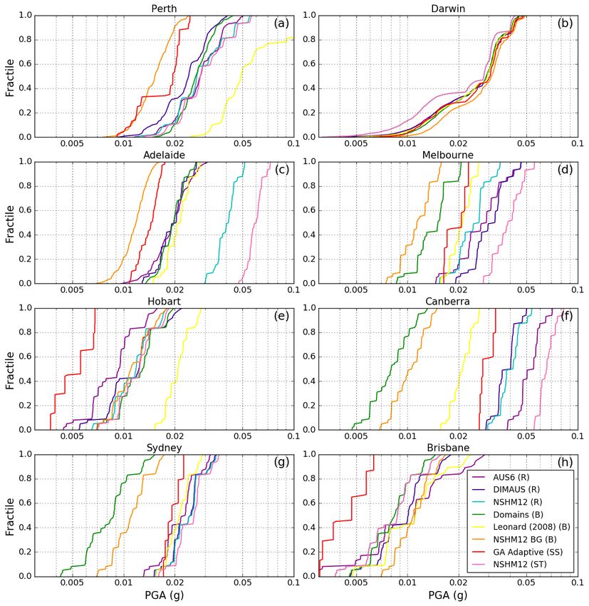
2019 Pacific Conference on Earthquake Engineering and Annual NZSEE Conference 7the use of background source models that allow for large earthquakes to migrate spatially over longer timescales may become more important. Hazard modellers must therefore strike a balance between these end-member models when calculating seismic hazard at national scales. Furthermore, the relative weight placed on a specific model type (e.g., smoothed seismicity, regional or background) might vary spatially, and also on the target return period of interest (e.g., Woessner et al. 2015). 6 QUANTIFYING MODELLING UNCERTAINTY In developing national-scale PSHAs, the mean hazard is commonly presented with little attention given to the range of potential end-member solutions. This ensemble of solutions arises through the use of weighted logic-tree distributions based on the decisions of seismic-hazard modellers to consider alternative source and ground-motion models. End users often perceive the mean results from PSHAs to be an accurate representation of reality (Lee et al. 2018). However, it is becoming increasingly important to communicate the mean hazard results from PSHAs in the context of their uncertainties. This ensures that hazard assessments are both transparent and defensible to end users and the wider seismological community (Stein et al. 2012; Douglas et al. 2014). Exploring these modelling uncertainties can improve our understanding of the sensitivities of seismic hazard to specific choices made though the modelling process. To provide a sense of the relative contribution of each source-model type to a national-scale PSHA, the 0th to 100th hazard fractiles for eight representative NSHA18 seismic-source models are calculated and plotted as cumulative density functions (CDFs). Figure 5 shows the spread of uncertainty in seismic hazard both within and between the candidate seismic-source models for the Australian capital cities. There is comparatively little epistemic uncertainty between the source models for Darwin (Figure 5b) because the hazard is driven by the plate margin seismic source model (Griffin & Davies 2018), which is common between all source models. For the eastern capital cities (e.g., Canberra, Melbourne and Sydney), the background and regional source model CDFs tend to cluster in their respective model classes, with the regional models typically forecasting larger ground motions than the background models at the 10% probability of exceedance in 50-year level. The between-model variability for Canberra (Figure 5f), in particular, shows significant disparities between the background and regional source models. Given the relatively high and steady rate of seismicity in the Canberra region, the use of background seismic source models that envelope Canberra and characterize the chance of random earthquakes occurring anywhere within a broad tectonically analogous region, may have limited applicability. Consequently, it is recommended that for future national-scale hazard assessments for Australia, that the consequences of choices made during the expert elicitation process (Griffin et al. 2018) be reviewed prior to finalising the hazard model. The primary limitation to this approach, however, is that the experts may prejudice their responses to achieve specific outcomes. The benefits of this approach therefore need to be balanced against the potential for undermining the original intent for the expert elicitation. 7 SHAPE OF HAZARD CURVES One of the major differences in seismic hazard between active tectonic regions (ATRs) and SCRs is how the shape of the hazard curve changes with decreasing probabilities of exceedance. Figure 6 shows a comparison of seismic hazard curves for selected Australian sites as calculated in the NSHA18 relative to hazard curves from a recent assessment of seismic hazard for sites in New Zealand (Abbott et al. 2019, in prep.). By normalising the curves to an arbitrary exceedance probability (Figure 6b), the difference in the rate of change of the hazard curves between the SCR and the New Zealand ATR sites is more clearly expressed, with the hazard for a typical Australian site increasing at a much faster rate at low probabilities (or longer return periods) than typical sites in New Zealand. This is a common feature found in other hazard assessments that consider both SCRs and ATRs (e.g., Leyendecker et al. 2000). Paper 392 – Seismic hazard estimation in stable continental regions: challenges and opportunities 2019 Pacific Conference on Earthquake Engineering and Annual NZSEE Conference 8
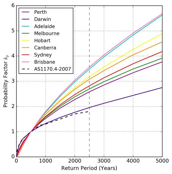
Figure 5: Cumulative density functions between representative regional (R), background (B), smoothed
seismicity (SS) and seismotectonic (ST) seismic source models used in the NSHA18. The CDFs indicate the
PGA ground-motion for a 10% exceedance probability in 50 years for Australian capital cities and show the
variation in uncertainties both within and between the candidate seismic source models. Note that not all of
the models represented above receive equal weighing in the final source model logic tree (Allen et al. 2018a;
Griffin et al. 2018).

While the current design probability in Australia for ordinary-use structures is 1/500 annual exceedance
probability (AEP), it is necessary to scale seismic hazard to different ground-motion return periods for the
design of high-importance structures, in particular. In the AS1170.4–2007, this is achieved using the
probability factor (kp), which is equivalent to the return period factor RS or RU in the NZS 1170.5–2004
(Standards New Zealand 2004). The AS1170.4–2007 uses the same factors as defined in the NZS 1170.5–
2004. The kp factor is calculated by normalising the hazard curve by its value at a recurrence interval of 500
years. As with the 2012 National Seismic Hazard Maps (NSHM12; Burbidge 2012; Leonard et al. 2013), the
kp factors derived from the NSHA18 differ markedly from those factors given in the current Standard, with a
national average of kp = 3.15 at the 1/2500 AEP, compared to kp = 1.8 in the AS1170.4–2007.

Paper 392 – Seismic hazard estimation in stable continental regions: challenges and opportunities
2019 Pacific Conference on Earthquake Engineering and Annual NZSEE Conference                               9
Figure 6: Top panel (a) show NSHA18 PGA hazard curves for representative Australian (Perth, Darwin,
Adelaide and Canberra) and New Zealand (Auckland, Wellington and Christchurch) cities. Bottom panel (b)
shows the same hazard curves normalised at the 1/475 AEP to emphasise rate of change of hazard curves
between Australian (SRC) and New Zealand (ATR) localities.

Figure 7 shows the comparison of kp factors for the eight capital cities across Australia. It is clear that there is
a large variation in the kp factors among these localities. Differences in kp factors between localities expresses
the difference in the shape of the seismic hazard curve (e.g., Figure 6). In seismically active regions,
moderate-level ground shaking has a higher chance of being exceeded than in SCRs. Sites in SCRs with low
1/500 AEP hazard will start from a lower base level (e.g., Brisbane). Consequently, kp factors will rise more
rapidly when rare events occur because the 1/500 hazard levels will be more easily exceeded over longer
return periods. However, this explanation does not hold true for sites affected by seismogenic faults, such as
Adelaide. The kp factors for Adelaide are among the highest because of the nearby fault sources, which do
not contribute significantly to the hazard at the 1/500 AEP due to their long recurrence intervals (Clark et al.
2016). However, these fault sources will tend to contribute proportionately more to seismic hazard at higher
return periods, as is demonstrated for the kp curve for Adelaide.
The kp curve for Darwin appears to mimic the factors in the AS1170.4–2007, which were derived from the
factors determined for tectonically active New Zealand (Standards New Zealand 2004). The dominant
sources of hazard to Darwin are the plate margin earthquakes off northern Australia (i.e., Griffin & Davies
2018). Because these sources occur in ATRs, northern Australian sites are likely to exceeded moderate levels
of ground shaking with shorter return intervals. Consequently, the hazard increase at lower probabilities of

Paper 392 – Seismic hazard estimation in stable continental regions: challenges and opportunities
2019 Pacific Conference on Earthquake Engineering and Annual NZSEE Conference                                    10
exceedance for Darwin occurs at a slower rate relative to typical SCR sites, where the hazard contribution of
large rare earthquakes leads to faster increases in seismic hazard for decreasing probabilities of occurrence
(e.g., Leyendecker et al. 2000; Nordenson & Bell 2000). This suggests the need for site-specific hazard
scaling for different return periods for future seismic design provisions.

Figure 7: The PGA probability factor (kp) for the eight capital cities compared to the kp values in AS1170.4–
2007. The factors are calibrated such that kp = 1.0 for a 1/500 AEP. The thin vertical dashed line indicates a
ground-motion return period with an annual exceedance probability of 1/2500.

The commentary above focusses on hazard expressed in terms of PGA. A recent paper by Allen & Luco
(2018) discusses further opportunities to update building provisions for Australia by considering the adoption
of uniform hazard spectra, which unlike the fixed spectral shape in the AS1170.4–2007, offers uniform
hazard estimates across all oscillation periods at all localities (e.g., McGuire 1977).

8   CONSIDERATIONS FOR FUTURE BUILDING PROVISIONS
The selection of the 10% exceedance probability in 50 years for the first United States (US) National Seismic
Hazard Maps was originally a rather arbitrary decision and appeared to be a “reasonable” choice to ensure
structures “remain operable” following large earthquakes (Algermissen & Perkins 1976). This probability
level was generally viewed to be appropriate for the average recurrence of large damaging earthquakes in
well-studied ATRs such as California, and was also considered suitable for collapse prevention. Given that
this was best practice for the time, this exceedance probability was also adopted by the National
Construction Code of Australia (e.g., Australian Building Codes Board 2016) for use in the first edition of
the AS1170.4–1993 (Standards Australia 1993).
However, in the late 1990s, concerns were raised by engineers and seismologists in the US that anchoring
design hazard values to 1/475 AEP would result in significant disparities in the seismic performance of
ordinary-use structures across the country, with regions of low-to-moderate levels of seismicity being
considerably more at risk to extreme ground-motion events (e.g., Nordenson & Bell 2000; Federal
Emergency Management Agency 2004; Wilson et al. 2008). These concerns led to the adoption of seismic
design ground-motion demands for a 2% probability of exceedance in 50 years (1/2475 AEP) for the
International Building Code developed in the US. This change in the exceedance probability level was

Paper 392 – Seismic hazard estimation in stable continental regions: challenges and opportunities
2019 Pacific Conference on Earthquake Engineering and Annual NZSEE Conference                              11
adopted in the National Building Code of Canada (NBCC) shortly thereafter (Heidebrecht 2003). The 1/2475
AEP level is thought to more closely relate to the probability of structural collapse for regular structures
(Bommer & Pinho 2006). The adoption of this ground-motion exceedance probability leads to several
advantages:
In low-to-moderate seismicity regions, there is a larger difference between 1/475 and 1/2475 AEP ground-
motions than in more tectonically active regions (e.g., Allen & Luco 2018). Transitioning to lower
exceedance probabilities in the national design provisions reduces the risk in low-to-moderate seismicity
regions due to rare extreme ground motions (Leyendecker et al. 2000);
The rate of attenuation of earthquake ground-shaking is generally lower in stable continental regions
(SCRs) like Australia (e.g., Frankel et al. 1990; Bakun & McGarr 2002). Thus, these provisions protect
against rare events that have the potential to affect larger areas than in tectonically active regions;
Structures in low-to-moderate seismicity regions would be designed with more comparable seismic
resistance (combined strength and ductility) to structures in high seismicity regions;
In many cases, effective seismic resistance for new construction can be achieved at minimal incremental
cost (Nordenson & Bell 2000).
Australia has much in common in terms of the vintage of urban development and tectonic setting with
eastern North America (e.g., Bairoch & Goertz 1986). Given that both Canada and the United States have
recognised that 10% probability of exceedance in 50 years does not provide seismic protection to extreme
ground motions from rare events in their low-seismicity settings, it would seem sensible that Australia too,
should review appropriateness of the probability levels currently required for ordinary-use structures by the
National Construction Code. This is underscored by the significant reductions in its seismic hazard forecasts
at the 1/500 AEP through the NSHA18 (Allen et al. 2018a).
In general terms, a 1/500 AEP means that in any 50-year period, we should expect approximately 10% of the
Australian continental landmass to experience shaking exceeding mapped values (e.g., Ward 1995; Allen et
al. 2009; Vanneste et al. 2018). This exceedance level is approximately equivalent to a fractional area
equivalent to the state of New South Wales. As earthquake scientists and engineers, it is reasonable to ask
whether this exceedance probability level is acceptable. The AS1170.4–2007 (R2018) (Standards Australia
2018) uses the original AS1170.4–1993 seismic hazard factors, but now requires a minimum design PGA
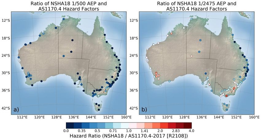
level of 0.08 g. Figure 8 maps the ratio of the NSHA18 1/500 and 1/2475 AEP PGA values relative to the
AS1170.4–2007 (R2018) values. If we assume a 1/500 AEP is appropriate for design and construction in
Australia, a pragmatist might argue that if the current provisions are adequate for all localities (Figure 8a).
Therefore, there would be little-to-no risk in not updating the underlying hazard maps with the modern
hazard estimates. However, this all depends on whether we, as a community, are comfortable with the 10%
in 50-year exceedance level. If the response is “no”, and we now compare the existing provisions required
for ordinary-use structures with the NSHA18 1/2475 AEP PGA values, we see that there are now several
localities where the lower-probability seismic hazard exceeds that of the current design provisions
(Figure 8b). Critically, some of these localities include major urban centres of Canberra, Melbourne and
Adelaide, as well as strategically important localities such as Morwell in the Latrobe Valley (Victoria) and
Port Hedland off the northwest shelf (Western Australia). Therefore, these localities could be vulnerable to
ground-motions from extreme events. In line with the AS1170.4–2007 amendment adopted in 2018,
minimum base shear design values could apply for the remaining low-hazard jurisdictions (e.g., Humar
2015). Consequently, any considerations for updating future design provisions in Australia should carefully
consider the seismic design probability required for ordinary-use structures and whether these design levels
meet community expectations for seismic safety.
Paper 392 – Seismic hazard estimation in stable continental regions: challenges and opportunities
2019 Pacific Conference on Earthquake Engineering and Annual NZSEE Conference 129 CONCLUSIONS This contribution discusses some of the challenges facing seismic hazard analysis in SCRs, with emphasis on Australia. In particular, challenges relating to completeness and quality earthquake catalogues, ground- motion and seismic source model characterisation and their influence on seismic hazard estimates are discussed. While many of these challenges will require ongoing monitoring and research, there are several opportunities to improve seismic hazard estimation by utilising existing datasets and methods. However, philosophical challenges will remain in terms of how to best model seismic hazard at different spatial scales for varying return periods of interest. In the face of these uncertainties, there are still opportunities to advance earthquake hazard science for SCRs to improve building provisions and these should be prioritised to improve seismic safety within our communities and to secure major infrastructure assets. 53B Figure 8: Comparison of seismic hazard design factors at AS1170.4 localities illustrating a) the ratio of NSHA18 1/500 AEP PGA relative to the AS1170.4-2007 [R2018] and b) the ratio of NSHA18 1/2475 AEP PGA relative to the AS1170.4-2007 [R2018] hazard design factors. 10 ACKNOWLEDGEMENTS The author would like to acknowledge the various contributions to these ideas from the NSHA18 team at Geoscience Australia (Jonathan Griffin, Mark Leonard, Dan Clark and Hadi Ghasemi). Discussions with Tuna Onur have been helpful in framing this discussion. Elizabeth Abbott and Matt Gerstenberger are thanked for supplying seismic hazard information for key localities in New Zealand. Hadi Ghasemi and an anonymous reviewer are thanks for their thoughtful comments to this manuscript. Finally, this manuscript is published with the permission of the CEO of Geoscience Australia (eCat: 126625). 11 REFERENCES Abbott, E.R., Gerstenberger, M.C., Horspool, N., Huso, R., Rhoades, D., Van Houtte, C., McVerry, G.H. & Canessa, S. 2019, in prep. Hazard and risk in New Zealand using OpenQuake. Earthq. Spectra. Abrahamson, N., Gregor, N. & Addo, K. 2016. BC Hydro ground motion prediction equations for subduction earthquakes. Earthq. Spectra, Vol 32(1): 23-44, doi: 10.1193/051712EQS188MR. Al Atik, L., Abrahamson, N., Bommer, J.J., Scherbaum, F., Cotton, F. & Kuehn, N. 2010. The variability of ground- motion prediction models and its components. Seism. Res. Lett., Vol 81(5): 794-801, doi: 10.1785/gssrl.81.5.794. Paper 392 – Seismic hazard estimation in stable continental regions: challenges and opportunities 2019 Pacific Conference on Earthquake Engineering and Annual NZSEE Conference 13
Algermissen, S.T. & Perkins, D.M. 1976. A probabilistic estimate of maximum accelerations in rock in the contiguous
  United States. US Geological Survey, Open-File Report 76-416.
Allen, T., Griffin, J., Leonard, M., Clark, D. & Ghasemi, H. 2018a. The 2018 National Seismic Hazard Assessment for
   Australia: model overview. Geoscience Australia, Record 2018/27, Canberra, 126 pp, doi: 10.11636/Record.2018.027.
Allen, T.I. 2010. The influence of attenuation in earthquake ground-motion and magnitude estimation: implications for
   Australian earthquake hazard. Australian Earthquake Engineering Society 2010 Conference, Perth, Western Australia.
Allen, T.I. 2012. Stochastic ground-motion prediction equations for southeastern Australian earthquakes using updated
   source and attenuation parameters. Geoscience Australia, Record 2012/69, Canberra, 55 pp.
Allen, T.I., Cummins, P.R., Dhu, T. & Schneider, J.F. 2007. Attenuation of ground-motion spectral amplitudes in
   southeastern Australia. Bull. Seism. Soc. Am., Vol 97(4): 1279–1292, doi: 10.1785/0120060172
Allen, T.I., Leonard, M., Ghasemi, H. & Gibson, G. 2018b. The 2018 National Seismic Hazard Assessment for Australia:
   earthquake epicentre catalogue. Geoscience Australia, Record 2018/30, Canberra, doi: 10.11636/Record.2018.030.
Allen, T.I. & Luco, N. 2018. Opportunities to enhance seismic demand parameters for future editions of the AS1170.4.
   Australian Earthquake Engineering Society 2018 Conference, Perth, Western Australia.
Allen, T.I., Wald, D.J., Earle, P.S., Marano, K.D., Hotovec, A.J., Lin, K. & Hearne, M. 2009. An Atlas of ShakeMaps
   and population exposure catalog for earthquake loss modeling. Bull. Earthq. Eng., Vol 7(3): 701-718, doi:
   10.1007/s10518-009-9120-y.
Atkinson, G.M. & Boore, D.M. 2003. Empirical ground-motion relations for subduction-zone earthquakes and their
  application to Cascadia and other regions. Bull. Seism. Soc. Am., Vol 93(4): 1703-1729, doi: 10.1785/0120020156.
Atkinson, G.M. & Boore, D.M. 2006. Earthquake ground-motion prediction equations for eastern North America. Bull.
  Seism. Soc. Am., Vol 96: 2181-2205, doi: 10.1785/0120050245.
Australian Building Codes Board 2016. National Construction Code of Australia: Volume One Amendment 1.
Bairoch, P. & Goertz, G. 1986. Factors of urbanisation in the nineteenth century developed countries: a descriptive and
  econometric analysis. Urban Stud., Vol 23(4): 285-305, doi: 10.1080/00420988620080351.
Bakun, W.H. & McGarr, A. 2002. Differences in attenuation among the stable continental regions. Geophys. Res. Lett.,
  Vol 29(23): 2121, doi:10.1029/2002GL015457.
Bommer, J.J. 2012. Challenges of building logic trees for probabilistic seismic hazard analysis. Earthq. Spectra, Vol
  28(4): 1723-1735, doi: 10.1193/1.4000079.
Bommer, J.J. & Abrahamson, N.A. 2006. Why do modern probabilistic seismic-hazard analyses often lead to increased
  hazard estimates? Bull. Seism. Soc. Am., Vol 96(6): 1967–1977, doi: 10.1785/0120060043.
Bommer, J.J. & Pinho, R. 2006. Adapting earthquake actions in Eurocode 8 for performance-based seismic design.
  Earthq. Eng. Struct. D., Vol 35: 39-55, doi: 10.1002/eqe.530.
Boore, D.M., Stewart, J.P., Seyhan, E. & Atkinson, G.M. 2014. NGA-West 2 equations for predicting PGA, PGV, and
  5%-damped PSA for shallow crustal earthquakes. Earthq. Spectra, Vol 30(3): 1057-1085, doi:
  10.1193/070113EQS184M.
Burbidge, D.R. (Editor), 2012. The 2012 Australian Earthquake Hazard Map. Geoscience Australia Record 2012/71, 116
  pp.
Clark, D. & Allen, T. 2018. What have we learnt of cratonic earthquakes in the fifty years since Meckering? Australian
  Earthquake Engineering Society 2018 Conference, Perth, Western Australia.
Clark, D. & Leonard, M. 2014. Regional variations in neotectonic fault behaviour in Australia, as they pertain to the
  seismic hazard in capital cities. Australian Earthquake Engineering Society 2014 Conference, Lorne, Victoria.
Clark, D., Leonard, M., Griffin, J., Stirling, M. & Volti, T. 2016. Incorporating fault sources into the Australian National
  Seismic Hazard Assessment (NSHA) 2018. Australian Earthquake Engineering Society 2016 Conference, Melbourne,
  Victoria.
Clark, D., McPherson, A. & Van Dissen, R. 2012. Long-term behaviour of Australian stable continental region (SCR)
  faults. Tectonophys., Vol 566-567: 1-30, doi: 10.1016/j.tecto.2012.07.004.
Denham, D., Alexander, L.G. & Worotnicki, G. 1980. The stress field near the sites of the Meckering (1968) and Calingiri
  (1970) earthquakes, Western Australia. Tectonophys., Vol 67: 283-317.
Douglas, J. 2018. Ground motion prediction equations 1964-2018. Department of Civil and Environmental Engineering,
  University of Strathclyde, July 2018, 624 pp.

Paper 392 – Seismic hazard estimation in stable continental regions: challenges and opportunities
2019 Pacific Conference on Earthquake Engineering and Annual NZSEE Conference                                           14
Douglas, J., Ulrich, T., Bertil, D. & Rey, J. 2014. Comparison of the ranges of uncertainty captured in different seismic-
  hazard studies. Seism. Res. Lett., Vol 85(5): 977-985, doi: 10.1785/0220140084.
Drummond, B.J., Goleby, B.R. & Swager, C.P. 2000. Crustal signature of Late Archaean tectonic episodes in the Yilgarn
  craton, Western Australia: evidence from deep seismic sounding. Tectonophys., Vol 329: 193-221.
Federal Emergency Management Agency 2004. NEHRP Recommended Provisions for seismic regulations for new
  buildings and other structures, Part 2: Commentary. Federal Emergency Management Agency 450-2 / 2003 Edition,
  Washington, D.C., 385 pp.
Fishwick, S., Kennett, B.L.N. & Reading, A.M. 2005. Contrasts in lithospheric structure within the Australian craton—
   insights from surface wave tomography. Earth Planet. Sci. Lett., Vol 231: 163– 176, doi: 10.1016/j.epsl.2005.01.009.
Frankel, A. 1995. Mapping seismic hazard in the central and eastern United States. Seism. Res. Lett., Vol 66(4): 8-21, doi:
   10.1785/gssrl.66.4.8.
Frankel, A., McGarr, A., Bicknell, J., Mori, J., Seeber, L. & Cranswick, E. 1990. Attenuation of high-frequency shear
   waves in the crust: measurements from New York State, South Africa, and southern California. J. Geophys. Res., Vol
   95(B11): 17,441-17,457, doi: 10.1029/JB095iB11p17441.
Ghasemi, H. & Allen, T. 2017. Testing the sensitivity of new Australian empirical magnitude conversion equations on
  seismic hazard analyses. Australian Earthquake Engineering Society 2017 Conference, Canberra, ACT.
Ghasemi, H. & Allen, T.I. 2018. Selection and ranking of ground-motion models for the 2018 National Seismic Hazard
  Assessment of Australia: summary of ground-motion data, methodology and outcomes. Geoscience Australia, Record
  2018/29, Canberra, 29 pp, doi: 10.11636/Record.2018.029.
Ghofrani, H. & Atkinson, G.M. 2011. Forearc versus backarc attenuation of earthquake ground motion. Bull. Seism. Soc.
  Am., Vol 101(6): 3032–3045, doi: 10.1785/0120110067.
Goulet, C., Bozorgnia, Y., Abrahamson, N., Kuehn, N., Al Atik, L., Youngs, R., Graves, R. & Atkinson, G. 2018. Central
  and eastern North America ground-motion characterization: NGA-East final report. Pacific Earthquake Engineering
  Research Center, PEER Report No. 2018/08, University of California, Berkeley.
Griffin, J. & Davies, G. 2018. Earthquake sources of the Australian plate margin: revised models for the 2018 national
  tsunami and earthquake hazard assessments. Geoscience Australia, Record 2018/31, Canberra, 37 pp, doi:
  10.11636/Record.2018.031.
Griffin, J., Gerstenberger, M., Allen, T., Clark, D., Cummins, P., Cuthbertson, R., Dimas, V.-A., Gibson, G., Ghasemi,
  H., Hoult, R., Lam, N., Leonard, M., Mote, T., Quigley, M., Somerville, P., Sinadinovski, C., Stirling, M. &
  Venkatesan, S. 2018. Expert elicitation of model parameters for the 2018 National Seismic Hazard Assessment:
  Summary of workshop, methodology and outcomes. Geoscience Australia, Record 2018/28, Canberra, 74 pp, doi:
  10.11636/Record.2018.028.
Griffin, J., Volti, T., Clark, D., Ghasemi, H., Leonard, M. & Allen, T. 2016. Development of the 2018 Australian National
  Seismic Hazard Assessment (NSHA). Australian Earthquake Engineering Society 2016 Conference, Melbourne,
  Victoria.
Griffin, J., Weatherill, G. & Allen, T. 2017. Performance of national scale smoothed seismicity estimates of earthquake
  activity rates. Australian Earthquake Engineering Society 2017 Conference, Canberra, ACT.
Gutenberg, B. & Richter, C.F. 1944. Frequency of earthquakes in California. Bull. Seism. Soc. Am., Vol 34(4): 185-188.
Hearn, S.J. & Webb, J.P. 1984. Continental-scale felt effects of the large Banda Sea earthquake of 4 November 1963.
  Bull. Seism. Soc. Am., Vol 74(1): 349-351.
Heidebrecht, A.C. 2003. Overview of seismic provisions of the proposed 2005 edition of the National Building Code of
  Canada. Can. J. Civ. Eng., Vol 30(2): 241-254, doi: 10.1139/l02-068.
Hejrani, B. & Tkalčić, H. 2018. The 20 May 2016 Petermann Ranges earthquake: centroid location, magnitude and focal
  mechanism from full waveform modelling. Aust. J. Earth. Sci., doi: 10.1080/08120099.2018.1525783.
Humar, J. 2015. Background to some of the seismic design provisions of the 2015 National Building Code of Canada.
  Can. J. Civ. Eng., Vol 42: 940–952, doi: 10.1139/cjce-2014-0385.
Kennett, B.L.N. & Furumura, T. 2008. Stochastic waveguide in the lithosphere: Indonesian subduction zone to Australian
  craton. Geophys. J. Int., Vol 172: 363–382, doi: 10.1111/j.1365-246X.2007.03647.x.
King, T.R., Quigley, M.C. & Clark, D. 2018. Earthquake environmental effects produced by the MW 6.1, 20th May 2016
  Petermann earthquake, Australia. Tectonophys., Vol 747-748: 357–372, doi: 10.1016/j.tecto.2018.10.010.
Lee, Y., Graf, W. & Hu, Z. 2018. Characterizing the epistemic uncertainty in the USGS 2014 National Seismic Hazard

Paper 392 – Seismic hazard estimation in stable continental regions: challenges and opportunities
2019 Pacific Conference on Earthquake Engineering and Annual NZSEE Conference                                          15
Mapping Project (NSHMP) Bull. Seism. Soc. Am., Vol 108(3A): 1465-1480, doi: 10.1785/0120170338.
Leonard, M. 2008. One hundred years of earthquake recording in Australia. Bull. Seism. Soc. Am., Vol 98(3): 1458–1470,
  doi: 10.1785/0120050193.
Leonard, M., Burbidge, D. & Edwards, M. 2013. Atlas of seismic hazard maps of Australia: seismic hazard maps, hazard
  curves and hazard spectra. Geoscience Australia Record 2013/41, 39 pp.
Leonard, M., Burbidge, D.R., Allen, T.I., Robinson, D.J., McPherson, A., Clark, D. & Collins, C.D.N. 2014. The
  challenges of probabilistic seismic-hazard assessment in stable continental interiors: an Australian example. Bull.
  Seism. Soc. Am., Vol 104(6): 3008-3028, doi: 10.1785/0120130248.
Leonard, M., McPherson, A. & Clark, D. 2012. Source zonation. In: D.R. Burbidge (Editor), The 2012 Australian
  Earthquake Hazard Map, 27-43.
Leyendecker, E.V., Hunt, R.J., Frankel, A.D. & Rukstales, K.S. 2000. Development of maximum considered earthquake
  ground motion maps. Earthq. Spectra, Vol 16(1): 21-40, doi: 10.1193/1.1586081.
Liang, J.Z., Hao, H., Gaull, B.A. & Sinadinovski, C. 2008. Estimation of strong ground motions in southwest Western
   Australia with a combined Green's function and stochastic approach. J. Earthq. Eng., Vol 12(3): 382–405, doi:
   10.1080/13632460701568607.
McCaffrey, R. 1996. Slip partitioning at convergent plate boundaries of SE Asia. Geol. Soc. London Spec. Publ., Vol
  106: 3-18, doi: 10.1144/GSL.SP.1996.106.01.02.
McCue, K. 2013. Darwin Northern Territory – an earthquake hazard. Australian Earthquake Engineering Society 2013
  Conference, Hobart, Tasmania.
McGuire, R.K. 1977. Seismic design spectra and mapping procedures using hazard analysis based directly on oscillator
  response. Earthq. Eng. Struct. D., Vol 5(3): 211–234, doi: 10.1002/eqe.4290050302.
Michael-Leiba, M. & Malafant, K. 1992. A new local magnitude scale for southeastern Australia. BMR J. Aust. Geol.
  Geophys., Vol 13(3): 201-205.
Nordenson, G.J.P. & Bell, G.R. 2000. Seismic design requirements for regions of moderate seismicity. Earthq. Spectra,
  Vol 16(1): 205-225, doi: 10.1193/1.1586091.
Richter, C.F. 1935. An instrumental earthquake magnitude scale. Bull. Seism. Soc. Am., Vol 25(1): 1-32.
Saqab, M.M., Bourget, J., Trotter, J. & Keep, M. 2017. Newconstraints on the timing of flexural deformation along the
  northern Australian margin: Implications for arc-continent collision and the development of the Timor Trough.
  Tectonophys., Vol 696–697: 14-36, doi: 10.1016/j.tecto.2016.12.020.
Scherbaum, F., Delavaud, E. & Riggelsen, C. 2009. Model selection in seismic hazard analysis: an information-theoretic
  perspective. Bull. Seism. Soc. Am., Vol 99(6): 3234–3247, doi: 10.1785/0120080347.
Somerville, Quijada, P., Thio, H.K., Sandiford, M. & Quigley, M. 2008. Contribution of identified active faults to near
  fault seismic hazard in the Flinders Ranges. Australian Earthquake Engineering 2008 Conference, Ballarat, Victoria.
Somerville, P., Graves, R., Collins, N., Song, S.-G., Ni, S. & Cummins, P. 2009. Source and ground motion models for
  Australian earthquakes. Australian Earthquake Engineering Society 2009 Conference, Newcastle, New South Wales.
Somerville, P. & Ni, S. 2010. Contrast in seismic wave propagation and ground motion models between cratonic and
  other regions of Australia. Australian Earthquake Engineering Society 2010 Conference, Perth, Western Australia.
Standards Australia 1993. Structural design actions, part 4: Earthquake actions in Australia. Standards Australia, AS
   1170.4–1993, Homebush, NSW.
Standards Australia 2018. Structural design actions, part 4: Earthquake actions in Australia. Standards Australia, AS
   1170.4-2007 (R2018)/Amdt 2-2018, Sydney, NSW.
Standards New Zealand 2004. Structural design actions, part 5: Earthquake actions – New Zealand. Standards New
   Zealand, NZS 1170.5:2004, Wellington, NZ, 76 pp.
Stein, S., Geller, R.J. & Liu, M. 2012. Why earthquake hazard maps often fail and what to do about it. Tectonophys., Vol
   562-563: 1-25, doi: 10.1016/j.tecto.2012.06.047.
Vanneste, K., Stein, S., Camelbeeck, T. & Vleminckx, B. 2018. Insights into earthquake hazard map performance from
  shaking history simulations. Sci. Rep., Vol 8: 1855, doi: 10.1038/s41598-018-20214-6.
Ward, S.N. 1995. Area-based tests of long-term seismic hazard. Bull. Seism. Soc. Am., Vol 85(5): 1285-1298.
Wei, Z., Kennett, B.L.N. & Zhao, L.-F. 2017. Lg-wave attenuation in the Australian crust. Tectonophys., Vol 717: 413-

Paper 392 – Seismic hazard estimation in stable continental regions: challenges and opportunities
2019 Pacific Conference on Earthquake Engineering and Annual NZSEE Conference                                        16
424, doi: 10.1016/j.tecto.2017.08.022.
Wilson, J.L., Lam, N.T.K. & Pham, L. 2008. Development of the New Australian Earthquake Loading Standard. EJSE
  Special Issue, Vol Earthquake Engineering in the low and moderate seismic regions of Southeast Asia and Australia
  (2008): 25-31.
Woessner, J., Danciu, L., Giardini, D., Crowley, H., Cotton, F., Grünthal, G., Valensise, G., Arvidsson, R., Basili, R.,
 Betül Demircioglu, M., Hiemer, S., Meletti, C., Musson, R.W., Rovida, A.N., Sesetyan, K., Stucchi, M. & The SHARE
 Consortium 2015. The 2013 European Seismic Hazard Model: key components and results. Bull. Earthq. Eng., Vol
 13(12): 3553–3596, doi: 10.1007/s10518-015-9795-1.

Paper 392 – Seismic hazard estimation in stable continental regions: challenges and opportunities
2019 Pacific Conference on Earthquake Engineering and Annual NZSEE Conference                                       17
You can also read