Byford Rail Extension - Environmental Scoping Document - EPA WA
←
→
Page content transcription
If your browser does not render page correctly, please read the page content below
Byford Rail Extension
Environmental Scoping Document
January 2021
For more information contact Public Transport Authority
Public Transport Centre, West Parade, Perth WA 6000
PO Box 8125, Perth Business Centre, Perth WA 6849
Telephone: (08) 9326 2000
Email: enquiries@pta.wa.gov.au
www.pta.wa.gov.au
Document Information
 Document Name

 Prepared by           A Chinnery

 Reviewed by           J Morrell

 Prepared for          Environmental Protection Authority

 Version / Revision    3

 Date                  06/01/2021
Contents
Contents ........................................................................................................................................ 3
Environmental Scoping Document .............................................................................................. 4
1. Introduction............................................................................................................................ 5
2. The Proposal .......................................................................................................................... 8
3. Preliminary Key Environmental Factors and required work ............................................. 10
3.1. Flora and Vegetation ...................................................................................................... 11
3.2. Terrestrial Fauna ............................................................................................................ 15
3.3. Inland Waters ................................................................................................................. 18
3.4. Social Surroundings........................................................................................................ 20
4. Other Environmental Factors or Matters............................................................................ 23
4.1. Consideration of Alternatives .......................................................................................... 23
4.2. Greenhouse Gas Emissions and Air Quality ................................................................... 23
4.3. Principle of Waste Minimisation ...................................................................................... 23
4.4. Matters of National Environmental Significance .............................................................. 23
4.5. Holistic Impact Assessment ............................................................................................ 24
5. Stakeholder Consultation.................................................................................................... 25
6. Decision-making Authorities .............................................................................................. 26
7. References ........................................................................................................................... 30
Tables
Table 1: Indicative Assessment Timeline ........................................................................................ 6
Table 2: Summary of the Proposal .................................................................................................. 8
Table 3: Location and proposed extent of physical and operational elements ................................. 9
Table 4: Preliminary Key Environmental Factors and required work ............................................. 11
Table 5: Potential Decision-making Authorities ............................................................................. 26
Figures
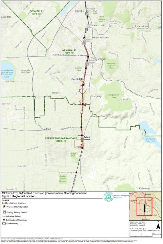
Figure 1 Regional Location ........................................................................................................... 28
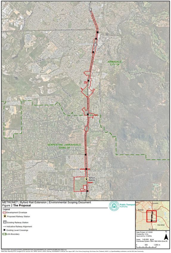
Figure 2 The Proposal .................................................................................................................. 29
3Environmental Scoping Document
Proposal name: Byford Rail Extension
Proponent: Public Transport Authority of Western Australia
Assessment number: 2261
Location: 26 km south-east of Perth, 8 km south of Armadale
Local Government Area: City of Armadale, Shire of Serpentine-Jarrahdale
EPBC reference no: 2020/8764
Public Transport Authority 41. Introduction
The Public Transport Authority of Western Australia (PTA) is proposing to develop and implement
the Byford Rail Extension Proposal (the Proposal). The Proposal is one of several METRONET
projects that aim to improve and integrate the public transport network and align with the State
Government’s vision for future land use planning in Western Australia. The Proposal comprises 8 km
of rail connecting Armadale, approximately 26 km south-east of Perth to Byford located 8 km south
of Armadale. The Proposal will extend the existing electrified passenger rail network from Armadale
Station to the proposed new Byford Station. The northern section of the Proposal is within the City
of Armadale. The southern section is within the Shire of Serpentine - Jarrahdale.
The Environmental Protection Authority (EPA) has determined that the Proposal is to be assessed
under Part IV of the Environmental Protection Act 1986 (EP Act). The decision to assess the
Proposal was made on 7 October 2020 and the level of assessment was set at Public Environmental
Review.
The EPA determined that the proponent should prepare the Environmental Scoping Document
(ESD). The purpose of the ESD is to define the form, content, timing and procedure of the
environmental review, required by s. 40(3) of the EP Act. This ESD has been prepared by the PTA
in consultation with the EPA, decision-making authorities and interested agencies consistent with
the EPA’s Environmental Impact Assessment (Part IV Divisions 1 and 2) Procedures Manual (EPA
2020a).
Form
The EPA requires that the form of the report on the environmental review required under s. 40
(Environmental Review Document (ERD)) is according to the Environmental Review Document
template (refer to the EPA’s Instructions on how to prepare an Environmental Review Document,
EPA, 2020b). Additional information can also be included where relevant to the EPA’s assessment.
Content
The EPA requires that the environmental review includes the content outlined in Sections 2 to 6 of
this ESD.
5Timing
Table 1 sets out the indicative timeline for the assessment of the Proposal agreed between the EPA
and the proponent. This indicative timeline is subject to the provision of adequate information.
Table 1: Indicative Assessment Timeline
Completion
Key Assessment Milestones
Date
EPA approves Environmental Scoping Document 24 Dec 2020
Proponent submits first draft Environmental Review Document 2 Mar 2021
EPA provides comment on first draft Environmental Review Document
15 Mar 2021
Proponent submits revised draft Environmental Review Document
29 Mar 2021
EPA authorises release of Environmental Review Document for public review
6 Apr 2021
Proponent releases Environmental Review Document for public review for 2 weeks
12 Apr 2021
Close of public review period
27 Apr 2021
EPA provides Summary of Submissions
3 May 2021
Proponent provides Response to Submissions
18 May 2021
EPA reviews the Response to Submissions
1 Jun 2021
EPA considers draft assessment report at EPA Board meeting and completes
15 Jul 2021
assessment
Following EPA Board meeting EPA finalises assessment report following EPA Board
28 Jul 2021
meeting (including two weeks consultation on draft conditions) and gives report to
Minister
Procedure
The EPA requires the proponent to undertake the environmental review according to the procedures
in the Administrative Procedures and the Procedures Manual (EPA 2020a).
This ESD has not been released for public review. The ESD will be available on the EPA website
(www.epa.wa.gov.au) upon endorsement and must be appended to the ERD.
Assessment as an accredited assessment (EPBC 2020/8764)
The Proposal is being assessed under a State level Public Environmental Review process with two
weeks of public review, which provides for prevention, minimisation and management of any relevant
impacts. The Proposal is also subject to local or State government planning schemes and policies
as described in Section 6.
Public Transport Authority 6The Proposal has been referred to the Commonwealth Department of Agriculture, Water and the
Environment (DAWE) under the Environment Protection and Biodiversity Conservation Act 1999
(EPBC Act) (EPBC 2020/8764). The DAWE determined on 12 October 2020 that the Proposal is a
controlled action under the EPBC Act. The Proposal is being assessed as an accredited assessment
by the EPA.
The relevant matters of national environmental significance (MNES) for the Proposal are:
Listed threatened species and communities (sections 18 and 18A).
This ESD includes work required to be carried out and reported on in the ERD in relation to MNES.
The ERD will also address the matters in Schedule 4 of the Environment Protection and Biodiversity
Conservation Regulations 2000.
MNES that may be impacted by the Proposal will be identified and the potential impacts on these
matters addressed within each relevant preliminary environmental factor identified in Table 4. The
ERD will include a separate section that summarises the potential impacts on MNES and describes,
to the extent practicable, any feasible alternatives to the proposed action and possible mitigation
measures. Proposed offsets to address significant residual impacts on MNES will also be discussed.
72. The Proposal
The Proposal is part of the Western Australian Government’s vision to implement and build
METRONET, which will aid in transforming Perth’s public transport network (METRONET 2019). The
long-term vision (i.e. to 2050) is for a public transport network to support a population of 3.5 million
people.
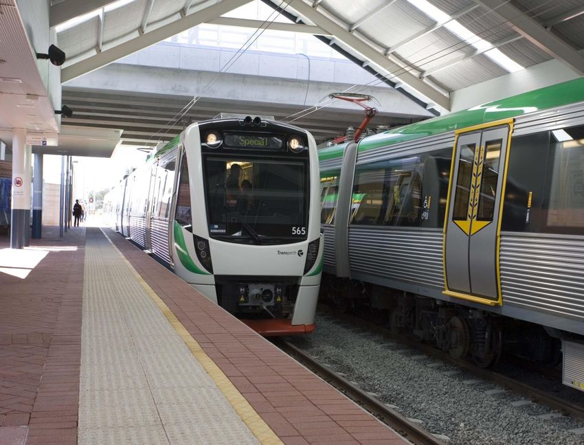
The PTA aims to implement the Proposal by constructing and operating an extension to the
electrified passenger railway line between Armadale and Byford. The existing Armadale Station will
be modified and a new Byford station will be constructed.
The Proposal includes an electrified 8 km dual track railway that will connect Armadale Station to
the new Byford Station. The Proposal also includes replacement of a number of existing at-grade
rail crossings (level crossings) with grade separated crossings, either road over rail or rail over road.
The Development Envelope includes the area to be occupied by permanent infrastructure as well as
temporary construction and access areas required to construct the Proposal.
A new Byford Station (north of Abernethy Road), with intermodal rail, bus, carpark, and active mode
(cycling and walking) facilities, will be constructed and operated.
The Proposal will be constructed within the existing non-electrified Australind rail corridor from
Armadale to Byford. Modifications will also be required within a portion of the existing electrified rail
corridor between Sherwood Station and Armadale Station.
The ERD is to include a section that sets out how the PTA evaluated, compared and considered
alternative route alignments and construction methods during the planning phase of the Proposal to
avoid and minimise the extent of potential environmental impacts, particularly on biodiversity values.
A summary and the key characteristics of the Proposal are set out in Tables 2 and 3. The key
proposal characteristics may change as a result of the findings of studies and investigations
conducted and the application of the mitigation hierarchy by the Proponent.
Table 2: Summary of the Proposal
Item Details
Proposal title Byford Rail Extension
Proponent name Public Transport Authority of Western Australia
Short description
The Proposal is to construct and operate an 8 km new railway (including dual
tracks and associated rail infrastructure) between Armadale and Byford. The
Proposal includes modification to the existing Armadale Station and construction
of a new Byford Station. The Proposal also includes the replacement of a number
of existing at-grade line crossings (level crossings) with grade separated
crossings, either road over rail or rail over road.
Public Transport Authority 8Table 3: Location and proposed extent of physical and operational elements
Element Location Proposed extent
Physical elements
The new 8 km dual railway track Disturbance of up to 160 ha of the
Railway tracks and
extends the existing electrified rail Development Envelope, including
associated
network at Armadale in a southerly clearing of up to 50 ha of vegetation.
infrastructure
direction using the existing Australind The project footprint will be developed
rail corridor (the Corridor) to the new during the project design phase and
Byford Station, north of Abernethy will minimise environmental impacts
Road, Byford (Figure 1). Rail including the clearing of native
modifications will also be required as vegetation where practicable.
far as Sherwood Station 1.5 km north
of Armadale Station.
Located approximately 500 m south of Modifications to the existing railway
Armadale Station
Armadale Road, Armadale (Figure 1). station and associated facilities
(modifications)
including intermodal rail, bus, ‘park and
ride’, ‘kiss and ride’ and active mode
(walking/cycling) facilities.
Located approximately 8 km south of New railway station and associated
Byford Station
the existing Armadale Station, 400 m facilities including intermodal rail, bus,
north of Abernethy Road, Byford (Figure ‘park and ride’, ‘kiss and ride’ and active
1). mode (walking/cycling) facilities.
Located along the Corridor. Existing level crossings will be retained,
Level Crossings
closed or replaced with grade separated
crossings, depending on the most
appropriate design option. Each
crossing will fit entirely within the
Development Envelope.
Rail crossing over Wungong Brook. Duplication of rail bridge over Wungong
Wungong Brook
Brook.
Rail Bridge
Where practicable the PTA will locate Construction and access areas in and
Construction and
temporary construction areas in areas adjacent to the Corridor, entirely within
access areas
of existing disturbance. the 160 ha Development Envelope.
Operational elements
The passenger railway will operate as The passenger railway will operate
Rail and Bus
an extension to the existing Perth to within the 160 ha Development
Services
Armadale line, extending 8 km to Byford Envelope (Figure 2).
(Figure 1). New rail and bus services
are proposed for Byford Station.
93. Preliminary Key Environmental Factors and
required work
The preliminary key environmental factors for the environmental review are:
Flora and vegetation.
Terrestrial fauna.
Inland waters.
Social surroundings.
Table 4 outlines the work required for each preliminary key environmental factor and contains the
following elements for each factor:
EPA factor and EPA objective for that factor.
Relevant activities – the Proposal activities that may have a significant impact on that factor.
Potential impacts and risks to that factor.
Required work for that factor.
Relevant policy and guidance – EPA (and other) guidance and policy relevant to the assessment.
The following EPA guidance applies to all factors:
Statement of Environmental Principles, Factors and Objectives (EPA 2018b).
Instructions and Template: Part IV Environmental Management Plans (EPA 2020c)
Instructions on how to prepare an environmental review document (EPA 2020b)
The following guidance applies to Flora and Vegetation and Fauna factors:
Instructions for the preparation of data packages for the Index of Biodiversity Surveys for
Assessments (IBSA) (EPA 2020c).
Public Transport Authority 10Table 4: Preliminary Key Environmental Factors and required work
3.1. Flora and Vegetation
EPA Objective To protect flora and vegetation so that biological diversity and ecological integrity
are maintained.
Clearing of native vegetation.
Relevant activities
Cut and fill works.
Construction of permanent and temporary infrastructure including but not
limited to rail, roads, car parks, buildings, hard stand and laydown areas.
Operation of plant, machinery and service vehicles.
Operation and maintenance of the electrified railway line.
Soil compaction.
Temporary dewatering and groundwater abstraction for construction
purposes, if required.
Permanent loss of flora and vegetation through clearing.
Potential impacts
and risks Indirect impacts from dust, weeds, change to surface water drainage flow
patterns and infiltration during rainfall events and/or edge effects.
Impacts from the introduction and/or distribution of diseases to
surrounding bushland areas, including Phytophthora Dieback.
Fragmentation of intact native vegetation including impacts on significant
ecological communities, and the potential for fragmentation of ecological
linkages.
Potential indirect impacts on significant ecological communities and
groundwater dependant ecosystems from dewatering and groundwater
abstraction, if required.
Clearing of significant flora that occur, or have a high likelihood or
occurring, within the Development Envelope
Increased risk of bushfire from operation of an electrified railway near
areas of vegetation.
Required Work 1. Identify and characterise the flora and vegetation that may be directly or
indirectly impacted by the Proposal, in accordance with Technical Guidance
- Flora and Vegetation Surveys for Environmental Impact Assessment (EPA
2016b). Surveys should be designed to inform local and regional context.
Surveys should also utilise the DAWE Protected Matters Search Tool, where
appropriate.
2. Demonstrate how surveys are relevant, representative and demonstrate
consistency with current EPA policy and guidance. Ensure database
searches and taxonomic identifications are up-to-date. All surveys should be
appended to the ERD.
Note: Survey results and a demonstration of how the requirements have been
met are to be included in the ERD. Where surveys were undertaken prior to
scoping, justification should be provided to demonstrate that they are relevant
and consistent with EPA Guidance. Where surveys have not been undertaken
consistent with the EPA Guidance provide a justification for any variation. If
multiple surveys have been undertaken to support the assessment, a
consolidated report should be provided including the integrated results of the
surveys.
3. Provide a figure depicting survey effort applied in relation to the survey area
and Development Envelope, identifying the direct and indirect impact areas.
4. Determine whether any flora species recorded are significant and provide an
analysis of local and regional context (refer to Environmental Factor
Guideline – Flora and Vegetation for definition of significant flora).
115. Determine whether any vegetation identified is significant and provide an
analysis of local and regional context.
6. Provide figures depicting the recorded locations of flora and vegetation in
relation to the Development Envelope in accordance with Technical
Guidance – Flora and Vegetation Surveys for Environmental Impact
Assessment (EPA 2016b).
7. Assess the potential direct and indirect impacts of the construction and
operational elements of the Proposal on identified environmental values.
Describe and assess the extent of cumulative impacts as appropriate.
8. Provide a quantitative assessment of impact:
o For significant flora, this includes:
number of individuals and populations in a local and regional
context based on survey data and existing database records,
where available
numbers and proportions of individuals and populations
directly or potentially indirectly impacted, and
numbers/proportions/populations currently protected
within the conservation estate (where known).
Note: Every effort should be made to obtain information on the number of
individuals and populations of significant flora in a local and regional context.
This may include multiple surveys and will require surveys to be undertaken
at an appropriate time for each significant flora species that may be present.
o For all vegetation units (noting threatened and priority ecological
communities and significant vegetation) this includes:
area (in hectares) and proportions directly or potentially
indirectly impacted, and
proportions/hectares of the vegetation unit currently
protected within the conservation estate (where known).
Note: Each survey report should be accompanied by an IBSA number,
generated following acceptance of an IBSA data package via the IBSA
submissions portal at https://ibsasubmissions.dwer.wa.gov.au/
9. Describe the application of the mitigation hierarchy in the proposal design,
construction and operation. Detail actions to be undertaken to avoid, minimise
and mitigate impacts from the Proposal including revegetation of areas not
required for permanent infrastructure.
10. Provide management and /or monitoring plans to be implemented pre- and
post-construction to demonstrate that residual impacts are not greater than
predicted. Management and / or monitoring plans are to be prepared in
accordance with EPA instructions and consistent with the Australian
Government Environmental Management Plan Guidelines (DofE 2014).
Management Plans need to consider all relevant EPBC Act listed threatened
flora species and threatened ecological communities where appropriate.
11. Demonstrate how the Proposal has had regard to, and is not inconsistent
with, relevant recovery plans, conservation advice and threat abatement
plans.
12. Describe how the Proposal has considered the Australian Government
Significant Impact Guidelines 1.1 (DEWHA 2013) for all direct and indirect
impacts on matters protected under the EPBC Act.
13. Demonstrate how the EPA’s objective for this factor has been addressed.
14. Determine and quantify any significant residual impacts by applying the:
o residual Impact Significance Model (page 11 of the WA
Environmental Offsets Guideline) for all direct and indirect impacts,
including an explanation of how the information and values within
the model have been determined,
Public Transport Authority 12o WA Offset Template in the WA Environmental Offsets Guidelines
(2014), including the provision of supporting information, and
o the Australian Government Offsets Assessment Guide
(DSEWPAC 2012a) including rationale for the values entered into
the guide.
15. Assessment of whether the proposed offset is likely to counter-balance any
significant residual impact, and whether the EPA’s environmental factor
objective will be met, over all relevant timeframes. Where significant residual
impacts remain, propose an appropriate offsets package that is consistent with
the WA Environmental Offsets Policy and Guidelines (GoWA 2014). Spatial
data defining the area of significant residual impacts for each environmental
value should also be provided (e.g. vegetation type, vegetation condition,
specific flora species habitat).
16. Assessment of whether the proposed offset is likely to counter-balance any
significant residual impact, and whether the EPA’s environmental factor
objective will be met, over all relevant timeframes. Where significant residual
impacts remain to any EPBC Act listed threatened species or threatened
ecological community, propose an appropriate offset package consistent with
the Commonwealth Environmental Offsets Assessment Guide (DSEWPAC
2012a) and the EPBC Act Environmental Offsets Policy (DSEWPAC 2012b).
Demonstrate how the proposed offset is consistent with each of the principles
of the Commonwealth Environmental Offsets Policy in addition to providing a
rationale for the values entered into the offset guide. Spatial data defining the
area of significant residual impacts for each environmental value should also
be provided (e.g. vegetation type, vegetation condition, specific flora species
habitat)
Policy and guidance EPA Policy and Guidance
Environmental Factor Guideline – Flora and Vegetation (EPA, 2016)
Technical Guidance – Flora and Vegetation Surveys for Environmental
Impact Assessment (EPA, 2016)
Guidance Statement 6 – Rehabilitation of Terrestrial Ecosystems (EPA,
2006).
Environmental Protection Bulletin 20 – Protection of naturally vegetated
areas through planning and development (EPA, 2013).
Other policy and guidance
Significant Impact Guidelines 1.1 - Matters of National Environmental
Significance, Commonwealth of Australia (DEWHA 2013).
Department of the Environment and Energy (2018). Threat abatement plan for
disease in natural ecosystems caused by Phytophthora cinnamomi.
Canberra: Commonwealth of Australia.
Corymbia calophylla - Kingia australis woodlands on heavy soil (Swan
Coastal Plain Community type 3a - Gibson et al. 1994) interim recovery
plan 2011-2016
Environmental Management Plan Guidelines (DotE 2014).
State Planning Policy No. 2.8 Bushland Policy for the Perth Metropolitan
Region (WAPC, 2010).
Western Australian Environmental Offsets Policy (GoWA, 2011).
Western Australian Environmental Offsets Guidelines (GoWA, 2014).
Western Australian Environmental Offsets Template (GoWA, 2014).
Relevant recovery plans, conservation advice and/or threat abatement
plans for conservation significant species and EPBC Act listed threatened
species and ecological communities that are known to occur, or are likely
to occur in the vicinity of the Proposal’s Development Envelope.
13 Survey guidelines for Australia’s threatened orchids: Guidelines for
detecting orchids listed as ‘Threatened’ under the Environment Protection
and Biodiversity Conservation Act 1999 (DEWHA 2013).
Environment Protection and Biodiversity Conservation Act 1999,
Environmental Offsets Policy (DSEWPC 2012).
How to use the Offsets assessment guide. Department of Sustainability,
Environment, Water, Population and Communities (DSEWPC 2012).
Department of the Environment and Energy (2017). Approved
Conservation Advice for Corymbia calophylla - Kingia australis
woodlands on heavy soils of the Swan Coastal Plain. Canberra:
Department of the Environment and Energy.
English, V. & J. Blyth (2000). Corymbia calophylla - Kingia australis
woodlands on heavy soil (Swan Coastal Plain Community type 3a -
Gibson et al. 1994), Interim Recovery Plan 2000-2003. Interim Recovery
Plan No. 59. Department of Conservation and Land Management,
Wanneroo, Western Australia.
Department of the Environment and Energy (2017). Approved
Conservation Advice for Corymbia calophylla - Xanthorrhoea preissii
woodlands and shrublands of the Swan Coastal Plain. Canberra:
Department of the Environment and Energy.
English, V. & J. Blyth (2000). Corymbia calophylla - Xanthorrhoea preissii
woodlands and shrublands (Swan Coastal Plain Community type 3c -
Gibson et al. 1994), Interim Recovery Plan 2000-2003. Interim Recovery
Plan No. 60. Department of Conservation and Land Management,
Wanneroo, Western Australia.
Department of Sustainability, Environment, Water, Population and
Communities (2012). Approved Conservation Advice for Clay Pans of the
Swan Coastal Plain. Canberra, ACT: Department of Sustainability,
Environment, Water, Population and Communities.
Threatened Species Scientific Committee (TSSC) (2012).
Commonwealth Listing Advice on Claypans of the Swan Coastal Plain.
Department of Sustainability, Environment, Water, Population and
Communities. Canberra, ACT: Department of Sustainability,
Environment, Water, Population and Communities.
Department of Biodiversity, Conservation and Attractions (2019).
National Recovery Plan for the Clay pans of the Swan Coastal Plain
Ecological Community. Department of Biodiversity, Conservation and
Attractions, Perth, Western Australia.
Threatened Species Scientific Committee (2016). Approved
Conservation Advice (incorporating listing advice) for the Banksia
Woodlands of the Swan Coastal Plain ecological community. Canberra:
Department of the Environment and Energy.
Department of the Environment, Water, Heritage and the Arts (2008).
Approved Conservation Advice for Diuris purdiei (Purdie's Donkey-
orchid). Canberra: Department of the Environment, Water, Heritage and
the Arts.
Department of the Environment, Water, Heritage and the Arts (2008).
Approved Conservation Advice for Drakaea micrantha (Dwarf Hammer-
orchid). Canberra: Department of the Environment, Water, Heritage and
the Arts.
Department of Environment and Conservation (2004). Eucalyptus
balanites Interim Recovery Plan 2004-2009. Interim Recovery Plan no.
182. Department of Environment and Conservation, Western Australia.
Threatened Species Scientific Committee (2018). Conservation Advice
Synaphea sp. Pinjarra Plain (A.S. George 17182). Canberra: Department
of the Environment and Energy.
Threatened Species Scientific Committee (2018). Conservation Advice
Synaphea sp. Serpentine (G.R. Brand 103). Canberra: Department of the
Environment and Energy.
Public Transport Authority 14 Department of the Environment, Water, Heritage and the Arts (2008).
Approved Conservation Advice for Tetraria australiensis (Southern
Tetraria). Canberra: Department of the Environment, Water, Heritage
and the Arts.
Advice on the presence of hybrids in listed ecological communities
(Threatened Species Scientific Committee (TSSC), 2011)
3.2. Terrestrial Fauna
EPA Objective To protect terrestrial fauna so that biological diversity and ecological integrity are
maintained.
Relevant activities Permanent clearing of native vegetation.
Cut and fill works.
Construction of permanent and temporary infrastructure including rail, roads,
buildings, hard stand, fencing and laydown areas.
Lighting (and noise) during construction and operation.
Movement of machinery and vehicles.
Operation and maintenance of the electrified railway line.
Potential impacts Permanent loss of fauna habitat due to clearing and construction of
and risks infrastructure.
Fauna deaths and injury resulting from collisions with earth moving equipment
and/or vehicles during construction and operation.
Fragmentation of fauna habitat, barriers to fauna movement and/or loss of
ecological connectivity.
Degradation of habitat and habitat modification from introduction and
increased spread of weeds and/or disease, soil pathogens, altered surface
water flows and edge effects.
Noise and lighting during construction and operation may impact or change
fauna movement and behaviour.
Change in feral animal abundance and/or movement.
Required Work 17. In accordance with the requirements of EPA Guidance conduct a desktop
study to identify and characterise the terrestrial fauna and fauna habitats to
inform local and regional context. Surveys should also utilise the Department
of Agriculture Water and the Environment (DAWE) Protected Matters Search
Tool, where appropriate.
18. Based on the results of the desktop study:
o conduct a Basic (Level 1) survey and fauna habitat assessment,
o conduct a Detailed (Level 2) survey, and
o conduct targeted surveys for significant fauna that may be
directly or indirectly impacted including for the three species of
Black Cockatoos; Carnaby’s cockatoo, Baudin’s cockatoo, forest
red-tailed cockatoo, and Carter's Freshwater Mussel -
Westralunio carteri.
Note: The desktop study, surveys and ERD should consider vertebrate fauna
(including aquatic fauna) and Short Range Endemic (SRE) and/or other
significant invertebrates. Survey design should ensure that adequate local and
regional contextual data are collected and should consider cumulative impacts.
Surveys should include sites in both impact and non-impact (reference) areas.
19. Demonstrate how surveys are relevant, representative and consistent with
current EPA policy and guidance and this scoping document.
1520. Provide a map of the survey effort applied in relation to the fauna habitats, the
survey area, Development Envelope, identifying the direct and indirect impact
areas.
21. Identify and describe the fauna assemblages present and likely to be present
within the Development Envelope that may be impacted by the Proposal.
22. Identify and describe the characteristics of the fauna habitats identified by the
desktop study and surveys, including a map of their extents in relation to the
study area, the Development Envelope and direct and indirect impact areas.
Describe significant habitats, including but not limited to: refugia, breeding
areas, key foraging habitat, movement corridors and linkages
23. Identify significant fauna and describe in detail their known ecology, likelihood
of occurrence, habitats and known threats. Map the locations of significant
fauna records in relation to the fauna habitats, the study area, the
Development Envelope, and direct and indirect impact areas.
Note: Survey reports should be prepared following EPA Guidance and appended
to the ERD. Ensure species database searches and taxonomic identifications
are up-to-date. IBSA data packages should be submitted in accordance with
EPA guidance and an IBSA number should be submitted with each survey
report. If multiple surveys have been undertaken to support the assessment, a
consolidated report should be provided including the integrated results of the
surveys. Reports for vertebrate fauna and SRE (and/or other significant)
invertebrate fauna should be provided separately.
24. Identify any potential fauna movement corridors within, adjacent to or across
the Development Envelope including, but not limited to, areas of intact native
vegetation, using appropriate methods. Describe the methods taken.
25. Identify, describe and quantify the potential impacts (direct, indirect and
cumulative) on fauna assemblages, habitats and significant species that may
occur following implementation of the Proposal in a local and regional context.
26. In accordance with relevant guidelines set out below, provide figures and
maps illustrating fauna habitats, known recorded locations of significant
vertebrate species and SRE (and/or other significant) invertebrate fauna in
relation to the Development Envelope.
27. Demonstrate that no SRE invertebrate fauna is restricted to the Development
Envelope or that such species have been adequately surveyed outside of the
Development Envelope.
28. Provide a table of the extents of each habitat within the Development
Envelope and survey extent, and the predicted amount to be directly and
indirectly impacted. Consider potential impacts on all State and
Commonwealth listed threatened fauna species that are known or likely to occur
within and/or adjacent to the Development Envelope.
29. Outline and justify the proposed avoidance and mitigation measures to reduce
the potential impacts of the Proposal.
30. Provide management and /or monitoring plans to be implemented pre- and
post-construction to demonstrate that residual impacts are not greater than
predicted. Management and / or monitoring plans are to be prepared in
accordance with EPA instructions and consistent with the Australian
Government Environmental Management Plan Guidelines (DofE 2014).
Management and/or monitoring plans are to be presented in accordance with
the EPAs Instructions.
31. Demonstrate how the Proposal has had regard to, and is not inconsistent with
any relevant recovery plans, conservation advice and threat abatement plans.
32. Predict the residual impacts on terrestrial fauna after considering and applying
the mitigation hierarchy.
33. Determine and quantify any significant residual impacts by applying the:
o residual Impact Significance Model (page 11 of the WA
Environmental Offsets Guideline) for all direct and indirect impacts,
including an explanation of how the information and values within
Public Transport Authority 16the model have been determined,
o WA Offset Template in the WA Environmental Offsets Guidelines
(2014), including the provision of supporting information, and
o the Australian Government Offsets Assessment Guide (DSEWPAC
2012a) including rationale for the values entered into the guide.
34. Assessment of whether the proposed offset is likely to counter-balance any
significant residual impact, and whether the EPA’s environmental factor
objective will be met, over all relevant timeframes. Where significant residual
impacts remain, propose an appropriate offsets package with supporting
information to demonstrate consistency with the WA Environmental Offsets
Policy and Guidelines. Where residual impacts relate to EPBC Act listed
threatened species propose an appropriate offset package consistent with
the Commonwealth and WA Environmental Offsets Policy. Spatial data
defining the area of significant residual impacts for each environmental value
should also be provided (e.g. specific fauna species habitat).
35. Assessment of whether the proposed offset is likely to counter-balance any
significant residual impact, and whether the EPA’s environmental factor
objective will be met, over all relevant timeframes. Propose an appropriate
offset package consistent with the Commonwealth Environmental Offsets
Policy for the predicted likely significant residual impact to Black Cockatoos.
Demonstrate how the proposed offset is consistent with each of the principles
of the Commonwealth Environmental Offsets Policy in addition to providing a
rationale for the values entered into the offset guide. Spatial data defining the
area of significant residual impacts for each environmental value should also
be provided (e.g. vegetation type, vegetation condition, specific fauna
species habitat).
EPA Policy and Guidance
Policy and guidance
Environmental Factor Guideline – Terrestrial Fauna (EPA 2016c)
Technical Guidance - Terrestrial vertebrate fauna surveys for
environmental impact assessment (EPA 2016e)
Technical Guidance: Sampling of short range endemic invertebrate
fauna (EPA 2016f)
EPA Advice: Carnaby's cockatoo in environmental impact assessment in
the Perth and Peel region (EPA 2019)
Other policy and guidance
Baudin’s cockatoo Calyptorhynchus baudinii and Forest red-tailed black
cockatoo Calyptorhynchus banksii naso) Recovery Plan (DEC, 2008).
Carnaby's cockatoo (Calyptorhynchus latirostris) Recovery Plan (DPAW,
2013).
Chuditch (Dasyurus geoffroii) Recovery Plan (DEC, 2012).
Western Australian Environmental Offsets Policy (GoWA, 2011).
Western Australian Environmental Offsets Guidelines (GoWA, 2014).
Western Australian Environmental Offsets Template (GoWA, 2014).
Relevant recovery plans, conservation advice and/or threat abatement
plans for conservation significant species and EPBC Act listed threatened
species that are known to occur, or are likely to occur, in the vicinity of the
Development Envelope.
Draft Revised Referral Guideline for Three Threatened Black Cockatoo
Species: Carnaby’s cockatoo, Baudin’s cockatoo, Forest red-tailed black
cockatoo (DotEE, 2017)
Referral guidelines for three species of Western Australian black
cockatoos (Department of Sustainability, Environment, Water, Population
and Communities (DSEWPaC), 2012
Environmental Offsets Policy (DSEWPC 2012).
Survey guidelines for Australia's threatened birds: Guidelines for
detecting birds listed as threatened under the EPBC Act (DEWHA, 2010).
17 Department of the Environment and Energy (2018). Threat abatement
plan for disease in natural ecosystems caused by Phytophthora
cinnamomi. Canberra: Commonwealth of Australia.
Threat Abatement Plan for Predation by Feral Cats, (DotE, 2015).
Threat Abatement Plan for Predation by the European Red Fox,
(DEWHA, 2008).
Threat Abatement Plan for Competition and Land Degradation by
Rabbits, (DotE, 2016).
Environmental Management Plan Guidelines (DotE, 2014).
Threatened Species Scientific Committee Conservation Advice
Westralunio carteri Carter's freshwater mussel. (DoEE, 2018).
Threatened Species Scientific Committee (2018). Conservation Advice
Calyptorhynchus baudinii Baudin's cockatoo. Canberra: Department of
the Environment and Energy.
Department of the Environment, Water, Heritage and the Arts (2009).
Approved Conservation Advice for Calyptorhynchus banksii naso (Forest
Red-tailed Black Cockatoo). Canberra: Department of the Environment,
Water, Heritage and the Arts.
3.3. Inland Waters
EPA Objective To maintain the hydrological regimes and quality of groundwater and surface
water so that environmental values are protected
Clearing of native vegetation.
Relevant activities
Dewatering and/or abstraction of groundwater.
Construction of railway and hard stand areas.
Decommissioning and removal of Wungong Brook rail bridge.
Construction of new bridge over Wungong Brook.
Alteration of landscape for construction of railway, associated
infrastructure and laydown areas.
Storage and use of chemicals and fuels.
Refuelling and servicing of vehicles and machinery.
Temporary dewatering and groundwater abstraction for construction
purposes, if required.
Ongoing presence of railway, stations and associated infrastructure.
Interruption of and changes to surface water flows to Wungong Brook
Potential impacts
and Conservation Category Wetlands.
and risks
Changes to infiltration and recharge of groundwater.
Changes to surface water quality due to contamination from spills,
discharge of dewatering effluent.
Changes in groundwater quality and quantity due to dewatering and/or
groundwater abstraction.
Indirect impacts on groundwater dependent ecosystems and/or riparian
vegetation due to changes to surface water flows or hydrogeological
regimes.
Degradation of Conservation Category Wetlands (CCW’s) and Resource
Enhancement Wetlands (REW’s) that intersect or are adjacent to the
Development Envelope.
Increase in sediment loads entering waterways and/or wetlands.
Changes in surface water or groundwater quality associated with the
disposal of dewatered effluent.
Loss of terrestrial (freshwater) fauna due to changes in water quality or
hydrological regimes.
Public Transport Authority 18Required Work 36. Characterise the local and regional hydrogeological regime and describe
recharge and discharge mechanisms and surface water/groundwater
interaction.
37. Identify, describe and assess the environmental values and significance of
surface and groundwater hydrological characteristics within the Development
Envelope and the immediately adjacent area upstream and downstream of
the Development Envelope. Describe these values in local and regional
contexts. Identify users of the identified values.
38. Identify, describe and assess the wetlands within and in proximity to the
Development Envelope. Describe these values in local and regional contexts.
Wetland assessments should be undertaken in accordance with ‘A
methodology for the evaluation of wetlands on the Swan Coastal Plain’
(DBCA 2017). This document, in addition to information regarding wetland
delineation and identification, can be obtained at
https://www.dpaw.wa.gov.au/management/wetlands/publications-and-links.
Wetland identification and assessment should utilise the Department of
Biodiversity Conservation and Attractions (DBCA) Geomorphic Wetlands
Swan Coastal Plain Dataset or any approved update or replacement of this
dataset.
39. Identify, describe, analyse and assess the potential impacts (direct and
indirect) as a result of both construction and operation of the proposal on
water quantity (excess and deficit) and quality in relation to surface and
groundwater, waterways and their floodplains and wetlands within and near
the development envelope.
40. Predict the extent, severity and duration of potential impacts to the
environmental values identified, including from changes to local and regional
surface and groundwater flows and levels (excess and deficit), groundwater
drawdown, local surface and groundwater quality and impacts to surface and
groundwater users as a result of construction and operation.
41. Identify, describe and assess the potential impacts on Wungong Brook flood
levels and upstream and downstream flood levels from the associated
bridge/crossing.
42. Identify the preferred location of groundwater abstraction zones for water
required to implement the proposal.
43. Demonstrate how the mitigation hierarchy of avoid, minimise, mitigate has
been applied during the planning and design stages of the Project.
44. Describe and justify any proposed mitigation to reduce the potential impacts
of construction and operation of the Proposal on the identified values. I
45. Provide management and /or monitoring plans to be implemented pre- and
post-construction to demonstrate that residual impacts are not greater than
predicted. Management and / or monitoring plans are to be prepared in
accordance with the EPA’s instructions to demonstrate and ensure the EPA’s
objective can be met. Plans to include any hydrological and hydrogeological
assessments undertaken for dewatering and abstraction.
46. Provide maps of and justification for the location and number of any proposed
drainage and stormwater infrastructure.
47. Discuss the proposed management, monitoring and mitigation to ensure
impacts on inland water ecological values are not greater than predicted as
a result of implementing the Proposal. This is to include, but not be limited to,
consideration of suitable buffers, between the boundary of the Development
Envelope and waterways and wetlands.
48. Demonstrate how best practice Water Sensitive Urban Design principles will
be implemented in the design of the infrastructure and in stormwater and
drainage components to ensure hydrological regimes and groundwater
quality are maintained.
49. Assessment of whether the proposed offset is likely to counter-balance any
significant residual impact, and whether the EPA’s environmental factor
objective will be met, over all relevant timeframes. Identify, describe and
19quantify the potential residual impacts (direct and indirect) that may occur
following implementation of the proposed mitigation measures and determine
the significance of the residual impacts on the identified environmental values
by applying the residual impact significance model (page 11) and WA Offset
template (Appendix 1) in the WA Environmental Offsets Guidelines (2014).
Provide spatial data defining the area of any identified significant residual
impacts and proposed offsets in relation to the Development Envelope.
Where significant residual impacts remain, propose an appropriate offsets
package that is consistent with the WA Environmental Offsets Policy.
Note: Offsets may be appropriate if the construction or operation of the proposal
results in a change in the hydrology of a wetland upstream or downstream of the
development envelope such that the wetland or its ecological function are
significantly impacted by the proposal. In this instance an offset would be
appropriate to counter the significant residual impact to the hydrological
processes of the wetland. Refer to Figure 3 of the WA Environmental Offsets
Guidelines, 2014.
EPA Policy and Guidance
Policy and guidance
Environmental Factor Guideline: Inland Waters (EPA 2018).
Other Policy and Guidance
State Planning Policy 2.9 Water Resources (WAPC, 2006).
Environmental Water Provisions Policy for Western Australia (Water and
Rivers Commission, 2000).
Wetlands Conservation Policy for Western Australia (Government of
Western Australia, 1997).
A Guide to Managing and Restoring Wetlands in Western Australia (DEC
2012).
Geomorphic Wetlands Swan Coastal Plain Dataset (DBCA, 2020) or any
approved update of this dataset.
Water Quality Protection Note 10, Contaminant Spills Emergency
Response (DoW, 2006).
Water Quality Protection Note 56: Tanks for Fuel and Chemical Storage
Near Sensitive Water Resources (DWER, 2018).
Water Quality Protection Note 83, Infrastructure Corridors Near Sensitive
Water Resources (DoW, 2007).
Western Australian Environmental Offsets Policy (GoWA, 2011).
Western Australian Environmental Offsets Guidelines (GoWA, 2014).
Western Australian Environmental Offsets Template (GoWA, 2014).
3.4. Social Surroundings
EPA Objective To protect social surroundings from significant harm.
Cut and fill works including temporary impacts associated with excavation
Relevant activities
activities, soil movement and stockpiling.
Clearing of native vegetation.
Soil compaction.
Construction activities associated with building the railway including rail
infrastructure, stations, roads, buildings and other hard stand areas.
Operation of plant, machinery and service vehicles.
Operation and maintenance of the electrified railway line.
Installation of railway and associated infrastructure.
Public Transport Authority 20 Impacts on Registered Aboriginal Heritage Sites or cultural heritage
Potential impacts
values.
and risks
Temporary exposure to construction noise and vibration for sensitive
receptors near the Development Envelope.
Increased noise from vehicle movements during construction impacting
the amenity of landowners.
Increased and ongoing exposure to operational noise and vibration for
sensitive receptors in close proximity to the rail infrastructure.
Changes to visual amenity within the landscape due to the construction
of the railway and associated vegetation clearing, road and/or rail bridges
and noise walls or barriers in a rural setting.
Required Work 50. Characterise, describe and analyse the surrounding land use and amenity
values in and adjacent to the Development Envelope with a focus on sensitive
receptors that may be impacted by noise and vibration or impacts to visual
amenity. Include relevant maps to identify the sensitive receptors likely to be
affected by these impacts associated with the Proposal.
51. Demonstrate how the mitigation hierarchy of avoid, minimise and mitigate has
been applied during the planning and design stages of the project to minimise
potential impacts on social surroundings.
Aboriginal Heritage
52. Conduct ethnographic and archaeological surveys of the area likely to be
impacted by the Proposal in order to identify and characterise any Aboriginal
heritage sites and their relevance and importance to Aboriginal People and
their culture. Include details of the discussions and considerations of the
indirect impacts to registered Aboriginal heritage sites.
53. Provide a summary of the surveys undertaken, including the survey effort,
timing and personnel.
54. Describe the Aboriginal heritage values recorded within the survey area with
supporting maps.
55. Identify, describe, assess and analyse any potential impacts (direct and
indirect) to identified Aboriginal Heritage values that may occur as a result of
implementation of the Proposal.
56. Describe any proposed mitigation measures to avoid or minimise the identified
direct and indirect impacts on Aboriginal heritage values that are to be
implemented in consultation with Whadjuk and Gnaala Karla Boodja
representatives as nominated by the South West Aboriginal Land and Sea
Council (SWALSC) under the Noongar Standard Heritage Agreement.
Include management actions that will be undertaken to manage the potential
for disturbance to unknown sites of Aboriginal heritage significance during
construction.
57. Include any proposed management and/or monitoring plans for Aboriginal
heritage values that will be implemented pre- and post-construction to
demonstrate and ensure the EPA’s objective can be met.
58. Identify and describe the potential residual impacts (direct and indirect) that
may occur following implementation of the proposed mitigation measures and
determine the significance of the residual impacts on the identified
environmental values of Aboriginal heritage.
Noise and Vibration
59. Undertake noise and vibration monitoring and modelling as appropriate along
the proposed alignment to determine ambient noise levels (including
vibrational noise) in areas of noise sensitive receptors. Consideration should
be given to construction and operational noise and vibration impacts.
60. Undertake an initial screening assessment and if required a detailed noise and
vibration assessment in accordance with relevant guidelines to predict future
21noise and vibration levels resulting from the Proposal on sensitive receptors,
including recreational values as appropriate.
61. Assess and analyse noise and vibration impacts along the proposed railway
alignment in accordance with ‘State Planning Policy 5.4 – Road and Rail Noise’
(WAPC, 2019), Australian Standard AS 2670.2-1990 and relevant guidance.
Justify the use of any parameters used to monitor and model impacts from
noise and vibration along the proposed alignment. Consideration should be
given to planned areas of higher density and mixed-use development in close
proximity to the proposed stations, including residential dwellings.
62. Identify relevant noise and vibration mitigation measures for identified sensitive
receptors and describe any proposed mitigation to reduce the potential impacts
of construction and operation from the Proposal. Provide maps of and
justification for the location and number of any proposed mitigation
infrastructure.
63. Include any proposed management and/or monitoring plans for noise and
vibration that will be implemented pre- and post-construction to demonstrate
and ensure that the EPA’s objectives can be met.
64. Identify and describe the potential residual impacts (direct and indirect) that
may occur following implementation of the proposed mitigation measures and
determine the significance of the residual impacts of noise and vibration on the
identified sensitive receptors.
Visual amenity
65. Characterise the land use and aesthetic (visual amenity) values along the
proposed alignment that have the potential to be impacted by implementation
of the proposal.
66. Identify and describe any potential direct and indirect impacts on identified
visual amenity values as a result of implementation of the proposal.
67. Identify and describe any proposed mitigation measures to avoid or minimise
the potential impacts on the identified visual amenity values along the
proposed alignment to demonstrate and ensure the EPA’s objective can be
met.
68. Identify and describe the potential residual impacts (direct and indirect) that
may occur following implementation of the proposed mitigation measures and
determine the significance of the residual impacts on the identified visual
amenity values.
Policy and guidance EPA Policy and Guidance
Environmental Factor Guideline: Social Surroundings (EPA 2016).
Other Policy and Guidance
Environmental Protection (Noise) Regulations 1997.
State Planning Policy 5.4 – Road and Rail Noise (WAPC 2019).
Road and Rail Noise Guidelines (WAPC 2019).
Australian Standard AS 2670.2-1990: Evaluation of human exposure to
whole body vibration - Part 2: Continuous and shock induced vibration in
buildings (1 to 80 Hz) (Standards Australia 1990).
Mechanical vibration and shock – Evaluation of human exposure to whole-
body vibration (Standards Australia 2018).
Rail Infrastructure Noise Guideline (NSW EPA 2013).
Visual landscape planning in WA: a manual for evaluation, assessment,
siting and design (WAPC, 2007)
Public Transport Authority 224. Other Environmental Factors or Matters
The following other environmental factors or matters relevant to the Proposal have been identified
for consideration by the EPA, that must be addressed during the environmental review and
discussed in the ERD.
4.1. Consideration of Alternatives
Include a section in the ERD that sets out how the PTA evaluated, compared and considered
alternative route alignments and construction methods during the planning phase of the Proposal in
order to avoid and reduce potential environmental impacts, particularly on biodiversity values. This
section should also include the consequences of not proceeding with the action and a comparative
description of the impacts of each alternative on matters protected by the controlling provision of the
EPBC Act. Consideration of alternatives is to address each preliminary key environmental factor,
and discussion of alternatives is to include consideration of the environment as well as social and
economic issues.
4.2. Greenhouse Gas Emissions and Air Quality
Include a section in the ERD that discusses and compares net greenhouse gas emissions (tonnes
of carbon dioxide equivalent per annum) between rail transport and conventional vehicle modes of
transport; and the potential reduction in transport emissions (e.g. particulate matter, oxides of
nitrogen, carbon monoxide) associated with reducing the number of motor vehicle journeys following
construction of the proposal.
Describe and assess the results of studies, modelling or investigations, including:
a) identification of the potential transport emission reductions
b) analysis of the potential greenhouse gas emission (tonnes of carbon dioxide
equivalent per annum) savings.
Include a discussion in the ERD of how the Proposal aligns with the recently released Western
Australian Climate Policy (November 2020). The discussion should include consideration of the
design, construction and operational phases of the Proposal.
4.3. Principle of Waste Minimisation
Set out the proposed waste minimisation strategy to demonstrate consideration of the principle of
waste minimisation. The waste minimisation strategy should include details on the destination or use
of removed materials in accordance with the principle of waste minimisation as defined in the EP Act.
4.4. Matters of National Environmental Significance
The Commonwealth DAWE requires additional information relevant to the assessment of impacts
under the EPBC Act. Information should be included to enable the consideration of the social and
economic impacts of the Proposal under the EPBC Act. Relevant matters may include:
the cost of the Proposal (including the basis for any estimations of costs and/or benefits),
expected employment impacts,
social amenity/public use of affected areas,
public concerns,
cultural and traditional activities in or relating to the affected area, and
details of any public and stakeholder consultation activities including outcomes
23You can also read