SHELTER DAMAGE ATLAS Falluja City Republic of Iraq - Shelter Damage Reference Maps
←
→
Page content transcription
If your browser does not render page correctly, please read the page content below
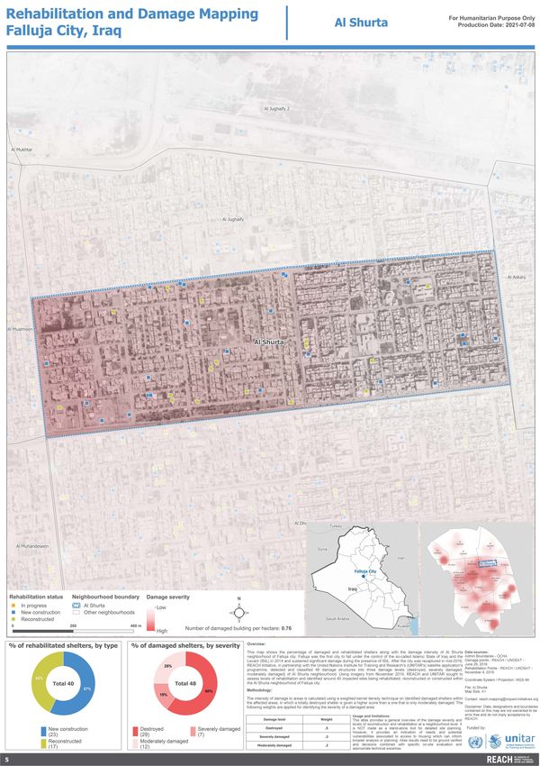
SHELTER DAMAGE ATLAS
Falluja City
Republic of Iraq

Shelter Damage Reference Maps

                                July 2021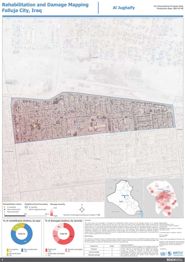
Table of Contents:

Overview                                          01   Shuhada Dhubat                   15

Methodology                                       01   Al Namea                         16

Falluja City - Building Damage per Area Hectare   02   Al Shuhada                       17

Falluja City - Damage Severity mapping            03   Al Jubail                        18

Rehabilitation and Damage Neighbourhoods Maps          Al Muhndeseen                    19
Al Jughaify                                       04   Al-Jamuriya, Rusafi & Muatasem   20
Al Shurta                                         05   Al Mualmeen                      21
Al Julan                                          04   Industrial area                  22
Al Andalus                                        07
Al Risalah                                        08
Al Sakaniya                                       09
Al Jughaify 2                                     10
Al Mukhtar                                        11
Al Nazal                                          12
Al Askary                                         13
Dhubat                                            14
Iraq Shelter Damage Atlas: Satellite Detected Damage, Falluja City
Overview:
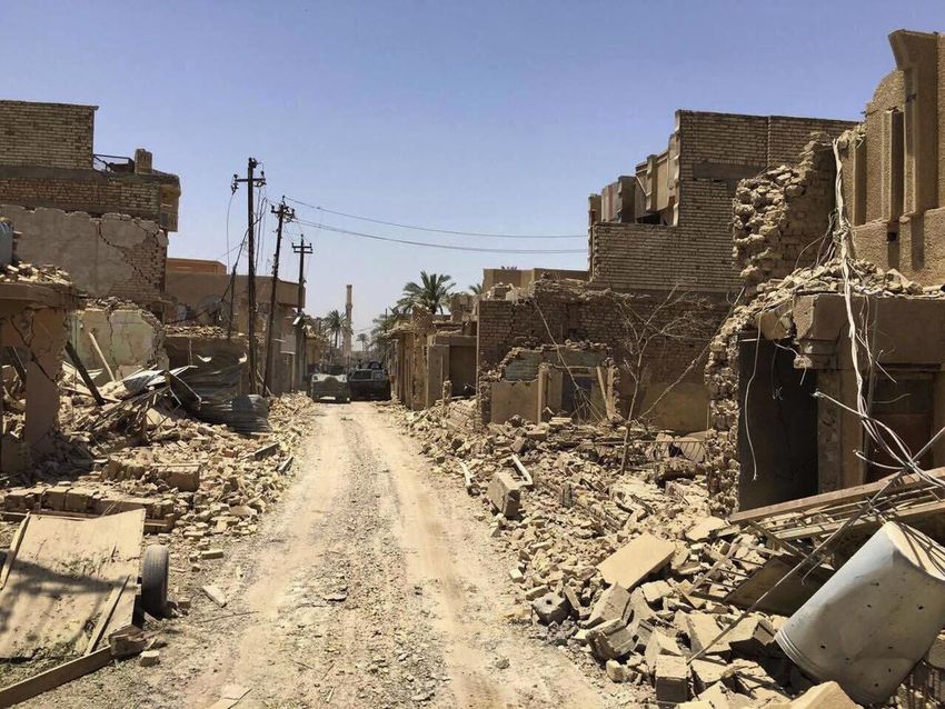
Falluja city, the capital of Falluja district is located in Anbar governorate, 69 kilometers west of Baghdad. It was the first
city to fall under the control of the so-called Islamic State of Iraq and the Levant (ISIL) in 20141. Over the course of the
conflict, the city sustained significant damage, including to shelter and basic infrastructure. After the city was recaptured
in mid-2016, REACH Initiative, in partnership with the United Nations Institute for Training and Research’s (UNITAR’s)
satellite application’s programme, detected and classified 2,648 structures into three damage levels (destroyed, severely
damaged, moderately damaged) for all 19 neighborhoods of Falluja city. Using imagery from November 2019, REACH
and UNITAR sought to assess levels of rehabilitation and identified a round 4 ,278 i mpacted s ites b eing rehabilitated,
reconstructed or constructed.
This atlas therefore presents the scale of damage immediately following the end of military interventions in Falluja with
comparisons based on levels of reconstruction/rehabilitation from 2019.
Methodology:
The shelter damage atlas is developed based on satellite imagery from the Operational Satellite Applications
Programme (UNOSAT) and UNITAR2. Using the satellite imagery REACH detects and classifies structures in urban
areas into three damage levels (destroyed, severely damaged, moderately damaged)3,4. The intensity of damage to
areas is calculated using a weighted kernel density technique on identified shelters within the affected areas, in
which totally destroyed shelter is given a higher score than one that is only moderately damaged. The definition of
damage level and applied weights are given in the following table:
Damage level Definition Weight
Destroyed All or most of the building structure is collapsed (76% - 100% of structure .5
destroyed).
Severely damaged A significant part of the building structure is collapsed (31%-75% of structure .3
destroyed).
Moderately damaged Limited damage observed to the building structure (5%-30% of structure .2
damaged).
Then the data is compared with historical imagery, on damage and destruction (immediately following conflict) in order to
assess the levels of reconstruction and rehabilitation over time5. Rehabilitation status at a neighbourhood level is further
classified into three levels (in progress, under construction, reconstruction). The comparison of levels of destruction/
damage and levels of rehabilitation/reconstruction are then mapped for a visual analysis of the status of housing
infrastructure at a neighbourhood level.
Usage and limitations:
This atlas provides a general overview of the damage severity and levels of reconstruction and rehabilitation at a
neighbourhood level. It is NOT made as a stand-alone tool for detailed site planning. However, it provides an indication
of needs and potential vulnerabilities associated to access to housing which can inform broader analysis or planning.
Atlas results need to be ground verified and decisions combined with specific on-site evaluation and appropriate technical
expertise.
1 - REACH Intitiative - Fallujah City Area - Based Assessment (November 2018 - January 2019). Link available here.
2 - Historical data is generally publicly available. Up-to-date data on the status of infrastructure can be purchased for between 10 and 17 United States dollars (USD) per square
kilometer depending on source / sensor.
3 - WorldView-2 from 29 June 2016. Copyright: ©2016, DigitalGlobe
4 - GeoEye from 30 November 2014, Pleiades from 16 June 2019. Copyright: CNES
5 - WorldView-3 from 04 November 2019. Copyright: ©2019 DigitalGlobe
1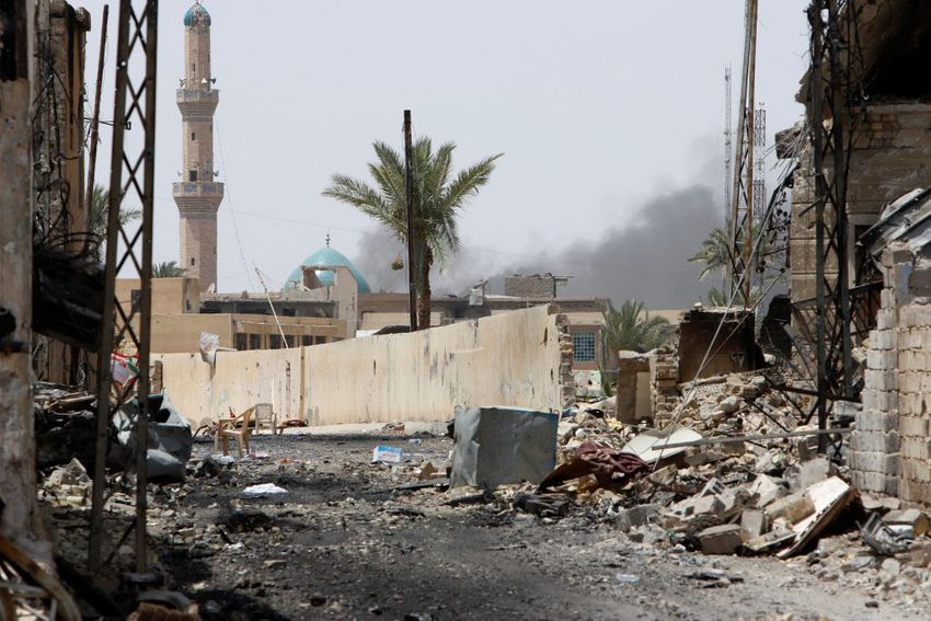
Building Damaged per Area Hectare - as of 29 June 2016                              For Humanitarian Purposes Only
                                                                                                                                      Production date : 23 June 2021
                                                 Falluja City, Iraq

                                                                  Al Mukhtar
                                                                                                     Al Jughaify 2

              Al Sakaniya

                                                                                                Al Jughaify
                                                                                Al Mualmeen        Al Shurta                Al Askary
                                                   Al Julan

                                                                                                         Al Dhubat
                                                                  Al-Jamuriya, Al Muhandeseen
                                                                    Rusafi &
                                                                   Muatasem
                                                                   Al Andalus                            Industrial
                                                                                                           area
                                                                                        Al Nazal
                                                                      Al Risalah

                                                                                                                           Shuhada
                                                                                                                            Dhubat
                                                                                                Al Shuhada
                                                                         Al Jubail

                                                                                                     Al Namea

Data sources:
Admin Boundaries - OCHA
Damage points - REACH / UNOSAT - June 29, 2016                                                                       Number of damaged buildings per hectare
Coordinate system / Projection: WGS 84

File: Falluja Neighbourhoods                                                                                                         0 - 0.5
Map Size: A4

Contact: reach.mapping@impact-initiatives.org
                                                                                                                                     0.6 - 1
Disclaimer: Data, designations and boundaries contained on this                                                                      1.1 - 2.1
map are not warranted to be error-free and do not imply
acceptance by REACH.                                                                                                   0       0.5        1
                                                                                                                                              KM
Damage Severity Mapping - as of 29 June 2016                                  For Humanitarian Purposes Only
                                                                                                                                 Production date : 23 June 2021
                                                  Falluja City, Iraq

                                                                  Al Mukhtar
                                                                                                     Al Jughaify 2

               Al Sakaniya

                                                                                                Al Jughaify
                                                                                Al Mualmeen        Al Shurta           Al Askary
                                                   Al Julan

                                                                                                         Al Dhubat
                                                                  Al-Jamuriya, Al Muhandeseen
                                                                  Rusafi &
                                                                  Muatasem
                                                                   Al Andalus                            Industrial
                                                                                                           area
                                                                                        Al Nazal
                                                                      Al Risalah

                                                                                                                      Shuhada
                                                                                                                       Dhubat
                                                                                                Al Shuhada
                                                                         Al Jubail

                                                                                                     Al Namea               Damage severity

Data sources:                                                                                                                            Low
Admin Boundaries - OCHA
Damage points - REACH / UNOSAT - June 29, 2016

Coordinate system / Projection: WGS 84

File: Falluja Neighbourhoods
Map Size: A4

Contact: reach.mapping@impact-initiatives.org

Disclaimer: Data, designations and boundaries contained on this
map are not warranted to be error-free and do not imply
                                                                                                                                         High
acceptance by REACH.
                                                                                                                            0         0.5          1
                                                                                                                                                       KM
You can also read