Shrewsbury North West Relief Road FAQs 2020 - Shropshire ...
←
→
Page content transcription
If your browser does not render page correctly, please read the page content below
Shrewsbury North West Relief Road FAQs 2020

Overall scheme
What is the NWRR?
The Shrewsbury North West Relief Road (NWRR) will provide a new 60 mph single
carriageway road linking the north and west of Shrewsbury. It will include a new bridge over
the River Severn and its flood plain, and a new bridge over the Shrewsbury - Chester railway
line. The end points of the NWRR have been determined by the existing Battlefield Link
Road in the north, and in the west, at the A5 and Churncote roundabout at Welshpool Road.
Why is the road needed? Which areas will benefit from the road? What are the
benefits of this road?
Traffic between areas to the north and west of Shrewsbury has to pass through the town
centre, rat run through unsuitable roads west of the town or take the significantly longer route
around the A5 / A49 bypass. As a result, there are unacceptably high levels of traffic including
heavy vehicles on residential roads approaching the town centre and within the centre itself
where there is only limited highway capacity. This leads to problems of congestion, delays and
journey unreliability for road users, and problems of noise, poor air quality and reduced
accessibility, public transport services are also affected by congestion.
The North West Relief Road is intended to support the following specific objectives for
Shrewsbury:
• To improve connectivity and accessibility between the north and west of Shrewsbury for
  all modes of transport
• To reduce traffic congestion in Shrewsbury town centre
• To reduce traffic congestion on the A5 / A49 bypass
• To reduce traffic congestion on the north and west approaches to the town
• To improve the reliability of journey times and reduce unforeseen delays
• To improve the efficiency of Shrewsbury’s transport network for all modes of transport
• To improve the resilience of Shrewsbury’s transport network
• To reduce the number of people killed or seriously injured on roads in Shrewsbury
• To improve air quality, especially in the built-up areas of Shrewsbury
• To reduce net emissions of CO2 and other greenhouse gases from vehicles using the
  highway network
• To facilitate the Shrewsbury West Sustainable Urban Extension
• To enhance the benefits of Shrewsbury Integrated Transport Package
• To support Shrewsbury’s Big Town Plan
How long is the scheme?
The scheme is approximately 7 km from Churncote Roundabout to Ellesmere Road.
Why is it taking so long to start work?
A scheme like North West Relief Road requires planning permission and the acquisition of
land, over which the road would pass. Objections to either of these processes could lead to
a Public Inquiry. It is expected that a planning application will be submitted in May 2020 with
a Public Inquiry provisionally programmed for spring/summer 2021.
Why isn’t the NWRR a dual carriageway?
The design process involves testing different standards of road (including dual carriageway)
in the Traffic Model to understand how much traffic would be attracted by the different
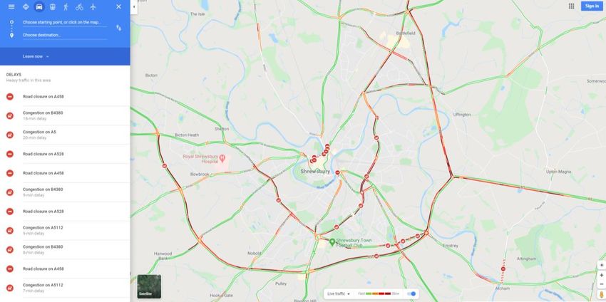
standards of road. When these tests were undertaken it was found that changes to the
standard of road (including dual carriageway) had minimal impact on the amount of traffic
that would use the NWRR. Also, in all cases the maximum flow levels were within the range
of flows that are acceptable (in line with government guidance) for a single carriageway road
standard.
A large proportion of the funding for the NWRR comes from central government and cost
benefit analysis has been undertaken to prove the benefit of the scheme compare favourably
with the costs, and without this it would not have been possible to secure this contribution
from central government. The considerable additional costs involved in constructing a dual
carriageway standard road would significantly reduce this benefit to cost ratio.
Why does a road network need to be resilient?
Most road networks are able to cope with minor incidents which cause a reduction in
capacity, for example a set of traffic signals operating one-way working during public utility
works or road maintenance. To manage this, Shropshire Council operates a permit system
which coordinates, and limits all works on the highway to avoid significant delays. This can
sometimes include restricting works to specific times of the day or preventing works at very
busy times, such as the lead up to Christmas. An example of well-planned works would be to
avoid a situation where road works take place on two parallel routes at the same time,
maintaining maximum capacity on one route while the other is restricted. However, if a road
network is running close to capacity even small incidents can result in significant delays as
traffic moves to alternative routes these roads struggle to cope with the additional traffic. The
construction of new roads in a network will increase overall capacity and increase the
number of alternative routes available when incidents occur. The network will therefore be
more resilient.
The most difficult situations to manage are unforeseen incidents such as major road traffic
crashes or natural disasters. For this type of incident, the only planning that can take place is
for the overall network to be made more resilient by introducing more capacity and more
alternative routes.
The below image shows the extent to which the existing highway network in and around
Shrewsbury struggled to cope with the closure of town centre roads on the 25th February
2020 due to major flooding from the River Severn closing all roads into the town centre.
The NWRR will help to make the Shrewsbury road network more resilient for minor and
major incidents.
Are there any works planned in the town centre?
The Shrewsbury North West Relief Road will complement the Shrewsbury Integrated
Transport Package (SITP) which has or will introduce:
   •   Enhancements to the public realm, such as Pride Hill, Roushill & Mardol
   •   Enhancements to pedestrian and cycle links to increase accessibility to the town
       centre
   •   Improved pedestrian wayfinding within and around the ‘river loop’ to generate a
       highly accessible and connected town centre for pedestrians
Together they will support the delivery of the Big Town Plan by removing significant levels of
traffic from the town centre.
Why aren’t I being given the opportunity to object the scheme?
Whatever your views, you are very welcome to make whatever remarks you would like to
make about the scheme, and Shropshire Council is very happy to receive them. All
comments will be taken into consideration and you may choose to use your answer to
question 12 of the current consultation questionnaire to do so.
The reason why there is not a specific question which seeks a ‘for or against’ response is
that this has already happened, in 2017. Prior to submitting an Outline Business Case to
secure funding, Shropshire Council undertook a public consultation which sought views on
the scheme proposals and specifically asked people to say whether or not they thought the
scheme should be built. 67.5% of respondents agreed that it should be built. This level of
support was taken into account in the decision to submit the Outline Business Case.
Since it was submitted, and the funding secured, there have been some design changes to
certain aspects of the scheme, so Shropshire Council is undertaking a public consultation to
seek feedback on these changes before it submits the scheme for planning permission in
May 2020. Those who wish to object to the scheme will have further opportunities through
the planning process, and their views will be taken into account by the local planning
authority in making its decision.
Who has been consulted with so far?
Public consultations have previously taken place in January/February 2003, May 2005, April 2010 and December 2017. Have alternative options been considered? Alternatives to building a relief road have been considered, including improvements to bus services, improvements to Park and Ride, improvements to the walking and cycling networks and demand management, such as road pricing. However, the results showed that these means alone would not produce the benefits equal to those which could be achieved by building the NWRR. Alternative routes for the relief road have also been considered before the council made its selection of the preferred route. Where can I find the Outline Business Case (OBC)? https://www.shropshire.gov.uk/media/8939/shrewsbury-nwrr-obc-34-web-version.pdf Funding How much will the road cost? The cost of the project is estimated to be £84.3 million when completed in 2024. How will the road be paid for? The Council has secured £54.4 million from the Department for Transport (DfT), The Marches LEP are contributing £4.2 million, Shrewsbury Western SUE developers £8.0 million and the Community Infrastructure Levy £0.7 million. Shropshire Council will be required to fund the remaining £17 million. Where will Shropshire Council find its contribution from? Shropshire Council is currently exploring a number of options including the use of further Community Infrastructure Levy and section 106 developer contributions on the basis that the NWRR is providing traffic reduction across Shrewsbury and thus removing capacity constraints on potential development sites across the town. It is also considering capital receipts and borrowing. Is Shropshire Council committed to building the road? Yes, the Council has accepted the funding allocation from the Department for Transport and is committed to delivering the scheme. The delivery process will still be subject to statutory procedures including planning and a potential public inquiry, and the submission of a full business case to the Department of Transport. Shouldn’t this money be spent on improving the public transport network? (Will other areas in the county receive less funding?) The funding from the Department for Transport (DfT) is only available to construct a North West Relief Road. The funding is not transferable to any other projects in Shropshire. Funding through the Local Transport Plan and other sources will continue to be available to Shropshire for other transport projects.
Traffic
Which year and what scenario do the anticipated traffic changes in the bar graph
represent?
The traffic increases and decreases (presented in the bar graph) are predicted in the 2023
opening year for the "with" NWRR scenario compared to the "without" NWRR scenario. The
same trips / journeys take place on the whole road network in the “with” and “without”
scenarios and the increases and decreases result from changes in the routes taken by these
trips / journeys.
Will the NWRR stop rat running through rural roads from the A5 to north Shrewsbury?
It has been suggested that the NWRR will help to solve cross country rat running between
the A5 and north Shrewsbury. The below table shows the AM peak journey times between
the A5 at Shotatton Cross Roads and the Ellesmere Road/Battlefield Link Road roundabout
via the rural roads and via the A5 & NWRR. It will be 2 minutes quicker to go via the NWRR.
These journey times are consistent with the traffic modelling which predicts a reduction in
traffic on Huffley lane

 From                          To                           Via               Time

 A5 Shotatton Cross            Ellesmere Road               Rural Roads       17.1 mins
 Roads

 A5 Shotatton Cross            Ellesmere Road               A5 & NWRR         15.0 mins
 Roads

Will traffic to/from the A5 west of Shrewsbury use the B4380 via Montford Bridge and
Bicton to access the NWRR at the new Holyhead Road roundabout?
Concern has been expressed about traffic using the B4380 through Bicton to access the
NWRR at the new Holyhead Road roundabout, from and to the A5. The below table shows
the am peak journey times between the A5 Montford Bridge junction and the new Holyhead
Road Roundabout via the B4380 and via the NWRR. The NWRR route is quicker. The
difference in journey time is not very significant so Shropshire Council will monitor the traffic
levels after the NWRR is opened and if traffic is using the B4380 route, proposals will be
developed to discourage this route.

 From                         To                            Via               Time

 A5 Montford Bridge           Holyhead Road                 Bicton            4.3 mins
 junction                     Roundabout

 A5 Montford Bridge           Holyhead Road                 A5 and            4.0 mins
 junction                     Roundabout                    NWRR

Will traffic continue to use Welshpool Road between Churncote roundabout and the
Shelton traffic signals rather than using the NWRR?
Concerns have been expressed about traffic from the A458 Welshpool and A5 will
continuing to use the Welshpool Road to access the town centre rather than using the
NWRR. The below table shows the AM peak journey times between the Churncote
Roundabout and the Shelton traffic signals via the NWRR and via the Welshpool Road. The
NWRR is 1.5 minutes quicker.

 From                         To                           Via              Time

 Churncote Roundabout         Shelton Traffic Signals      Welshpool        3.9 mins
                                                           Road

 Churncote Roundabout         Shelton Traffic Signals      NWRR             2.4 mins

How does the journey between Churncote and the A49/A53 roundabout change with
the relief road in place?
Via the existing A5 bypass the distance is 16.6 km and involves crossing six roundabouts.
Once the relief road has been built the distance will be 9.0 km and involve crossing five
roundabouts.
How will the new housing development plan for Welshpool Road change traffic
levels?
Traffic on Welshpool Road will not increase even with the new housing development as
removed through traffic will be replaced by local traffic from the new development.
What will be the impact on Berwick Road?
There is going to be a small traffic increase on Berwick Road, and although the percentage
increase will be high, this equates to a small number increase of cars on this road. There will
also be maintained Public Right of Way links.
When will the latest traffic modelling data be available?
The latest traffic modelling is available on the 2020 consultation traffic banner. The modelling
is currently being updated, therefore the final flows from the modelling may vary slightly in
the final submission compared to that shown as part of this consultation exercise.
Can the A5 Churncote Roundabout cope with the additional traffic?
The traffic modelling predicts increases at the A5 Churncote Roundabout in traffic on the A5
north approach. These increases are generally linked to the reductions on the B4380
Holyhead Road and in the rural rat running between the A5 and north Shrewsbury as traffic
transfers to a quicker and more appropriate route. It also predicts increases on the A5 south
approach due to traffic re-routing from the south and west of Shrewsbury to access the
NWRR to reach north Shrewsbury. It is important to note that a new roundabout will be
constructed at Churncote which will be designed to cope with the expected levels of traffic
and specifically with these increases.
Can the B4380 (old A5 bypass) between the new Holyhead Roundabout and Roman
Road cope with the additional traffic?
The average peak hour two-way flow on the B4380 Roman Road between Longden Road
and Meole Brace Island is expected to be approximately 1,700 vehicles in 2023 without the
NWRR and this will decrease slightly once the NWRR is opened. The predicted flows on the
remaining section of the old A5 bypass towards Holyhead Road are expected to increase
after the NWRR is opened however, the average peak hour two-way flow is not predicted to
exceed an average peak hour two-way flow of approximately 1,500. Between Longden
Road Roundabout to the Shelton traffic signals. The short section of B4380 between Shelton
signal and the new Holyhead Roundabout will be approximately 1,700 vehicles or 30
vehicles per minute two-way flow. These levels of flow are appropriate for the standard of
road along the B4380 (old A5 bypass) and can be accommodated by the existing Shelton
traffic signals with revised signal timings.
Can Berwick Road (between the NWRR and the Ellesmere Road/Coton Hill traffic
signals) cope with the additional traffic?
The traffic modelling predicts an average peak hour two-way flow increase in traffic on this
section of the Berwick Road of 142% in the opening year. However, this large percentage
increase relates to a relatively low existing flow. The average peak hour two-way flow in
2023 without the NWRR is predicted to be approximately 150 vehicle per hour and once the
NWRR is opened this would increase to approximately 350 vehicles per hour (6 per minute).
For this standard of road this is relative low level of flow and represents a daily flow of
approximately 4,200 vehicles. The increase in traffic on the Berwick Road will not increase
the delays at the Berwick Road / Coton Hill / Ellesmere Road traffic signals because there
will be a significant reduction in traffic on the Ellesmere Road corridor and an overall
decrease in traffic movements at the signal-controlled junction.
A connection between the NWRR and the Berwick Road will benefit those living at the
southern end of Ellesmere Road and in the Coton Hill area by providing a direct and
convenient access onto the main road network.
How many through trips will be removed from Smithfield Road?
A detailed analysis of vehicle movements between the Welsh Bridge and Chester Street
Gyratory has identified that the NWRR will remove over 450 two-way trips in the average
peak hour that go between these locations. The origins and destination of these trips could
be anywhere outside the river loop.
Environmental Issues
General
Why isn’t the EIA (Environmental Impact Assessment) available?
The EIA is still being completed and will be submitted as part of the full planning application
in May – the EIA will then be available to read on the Shropshire Council website. In the
meantime, you may wish to view the Outline Business Case, where there is some
environmental impact information which may be helpful.
What environment studies are being undertaken?
An Environmental Impact Assessment in accordance with the Town and Country Planning
(Environmental Impact Assessment) Regulations 2017 (as amended) is being compiled. This
will accompany the Planning Application and will focus on the following:
• Set the legal framework;
• Document the consultation process;
• Consider the alternatives to the Proposed Scheme;
• Establish the baseline environmental conditions at the Site and within the surrounding
area;
• Identify likely significant effects during the design process so that some effects can be
avoided, prevented, reduced or, if possible, offset prior to the assessments within the
ES;
• Identify potential impacts associated with the Proposed Scheme in relation to the
following topics: Air Quality, Agriculture and Soils Resources, Biodiversity, ClimateChange, Geology and Soils, Historic Environment, Landscape and Visual, Major
Accidents and Disasters, Materials and Waste, Noise and Vibration, Population and
Health and Road Drainage and Water Environment;
• Identify suitable essential mitigation measures to avoid, prevent, reduce or, if possible,
offset the identified potential impacts on the environment and identify the likely significant
residual effects following the implementation of these measures;
• Identify monitoring measures where likely significant residual effects are identified; and
• Identify, predict and qualitatively assess the cumulative effects of the Proposed Scheme
including those associated with the other identified committed developments and those
associated with the inter-action between the above-mentioned environmental topics.
The scope of the EIA has been determined through consultation with statutory and non-
statutory environmental bodies during the EIA Scoping Stage and full details can be found
at:
https://pa.shropshire.gov.uk/online-
applications/applicationDetails.do?activeTab=summary&keyVal=Q0YK55TD08C00
A Water Framework Directive (WFD) will be undertaken as the NWRR crosses the River
Severn which is a Main River in order to assess the potential works against the objectives of
the WFD. In addition, and due to the location of the Proposed Scheme in close proximity to
the following European/internationally designated sites, an HRA is required and will
accompany the ES:
• Midland Meres and Mosses (Phase 2) Ramsar (located at approximately 50m west of
the Site);
• Midland Meres and Mosses (Phase 1) Ramsar (located at approximately 6.5km south of
the Site); and
• Tanat and Vyrnwy Bat Sites (Special Area of Conservation) (located at approximately
30km south of the Site)
Noise
Where is the noise increases and decreases?
Operational noise and airborne vibration are directly related to traffic flows. Where the
proposed route runs close to residential properties and other sensitive receptors, these are
likely to experience increase in the noise levels. For existing routes which are “bypassed” by
the scheme, a reduction in traffic flows is expected which would result in a reduction in traffic
related noise and vibration.
Noise modelling, with and without the Scheme in place is currently being undertaken to
determine potential increases and/or decreases in noise levels at dwellings and other
sensitive receptors, e.g. schools, hospitals and churches and this will form part of the
Environmental Statement.
What will be the noise level at my house?
At this stage, noise levels at individual properties are not yet available. We are currently in
the process of modelling noise levels at dwellings and other sensitive receptors using
predicted traffic levels, with and without the Scheme in place. Traffic noise level predictions
will be included in the Environmental Statement to support the planning application.
How will noise be mitigated for the high-level bridge across the River Severn?We will have to wait until we have made more detailed calculations, for example for the nearby properties at Dalton Drive, to see what would be feasible and cost effective. What is the implication of the recent Court of Appeal ruling on the third runway at Heathrow on the NWRR? The Court of Appeal ruled that the national policy statement (ANPS) backing Heathrow’s expansion was unlawful as it failed to CONSIDER THE IMPACT on the UK’s obligations under the 2015 Paris Agreement. Lord Justice Lindblom told the court: “The Paris Agreement ought to have been taken into account by the Secretary of State in the preparation of the NPS and an explanation given as to how it was taken into account, but it was not.” In the context of North West Relief Road (NWRR), members of the SC Planning Committee will make the decision on whether to approve or refuse an application for the NWRR. In doing so they may take into account any material considerations of relevance to the planning application. One such consideration may be whether the proposed scheme conflicts with the UK’s ability to comply with the commitments of the Paris Agreement 2015. On this basis, there is an onus on the applicant to demonstrate there would be no such conflict. Also, notwithstanding Shropshire Council’s own commitment to achieving net carbon zero by 2030, which Members agreed as part of the Climate Change Strategy Framework in December 2019. One of the objectives set out in the Outline Business Case (OBC), for the NWRR, which was issued in December 2017, is to “contribute towards a reduction in greenhouse gas emissions”. The analysis included in the OBC predicts that the proposed scheme will lead to an overall reduction in greenhouse gas emissions, compared with the “Do Minimum” situation. The Environmental Impact Assessment (EIA) currently being undertaken for the NWRR will include updated predictions of greenhouse gas emissions generated by the proposed scheme. Both embodied carbon during construction and operational carbon will be considered. The EIA will also consider the proposed scheme’s vulnerability and resilience to the effects of climate change. The Board of the NWRR has already commissioned a further study in respect of assessing the carbon performance of the new road in terms of both embodied carbon (i.e. construction) and operational carbon effects. The work is still at its data gathering phase and further data and evidence will be provided for consideration in due course. It does need to be stated that the report has already been commissioned via WSP / Balfour Beatty, in addition to the evidence base and existing data that forms the original business case for the NWRR. The study is due to be completed during the Spring and will be subject to acceptance or challenge by the NWRR Board. Shropshire Council is firm in its commitments to tackling climate change and becoming carbon neutral by 2030. The NWRR has a role to play in this by reducing through journeys passing through Shrewsbury town centre hence reducing emissions from stationary and slow-moving vehicles. The NWRR proposals have been amended to protect ecologically important sites and the proposals include green infrastructure to enable and encourage journeys by pedestrians and cyclists between north and west Shrewsbury. Will my house be eligible for noise insulation? This cannot be confirmed at this stage as the noise modelling is being undertaken. Applicability for noise insulation is assessed with the scheme operational using real traffic
level figures to assess changes in noise levels at individual properties. To qualify under the
Noise Insulation regulations:

• the property must be residential
• the property must be within 300 m of the new or altered road
• have been occupied before the new or altered road was first opened to the public
• predicted traffic noise levels at one or more facades must increase by at least 1 dB(A)
  and be not less than 68 dB LA10,18h
• traffic on the new road must contribute at least 1 dB(A) to the overall future noise
• subject to the above criteria being satisfied, the following rooms will be eligible for noise
  insulation provided they have one or more facades exposed to the noise: living room,
  dining room, study, bedsitter, bedroom

What about Construction Noise?
Appropriate noise and vibration mitigation measures will be outlined in the Noise and
Vibration ES chapter and in the Construction Environmental Management Plan (CEMP) that
will accompany the planning application. These will be based on the principles of Best
Practice Measures and are likely to include, but are not limited to, the following:

• Maintain good public relations with residents that may be affected by noise and
  vibration from the NWRR
• Careful planning of construction activities and selection of appropriate plant to
  reduce noise emissions
• Shutting down equipment when not in use
• Use of temporary barriers to screen noisy activities

Will traffic noise affect Hencott Pool or other wildlife?
No. Hencott Pool is designated because of its plant life. Disturbance by traffic noise can
affect wildlife species and this potential effect will be considered as part of the Biodiversity
ES Chapter.

Wildlife
What wildlife crossing will be provided?
The following wildlife crossings are currently proposed for the scheme:

    Location                                   Type of crossing

    South of Oxon Pool                         This is currently a water culvert, but
                                               consideration is being given to making
                                               provision for amphibian tunnel(s) in the
                                               surrounding area.

    Between Holyhead Road and the River        Pedestrian, equestrian and mammal (bats and
    Severn viaduct                             badgers) underpass

    East of the River Severn Viaduct           Badger tunnel

    Willow Pool                                Proposals are being reviewed due to the need
                                               to realignment of the route in this location.
West of Berwick Road Badger tunnel South of Alkmund Park Wood Ancient Culvert and wildlife corridor (bats and badgers) Woodland South of Hencott Wood Culvert and wildlife corridor (bats and badgers) Air Quality Will there be an overall improvement/deterioration in local air quality? What does this mean? Vehicle derived emissions are a main contributor to the concentrations of oxides of nitrogen (NOx), nitrogen dioxide (NO2) and fine particulate matter (PM10 and PM2.5) in the UK which can in turn affect human and ecological receptors. Improvements would occur where there are traffic reductions and deterioration where there is a traffic increase. Traffic speeds are also taken into account, providing some measure of the reduction in congestion and delay. Traffic congestion has an adverse impact on air quality. We are using current and predicted traffic data to model changes to local air quality. The scheme aims to provide traffic relief on existing roads in Shrewsbury which is likely to improve local air quality in these areas. Can this improvement be quantified? Air quality modelling, with and without the Scheme in place is currently being undertaken The air quality impact assessment will be based upon changes in traffic flow and provides a measure of people’s relative exposure to pollutants, both with and without the scheme, taking into account the number of properties within various distance bands up to 200m from an affected road and the anticipated Annual Mean concentrations of NO2 and PM10 within each band. The board indicates that there would be both improvements and deterioration for people depending on traffic changes. What does this mean? Where is the deterioration? Improvements would occur where there are traffic reductions and deterioration where there is a traffic increase. Traffic speeds are also taken into account, providing some measure of the reduction in congestion and delay. Traffic congestion has an adverse impact on air quality. Previous modelling in 2017 identified that any changes are likely to be minor in terms of magnitude. There was some relative deterioration (against a background of declining emissions in any event) for: • Roads feeding into Battlefield Roundabout, including Harlescott Lane • Holyhead Road / Shelton Road The air quality modelling is currently underway, and the results will be reported in the Air Quality ES chapter.
Why are numbers of properties not confirmed for Local Air Quality, as they are for
Noise? What are the numbers of properties?
As confirmed above the result of the local air quality appraisal is a combination of numbers
of properties and relative concentrations for pollutants.
In 2017 is was predicted that, on balance, there would be an improvement.
This work is currently being updated and furthermore detailed assessments will be carried
out as part of the EIA.
What is an AQMA? What are the implications for NWRR?
The Council have defined Air Quality Management Areas where the existing concentration of
pollutants exceed Government Thresholds. Both the Town Centre and Heathgates
Roundabout exceed the threshold of 40 micrograms of NO2 per cubic metre.
An objective of the scheme is to contribute towards improved air quality for people in
Shrewsbury with the aim to move traffic and congestion away from existing problems in
Shrewsbury. Such improvements are particularly important within an AQMA.
What is the pollution concentration at my house?
Detailed calculations are not available at this stage, but as part of the EIA a more detailed air
quality assessment will be carried out, which will confirm concentrations at selected
properties with and without the Proposed Scheme in place.

Greenhouse Gases
NWRR will add to climate change by increasing the amount of traffic?
In 2010 it was predicted that carbon emissions would increase by approximately 10% over
60 years with or without the NWRR. However, we are currently using updated traffic data for
the NWRR and applicable guidance to undertake up to date predictions in changes in
greenhouse gas emissions.
What exactly is the contribution of NWRR to traffic emissions of carbon?
We are currently using updated traffic data for the NWRR and applicable guidance to
undertake up to date predictions in changes in greenhouse gas emissions.
Has the construction process been taken into account?
Not at this stage, but it will be for the EIA, an assessment on the use of materials and its
carbon footprint. Wherever possible secondary materials would be used.

Landscape
What is the impact on the landscape?
It is recognised that the construction of NWRR across open countryside is likely to affect
receptors such as Berwick Park, which is now a registered park and garden of historic
interest and landscapes associated with the National Character Area 61 - – Shropshire,
Cheshire and Staffordshire Plain.
A detailed landscape and visual impact assessment are currently being undertaken; the
results of which will be reported in the ES.
How will the Council guarantee these measures will be delivered?
They were delivered successfully for the A53 Hodnet Bypass.
The Council will be appointing a Contractor to develop the proposals using the exhibited
proposals as a basis. Although changes to the plans may be made, the quality of the
contractor’s proposals will need to be at least equal to or better than those exhibited to be
acceptable.
The landscape and environmental proposals will be included in the planning application and
the formal orders for the project. Where necessary land will be included in the CPO to
ensure delivery. The proposals will also be described in the Environmental Statement. Both
the ES and any conditions applied to a planning consent will represent a binding
commitment.
As at Hodnet the landscape proposals will be implemented on site by a specialist contract
under the direct control of the Council.

Townscape
What are the townscape effects of the NWRR?
It is expected the scheme will result in reductions in traffic in the town, including the
Conservation Area will result in overall benefits for townscape, by reducing the visual
intrusion and potential adverse effects on amenity resulting from high traffic flows.

Nature Conservation
How can it be acceptable to place the route for NWRR so close to Hencott Pool which
is of international significance?
The location of the route and the implications has previously been considered in consultation
with Natural England. The NWRR has been re-aligned to 200m south of Hencott Pool with
the intention of avoiding potential operational air quality impacts on the Midland Meres &
Mosses - Phase 2 Ramsar. Potential impacts on this site during the construction and
operation of the NWRR will be detailed in the Biodiversity ES chapter.
What other effects would there be for wildlife?
The impact assessment which is currently underway will focus on the following:
Potential impact on the following statutory designated sites during construction and
operation:
       • Midland Meres and Mosses Phase 2 Ramsar – Hencott Pool (European site)
       • Hencott Pool SSSI, Old River Bed SSSI and the Alkmund Wood Ancient
            Woodland sites
Potential impact on the following priority habitats during construction and operation:
       • Broadleaved semi-natural woodland
       • Mixed semi-natural woodland
       • Dense/continuous and scattered scrub
       • Standing Water
       • Running water
       • Scattered broadleaved trees
       • Hedgerows (intact, species poor and intact, species rich)
       • Wet woodland
Potential impact on the protected and notable species following priority habitats during
construction and operation:
• Badger
• Bats (foraging and roosting, all species)
• Breeding Birds (all species)
• Brown hare
• Amphibians including GCN and common toad
• Harvest mouse
• Hazel dormouse
• Hedgehog
• Riparian mammals: otter and water vole
• Reptiles
• Terrestrial invertebrates
• Aquatic invertebrates
• Fish
Potential impact relating to Invasive species (Himalayan Balsam) on the protected and
notable species following priority habitats during construction and operation.
The impact assessment will be informed by the results of ecology surveys that were
previously undertaken for the legacy NWRR and OLR schemes and additional ones that
were undertaken from July 2019 until Match 2020.
How will the ecological measures be managed in the longer term?
The contract will include a five-year aftercare period to ensure that all measures are properly
established before handover for the council’s long-term management.
The design of features will ensure that habitats are relatively maintenance free, for example
by using low nutrient soils, to minimise the need for intervention. All areas will be handed
over to the Council with a long-term environmental management plan.
Heritage of Historic Resources
What is the effect on Berwick Registered Park and Garden?
The route of NWRR remains outside the designated area. There would be views from the
park, and the area immediately surrounding the hall, of the high-level river crossing. There
would also be some views of the route crossing the agricultural landscape to the south of the
Park.
It would be difficult to hide the bridge completely, particularly in the short term, but offsite
planting carried out within the Park could have an effect over the longer term. Views of the
route to the south, including those from the entrance lodges can be mitigated by a
combination of planting and earth mounding.
What is the effect for built heritage within the town?
On balance it is expected that the listed buildings, scheduled monuments and Conservation
Area would benefit from reduced traffic, reducing visual impact and adverse environmental
conditions. However, impacts will be assessed fully, and any mitigation proposed as part of
the planning application.Archaeology What is the Berwick Cropmark Complex and what effect does NWRR have? The complex is a collection of archaeological features recorded on the Shropshire Historic Environment Record. The archaeological site was first identified on aerial photographs and comprises features suggestive of prehistoric or Romano-British activity, including enclosures, ring ditches and linear features, which were potentially of national significance. Archaeological work in 2007, comprising geophysical survey and trial trenching, investigated the nature, survival, date and significance of the Berwick Cropmark Complex. Although the geophysical survey confirmed the location of some of the archaeological remains visible from the air, the subsequent trial trenching suggested that the majority of features located within the footprint of the NWRR have been removed or truncated by agricultural activity. Further archaeological work will be undertaken as part of the delivery of the NWRR to ensure that any surviving archaeology is preserved by record. Water Why is a shorter River Severn viaduct being proposed? The NWRR project is looking at all opportunities to reduce costs and the risk of cost increases. The construction of the road on part embankment part viaduct offers cost savings and reduced risks in terms of the construction of the road and may help to provide additional benefits in the future if the structure is further developed for water management. What impact will the proposed shorter viaduct and extended eastern embankment to the River Severn crossing have on the flood plain? Initial flood plain modelling has indicated that flood levels immediately upstream will not increase by more than 200mm and the increases do not extend as far as Montford Bridge. The increase in the extent (area) is not expected to be significant as the floodplain is fairly constrained in this section of the Severn Valley, but accurate information is not yet available. More detailed analysis is being carried out to support the Flood Risk Assessment for the planning application which will include mapping of the flood extents, but this work will not be completed until the end of March 2020 at the earliest. This analysis will make use of a new model produced by the Environment Agency for the River Severn, including more recent hydrology and channel bathymetry. The modelling will help determine the acceptability of any increase in flood risk as a result of the extended embankment in the floodplain. With this information, WSP and Shropshire Council will work with the EA to assess the impacts and benefits of the shorter viaduct and will also undertake robust environmental assessments in order to minimise adverse impacts while maximising environmental and flood risk benefits. Is a flood alleviation scheme being proposed north of Shrewsbury? The recently formed River Severn Partnership has the full support of the three counties and local authorities along the river corridor, and also the Environment Agency, Natural Resources Wales and Water Resources West. Its purpose is to work collaboratively to deliver a comprehensive long-term approach to water management along the River Severn which stimulates sustainable growth and supports environmental betterment and climate resilience. By adopting a catchment scale approach, the Partnership will seek to maximise benefits from investments in large scale development and infrastructure projects throughout the catchment. Recent press coverage has indicated the Partnership’s aspirations for a flood
alleviation scheme north of Shrewsbury and has made links between this proposal and the
North West Relief Road (NWRR). While there are potential synergies with the NWRR it is
important to note that a flood alleviation scheme would be subject to a separate
development, consultation, approval and delivery process.
What are the implications for the public water supply at Shelton?
There are two aspects:

•   the source protection zone for boreholes
•   the surface water intake for the River Severn
The route cannot avoid the SPZ. However, the water bearing strata are well below the road
level and the risk of contamination is remote. The drainage system would be sealed to
minimise any risk of contamination from the surface – including accidental spillage.
The route is deliberately placed downstream of the surface water intake, 100 metres
approximately, to minimise the risk of contamination. Bridge parapets would be designed to
minimise the risk of vehicles entering the river.
The hydrogeological impact assessment is currently underway, and it will detail any potential
impacts and applicable mitigation measures during construction and operations. These will
be informed by the ongoing consultation with Severn Trent Water.
What will be done to prevent flooding and contamination of watercourses in general?
All drainage outfalls from the road would be via drainage ponds designed to:

•   hold back storm run-off and release it at a greenfield rate
•   catch and treat contaminants, both in routine conditions and in the case of an
    accidental spillage
Will the adjacent cutting drain Oxon Pool?
No. This will be studied in detail at the next stage and the drainage designed to avoid
drawing down the pool. If necessary, an impermeable cut-off wall would be provided.

Vulnerable Users
Will the proposals create severance for vulnerable users?
Some existing public rights of ways = will be severed during construction and operation.
Temporary diversions are proposed, and these would be clearly advertised prior to
commencement of works, with clear signage and contractors will liaise with residents and
user groups prior to works to ensure that contractors act considerately in relation to local
residents. Permanent closure of PRoW’s would be avoided, where possible. Where
avoidance of permanent PRoW closure is not possible, a permanent signed diversion should
be in place and permanent closure measures would be carried out in consultation with the
local highway’s authority and other interested stakeholders
At the same time there would be provision for a new shared footway/cycleway along the
length of the NWRR. Appropriate levels of direction signage will be provided at key points.
This new provision:

•   creates a new route across the river
•   creates opportunities for more circular walks in and out of the town by connecting up
    existing routes
Public Right of Way and Equestrians
What provision will be made for equestrians?
Between the River Severn & Ellesmere Road there are no existing bridleways and the
scheme does not propose any new provision for equestrians in this area.
It is not feasible to take horses across the high-level viaduct over the River Severn.
Between Holyhead Road and the River Severn there are two existing bridleways,
Featherbed Lane and Shelton Lane. The scheme proposes an equestrian underpass on this
section of the new road which will provide an off-road link between Featherbed Lane and
Shelton Lane. Currently equestrians have to use approximately 120m of verge on the east
side of Holyhead Road if they want to travel from Featherbed Lane to Shelton Lane or vice
versa.
Between Holyhead Road and Churncote Roundabout there are no existing bridleways.
However, the equestrians who travel along Calcott Lane and/or Shepherd’s Lane between
Holyhead Road and Welshpool Road will be provided with new bridleway links (north of the
new road) between Calcott Lane and Shepherd’s Lane and between Shepherd’s Lane and
Clayton Way. Clayton Way overbridge will include equestrian parapets.
What changes are planned for the public right of way network?
Some existing public rights of way will be severed but diversions are proposed and include:
• The public footpath that runs southeast/northwest from Welshpool Road (near Gains
Park Way) to Calcott Lane will be diverted over the new foot/cycle overbridge east of
Shepherd’s Lane
• The public footpath that runs north/south from Welshpool Road (opposite Ego at The
Grapes) to the grounds of The Severn Hospice will be diverted to the new Clayton
Way overbridge
• Severn Way (between Holyhead Road and the River Severn) will be diverted to a
new underpass
• The provision of a cycle/footway along the south side of the new road will create
circular routes, including linking to an existing public right of way (from Gravel Hill to
Laundry Terrace) that is currently a dead end
• Marches Way to the east of Hencott Wood will be diverted south of Hencott Wood
and across the new railway bridge to an overbridge crossing of the new road
immediately west of the Shrewsbury – Chester Railway Line
Street Lighting
Can I see the street lighting provision of the scheme?
Lighting overview
All existing sections of road that are lit will remain as lit. Street lighting has been provided at
all roundabouts extending to the connecting on/off-line elements in line with relevant
standards.Cycleway and footway provision overview: A combined footway/cycleway has been provided along the whole length of the NWRR and improvements have been made to the existing facilities across the scheme. Churncote Roundabout: Lighting: Churncote Roundabout will remain lit as existing. Cycleway and footway provision: Cycleway and footway provision have been provided between the A458, the proposed NWRR and Welshpool Road. Crossing points will be via splitter islands with dropped kerbs and tactile paving. Cyclists travelling to and from Welshpool Road will have on/off provision on the Welshpool Road arm. Shepherd’s Lane Overbridge Cycleway and footway provision: The proposed Shepherd’s Lane overbridge will provide cycleway and footway provision between the north and south of the road. Clayton Way Overbridge: Lighting: Clayton Way Overbridge will be lit as per the existing. Cycleway and footway provision: Clayton Way overbridge will include a combined footway/cycleway as per the existing arrangement. Holyhead Road Roundabout: Lighting: Lighting will be provided at Holyhead Road Roundabout tying into the existing lit section south of the roundabout. Cycleway and footway provision: Cycleway and footway provision have been provided on all arms of Holyhead Road roundabout. Crossing points will be via splitter islands with dropped kerbs and tactile paving. Cyclists travelling along Holyhead Road (National Cycle Route) will be provided with on/off provision before and after the roundabout. Equestrian Culvert (East of Holyhead): Timed lighting will be provided at the equestrian underpass east of Holyhead. Berwick Road Roundabout
Lighting: Lighting will be provided at Berwick Road Roundabout. Berwick Road is currently
unlit.
Cycleway and footway provision:
Cycleway and footway provision have been provided on all arms of Berwick Road
roundabout. Crossing points will be via splitter islands with dropped kerbs and tactile paving.
Cyclists travelling along Berwick Road will be provided with on/off provision before and after
the roundabout.
Ellesmere Road Roundabout
Lighting: Ellesmere Road Roundabout will remain lit as existing
Cycleway and footway provision:
Cycleway and footway provision have been provided on all arms of Ellesmere Road
Roundabout. Crossing points will be via splitter islands with dropped kerbs and tactile
paving.
Consultation Health and Safety
With an increase in numbers of those infected by the Coronavirus, will the 2020
NWRR consultation events still go ahead?
We are adhering to all the current available advice from Public Health and the NHS and are
continuing to monitor the situation daily. Current advice is to use soap and water to wash
hands frequently. Hand sanitiser gel will be available for use by staff and visitors at all
events.
You can also read