Marine Traffic in the Arctic - ARHC2-04C - A Report Commissioned by the Norwegian Mapping Authority
←
→
Page content transcription
If your browser does not render page correctly, please read the page content below
ARHC2-04C

Marine Traffic in the
Arctic
A Report Commissioned by the Norwegian
Mapping Authority

Analyse & Strategi
Postboks 265 Skøyen
0213 Oslo
Contents:
Foreword ................................................................................................................................................. 3
1      The Marine Traffic Corridors of the Arctic Ocean ........................................................................... 4
    1.1        The Northeast Passage (NEP) and the Northern Sea Route (NSR) .......................................... 5
    1.2        The Northwest Passage (NWP)................................................................................................ 7
    1.3        Connecting Corridors............................................................................................................... 9
2      Operational Conditions and Marine Traffic in the Arctic Ocean ................................................... 11
    2.1        Physical Characteristics of the Northeast Passage ................................................................ 11
    2.2        Physical Characteristics of the Northwest Passage ............................................................... 13
3      Marine Traffic Patterns in the Arctic – Three Types of Traffic Concepts ...................................... 15
    3.1        Current and Expected Marine Traffic on the Northeast Passage .......................................... 16
    3.2        Current and Expected Marine Traffic on the Northwest Passage ......................................... 18
    3.3        Cruise Traffic.......................................................................................................................... 19
4      Recommendations......................................................................................................................... 22
    Appendix A: ....................................................................................................................................... 23

Marine Traffic in the Arctic – Commissioned by the Norwegian Mapping Authority                                                                    Side 2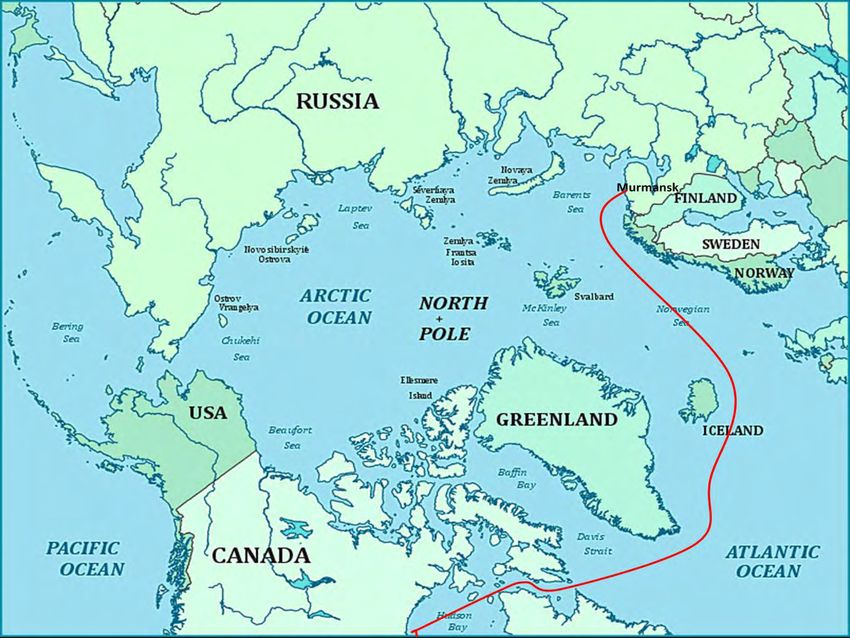
Foreword

This report is produced by Adviser, Karl Magnus Eger at Analyse & Strategi AS on behalf of the Nor-
wegian Mapping Authority. The study is empirical and highly fact oriented, based on secondary ma-
terial stemming from INSROP, AMSA, ARCOP etc. All of which have a broad focus on Arctic shipping
and the challenges related to transportation in these waters. Further recommendations for in depth
studies are presented in chapter 4 of this report.

Oslo, 15. August 2011

Marine Traffic in the Arctic – Commissioned by the Norwegian Mapping Authority                Side 3
1 The Marine Traffic Corridors of the Arctic Ocean1
The Northeast Passage (NEP) and the Northwest Passage (NWP) are often perceived as coastal sea
lanes, connecting ports in the Pacific and the Atlantic, whereas the Trans Polar Passage is assumed to
be a mid-ocean route across the North Pole to and from ports in the Pacific and Atlantic.
                                                           2
Figure 1: The Arctic Ocean with Transportation corridors

Due to the presence of sea ice neither of these transportation passages can offer ships a single set
channel to follow. In practice, ships are forced to follow the channel that offers the best ice and navi-
gational conditions at any one time and place. Thus, each and one of them are more like broad
transportation corridors stretching out in the North-south direction, containing several alternative
navigational channels and fairly huge expanses of ice infested waters. The corridor feature of these
passages implies that they occupy broad stretches of waters that under certain specific circums-
tances and on occasions make them overlap and interact. In sum, the three corridors occupy the
whole of the Arctic Ocean, which covers an area of 14.75 million square kilometers and carries a vo-

1
    This report is compiled by Karl Magnus L. Eger, Analyse & Strategi AS, (www.analysestrategi.no)
2
    Mapping solutions, Lawson Btrigham, USARC Anchorage 2006

Marine Traffic in the Arctic – Commissioned by the Norwegian Mapping Authority                        Side 4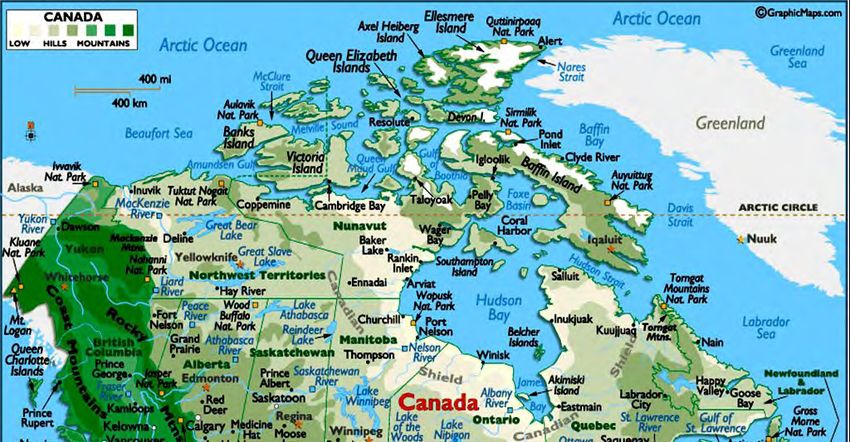
lume of 18 million cubic kilometers of water.3 This report will not focus on the Trans Polar Passage.
No commercial cargo ship has yet crossed the central Arctic Ocean. There are huge uncertainties as
well as variations between different climate models trying to predict the development of ice condi-
tions. In terms of any regular shipping on these routes, however, simulations indicate that the ice will
be too heavy and the calculated costs too high for any regular transport. Models indicate that the ice
conditions will continue to be heavy during winter and spring seasons, even in 2050, and the route is
not expected to be completely ice free in summer. 4
In terms of operating conditions and shipping opportunities, both the NEP and the NWP faces large
water depth variations and complex archipelagos which put constraints on the technical construction
and capacity of the vessels operating on these corridors. Moreover, the sea ice conditions vary signif-
icantly both between and within each of the three passages presenting different challenges to navi-
gation on the NEP and the NWP. From a navigational point of view, the NWP will be the last area
where the multiyear ice will disappear and shipping through this Passage will remain risky even in the
summer season. Currently, the NEP seems to offer the best operating conditions for commercial
shipping activities during summer season.5
The purpose of the following sections is threefold: Firstly, to examine the NEP, the NWP and
connecting corridors on the basis of their geographical features, their interrelations and eventual
overlaps. Secondly, to consider the transportation routes in light of climate change and various
physical characteristics (i.e. narrow straits, depth restrictions and alternative traffic routes). Third-
ly, to give an overview of current and expected traffic patterns on the Arctic sea routes. This section
will also add an overview of Arctic Cruise traffic.
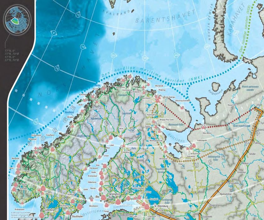
1.1 The Northeast Passage (NEP) and the Northern Sea Route (NSR)
According to political perception and legal regulations in Russia6, the NSR stretches from Novaya
Zemlya in the west (meridian 168 degrees 58 minutes and 37 seconds west) to the Bering Strait in
the east (parallel 66 degree north) (see Figure 1 and 2). The establishment of the NSR as a separate
part of the NEP was decided by the Council of People’s Commissars of the USSR on 17 December
1932, which marks the beginning of the NSR as an administered, legal entity under full Soviet jurisdic-
tion and control. It comprises the main part of the NEP which, with the addition of the waters of the
Barents Sea, connects the Atlantic and Pacific Oceans along the entire length of the northern coast of
Eurasia. The NSR is a series of different sailing lanes, and ice conditions at any one time and place will
decide the sailing course to be set. The route covers some 2200 to 2900 nautical miles of ice-infested
waters. It consists of a series of marginal seas – the Kara Sea, the Laptev Sea, the East Siberian Sea
and the Chukchi Sea – which are linked by some 58 straits running through three archipelagos – the
Novaya Zemlja, the Severnaja Zemlja and the New Siberian Islands (see Figure 2). 7
3
Østreng (2010), p. 25-26
4
Det Norske Veritas, Arctic Container Project, (2009)
5
Eger (2010), p. 275
6
Правила плавания по трассам северного морского пути, утвеждены Министерством морского флота
СССР 14.09.1990. (Regulations for Navigation of the Sea Ways of the NSR of 1990)
7
Østreng (2010), p.26-32
Marine Traffic in the Arctic – Commissioned by the Norwegian Mapping Authority Side 5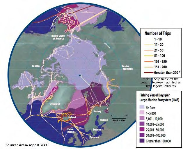
8
Figure 2: Map of the Northern Sea Route

                                                                        New
                                                                        Siberian
                                                     Severnaya Zemlja   Islands

                                     Novaya Zemlja

At times, surface vessels operating in convoys are forced to proceed north of the large island masses
due to the accumulation of pack ice in the straits9, which may be clogged with sea ice. Ice conditions
are in general more difficult along the eastern extremity of the route than in the west. The eastern
sector is also the part of the route with the most shallow shelf areas. The East Siberian Sea has an
average depth of 58 meters and the Chukchi Sea of 88 meters. The shallowness of the shelf is the
most pronounced in the straits, with minimum depths of 8 meters.10 This affects the size; volume and
draft of ships. The ocean areas west of the Yamal Peninsula are fortunate in having a slightly deeper
shelf and lighter ice conditions in average than the eastern sector. This is partly due to the circums-
tance that the Kara Sea is to the north surrounded by several archipelagos (See figure 2), which
usually prevent heavy multi-year ice from the Central Arctic Ocean from penetrating into these wa-
ters. Multi-year ice, which is extremely hard and consequently a serious obstacle to navigation, has
survived the summer melt season and is typically 1 to 5 meter thick.11 The eastern sector lacks this
kind of land protection and is more open to the influx of multi-year ice from the Central Arctic Basin.
However, even in the East ice conditions are changing due to global warming. Here, new extreme
minima of summer ice extent have been established repeatedly ever since 1979.12 However, during
the resent summer seasons large tankers, as the Panamax tankers chartered by the Russian gas com-
pany Novatek, are now using the route north of the New Siberian Islands. This route makes it possi-
ble to use tankers with a draught of over 12 meters 13

8
  Source: INSROP (1999)
9
  Jørgensen (1991), pp. 77-89
10
   Brubaker and Østreng (1999)
11
   AMSA (2008), p. 178
12
     Weller (2000), p. 43, AMSA (2009), p 23
13
     www.barentsobserver.com (august 2011)

Marine Traffic in the Arctic – Commissioned by the Norwegian Mapping Authority                  Side 6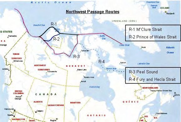
1.2 The Northwest Passage (NWP)
The Northwest Passage is the name given to a set of marine routes between the Atlantic and Pacific
Ocean, spanning the straits and sounds of the Canadian Archipelago, the Davis Strait and the Baffin
Bay in the east and the Beaufort Sea in the west. Like the Northeast Passage it is a transportation
corridor channeled through islands occupying broad expanses of water and land in the north-south
direction. The base of the archipelago stretches some 3000 km along the mainland coast, and the tip
of Ellesmere Island is less than 900 km from the geographic North Pole. The Archipelago is one of the
largest in the world and consists of a labyrinth of islands and headlands of various sizes and shapes.
There are 73 major islands of more than 50 square miles in area, and some 18 114 smaller ones.14 If
islets and rocks are included, the Archipelago comprises approximately 36 000 pieces of dry land
above sea level, making it one of the most complex geographies on Earth.15
         The Canadian Archipelago is subdivided into two main parts by the Parry Channel: the north-
ern part consists of the Queen Elisabeth islands, whereas the southern part comprises all islands
located north of the Canadian mainland and south of the Parry Channel. Thus, the most troublesome
part of the NWP, as seen from a mariner’s point of view runs through a continuous archipelago with
narrow straits often jammed with impenetrable multi-year sea ice drifting in from the Central Arctic
Ocean.
                                              16
Figure 3: Map of the Canadian Archipelagoes

The NWP consists of seven different routes of which six runs through the southern part of the archi-
pelago (see Figure 4, 9 and 10).17 Like the NEP, there is no single set channel for ships to follow. The
navigation channel used is based on which of them offers the best sea ice conditions at any one time
and place. Thus, the NWP is like the NEP a transportation corridor through one massive archipelago
until it reaches open, but ice-infested waters in the Baffin Bay (east) and Beaufort Sea (west). From
Baffin Island (east side) to Banks Island (west side) it covers a distance of about 2 400 kilometers, and
14
   Pharand (2007), p. 15
15
   AMSA (2009), p. 20
16
   Source: worldatlas.com
17
   For a detailed description of all seven routes see Arctic Marine Transport Workshop (2004), p. A-20

Marine Traffic in the Arctic – Commissioned by the Norwegian Mapping Authority                           Side 7
the size of this whole Archipelago is approximately 2,1 million square kilometers, i.e. about the size
of Greenland.18
In recent summer seasons most of the archipelago was so called ice free, promising to open
the NWP to high volumes of intercontinental commercial shipping. However, this warrants a com-
ment on the concept of ice-free. Most Arctic shipping experts view this term as meaning ice-infested
with icebergs, bergybits and growlers present, even in the summer period (See Appendix A for over-
view of various ice types). In fact, some believe shipping operations in this environment can be even
more dangerous than in ice covered areas. From a mariners point of view it has been assumed that
“…with less ice, more icebreaking capacity will be needed.”19 The reasoning goes as follow: “Initially,
as first year ice weakens and/or disappears; its ability to keep multi-year ice out of shipping areas will
be adversely affected.
This will mean that, even if there is less ice overall, it will be much harder, pose more of a
damage risk and be more difficult to break the passage through.
Figure 4: Sailing lanes of the NWP
The inter-annual variability in sea ice conditions within the Canadian Archipelago will continue to be
extreme. According to the Canadian Ice Service, “It is quite likely that the latter half of this century
will still experience occasional summers with ice conditions as severe as those witnessed in the
1980s. Multi-year ice, particular in low concentrations, will present the major hazard to shipping….
Since the oldest and thickest ice in the Arctic Ocean is that which is driven against the western flank
of the Canadian Archipelago, this will likely be the last multi-year ice to remain. As long as this re-
mains a source of multi-year ice in the Arctic Ocean, it will continue to drift through the Canadian
Archipelago.”20 M’Clure Strait between Melville and Banks Island (see figure 9 and 10) is one of the
18
AMSA (2009), p.20
19
Marr (2001), p. 1
20
Falkingham (2004)
Marine Traffic in the Arctic – Commissioned by the Norwegian Mapping Authority Side 8straits that have a fairly long history of being blocked with multi-year ice drifting in from the Central
Arctic Ocean. In addition comes shallow waters and draft restrictions, narrow straits acting like
chock points and the combination of the two, making navigation a regular and punctual activity hard
to achieve. In the AMSA study the conclusion is clear: “Even during the most recent periods of re-
duced ice, the location of the ice, its thickness from year to year and the variability of ice-free areas
makes it nearly impossible to schedule transit of vessels with any degree of certainty of reaching the
desired port on schedule.”21
1.3 Connecting Corridors
On the Atlantic side of the Arctic Ocean there is one corridor: The Northern Maritime Corridor, con-
necting the Northeast Passage to Europe and North America. On the Pacific side, the three Arctic
corridors connect with one joint southern corridor: The “Northern Pacific Corridor” going through the
Bering Strait connecting to the west coast of North America and North East Asia. These corridors are
two-ways corridors made up by re-supply and destination Arctic shipping, and possibly in the long
term, transit shipping.
1.3.1 The Northern Maritime Corridor
The Northern Maritime Corridor (NMC) stretches from the Whites Sea in the north, with partners in
Murmansk, Nenets and Archangel regions, to multiple ports in the North Sea.22 In our definition of
the NEP, the NMC overlaps with the latter in the White and Barents Seas. In this definition, the NMC
overlaps with the traditional geographical conception of the NEP, making the Barents Sea a defini-
tional venue of four overlapping routes: the NEP, the NMC, the Kara Sea Route and the functional
extension of the NSR (see Figure 5).
Figure 5: The Northern Maritime Corridor (NMC) – The Northeast Passage Connection
21
AMSA (2008), p. 139
22
Solheim, Hauge, Leknes (2004), p. 70
Marine Traffic in the Arctic – Commissioned by the Norwegian Mapping Authority Side 9Marine transport of Russian oil through the NMC has been going on for some years, but increased
dramatically in 2002. The oil comes from production sites in Western Siberia. As the existing pipeline
from Siberia to southern Russia was oversubscribed at the time, oil was instead shipped by train to
the White Sea, transferred to tankers and shipped on to the European market through the NMC. Oil
production in Russia’s Arctic deposits is expected to increase - some suggest a production level by
2021 of 55-65 million tonnes.23 Crude oil, bunker oil and refined products are shipped out on small
ice strengthened tankers from different ports in the White Sea to Murmansk were it is transferred to
large tankers for export. The transport capacity was originally about 5,4 million tons a year, but is
expected to triple and quadruple over a short period of time.
1.3.2 The Northern Pacific Corridor
The “Northern Pacific Corridor” on the Pacific has not yet been established or for that matter got an
official name. For simplicity and for the purpose of this study we call it the Northern Pacific Corridor
(NPC), which starts out in the Bering Strait, overlapping with the definition of the NEP on the Pacific.
24
Figure 6: Transportation through the Bering Strait and the North Pacific Corridor
The Bering Strait is a narrow international strait that connects the Arctic Ocean to the North Pacific
Ocean. It is the geographical venue of the NWP, NEP and NPC – a choke point through which all ves-
sels have to pass to exit or access the Arctic Ocean on the Pacific (see Figure 6). At the straits nar-
rowest point, the continents of North America and Asia are just 90 km apart. The biggest depth is 60
meters. In the land territory surrounding the strait there are three US ports: Nome, Kotzebue and the
Red Dog mine harbour. Also on the Russian side the ports are located to the south of the strait. These
are: Providenija, Anadyr and Egvekinot. The water depth in all these ports is less than 10 meter.25
The closest U.S. harbour with deep water is Dutch Harbour at the Aleutians in the Southern Bering
Sea. On the Russian side, the nearest deep water port is Providenija. Thus, the regional shortage of
suitable and effective infrastructure is striking and in need of cost-intensive improvements (see Fig-
23
Peresypkin, Yakovlev (2008), p. 4
24
AMSA (2009)
25
AMSA (2008), p. 144
Marine Traffic in the Arctic – Commissioned by the Norwegian Mapping Authority Side 10ure 6). Current shipping activity in the area is based on community re-supply and destination Arctic
traffic.
2 Operational Conditions and Marine Traffic in the Arctic Ocean
The two potential transport corridors share some of the same natural challenges. However, a set of
detailed natural characteristics makes each corridor unique, as well as more or less favorable in
terms of marine shipping operations. As described in the sections below, both the NEP and the NWP
faces large water depth variations and complex archipelagos which put constraints on the technical
construction and capacity of the vessels operating on these corridors. Moreover, the sea ice condi-
tions vary significantly both between and within each of the two passages presenting different chal-
lenges to navigation on the NEP and the NWP.
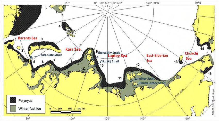
2.1 Physical Characteristics of the Northeast Passage
When navigators are considering which shipping lane to sail through the NEP, the choice is strongly
affected by the natural conditions. One of the primary factors when selecting a favorable shipping
lane on the NSR is the distribution of sea ice. The ice conditions vary greatly between seasons, be-
tween years, and between the marginal seas. A major percentage of the recent NEP commercial
shipping activities do not involve the NSR. Under normal conditions, winter navigation on the eastern
NSR is not beneficial, and commercial operations are restricted to the summer season. Currently, the
only year-round transport on the NSR is the Kara Sea Route, between the Port of Murmansk and the
port of Dudinka.
26
Figure 7: Regions of Winter Fast Ice and Polynyas on the NEP/ NSR
Polynyas: 1 – Cheshskaya, 2 – Pechora, 3- West Novaya Zemlya, 4 – Victoria Sea, 5 – Amderma, 6 – Yamal, 7 – Ob-Yenisey, 8 – West
Severnaya Zemlya, 9 – East Severnaya Zemlya, 10 – Taymyr, 11 – Lena, 12 – New Siberian, 13 – Wrangel, 14 – Alaska, 15 – Anadyr
26
Source: Ragner (2000)
Marine Traffic in the Arctic – Commissioned by the Norwegian Mapping Authority Side 11All other transport is carried out only during summer. The summer season has traditionally been
defined as June-October, but favorable ice conditions and technological improvements have gradual-
ly allowed an extended summer season. Navigation during the winter season (November-May) is
generally much more difficult than in the summer season, due to the thicker ice cover. An important
feature of winter navigation is the fast ice – stable, immovable ice which is fastened to the coastline.
Fast ice is very difficult to pass through, and normally it is preferable to avoid it by using northerly
routes. Nonetheless, if off-shore winds prevail, one will often during winter find open leads at the
edge of the fast ice – so called polynyas, which are very suitable for navigation27
While the ports of Barents Sea is almost completely ice free even in the winter, no parts of
the NSR are completely ice free even during the most favorable summer month (September). Each
end of the NSR – the south-western Kara Sea and the south-western Chukchi Sea – has the lightest
ice conditions, with the East Siberian Sea having clearly the most difficult ice conditions (see figure 7
and 8). This corresponds with navigational experience, where the East Siberian Sea has been seen as
the most difficult sea to navigate, and also being the main bottleneck in terms of navigation. Moreo-
ver, the difficult conditions in the East Siberian Sea has to do with the ice massifs, consisting of mul-
tiyear ice, and which often extends almost to shore even during summer due to currents and winds.
Variations in water depth and narrow straits are other key factors that decide which naviga-
tion course to set on the NSR. Since most of the NSR consists of continental shelves, a major part of
the corridor and especially the straits are shallow. Shoals depth less than 20m are by no means rare
and increases the risk that deep-draft vessels may run aground. However, there are great variations
between the marginal seas of the NEP. Although the western and eastern Barents Sea has depths of
100-300m, the Kara Gate (the main shipping strait between the Barents and Kara seas) is mere 20-
30m deep. Furthermore, the Kara Sea has an average depth of 90m, but some areas, however, are as
shallow as only a few meters. Of key importance to shipping on the NSR is that four straits require
mandatory icebreaker escort, organized by the Russian Authority, Marine Operation Headquarters.
This includes: the Vilkitskii Strait, the Dmitri Laptev Strait, the Shokalskiy Strait and the Sannikov
Strait.
Figure 8: General Locations of Summer Ice Massifs on the NSR
Noted are three types of summer ice massifs: Multiyear ice from the Arctic Ocean (North Kara, Taymyr and Ayonskiy); local drift ice (Novaya
Zemlya and Wrangel); and, fast ice remnants (Severnaya Zemlya, Yanskiy and New Siberian). Source: Ragner (2000)
27
See Appendix A for an overview of various ice types.
Marine Traffic in the Arctic – Commissioned by the Norwegian Mapping Authority Side 12The Vilkitskii Strait is a key NSR Strait between the Kara and Laptev seas. Although it has adequate
water depth for deep draft vessels, it is mainly ice covered, except from a short period in the summer
season. Thus, Shokalskiy Strait is a second possible route north of Vilkitskii Strait. The Laptev Sea has
an average depth of 600m, but as one draws near to the New Siberian Islands the sea becomes shal-
lower than 20m. The route alternatives between the Laptev and the East-Siberian are either through
the Dmitri Laptev Strait or the Sannikov Strait. Both straits have minimum depths of 12-13m, a limit-
ing factor in terms of maximum ship draught on the NSR. Long Strait links the East Siberian and the
Chukchi seas. In this part of the NSR, draught should not be a problem for any ship that keeps well
offshore from the mainland.
2.2 Physical Characteristics of the Northwest Passage
Sea ice conditions on the NWP are very complex. Observations of minimum sea-ice extent in the
eastern and western regions of the NWP, illustrates the extraordinary inter-annual variability of the
ice conditions. Although the trends in sea ice extent are negative in both regions over the period, the
year to year variability is extreme and sometimes differs between the two regions. Although climate
models for the Arctic, like the ACIA models, indicate a general retreat of sea ice throughout the 21
Century, the designated projection models provide no information on ice thickness (a critical factor
for navigation). It is important to note that the horizontal resolution of these models (generally 200
kilometers) is not fine enough to take into account the complexity of the Canadian Archipelago.
Hence there is more uncertainty when it comes to predicting future ice conditions in the NWP based
solely on the output of climate models. 28
There are potentially seven routes through the NWP. All of the routes starts out in the east-
ern part of the Parry Channel heading westward until six of them at different points along the chan-
nel breaks off and take a southerly direction to reach the coastal waters of the mainland before mak-
ing a turn westwards towards the Beaufort Sea. The seventh route employ the Parry Channel in its
entirety until it reaches the Beaufort Sea through the often ice clogged M’Clure Strait between Mel-
ville and Banks Islands. Of the six southerly routes, the most navigable to be employed by interna-
tional shipping comprises the Parry Channel until it takes a southerly direction and goes through the
Prince of Wales Strait between Banks and Victoria islands, and then west again along the north coast
of the Canadian mainland and Alaska to the Bering Strait (see Figure 9).29
Of the potentially seven routes through the Canadian Archipelago, three are considered as being
practical for routine marine traffic and the fourth which is less so (see figure 10). This includes:
M’Clure Strait, This is the shortest and deepest route with no draft restrictions, but the most
difficult way due to the severe ice in the M’Clure Strait (120 kilometers wide at east end, 275
kilometers to the Beaufort Sea and depth at over 400 meters).
Prince of Wales Strait: the passage through the Prince of Wales strait (Minimum width of
less than 10 kilometers about half way through the strait, 230 kilometers long) has an aver-
age depth of 32 meters which tends to be the limiting factor.
Peel Sound: navigation of this route is more challenging and the route is limited to ships hav-
ing a draft of less than 10 meters.
Fury and Hecla Strait: This route has a draft limit of 10 meters.
28
ACIA (2005), p. 924
29
Pharand (1973), pp. 50-54 and Brigham (06), p.138
Marine Traffic in the Arctic – Commissioned by the Norwegian Mapping Authority Side 1330
Figure 9: Seven Possible marine traffic Routes through the NWP
31
Figure 10: Navigation Route Alternatives on the NWP
30
Athropolis Arctic Maps
31
CASA (2007)
Marine Traffic in the Arctic – Commissioned by the Norwegian Mapping Authority Side 143 Marine Traffic Patterns in the Arctic – Three Types of Traffic Con-
cepts
When considering marine traffic patterns in the Arctic, a distinction between three types of traffic
concepts or sailing routes are being addressed:
1) Intra-Arctic routes, i.e. sailing lanes between locations (ports) within the Arctic region. As an
example, shipments between the port of Kirkenes and the port of Murmansk.
2) Destination-Arctic routes, i.e. sailing lanes from locations (ports) inside the Arctic region to
destinations outside of the Arctic region. As an example, shipments from the port of Mur-
mansk to the European markets.
3) Transit routes, i.e. sailing lanes between ports in the Pacific and the Atlantic via the Arctic
Ocean. As an example, shipments between ports in Germany and ports in China via the
Northeast Passage or Northwest Passage.
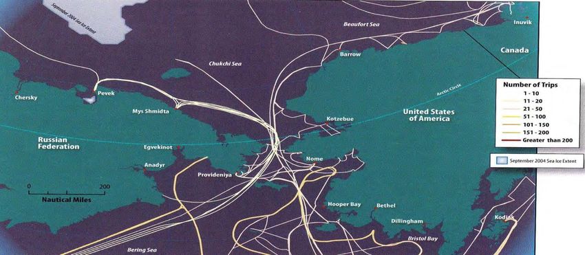
Figure 11: Overview of all vessel activity in Arctic Waters of 2004
Marine Traffic in the Arctic – Commissioned by the Norwegian Mapping Authority Side 15As shown in Figure 11, the most busy ‘Arctic waters’ of vessel activity in 2004 were primarily, accord-
ing to the AMSA, along the Norwegian and Bering Seas - followed by the traffic around Iceland near
the Faroe Islands and southwest Greenland. Fishing vessels were responsible for an important part
of this total. Ships plying these waters also include: bulk cargo carriers, oil tankers, LNG carriers,
coastal ferries, cruise ships and other smaller vessels.
3.1 Current and Expected Marine Traffic on the Northeast Passage
Most recent ship traffic on the NEP includes Intra-Arctic routes and Destination- Arctic routes (See
description above).
Community re-supply represents a significant portion of the Intra-arctic ship traffic between
destinations within the NEP. Furthermore, in areas such as the eastern part of the NEP, this activity is
the basis for most ship traffic. Re-supply activities provide a lifeline to many communities that have
no or very limited road access and no or limited capacity to handle heavy aircraft.
Since 1978 and up to the present, the Russian Icebreaker fleet has succeeded in keeping the
stretch from Murmansk to Dudinka on the banks of the Yenisei River (231 nautical miles from the
river’s mouth) open for sailings 12 months a year. This means that more than 1000 nautical miles, or
some 30 percent of the NEP between Murmansk and the Bering Strait, is now kept open for shipping
all year round. This stretch is what throughout history has been labelled the Kara Sea Route. The
driving force behind this achievement has been the prospects of increased revenues stemming from
year-round shipments of nickel from Igarka. Furthermore, a large percentage of today’s intra-Arctic
and destination-Arctic shipping activity using the NEP, involves transportation through the Barents
Sea. Development of port capacities in the Russian part of the Barents Region is directly connected to
the increase of petroleum exports. In 2008, the ports/terminals of Varandey, Arkhangelsk, Vitino and
Murmansk, directly or through the offshore terminals in the open areas of the Barents Sea, exported
about 10 million tons of crude oil and petroleum products. In 2009, the volume of oil exported to the
western market through the Barents Sea was estimated approximately 15 million tons.
The NSR never got the intended significance as a Transit-Arctic route between the two world
oceans. Transit traffic reached a maximum cargo volume in 1993 with 208,600 tonnes brought in by
30 voyages of multi-purpose ships of the Norilsk type (SA-15).32 In recent years there has been an
increased focus from international ship owners on the possibilities of transit, through the NEP. 2009
was a kind of a test year for vessels sailing through the entire route from Asia to Europe, via the NEP
and 2010 was a breakthrough for commercial shipping along the NEP (See figure 12). So far, by au-
gust 2011, the first supertanker (suezmax class) has made a transit through the NSR. This is the first
time in the history a ship of such dimension (280 m long, 50 m wide and with a draft of 13 m.) has
sailed through the entire NSR.33
32
Peresypkin and Yakovlev (2008). P. 1
33
http://barentsobserver.com/first-supertanker-along-northern-sea-route.4951370-116320.html
Marine Traffic in the Arctic – Commissioned by the Norwegian Mapping Authority Side 16Figure 12: Transit routes along the NEP, 2009 to (August) 2011
Ship owner Name of the Dwt Destinations (Dates) Cargo Comments
ship
Beluga Ship- MV Foresight 12 000 Vladivostok (21.08.09) Heavy lift First foreign ships in
ping Group Novy Port (07.09.09) – modules transit through the NSR
MV Fraternity 12 000
Murmansk Passage
Beluga Ship- MV Houston 12 000 Norrkoping - Heavy lift Not a complete transit.
ping Group Novy Port (26.07.10) modules Only parts of the NSR was
MV Fortitude 20 000 ued
Murmansk Indiga 16 000 Murmansk (14.07.10) - Pevek Diesel fuel First ship to transit the
Shipping Varzuga 16 000 (22.07.10) NSR in 2010
Company
Sovcomflot Baltica 100 000 Murmansk (14.08.10) - Pevek LNG The largest tanker ever to
(25.08.10) - cross the NSR
Ningbo (China) (06.09.10)
Nordic Bulk MV Nordic 41 000 Kirkenes (04.09.10) - Iron ore First foreign bulk ship ever
Carriers Barents China (30.09.10) to cross the NSR
Norilsk Nikkel Monchegorsk 18 000 Murmansk (15.09.10) - Du- Iron ore First ship ever to transit
dinka - he the entire NSR without
Shanghai (17.10.10) icebreaker assistance
Russian state Georg Ots 12 600 Murmansk (09.09.10) - Ana- Passanger First passanger ship ever
owned dyr (26.09.10) - ship to transitt the NSR
Petropavlovsk - Vladivostok
(10.10.10)
Belgian Perseverance 70 000 Murmansk (27.06.11)- China Oil con- Currently, the first and the
Owned (15.07.11) densate only oil shipment in 2011.
STI Heritage STI Heritage 73 000 Murmansk (19.07.11) – Map Gas con- Fastest transit through the
Shipping Co. Ta Put in Thailand (16.08.11) densate NSR with an average
speed of 14 knots. Only 8
days.
Sovcomflot Vladimr Thi- 162 000 Murmansk (20.08.11) - Gas con- First Supertanker (Suez-
konov densate max) through the NSR.
When considering the marine traffic on the NEP during the years ahead, international studies like the
Shipping in Arctic Waters (2010) and the AMSA (2009) argues that the most significant increase of
marine be Destination-Arctic shipping and resource based. However, there are great uncertainties.
Increased shipments of resources form the Norwegian and Russian part of the NEP will be highly
dependent on a sufficient infrastructure. Today, there are some 50 Russian ports on the NEP open to
foreign vessels. Nevertheless, more than half of the ports are out of operation and only a very few
can meet the technical standards required by the international shipping industry. Even if there are
adequate accesses to ice-breaker assistance, only a very few have the essential facilities such as ade-
quate water depth, berths and mechanizations needed for increased shipping. Adequate marine
communication systems exist in some parts of the NEP, but not in others. Communications using
VHF-radio, MF- and HF-systems and satellite are generally adequate for the lower parts of NEP, but
data transmission becomes problematic when the high arctic is reached. Russia has currently several
ongoing projects developing systems to meet the demand of better communications for ships oper-
Marine Traffic in the Arctic – Commissioned by the Norwegian Mapping Authority Side 17ating along the NEP. Several search and rescue centers are located along the NEP, but only a few can
give the support needed for ships sailing along the route.
3.2 Current and Expected Marine Traffic on the Northwest Passage
Current shipping demand in the Eastern part of the Canadian Arctic involves up to 22 seasonal trips
and occurs during the 100 day navigation season that span from mid-July to the end of October
(most communities receive at most two re-supply calls a year). Recently, marine operations averaged
100 voyages by large ships in summer.
Figure 13: The Arctic Bridge ( marked with red color)
Churchill is a prime trading port in the east. In 2004, 14 out of 18 foreign voyages to the Canadian
Arctic called the port of Churchill, shipping wheat and grain to international markets. The first Rus-
sian shipment of fertilizer to the port of Churchill, coupled with perception of an extended sailing
season due to global climate change, has renewed planning for establishing an international “Arctic
Bridge” between Murmansk and Churchill.
In September 1992, the Arctic Bridge Agreement was signed between Canada and Russia.
The major goods that might become the basis for significant trade between the two regions are bulk
commodities, mainly the export of an estimated 315 000 tonnes of mineral products and lumber
from Murmansk, and a minimum of 600 000 tonnes of export grain from Churchill.34 The Bridge goes
through the Barents and Norwegian Seas and proceeds south of Iceland and Greenland before mak-
34
Arctic Bridge (1994)
Marine Traffic in the Arctic – Commissioned by the Norwegian Mapping Authority Side 18ing a northward turn through the Davis Strait to reach Churchill in Hudson Bay. For this bridge to
materialize, Churchill will require significant additional port and rail investments, as well as further
study by both countries regarding costs, cargos and volumes. The port of Murmansk is in need of
similar improvements before this intra-regional traffic scheme – or intra- international route - can be
realized.
In the western part of the Canadian Arctic cargo is handled by tugs and barges, with most
cargo shipped down the Mackenzie River to Tuktoyaktuk for transfer to ships with deeper ocean
drafts. Current shipping demand involves 14-15 seasonal tug-barge trips. These operations take place
in what has been labelled the Mackenzie River route35 – a Canadian intra-Arctic route of some re-
gional significance. The western Arctic sailing season is typically 60 days between mid-July and mid-
September. These are some of the more important destination Arctic shipping locations within the
Canadian Arctic: the port of Churchill, the oil field at Cameron Island, the Nanisivik zinc-lead mine in
the vicinity of Arctic Bay, Tuktoyaktuk, Cambridge Bay, Resolute, Pond Inlet, Inuvik and Whitehorse.
It is anticipated that by 2020, annual re-supply demand will require up to 30 ship trips, and destina-
tion Arctic export shipping will probably include Mary River Iron ore, Port at Steensby Inlet, Roche
Bay magnetite, Igloolik, Grays Bay and Bathurst Inlet.36
In contrast to the NEP/NSR, there are very few ports along the NWP. There are essentially no ade-
quate deepwater ports along the northern slope of Alaska or throughout the NWP. The lack of major
ports and port facilities is also one considerable limiting factor in terms of increased shipping on the
NWP. Furthermore, there are several obstacles related to trans-Arctic shipping in the near future (i.e.
ice conditions, refuge, seasonality, geographical complexity, draft restrictions, choke points, insur-
ance limitations and other costs). However, most Arctic shipping scenarios indicate an increase in the
years ahead, but the shipping will be destination-Arctic and intra-Arctic and mostly resource based.
These expectations are also related to a not significant, but nonetheless increasing Arctic population
and an increasing demand for consumer goods, community construction and industrial shipments.
Based on these expectation it will require significant port improvements.
From a navigational point of view, the NWP will be the last area where the multiyear ice will
disappear and shipping through this Passage will remain risky even in the summer season. The ice
models indicate that the ice conditions will be too heavy for any commercial shipping.
3.3 Cruise Traffic
In the shorter perspective, specialist operators will continue to offer cruises in all three passages.
With powerful icebreakers one can reach the North Pole or circumnavigate the entire Arctic Ocean.
With expedition ships and ice classed passenger/cruise vessels, trips are offered into the NWP and in
the NSR trips go to Novaja Zemlja and Franz Josef’s Land in the west and to the Wrangle Island in the
Chukchi Sea in the east. The vessels are fairly small – 50 to 400 passengers – very small compared to
the largest cruise vessels of more than 5000 passengers. The larger vessels concentrate on the blue
waters around Svalbard and Greenland, which is the target for most Arctic cruises, while the smaller
vessels go on expeditions in ice-covered waters. Arctic cruises are a small niche product, indeed,
compared to the mass-markets of the Caribbean or the Mediterranean. The cruise vessels used in
Arctic operations are very much self-contained units that are not dependent on land infrastructure.
This is fine when everything goes smoothly, but is a major problem the day an accident occurs. The
35
AMSA (2008), p. 79
36
AMSA (2008), pp.148-149
Marine Traffic in the Arctic – Commissioned by the Norwegian Mapping Authority Side 19coastal states face a big challenge when it comes to providing adequate search and rescue service if
cruise activities expand in the Arctic.
Complete data for all Arctic cruises are hard to obtain, but some indications of the develop-
ment in later years can be found in data from Greenland and Svalbard.
Figure 14 shows the development of cruise ship activities in the ports of Greenland. The
number of arrivals of cruise ships in Greenland ports has increased by an average of 48,9 % per year
from 2005 to 2008.
Figure 14: Cruise ship arrivals in Greenland ports and harbors 2003-08
Another indication of an increased interest for sailings in the high north is data from Longyearbyen.
Figure 15 shows the number of ship calls, while Figure 16 shows the number of cruise passengers
arriving in the port. The average growth rate 2001-2008 of passengers arriving is 14% per year.
37
Figure 15: No. of ship calls in Longyearbyen 2001-2008
37
Source: St.meld (White Paper) 22, 2008-09, section 10.4.1
Marine Traffic in the Arctic – Commissioned by the Norwegian Mapping Authority Side 2038 Figure 16: No of Cruise Passenger arriving Longyearbyen 1999-2008 There is a need for further assessments in order to find the number of passengers that go on Arctic cruises. AMSA refers to an independent survey indicating that in 2004, 1.2 mill passengers went on an Arctic cruise and that this number more than doubled in 200739. This implies that more than 15 per cent of all cruise passengers had an Arctic destination, since the world total number of cruisers is estimated at around 15 million. Such a number seems much too high, even if ferry passengers are included. Hurtigruten40 has 11 ships on daily trips to the north, but in total they carry a little over 100.000 passengers per year, which would be less than 0.5 per cent of all Arctic cruises if this study is to be trusted. 38 St.meld (White Paper) 22, 2008-09, section 10.4.1 39 AMSA, 2009, p 79. No source is given for the mentioned independent survey 40 A Norwegian passenger and freight line with sailings along the Norwegian western and northern coast. Marine Traffic in the Arctic – Commissioned by the Norwegian Mapping Authority Side 21
4 Recommendations
In order to get an extensive overview of the transportation passages of the Arctic and the expected
transport patterns further in depth studies is needed. Our recommendations are as follows:
Assess the transport infrastructure (the availability, state of the art and challenges), in order
to support efficient ship transportation along the Arctic sea routes.
Evaluate the current status of ports and port facilities along the Arctic transportation passag-
es.
Asses the search and rescue availability on the Arctic sea routes, in order to support com-
mercial shipping
Examine the current status of satellite systems and radio communication on the Arctic sea
routes, in order to make an assessment of the safety level of marine transportation.
Examine the Arctic ice-breaker fleet (Russia, Canada, Norway, US etc.) in order to get an
overview of the current availability and the challenges to support increased marine traffic.
Assess the legal regime of shipping in the Arctic, in order to get an overview of the require-
ments of transportation in the Arctic.
An examination of the resource activities in the Arctic, exploration and exploitation, in order
to get a more extensive overview of the expected marine traffic patterns.
A case study of the marine Cruise traffic throughout the Arctic; classifying which routes that
is most frequent used etc.
Marine Traffic in the Arctic – Commissioned by the Norwegian Mapping Authority Side 22Appendix A:
The diversity of sea ice varies in shapes, thicknesses, ages and hardness, presenting different chal-
lenges to navigation. These are some of the more frequent: 41
New Ice: Recently formed ice composed of ice crystals that are only weakly frozen together
(if at all) and have a definite form only while they are afloat.
Nilas: A thin elastic crust of ice (up to 10 cm in thickness), easily bending on waves and swell
and under pressure growing in a pattern of interlocking "fingers" (finger rafting).
Young Ice: Sea ice in the transition stage between nilas and first-year ice and 10-30 cm in
thickness.
First-Year Ice: Sea ice of not more than one winter's growth, developing from young ice hav-
ing a thickness of 30 cm or more.
Old Ice/multi-year ice: Sea ice that has survived at least one summer's melt. Its topographic
features generally are smoother than first-year ice and can be a few metres thick. Old ice is
also much harder than first year ice, and can be much more damaging to ships, if hit at a
normal cruise speed.
Ice Massifs: are manifested as extensive accumulations of close or very close ice that are
found in the same region every summer.42
Drift ice: is ice that floats on the surface of the water in cold regions, as opposed to fast ice,
which is attached "fastened" to a shore. Usually drift ice is carried along by winds and sea
currents, hence its name, "drift ice".43
Pack ice: When the drift ice is driven together into a large single mass, it is called pack ice.
Wind and currents can pile up ice to form ridges three to four meters high, creating obstacles
difficult for powerful icebreakers to penetrate. Typically areas of pack ice are identified by
high percentage of surface coverage by ice: e.g., 80-100%.44
Ice floe: is a large piece of drift ice that might range from tens of meters to several kilometers
in diameter. Wider chunks of ice are called ice fields.45
41
Definitions derived from: http://ice.ec.gc.ca/WsvPageDsp.cfm?ID=181&Lang=eng
42
Johannessen, (2007), p.257
43
Description taken from: http://en.wikipedia.org/wiki/Drift_ice
44
Description taken from: http://en.wikipedia.org/wiki/Drift_ice
45
Description taken from: http://en.wikipedia.org/wiki/Drift_ice
Marine Traffic in the Arctic – Commissioned by the Norwegian Mapping Authority Side 23You can also read