SIMULATION NUMERIQUE DU TSUNAMI GENERE PAR UN EBOULEMENT DU FLANC DU VOLCAN CUMBRE VIEJA (LA PALMA, CANARIES), PAR UNE APPROCHE COUPLEE ...
←
→
Page content transcription
If your browser does not render page correctly, please read the page content below
SIMULATION NUMERIQUE DU TSUNAMI GENERE PAR
  UN EBOULEMENT DU FLANC DU VOLCAN CUMBRE
  VIEJA (LA PALMA, CANARIES), PAR UNE APPROCHE
       COUPLEE NAVIER-STOKES / BOUSSINESQ

     NUMERICAL SIMULATION OF THE TSUNAMI
     GENERATED BY THE CUMBRE VIEJA FLANK
   COLLAPSE (LA PALMA, CANARY) BY A COUPLED
     NAVIER-STOKES / BOUSSINESQ APPROACH

                      J.C. HARRIS∗,∗∗ , S.T. GRILLI∗∗ , S. ABADIE∗∗∗

  * Now at Laboratoire Saint-Venant, Ecole des Ponts, 78401 CHATOU, jcharris@oce.uri.edu
  ** Department of Ocean Engineering, Univ. of Rhode Island, Narragansett, RI 02882, USA
  *** SAIME EA 4581, Université de Pau et des Pats de l’Adour, 64600 ANGLET

                                          Résumé

     Plusieures études antérieures indiquent que l’éboulement à grande échelle du flanc du
volcan Cumbre Vieja (CVV) sur l’ı̂le de La Palma (Iles Canaries) générerait un méga-
tsunami qui pourrait potentiellement dévaster de nombreuses zones côtières de l’Atlan-
tique nord. Dans ce travail, on présente une série de scénarios de tsunamis potentiels,
sur la base d’études préalables de la stabilité des pentes du volcan, du mouvement de
l’éboulement généré, et des vagues produites dans le champ proche [4]. Lors des simu-
lations numériques, le modèle Navier-Stokes THETIS est utilisé pour la modélisation de
l’éboulement et des vagues qu’il génère et le modèle Boussinesq FUNWAVE-TVD pour la
modélisation de la propagation du tsunami, sous la forme d’un train d’ondes dispersives,
dans une série de maillages emboités de résolution adéquate, pour le champ proche, la
propagation dans l’océan Atlantique et le champ lointain. Dans ce travail, on présente de
nouveaux résultats à haute résolution (1 min. d’arc) pour la propagation transocéanique,
de même que le couplage unidirectionnel vers des maillages côtiers plus fins, pour la
prévision de l’inondation et du runup dans les zones vulnérables. Les résultats sur des
maillages de 4 sec. d’arc en zones côtières confirment la précision du schéma de couplage
qui a été implémenté dans FUNWAVE-TVD.

                                         Summary

    Several earlier studies indicate that the large scale flank collapse of the Cumbre Vieja
Volcano (CVV) on La Palma (Canary Islands) could generate a mega-tsunami, potentially
devastating for many of the coastal areas of the North Atlantic Ocean. A detailed study
of potential tsunami scenarios is presented herein, based on earlier studies of the volcanic

                                              1
slope stability, generated landslide motion, and near-field wave motion [4]. In numerical
simulations the Navier-Stokes model THETIS is used to model the landslide motion and
resulting wave generation, and the Boussinesq model FUNWAVE-TVD to model the
dispersive tsunami wave propagation in a variety of nested grids of adequate resolution, in
the near-field, across the Atlantic Ocean, and in the far-field. In this paper, we present new
results of transoceanic propagation at high resolution (1 arc-minute) as well as one-way
coupling to finer coastal grids, for the prediction of inundation and runup in vulnerable
areas. Coastal results in 4 arc-second resolution grids demonstrate the accuracy of the
one-way coupling scheme that has been implemented in FUNWAVE-TVD.

   I – Introduction
    Recent catastrophic events (e.g., 2004 Indian Ocean, 2011 Tohoku) have dramatically
demonstrated the risk faced by coastal communities due to tsunamis. While not as tsunami
prone as other oceanic basins, one potential source of a major tsunami in the Atlantic
Ocean is an extreme collapse of the western flank of the Cumbre Vieja Volcano (CVV ;
if destabilized, e.g., due to a local earthquake/volcanic eruption), as suggested by Ward
and Day [41] in their pioneering work. They considered a large 500 km3 slide and, using
simple models, predicted the generation of waves as large as 10-20 m off of the US east
coast. Both the landslide parameters and model, and wave modeling, have since then been
criticized and revisited by a number of authors [31, 34], but while more advanced models
of the landslide generation [3] show smaller waves forming than originally suggested, these
are still extremely large and hence the potential for a far-field coastal hazard could still
exist and ought to be assessed.
    Large landslides are in fact inherent to the volcanic building process, as material
continuously accumulates until the point of slope failure [20]. Even small debris flows
like the 0.5 km3 Shimabara flank collapse in 1792 killed at least 4,000 people [21], and
two consecutive landslides of O(1 km3 ) (first underwater and second subaerial) during
the Stomboli eruption of 2002 produced local runup of 10 m [40]. There is also clear
geological evidence of past large paleo-submarine landslides of O(100 km3 ) volume around
the Canary Islands (Spain). Masson et al. [32] identified at least 14 large landslides, with
the youngest one, at El Hierro, being only 15,000 years old. Such potentially catastrophic
events may occur in average every 100,000 years in the Canary Archipelago. However, low
probability does not necessarily mean low risk ; so for proper tsunami hazard assessment,
the consequences associated with such catastrophic events must be carefully estimated
and modeled.
    The results below build upon our earlier results [3, 4, 18], which considered the land-
slide generation, near-field impact, and the amplitude of the waves within the Atlantic
Ocean at a medium grid resolution. To pursue such simulations, we must make use of
several different models and grids (Fig. 1). Here, we first perform higher resolution mo-
deling of the propagation phase in the Atlantic (i.e., 1 arc-minute resolution instead of 2
arc-minute resolution of [18]), and also present some preliminary high-resolution (4 arc-
second) results for a small coastal region of a distant coast (Myrtle Beach, USA), obtained
by way of a new one-way coupling procedure.

                                              2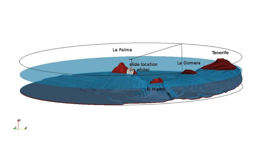
400
                                                                                                                                     3000
                                                          300     FUNWAVE TVD domain
                                                                                                                                     2000
                                                          200
                                                                                                                                     1000
                                                                                              THETIS domain
                                                          100
                                                                                                                  Lanzarote
                                                                                                                                     0
                                                                                   La Palma

                                                 y [km]
                                                                                                Tenerife
                                                           0                                                   Fuerteventura             1000

                                                          100                      Gomera       Gran Canaria                             2000
                                                                          Hierro

                                                          200                                                                            3000

                                                          300                                                                            4000

                                                          400                                                                            5000
                                                            400   200          0                  200          400             600
                                                                                       x [km]

                      (a)                                                                     (b)

                      (c)                                                                     (d)
Figure 1 – Computational domains used for modeling the potential CVV events, in-
cluding : (a) the higher resolution 3D THETIS domain surronding La Palma ; (b) the
500 m resolution FUNWAVE-TVD near-field domain ; (c) the 1 arc-minute resolution
FUNWAVE-TVD Atlantic basin domain ; and (d) the 4 arc-second resolution FUNWAVE-
TVD fine resolution coastal domain, to demonstrate coastal impact in the US (Myrtle
Beach, SC). Red boxes in grid (c) indicate the boundary of grids (b) and (d).

   II – Models
   II – 1    THETIS
    THETIS is a three-dimensional general purpose multi-fluid NS solver, developed over
the past 15 years by the TREFLE CNRS laboratory at the University of Bordeaux, France.
THETIS has been used to model wave generation from rigid or deforming slides [33, 5],
but also is accurate to simulate plunging breaking waves [1, 30], which is important for
accurately simulating initial waves due to violent subaerial slides. In THETIS, the air-
water-slide domain is modeled as a single fluid, but one whose density and viscosity vary
with space (using a penalty method). For this case, the incompressible NS equations are
solved using a large-eddy simulation, where the water, air, and slide are represented as a
single Newtonian fluid (though the model could easily use non-Newtonian laws to simu-
late the slide, such as the Herschel-Bulkley generalized model). In the present application,

                                             3
turbulent dissipation is modeled using a mixed scale subgrid model [30]. The governing
equations are discretized using the finite volume method on a fixed staggered grid. All
fluid-fluid interfaces are tracked using the VOF method [19]. Details of the model, inclu-
ding validation for slide generated waves, are given by Abadie et al. [5].
A cylindrical mesh surrounding La Palma (Fig. 1) was used for these simulations, where
the grid size grows with distance from the domain center, and the islands of El Hierro, La
Gomera, and Tenerife have been included in the domain. The domain extends 8 km from
top to bottom, and has a 150 km radius, with 80 grid cells vertically (stretched ; minimum
spacing 10 m), 300 cells radially, and 140 cells in the tangential direction (stretched ;
minimum spacing 1.4o ).
Based on earlier slope stability analyses [2, 10], four scenarios were considered : 40 and
80 km3 slide volume scenarios considered consistent with the stability analysis, and two
extreme cases, with 20 and 450 km3 , the latter being similar to that used by many authors
when accounting for the more accurate geometry of the volcano represented here [41, 35,
12, 11, 29]. In this paper, we will consider the two largest slide volumes (i.e., a most-likely
and a worst-case scenarios). For these cases, the debris flow is modeled as a constant 2,500
kg/m3 density (corresponding to basalt). Basal friction is not specified, nor resistance to
internal deformation, both of which would likely reduce the magnitude of the resulting
tsunami. Results suggest that these factors are small in large rock slides, however [28].
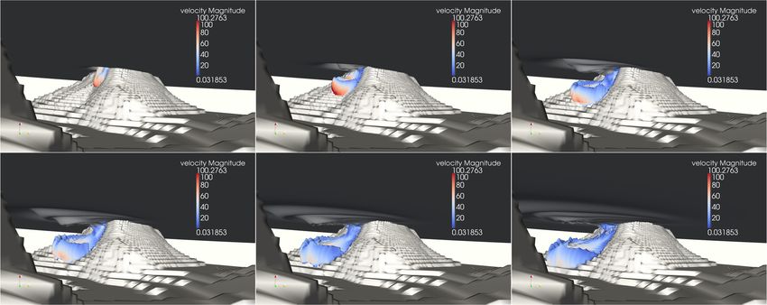
Figure 2 – Simulations of landslide tsunami generation with THETIS, for an initial slide
volume of 80 km3 . Underwater views of water and slide interfaces (volume fractions res-
pectively equal to 0.5 and 0.1) at t = a) 50 s, b) 100 s, c) 150 s, d) 200 s, e) 250 s, and f)
300 s.
Figure 2 shows results of THETIS simulations for the 80 km3 CVV flank collapse sce-
nario, consisting in six underwater snapshots for increasing time, displaying the air/water
and water/slide interfaces. The 0.5 water volume fraction defines the air-water interface,
while the 0.1 slide volume fraction defines the water/slide interface. [Note, the latter value
was selected rather than 0.5 because, due to the combined effects of mixing and shearing,
a 50% slide volume rate no longer occurs beyond some stage of slide motion.] The cou-
pling between slide motion and free surface wave generation is quite clear on the figure,
with first the generation of a large depression wave associated with the strong initial slide
downward velocity, characteristic of large subaerial slides, and then the propagation of a
train of cylindrical waves radiating away from the slide. Simulations indicate that, for a
4long time, the slide nearly travels at the speed of the leading generated surface wave, allo-
wing for a large transfer of its energy to waves. Tsunami directivity is approximately 24o
from west. As shown in Abadie et al. [4], the resulting waves are of intermediate depth, so
frequency dispersion is important. Thus, a dispersive model must be used to simulate the
transoceanic propagation and simulate waves in the far-field, as opposed to the traditional
nonlinear shallow water equations usually used for co-seismic tsunami modeling.
II – 2 FUNWAVE-TVD
As a Navier-Stokes model would be too computationally costly and dissipative to
use for simulating distant wave propagation, beyond the region directly surrounding La
Palma, a 2D Boussinesq model FUNWAVE-TVD is used, which is initialized with the
3D THETIS model results. FUNWAVE-TVD is a recent improvement of the FUNWAVE
model [43, 24, 7, 8, 25], which was originally developed and used for simulating coas-
tal and nearshore waves, but was later successfully applied to a variety of tsunami case
studies, both landslide and co-seismic [42, 9, 17, 22, 38, 23, 13]. FUNWAVE-TVD was
developed as a fully nonlinear and dispersive model, first in Cartesian coordinates [36],
and later in spherical coordinates with Coriolis effects [26, 27] approximation ; although
formulated for full nonlinearity as well, the latter model has only been implemented so far
as a weakly nonlinear approximation. Hence, since initial waves generated by the CVV
slide and modeled in THETIS are strongly nonlinear, the Cartesian fully nonlinear model
is first used for the simulations in the near-field coastal grids. Then, the weakly nonlinear
spherical model is used for simulating the transoceanic propagation in the Atlantic Ocean
basin scale grid (Fig. 1). FInally, for the nearshore coastal grids, along the US east coast,
as nonlinearity becomes significant in shoaling waves, the fully nonlinear Cartesian mo-
del should again be used. However, at present, to more easily demonstrate our one-way
coupling scheme, the spherical version is also used in a far-field 4 arc-second coastal grid.
In the future, however, the Cartesian version will be used instead. It should be noted, the
same Boussinesq models were successfully used to predict both far-field propagation [14]
and coastal impact [16] of the recent 2011 Tohoku earthquake (see Grilli et al.’s paper in
these proceedings).
While co-seismic tsunami propagation has traditionally been done using the nonli-
near shallow water equations, tsunamigenic landslides such as in the present case produce
shorter, dispersive wave trains and hence require non-hydrostatic or Boussinesq-type mo-
dels for their accurate modeling. FUNWAVE-TVD is based on the equations of [6] and
[36], which use a combined finite-volume and finite-difference MUSCL-TVD scheme. As
in FUNWAVE [43], improved linear dispersive properties are achieved, up to the deep
water limit, by expressing the BM equations in terms of the horizontal velocity vector at
0.531 times the local depth. FUNWAVE-TVD’s latest implementation is fully parallelized
using MPI, for efficient use on distributed memory clusters. This model was fully vali-
dated using all of NOAA’s National Tsunami Mitigation Program (NTHMP) mandatory
benchmarks in both Cartesian [39] and spherical [37] coordinates.
III – Coupling
The modeling of wave propagation for such a large range of scales, from landslide ge-
neration, deep water oceanic propagation, to inundation on a distant coast, requires using
model grids a various resolution and geometry and hence a coupling scheme to accurately
pass simulation results in real time from one model grid to another was developed.
5III – 1 THETIS to FUNWAVE-TVD
Figure 3 – Test of model coupling for the 80 km3 case, when modeling wave propagation
from t = 300 to 500 s, using : (i) FUNWAVE without filtering of the initial conditions ;
(ii) THETIS ; and (iii) FUNWAVE with filtering of the initial conditions.
In order to transition from THETIS to FUNWAVE-TVD, the 3D-VOF-NS solution
at t = 300 s is used as an initial condition for FUNWAVE. This time is selected as the
leading edge of the tsunami has not yet reached the edge of the THETIS domain, and
although there is still turbulent flow in the 3D domain, results show that all of the energy
transfer from the slide to the tsunami waves has already occurred [3]. The NS velocity
field is depth-averaged and the averaged horizontal velocity, together with the free surface
elevation are interpolated onto the FUNWAVE mesh (which satisfies has conservation).
This results in a slight error (2nd-order in kh), as the BM equations are framed in terms of
a single horizontal velocity at a reference depth, but we verified this has little effect on the
results and has the advantage of averaging out the turbulent flow in the vertical direction.
In addition, the NS solution is further filtered near the slide motion prior to using it in
FUNWAVE [3]. An ad hoc filtering method (Fig. 3) was determined through numerical
experimentation, which consisted in multiplying the output of THETIS (i.e., free-surface
elevation and each velocity component) by a spatially varying function, removing the
interior flow while keeping a smooth initial condition for FUNWAVE. This function is
Gaussian, with a standard deviation of 15 km and the origin located at coordinates (-10
km, -10 km).
6Prior to performing longer-term propagation simulations in FUNWAVE, the authors
verified that this coupling approach provided reasonable initial results, for at least the first
few leading waves, since most of the near-field run-up and inundation will be caused by
these waves, and, in the far-field, by waves originated from these waves through frequency
dispersion. This was done by initializing FUNWAVE using THETIS results at t = 300 s
and performing simulations with both models for an additional 250 s. To assess the ef-
fects of filtering THETIS results, FUNWAVE computations were performed using both
unfiltered and filtered results. Free surface elevations computed in both models were then
compared at t = 550 s. Fig. 3 shows results for the 80 km3 case. Although FUNWAVE’s
unfiltered results appear reasonable as compared to THETIS’, as expected, there is not
enough near-shore dissipation of shorter waves, which stay in the back of the FUNWAVE
train, but do not persist in THETIS results. Besides causing unrealistically large short
waves to appear near La Palma, using unfiltered results also affects at least the 3rd lea-
ding wave in the tsunami train. This is greatly improved in FUNWAVE’s filtered results,
which compare well to THETIS’ ; both the large short waves near La Palma dissipate and
the 3rd leading wave now agrees well with THETIS results. Similar results are seen for
the other slide volumes.
III – 2 FUNWAVE-TVD : fine grid to coarse grid
For moving from a small, fine grid (e.g., to model the source area) to a coarse grid
(e.g., for transoceanic propagation), results are simply interpolated in space – i.e., at a set
time, the results from the fine grid are interpolated to the larger grid, which includes the
wave elevation and horizontal velocity in both the north/south and east/west directions,
as a “hot-start” initial condition.
In order to prevent aliasing effects from changing resolution, the results on the finer
grid are first filtered with a box filter with a filter width equal to that of the coarse grid.
III – 3 FUNWAVE-TVD : coarse grid to fine grid
For dynamically moving from a coarse grid to a finer grid, a one-way coupling scheme
was developed. Boundary conditions are used in the form of time series computed in the
coarse grid for a series of “numerical wave gages” corresponding to the cells of the outer
boundary of the fine grid. We usually start simulating in the fine grid early enough in
time, such that the domain is initially at rest (i.e., the incoming tsunami is barely reaching
its outer boundary). Specifically, here, in the coarser 1’ grid over the ocean basin (e.g.,
Fig. 1c), a series of numerical wave gauges are setup, where time series of water elevation
and velocity are computed along the boundaries of the 4” fine grid off of Myrtle Beach.
These results are linearly interpolated in space and time to provide the boundary values
for the finer grid.
We can test that the results are accurate by comparing the results between the two
grids for the same times (Fig. 4), when waves are still fairly offshore (and hence not too
affected by the nearshore bathymetry) in this case at 9h20’ after the CVV event. Following
transoceanic propagation, the finer grid simulations were initiated at 8h20’ after the start
of the CVV event (hence one additional hour of propagation has already taken place in the
fine grid). We see that the wave amplitude wavelength, direction, all are approximately
the same in both coarse and fine grids, although there is already some wave steepening in
the finer grid as a result of the more finely resolved bathymetry and grid. From this and
similar comparisons, we see that this one-way coupling scheme provides the correct wave
7information to the finer domain.
(a) (b)
Figure 4 – Comparison of wave elevation at 9h20’ after the start of the CVV event
(including 5’ of THETIS and 15’ of 500 m resolution FUNWAVE-TVD modeling) as
predicted for the (a) coarse, 1 arc-minute resolution domain, and the (b) finer, 4 arc-
second resolution domain.
IV – Distant effects
IV – 1 Transatlantic propagation
(a) (b)
Figure 5 – Maximum surface elevation in meters for the 1 arc-minute resolution Atlantic
grid, for both the (a) 80 km3 and (b) 450 km3 CVV slide scenarios. [Note that the high
elevations in the Caribbean are from non-physical numerical instabilities at the wetting-
drying boundary due to low resolution.]
After modeling the initial slide in THETIS for 5 min., and on the regional (500 m)
grid with FUNWAVE for an additional 15 min., the leading wave train is sufficiently long
8to be accurately resolved on a coarser 1 arc-minute grid that covers the North Atlantic
(Fig. 5), from 10o to 50o N, and from 85o to 5o W. The bathymetry for this domain is
taken from ETOPO1. The simulation of the propagation with FUNWAVE shows that
large waves, several meters high, would reach shorelines of the US, Europe and Africa
(in the latter case, waves would be much larger owing to proximity). Figure 5 shows the
maximum wave elevation in the Atlantic computed for both the 80 and 450 km3 CVV
slide scenarios. Clearly either tsunami would have damaging effects for large low-lying
coastal areas and cities all along the Atlantic basin, including northwest Africa, western
Europe, and eastern North America. [Note, the high waves seen in the Caribbean result
from a numerical instability at the wetting-drying interface due to the low resolution, but
does not affect the results elsewhere.]
IV – 2 Far-field coastal impact
(a) (b)
(c) (d)
Figure 6 – Comparison of maximum surface elevation predicted at Myrtle Beach, SC, for
the 80 and 450 km3 CVV slide scenarios, on the 1’ grid (a ; b), and on the 4” grid (c ; d).
Accurately predicting tsunami coastal impact is only possible with high-resolution
modeling of the various nearshore wave transformations, breaking and dissipation that
9take place. This would be computationally prohibitive while simultaneously modeling an
ocean basin with a structured grid (i.e., same resolution everywhere). Instead, nested
grids of decreasing resolution are used as detailed before. Unlike earlier work [18], here
we make use of a recently developed one-way coupling scheme, through applying time-
varying boundary conditions, as described above. Previous work simply used an initial
condition, so the nearshore domains had to extend out far into the ocean to capture the
leading tsunami waves of the tsunami arriving from the coarser grid in the simulation.
Here we consider a 4 arc-second grid from 33.25o to 33.95o N and from 79.2 to 78.4o W,
corresponding to the domain of the Myrtle Beach tsunami DEM (digital elevation model)
to be used for predicting tsunami inundation in the region. The bathymetry used is from
the 3 arc-second resolution NOAA Coastal Relief Model, though for future modeling
higher-resolution data is available for the region. [Note, a rule of thumb of gradually
reducing the grid mesh by a factor of 4 was developed in our earlier work, which we
violate here, for the purpose of illustration, by nesting to a fine grid with a factor of 15 in
mesh reduction.] Figure 6 shows a comparison of the 1 arc-minute and 4 arc-second results
for the 80 and 450 km3 CVV slide scenarios, demonstrating that the general pattern of
results is similar for the two resolutions, but as could be expected the amplitude of the
waves along the coastline is higher in the finer resolution grid results, a sign that the
1 arc-minute grid is too coarse to accurately capture the coastal bathymetry and wave
processes.
Note that the wave elevation decreases as it approaches the shoreline, which is unu-
sual. While along shallow continental shelves in other situations this anomalous dissipation
could be due to the appearance of a breaking bore, where the simple breaking model of
FUNWAVE-TVD may not provide accurate results [15], here there is no sign of such
breaking. It could, however, be caused by the extremely large aspect ratio (1 :15) between
grid spacing and water depth that is used in these simulations, causing unwanted nume-
rical diffusion. More careful nesting of model grids will be used in future work, using in
particular additional intermediate levels of grid nesting.
V – Conclusions
Two scenarios of the potential Cumbre Vieja Volcano (CVV) flank collapse were si-
mulated, including the landslide tsunami generation, propagation, and far-field impact.
THETIS, a multi-fluid Navier-Stokes 3D solver with VOF interface tracking, was first
used to calculate the free surface and water velocity generated by the deforming slide mo-
tion resulting form the CVV flank collapse. Then, FUNWAVE-TVD, a Boussinesq wave
model, was used in a series of nested grids to compute the oceanic propagation and far-
field impact of the potential tsunami along the US East Coast. A new accurate one-way
compiling scheme between model grids was developed and validated in the process.
This work extends our earlier work by considering higher resolution grids and more
efficient one-way coupling of different model grids. It is part of current work being per-
formed for the NOAA-NTHMP program, to develop tsunami inundation maps for the
vulnerable areas of the US East coast, due to all the potential far-field and near-field
tsunami sources.
Future model improvements will consider potential problems that arise from using
different grid resolutions that may artificially affect the dissipation rate nearshore.
10Références
[1] S. Abadie, J. P. Caltagirone, and P. Watremez. Splash-up generation in a plunging
breaker. Comptes Rendus de l’Academie des Sciences Series IIB, 326 :553–559, 1998.
[2] S. Abadie, C. Gandon, S. Grilli, R. Fabre, J. Riss, E. Tric, D. Morichon, and S. Glo-
ckner. 3D numerical simulations of waves generated by subaerial mass failures. Appli-
caiton to La Palma case. In Proceedings of the 31st International Coastal Engineering
Conference, 2008.
[3] S. Abadie, J. Harris, and S. Grilli. Numerical simulation of tsunami generation by
the potential flank collapse of the Cumbre Vieja volcano. In Proceedings of the 21st
Offshore and Polar Engineering Conference, 2011.
[4] S. Abadie, J. Harris, S. Grilli, and R. Fabre. Numerical modeling of tsunami waves
generated by the flank collapse of the Cumbre Vieja Volcano (La Palma, Canary
Islands) : tsunami source and near field effects. Journal of Geophysical Research,
117 :C05030, 2012.
[5] S. Abadie, D. Morichon, S. Grilli, and S. Glockner. Numerical simulation of waves
generated by landslides using a multiple-fluid Navier-Stokes model. Coastal Enginee-
ring, 57 :779–794, 2010.
[6] Q. Chen. Fully nonlinear Boussinesq-type equations for waves and currents over
porous beds. Journal of Engineering Mechanics, 132 :220–230, 2006.
[7] Q. Chen, J. T. Kirby, R. A. Dalrymple, A. B. Kennedy, and A. Chawla. Boussinesq
modeling of wave transformation, breaking, and runup. II : 2-D. Journal of Waterway,
Port, Coastal, and Ocean Engineering, 126 :48–56, 2000.
[8] Q. Chen, J. T. Kirby, R. A. Dalrymple, F. Shi, and E. B. Thornton. Boussinesq
modeling of longshore currents. Journal of Geophysical Research, 108 :3362, 2003.
[9] S. J. Days, P. Watts, S. T. Grilli, and J. T. Kirby. Mechanical models of the 1975
Kalapana, Hawaii earthquake and tsunami. Marine Geology, 215 :59–92, 2005.
[10] R. Fabre, J. Riss, E. Tric, T. Lebourg, and S. Abadie. Potential collapse of the
Cumbre Vieja volcanic edifice (La Palma Island, Spain) : numerical investigation of
the failure model and potential volume. Engineering Geology, (submitted), 2011.
[11] G. Gisler, R. Weaver, and M. Gittings. SAGE calculations of the tsunami threat
from La Palma. Science of Tsunami Hazards, 24 :288–301, 2006.
[12] S. T. Grilli, C. D. P. Baxter, S. Maretzki, Y. Perignon, and D. Gemme. Numerical
simulation of tsunami hazard maps for the US East Coast. Report of Year 1 project.
FMGlobal Project. Technical report, University of Rhode Island, 2006.
[13] S. T. Grilli, S. Dubosq, N. Pophet, Y. Perignon, J. T. Kirby, and F. Shi. Numerical
simulation and first-order hazard analysis of large co-seismic tsunamis generated in
the Puerto Rico thrench : near-field impact on the North shore of Puerto Rico and
far-filed impact on the US East Coast. Natural Hazards and Earth System Sciences,
10 :2109–2125, 2010.
[14] S. T. Grilli, J. C. Harris, T. T. Bakhsh, T. L. Masterlark, C. Kyriakopolos, J. T.
Kirby, and F. Shi. Numerical simulation of the 2011 Tohoku tsunami based on a new
transient FEM co-seismic source : comparison to far- and near-field observations.
Pure and Applied Geophysics, (published online) :27 pp., 2012.
[15] S. T. Grilli, J. C. Harris, F. Shi, J. T. Kirby, T. S. T. Bakhsh, E. Estibals, and
B. Tehranirad. Numerical modeling of coastal tsunami dissipation and impact. In
Proceedings of the 33rd International Coastal Engineering Conference, 2012.
11[16] S. T. Grilli, J. C. Harris, D. Tappin, T. L. Masterlark, J. T. Kirby, F. Shi, and G. Ma.
A multi-source origin for the Tohoku-oki 2011 tsunami earthquake and seabed failure.
Nature Communications, (submitted), 2012.
[17] S. T. Grilli, M. Ioualalen, J. Asavanant, F. Shi, J. Kirby, and P. Watts. Source
constraints and model simulation of the December 26, 2004 Indian Ocean tsunami.
Journal of Waterway, Port, Coastal, and Ocean Engineering, 33 :414–428, 2007.
[18] J. C. Harris, S. T. grilli, S. Abadie, and T. T. Bakhsh. Near- and far-field tsunami
hazard from the potential flank collapse of the Cumbre Vieja Volcano. In Proceedings
of the 22nd Offshore and Polar Engineering Conference, 2012.
[19] C. W. Hirt and B. D. Nichols. Volume of fluid (VOF) method for the dynamics of
free boundaries. Journal of Computational Physics, 39 :201–225, 1981.
[20] R. T. Holcomb and R. C. Searle. Large landslides from oceanic volcanoes. Marine
Geotechnology, 10 :19–32, 1991.
[21] K. Inoue. Shimabara-Shigatusaku Earthquake and topographic changes by Shima-
bara Catastrophe in 1792. Geographical Reports of Tokyo Metropolitan University,
35 :59–69, 2000.
[22] M. Ioualalen, J. Asavanant, N. Kaewbanjak, S. T. Grilli, J. T. Kirby, and P. Watts.
Modeling the 26th December 2004 Indian Ocean tsunami : Case study of impact in
Thailand. Journal of Geophysical Research, 112 :C07024, 2007.
[23] J. M. Karlsson, A. Skelton, M. Sanden, M. Ioualalen, N. Kaewbanjak, N. Pophet,
J. Asavanant, and A. von Matern. Reconstructions of the coastal impact of the
2004 Indian Ocean tsunami in the Khao Lak area, Thailand. Journal of Geophysical
Research, 114 :C10023, 2009.
[24] A. B. Kennedy, Q. Chen, J. T. Kirby, and R. A. Dalrymple. Boussinesq modeling
of wave transformation, breaking, and runup. I : 1D. Journal of Waterway, Port,
Coastal, and Ocean Engineering, 126 :39–47, 2000.
[25] J. T. Kirby. Advances in Coastal Modeling, chapter Boussinesq models and applica-
tions to nearshore wave propagation, surf zone processes and wave-induced currents,
pages 1–41. Elsevier, 2003.
[26] J. T. Kirby, N. Pophet, F. Shi, and S. T. Grilli. Basin scale tsunami propagation mo-
deling using Boussinesq models : Parallel implementation in spherical coordinates. In
Proceedings of the WCCE-ECCE-TCCE Joint Conference on Earthquake and Tsu-
nami, volume paper 100, page (published on CD), 2009.
[27] J. T. Kirby, F. Shi, J. C. Harris, and S. T. Grilli. Sensitivity analysis of trans-
oceanic tsunami propagation to dispersive and Coriolis effects. Ocean Modelling,
(accepted) :42 pp., 2012.
[28] F. Legros. The mobility of long-runout landslides. Engineering Geology, 63 :301–331,
2002.
[29] F. Løvholt, G. Pedersen, and G. Gisler. Oceanic propagation of a potential tsunami
from the La Palma Island. Journal of Geophysical Research, 113 :C09026, 2008.
[30] P. Lubin, S. Vincent, S. Abadie, and J. P. Caltagirone. Three-dimensional large eddy
simulation of air entrainment under plunging breaking waves. Coastal Engineering,
53 :631–655, 2006.
[31] C. L. Mader. Modeling the La Palma landslide tsunami. Science of Tsunami Hazards,
19 :150–170, 2001.
12[32] D. Masson, A. Watts, M. Gee, R. Urgeles, N. Mitchell, T. L. Bas, and M. Canals.
Slope failures on the flanks of the western Canary Islands. Earth-Science Reviews,
57 :1–35, 2002.
[33] D. Morichon and S. Abadie. Vague générée par un glissement de terrain, influence
de la forme initiale et de la loi de déformabilité du glissement. La Houille Blanche,
1 :111–117, 2010.
[34] G. Pararas-Carayannis. Evaluation of the threat of mega tsunamis generation from
postulated massive slope failures of island strato-volcanoes on La Palma, Canary
Islands, and on the island of Hawaii. Science of Tsunami Hazards, 20 :251, 2002.
[35] Y. Pérignon. Tsunami hazard modeling. Master’s thesis, University of Rhode Island
and Ecole Centrale de Nantes, 2006.
[36] F. Shi, J. T. Kirby, J. C. Harris, J. D. Geiman, and S. T. Grilli. A high-order
adaptive time-stepping TVD solver for Boussinesq modeling of breaking waves and
coastal inundation. Ocean Modelling, 43-44 :36–51, 2012.
[37] F. Shi, J. T. Kirby, and B. Tehranirad. Tsunami benchmark results for spherical
coordinate version of FUNWAVE-TVD (Version 1.1). Technical report, No. CACR-
12-02, Center for Applied Coastal Research, University of Delaware, 2012.
[38] D. R. Tappin, P. Watts, and S. T. Grilli. The Papua New Guinea tsunami of 1998 :
anatomy of a catastrophic event. Natural Hazards and Earth System Sciences, 8 :243–
266, 2008.
[39] B. Tehranirad, F. Shi, J. T. Kirby, J. C. Harris, and S. T. Grilli. Tsunami benchmark
results for fully nonlinear Boussinesq wave model FUNWAVE-TVD, Version 1.0.
Technical report, No. CACR-11-02, Center for Applied Coastal Research, University
of Delaware, 2011.
[40] S. Tinti, A. Manucci, G. Pagnoni, A. Armigliato, and F. Zaniboni. The 30th De-
cember 2002 landslide-induced tsunami in Stromboli : sequence of the events re-
constructed from eyewitness accounts. Natural Hazards and Earth System Sciences,
5 :763–775, 2005.
[41] S. N. Ward and S. Day. Cumbre Vieja Volcano – potential collapse at La Palma,
Canary Islands. Geophysical Research Letters, 28 :397–400, 2001.
[42] P. Watts, S. T. Grilli, J. T. Kirby, G. J. Fryer, and D. R. Tappin. Landslide tsu-
nami case studies using a Boussinesq model and a fully nonlinear tsunami generation
model. Natural Hazards and Earth System Sciences, 3 :391–402, 2003.
[43] G. Wei, J. T. Kirby, S. T. Grilli, and R. Subramanya. A fully nonlinear Boussinesq
model for free surface waves. Part I : Highly nonlinear unsteady waves. Journal of
Fluid Mechanics, 294 :71–92, 1995.
13You can also read