South Dublin County Habitats Directive Assessment Screening of the Draft Castletymon Library Project for Appropriate Assessment in accordance with ...
←
→
Page content transcription
If your browser does not render page correctly, please read the page content below

South Dublin County

     Habitats Directive Assessment

           Screening of the Draft

      Castletymon Library Project for

        Appropriate Assessment

in accordance with the requirements of
Article 6(3) of the EU Habitats Directive

                                      August 2016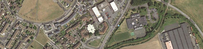
CONTENTS

SECTION 1           CONTEXT

1.1   Introduction .       .       .      .       .        .   .      .          4
1.2   Methodology .        .       .      .       .        .   .      .          4

SECTION 2           SCREENING MATRIX

2.1   Description of Plan .        .      .       .        .   .      .       7
      2.1.1 Context        .       .      .       .        .   .      .       7
      2.1.2 Location of Project lands     .       .        .   .      .       8
      2.1.3 Structure and Content of the Project Report.   .   .      .     10
      2.1.4 Vision and Rationale for the Plan Lands        .   .      .      11

2.2   Assessment of Relevance of Proposed Plan to Natura 2000 Sites   .          12

2.3   Avoidance of Impacts .       .      .       .        .   .      .          14

2.4   Other Instruments Considered        .       .        .   .      .          15

SECTION 3           DESCRIPTIONS OF NATURA 2000 SITES                 .          16

SECTION 4           ASSESSMENT OF POTENTIAL IMPACTS

4.1   Assessment of proposed LAP          .       .        .   .      .          20

4.2   Cumulative Effects   .       .      .       .        .   .      .          20

SECTION 5           CONCLUSIONS           .       .        .   .      .          21

Appendix 1   Descriptions of Relevant Natura 2000 sites .      .      .

Appendix 2   Relevance of Natura 2000 to the Castletymon Library Project lands        .

Appendix 3   Relevant County Development Plan Objectives       .      .

                                              3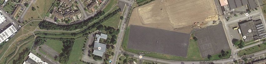
SECTION 1

1.1    INTRODUCTION

This document represents South Dublin County Council’s Appropriate Assessment (AA)
Screening Report for the Castletymon Library Project in South Dublin County. This report
has been prepared in accordance with the requirements of Article 6(3) of the Habitats
Directive (Directive 92/43/EEC).

Council directive 92/43/EEC on the conservation of natural habitats and of wild flora and
fauna – ‘The Habitats Directive’ was transposed into Irish law by the European Community
(Natural Habitats) Regulations 1997 (S.I. No. 94/1997).

Article 6 (3) of the ‘Habitats’ Directive 92/43/EEC states that;
Any plan or project not directly connected with or necessary to the management of the site but
likely to have a significant effect thereon, either individually or in combination with other
plans or projects, shall be subject to appropriate assessment of its implications for the site in
view of the sites conservation objectives. In the light of the conclusions of the assessment of
the implications for the site and subject to the provisions of paragraph 4, the competent
national authorities shall agree to the plan or project only after having ascertained that it will
not adversely affect the integrity of the site concerned and, If appropriate, after having
obtained the opinion of the general public.

Article 6(4) states:
'if, in spite of a negative assessment of the implications for the site and in the absence of
alternative solutions, a plan or project must nevertheless be carried out for imperative
reasons of overriding public interest, including those of economic or social nature, the
Member State shall take all compensatory measures necessary to ensure that the overall
coherence of Natura 2000 is protected. It shall inform the Commission of the compensatory
measures adopted. Where the site concerned hosts a priority natural habitat type and/or a
priority species the only considerations which may be raised are those relating to human
health or public safety, to beneficial consequences of primary importance for the environment
or, further to an opinion from the Commission, to other imperative reasons of overriding
public interest.

Article 6(3) therefore requires that an "appropriate assessment" be undertaken for any plan or
project which is not necessary for the management of a Natura 2000 site and which has the
potential to have an impact on the integrity of a Natura 2000 site i.e. a Special Area of
Conservation (SAC) or a Special Protection Area for Birds (SPA), or on the conservation
objectives of such a site.

Within the area of South Dublin County, there are two areas designated as SACs: Glenasmole
Valley SAC and a portion of the larger Wicklow Mountains SAC that extends into the county
area. There is also one SPA - a portion of the Wicklow Mountains SPA. These three Natura
2000 sites are all located in the Dublin Mountains, bordering with County Wicklow.

In effect, the Commission’s ruling requires a robust and thorough application by all consent
authorities, including planning authorities, of the requirement to undertake an appropriate
assessment of the ecological implications of any plan or project, whether within or outside of
a designated site, which may impact upon its stated conservation objectives.

                                                4
1.2    METHODOLOGY
This Screening Statement for Appropriate Assessment has been prepared with regard to the
following guidance documents where relevant:
    - Assessment of Plans and Projects Significantly Affecting Natura 2000 Sites:
       Methodological Guidance on the Provisions of Article 6(3) and (4) of the Habitats
       Directive 92/43/EEC (European Commission Environment Directorate General, 2001)

   -   Managing Natura 2000 Sites: The Provisions of Article 6 of the Habitats Directive
       92/43/EEC (EC Environment Directorate General, 2000)

   -   Appropriate Assessment under Article 6 of the Habitats Directive: Guidance for
       Planning Authorities Circular NPW 1/10 & PSSP 2/10

   -   Appropriate Assessment of Plans and Projects in Ireland – Guidance for Planning
       Authorities. (Department of Environment, Heritage and Local Government, 2010
       revision)

   -   Guidelines for Good Practice, Appropriate Assessment of Plans under Article 6(3)
       Habitats Directive (International Workshop on Assessment of Plans under the
       Habitats Directive, 2011)

   -   Guidance Document on Article 6(4) of the Habitats Directive 92/43/EEC.
       Clarification of the Concepts of Alternative Solutions, Imperative Reasons of Over-
       riding Public Interest, Compensatory Measures, Overall Coherence. Opinion of the
       European Commission (European Commission, January 2007)

There are four stages in an Appropriate Assessment as outlined in the European Commission
Guidance Document (2001), summarised below:

• Stage 1: Screening
The first step to establishing if an appropriate assessment is required is referred to as
'screening' and its purpose is to determine on the basis of a preliminary assessment and
objective criteria if the plan or project, alone or in combination with other plans or projects,
could have a significant effect on a Natura 2000 site in view of the sites conservation
objectives. The process identifies any likely impacts upon a Natura 2000 Site, either alone or
in combination with other projects or plans, and considers whether these impacts are likely to
be significant.

• Stage 2: Appropriate Assessment
This step considers the impact of the project or plan on the integrity of the Natura 2000 Site,
either alone or in combination with other plans or projects, to the site's structure and function
and its conservation objectives. Additionally, where there are deemed to be adverse impacts,
an assessment of the potential mitigation of those impacts is considered.

• Stage 3: Alternative Solutions
This stage examines alternative means of achieving the objectives of the project or plan that
aim to avoid adverse impacts on the integrity of the Natura 2000 site.

                                                5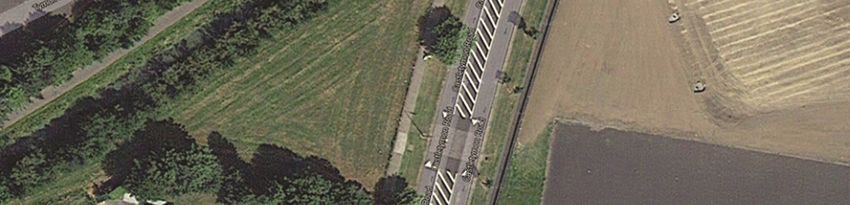
• Stage 4: Imperative Reasons of Overriding Public Interest
This stage is the main derogation process outlined in Article 6(4) which examines whether
there are imperative reasons of overriding public interest (IROPI) for allowing a plan or
project which will have adverse effects on the integrity of a Natura 2000 site to proceed.

This screening exercise was based on a desk-top study drawing on information sources which
included the following: NPWS on-line data for Natura 2000 sites; Ordnance Survey of Ireland
mapping and aerial photography; geological, hydrological and soils data available from GSI;
water quality data (EPA and SDCC); in-house data arising from site visits to proposed Project
lands.

The current documents present the results of the first of these four stages i.e. Screening, to
determine if the Castletymon Library Project will or will not have an impact on a Natura 2000
site. Its conclusion that significant impacts on Natura 2000 sites will not occur as a result of
this Project, resulted in the screening process terminating at Stage 1.

                                               6
SECTION 2 SCREENING MATRIX
2.1 DESCRIPTION OF THE PLAN OR PROJECT
2.1.1 Context
South Dublin County Council intends to develop a new library on the site adjacent to St
Aengus Church at the junction of Tymon North Gardens and Castletymon Road
Figure 1 Aerial view of the proposed development site context. (Source: Screen shots
from the website “googlemaps.com” on August 2016)
Figure 2 Site Location Map for the proposed development site. (Source: Screen shots
from the website “googlemaps.com” August 2016)
7The vision for the site is:
• To create a vibrant, high quality and accessible public facility along Castletymon Road
• To upgrade the public realm in the vicinity of the new development
The Proposal comprises of the construction of a new single storey public library with a total
area of 670 square meters and 50 square metres of plant room at roof level. Associated
development works will include landscaping and public realm improvements to the
surrounding area and the adjustment of existing footpath verges adjacent to the development
to allow for the creation of 13 parking spaces.
The new library will replace the existing facility at Castletymon Shopping Centre.
The design proposes to provide a new civic presence onto Castletymon Road and the building
has been set back from the adjoining church site to create a landscaped strip adding to the
quality of the existing church gardens and ensuring privacy to the house.
It is intended that the new building in conjunction with public realm improvements will
greatly enhance the character and appearance of the existing road and river frontage and
pedestrian route, improving passive oversight of the public roadway and the pedestrian
walkway along the stream. Access to the library will be from Castletymon Road
2.1.2 Location and description of the Project site
The site is located on a triangular plot adjoining Catholic Church on Castletymon Road and
adjacent to Tymon North Gardens. It is bounded by Castletymon Road to the east, Saint
Aengus' Church, Castle Park, to the south and Tymon North Gardens to the north and east. A
tree-lined stream runs along the north western boundary and forms a clear physical separation
between the site and the pedestrian route adjacent to Tymon North Gardens. This stream rises
in Cookstown and forms the Tymon River which becomes the River Poddle downstream of
Tymon Park. The stream is culverted at the north end of the site where it crosses under
Castletymon Road
Figure 3 Aerial view of the proposed development site from the south. (Source: Screen
shots from the website “googlemaps.com” August 2016)
8Figure 4 Site Plan of the proposed development
The site area is .122 Hectare (.3 acres) It is a compact site, unconstrained by utilities.
There are no public services or utilities traversing the site. At this stage no unusual problems
are anticipated regarding the topography. Existing services and utilities are available to
service the building.
There is no history of flooding on the site. While the building is designed to overlook the
existing stream and pedestrian walkway it is sufficiently set back from this boundary to avoid
any interference with the river bank.
The site layout and building have been designed to ensure that there will be no direct input
into the existing watercourse either during the course of the development works or the life of
the building. It is proposed to incorporate a green roof on the building to minimise surface
water run-off from the site and any surplus run-off from the site will be filtered through silt
traps and petrol interceptors before discharge into surface-water system.
2.1.3 Structure and Content of the the Castletymon Library Project Report
The purpose of the project report is to explain the rationale behind the choice of site and
location of the development and the consideration that has been given to the mitigation of
impact on the natural environment in so much as possible while achieving the development
of the this community amenity.
92.2 ASSESSMENT OF RELEVANCE OF PROPOSED PLAN TO NATURA 2000
SITES
The Castletymon Library Project is not directly connected with or necessary to the
management of Natura 2000 sites in South Dublin County or elsewhere.
Best practice recommends assessing Natura 2000 sites located within 15km of a proposed
plan or project (see Figure 3). These Natura 2000 sites are listed in Table 1.
Figure 5 Relevance of Natura 2000 sites to the Castletymon Library Project Lands
For the Castletymon Library Project lands, the sites of relevance requiring screening
assessment are the following:
• three Natura 2000 sites within South Dublin County (Glenasmole Valley SAC,
Wicklow Mountains SAC, and Wicklow Mountains SPA)
• the suite of Natura 2000 sites located downstream of the Project lands in Dublin Bay
(North Dublin Bay SAC, South Dublin Bay SAC, South Dublin Bay and River Tolka
Estuary SPA, and North Bull Island SPA)
• one sites in County Kildare (Rye Water/Carton SAC)
There are no Natura 2000 sites located either within or directly adjacent to the proposed
Project lands. For the Natura 2000 sites located within County Wicklow and County Kildare,
there are no direct ecological or hydrological links (source-pathway-receptors) between the
proposed Project lands and these Natura 2000 sites. Negative impacts on these sites are
therefore highly unlikely by virtue of distance from the Castletymon Library Project site and
the absence of source-pathway-receptors.
10TABLE 1. Natura 2000 sites within 15km of the proposed the Castletymon Library
Project site.
Natura 2000 sites Site Other Natura 2000 sites within 15km of Site
within South Dublin Code proposed Project site Code
County
Glenasmole Valley 001209 North Dublin Bay SAC 000206
SAC 002122 South Dublin Bay SAC 000210
Wicklow Mountains 004040 South Dublin Bay and River Tolka Estuary 004024
SAC SPA 004006
Wicklow Mountains North Bull Island SPA
SPA
Rye Water Valley/Carton SAC, Co. Kildare 001398
Within South Dublin County, the Castletymon Library Project lands are also distant from the
Glenasmole Valley SAC which is approximately 6km SE of the Plan Lands. The Project
Lands are also approximately 8km NW of the Wicklow Mountains SAC and Wicklow
Mountains SPA. As the the Castletymon Library Project Lands are located at such a distance,
and in a separate river catchment area to these three Natura 2000 sites, there are no relevant
source-pathway-receptors connecting the Project lands to these Natura 2000 sites. Negative
impacts on these Natura 2000 sites are therefore also highly unlikely.
As there is a stream running alongside the proposed Project lands which could act as a source-
pathway-receptor between the Project lands and the suite of Natura 2000 sites in Dublin Bay
downstream of the Project site, a possible hydrological connection is deemed to exist by
virtue of the foul and surface water drainage systems in the Tallaght area.
Surface water drainage is facilitated via a county-wide surface water drainage system which
ultimately discharges into Dublin Bay. The plan lands are serviced by the Eastern River
Basin District drainage network, this network discharges into the Liffey and Dublin Bay via
the Poddlie and Camac
Foul water drainage from the plan lands is transported via piped systems to the wastewater
treatment plan to Ringsend. The Council is cognisant of the need to ensure the requisite
wastewater treatment provision in respect of the foul drainage network to allow for
development growth without which the development would conflict with the requirements of
the Urban Wastewater Treatment Directive which requires the collection and high level
treatment of wastewater, specifically those to be discharged to sensitive waters such as Dublin
Bay (the terms of the recent EPA operating license reinforce this aspect).
112.3 AVOIDANCE OF IMPACTS
The development of the Castletymon Library Project was an iterative process which worked
to inform the development of appropriate policies and objectives from the earliest stages of
the plan’s preparation process. As a result, there are a number of policies and objectives
already in place that relate to general environmental protection throughout the proposed
Project lands.
The relevance of the proposed Project to the Natura 2000 network was assessed above in
Section 2.2 where the only potentially relevant impact was seen to arise from a hydrological
link (via the foul and surface water drainage system and the Eastern River Basin District
drainage network) that exists between the Project lands and the Dublin Bay Natura 2000 sites.
The full range of policies and objectives contained within the South Dublin County Council
Development Plan 2016 – 2020 will also apply to all development proposals such as the the
Castletymon Library Project. The SDCC County Development Plan contains a number of
policies and objectives that relate to the protection of the environment, landscape, water
quality, and Natura 2000 sites. The protection of SACs and pNHAs is specifically referred to
in HCL Policy 12 Natura 2000 Sites:
HERITAGE, CONSERVATION AND LANDSCAPES (HCL) Policy 12 Natura 2000
Sites.
It is the policy of the Council to support the conservation and improvement of Natura 2000
Sites and to protect the Natura 2000 network from any plans and projects that are likely to
have a significant effect on the coherence or integrity of a Natura 2000 Site.
The requirements for appropriate assessment of potential impacts on Natura 2000 sites are
detailed in objectives 1 and 2 of this policy:
HCL12 Objective 1:
To prevent development that would adversely affect the integrity of any Natura 2000 site
located within and immediately adjacent to the County and promote favourable conservation
status of habitats and protected species including those listed under the Birds Directive, the
Wildlife Acts and the Habitats Directive.
HCL12 Objective 2:
To ensure that projects that give rise to significant direct, indirect or secondary impacts on
Natura 2000 sites, either individually or in combination with other plans or projects, will not
be permitted unless the following is robustly demonstrated in accordance with Article 6(4) of
the Habitats Directive and S.177AA of the Planning and Development Act (2000 – 2010) or
any superseding legislation:
1. There are no less damaging alternative solutions available; and
2. There are imperative reasons of overriding public interest (as defined in the
Habitats Directive) requiring the project to proceed; and
3. Adequate compensatory measures have been identified that can be put in place.
A range of other policies in the County Development Plan 2016-2022 relate to water quality
waste water treatment and green infrastructure, all of which aim to eliminate or reduce the
12potential for deterioration of water quality, both ground water and surface water (see
Appendix 3).
For the the Castletymon Library Project, its broad objectives were assessed to determine
whether or not the potential existed for these to have a significant negative impact on the
Natura 2000 network. The nature of the proposed development comprises of the construction
of a new building on the existing green field site. No additional surface soil or materials that
could contain contaminants will be imported onto the site. The development will be served by
the existing public infrastructure adjoining the site and the scale and nature of the
development is such that is will not place additional constraints on that infrastructure
Avoidance and mitigation measures will be taken in the design and use of the building to
ensure that biodiversity and water quality will be protected. These measures include the
installation of a green roof drainage system, silt and petrol interceptor, avoidance of impact on
watercourse during construction, step-back and retention of hedgerow, use of bat sensitive
lighting design along the hedgerow side.
The size and nature of the Castletymon Library Project in conjunction with the adherence to
avoidance and mitigation measures outlined above and the adherence to the over-arching
policies listed in the County Development Plan 2016-2022 are highly unlikely to result in
negative impacts on Natura 2000 sites given that they are at a distance of over 15km from the
the Castletymon Library Project site.
Adherence to these County Development Plan’s protective policies and objectives (relevant
objectives listed in Appendix 3), will therefore act to avoid significant downstream impacts
on Natura 2000 sites.
2.4 OTHER INSTRUMENTS CONSIDERED
The proposed the Castletymon Library Project was considered in the context of a range of
other higher level measures, all of which assist in mitigating any potential impacts of the
proposed plan. These include the following National Plans, Regional Plans and Local Plans:
Sustainable Development – A Strategy for Ireland (1997); National Spatial Strategy 2002-
2020; National Climate Change Strategy, 2000; National Heritage Plan (2002); The Planning
System and Flood Risk Management Guidelines 2009; Regional Planning Guidelines 2010 –
2020: A Platform For Change And Transport 21; Sustainable Residential Development In
Urban Areas 2009; The Retail Planning Strategy For The Greater Dublin Area (2008-2016);
South Dublin County Council Development Plan 2010 – 2016; Green City Guidelines’ (UCD
Urban Institute Ireland 2008).
13SECTION 3 DESCRIPTION OF NATURA 2000 SITES
There are no Natura 2000 sites located within the proposed the Castletymon Library Project
site. The Natura 2000 sites located within 15km of the Project site are listed in Table 1.
There are also two proposed Natural Heritage Area (pNHA) in the vicinity of the Project
lands. The Grand Canal pNHA (Site Code: 002104) is located c.3km to the north of the
Project site the Dodder Valley pNHA (Site Code: 000991) is located c. 2km south east of the
Project lands. There are no other designated biodiversity areas in the vicinity of the proposed
the Castletymon Library Project site which have a recognised National, European Union or
International protection status.
Full site descriptions of the Natura 2000 sites listed in Table 1 are provided in Appendix 1. A
summary of the main elements of interest for each of these sites follows:
Glenasmole Valley SAC contains a high diversity of habitats and plant communities and lists
three habitats listed on Annex I of the EU Habitats Directive: petrifying springs with tufa
formation, semi-natural dry grassland and scrubland facies on calcareous substrate (Festuco-
Brometalia) (important orchid sites), and Molinia meadows on calcareous, peaty, or clayey-
silt-laden soils (Molinion caeruleae). Both petrifying springs and orchid-rich calcareous
grasslands also qualify as Priority Habitats under the Habitats Directive. The presence of four
Red Data Book plant species further enhances the value of the site as does the presence of
populations of several mammal and bird species of conservation interest. The River Dodder
flows through the valley and has been impounded here to form two reservoirs which supply
water to south Dublin.
Draft Conservation Objectives:
1 To maintain the Annex 1 habitats for which the cSAC has been selected at
favourable conservation status – *Petrifying springs with tufa formation, Semi-
natural dry grassland and scrubland facies on calcareous substrates (Festuco-
Brometalia) (*important orchid sites), Molinia meadows on calcareous, peaty or
clayey-silt-laden soils (Molinion caeruleae)
2 To maintain the extent, species richness and biodiversity of the entire site.
3 To establish effective liaison and co-operation with landowners, legal users and
relevant authorities.
Wicklow Mountains SAC is an important complex, extensive, upland site covering much of
the Wicklow Mountains and a portion of the Dublin Mountain range. Within the boundaries
of South Dublin County, the SAC encompasses the mountains of Ballymorefinn, Corrig,
Kilakee, and Cruagh, stretching south to the summit of Kippure Mountain at the border with
County Wicklow. While the entire SAC lists ten habitats listed in Annex I of the EU Habitats
Directive, the vegetation within the South Dublin County portion of the site mainly provides
good examples of the typical upland habitats of heath, blanket bog and upland grassland.
Several rare, protected plant and animal species also occur in this SAC.
Draft Conservation Objectives:
1 To maintain the Annex 1 habitats for which the cSAC has been selected at favourable
conservation status:– Oligotrophic to mesotrophic standing waters with vegetation of
the Littorelletea uniflorae and/or of the Isoëto-Nanojuncetea; Natural dystrophic lakes
and ponds; Northern Atlantic wet heaths with Erica tetralix; European dry heaths;
Alpine and Boreal heaths; Species-rich Nardus grasslands, on siliceous substrates in
14mountain areas (and submountain areas, in Continental Europe); Blanket bog;
Siliceous scree of the montane to snow levels; (Androsacetalia alpinae and
Galeopsietalia ladani); Calcareous rocky slopes with chasmophytic vegetation;
Siliceous rocky slopes with chasmophytic vegetation; Old sessile oak woods with Ilex
and Blechnum in British Isles.
2 To maintain the Annex 2 species for which the cSAC has been selected at favourable
conservation status: - Lutra lutra
3 To maintain the extent, species richness and biodiversity of the entire site.
4 To establish effective liaison and co-operation with landowners, legal users and
relevant authorities.
Wicklow Mountains SPA (Site Code 4040) is an extensive upland site, comprising a
substantial part of the Wicklow Mountains (See Appendix for full site description). The site,
which is within the Wicklow Mountains National Park, is fragmented into about twenty
separate parcels of land. Much of the site is State-owned and managed for nature conservation
based on traditional landuses for the uplands. The site is of high ornithological importance as
it supports very good examples of upland and woodland bird communities, several of which
are very rare at a national level. Two species, Ring Ouzel and Red Grouse, are Red-listed and
their status is of high conservation concern.
Main Conservation Objective:
To maintain the special conservation interests for the SPA at favourable conservation status –
Merlin, Peregrine.
Rye Water Valley/Carton (Site Code 001398)
This site is located between Leixlip and Maynooth in Co. Kildare. It extends along the Rye
Water, a tributary of the River Liffey. The woodlands at Carton Demesne are the site of a
rare fungus, Diderma deplanatum and also support birds such as Blackcap, Woodcock, and
Long-eared Owls. On or about the lake, birds such as Little Grebe, Coot, Moorhen, Tufted
Duck, Teal, and Kingfisher have been recorded. Kingfisher are listed in Annex 1 of the EU
Birds Directive. The mineral spring occurring on the site is also listed as an Annex 1 habitat
of the EU Habitats Directive. The Rye Water is a spawning ground for Trout and Salmon
while White-clawed crayfish Austropotomobius pallipeshas been recorded at Leixlip. Rare
snail species and dragonflies also occur in the marsh vegetation near to Louisa Bridge. The
main importance of the site lies in the presence of several rare and threatened plant and
animal species and of a rare habitat – thermal, mineral, petrifying spring.
Draft Conservation Objectives:
1. To maintain the Annex 1 habitats for which the cSAC has been selected at
favourable conservation status:– *Petrifying springs with tufa formation
2. To maintain the Annex 2 species for which the cSAC has been selected at
favourable conservation status: - Vertigo angustior, Vertigo moulinsiana
3. To maintain the extent, species richness and biodiversity of the entire site.
4. To establish effective liaison and co-operation with landowners, legal users and
relevant authorities.
North Dublin Bay SAC (Site Code 000206) covers the inner part of north Dublin Bay, the
seaward boundary extending from the Bull Wall lighthouse across to the Martello Tower at
Howth Head (See Appendix for full site description). The North Bull Island is the focal point
of this site. This SAC site is an excellent example of a coastal site with all the main habitats
15represented. It holds good examples of ten habitats that are listed on Annex I of the E.U.
Habitats Directive; one of these is listed with priority status. Several wintering bird species
have populations of international importance, while some invertebrates on the site are of
national importance. The site also contains a numbers of rare and scarce plants including
some which are legally protected.
Draft Conservation Objectives:
1. To maintain the Annex 1 habitats for which the cSAC has been selected at favourable
conservation status:– Mudflats and sandflats not covered by seawater at low tide;
Annual vegetation of drift lines; Salicornia and other annuals colonising mud and
sand; Atlantic salt meadows (Glauco Puccinellietalia maritimae); Petalophyllun
ralfsii; Mediterranean salt meadows (Juncetalia maritimi); Embryonic shifting dunes;
Shifting dunes along the shoreline with Ammophila arenaria (white dunes); Fixed
coastal dunes with herbaceous vegetation (grey dunes); Humid dune slacks
2. To maintain the extent, species richness and biodiversity of the entire site.
3. To establish effective liaison and co-operation with landowners, legal users and
relevant authorities.
South Dublin Bay SAC (Site Code 000210) lies south of the River Liffey and extends from
the South Wall to the west pier at Dun Laoghaire (See Appendix for full site description). It
is a fine example of a coastal system with extensive sand and mudflats. South Dublin Bay is
also an internationally important bird site.
Draft Conservation Objectives:
1. To maintain the Annex 1 habitats for which the cSAC has been selected at
favourable conservation status: - Mudflats and sandflats not covered by
seawater at low tide.
2. To maintain the extent, species richness and biodiversity of the entire site.
4 To establish effective liaison and co-operation with landowners, legal users and
relevant authorities.
South Dublin Bay and River Tolka Estuary SPA (Site Code 4024) comprises a substantial
part of Dublin Bay. It includes the intertidal area between the River Liffey and Dun
Laoghaire, and the estuary of the River Tolka to the north of the River Liffey, as well as
Booterstown Marsh. A portion of the shallow marine waters of the bay is also included (See
Appendix for full site description).
The site is an important site for wintering waterfowl, being an integral part of the
internationally important Dublin Bay complex. It is of international importance for Light-
bellied Brent Goose and of national importance for nine other waterfowl species. As an
autumn tern roost, it is also of international importance. Furthermore, the site supports a
nationally important colony of Common Tern. All of the tern species using the site are listed
on Annex I of the E.U. Birds Directive, as are Bartailed Godwit and Mediterranean Gull.
Main Conservation Objective:
To maintain the special conservation interests for the SPA at favourable conservation status –
Light-bellied Brent Goose, Oystercatcher, Ringed Plover, Golden Plover, Knot, Sanderling,
Dunlin, Bar-tailed Godwit, Redshank, Black-headed Gull, Roseate Tern, Common Tern,
Arctic Tern, and Wetland and Waterbirds.
16SECTION 4 ASSESSMENT OF POTENTIAL IMPACTS
4.1 ASSESSMENT OF PROPOSED THE CASTLETYMON LIBRARY PROJECT
In Section 2.2 (Assessment of relevance of proposed Plan to Natura 2000 Sites), a potential
hydrological link was identified as being the primary source-pathway-receptor between the
proposed Project site and Natura 2000 sites – primarily the Dublin Bay Natura 2000 sites. No
other hydrological or ecological links to other Natura 2000 sites within 15km of the Project
lands was identified as posing a potential threat. This hydrological link via the County’s foul
surface water drainage system thereby potentially provides a vehicle for the transfer of
negative impacts to these Natura 2000 sites downstream of the Project lands which rely on
water quality for the maintenance of their conservation objectives.
An assessment of the extent and nature of the proposed Project was undertaken in section 2.3
above and no significant impacts were identified.
The proposed Project was assessed following the factors as listed: - size and scale; land-take;
distance from the Natura 2000 site or key features of the site; resource requirements (water
abstraction etc.); emissions (disposal to land, water, or air); excavation requirements);
transportation requirements; duration of construction, operation, decommissioning, etc.;
habitat area; disturbance to key species; habitat or species fragmentation; species density;
changes in key indicators of conservation value (water quality etc.); climate change; key
relationships that define the structure of the site; key relationships that determine the function
of the site.
The nature and extent of the works proposed, in conjunction with the over-arching policies of
the South Dublin County Development Plan 2016-2022 within which framework the
Castletymon Library Project is placed, all serve to ensure that no significant negative impact
arises from the proposed Plan.
4.2 CUMULATIVE IMPACTS
The National Spatial Strategy 2002-2020 and the National Development Plan 2007-2013 set
the national planning framework within which the proposed Clondalkin Round Tower Project
has been prepared. Within South Dublin County itself, the County Development Plan 2016-
2022 provides the local framework within the regional approach of the Regional Planning
Guidelines 2010-2020. These documents have been subject to screening for Appropriate
Assessment to ensure no significant impacts are likely. The proposed the Castletymon
Library Project has been prepared taking the objectives and policies of these plans into
account.
The assessment for the proposed the Castletymon Library Project indicates there will be no
significant impacts arising from this plan. In relation to potential cumulative impacts from the
proposed Project in conjunction with other plans and projects, it is a requirement that each of
these, in addition to the proposed Project itself, will all be subject to screening for appropriate
assessment to ensure there will be no significant negative impact on Natura 2000 sites. Taken
together, adherence to this required approach will ensure no cumulative impacts will arise
from these plans.
17SECTION 5 CONCLUSIONS
This screening report has evaluated the proposed the Castletymon Library Project to
determine whether or not significant negative impacts on Natura 2000 sites are likely to arise
by virtue of the Plan’s implementation. The report finds that the Plan has been formulated to
ensure that developments and effects arising from the Plan, either individually or in
combination with other plans and projects, shall not give rise to significant effects on the
integrity of any Natura 2000 site.
The Appropriate Assessment procedure for this proposed Plan is therefore concluded at this
Screening Stage and a detailed (Stage 2) Appropriate Assessment is not required.
18Appendix 1
Natura 2000 descriptions (as listed in Table 1)
19SITE SYNOPSIS
SITE NAME: GLENASMOLE VALLEY
SITE CODE: 001209
Glenasmole Valley in south Co. Dublin lies on the edge of the Wicklow uplands,
approximately 5 km from Tallaght. The River Dodder flows through the valley and has been
impounded here to form two reservoirs which supply water to south Dublin. The non-
calcareous bedrock of the Glenasmole Valley has been overlain by deep drift deposits which
now line the valley sides. They are partly covered by scrub and woodland, and on the less
precipitous parts, by a herb-rich grassland. There is much seepage through the deposits, which
brings to the surface water rich in bases, which induces local patches of calcareous fen and, in
places, petrifying springs, a priority habitat listed on Annex I of the EU Habitats Directive.
Examples of calcareous fen and flush areas occur between the two reservoirs, where sedges
(Carex flacca and Carex panicea) are joined by such species as Grass of Parnassus
(Parnassia palustris), Few-flowered Spike-rush (Eleocharis quinqueflora), Zig-zag clover
(Trifolium medium) and the scarce Fen Bedstraw (Galium uliginosum).
Orchid-rich grassland occurs in the drier parts of this site and in places grades into Molinia
meadow, both of these habitats are listed on Annex I of the EU Habitats Directive. Species
recorded in these habitats include Frog Orchid (Coeloglossum viride), Northern Marsh-orchid
(Dactylorhiza purpurella), Fragrant Orchid (Gymnadenia conopsea), Marsh Helleborine
(Epipactis palustris), Early-purple Orchid (Orchis mascula) and Greater Butterfly Orchid
(Platanthera chlorantha).
Two Red Data Book species have also been found here, Green-winged Orchid (Orchis
morio) and Small-white Orchid (Pseudorchis albida). The sward includes Sweet Vernal-grass
(Anthoxanthum odoratum), Creeping Bent (Agrostis stolonifera) and Crested Dog's-tail
(Cynosurus cristatus). Other species which occur are Common Bird's-foot-trefoil (Lotus
corniculatus), Kidney Vetch (Anthyllis vulneraria), Common Restharrow (Ononis repens),
Yellow-wort (Blackstonia perfoliata) and Autumn Gentian (Gentianella amarella).
Woodland occurs in patches around the site. On the east side of the valley, below the northern
lake, a Hazel (Corylus avellana) wood has developed on the unstable calcareous slopes and
includes Ash (Fraxinus excelsior), Downy Birch (Betula pubescens), Goat Willow (Salix
caprea) and (Irish) Whitebeam (Sorbus hibernica). Spring Wood-rush (Luzula pilosa), Wood
Speedwell (Veronica montana) and Brambles (Rubus fruticosus agg.) are included in the
ground flora.
Wet semi-natural broad-leaved woodland is also found around the reservoirs and includes
Alder (Alnus glutinosa) and Willow (Salix spp.) with Yellow Iris (Iris pseudacorus), Horsetail
(Equisetum spp.), Brambles and localised patches of Japanese Knotweed (Reynoutria
japonica), an introduced species.
The lake shore vegetation is not well developed, which is typical of a reservoir. There are
occasional patches of Canary-grass (Phalaris arundinacea) and Purple-loosestrife (Lythrum
salicaria), which are more extensive around the western shore of the northern lake, along with
Common Marsh-bedstraw (Galium palustre) and Water Mint (Mentha aquatica). Other
20vegetation includes Shoreweed (Littorella uniflora) and the scarce Water Sedge (Carex
aquatilis).
As well as the Green-winged Orchid and Small-white Orchid, two other threatened species
which are listed in the Irish Red Data Book also occur in the site, Yellow Archangel
(Lamiastrum galeobdolon) and Yellow Bird's-nest (Monotropa hypopitys).
The site provides excellent habitat for bat species, with at least four species recorded:
Pipistrelle, Leisler’s, Daubenton’s and Brown Long-eared Bat. Otter occurs along the
river and reservoirs. These habitats also support Kingfisher, an Annex I species under
the EU Birds Directive.
Glenasmole Valley contains a high diversity of habitats and plant communities, including
three habitats listed on Annex I of the EU Habitats Directive. The presence of four Red Data
Book plant species further enhances the value of the site as does the presence of populations
of several mammal and bird species of conservation interest.
03.09.2001
SITE SYNOPSIS
SITE NAME: WICKLOW MOUNTAINS
SITE CODE: 002122
This site is a complex of upland areas in Counties Wicklow and Dublin, flanked by
Blessington Reservoir to the west and Vartry Reservoir in the east, Cruagh Mt. in the north
and Lybagh Mt. in the south. Most of the site is over 300m, with much ground over 600m and
the highest peak of Lugnaquilla at 925m.
The Wicklow Uplands comprise a core of granites flanked by Ordovician schists, mudstones
and volcanics. The form of the Wicklow Glens is due to glacial erosion. The Wicklow
Mountains are drained by several major rivers including the Dargle, Liffey, Dodder, Slaney
and Avonmore. The river water in the mountain areas is often peaty, especially during floods.
The topography is typical of a mountain chain, showing the effects of more than one cycle of
erosion. The massive granite has weathered characteristically into broad domes. Most of the
western part of the site consists of an elevated moorland, covered by peat. The surrounding
schists have assumed more diverse outlines, forming prominent peaks and rocky foothills with
deep glens. The dominant topographical features are the products of glaciation. High corrie
lakes, deep valleys and moraines are common features of this area. The substrate over much
of the area is peat, usually less than 2m deep. Poor mineral soil covers the slopes and rock
outcrops are frequent.
The vegetation over most of the site is a mosaic of heath, blanket bog and upland grassland
(mostly on peaty soil, though some on mineral soil), with stands of dense Bracken (Pteridium
aquilinum) and small woodlands mainly along the rivers. Mountain loughs and corrie lakes
are scattered throughout the site. The site supports many habitats that are listed on Annex I of
the E.U. Habitats Directive.
The two dominant vegetation communities in the area are heath and blanket bog. Heath
vegetation, with both wet and dry heath well represented, occurs in association with blanket
21bog, upland acid grassland and rocky habitats. The wet heath is characterised by species such
as Ling (Calluna vulgaris), Cross-leaved Heath (Erica tetralix), Cottongrasses (Eriophorum
spp.), Tormentil (Potentilla erecta), Mat-grass (Nardus stricta), Bent grasses (Agrostis spp.)
and bog mosses (Sphagnum spp.). In places the wet heath occurs in conjunction with flush
communities and streamside vegetation, and here species such as Heath Rush (Juncus
squarrosus) and Carex spp. are found. Dry heath at this site is confined to shallow peaty soils
on steep slopes where drainage is better and particularly in sheltered conditions. It is
characterised by species such as Ling, Gorse (Ulex spp.), Bell Heather (Erica cinerea),
Bilberry (Vaccinium myrtillus), Purple Moor-grass (Molinia caerulea) and lichens (Cladonia
spp.). In places the heath grades into upland grassland on mineral soil, some examples of
which correspond to the E.U. Habitats Directive Annex I priority habitat species-rich Nardus
grassland.
Blanket bog is usually dominated by Cottongrasses, Ling and bog mosses (Sphagnum spp.).
On steeper slopes there is some flushing and here Purple Moor-grass, Heath Rush, and certain
Sphagnum species become more common. The Liffey Head blanket bog is among the best of
its kind in eastern Ireland, with deep peat formations and an extensive system of dystrophic
pools developed among the hummocks and hollows on the bog surface. The vegetation is
largely dominated by Ling and Cross-leaved Heath, with Cottongrasses (Eriophorum
vaginatum and E. angustifolium), Deergrass (Scirpus cespitosus) and Bog Asphodel
(Narthecium ossifragum). In drier areas, Bilberry and Cowberry (Vaccinium vitis-idaea) are
common, while the scarce Bog Rosemary (Andromeda polifolia) is also found. Blanket bog
occurs over extensive areas of deeper peat on the plateau and also on gentle slopes at high
altitudes. Peat erosion is frequent on the peaks - this may be a natural process, but is likely to
be accelerated by activities such as grazing.
Due to the underlying rock strata, the water of the rivers and streams tends towards acidity.
The water is generally oligotrophic and free from enrichment. The lakes within the area range
from the high altitude lakes of Lough Firrib and Three Lakes, to the lower pater-noster lakes
of Glendalough, Lough Tay and Lough Dan. Spectacular corrie lakes (such as Loughs Bray
(Upper and Lower), Ouler, Cleevaun, Arts, Kellys and Nahanagan) exhibit fine sequences of
moraine stages. The deep lakes are characteristically species poor, but hold some interesting
plants including an unusual form of Quillwort (Isoetes lacustris var. morei), a Stonewort
(Nitella sp.) and Floating Bur-reed (Sparganium angustifolium). The Red Data Book fish
species Arctic Char has been recorded from Lough Dan, but this population may now have
died out.
Alpine vegetation occurs on some of the mountain tops, notably in the Lugnaquilla area, and
also on exposed cliffs and scree slopes elsewhere in the site. Here alpine heath vegetation is
represented with species such as Crowberry (Empetrum nigrum), Cowberry, Dwarf Willow
(Salix herbacea), the grey-green moss Racomitrium lanuginosum and scarce species such as
Mountain Clubmoss (Diphasiastrum alpinum), Firmoss (Huperzia selago), and Starry
Saxifrage (Saxifraga stellaris). Some rare arctic-alpine species have been recorded, including
Alpine Lady’s-mantle (Alchemilla alpina) and Alpine Saw-wort (Saussurea alpina).
Small areas of old oakwood (Blechno-Quercetum petraeae type) occur on the slopes of
Glendalough and Glenmalure, near L. Tay and L. Dan, with native Sessile Oak (Quercus
petraea) 100-120 years old. On wetter areas, wet broadleaved semi-natural woodlands occur,
which are dominated by Downy Birch (Betula pubescens). Mixed woodland with non-native
tree species also occurs.
22The site supports a range of rare plant species, which are listed in the Irish Red Data Book:
Parsley Fern (Cryptogramma crispa), Marsh Clubmoss (Lycopodiella inundata), Greater
Broom-rape (Orobanche rapum-genistae), Alpine Lady's-mantle, Alpine Saw-wort,
Lanceolate Spleenwort (Asplenium billotii), Small White Orchid (Pseudorchis albida) and
Bog Orchid (Hammarbya paludosa). The latter three species are legally protected under the
Flora (Protection) Order, 1999. The rare Myxomycete fungus, Echinostelium colliculosum,
has been recorded from the Military Road.
Mammals and birds which occur are typical of the uplands. Deer are abundant, mainly
hybrids between Red and Sika Deer. Other mammals include Hare, Badger and Otter, the
latter being a species listed on Annex II of the E.U. Habitats Directive. Pine Marten has
recently been confirmed as occurring within the site. Among the birds, Meadow Pipit,
Skylark, Raven and Red Grouse are resident throughout the site. Wheatear, Whinchat and the
scarce Ring Ouzel are summer visitors. Wood Warbler and Redstarts are rare breeding species
of the woodlands. Dipper and Grey Wagtail are typical riparian species. Merlin and Peregrine
Falcon, both Annex I species of the EU Birds Directive, breed within the site. Recently,
Goosander has become established as a breeding species.
Large areas of the site are owned by NPWS, and managed for nature conservation based on
traditional landuses for the uplands. The most common landuse is traditional sheep grazing.
Other land uses include turf-cutting, mostly hand-cutting but some machine-cutting occurs.
These activities are largely confined to the Military Road, where there is easy access. Large
areas which had been previously hand-cut and are now abandoned, are regenerating. In the
last 40 years, forestry has become an important landuse in the uplands, and has affected both
the wildlife and the hydrology of the area. Amenity use is very high, with Dublin city close to
the site.
Wicklow Mountains is important as a complex, extensive upland site. It shows great diversity
from a geomorphological and a topographical point of view. The vegetation provides
examples of the typical upland habitats with heath, blanket bog and upland grassland covering
large, relatively undisturbed areas. In all ten habitats listed on Annex I of the EU Habitats
Directive are found within the site. Several rare, protected plant and animal species occur.
12.10.2001
SITE SYNOPSIS
SITE NAME: WICKLOW MOUNTAINS SPA
SITE CODE: 004040
This is an extensive upland site, comprising a substantial part of the Wicklow Mountains. The
underlying geology of the site is mainly of Leinster granites, flanked by Ordovician schists,
mudstones and volcanics. The area was subject to glaciation and features fine examples of
glacial lakes, deep valleys and moraines. Most of site is over 300 m, with much ground being
over 600 m; the highest peak is Lugnaquillia (925 m). The substrate over much of site is peat,
with poor mineral soil occurring on the slopes and lower ground. Exposed rock and scree are
features of the site.
The dominant habitats present are blanket bog, heaths and upland grassland. The bog habitat
is usually dominated by Ling (Calluna vulgaris), Cross-leaved Heath (Ericatetralix),
Cottongrasses (Eriophorum vaginatum and E. angustifolium), Deergrass (Scirpus cespitosus)
23and Bog Asphodel (Narthecium ossifragum). Bog mosses (Sphagnum spp.) are well
represented. On shallower peats, dry heath is represented by such species as Ling, Gorse
(Ulex spp.), Bell Heather (Erica cinerea), Bilberry (Vaccinium myrtillus), Purple Moor-grass
(Molinia caerulea) and lichens (Cladonia
spp.). Fine examples of native Oak woodlands are found in the Glendalough area, and include
Sessile Oak (Quercus petraea) trees of 100-120 years old. Glendalough Lake is a good
example of an oligotrophic system.
The site supports good examples of both upland and woodland bird communities. The open
peatlands provide excellent foraging habitat for Merlin (5-10 pairs) and Peregrine (c. 10
pairs). The Merlins nest in old crows nests, whilst the Peregrines nest on cliffs and crags.
Other birds of the open peatlands and scree slopes include Ring Ouzel, now a very rare bird in
Ireland, and Red Grouse. The Wicklow uplands are the only regular location in Ireland where
Goosander breeds, with the Glendalough lakes being a regular site. This species was proved
to be breeding only as recently as 1994 and it is now well established. Whinchat, a localised
species in Ireland, breeds within the site.
The Glendalough Oak woods are a regular location for several rare breeding passerines.
Redstart is recorded most years and 1-2 pairs probably breed. Wood Warbler is another
annual visitor, with perhaps up to 5 pairs in some years. Recently, Garden Warbler has been
recorded, whilst Blackcap has a very strong breeding population.
The site, which is within the Wicklow Mountains National Park, is fragmented into about
twenty separate parcels of land. Much of the site is State-owned and managed for nature
conservation based on traditional landuses for the uplands. The most common landuse is
traditional sheep grazing. Other land uses include turf-cutting, mostly by hand though some
machine-cutting also occurs. Grazing by sheep and deer in the woodlands can be damaging as
it prevents or reduces regeneration. Dublin City is close to the site and amenity use is very
high; if not properly controlled, recreational activities could cause disturbance to some bird
species.
This site is of high ornithological importance as it supports very good examples of upland and
woodland bird communities. Several of the species which occur are very rare at a national
level. Two species, Ring Ouzel and Red Grouse, are Red-listed and their status is of high
conservation concern. Also of note is that Merlin and Peregrine are both listed on Annex I of
the E.U. Birds Directive.
25.8.2004
SITE SYNOPSIS
SITE NAME : NORTH DUBLIN BAY SAC
SITE CODE : 000206
This site covers the inner part of north Dublin Bay, the seaward boundary extending from the
Bull Wall lighthouse across to the Martello Tower at Howth Head. The North Bull Island is
the focal point of this site. The island is a sandy spit which formed after the building of the
South Wall and Bull Wall in the 18th and 19th centuries. It now extends for about 5 km in
length and is up to 1 km wide in places.
24A well-developed and dynamic dune system stretches along the seaward side of the island.
Various types of dunes occur, from fixed dune grassland to pioneer communities on
foredunes. Marram Grass (Ammophila arenaria) is dominant on the outer dune ridges, with
Lyme Grass (Leymus arenarius) and Sea Couchgrass (Elymus farctus) on the foredunes.
Behind the first dune ridge, plant diversity increases with the appearance of such species as
Wild Pansy (Viola tricolor), Kidney Vetch (Anthyllis vulneraria), Bird's-foot Trefoil (Lotus
corniculatus), Rest Harrow (Ononis repens), Yellow Rattle (Rhinanthus minor) and
Pyramidal Orchid (Anacamptis
pyramidalis). In these grassy areas and slacks, the scarce Bee Orchid (Ophrys apifera) occurs.
About 1 km from the tip of the island, a large dune slack with a rich flora occurs, usually
referred to as the 'Alder Marsh' because of the presence of Alder trees (Alnus spp). The water
table is very near the surface and is only slightly brackish. Saltmarsh Rush (Juncus maritimus)
is the dominant species, with Meadow Sweet (Filipendula ulmaria) and Devil's-bit (Succisa
pratensis) being frequent. The orchid flora is notable and includes Marsh Helleborine
(Epipactis palustris), Common Twayblade (Listera ovata), Autumn Lady's-tresses
(Spiranthes spiralis) and Marsh orchids (Dactylorhiza spp.)
Saltmarsh extends along the length of the landward side of the island. The edge of the marsh
is marked by an eroding edge which varies from 20 cm to 60 cm high. The marsh can be
zoned into different levels according to the vegetation types present. On the lower marsh,
Glasswort (Salicornia europaea), Saltmarsh Grass (Puccinellia maritima), Annual Sea-blite
(Suaeda maritima) and Greater Sea-spurrey (Spergularia media) are the main species. Higher
up in the middle marsh Sea Plantain (Plantago maritima), Sea Aster (Aster tripolium), Sea
Arrowgrass (Triglochin maritima) and Sea Pink (Armeria maritima) appear. Above the mark
of the normal high tide, species such as Scurvy Grass (Cochlearia officinalis) and Sea
Milkwort (Glaux maritima) are found, while on the extreme upper marsh, Sea Rushes (Juncus
maritimus and J.
gerardii) are dominant. Towards the tip of the island, the saltmarsh grades naturally into fixed
dune vegetation.
The island shelters two intertidal lagoons which are divided by a solid causeway. The
sediments of the lagoons are mainly sands with a small and varying mixture of silt and clay.
The north lagoon has an area known as the "Salicornia flat", which is dominated by
Salicornia dolichostachya, a pioneer Glasswort species, and covers about 25 ha. Tassel Weed
(Ruppia maritima) occurs in this area, along with some Eelgrass (Zostera angustifolia).
Eelgrass (Z. noltii) also occurs in Sutton Creek. Cordgrass (Spartina anglica) occurs in places
but its growth is controlled by management. Green algal mats (Enteromorpha spp., Ulva
lactuca) cover large areas of the flats during summer. These sediments have a rich
macrofauna, with high densities of
Lugworms (Arenicola marina) in parts of the north lagoon. Mussels (Mytilus edulis) occur in
places, along with bivalves such as Cerastoderma edule, Macoma balthica and Scrobicularia
plana. The small gastropod Hydrobia ulvae occurs in high densities in places, while the
crustaceans Corophium volutator and Carcinus maenas are common. The sediments on the
seaward side of North Bull Island are mostly sands. The site extends below the low spring tide
mark to include an area of the sublittoral zone.
Three Rare plant species legally protected under the Flora Protection Order 1987 have been
recorded on the North Bull Island. These are Lesser Centaury (Centaurium pulchellum),
Hemp Nettle (Galeopsis angustifolia) and Meadow Saxifrage (Saxifraga granulata). Two
25further species listed as threatened in the Red Data Book, Wild Sage (Salvia verbenaca) and
Spring Vetch (Vicia lathyroides), have also been recorded. A rare liverwort, Petalophyllum
ralfsii, was first recorded from the North Bull Island in 1874 and has recently been confirmed
as being still present there. This species is of high conservation value as it is listed on Annex
II of the E.U. Habitats Directive. The North Bull is the only known extant site for the species
in Ireland away from the western seaboard.
North Dublin Bay is of international importance for waterfowl. During the 1994/95 to
1996/97 period the following species occurred in internationally important numbers (figures
are average maxima): Brent Geese 2,333; Knot 4,423; Bar-tailed Godwit 1,586. A further 14
species occurred in nationally important concentrations - Shelduck 1505; Wigeon 1,166; Teal
1,512; Pintail 334; Shoveler 239; Oystercatcher 2,190; Ringed Plover 346; Grey Plover 816;
Sanderling 357; Dunlin 6,238; Blacktailed Godwit 156; Curlew 1,193; Turnstone 197 and
Redshank 1,175. Some of these species frequent South Dublin Bay and the River Tolka
Estuary for feeding and/or
roosting purposes (mostly Brent Goose, Oystercatcher, Ringed Plover, Sanderling,
Dunlin).
The tip of the North Bull Island is a traditional nesting site for Little Tern. A high total of 88
pairs nested in 1987. However, nesting attempts have not been successful since the early
1990s. Ringed Plover, Shelduck, Mallard, Skylark, Meadow Pipit and Stonechat also nest. A
well-known population of Irish Hare is resident on the island The invertebrates of the North
Bull Island have been studied and the island has been shown to contain at least seven species
of regional or national importance in Ireland (Orders Diptera, Hymenoptera, Hemiptera).
The main landuses of this site are amenity activities and nature conservation. The North Bull
Island is the main recreational beach in Co Dublin and is used throughout the year. Much of
the land surface of the island is taken up by two golf courses. Two separate Statutory Nature
Reserves cover much of the island east of the Bull Wall and the surrrounding intertidal flats.
The site is used regularly for educational purposes.
North Bull Island has been designated a Special Protection Area under the E.U. Birds
Directive and it is also a statutory Wildfowl Sanctuary, a Ramsar Convention site, a
Biogenetic Reserve, a Biosphere Reserve and a Special Area Amenity Order site. This site is
an excellent example of a coastal site with all the main habitats represented. The holds good
examples of ten habitats that are listed on Annex I of the E.U. Habitats Directive; one of these
is listed with priority status. Several of the wintering bird species have populations of
international importance, while some of the invertebrates are of national importance. The site
contains a numbers of rare and scarce plants including some which are legally protected. Its
proximity to the capital city makes North Dublin Bay an excellent site for educational studies
and research.
23.11.1999
26You can also read