Spatial Assessment Need for Schools - London Borough of Tower Hamlets Tower Hamlets Local Plan: 2016-2031
←
→
Page content transcription
If your browser does not render page correctly, please read the page content below
London Borough of Tower Hamlets

Spatial Assessment
Need for Schools
Tower Hamlets Local Plan: 2016-2031
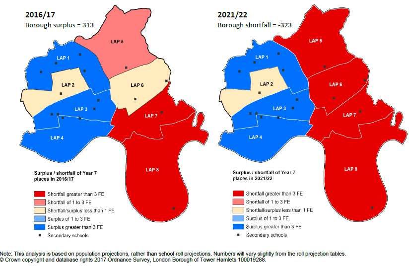
Table of Contents
1. Introduction...................................................................................................................... 3
2. Context ............................................................................................................................. 3
3. Spatial assessment of primary schools ............................................................................ 5
        Adopted Local Plan (2010 and 2013) and evidence base ............................................ 6
        The New Local Plan proposed submission (2018) and evidence base......................... 7
        Limitations of the evidence ........................................................................................ 10
        Allocating primary schools ......................................................................................... 11
4.      Spatial assessment of secondary schools .................................................................. 12
        Adopted Local Plan (2010 and 2013) and evidence base .......................................... 13
        The New Local Plan proposed submission (2018) and evidence base....................... 13
        Limitations of the evidence ........................................................................................ 14
        Allocating secondary schools ..................................................................................... 14
5.      Conclusion .................................................................................................................. 17
Appendices ......................................................................................................................... 18
     Appendix A: School roll projection: Reception (January 2018) ..................................... 19
     Appendix B: Free schools in Tower Hamlets .................................................................. 22
     Appendix C : Projects identified to help meet the need for primary schools................ 24
     Appendix D: Reception projections by LAP area ............................................................ 28
Appendix E: School roll projections: Secondary (January 2018) ........................................ 29
     Appendix F: Projects identified to help meet the need for secondary schools ............. 30
     Appendix G : Secondary projections by LAP area .......................................................... 33

                                                                                                                                        2
1. Introduction
      1.1 This exercise aims to support the approach taken to allocating schools as reflected in the
          Local Plan.

      1.2 It sets out the rationale for the number of sites allocated for primary and secondary schools,
          and the choice of locations to best address need. This assessment should be read alongside
          the Site Allocations Methodology (2018).

      1.3 This report provides detailed information regarding the assessment of the potential sites
          that were undertaken as part of the stage 2 Site Allocations Methodology (2017), which
          ensured that the most suitable and available sites were included and as informed by a
          number of evidence base studies.

      1.4 The council has a statutory duty to provide sufficient school places for the local population
          and a key means of achieving this is through the Local Plan. In order to ensure that there is
          sufficient capacity in the right places to accommodate primary and secondary school
          children within the Local Plan period (up to 2031), a number of sites have been identified for
          their delivery as part of wider comprehensive development. The borough’s school age
          population is rising and is projected to continue, due to high levels of anticipated growth in
          the borough. The vast majority of development and population growth is projected to occur
          in the east of the borough, and in particular in the Isle of Dogs and South Poplar. Therefore,
          these locations are generally the areas of focus in terms of site allocations for the provision
          of new schools.

 2. Context
 2.1 The Local Plan identifies four sub-areas to positively manage growth and development
     opportunities in the borough at a strategic level. These sub-areas are:

          a.   City Fringe
          b.   Central
          c.   Lower Lea Valley
          d.   Isle of Dogs and South Poplar

 2.2 The highest level of growth is expected to take place in the Isle of Dogs and South Poplar sub-
     area and as such this is the location where the majority of schools are proposed. High levels
     of growth are also expected in parts of the Lower Lea Valley sub-area; therefore sites have
     also been identified in this area.

2.3      In order to inform the Local Plan, key evidence base documents set out the numbers of
         school places required and the timings of when these would need to come forward. These
         are:

               Site Allocations Methodology (2017 and 2018)
               Infrastructure Delivery Plan (2016 and 2017)
               Planning for School Places Review – 2017/2018
               Internal exercise: Updated projections for schools (2018)

                                                                                                       3
Primary schools

2.4 Over the past few years, the borough has seen a reduction in the number of applications for
    reception places and reception pupils on roll, despite growth in the overall population in
    Tower Hamlets. This fall in demand for primary places is due in part to a drop in births in
    previous years, but also reflects changing demographics in the borough. Other inner London
    boroughs have seen similar falls in demand for reception places.

2.5 Future projections show that borough-wide, the number of primary places needed, will slowly
    increase after 2018/19, and capacity is expected to be sufficient to meet this need until the
    end of the Local Plan period in 2030/31. In the shorter term, over the next five years, the
    borough is expected to have a surplus of places between 7% and 12%, which exceeds the
    margin of what is reasonable to allow for the exercise of parental preference and to meet any
    unforeseen need.

2.6 However, the need for primary places varies greatly by area. Four of the borough’s catchment
    areas (Stepney, Bow, Wapping, and Bethnal Green) are expected to have a surplus of places
    throughout the Local Plan period while in Poplar and the Isle of Dogs, demand is expected to
    grow much more quickly due to housing development, exceeding supply by 2020/21 or
    2021/22, resulting in a shortfall of primary school places (see Appendix A).

     Secondary schools

2.7 The borough is expected to have a significant shortfall of secondary places. Year 7 rolls are
    expected to rise relatively quickly in the short- to medium-term, with demand outstripping
    supply in the next year. Pupil numbers are projected to peak in 2023/24 (as the borough’s
    peak in primary pupils progress through to secondary school), when the borough is expected
    to have a shortfall of places of around 20 to 23FE (equating to 4 6FE secondary schools). After
    this, Year 7 pupil numbers are expected to fall (mirroring previous falls in primary rolls) before
    they begin to rise again slowly in 2026/27. By the end of the Local Plan period in 2030/31, the
    shortfall in secondary places is projected to fall back down to between 9.6 and 12.9FE (which
    equates to 2-3 6FE secondary schools), although the additional places will by this time already
    have been provided.

2.8 Most of the capacity to expand existing secondary schools on their current sites has been
    exhausted. Small increases in provision have been secured at a number of schools (less than
    an additional 1FE per year) and consideration is currently being given to the balance of
    secondary school and 6th form places at Langdon Park School, to see if the split of places
    within the overall number currently planned for is correct.

    Free schools

2.9 There are 12 free schools in the borough (see appendix B). Free schools are funded by the
    government but are not maintained by the local authorities.

2.10 In addition to the borough’s proposals for additional capacity, free schools (agreed by the
     Secretary of State) contribute to the local supply of places. This creation of additional
     capacity outside the council’s control adds to the difficulties of planning.

2.11 While pupils who attend existing free schools are taken into account in the school roll
     projection methodology, new schools which have not yet opened (including free schools) are

                                                                                                    4
not taken into account. The opening of a new school can affect the movement of pupils
    across planning areas within the borough, but also across boundaries with neighbouring
    boroughs.

2.13 It should be noted that there is a great deal of uncertainty about the borough’s future
     population growth in the context of Brexit and the borough’s quickly changing demographics.

2.14 On this basis the local authority continues to take a cautious approach to planning for
     additional school capacity. While the projections of need are now showing a slower rate of
     increase at primary, it is possible that this could vary again either upwards or downwards in
     the future.

3. Spatial assessment of primary schools
3.1 The 2016/2017 school year had 70 publicly funded primary schools in the borough providing
    24,587 places. In addition to this there are a number of independent schools across the
    borough. The Council’s schools place planning team assumes a level of independent provision
    and the data/calculations take this into account.

3.2 In the short to medium term, the need for additional primary school provision is catered for
    by a range of current planned projects. These are set out in appendix C.

3.3 Any of the potential projects to help meet need are proposed to be delivered on private
    development sites. The council has limited control over the development programme of
    these sites. Therefore, it is the case that the council will have to decide whether to deliver
    primary schools on these sites when the site becomes available.

3.4 Primary schools are assumed to take up 0.4 hectares of land. The preferred minimum size for
    a primary school is 2FE. The location of the sites within the New Local Plan are all within the
    Isle of Dogs and South Poplar sub-area which is projected to experience very high levels of
    growth and demand for primary places is expected to exceed supply. Ailsa Street sits in the
    Lower Lea Valley sub-area which is also expected to experience high levels of growth. As such
    it is important to ensure that schools are located within these areas to enable appropriate
    walking distances for local residents.

3.5 The regulation 19 version of the Local Plan allocates the following sites to include a primary
    school:

      1.   Ailsa Street
      2.   Crossharbour Town Centre
      3.   Limeharbour
      4.   Millharbour (secured through planning permission)
      5.   Millharbour South
      6.   Marsh Wall East
      7.   Marsh Wall West (secured through planning permission)
      8.   Reuters
      9.   Wood Wharf (secured through planning permission)

                                                                                                     5
Adopted Local Plan (2010 and 2013) and evidence base

    Core Strategy
3.6 The adopted Core Strategy (2010) sets out that the delivery of new primary schools should be
    explored in the following areas:

        Fish Island
        Bromley-by-Bow
        Poplar Riverside

    Managing Development Document
3.7 The adopted Managing Development Document (2013) identifies the following sites to provide
    primary schools. These sites fall within or are very close to the areas of search identified in the
    adopted Core Strategy.

   Table 1: Primary schools in the adopted Managing Development Document
    Site allocation                          Current status (2017)
    Fish Island (Neptune Wharf)              Under the terms of the S106 agreement for this site,
                                             the council was obliged to determine whether or not
                                             to take up the option to develop a 2FE primary
                                             school by August 2017. Projections of demand and
                                             surplus places in the vicinity of the site prior to this
                                             date indicated that the council could not at that time
                                             justify investing in provision in this location, although
                                             recognising that, in the slightly longer term,
                                             provision on this site could be sustainable. Under the
                                             terms of the S106, LLDC has a longer term option to
                                             develop the site for primary provision and therefore
                                             the council is working with the LLDC to keep the
                                             requirement for a school under review, with a view
                                             to this being brought forward by LLDC in due course
                                             should this prove necessary.
    Bromley –by-Bow North East               Within the LLDC
    Quadrant
    Ailsa Street                             The site has not yet been developed and the
                                             allocation along with the primary school remains in
                                             the emerging Local Plan.
    Leven Road Gas Works                     This site has not yet been developed. The emerging
                                             Local Plan has now allocated a secondary school for
                                             the site.
    Bow Common Gas works                     This site has not yet been developed. The emerging
                                             Local Plan has now allocated a secondary school for
                                             the site.
    Blackwall Reach                          Completed.

3.8 The above information demonstrates that one of the sites allocated for a primary school has
   been delivered. However there have been a number of other schools that have been opened
   or extended around the time of/since the adoption the Managing Development Document and
   these have been listed below.

                                                                                                         6
Schools delivered outside of site allocations

     Table 2: Primary schools delivered outside of site allocations
       School                                                         Year opened        Forms of
                                                                                         entry
       Sir William Borrough                                           2010/11            1.5
       Canary Wharf College (East Ferry Road)                         2010/11            40 places
       CET/Solebay                                                    2012/13            2FE
       Canary Wharf College 2                                         2014/2015          40 places
       (Saunders Ness Road)
       St. Paul’s Way Trust                                           2014/2015           2FE
       (opened primary provision. Went from a
       secondary school to an all through school)

3.9 Sir William Borough and Solebay Primary Schools are located in the Stepney catchment area
    where provision currently outstrips demand. The remaining schools, while generating a
    surplus of provision at the current time, will in due course contribute to meeting the
    projected shortfall in demand for places in the area, should all planned site allocations be
    developed and generate the anticipated pupil yield. All these schools have been developed as
    free schools/academies.

     New Local Plan proposed submission (2018) and evidence base

3.10 The new Local Plan needs to site allocate additional primary schools over and above those
     listed in the Managing Development Document, to ensure that they meet current and future
     demands that currently exceed those set out in the Core Strategy and Managing
     Development DPD. In addition they need to be in locations where the need is greatest in
     order to address high growth projections in those areas. There are significant variations in
     terms of capacity between the east and west of the borough. The west of the borough has a
     surplus of school places while there is a shortfall in the east.

3.11 The reasons for allocating more schools than needed are set out in the Site Allocations
     Methodology and Infrastructure Delivery Plan which are as follows:

     a. The council has a statutory requirement to provide sufficient school places but cannot
        guarantee any of the site allocations will be brought forward for delivery or the timing of
        development1;
     b. In some instances a site in reality may only be able to deliver a 1FE school ,for example,
        due to site constraints and therefore another site allocation would need to accommodate
        the shortfall,2; While this is not financially the best model to operate, if places are needed
        and additional provision at 2FE cannot be accommodated, 1FE provision might need to be
        considered. This would need to be reviewed in the context of the projections at the time
        when the site development proposals came forward.
     c. For some sites, when they come forward for delivery, demand in that area may not
        support a 2FE primary school;

 1
   While we endeavour to work with applicants to ascertain information regarding the delivery and timing of
 development this cannot be guaranteed.
 2
   The delivery of new schools will need to be carefully planned to ensure they can sensitively integrated into the
 overall development and its surroundings, whilst meeting the appropriate standards (including play space and
 publically accessible open space provision up to 1ha).

                                                                                                                      7
d. Other issues, particularly air quality3, may make an allocated site incapable of delivering a
primary school when it comes forward for delivery.
3.12 Another reason for allocating more sites than needed is that the site allocations require
comprehensive redevelopment and land assembly to support large-scale housing and
employment uses, alongside major infrastructure, on relatively constrained development
plots at very high densities. Some of the sites have more than one landowner. These factors
create delivery constraints, and in a borough like Tower Hamlets with a scarcity of land and
funding resources, it is important to work closely with developers and landowners to bring
forward sufficient primary schools through a comprehensive and coordinated approach to
development.
Infrastructure Delivery Plan (2016)
3.13 The Infrastructure Delivery Plan is a document that informs the Local Plan in terms of the
borough’s infrastructure requirements, based on anticipated population growth.
3.14 At the time of preparing the site allocations for the Regulation 19 version of the plan, the
Infrastructure Delivery Plan (2016) identified a need for 5-6 primary schools up to 2025/2026.
It was noted that the Local Plan period extends 5 years beyond this up to 2031 and on this
basis 9 primary schools have been allocated to sites in the emerging Regulation 19 document
to ensure that growth is be sustainably accommodated.
3.15 The Infrastructure Delivery Plan gets regularly reviewed and a further update to the figures
was published in October 2017.
Infrastructure Delivery Plan (2017)
3.16 The updated Infrastructure Delivery Plan (2017) supersedes the 2016 version and identifies a
net addition of 2-3 primary schools up to 2031 (as opposed to 5-6 in 2016). The decrease in
the number of primary schools from the 2016 Infrastructure Delivery Plan is due to changes in
population projections along with additional data on actual numbers of pupils, which has
shown a fall in reception numbers.
3.17 The new Local Plan is proposing into allocate 9 sites due to the fact that the 2-3 sites will be a
net addition to existing provision (i.e schools that are planned for and those that have been
delivered). Moreover, it cannot be guaranteed that all of the sites will come forward by 2031.
Children’s Services are currently undertaking a review of primary provision (see below) as the
pattern of demand is not well matched to current patterns of provision, with surpluses in
some areas of the borough masking deficits in other parts.
3.18 After accounting for planned provision, the peak additional need for reception year places
(i.e. 4-5 year olds) is projected to occur at the end of the Local Plan period, in the year
2030/2031, with a net additional 5 reception classes required to be delivered by this point.
3.19 It should be noted that the increased prominence of free schools impacts the ability of local
authorities to effectively project additional need for school places given these schools can
come forward in a way which is not in line with the planning parameters established by the
local authority . Therefore it is important that there are sufficient sites allocated for the
provision of primary schools so that the authority, with a statutory responsibility for
managing the supply of places, can respond to changes in demand in a timely manner.
3
Issues regarding air quality with be further assessed at the planning application stage as mitigation measures may be
able to facilitate the delivery of a school on the site.
83.20 The Infrastructure Delivery Plan will be updated on an annual basis and will identify what the
current needs are at the time a planning application is summited. This will give an indication
of whether a school is required at the time that the application is assessed, including a 5 year
time frame in which the Council has the option to deliver the school. This approach provides a
more accurate projection.
3.21 It should be noted that the figures regarding schools present a snap shot in time and this
paper sets out a revised position which reflects the most up to date information and
supersedes the figures from the 2016 and 2017 versions of the Infrastructure Delivery Plan.
The updated information is outlined in the ‘Updated projections’ section below.
Planning for School Places – 2017/2018 Children’s Services Review
3.22 The Children’s Service’s Directorate produce an annual report called Planning for School
Places Review, which reviews how school places will be planned for. The projections/figures
which inform how schools will be planned for are provided by the GLA which uses a standard
model for the majority of Local Authorities within London. The GLA uses housing
development data provided by each borough. These projections are shown to have a good
level of accuracy in the short term. However, the trends over the 10 year projection period
can fluctuate in each annual round of projections. This places an additional challenge for the
allocating sites within the Local Plan which covers a 15 year period and is an additional reason
for allocating more primary schools than needed, to ensure that there are sufficient sites to
meet maximum potential demand.
3.23 The Planning for School Places review notes that there is an east-west variation between
primary schools in the borough. It identifies a surplus of reception places in the west of the
borough while the east, in particular the south east, has a shortfall. The review identifies that
in 2016/2017 the Isle of Dogs & South Poplar had a shortfall of greater than 3FE (equating to
2 primary schools) and this shortfall is projected to continue. The west of the borough, in
particular the north- west, has a surplus ranging from 1-3 FE to greater than 3FE. So while the
school roll projections for the borough show that there is capacity for reception classes up to
2026/27 and primary places up to 2027/28, this projection is for the borough as a whole and
includes the surplus capacity in the west, thereby masking the shortfall in the east (see
Appendix D).
3.24 In terms of future growth, the vast majority of development and population growth is
projected to occur in the east of the borough and in particular in the Isle of Dogs and South
Poplar. These locations are therefore the areas of focus in terms of site allocations for the
provision of new primary schools to address the longer term projected shortfall.
3.25 The Children’s Services Directorate continues to explore opportunities to provide additional
capacity on existing sites within council ownership. Over recent years a number of options
have been considered for making new provision. Since 2010 the following sites were
expanded on a permanent basis.
Table 3: Expansion to existing primary schools:
EXPANSION OF EXISTING SITES
Growing incrementally from 2010/11
Arnhem Wharf Primary School 2FE
to 3FE
Growing incrementally from 2010/11
Bonner Primary School 2FE to 3FE
9Growing incrementally from 2010/11
Marner Primary School 2FE to 3FE
Growing incrementally from 2011/12
Wellington Primary School 1.5FE to
2FE
Growing incrementally from 2012/13
St Luke’s Primary School 1FE to 2FE
Growing incrementally on a permanent basis from
Cayley Primary School 2FE to 3FE
2013/14
Growing incrementally from 2014/15
Stebon Primary School 2FE to 3FE
(academy converter)
Growing incrementally from 2014/15
Woolmore Primary School 1FE to
3FE
Phased implementation of expansion - 1FE from
Olga Primary School expansion from
September 2016 and additional 1FE from September
1FE to 3FE
2017
Agreed by Cabinet 13 May 2015 to be used for 2FE of
Former Bromley Hall Special School
primary capacity. To be proposed for deferral
site
(Cabinet - 31 October 2017).
Former Bow Boys’ School site –
Deferred
proposed Bow Primary School
Updated projections (internal exercise by the Strategy and Performance Team)
3.27 In January 2018, the projections were updated and include figures up to 2031, and they
show that the Isle of Dogs and the Poplar catchment areas combined are projected to
require between 10 and 12FE of additional primary provision, which is equivalent to 5 or 6
2FE primary schools (see appendix A). This represents an increase to the net addition of 2-3
primary schools identified in the 2017 Infrastructure Delivery Plan, and is due to the extent of
housing development in the Isle of Dogs and Polar catchment areas. This figure includes the
expansion of an additional 1FE at Olga Primary school but does not include planned works at
Bow School.
3.28 The Local Plan continues to allocate 9 sites for primary schools because some of the sites
might only be able to deliver a 1FE school, so we would require a greater number of sites (for
example, 4 sites might deliver 4 FE and 4 sites deliver 1 FE);.
3.29 The Children’s Services directorate are undertaking an overall review of primary provision in
relation to projected demand is being conducted during the first half of 2018 which will refine
future expansion requirements, including the need to initiate delivery of additional sites both
in and outside Council ownership. This information will feed into the next iteration of the
Infrastructure Delivery Plan as well as the next Planning for School Places Review.
Limitations of the evidence
3.30 The list below provides details relating to the limitations of the evidence, however these
limitations are not considered to be significantly detrimental to the findings of the sites that
have been allocated.
10Projections are subject to change on a yearly basis and are hard to predict. Therefore, it
is important to ensure that there are additional sites to meet unforeseen growth
between 2027 and 2031.
While free schools have been taken into account for our projections and current capacity
we cannot take into account what additional provision they may provide in the future.
For primary places, the projections beyond 2020/21 relate to projected rather than
actual births so are less reliable than the short to medium term projections based on
actual birth data.
Allocating primary schools
3.31 As highlighted above, the council has proposed more allocations in the proposed submission
draft new Local Plan than technical evidence suggest is needed; this is because the Council
has a statutory requirement to provide sufficient school places but cannot guarantee any of
the site allocations will be brought forward for delivery or the timing of development.
3.32 All of the sites with primary schools are situated in the Isle of Dogs and South Poplar with the
exception of Ailsa Street which sits within the Lower Lea Valley sub-area. Both of these areas
are projected to experience high levels of growth during the plan period and therefore
primary schools have been allocated in these areas.
3.33 Deliverability dates of the sites have also been taken into consideration; however this
remains uncertain as we cannot guarantee delivery dates, in particular for those site
allocations that do not have planning permission.
3.34 The viability assessment concludes that sites that require a primary school are viable and are
able to deliver a policy compliant development, with the exception of Millharbour South
which is viable with 20% affordable housing.
Table 4: Viability of sites with primary schools
Site Size Land use requirements Infrastructure Viability test results
(ha) requirements
Ailsa Street 5.76 • Housing • Small open space Not tested due to multiples
• Employment • Primary school sites with limited
infrastructure burdens –
school located on Council
owned site.
Crossharbour 4.89 • Redevelopment of the • Primary school Tested viable
Town Centre district centre • Community/local
• Housing presence facility
• Health Facility (re-
provision and
expansion
Limeharbour 4.87 • Housing • Strategic open space Tested viable
• Employment • Primary school Note: Skylines site tested
Marsh Wall East 3.42 • Housing • Small open space Tested viable
• Employment • Primary school Note: Thames Key site
• Health facility tested
11Marsh Wall 6.39 • Housing • Small open space Tested viable
West4 • Employment • Primary school Note: Alpha Square Tested
• Health facility (school delivered within
(Alpha Square) the building envelope)
Millharbour 4.09 • Housing • Small open space Tested not viable
South • Employment • Primary school Note: 5,6,7,8 Greenwich
• Health facility View Place tested
Tested viable with 20%
affordable housing
Millharbour 5 3.58 • Housing • Small open space Tested viable
• Employment • Primary school Note: Mastmaker
• Health facility Road/Lightermans Road
site tested
Reuters 2.71 • Housing • Small open space Tested viable
• Employment • Primary school Note: Vacant land adjacent
to new Reuters server
building tested
Wood Wharf 6 7.26 • Housing • Strategic open space Not tested as planning
• Employment • Primary school permission being
• Idea Store implemented
• Health Facility
4. Spatial assessment of secondary schools
4.1 In the 2016/17 school year there were 17 publicly funded secondary schools in the borough
providing 14,946 places for 11-16 year olds. In addition to this there are a number of
independent schools across the borough. Schools place planning assumes a level of
independent provision and the data/calculations take this into account.
4.2 In the short to medium term, the need for additional secondary school provision is catered for
by a range of current planned projects (see Appendix F). After accounting for planned
provision, it is projected that a further 23 forms of entry will be required by 2030/31. This
will likely mean the provision of a further 4 secondary schools.
4.3 Secondary schools are assumed to take up a minimum of 1.5 hectares of land. Secondary
schools have been based on an assumption of 6FE.
4.4 The location of potential new secondary schools is preferred in the areas of the higher levels
of new housing development. However, it is recognised that students may travel further to
secondary school than to primary school, so a more strategic view of location is possible.
4
Primary school secured through planning permission
5
Primary school secured through planning permission
6
Primary school secured through planning permission
12Adopted Local Plan (2010 and 2013) and evidence base
Core Strategy
4.5 The adopted Core Strategy (2010) sets out that the delivery of new secondary schools should
be explored in the following areas:
Fish Island
Mile End
Bromley-by-Bow
Managing Development Document
4.6 The adopted Managing Development Document (2013) identifies the following sites to
provide secondary schools
Table 5: Secondary schools in the adopted Managing Development Document
Site allocation Current status (2017)
London Dock Initially proposed for opening in September 2021,
implementation has been deferred until such time
as a review of projected demand has been
conducted.
Bow Locks Completed
Westferry Printworks Development by the local authority is proposed for
2021
Schools delivered outside of site allocations
4.7 The table below includes a list of schools located outside of site allocations that have opened
since the 2012/2013 (around the time the Managing Development Document was adopted).
Table 6: Secondary schools delivered outside of site allocations
School Year opened Forms of entry
Wapping High 2012/2013 81 places
London Enterprise Academy 2014/2015 4FE
Canary Wharf College 3 2016/2017 40 places
4.8 These schools have been delivered through central government’s Free School Programme
and have not necessarily taken account of the requirement for additional places in a
particular locality. While Canary Wharf College 3 is located in one of the areas of projected
growth in demand for secondary school places, neither Wapping High nor London Enterprise
College are currently fully subscribed, even though demand in other areas of the borough are
oversubscribed.
New Local Plan proposed submission (2018) and evidence base
Infrastructure Delivery Plan (2016)
4.9 At the time of preparing the Local Plan, the Infrastructure Delivery Plan identified that there
was a need for a further 3 schools up to 2025/2026. The projections did not account for the
years beyond 2025/2026 and there was, and remains, an uncertainty regarding the delivery
of a secondary school at London Dock, therefore 5 sites were allocated for secondary schools.
13Infrastructure Delivery Plan (2017)
4.10 In addition to the proposed delivery of two secondary schools (London Dock and Westferry
Printworks) that have been secured through site allocations and planning consents, 4 FE by
the Livingstone Academy Free School close to Wapping Academy and Mulberry School for
Girls on Commercial Road and not in an area of need, is being considered. The dates of
delivery of all of London Dock and Westferry are to be confirmed, but are expected in the
years 2019/20 – 2021/22.
4.11 The need for and provision of secondary education capacity is planned in terms of ‘Forms of
Entry’ (FE), with 150 pupils per FE (30 per year group).
4.12 After accounting for planned provision, the peak additional need for Year 7 places is
projected to occur in the year 2030/31, with an additional 23 year 7 classes of 30 students
required to be delivered by this point. Ideally, each secondary school can deliver 6 year 7
classes (6FE). This means that a further 4 secondary schools may need to be delivered to
meet need.
Planning for School Places – 2017/2018 Children’s Services Review
4.13 It is projected that there will be 741 more 11 year olds in 2026/27 than in 2016/17. This
means there will be a need to accommodate 20FE for secondary schools places, with 15FE
needed by 2022/23.
Updated projections (internal exercise carried out by the Strategy and Performance Team):
4.14 In January 2018, the projections were updated and include figures up to 2031. Catchment
areas were not included in these projections as there is a much broader cross –catchment
pattern, due to the strategic nature of secondary schools. The borough is projected to require
19.6FE to 23.0FE (4 6FE schools) by 2023/24, when demand is expected to peak as the
borough’s peak in primary rolls ages through. After this, secondary rolls are expected to fall,
then slowly begin to rise (again mirroring the primary pattern) so that between 9.6 and 12.9
FE (which equates to 2 -3 6FE schools) (see appendix E) up to 2031. These figures do not
account for planned projects at Westferry Printworks and London Dock. If the projections
included planned works at Westferry and London Dock, then between 7.6FE and 11 FE (2 6FE
schools) would be required at the peak level of demand in 2023/24. If the projections take
into account Westferry, London Dock and the 4FE Livingston Academy free school, then
between 3.6FE and 7FE would be required.
Limitations of the evidence
4.15 The list below provides details relating to the limitations of the evidence, however these
limitations are not considered to be significantly detrimental to the findings of the sites that
have been allocated.
Projections are subject to change on a yearly basis and are hard to predict. Therefore, it
is important to ensure that there are additional sites to meet unforeseen growth
between 2027 and 2031.
While free schools have been taken into account for our projections and current capacity
we cannot take into account what additional provision they may provide in the future.
Allocating secondary schools
4.16 The council has proposed an additional secondary school allocation in the proposed
submission because the council has a statutory requirement to provide sufficient school
14places but cannot guarantee any of the site allocations will be brought forward for delivery or
the timing of development.
4.17 In addition, there is a level of uncertainty regarding the delivery of the school at London Dock
due to the impact of free school provision in the south west of the borough.
While there has only been an over allocation of one secondary school, the deliverability of the
site is an important consideration.
4.18 A 6FE secondary school with a 6th form has been planned for implementation on the London
Dock site. Planning consent is currently being sought, although a decision to move into
delivery has not yet been made. Any decision to implement this scheme for 2022 at earliest
would be based on an assessment of the capacity available against projections of demand,
taking account of the status of any free school provision approved by the secretary of State
for Education.
4.19 The delivery of a 6FE secondary school with a 6th form on the Westferry site by 2021 remains
a priority for the Council, which continues to seek to negotiate an option to develop the site
with the site owner/developer. This proposal meets the geographical projections of demand
for secondary places better than any of the other potential secondary school sites and is
therefore the priority for development. If the Council is unsuccessful in securing the site for
development, it is likely that a free school will be allocated at the site for secondary provision
with the developer.
4.19 Table 7 below shows that Bow Common Gas Works is not able to deliver a fully policy
complaint development, this is due to the size of the site along with other constraints. The
council will need to work closely with the developer to resolve the matter of being able to
deliver a school on site. The school has been retained within the site allocation as the
delivery of a secondary school at the London Dock site allocation remains uncertain and the
overall volatility in the provision of sufficient places, due to uncertainty over the impact of
unplanned free school provision. The council will also work closely with the developer and
continue to monitor the provision of free school provision.
Table 7: Viability of sites with secondary schools
Site Size Land use Infrastructure Viability test
(hectares) requirements requirements results
Billingsgate 5.74 • Employment • Secondary Tested viable
Market • Housing school
• Small open
space
Bow Common 3.94 • Housing • Secondary Tested not
Gas Works • Employment school viable
• Strategic open Can only
space deliver 5%
affordable
housing if
the
secondary
school and
strategic
open space
are
15delivered.
Leven Road 8.56 • Housing • Secondary Tested not
Gas Works • Employment school viable.
Strategic open Can only
space deliver 25%
affordable
housing if
the
secondary
school and
open space
are
delivered.
London Dock 5.78 • Housing • Secondary Not tested as
(school • Employment school the site has
secured • Health facility planning
through pp) • Small open permission
space
Westferry 6.16 • Housing • Secondary Not tested as
Printworks • Employment school the site has
(school • Leisure centre planning
secured (re-provision) permission
through pp) • Strategic open
space
165. Conclusion
5.1 This work has highlighted a number of challenges that the borough faces in terms of
ensuring that there is adequate provision for both primary and secondary schools. The
changing nature of population projections mean that the timing/delivery of schools are
sensitive to changing variables and can only be addressed through the development
management process when the most up to date information regarding the demand for
schools is available. The Local Plan aims to provide the strategic guidance, in the context
of high level projections.
5.2 In addition, due to the similarities and close proximity between the primary school sites,
particularly within the Isle of Dogs and South Poplar sub area, it has not been possible to
rank them in order of priority.
17Appendices
Appendix A: Free schools in Tower Hamlets
Appendix B School roll projection: Primary (January 2018)
Appendix C: Projects identified to help meet the need for primary schools
Appendix D: Reception projections by LAP area
Appendix F: School roll projections: Secondary (January 2018)
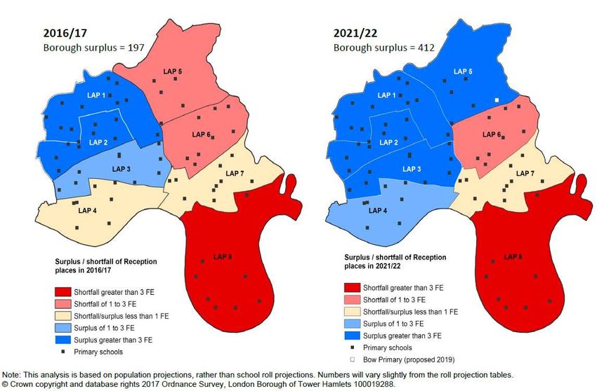
Appendix G: Secondary projections by LAP area
18Appendix A: School roll projection: Reception (January 2018)
Catchment 3 – Poplar
2015/16 2016/17 2017/18 2018/19 2019/20 2020/21 2021/22 2022/23 2023/24 2024/25 2025/26 2026/27 2027/28 2028/29 2029/30 2030/31
Actual 790 845
Projection (1 year) 845 865 820 836 821 858 874 892 910 922 940 949 962 973 986
Projection (3 year) 845 900 854 869 852 891 907 924 941 953 971 980 992 1,004 1,016
Capacity 885 885 885 885 885 885 885 885 885 885 885 885 885 886 887 888
Pupils 95 40 20 65 49 64 27 11 - 7 - 25 - 37 - 55 - 64 - 76 - 86 - 98
Variance (1 year)
FE 3.2 1.3 0.7 2.2 1.6 2.1 0.9 0.4 - 0.2 - 0.8 - 1.2 - 1.8 - 2.1 - 2.5 - 2.9 - 3.3
Pupils 95 40 - 15 31 16 33 - 6 - 22 - 39 - 56 - 68 - 86 - 95 - 106 - 117 - 128
Variance (3 year)
FE 3.2 1.3 - 0.5 1.0 0.5 1.1 - 0.2 - 0.7 - 1.3 - 1.9 - 2.3 - 2.9 - 3.2 - 3.5 - 3.9 - 4.3
Reception projections: Poplar (Catchment 3)
1,200
1,000
800
Capacity
600
Actual
400
Projection (1 year)
200 Projection (3 year)
-
2015/16
2016/17
2017/18
2018/19
2019/20
2020/21
2021/22
2022/23
2023/24
2024/25
2025/26
2026/27
2027/28
2028/29
2029/30
2030/31
Source: GLA School Roll Projections produced January 2018 (2016-based model, Local Plan + LLDC development trajectory, 1 year and 3 year back data
variants)
19Catchment 4 – Isle of Dogs
2015/16 2016/17 2017/18 2018/19 2019/20 2020/21 2021/22 2022/23 2023/24 2024/25 2025/26 2026/27 2027/28 2028/29 2029/30 2030/31
Actual 383 423
Projection (1 year) 423 414 387 395 410 427 455 483 511 539 566 583 600 611 621
Projection (3 year) 423 437 409 419 434 452 482 512 541 571 599 618 635 647 658
Capacity 425 425 425 425 425 425 425 425 425 425 425 425 425 426 427 428
Pupils 42 2 11 38 30 15 - 2 - 30 - 58 - 86 - 114 - 141 - 158 - 174 - 184 - 193
Variance (1 year)
FE 1.4 0.1 0.4 1.3 1.0 0.5 - 0.1 - 1.0 - 1.9 - 2.9 - 3.8 - 4.7 - 5.3 - 5.8 - 6.1 - 6.4
Pupils 42 2 - 12 16 6 - 9 - 27 - 57 - 87 - 116 - 146 - 174 - 193 - 209 - 220 - 230
Variance (3 year)
FE 1.4 0.1 - 0.4 0.5 0.2 - 0.3 - 0.9 - 1.9 - 2.9 - 3.9 - 4.9 - 5.8 - 6.4 - 7.0 - 7.3 - 7.7
Reception projections: Isle of Dogs (Catchment 4)
700
600
500
400 Capacity
300 Actual
200 Projection (1 year)
100 Projection (3 year)
-
2015/16
2016/17
2017/18
2018/19
2019/20
2020/21
2021/22
2022/23
2023/24
2024/25
2025/26
2026/27
2027/28
2028/29
2029/30
2030/31
Source: GLA School Roll Projections produced January 2018 (2016-based model, Local Plan + LLDC development trajectory, 1 year and 3 year back data
variants)
20All catchment areas (3 year variant)
2017/18 2018/19 2019/20 2020/21 2021/22 2022/23 2023/24 2024/25 2025/26 2026/27 2027/28 2028/29 2029/30 2030/31
Projections 3,690.0 3,451.0 3,492.0 3,456.0 3,480.0 3,515.0 3,553.0 3,589.0 3,610.0 3,645.0 3,674.0 3,706.0 3,727.0 3,758.0
Capacity 3,740.0 3,740.0 3,740.0 3,740.0 3,740.0 3,740.0 3,740.0 3,740.0 3,740.0 3,740.0 3,740.0 3,740.0 3,740.0 3,740.0
Borough
Surplus/Defecit Pupils 50.0 289.0 248.0 284.0 260.0 225.0 187.0 151.0 130.0 95.0 66.0 34.0 13.0 - 18.0
Surplus/Defecit FE 1.7 9.6 8.3 9.5 8.7 7.5 6.2 5.0 4.3 3.2 2.2 1.1 0.4 - 0.6
Projections 847.0 806.0 794.0 784.0 761.0 758.0 749.0 743.0 729.0 722.0 720.0 719.0 717.0 720.0
Capacity 840.0 840.0 840.0 840.0 840.0 840.0 840.0 840.0 840.0 840.0 840.0 841.0 842.0 843.0
Stepney
Surplus/Defecit Pupils - 7.0 34.0 46.0 56.0 79.0 82.0 91.0 97.0 111.0 118.0 120.0 122.0 125.0 123.0
Surplus/Defecit FE - 0.2 1.1 1.5 1.9 2.6 2.7 3.0 3.2 3.7 3.9 4.0 4.1 4.2 4.1
Projections 408.0 381.0 389.0 380.0 378.0 376.0 377.0 376.0 376.0 375.0 377.0 377.0 376.0 377.0
Capacity 450.0 450.0 450.0 450.0 450.0 450.0 450.0 450.0 450.0 450.0 450.0 451.0 452.0 453.0
Bow
Surplus/Defecit Pupils 42.0 69.0 61.0 70.0 72.0 74.0 73.0 74.0 74.0 75.0 73.0 74.0 76.0 76.0
Surplus/Defecit FE 1.4 2.3 2.0 2.3 2.4 2.5 2.4 2.5 2.5 2.5 2.4 2.5 2.5 2.5
Projections 900.0 854.0 869.0 852.0 891.0 907.0 924.0 941.0 953.0 971.0 980.0 992.0 1,004.0 1,016.0
Capacity 885.0 885.0 885.0 885.0 885.0 885.0 885.0 885.0 885.0 885.0 885.0 886.0 887.0 888.0
Poplar
Surplus/Defecit Pupils - 15.0 31.0 16.0 33.0 - 6.0 - 22.0 - 39.0 - 56.0 - 68.0 - 86.0 - 95.0 - 106.0 - 117.0 - 128.0
Surplus/Defecit FE - 0.5 1.0 0.5 1.1 - 0.2 - 0.7 - 1.3 - 1.9 - 2.3 - 2.9 - 3.2 - 3.5 - 3.9 - 4.3
Projections 437.0 409.0 419.0 434.0 452.0 482.0 512.0 541.0 571.0 599.0 618.0 635.0 647.0 658.0
Capacity 425.0 425.0 425.0 425.0 425.0 425.0 425.0 425.0 425.0 425.0 425.0 426.0 427.0 428.0
Isle of Dogs
Surplus/Defecit Pupils - 12.0 16.0 6.0 - 9.0 - 27.0 - 57.0 - 87.0 - 116.0 - 146.0 - 174.0 - 193.0 - 209.0 - 220.0 - 230.0
Surplus/Defecit FE - 0.4 0.5 0.2 - 0.3 - 0.9 - 1.9 - 2.9 - 3.9 - 4.9 - 5.8 - 6.4 - 7.0 - 7.3 - 7.7
Projections 484.0 429.0 442.0 437.0 439.0 439.0 440.0 440.0 439.0 438.0 438.0 439.0 438.0 439.0
Capacity 480.0 480.0 480.0 480.0 480.0 480.0 480.0 480.0 480.0 480.0 480.0 481.0 482.0 483.0
Wapping
Surplus/Defecit Pupils - 4.0 51.0 38.0 43.0 41.0 41.0 40.0 40.0 41.0 42.0 42.0 42.0 44.0 44.0
Surplus/Defecit FE - 0.1 1.7 1.3 1.4 1.4 1.4 1.3 1.3 1.4 1.4 1.4 1.4 1.5 1.5
Projections 613.0 572.0 579.0 568.0 558.0 554.0 550.0 548.0 542.0 540.0 541.0 544.0 545.0 548.0
Bethnal Capacity 660.0 660.0 660.0 660.0 660.0 660.0 660.0 660.0 660.0 660.0 660.0 661.0 662.0 663.0
Green Surplus/Defecit Pupils 47.0 88.0 81.0 92.0 102.0 106.0 110.0 112.0 118.0 120.0 119.0 117.0 117.0 115.0
Surplus/Defecit FE 1.6 2.9 2.7 3.1 3.4 3.5 3.7 3.7 3.9 4.0 4.0 3.9 3.9 3.8
Source: GLA School Roll Projections produced January 2018 (2016-based model, Local Plan + LLDC development trajectory, 1 year and 3 year back data
variants)
21Appendix B: Free schools in Tower Hamlets
In addition to the LA’s proposals for additional capacity, free schools agreed by the Secretary
of State contribute to the local supply of places. Free school proposers can apply direct to
the Secretary of State who decide on the schools to be agreed. Creation of additional
capacity outside the Council’s control adds to the difficulties of planning.
Status
School
Opened in September 2011, 40 places per year
Canary Wharf College, East Ferry
(primary)
Road
Opened in September 2012, 81 places per year
Wapping High School,
(secondary)
Commercial Road
Opened in September 2012, 50 places per year, now
Solebay Primary School, Solebay
operates at 60 places per year.
Street
City Gateway Opened in September 2012, 14-19 provision
Opened in September 2014, 40 places per year
Canary Wharf College 2
(primary). Occupying temporary accommodation.
Permanent site in Glenworth Road, E14 in development.
Opened in September 2014, 11-16 school with 120
London Enterprise Academy,
places per year.
Commercial Road
Opened in September 2014 in temporary
East London Academy of Music
accommodation in E15, 16-19 with up to 300
places. Now moved to new permanent accommodation
in Maltings Close, E3.
14-19 provision, specialising in healthcare and
Mulberry UTC (University Training
medical services, and digital technology.
College)
Approved for opening September 2015 but deferred to
Canary Wharf College 3
September 2016. Originally approved as an all-through
Christian faith school with 1330 places, opened in
temporary accommodation for secondary only with 40
Year 7 places for September 2016.
Permanent accommodation and planned capacity to be
confirmed.
Approved for opening in September 2019. All - through,
Livingstone Academy East London
mixed, non-faith school with 1,570 places, specialising in
computing and sciences. Proposed location at the
former LMU site in Aldgate, subject to planning consent.
LBTH has stressed to the DfE that there is no need for
primary places in this area of the borough.
Approved in September 2016 for pre-opening stage. No
Mulberry Boys’ School
identified site or proposed opening date.
Approved in April 2017 for pre-opening stage. No
Mulberry Primary School
identified site or proposed opening date. If located near
22to the existing Mulberry School for Girls, this will be in
an area where LBTH has not identified a need for places,
as above for Livingstone Academy.
23Appendix C : Projects identified to help meet the need for primary schools
Project Ward Description Council Estimate CIL/S106 Planned Comments
Reference run/ d Cost Funding Year of
owned required? delivery
Former Bow Bow East Redevelopment to
Boys' School provide 3FE (2 FE No – fully
£15m 2019/20
Special Education funded
Facility)
Sweetwater Bow East Redevelopment to Primary school. Originally 3FE school proposed in
School provide 2FE Legacy masterplan with a new secondary school
elsewhere in the area. It is now proposed to open
an all-through school, the
Bobby Moore Academy, from September 2018.
The school will have 1,560 pupils in total with 60
places for Reception and 180 for Year 7.
Although the primary site is in Tower Hamlets, the
No – fully secondary site is in LB Newham and is the
TBC 2018/19
funded principal address of the school. The school is
formally in LB Newham and is not now shown as
proposed capacity in LBTH although accessible to
Tower Hamlets residents. The impact of this
primary provision on the pattern of applications to
Tower Hamlets schools will be monitored from
September 2018, to assess whether it causes a
significant reduction in demand for in-borough
provision.
Neptune Bow East Redevelopment to Site allocation for a primary school at Neptune
TBC TBC TBC
Wharf (LLDC) provide 2FE Wharf. Planning application approved by LLDC in
24Project Ward Description Council Estimate CIL/S106 Planned Comments
Reference run/ d Cost Funding Year of
owned required? delivery
March 2014 includes outline permission for a 3FE
school. The s. 106 requires LBTH to
develop a school specification and design within 2
years of start on site in summer 2015 and
exercise the option to develop within 5 years of
this date.
Wood Wharf Blackwall Provision of a 2FE 2FE primary school included in the proposals (s.106
and Primary School as Land/ agreement December 2014). LBTH has worked with
Cubitt part of a mixed use shell and CWG on detailed planning application. Cabinet on
Town development core 31 October will be asked to agree to enter into an
being Yes – Agreement for Lease and approve a capital
delivered allocation allocation to fit out the shell and core building
under of £3m to 2021/22 provided by CWG.
S106. cover fit- Commitment to this scheme is required earlier than
Cost of fit out costs might be the case for a scheme constructed wholly
out, by LBTH in order to give comfort to CWG
estimated to allow them to commence enabling works in
£5m January 2018. Anticipated school opening date
September 2022.
50 Marsh Wall Canary Provision of a 2FE Land/ Yes – Planning application determined by Mayor of
(Alpha Square Wharf Primary School as shell and through ‘in- London. 2FE primary school included in the
Development) part of a mixed use core: kind scheme. Details of how this will operate and
development £8,938,70 agreement’ anticipated opening date tbc.
TBC
3 for
provision of
Fit out: land and
TBC – shell and
25Project Ward Description Council Estimate CIL/S106 Planned Comments
Reference run/ d Cost Funding Year of
owned required? delivery
estimate core
£6m
3 Millharbour Canary Provision of a 2FE Land/ 2FE primary school included in the proposals.
Yes –
Wharf Primary School as shell and Planning consent issued. Land and development
through ‘in-
part of a mixed use core: agreement completed. Anticipated school opening
kind
development £6,101,56 2023.
agreement’
0
for 2022/23
provision of
Fit out:
land and
TBC –
shell and
estimate
core
£6m
Site Allocation Lansbury Redevelopment to
– Ailsa Street provide 2FE
(Former £10.2m Yes TBC
Bromley Hall
School)
Site Allocation Canary Site Allocation – 2 TBC
– Marsh Wall Wharf FE Estimate:
East £13m Yes TBC
(£6.5m
per FE)
Site Allocation Canary Site Allocation – 2 TBC
– Millharbour Wharf FE Estimate:
South £13m Yes TBC
(£6.5m
per FE)
26Project Ward Description Council Estimate CIL/S106 Planned Comments
Reference run/ d Cost Funding Year of
owned required? delivery
Site Allocation Blackwall Site Allocation – 2 TBC
– and FE Estimate:
Crossharbour Cubitt £13m Yes TBC
Town Centre Town (£6.5m
per FE)
Site Allocation Blackwall Proposed Site TBC
– Reuters and Allocation – 2 FE Estimate:
Cubitt £13m Yes TBC
Town (£6.5m
per FE)
Site Allocation Blackwall Proposed Site TBC
– Limeharbour and Allocation – 2 FE Estimate:
Cubitt £13m Yes TBC
Town (£6.5m
per FE)
Total £123.24m
27Appendix D: Reception projections by LAP area
(Source: Planning for School Place – 2017/2018 Review)
28Appendix E: School roll projections: Secondary (January 2018)
2012/13 2013/14 2014/15 2015/16 2016/17 2017/18 2018/19 2019/20 2020/21 2021/22 2022/23 2023/24 2024/25 2025/26 2026/27 2027/28 2028/29 2029/30 2030/31
Actual 2,932 2,839
Projection (1 year) 2,839 3,166 3,179 3,269 3,340 3,495 3,584 3,741 3,696 3,499 3,519 3,507 3,523 3,551 3,582
Projection (3 year) 2,839 3,241 3,258 3,350 3,428 3,589 3,680 3,841 3,794 3,592 3,615 3,603 3,621 3,650 3,682
Capacity 2,816 2,816 3,081 3,081 3,152 3,152 3,152 3,152 3,152 3,152 3,152 3,152 3,152 3,152 3,152 3,241 3,259 3,277 3,294
Pupils 2,816 2,816 3,081 149 313 - 14 - 27 - 117 - 188 - 343 - 432 - 589 - 544 - 347 - 367 - 266 - 264 - 274 - 288
Variance (1 year)
FE 93.9 93.9 102.7 5.0 10.4 - 0.5 - 0.9 - 3.9 - 6.3 - 11.4 - 14.4 - 19.6 - 18.1 - 11.6 - 12.2 - 8.9 - 8.8 - 9.1 - 9.6
Pupils 2,816 2,816 3,081 149 313 - 89 - 106 - 198 - 276 - 437 - 528 - 689 - 642 - 440 - 463 - 362 - 362 - 373 - 388
Variance (3 year)
FE 93.9 93.9 102.7 5.0 10.4 - 3.0 - 3.5 - 6.6 - 9.2 - 14.6 - 17.6 - 23.0 - 21.4 - 14.7 - 15.4 - 12.1 - 12.1 - 12.4 - 12.9
Year 7 projections: borough
4,500
4,000
3,500
3,000
2,500 Capacity
2,000 Actual
1,500
Projection (1 year)
1,000
500 Projection (3 year)
-
Source: GLA School Roll Projections produced January 2018 (2016-based model, Local Plan + LLDC development trajectory, 1 year and 3 year back data
variants)
29Appendix F: Projects identified to help meet the need for secondary schools
Project Reference Ward Description Est. Cost CIL/S106 Planned Comment
Funding Year of
required? delivery
Site allocation in the adopted
Managing Development Document
and the emerging Local Plan for a 6FE
secondary school. Planning application
approved March 2014 includes outline
Site Allocation – Site allocation for 6FE
St Katharine’s & permission for a school. LBTH has 10
London Dock site secondary school. LBTH to Yes (£25m
Wapping. Meets £45m 2020/21 year period to exercise the option to
(School secured in take a long lease and fund CIL)
borough-wide need. develop the school. The design and
permission) construction of new school.
programme are in development and
could be the subject of a decision to
proceed as early as October 2017 with
a projected opening date of
September 2020.
Site allocation for a 6FE secondary
school. Planning application
determined by Mayor of London
includes site for the school. Section
Site Allocation –
106 agreement completed which
Westferry Printworks Canary Wharf. Meets Site allocation for 6FE
£45m Yes TBC allows LBTH to take a lease and
site (School secured borough-wide need. secondary school.
develop the school site or to agree
in permission)
that the DfE should develop it for a
free school. Liaison with the DfE over
the development of this site has
generated discussion of potential
30Project Reference Ward Description Est. Cost CIL/S106 Planned Comment
Funding Year of
required? delivery
routes for determining the provider of
the
education service, which would have
implications for delivery of the
accommodation and funding of the
capital cost of the scheme.
Lansbury. Meets Additional accommodation
Langdon Park School £5m Yes 2019
borough-wide need. for 6th form.
George Green’s Island Gardens. Meets Additional accommodation
£5m Yes 2019
School borough-wide need. for 6th form.
Whitechapel. Meets
Livingstone Academy 4 FE Academy. N/A N/A 2017
borough-wide need.
Canary Wharf
Site Allocation – Site allocation for 6FE
Meets borough-wide £39m Yes TBC
Billingsgate Market secondary school.
need.
Site Allocation – Poplar
Site Allocation for 6FE
Leven Road Gas Meets borough-wide £39m Yes TBC
secondary school.
Works need.
The viability report concludes that the
Blackwall and Cubitt
site is not viable as it will only be able
Site Allocation – Bow Town Site allocation for 6FE
£39m Yes TBC to deliver 5% affordable housing if the
Common Gas Works Meets borough-wide secondary school.
open space and secondary school are
need.
provided.
31Project Reference Ward Description Est. Cost CIL/S106 Planned Comment
Funding Year of
required? delivery
The site is situated within the Central
sub-area which is not identified as an
area of high growth
Refurbishment: Provision Yes, £4m
Raine’s Foundation
Bethnal Green of new Gym and Library £5.2m S106 2017/18
School
facilities. allocated.
Total £222.2m
32Appendix G : Secondary projections by LAP area
(Source: Planning for School Place – 2017/2018 Review)
33You can also read