Species Conservation and Consultation Guide
←
→
Page content transcription
If your browser does not render page correctly, please read the page content below

U.S. Fish & Wildlife Service

Species Conservation and
Consultation Guide
Sand Skink
Generated February 19, 2023 01:31 PM UTC, IPaC v6.88.0-rc2

IPaC - Information for Planning and Consultation (https://ipac.ecosphere.fws.gov/): A project planning tool to help streamline the
U.S. Fish and Wildlife Service environmental review process.
South Florida Ecological Services Field Office - Publication Date: August 12, 2020
Species Survey Guidelines - Sand Skink

                                                                                                        July 31, 2020

                                       Peninsular Florida
                           Species Conservation and Consultation Guide

                        Sand Skink and Blue-tailed (Bluetail) Mole Skink
This guide for sand skink (Plestiodon [Neoseps] reynoldsi) and blue-tailed mole skink
(Plestiodon [Eumeces] egregius lividus) conservation and Endangered Species Act (ESA)
consultation is intended to assist project proponents to determine if or how a proposed action
may affect sand skinks or blue-tailed mole skinks.

The sand skink and blue-tailed mole skink are listed as threatened pursuant to the ESA. The
ESA prohibits the unauthorized “take” a of threatened and endangered species. Individuals and
entities intending to conduct projects that may affect listed species may lawfully incidentally
take those species after consulting with the U.S. Fish and Wildlife Service (Service) pursuant to
section 7 or 10 of the ESA. When a project is conducted, funded, or authorized by a Federal
agency, listed species consultation occurs through section 7 of the ESA. When there is no
Federal nexus (e.g., Federal authorization or funding), a non-Federal entity who wishes to
conduct an activity may legally “take” listed species after obtaining an Incidental Take b Permit
(ITP) from the Service in accordance with section 10 of the ESA.

In this guide, we first summarize sand skink and blue-tailed mole skink status, life history,
distribution, habitat, and threats. Then we discuss the consultation steps, including: assessing the
effects of the proposed action, making effect determinations, and incorporating conservation
measures into proposed actions to maximize beneficial effects and to avoid or minimize negative
effects to listed skinks and their habitat. Appendix A provides a recommended skink survey
protocol, Appendix B provides a method for estimating skink habitat use based upon movement
data and survey results, Appendix C provides a variety of possible Conservation Measures,
including conservation, compensation, and mitigation guidance, and Appendix D provides a
Habitat Equivalency Analysis calculator. The current guide will be updated as new information
becomes available and will be posted on the Service’s South Florida website at
http://www.fws.gov/verobeach/.

For more information on sand skink and blue-tailed mole skink biology, habitat needs, threats,
taxonomy, and recovery criteria and goals, see the Bluetail Mole Skink and Sand Skink 5-Year

a
  “Take” is defined as harm, harass, pursue, hunt, shoot, wound, kill, trap, capture, collect, or to attempt to engage in
any such conduct. The term “harm” includes any act which actually kills or injures fish or wildlife, and emphasizes
that such acts may include significant habitat modification or degradation that significantly impairs essential
behavioral patterns of fish and wildlife. The term “harass” is defined as any act that creates the likelihood of injury
to listed species to such an extent as to significantly disrupt normal behavior patterns which include but may not be
limited to breeding, feeding, or sheltering.
b
 “Incidental Take” is defined as take that results from, but is not the purpose of, carrying out an otherwise lawful
activity.

    2/19/2023 1:31 PM                               IPaC v6.88.0-rc2                                             Page 1
South Florida Ecological Services Field Office - Publication Date: August 12, 2020
Species Survey Guidelines - Sand Skink

Peninsular Florida Species CCG for Skinks                                            July 31, 2020   2

Status Review (Service 2007) and the South Florida Multi-Species Recovery Plan (Service
1999). Published literature as well as unpublished reports, information, and data referenced in
the skink conservation and consultation guide are available at the Service’s South Florida
Ecological Services Office (SFESO) in Vero Beach, Florida (by phone at 772-562-3909 or by
mail at 1339 20th Street, Vero Beach, Florida 32960-3559).

Status

The Service listed the sand skink and the blue-tailed mole skink as threatened under the ESA in
1987 primarily due to modification and destruction of xeric upland communities in central
Florida. Habitat loss, habitat fragmentation, and changes in land use still threaten sand skinks
and blue-tailed mole skinks. In addition, lack of habitat management, competition from non-
native and invasive plant species, and loss of genetic diversity threaten sand skink and blue-
tailed mole skink existence (Service 1999; 2007).

Life History

Little is known about sand skink and blue-tailed mole skink population or reproduction ecology.
Both sand skinks and blue-tailed mole skinks are difficult to detect and study due to their small
size and semi-fossorial to fossorial habits. Sand skinks and blue-tailed mole skinks generally
partition rather than compete with one another for resources. Sand skinks are primarily fossorial;
they move or “swim” below the surface of the ground in sandy soils and take prey below the
surface. Blue-tailed mole skinks are semi-fossorial; they hunt at the soil surface and consume
mostly terrestrial arthropods (Smith 1977).

No data are available on sand skink or blue-tailed mole skink home ranges, or blue-tailed mole
skink dispersal. Information on sand skink dispersal and movement patterns is limited. Sand
skink studies in the early 2000s documented several instances where movement distances
exceeded 460 feet (ft) (140 meters [m]) (Mushinsky et al. 2001; Penney 2001; Penney et al.
2001) and one instance where an adult male moved over 780 ft (240 m) (Penney 2001). Other
studies suggested that some individual sand skinks may move more than 3,280 ft (1 kilometer
[km]) and up to 26,250 ft (8 km) where suitable soils are contiguous with no natural or manmade
barriers to movement, but some data points in this dataset could not be verified (Mushinsky et al.
2011). Schrey et al. (2011) conducted a genetic analysis of sand skinks (n = 470) within 25 m of
each other, and reported "the Florida sand skink occurs with higher genetic similarity than
expected by chance within 25 m (82 ft)". Although dispersal data are not available for blue-
tailed mole skinks, Schrey et al. (2012) found no genetic evidence of long-distance dispersal.
Penney (2001) reported translocated sand skinks moved a median distance of 25.6 m (84 ft; n =
64). Perry and Garland (2002) reviewed literature and examined home range as a function of
snout-vent length in lizards. Of the 489 data sets they examined, 108 met their criteria for their
analysis. Lizards of the Autarchoglossa (the clade that contains all skink species) with snout-
vent lengths ranging from 30 millimeters (mm) to 100 mm (i.e., the range representative of sand
skinks) had home ranges of approximately 10 m2 to approximately 1,700 m2. A 1,700 m2 area
has a radius of 23 m (75 ft). After reviewing this information, the Service has determined that
sand skinks are reasonably certain to feed, breed, and shelter within 80 ft of a track when the

2/19/2023 1:31 PM                                 IPaC v6.88.0-rc2                            Page 2

South Florida Ecological Services Field Office - Publication Date: August 12, 2020
Species Survey Guidelines - Sand Skink

Peninsular Florida Species CCG for Skinks                                            July 31, 2020     3

habitat is suitable. Currently, a multi-year study on home range sizes and/or movement distance
is being conducted. If additional scientific information is obtained, data will be evaluated and
changes to these guidelines may be necessary at that time.

Distribution

Reptile research and incidental observations to date indicate blue-tailed mole skinks typically
occur with sand skinks. Only sand skinks leave visible signs, or tracks, on sandy soil surfaces.
Therefore, sand skink occurrence is used as an indicator of blue-tailed mole skink occurrence
where the two species overlap in distribution. Blue-tailed mole skink genetic studies indicate
that conservation actions for sand skinks will also likely benefit blue-tailed mole skinks (Schrey
et al. 2012).

Both sand skinks and blue-tailed mole skinks are endemic to, which means they occur only on,
the sandy ridges of central Florida. Skink distribution is defined by three factors: county,
elevation, and soil types. Primary populations of sand skinks occur on the Lake Wales, Winter
Haven, and Mt. Dora Ridges in Highlands, Lake, Marion, Orange, Osceola, Polk, and Putnam
Counties. Blue-tailed mole skinks are restricted to the Lake Wales Ridge in Highlands, Polk,
and Osceola Counties.

Skinks are generally found at elevations 82 ft above sea level and higher (Florida Natural Areas
Inventory 2007). Recent skink occurrences documented at 70 ft above sea level indicate skinks
occur at lower elevations where suitable soil conditions for skinks continue down slope (Service
unpubl. data).

Skinks occur in excessively drained, well-drained, and moderately well-drained sandy soils that
include the Apopka, Arredondo, Archbold, Astatula, Basinger, Candler, Daytona, Duette,
Florahome, Gainesville, Hague, Immokalee, Kendrick, Lake, Millhopper, Orsino, Paola, Placid,
Pomello, Pompano, Satellite, Samsula, Smyrna, St. Lucie, Urban land (when open sandy soils
persist and remnant scrub remains), Tavares, Zolfo and Zuber soil series, referred to as “skink
soils” in this guide. Soil series maps are available online
(https://sdmdataaccess.nrcs.usda.gov/and through county extension offices.

Habitat

Skink habitat identified in this guide includes skink soils at and above 82 ft above sea level.
Skink searches or surveys following a standardized protocol (Appendix A) should be conducted
in all skink soils above 82 ft elevation or in projects areas that are directly adjacent to suitable
habitat. Additional skink surveys, monitoring, and observations will likely improve knowledge
of skink occurrence and distribution, as well as understanding of skink habitat use.

Skink soils typically support scrub, sandhill, or xeric hammock natural ecological communities,
such as oak-dominated scrub, turkey oak (Quercus laevis) barrens, high pine, and xeric
hammocks. Typical upland habitat for both sand skinks and blue-tailed mole skinks consists of
sand pine (Pinus clausa)-rosemary (Ceratiola ericoides) scrub or longleaf pine (Pinus palustris)-

2/19/2023 1:31 PM                                 IPaC v6.88.0-rc2                            Page 3
South Florida Ecological Services Field Office - Publication Date: August 12, 2020
Species Survey Guidelines - Sand Skink

Peninsular Florida Species CCG for Skinks                                            July 31, 2020   4

turkey oak/sand live oak (Quercus geminate) association. Sand skinks have also been
documented in skink soils where natural vegetative cover has been altered for human uses such
as pine plantations, active or inactive citrus groves, pastures, and residential developments, as
well as neglected vegetative cover like old fields and overgrown scrub, especially in areas with
overgrown or remnant scrub adjacent (Pike et al. 2008). Blue-tailed mole skinks occur in habitat
similar to that used by sand skinks. Habitat condition or vegetative cover alone cannot be used
to exclude areas that might be used by sand skinks or blue-tailed mole skinks.

Both sand skinks and blue-tailed mole skinks typically occur in areas that contain a mosaic of
open sandy patches interspersed with forbs, shrubs, and trees. Sand skink tracks are usually
observed in open sandy areas, yet both skink species use a variety of micro-habitats within xeric
vegetative communities. Sand skink tracks appear most abundant in the ecotone, or edges,
between areas with abundant leaf litter and vegetative cover and adjacent open sands. Blue-
tailed mole skinks are typically found under leaf litter, logs, palmetto fronds, and other ground
debris (Christman 1992).

Specific physical structures of habitat that sustain sand skink populations, and likely blue-tailed
mole skink populations as well, include a well-defined leaf litter layer on the ground surface and
shade from either a tree canopy or a shrub layer, but not both. Leaf litter likely provides
important skink foraging opportunities. Shade provided by a tree canopy or a shrub layer likely
helps skinks regulate body temperature to prevent overheating. However, having both a tree
canopy and a shrub layer appears to be detrimental to skinks (McCoy 2011, University of South
Florida, pers. comm.).

Either natural fires started by lightning or prescribed burns are necessary to maintain habitat in
natural scrub ecosystems. However, if fire occurs too frequently, leaf litter might not build up
sufficiently to support skink populations. At Archbold Biological Station, sand skinks appear to
be most abundant after 10 years of leaf litter development. The ideal fire frequency to maintain
optimal leaf litter development for skinks likely varies by site and other environmental
conditions (Mushinsky 2011, University of South Florida, pers. comm.).

Threats

Habitat loss, fragmentation, and changes in land use continue to threaten sand skinks and blue-
tailed mole skinks. Development and agricultural conversion have resulted in the loss of
approximately 85 percent of the scrub and sandhill habitats on the Lake Wales Ridge (Turner et
al. 2006). Habitat degradation and fragmentation also continue to affect populations, even on
protected lands. Active management is necessary to maintain suitable habitat for skinks. Much
of the remaining habitat occurs in small, isolated patches surrounded by residential areas or
citrus groves, making the suitable habitat patches and connections between patches difficult to
protect and manage. Many habitat patches are overgrown and in need of restoration, but
vegetation restoration and management programs are costly and depend upon availability of
funding. Privately-owned sites remain at risk of being developed, and destruction or habitat
modification due to improper or lack of management remains a concern. Conversion of rural
lands to urban use in central Florida where skinks occur is projected to continue over the next 50

2/19/2023 1:31 PM                                 IPaC v6.88.0-rc2                            Page 4
South Florida Ecological Services Field Office - Publication Date: August 12, 2020
Species Survey Guidelines - Sand Skink

Peninsular Florida Species CCG for Skinks                                             July 31, 2020     5

years. In addition, fire suppression, improper stand management, competition from invasive
plant species, and loss of genetic diversity continue to threaten the existence of the sand skink
and blue-tailed mole skink.

Critical Habitat

Critical habitat has not been designated for either sand skinks or blue-tailed mole skinks.

Consultation Area

The Service delineated a consultation area (Figure 1 and Figure 2) to assist project proponents to
determine if a proposed action might affect sand skinks or blue-tailed mole skinks (skinks). The
consultation area is intended to guide project proponents of both Federal and non-Federal
actions. Some locations inside the consultation area may not contain appropriate soils and
elevation to support skinks. The consultation area includes: (1) known skink locations, (2) skink
soils at appropriate elevations defined as skink habitat, and (3) natural and developed ecosystems
that are known to support skinks. Experts cannot determine the location of each skink
throughout the year, or the exact areas that support skink feeding, breeding, and sheltering, even
if extensive continuous year-long research is conducted in central Florida. Therefore, the
consultation area outlines a geographic landscape with a higher likelihood of skink habitat use
than the landscape outside of the consultation area.

In general, proposed actions inside the consultation area are more likely to affect skinks, and
proposed actions outside the consultation area are less likely to affect skinks. Though the
consultation area provides an initial analysis tool, users evaluating a proposed action should not
consider the consultation area as the only factor in deciding whether or not consultation is
required. The consultation area is based on best available information to date. We expect that
more information will improve and refine our knowledge of skink occurrence in the future.
Consultation is required if proposed actions outside the delineated consultation area may affect
skinks. Similarly, consultation may not be required if proposed actions inside the consultation
area will not affect skinks (e.g., if the project location is not within the appropriate elevation or
does not contain suitable skink soils).

Consultation

Federal and non-Federal project proponents have different responsibilities for conducting
consultations to ensure compliance with the ESA. This section outlines a stepwise process to
guide consultation for skinks. All project proponents should follow Steps 1 and 2 regardless of
whether they are consulting on Federal actions through section 7 or seeking technical assistance
through section 10. Federal project proponents should continue with Steps 3 and 4. Non-Federal
project proponents seeking incidental take authorization through section 10 of the ESA should
contact the Service at 772-562-3909 in South Florida or 904-731-3336 in North Florida for
additional information.

2/19/2023 1:31 PM                                 IPaC v6.88.0-rc2                             Page 5
South Florida Ecological Services Field Office - Publication Date: August 12, 2020
Species Survey Guidelines - Sand Skink

Peninsular Florida Species CCG for Skinks                                            July 31, 2020   6

Federal Action Agencies

In addition to this guide, the ESA section 7 Consultation Handbook (Services 1998), and the
Service’s consultation checklist provide information on consultation for Federal actions. The
Guide to a Complete Initiation Package (Service 2004b) and checklist provide details on how to
prepare a complete consultation initiation package.

Non-Federal Entities

When an action, such as clearing vegetation, conducting development activities, or permitting of
such activities, is proposed within the Skink Consultation Area and there is no Federal nexus, we
recommend that non-Federal entities (i.e.; private land owners; businesses; state, county, or local
municipalities) request technical assistance from the Service under section 10 of the ESA prior to
initiating or authorizing the proposed activity. The Service will review the information provided
to assess if the action has the potential to result in take of skinks or other listed animal or plant
species. If the proposed action is likely to take listed species, the Service recommends that the
non-Federal entity apply for an Incidental Take Permit (ITP) to ensure compliance with the ESA
and to minimize the risk of third party lawsuits. As part of the ITP application, applicants
develop a Habitat Conservation Plan (HCP). Among other things, the HCP describes the actions
that the applicant will implement to minimize and mitigate negative effects to listed species,
demonstrates that there will be no appreciable reduction in the survival of the species, and
demonstrates that there is adequate funding and other assurances to ensure the plan will be fully
implemented. For more information, contact the Service at 772-562-3909 in South Florida or
904-731-3336 in North Florida. Additional information on section 10 consultation can be found
on the Service’s national website (http://www.fws.gov/endangered/what-we-do/hcp-
overview.html) and the South Florida Ecological Services (SFESO) website
(http://www.fws.gov/verobeach/).

Step 1: Describe the Proposed Action

Fully describe all features and activities related to the proposed action, such as: proposed project
purpose; all aspects of proposed construction, including road access, staging areas, and any
associated land clearing and filling; information on surveys and monitoring; and anticipated post-
project operations, maintenance, and management. Describe the project location, habitat, soil
types, and elevations affected. Develop and provide maps of all project locations, boundaries,
county lines, soil types, elevation, and habitat. On the maps, delineate project boundaries, map
suitable soils and elevations, and quantify the acreage of proposed impact. On the maps, also
designate those areas that are not considered habitat (e.g., existing paved surfaces, water bodies,
existing structures, etc.).

Consequences of the action should be considered. Consequences are a result or effect of an
action, and we apply the two-part test to determine whether a given consequence should be
considered an effect of the proposed action that is under consultation. An example is
constructing a road to access a proposed action site. The access road would not be necessary but
for the proposed action. Interdependent activities have no independent utility apart from the

2/19/2023 1:31 PM                                 IPaC v6.88.0-rc2                            Page 6
South Florida Ecological Services Field Office - Publication Date: August 12, 2020
Species Survey Guidelines - Sand Skink

Peninsular Florida Species CCG for Skinks                                            July 31, 2020   7

proposed action. An example is annual maintenance of the access road. Maintenance would not
be necessary but for continued need for access to the proposed action.

More information on complete proposed action descriptions can be found in the Species
Conservation Guidance Introduction of this document. Early coordination with the Service can
reduce requests for additional information and reduce consultation time frames.

Step 2: Determine and Describe Species, Habitat, or Critical Habitat that May Be Affected.
Note: Because no critical habitat has been designated for skinks, it will not be addressed further
in this guidance.

    2a: Species Location by County. Check to determine if the proposed action is in a county
        where skinks occur. Skink habitat typically supports federally listed plants and other
        species that should be consulted on, as well (See Figure 1 or the Service’s website at
        http://ecos.fws.gov/ipac/).

    2b: Consultation Area. If the proposed action is in a county where skinks generally occur,
        check the skink consultation area map (Figure 1 and Figure 2) to see if the proposed
        action is in or close to the delineated consultation area. Keep in mind that a proposed
        action may affect skinks whether or not it is within the consultation area boundary (e.g.,
        where skink soils are found or skinks or skink sign are detected outside of the
        boundary). Additional analysis may be needed.

    2c: Species Occurrence by Habitat. If the proposed action is in the consultation area or
        otherwise might affect skinks, determine if skink habitat may be affected. Potential
        skink habitat includes all areas with skink soils (Refer to Distribution). Skink habitat
        consists of natural xeric vegetative cover and areas altered for human uses, including but
        not limited to: pine plantations, active or inactive citrus groves, pastures, residential
        developments, and neglected vegetative cover like old fields and overgrown scrub.

         Check the natural community maps to determine if the proposed action is in or might
         affect natural ecological communities that traditionally indicated skink habitat. Because
         of the cumulative conversion of natural xeric communities for human uses, remaining
         natural xeric scrub is particularly important to maintain and support remaining skink
         populations.

         This concludes the desktop analysis of the proposed action. However, site-specific
         assessments of parcels proposed for modification are necessary to determine if the
         proposed action may affect skink habitat.

    2d: Early coordination. The Service highly recommends that applicants and their
        representatives contact the Service early in the planning process to determine if surveys
        are recommended or if methodology is sufficient to detect presence. Early coordination
        will also assist in determining mitigation or minimization needs at the beginning of the
        consultation process.

2/19/2023 1:31 PM                                 IPaC v6.88.0-rc2                            Page 7
South Florida Ecological Services Field Office - Publication Date: August 12, 2020
Species Survey Guidelines - Sand Skink
Peninsular Florida Species CCG for Skinks July 31, 2020 8
In situations where projects meet soil, elevation, and habitat criteria, the Service
recommends surveying the project site to indicate whether skinks occur within the
project area, or if present, what extent of the project area they are utilizing. Prior to
coverboard surveys, pedestrian surveys may be used to detect skink presence. However,
pedestrian surveys may not be used to determine absence. See Appendix A for the
Service’s recommended survey protocol. Survey procedures should be followed closely
and surveyors should have qualifications that include prior skink survey experience to
increase the probability of detecting listed skinks where they occur. As stated in the
protocol, the Service strongly recommends that project proponents contact us prior to
initiating surveys.
If skinks are confirmed to occur within all or part of a proposed action area, whether
inside or outside of the consultation area (Figure 1 and Figure 2), the site where skinks
occur is considered occupied where habitat is suitable. The proposed action must be
evaluated to determine if it may affect skinks.
The risk of a proposed action affecting occupied skink habitat does not depend solely on
whether or not the action is located within known occupied skink habitat. Additional
analysis (as described in Step 3a-b below) is needed to determine if project activities
might affect skinks. A project may be so benign as to not affect skinks. If an analysis
indicates a project presents only insignificant (small in size) or discountable (extremely
unlikely to occur) negative risks to skinks, the applicant may consider incorporating
conservation measures (see Step 3c and Appendix C), as appropriate, into the project
design to further avoid or minimize direct or indirect negative effects to skinks. If a
project will adversely affect skinks, it may be necessary to incorporate compensation or
mitigation into the project design (Appendix C) to help offset anticipated incidental take.
Contact the Service or other sources early in the project planning and development
process for more information on skinks and their habitat that may be affected by a
proposed action.
Step 3: Evaluate Effects of the Proposed Action and Incorporate Conservation Measures.
3a: Describe potential effects of the proposed action, as well as consequences of the action,
which may affect skinks. Proposed actions that would alter sites occupied by skinks
could potentially affect skinks (e.g., ground-disturbing or soil-compacting activities;
clearing; construction, access, and staging activities; operation and maintenance
activities; chemical applications; etc.)(Figure 1 and Figure 2).
3b: Describe potential cumulative effects which are the effects of future State or private
activities, not involving Federal activities, which are reasonably certain to occur within
the action area of the Federal action subject to consultation. These include effects that
result in abiotic disturbances like chemical, radiation, or temperature changes and biotic
disturbances like water quality, soil condition, vegetation cover, or topographic changes.
2/19/2023 1:31 PM IPaC v6.88.0-rc2 Page 8South Florida Ecological Services Field Office - Publication Date: August 12, 2020
Species Survey Guidelines - Sand Skink
Peninsular Florida Species CCG for Skinks July 31, 2020 9
3c: Describe conservation measures incorporated into the project plan to avoid or minimize
negative effects, in particular avoidance or minimization of adverse effects to skinks or
their habitat. Describe conservation measures applied to compensate for anticipated
incidental take. See more on Conservation Measures in Appendix C.
Contact the Service early in the consultation process for assistance in evaluating effects
of the proposed action on skinks.
Step 4: Document methods, evidence, analyses, and reasoning and make a determination;
prepare and submit a complete consultation initiation package that includes:
4a. A complete description of the proposed action.
4b. A complete description of federally listed resources (listed species and, if applicable,
designated critical habitats) that may be affected.
4c. A complete description of potential direct (caused by the action, likely to affect listed
resources, reasonably certain to occur), indirect (similar to direct effects but occur later
in time), and cumulative (non-Federal actions reasonably certain to occur in the action
area) effects and conservation measures incorporated to avoid, minimize, or compensate
for adverse effects. Provide a complete description of conservation measures applied to
avoid, minimize, or compensate for adverse effects anticipated to result in incidental
take. Adverse effects may be either permanent or temporary in nature. See Appendix C
for guidance on how to determine the nature of the adverse effects and calculate
compensation for each.
4d. Reasoning or logic statements that connect the proposed action, affected listed resources,
potential effects, and conservation measures; the reasoning should provide logical
support and justification for the effect determinations.
4e. (An) effect determination(s), or a conclusion(s), and further coordination with the
Service. Three effect determinations are possible:
i. “No effect” - If the proposed action is 1) outside the consultation area and contains no
suitable habitat, or 2) inside the consultation area but contains no suitable habitat, then
the action will not affect skinks, and the proposed action determination should be “no
effect.”
ii. “May affect, not likely to adversely affect” - If the proposed action is in the
consultation area and contains suitable habitat, elevation, and soils, the Service
recommends proceeding with surveys within the project area (see Step 2). If skinks or
their sign are detected and the proposed action will have only beneficial, insignificant, or
discountable effects on skinks, the proposed action determination should be “may affect,
not likely to adversely affect.” The Service will concur with this determination unless
2/19/2023 1:31 PM IPaC v6.88.0-rc2 Page 9South Florida Ecological Services Field Office - Publication Date: August 12, 2020
Species Survey Guidelines - Sand Skink
Peninsular Florida Species CCG for Skinks July 31, 2020 10
survey protocols were not followed. Clearly document your survey methods and results,
effects analyses, and reasoning so that we can evaluate your findings to prepare the
Service’s written concurrence, which is required for a “may affect, not likely to
adversely affect” determination.
iii. “May affect, likely to adversely affect” – If sand skinks or their sign have been
detected within the project area and if all avoidance and minimization measures have
been incorporated into the design of your project and the remaining adverse effects to
skinks are not insignificant or discountable, the determination for the proposed project
should be “may affect, likely to adversely affect” skinks. This is true if skinks have been
documented to occur, are detected, whether or not the proposed action is within or
outside of the consultation area. Formal consultation with the Service is required. The
Service may be contacted early for technical assistance to help identify additional
conservation measures to minimize adverse effects to skinks. For guidance on when to
seek an incidental take permit, see memo 067674.
Reinitiation of Consultation
While the issuance of the Service’s biological opinion or concurrence letter concludes
consultation, reinitiation of consultation is required if: (1) the amount or extent of incidental take
is exceeded; (2) new information reveals the action may affect listed species or critical habitat in
a manner or to an extent not considered; (3) the action is modified which causes an effect not
previously considered; or (4) a new species is listed or critical habitat designated that may be
affected by the action. Any operation causing incidental take which exceeds the amount or
extent anticipated must cease, and the Service must be contacted immediately.
Literature Cited
Christman, S.P. 1992. Bluetail mole skink. Pages 117-122 in P.E. Moler, editor. Rare and
Endangered Biota of Florida. Vol. 3. Amphibians and Reptiles. University Press of
Florida, Gainesville, Florida.
Florida Natural Areas Inventory. 2007. "FNAI FLEO Internal, March 2007" for Eumeces
egregius lividus and Neoseps reynoldsi. Data file submitted to U.S. Fish and Wildlife
Service, Vero Beach, Florida. June 12.
McCoy, E.D. 2011. Personal communication. Professor and Associate Chair in the Department
of Biology. Sand skink scrub-jay scrub management field trip to Lake Marion. May 16.
Mushinsky, H.R. 2011. Personal communication. Professor and Graduate Director in the
Department of Biology. Sand skink scrub-jay scrub management field trip to Lake
Marion. May 16.
Mushinsky, H.R., E.D. McCoy, K. Gianopulos, K. Penney, and C. Meyer. 2001. Biology of
2/19/2023 1:31 PM IPaC v6.88.0-rc2 Page 10South Florida Ecological Services Field Office - Publication Date: August 12, 2020
Species Survey Guidelines - Sand Skink
Peninsular Florida Species CCG for Skinks July 31, 2020 11
the threatened sand skink on restored scrub habitat and its responses to land management
practices. Final report to the Disney Wildlife Conservation Fund. University of South
Florida, Tampa, Florida.
Mushinsky, H.R., E.D. McCoy, and C.E. Rizkalla. 2011. Effective monitoring of Florida sand
skink, Plestiodon reynoldsi, population trends. Interim report submitted to U.S. Fish and
Wildlife Service. Vero Beach, Florida.
Penney, K.M. 2001. Factors affecting translocation success and estimates of dispersal and
movement patterns of the sand skink Neoseps reynoldsi on restored scrub. M.S. Thesis.
University of South Florida, Tampa, Florida.
Penney, K.M., H.R. Mushinsky, and E.D. McCoy. 2001. Translocation success of the
threatened sand skink. Proceedings from the Florida Scrub Symposium, Orlando, Florida.
Perry, G. and T. Garland. 2002. Lizard home ranges revisited: effects of sex, body size, diet,
habitat, and phylogeny. Ecology 83(7):1870-1885.
Pike, D.A, K.S. Peterman, R.S. Mejeur, M.D. Green, K.D. Nelson and J.H. Exum. 2008.
Sampling techniques and methods for determining the spatial distribution of sand skinks
(Plestiodon reynoldsi). Florida Scientist 71-02-01.3d
Schrey, A.W., A.M. Fox, H.R. Mushinsky, and E.D. McCoy. 2011. Fire increases variance in
genetic characteristics of Florida sand skink (Plestiodon reynoldsi) local populations.
Molecular Ecology 20: 56-66.
Schrey, A.W., K.G. Ashton, S. Heath, H.R Mushinsky, and E.D. McCoy. 2012. Range-wide
genetic analysis of the threatened bluetail mole skink identifies similar genetic structure
with sympatric lizards. Journal of Herpetology 46(2): 241-247.
Smith, C.R. 1977. Food resource partitioning of burrowing sand pine scrub reptiles.
Herpetological Review 8(3):17.
Turner, W.R., D.S. Wilcove, H.M. Swain. 2006. State of the scrub: Conservation progress,
management responsibilities, and land acquisition priorities for imperiled species of
Florida's Lake Wales Ridge. Final report submitted to U.S. Fish and Wildlife Service,
Vero Beach, Florida.
U.S. Fish and Wildlife Service (Service). 1998. Endangered species consultation handbook:
procedures for conducting consultation and conference activities under section 7 of the
Endangered Species Act. Washington, D.C. www.fws.gov/endangered/esa-
library/pdf/esa_section7_handbook.pdf
2/19/2023 1:31 PM IPaC v6.88.0-rc2 Page 11South Florida Ecological Services Field Office - Publication Date: August 12, 2020
Species Survey Guidelines - Sand Skink
Peninsular Florida Species CCG for Skinks July 31, 2020 12
U.S. Fish and Wildlife Service (Service). 1999. South Florida multi-species recovery plan.
Atlanta, Georgia. http://verobeach.fws.gov/Programs/Recovery/vbms5.html
U.S. Fish and Wildlife Service (Service). 2004b. Guide to a complete initiation package. South
Florida Ecological Services Office, Vero Beach, Florida.
U.S. Fish and Wildlife Service (Service). 2007. Bluetail mole skink (Eumeces egregius lividus)
and sand skink (Neoseps reynoldsi) [Internet]. 5-year review: summary and evaluation.
South Florida Ecological Services Office, Vero Beach, Florida. Available from:
http://ecos.fws.gov/docs/five_year_review/doc1071.pdf
GIS Data
Sand_Skink_Consultation_Area_20200528 Consultation Area for sand skinks
Blue-Tail_Mole_Skink_Consultation Area_20200528 Consultation Area for blue-tailed
mole skinks
2/19/2023 1:31 PM IPaC v6.88.0-rc2 Page 12South Florida Ecological Services Field Office - Publication Date: August 12, 2020 Species Survey Guidelines - Sand Skink Peninsular Florida Species CCG for Skinks July 31, 2020 13 Figure 1. Sand skink consultation area. County names depicted in shadowed bold text indicate the counties where skinks are known to occur. 2/19/2023 1:31 PM IPaC v6.88.0-rc2 Page 13
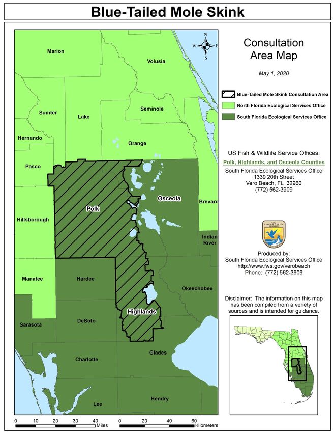
South Florida Ecological Services Field Office - Publication Date: August 12, 2020
Species Survey Guidelines - Sand Skink

Peninsular Florida Species CCG for Skinks                                             July 31, 2020 14

Figure 2. Blue-tailed mole skink consultation area. County names depicted in shadowed bold text
indicate the counties where skinks are known to occur

2/19/2023 1:31 PM                                 IPaC v6.88.0-rc2                            Page 14
South Florida Ecological Services Field Office - Publication Date: August 12, 2020
Species Survey Guidelines - Sand Skink

                                                                                     July 31, 2020
                                                  Appendix A

                               Sand Skinks and Blue-tailed Mole Skinks

                                               Survey Protocol
                                              Peninsular Florida

The U.S. Fish and Wildlife Service (Service) provides this revised skink survey protocol for all
counties in Florida in which the sand skink (Plestiodon [Neoseps] reynoldsi) and blue-tailed
(bluetail) mole skink (Plestiodon [Eumeces] egregius lividus) occur based on the 5-year status
review of the two species (Service 2007) and our assessment of skink surveys to date. The
purpose of this recommended survey protocol is to standardize survey and data collection
procedures among project proponents to ensure consistent and comparable information that may
improve our knowledge of the species’ occurrence and habitat use over space and time. The
current guidance will be updated as new information becomes available.

The three most important factors in determining the likelihood of presence of skinks are location,
elevation, and suitable soils. Sand skinks occur on sandy ridges of interior central Florida. The
extant range of the sand skink includes Highlands, Lake, Marion, Orange, Osceola, Polk, and
Putnam Counties (Christman 1988; Telford 1998). Principal populations occur on the Lake Wales
Ridge, Winter Haven Ridge, and Mount Dora Ridge (Christman 1970; Christman 1992;
Mushinsky and McCoy 1995). Blue-tailed mole skinks are only known to occur on the Lake
Wales Ridge in Highlands, Osceola, and Polk Counties (Mount 1965; Christman 1978). Both
skink species are found in this geographic area typically at elevations 82 feet (ft) (25 meters [m])
above sea level or higher (Florida Natural Areas Inventory 2007). A reference maps depicting the
consultation area can be found along with this protocol on our webpage
(www.fws.gov/verobeach). Sand skinks are more numerous, broadly distributed, and easily
detected than blue-tailed mole skinks. As such, sand skinks will be used as a proxy for both
species in the counties in which they co-occur (See Skink Conservation and Consultation Guide
for additional information).

Within appropriate geographic area and elevation, skinks are found in excessively drained, well-
drained, and moderately well-drained sandy soils. Suitable soil types include: Apopka,
Arredondo, Archbold, Astatula, Basinger, Candler, Daytona, Duette, Florahome, Gainesville,
Hague, Immokalee, Kendrick, Lake, Millhopper, Orsino, Paola, Placid, Pomello, Pompano,
Samsula, Satellite, Smyrna, St. Lucie, Tavares, Urband land (when open sandy soils persist and
remnant scrub remains), Zolfo, and Zuber. These soil types typically support scrub, sandhill, or
xeric hammock natural communities, although they may be degraded by human impacts to
overgrown scrub, pine plantation, citrus grove, old field, or pasture. Skinks have been found in
all these degraded conditions where soil types are suitable regardless of vegetative cover (Pike et
al. 2008a). Thus, habitat condition is of secondary importance in determining whether a site is
occupied by skinks. If a site has suitable soils at the appropriate elevation, vegetation does not
preclude coverboard placement, does not have a thick duff layer, and is within the counties

                                                         15

2/19/2023 1:31 PM                                 IPaC v6.88.0-rc2                               Page 15
South Florida Ecological Services Field Office - Publication Date: August 12, 2020
Species Survey Guidelines - Sand Skink
July 31, 2020
where skinks are known to occur, there is a likelihood of presence, and potential effects to skinks
should be considered.
When the location, elevation, and soil type are suitable and the proposed action may disturb the
soils on-site, then a skink survey is necessary to determine if the site is occupied.
Surveys can be conducted in a two-tiered approach to determine presence of skinks. A visual
pedestrian survey to detect skink tracks should be conducted first. This survey can be performed
at any time of the year, but tracks are most detectable in the spring (March through May) and fall
(October through November) (Ashton and Telford 2006; Pike et al. 2008b). We recommend a
thorough pedestrian survey be completed during one of these periods prior to proceeding with a
more intensive coverboard survey. Sand skinks leave a sinusoidal (“S”-shaped) track (Figure 1)
at the surface that can be readily identified through a visual pedestrian survey. All open, exposed
sandy areas on the property should be surveyed. The survey route (preferably global positioning
system [GPS] based) should be recorded and depicted in map form with all locations of skink
sign (skinks or skink tracks) marked. A photo documentation log of the skink signs should also
be provided.
If the pedestrian survey is negative on some or all portions of the site, then a coverboard survey,
with boards regularly dispersed across suitable soils, is necessary on those portions with negative
pedestrian survey results. Prior to initiating coverboard surveys, we strongly encourage you to
contact a Service biologist in the appropriate field office (Figure 2) to confirm survey dates,
obtain guidance on placement of the boards across the landscape, and determine if a site visit is
needed to verify sampling protocol. Note: Until additional research is conducted to determine
the likelihood of detection of skinks in dense bahiagrass fields, the Service biologist will need to
make a decision on a site-by-site basis as to whether surveys will be required in dense
bahiagrass.
Coverboard surveys should be conducted from March 1st through May 15th (Gianopulos 2001,
Mushinsky et al. 2001, Rizkalla et. al 2015). This time period was selected using the best
available science and is intended to account for yearly temperature fluctuations. Negative results
obtained outside this period of time are not considered adequate to presume absence of skinks.
Surveys should be conducted a minimum of four times during four consecutive weeks within the
survey time period to presume that skinks are not present. Coverboards must be lifted and
checked for tracks a minimum of once per week over the four consecutive weeks. It is important
to conduct surveys when survey conditions are suitable for detecting skinks (i.e., the surrounding
soil is not compacted as a result of rainfall or other events that may preclude skink movement,
such as atypical weather conditions).
Coverboards should be placed within suitable soil types at a minimum density of 100
coverboards per hectare (40 per acre). Coverboards should be located in areas of bare sand or
sparse vegetation adjacent to leaf litter or detritus. Carefully rake or grade the soil to ensure full
contact of the coverboard with the soil surface. Removal of soil from surrounding areas and
16
2/19/2023 1:31 PM IPaC v6.88.0-rc2 Page 16South Florida Ecological Services Field Office - Publication Date: August 12, 2020
Species Survey Guidelines - Sand Skink
July 31, 2020
placement under coverboards may be necessary where stems or roots preclude full contact of the
coverboard with the soil surface. The additional soil must be deep enough to allow skinks to
move through it and for tracks from their movements to be detectable (5 centimeters [cm]).
Certain conditions (overgrown scrub, old fields, pastures) may require vegetation to be removed
under specific coverboards to place a sufficient number of boards. Xeric scrub habitat where
skinks occur may also be occupied by rare, State and federally listed plants. While setting up
coverboard surveys, minimize effects to rare plant communities (For more information on plants,
see (http://www.archbold-station.org/html/linkpgs/archlistedsp.html).
Coverboards should be 61 cm by 61 cm (2 ft by 2 ft) in dimension and may be constructed of 1.2
cm (0.5 in) or greater thick plywood, masonite, rigid insulation board (without metallic
sheathing), carpet, or other rigid material of the same dimensions. Record the geographic
coordinates of all coverboards. Coverboards should be allowed to acclimate for 7 days before
the first sampling event. Therefore, the latest date that one could deploy coverboards and
complete the survey according to protocol in a given year is April 17.
Survey Season Begins Latest Date to Deploy Coverboards Survey Season Ends
March 1 April 17 May 15
Check for tracks upon lifting each coverboard. The use of gloves during sampling is highly
recommended as coverboards often attract venomous insects and reptiles. We recommend lifting
the coverboards from the edge farthest from you to keep the coverboard between you and any
potential threats. After checking for tracks and skinks, carefully smooth the soil surface with the
edge of the coverboard and replace the coverboard. During each site visit, look for and record
tracks in sandy patches between coverboard locations.
A survey report that includes the following, as applicable, should then be forwarded to the
Service:
1. Project description of the action including site-specific habitat and vegetative
descriptions, habitat structure (i.e., the extent of canopy, understory, and ground cover,
etc.), non-habitat structure (i.e., the extent of existing paved surfaces, existing structures,
and water bodies, etc.), and fire history, if available.
2. Soil map over a topographical map or aerial photograph of the project area including the
path of the pedestrian surveys, coverboard locations, and locations of skinks and skink
signs.
3. Photo documentation of tracks. All tracks resembling sand skink tracks should be
submitted for review to ensure that Peninsular mole skink tracks are not mistakenly
identified as sand skink tracks.
4. Field data sheets that include:
17
2/19/2023 1:31 PM IPaC v6.88.0-rc2 Page 17South Florida Ecological Services Field Office - Publication Date: August 12, 2020
Species Survey Guidelines - Sand Skink
July 31, 2020
A. Survey dates with starting and ending times of all surveys conducted and personnel
conducting surveys;
B. Weather conditions during all surveys, including average temperature, wind speed
and direction, visibility, and precipitation;
C. Total number of skink tracks observed; and
D. All skink observations.
5. The following ArcGIS layer files in shapefile format that include accurate metadata (the
preferred projection is Florida Albers NAD83 in meters):
A. Project boundary;
B. GPS locations of survey routes;
C. Coverboard locations; and
D. Skink and skink track/sign locations.
LITERATURE CITED
Ashton, K.G. and S.R. Telford, Jr. 2006. Monthly and daily activity of a fossorial lizard, Neoseps
reynoldsi. Southeastern Naturalist 5(1):175-183.
Christman, S.P. 1970. The possible evolutionary history of two Florida skinks. Quarterly Journal
of the Florida Academy of Science 33(4): 291-293.
Christman, S.P. 1978. Threatened: bluetailed mole skink, Eumeces egregius lividus (Mount).
Pages 38-41 in R.W. McDiarmid, editor. Rare and endangered biota of Florida. Volume
3: amphibians and reptiles. University Press of Florida; Gainesville, Florida.
Christman, S.P. 1988. Endemism and Florida’s interior sand pine scrub. Final project report
no.GFC-84-010, Florida Game and Fresh Water Fish Commission; Tallahassee, Florida.
Christman, S.P. 1992. Threatened: sand skink, Neoseps reynoldsi (Stejneger). Pages 135-140 in
P.E. Moler, editor. Rare and endangered biota of Florida. University Press of Florida,
Gainesville, Florida.
Florida Natural Areas Inventory. 2007. "FNAI FLEO Internal, March 2007" for Eumeces
egregius lividus and Neoseps reynoldsi. Data file submitted to U.S. Fish and Wildlife
Service, Vero Beach, Florida. June 12.
Gianopulos, K.D. 2001. Response of the threatened sand skink (Neoseps reynoldsi) and other
herpetofaunal species to burning and clearcutting in the Florida sand pine scrub habitat.
M.S. Thesis, University of South Florida, Tampa, Florida.
18
2/19/2023 1:31 PM IPaC v6.88.0-rc2 Page 18South Florida Ecological Services Field Office - Publication Date: August 12, 2020
Species Survey Guidelines - Sand Skink
July 31, 2020
Mount, R.H. 1965. Variation and systematics of the scincoid lizard, Eumeces egregius (Baird).
Bulletin of the Florida State Museum. 9(5):183-213.
Mushinsky, H.R. and E.D. McCoy. 1995. Vertebrate species compositions of selected scrub
islands on the Lake Wales Ridge of Central Florida. Florida Game and Fresh Water Fish
Commission, Nongame Wildlife Program, Project Report GFC-87-149; Tallahassee,
Florida.
Mushinsky, H.R., E.D. McCoy, K. Gianopulos, K. Penney, and C. Meyer. 2001. Biology of the
threatened sand skink on restored scrub habitat and its responses to land management
practices. Final report to the Disney Wildlife Conservation Fund. University of South
Florida, Tampa, Florida.
Pike, D.A, K.S. Peterman, and J.H. Exum. 2008a. Habitat structure influences the presence of
sand skinks (Plestiodon reynoldsi) in altered habitats. Wildlife Research 35: 120-127.
Pike, D.A, K.S. Peterman, R.S. Mejeur, M.D. Green, K.D. Nelson and J.H. Exum. 2008b.
Sampling techniques and methods for determining the spatial distribution of sand skinks
(Plestiodon reynoldsi). Florida Scientist 71-02-01.3d
Rizkalla, C. E., McCoy, E. D., Britt, E. J., & Mushinsky, H. R. 2015. Indirect monitoring of a
rare lizard: effects of sampling intensity, season, and management practices.
Herpetological Conservation and Biology, 10(3), 894-903.
Telford, S.R., Jr. 1998. Monitoring of the sand skink (Neoseps reynoldsi) in Ocala National
Forest. Final report submitted to U.S. Forest Service, Ocala National Forest, Silver
Springs, Florida.
U.S. Fish and Wildlife Service (Service). 2007. Bluetail mole skink (Eumeces egregius lividus)
and sand skink (Neoseps reynoldsi) [Internet]. 5-year review: summary and evaluation.
South Florida Ecological Services Office, Vero Beach, Florida [cited October 29, 2008].
Available from: http://ecos.fws.gov/docs/five_year_review/doc1071.pdf
19
2/19/2023 1:31 PM IPaC v6.88.0-rc2 Page 19South Florida Ecological Services Field Office - Publication Date: August 12, 2020
Species Survey Guidelines - Sand Skink
July 31, 2020
Figure 1. Typical “S”-shaped track of the sand skink (photographs courtesy of Randy Mejeur;
Glatting Jackson Kercher Anglin Lopez Rinehart, Inc; 2000).
20
2/19/2023 1:31 PM IPaC v6.88.0-rc2 Page 20South Florida Ecological Services Field Office - Publication Date: August 12, 2020
Species Survey Guidelines - Sand Skink
July 31, 2020
Figure 2. Sand skink and blue-tailed mole skink survey protocol: US Fish and
Wildlife Service areas of responsibility.
21
2/19/2023 1:31 PM IPaC v6.88.0-rc2 Page 21South Florida Ecological Services Field Office - Publication Date: August 12, 2020
Species Survey Guidelines - Sand Skink
July 31, 2020
Appendix B
Sand Skinks and Blue-tailed Mole Skinks
Estimating Skink Habitat Use on a Project Site
Peninsular Florida
The results of the surveys can be used to estimate how much of the total area is likely occupied
by skinks. In the absence of data to estimate the average home range size of skinks, data on
movement distances is being used to approximate usage of habitat around positive skink
detections. It is the Service's opinion that any suitable habitat within 80 ft of a sand skink track
is reasonably certain to be occupied, and any activities that occur within that radius which are
reasonably certain to harm sand skinks would be considered incidental take as defined by the
Endangered Species Act. The information that supports 80 ft as the radius includes: 1) Penney
(2001), who reported translocated sand skinks moved a median distance of 25.6 m (84 ft; n =
64); 2) Schrey et al. (2011), who conducted a genetic analysis of sand skinks (n = 470) within 25
m of each other, and reported "the Florida sand skink occurs with higher genetic similarity than
expected by chance within 25 m (82 ft)"; and 3) Perry and Garland (2002), who reviewed the
literature and examined home range as a function of snout-vent length in lizards. Of the 489 data
sets they examined, 108 met their criteria for their analysis. Lizards of the Autarchoglossa (the
clade that contains all skink species) with snout-vent lengths ranging from 30 millimeters (mm)
to 100 mm (i.e., the range representative of sand skinks) had home ranges of approximately 10
m2 to approximately 1,700 m2. A 1,700 m2 area has a radius of 23 m (75 ft).
To estimate habitat use, the project proponent should follow the steps below:
Step 1. Using the results of fully-implemented coverboard surveys, pedestrian surveys, and any
incidental observations of skinks or their sign, map the positive survey hits/tracks, etc.
Note: Pedestrian surveys may not be used solely to estimate habitat use but still may be
used prior to coverboard surveys to potentially narrow down the number of coverboards
needing to be deployed.
Step 2. Using mapping software, generate a buffer with a radius of 80 feet (24.4 meters) around
each positive survey hit/track from all coverboard and pedestrian surveys, as well as
incidental observations, to estimate the area of habitat use. Although this may result in
some buffers that come close to each other but do not overlap, the applicant will have the
option (but not be required) to connect circles to better depict the total area of use by the
skink population on site.
22
2/19/2023 1:31 PM IPaC v6.88.0-rc2 Page 22South Florida Ecological Services Field Office - Publication Date: August 12, 2020
Species Survey Guidelines - Sand Skink
July 31, 2020
Step 3. When drawing the 80-foot radius around positive skink survey hits/tracks, the area of
habitat use for compensation will be determined by calculating the total area of suitable
soils within the circle(s). If areas within the circle(s) are unsuitable (i.e., paved road, not
one of the suitable skink soils), then these specific portions may be subtracted from the
total area of habitat use for compensation calculation. Note that evaluation of dense
bahiagrass is on a case-by-case basis until further studies can provide better guidance.
Step 4. If a portion of the circle(s) is outside of the project footprint, it will need to be evaluated
for impacts from the project, as well, if it falls within the action area (all areas, whether
inside or outside of the project footprint that will be affected by the proposed action). If
the action area for the proposed project extends beyond the project boundary, then any
portion of the circle(s) drawn outside of the project boundary but within the action area
should be included in the compensation calculation. If the action area is fully contained
within the project boundary, then portions of the circle(s) outside of the project boundary
will require no compensation, and the area may be subtracted from that circle(s). If the
buffers of multiple positive skink hits/tracks overlap, then the sum total of the areas of
those circles will be used to determine the occupied area(s) (Figure 1).
Figure 1. Diagram of habitat use estimation using buffered coverboard survey results with skink
detections over 4-week survey period. Note: The number of coverboards represented within
each 80-foot buffer is not to scale. Estimated skink habitat use = the entire area within the red
circle + the area within the blue circle that falls outside of the red circle.
23
2/19/2023 1:31 PM IPaC v6.88.0-rc2 Page 23South Florida Ecological Services Field Office - Publication Date: August 12, 2020
Species Survey Guidelines - Sand Skink
July 31, 2020
Step 5. To obtain the total area of habitat being used by skinks on the project site, add the area of
all the circles drawn around positive skink survey hits/tracks and subtract the area of the
footprint of any features (non-suitable soils, paved roads, buildings, water bodies, etc.)
within the circles that are not considered by this guide to be skink habitat. This
information should be mapped and provided to the Service to show how the final number
of acres for compensation were derived.
Step 6. See Appendix C for potential conservation measures that project proponents may
incorporate into their projects in order to avoid, minimize, compensate, and mitigate the
effects of those projects on listed skinks.
24
2/19/2023 1:31 PM IPaC v6.88.0-rc2 Page 24You can also read