St Stephen Parish Neighbourhood Plan - Consultation Statement to accompany The Submission Version (Regulation 16) Neighbourhood Plan February 2021
←
→
Page content transcription
If your browser does not render page correctly, please read the page content below
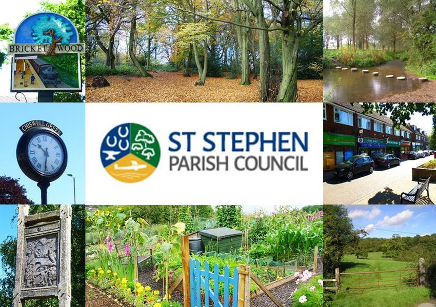
St Stephen Parish
     Neighbourhood Plan

 Consultation Statement to accompany
The Submission Version (Regulation 16)
         Neighbourhood Plan

            February 2021

                                         1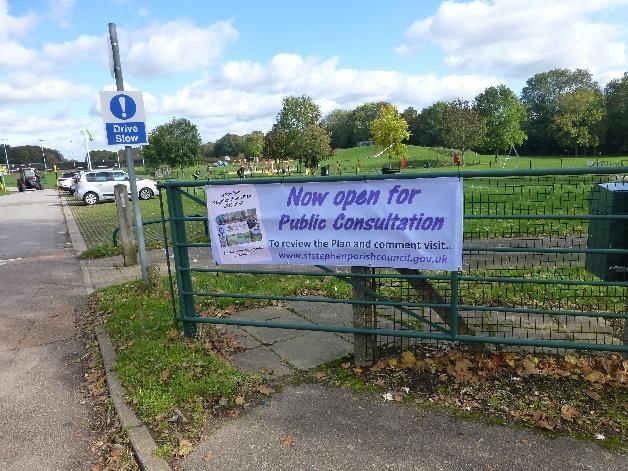
Contents
1.      INTRODUCTION ......................................................................................................................... 3
     About St Stephen Parish ................................................................................................................ 3
2.      SUMMARY OF ENGAGEMENT AND CONSULTATION ACTIVITIES, ISSUES AND OUTCOMES .......... 4
     Stage I: Launching the Plan, seeking input and involvement from the community and local
     businesses ..................................................................................................................................... 4
     Stage II: Actions informing and involving the local community and businesses of the Plan and its
     progress (ongoing)......................................................................................................................... 5
     Stage III: Exploring potential sites for development ....................................................................... 8
     Stage IV: Creating the draft Plan .................................................................................................... 9
     Stage V: Preparing Pre-Submission (Regulation 14) Draft Neighbourhood Plan ............................ 10
     Stage VI: Preparing the Submission (Regulation 16) Neighbourhood Plan .................................... 13
3.      STRATEGIC ENVIRONMENTAL ASSESSMENT AND HABITATS REGULATION ASSESSMENT .......... 16
     Strategic Environmental Assessment ........................................................................................... 16
     Habitats Regulations Assessment (HRA) ....................................................................................... 17
4.      CONCLUSION ........................................................................................................................... 18

APPENDIX A: Timeline summary of significant engagements, events and activities
APPENDIX B: Feedback from “What to Build? Where to Build?” community events
APPENDIX C: List of statutory consultees and correspondence sent at Regulation 14
APPENDIX D: Summary of Regulation 14 statutory consultee responses
APPENDIX E: Summary of feedback received from the local community

                                                                                                                                                     2
1. INTRODUCTION
1.1.       This consultation statement has been prepared in accordance with regulation 15(2) of
           Neighbourhood Planning Regulations 2012, which requires that a consultation statement
           should:
       •     contain details of the persons and bodies who were consulted about the proposed
             neighbourhood development plan;
       •     explain how they were consulted;
       •     summarise the main issues and concerns raised by the persons consulted; and
       •     describe how these issues and concerns have been considered and, where relevant,
             addressed in the proposed Neighbourhood Plan.

1.2.       The policies contained in the St Stephen Parish Neighbourhood Development Plan (‘the Plan’)
           have been developed as a result of extensive interaction and consultation with the community
           and businesses within St Stephen Parish. The Plan reflects the views of the majority of the
           community. Engagement with the community has been through ongoing publicity campaigns
           which have included leaflet drops to households, public meetings, exhibitions, a Community
           Survey and culminating (to date) with the Public Consultation.

1.3.       All activity has been overseen and coordinated by St Stephen Parish Council via a dedicated
           Steering Group and a suite of topic-specific Working Parties. The process has been supported
           throughout by Alison Eardley Consulting neighbourhood planning consultants, appointed
           following a tendering exercise.

About St Stephen Parish
1.4.       St Stephen Parish lies some 20 miles north of London, in the southwest corner of Hertfordshire
           between the City of St Albans and the town of Watford. It falls under the administrative control
           of St Albans City and District Council. The Parish comprises three villages, Bricket Wood,
           Chiswell Green and Park Street, the latter also incorporating the residential area known as How
           Wood and the smaller hamlets of Frogmore and Colney Street.

1.5.       The 2011 national census records the Parish’s population as 13,865, living in 5,815 dwellings.
           Adjacent to both the M1 and M25 motorways and within the ‘commuter belt, the Parish is a
           popular residential area with higher than average property prices.

1.6.       The Parish has a higher than average parentage of older residents compared to both national
           and district figures with around 20% of residents aged over 65. There is a high level of home
           ownership; 82% compared to District (73%) and National (63%). There is a noticeably higher
           than average car ownership, fuelled by the Parish’s rural location and inadequate public
           transport facilities.

1.7.       The Parish’s population is likely to increase markedly in the future with several large
           developments underway, notably in Bricket Wood. Longer term, the emerging Local Plan will
           set out a revised growth strategy for the district.

                                                                                                         3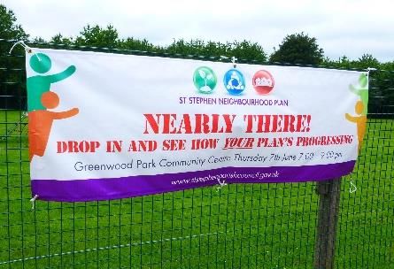
2. SUMMARY OF ENGAGEMENT AND CONSULTATION ACTIVITIES, ISSUES AND
   OUTCOMES

2.1. Appendix A contains a timeline summary of significant engagements, events and activities.
Stage I: Launching the Plan, seeking input and involvement from the community and local
businesses
2.2. Steering Group: An initial group comprising Parish Councillors had come together to head the
     process. They sought volunteers from the community to join, using the council meetings, the
     launch meeting and local drop-in days to garner interest. This led to the establishments of a
     Steering Group comprising a number of St Stephen Parish councillors, representatives from the
     three villages in the Parish, supported by an appointed external consultant.

2.3. The Steering Group has met regularly since the inception of the Plan, although latterly via ‘virtual’
     meetings due to COVID-19 restrictions. Meetings have also been held throughout the process
     with developers, representatives of St Albans City and District Council and other relevant bodies
     including local major employers and adjacent parishes.

2.4. Launching the Plan: St Stephen Parish Council, the formal lead on the Plan, agreed to initiate the
     development of a Neighbourhood Plan in 2015. The Parish Council communicated its intention
     to residents through its parish-wide newsletter, with an article in the local press and posters
     around the parish. Following these actions, a Public Launch event was held at the Parish Centre
     on 31st March 2015 to introduce and explain more fully the concept and the importance of the
     Neighbourhood Plan to residents and receive input from the community on issues and concerns.
     Attendees were invited to use post-it notes to input their thoughts on a series of broad questions:
     what they like about the Parish, what they dislike, ideas for the future and areas to be
     safeguarded.

2.5. This exercise was repeated at each of the settlements: Bricket Wood (19 May 2015), Chiswell
     Green (30 May) and Park Street (4 July). The Annual Parish meeting on 30 April provided a further
     opportunity to share with the local community the programme ahead.

2.6. Working Groups: A summary of the
     feedback gathered across each of the
     events was collated, which enabled the
     Steering Group to consider five themes
     to underpin the work ahead:
            • Housing
            • Green Spaces and the
                Environment
            • Transport and Movement
            • Community Facilities
            • Local Economy
                                                           The Working Group Briefing Session

                                                                                                        4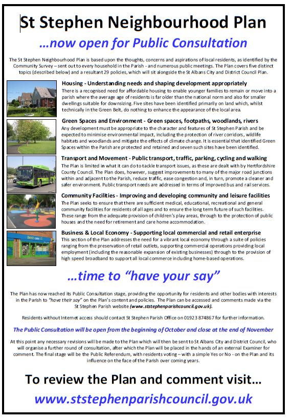
Each theme was allocated a Working Group comprising a Chair from the Steering Group and
       volunteers from the community who had expressed an interest to get involved. A briefing session
       was held in August 2015, hosted by the Consultant, to set out the key tasks for the groups.

2.7. The Working Groups met regularly, defining issues, researching, data gathering, paying site visits
     and initiating dialogue with relevant organisations and individuals. This enabled them to
     contribute to an initial broad set of aspirations, which would be honed into a draft vision and
     objectives, to be tested with the local community.

       Main points identified for inclusion in the emerging Vision

2.8. The Working Groups also played a key role in putting together a detailed survey to the local
     community, described further in Stage II.

Stage II: Actions informing and involving the local community and businesses of the Plan and its
progress (ongoing)

2.9.    Publicity and Interaction with the Community: Since the inception of the Plan, local residents
        have been kept informed of the Plan’s launch and progress, with special emphasis on important
        key stages such as Public Meetings, the Community Survey, Public Exhibitions and the Public
        Consultation. Communications have included:
           • Regular Press Releases to local media
           • Tailored editorials and advertising in local Residents’ Associations’ magazines
           • Editorials submitted to other local organisations’ publications.
           • Information sent to local schools and churches for use in newsletters.

                                                                                                     5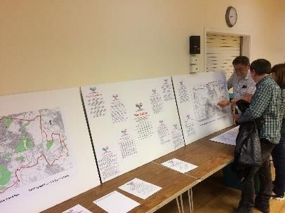
• Numerous poster ‘campaigns’ supplemented
           with larger banners placed at strategic points
           in the Parish to publicise key stages, such as
           Public Meetings, the Community Survey, the
           Pubic Exhibition and the Public Consultation.
         • Mailshots delivered to every household in the
           Parish at the initial launch of the Plan, to
           deliver the Community Survey and to
           announce the Regulation 14 Public
           Consultation.
         • A dedicated set of webpages on the Parish
           Council website
         • The St Stephen Parish triannual newsletter
           running regular updates on the Plan’s
           progress.

2.10. Community Survey: In July 2016, a Community Survey                   Example poster
      was created with questionnaires sent to every residence
      in the Parish within the autumn edition of the Parish newsletter. The Survey included questions,
                                                   defined by the Steering Group and the Working
                                                   Groups, on the five topic areas. In addition, the
                                                   Survey also included ‘lifestyle’ questions relating to
                                                   the community’s general feelings about the Parish.

                                                   2.11. ‘Collection Boxes’ were placed in parish
                                                   offices, local shops, post offices and doctors’
                                                   surgeries to collect completed questionnaires.
                                                   Residents were also able to complete the
                                                   questionnaire online. A total of 590 responses were
                                                   received, equating to 11% of the households in the
                                                   Parish. The results of the Survey provided the
                                                   Steering Group and Working Groups with a still
                                                   wider understanding of residents’ views and
                                                   aspirations, enabling a further layer of refinement
                                                   in the formulation of their Plan.

               The Community Survey

2.12. A summary of the findings can be found on the St Stephen Parish Council website:
      https://ststephen-pc.gov.uk/wp-content/uploads/2020/11/7.-2016-Neighbourhood-Plan-
      Survey-results.pdf. The findings enabled the Steering Group to develop an evolved Vision and
      Objectives.

                                                                                                       6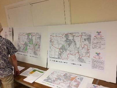
2.13. Topic based research and engagement: Alongside the Parish-wide community survey, each of
      the Working Groups undertook research and engagement on topics specific to them:

2.14. The Local Economy Working Group developed a
      list of all businesses operating in the Parish and
      wrote to them to seek views and also invite them
      to take part in one of two Focus Groups, one for
      larger businesses and the other for smaller ones.
      Topics discussed included transport, workforce
      issues, supplies and expansion plans. The group
      also visited retail and other outlets in the Parish
      to make contact and seek views.

2.15. The Community Facilities Working Group
      undertook an initial analysis of the Strengths,
      Weaknesses, Opportunities and Threats for
      facilities in the Parish.     They prepared a
      comprehensive detail of what facilities were
      available and future plans for them. Meetings
      with residents’ associations were held and older
      people’s groups. Finally, a Youth Survey was
      created with input from the local Scouts group,
      to understand what facilities older children/
      teenagers wished to see in the Parish.
                                                                  Letter sent to local businesses

2.16. The Transport and Movement Group undertook research including into the following topics:
      cycleways, footpaths, bridleways, public transport, car parking (including for commuters and
      for use by those accessing local shops), traffic congestion and road conditions. Members of the
      group explored existing policy and its impact on St Stephen Parish, including the Hertfordshire
      County Council Local Transport Plan, as well as implications for future works in the area, such
      as improvements to the Abbey ‘Flyer’ rail line and bus services. Some of the topics discussed
      were considered to be beyond the scope of the Neighbourhood Plan, but nevertheless were
      important issues raised by the community and were, therefore, included in the Non-Policy
      Action table. The more localised issues, such as traffic pinchpoints and the need to promote
      active travel, provided valuable detail for the Plan.

2.17. The Green Spaces and the Environment Group prepared a detailed profile as evidence to
      underpin the Neighbourhood Plan. This included information gathered on local green assets in
      the Parish and drew on discussions held with a range of parties including District Council
      officers, local walking groups and the River Ver Society. The group prepared the justifications
      for the spaces nominated for Local Green Space designation, and prepared information on other
      local features of the Parish including woodland, the river system and the wider network of green
      infrastructure.

2.18. The work of the Housing Working Group is described below.

                                                                                                    7
Stage III: Exploring potential sites for development
2.19. In parallel with the work taking place to engage the local community and the activities of the
      Working Groups, the Steering Group considered whether the Neighbourhood Plan should
      explore the allocation of sites for housing. Whilst the feedback from the local community
      revealed a keen desire to protect the Green Belt, comments were also received about the cost
      of housing locally and the lack of availability of smaller homes, in particular suited to those
      wishing to downsize and those entering the
      housing market (both for sale and to rent). There
      were already some sites with planning permission
      within the Parish and the emerging Local Plan at the
      time was seeking to allocate ‘broad locations’ for
      largescale development. Nevertheless, what these
      did not address, potentially, was housing needs at
      the local community level.

2.20. Early on in the process, therefore, AECOM was
      commissioned to carry out a local Housing Needs
      Assessment for the Parish to provide additional
      local detail on the numbers of houses that might be
                                                                Local Housing Needs Assessment
      required within the Parish over the period of the
      Plan and also the type and tenure of these. The final 1report, published June 2017, suggested a
      figure of between 875 and 900 dwellings would be required to address housing needs over the
      period to 2032, equating to 90 properties a year.

2.21. While this report was being compiled, the Steering Group initiated a local Call for Sites, inviting
      local landowners, developers and others to submit any land that they wished to be assessed for
      the purposes of the Neighbourhood Plan. The Call for Sites was advertised online, in the local
      press and with local agents.

2.22. The local Call for Sites, combined with the list of sites previously submitted to St Albans City and
      District Council (SADC) as part of its Call for Sites programme, brought about a list of potential
      sites totalling circa 80. AECOM were again commissioned to assess each of the sites to
      understand which would be suitable and available for development. The Steering Group
      contributed to the site assessment pro-forma by adding some additional criteria felt to be
      important at the local level, for instance whether the site fell within the Watling Chase
      Community Forest Area.

2.23. The assessment process led to a longlist of sites that were potentially suitable for development.
      All of these were located in the Green Belt; early discussions with SADC revealed support for
      the Neighbourhood Plan to amend the Green Belt boundaries, in line with the updated National
      Planning Policy Framework, and to allocate sites within the Neighbourhood Plan. It was
      confirmed by officers that a strategic need for such amendments would be identified in the

1
 https://ststephen-pc.gov.uk/wp-content/uploads/2020/11/4.-St-Stephen-Parish-Housing-Needs-
Assessment_FINAL.pdf

                                                                                                        8
emerging Local Plan, which was anticipated to be adopted well in advance of the
      Neighbourhood Plan.

2.24. Public Sites Exhibition: The longlist of potential sites was subject to public consultation at three
      events organised in each of the villages: These ‘What to build? Where to build’ meetings
      included a general introduction to the neighbourhood plan process and an overview of how the
      sites had been collated. Large maps of each of the sites were prepared and local people were
      given an opportunity to input their views on post-its, feedback forms or directly to the Steering
      Group.

2.25. The findings from the public engagement (shown in Appendix B combined with the finalised site
      assessments, led to a shortlist of six sites to be considered. The events also provided an
      opportunity to share the evolved vision and objectives with the local community, which was
      welcomed.

2.26. Meeting with site promoters: Each of the shortlisted site promoters was invited to meet the
      Steering Group to provide further information about what they had planned for their sites and
      to hear about the objectives of the Neighbourhood Plan. This was considered helpful in shaping
      the site allocation policies. Discussions were also held with SADC officers to gain feedback from
      their perspective.

2.27. A draft policy for each site, supported by evidence including why the sites no longer were
      considered to meet the Green Belt requirements was produced. Detail is enclosed in the
      Housing Report2. These were to be included in the Regulation 14 Pre-Submission Version draft
      Neighbourhood Plan.

Stage IV: Creating the draft Plan
2.28. Following the Working Groups’ activities, the Community Survey, the Public Meetings, the
      AECOM Report and the Call for Sites, the Steering Group was able to prepare an initial draft of
      the Plan and, from this, a suite of both policies and actions to address the Plan’s vision and
      objectives. A public exhibition was held to share this information and provided a further
      opportunity for comment.

                                               Public exhibition

2
 https://ststephen-pc.gov.uk/wp-content/uploads/2020/11/6.-St-Stephen-Parish-Neighbourhood-Plan-
Housing-Report.pdf

                                                                                                        9
2.29. It was not until this stage of the work – where an initial draft has been developed – that SADC
were in a position to formally screen the Plan to ascertain whether or not a Strategic
Environmental Assessment (SEA) and/or Habitats Regulations Assessment (HRA) would be
required. The Parish Council prepared the screening documentation, which was issued for
consultation with Historic England, Natural England and the Environment Agency in March and
April 2019. The Screening Opinion, published in May 2019, concluded that an SEA would be
required. It also concluded that an HRA was not required. A copy of the Screening
Determination (May 2019) is contained in the Evidence Base.
2.30. The Steering Group had commissioned AECOM, via Locality, to prepare an SEA in anticipation
of this being required. Due to the number of sites, this took some time to complete. There was
also a growing concern about the ongoing delays to the Local Plan process, which has been
anticipated to conclude well in advance of the Neighbourhood Plan; the emerging Local Plan
would determine the ‘strategic need’ for minor amendments to the Green Belt to be made
within the Neighbourhood Plan. It was considered at this time that the emerging Local Plan
would still be adopted in advance of the Neighbourhood Plan.
2.31. At this time, the draft Neighbourhood Plan was presented to SADC for informal comments,
which were integrated into the document.
Stage V: Preparing Pre-Submission (Regulation 14) Draft Neighbourhood Plan
2.32. Following the completion of the SEA, the Pre-submission Version (Regulation 14)
Neighbourhood Plan was finalised in readiness for the Regulation 14 consultation, which ran for
an eight-week period from 5 October to 30 November 2020. This was extended to take account
of the challenges posed to engagement by the Covid-19 pandemic. It should be noted that the
emerging Local Plan was still being examined at this point, and there was a concern about what
the outcome of that examination might be. To this end, a Notice was included in the Regulation
14 consultation draft to the effect that should the Local Plan not succeed at examination, the
sites contained within the Neighbourhood
Plan would need to be removed, given that it
was the emerging Local Plan that would have
provided the strategic need to amend Green
Belt boundaries, as set out in the NPPF.
2.33. The Consultation was publicised on the Parish
website, via social media, local Residents’
Associations’ magazines and other
organisations’ newsletters. Additionally, a
mailshot was delivered to every property in
the Parish, posters placed in local retail One of the publicity banners
outlets, public houses, bus shelters and Parish
notice boards and larger banners displayed at strategic points in the Parish.
10The flier sent to every property in the Parish
112.34. The Parish website included:
• The draft Plan
• An extract of the Plan’s policies
• Details of how to comment on the Plan by either the online questionnaire (via an
accessible link), by email or in writing.
2.35. The website also included additional relevant information and support documentation
including:
• ‘Quick Guide to Neighbourhood Plans’
• Neighbourhood Plan Community Survey results
• SEA Report – June 2020, AECOM
• SEA Report: Appendix A – Scoping Report for Consultation September 2019, AECOM
• Housing Needs Assessment June 2017, AECOM
• Site Assessment Report December 2017, AECOM
• Housing Report prepared by the Steering Group, October 2020
2.36. Alongside the community consultation, in accordance with the requirements of the
Neighbourhood Planning regulations, relevant statutory consultees were notified and a range
of other and organisations considered to have a particular interest in the Plan were also written
to. This included all of the owners of the Local Green Spaces. A list of consultees contacted is
contained in Appendix C alongside a copy of the correspondence sent to them. Responses were
received from the following:
• Historic England
• Natural England
• Environment Agency
• DPV for Castleoak ref. Land at Burston Nurseries
• St Albans District Council
• Highways England
• The Ramblers Association
• Turley on behalf of TARMAC
• Hertfordshire County Council
• DLA ref. land adjacent to Burston Nurseries, Chiswell Green
• DLA ref. Bucknalls Drive
• St Albans Cycle Campaign
• Aldenham Parish Council
• Bloor Homes
• Cllr David Parry
• British Horse Society
A summary of the comments received from these, with a response from the Steering Group, is
contained in Appendix D.
122.37. Plans to hold a series of Public Meetings and Presentations to residents had to be negated due
to the COVID-19 virus. These were replaced by an online ZOOM ‘Presentation and Public
Meeting’ on Monday 9 November 2020, held in the early evening to capture ‘workers’. This
virtual meeting, advertised on the Parish website and by a second poster campaign, attracted
over 50 attendees. The session was recorded3 and advertised on the Parish Council website for
those unable to attend the Zoom session.
2.38. The virus also meant that the intention of placing hard copies of the draft Plan in local venues,
such as doctor’s surgeries, public houses and post offices, was also not possible. However, the
Parish website advertised that hard copies would be made available to individuals on request.
2.39. A Consultation Survey was put together, available to complete online and also in paper form if
required.
2.40. Response to Survey: The Consultation Survey attracted 89 completed online questionnaires
during the eight-week period, although five without a name or postcode recorded have been
discounted, leaving a net 84 responses containing 197 comments. When added to emails,
letters and other responses over 250 comments were received. These comments were analysed
and considered by the Steering Group with regard to amending or making additions to the draft
Plan.
2.41. A summary of the responses from the community are included in Appendix E.
Stage VI: Preparing the Submission (Regulation 16) Neighbourhood Plan
2.42. The following paragraphs provide a summary as to the main comments about and revisions
made to the Neighbourhood Plan following the Regulation 14 consultation:
2.43. General comments: The emerging St Albans Local Plan 2018 was withdrawn on 19 November
2020 following its Examination. This took place during the Regulation 14 consultation. This
meant that all references to the emerging Local Plan had to be removed. Fundamentally, this
meant removing the proposed site allocations from the Neighbourhood Plan as all of these
relied on the amendment of Green Belt boundaries; the adopted Local District Plan Review 1994
pre-dates the NPPF and hence does not establish a strategic need to review Green Belt
boundaries at a Neighbourhood level. The emerging Local Plan had been anticipated to be
adopted in advance of the Neighbourhood Plan and would have established this.
2.44. Locality’s Site Assessment for Neighbourhood Plans Guidance states: “Where you cannot
demonstrate that a site is deliverable, for example it may be in a good location but there is no
evidence that it could become available, your plan can identify ‘aspirations’ for sites you would
like to see developed, and set out principles for each site linked to plan policies.” Whilst the
proposed site allocations have been removed from the Plan, the detail of those considered
suitable are contained in the Housing Report accompanying the Plan and are considered as
3
https://www.youtube.com/watch?v=d9y0IqVyEEQ
13Aspirational Sites that should be revisited in either a future review of the SSNP or as part of the
new emerging Local Plan process.
2.45. The SEA Screening was reissued to take account of the fact that the sites had been removed
from the Plan. A new Screening Determination Statement concluded that the Plan would not
require an SEA.
2.46. This has led to some changes to the maps within the document.
2.47. Character Heritage and Design policies: The policies were largely supported by those
responding to the consultation. Historic England queried whether there was scope to include a
policy to consider local heritage assets and local character. The Steering Group agreed that this
would be helpful and included a policy to ensure that any new development within the villages
should be in-keeping with the prevailing character of the village. Furthermore, the group
identified two non-designated heritage assets to be preserved – the Parish Barn, owned by the
Parish Council, and St Luke’s Church, both in Bricket Wood – alongside acknowledging the non-
listed historic assets maintained on the Historic Environment Record. The owners of these
assets were contacted about the designation and supported this.
2.48. Green spaces and the environment: The owners of each of the proposed Local Green Spaces
were contacted at Regulation 14 consultation. No negative feedback was received. The
Environment Agency were very supportive of the policy to enhance the river setting, although
they did raise concerns in the Strategic Environmental Assessment that accompanies the
Neighbourhood Plan about the Ver and Colne rivers being susceptible to flooding. Therefore,
the policy has been amended to support proposals that incorporate natural flooding
mitigations, such as planting indigenous trees which help prevent soil erosion. The Steering
Group discussed flooding more generally in the Parish and agreed that flooding has
predominantly been an issue in relation to the maintenance of drains as opposed to a
development issue.
2.49. Transport and movement: Hertfordshire County Council raised concerns about Policy S12 (Off-
street car parking), which was felt to be in contrast to the country-wide aspiration to shift
towards non-car modes of transport. This aspiration to move to more sustainable modes of
transport is shared by the Steering Group, however a sense of realism was considered necessary
in the context of St Stephen being a largely rural area with high car dependency when compared
to the region and nationally. The motorway network cuts through the Parish and contributes
significantly to traffic congestion. Lack of off-street parking is considered to exacerbate this,
therefore, on balance it is felt appropriate to retain the policy intending to safeguard existing
parking and replace it when it is lost. Furthermore, the policy has been amended to support EV
charging points, which would still require parking spaces, albeit cleaner vehicles.
2.50. The policies relating to walking, cycling and horse-riding were strongly supported.
2.51. Community facilities: The feedback was very supportive. The policies on community facilities
and local public houses have been merged for simplification.
142.52. Business and local economy: All policies were supported.
2.53. Following the revisions made to the Plan as a result of the Regulation 14 consultation, the
amended Plan was approved at a meeting of St Stephen Parish Council on 18 February 2021.
The Submission Version was submitted to St Albans City and District Council at Regulation 16 in
February 2021. Assuming a favourable outcome, it will proceed to Examination and then to
referendum.
153. STRATEGIC ENVIRONMENTAL ASSESSMENT AND HABITATS REGULATION
ASSESSMENT
Strategic Environmental Assessment
3.1. The St Stephen Parish Neighbourhood Plan and the process under which it was made conforms
to the SEA Directive (EU 2001/42/EC) and the Environmental Assessment of Plans and
Programmes Regulations 2004 (the Regulations).
3.2. A draft version of the Plan was screened in March/April 2019 to determine whether or not it
required a Strategic Environmental Assessment (SEA) in accordance with the European Directive
2001/42/ EC and associated Environmental Assessment of Plans and Programmes Regulations. A
Screening Opinion was published in May 2019 stating that an SEA was required, primarily because
of the inclusion of site allocations on previously undeveloped greenfield land and the potential
impacts this might have.
3.3. Since that initial screening, changes have been made to the Neighbourhood Plan that warrant a
new screening; all site allocations have been removed from the Neighbourhood Plan. This is due
to the fact that all proposed sites were located in the Green Belt; the Neighbourhood Plan was
seeking to amend the Green Belt boundaries, as enabled through para 136 of the National
Planning Policy Framework, and allocate them for housing. Whilst the NPPF enables
neighbourhood plans to make alterations to the Green Belt boundary, however, this can only
happen where a need to do so has been established at the strategic level, in this case the St
Albans Local Plan. St Albans had been working on a new Local Plan to replace the saved policies
of the existing Local Plan Review 1994. It had been anticipated that the new Local Plan 2018
would establish a strategic need for the review of Green Belt boundaries at the neighbourhood
level. It was also anticipated that the emerging Local Plan 2018 would have been adopted well in
advance of the St Stephen Neighbourhood Plan. In fact, the emerging St Albans Local Plan 2018
was withdrawn on 19 November 2020 following its Examination. The existing adopted Local
District Plan Review 1994 does not establish a strategic need to review Green Belt boundaries at
the Neighbourhood level.
3.4. In January 2021, a rescreening was undertaken and consulted on with the three statutory bodies.
This concluded that the Plan was unlikely to have significant environmental impacts and,
therefore, an SEA would not be required.
3.5. Relevant representations were duly taken into account in the final version of the Sustainability
Statement, which accompanies the Submission (Regulation 16) Version of the Neighbourhood
Plan.
3.6. A copy of the Screening Determination Report is included in the Evidence Base.
16Habitats Regulations Assessment (HRA)
3.7. Under Directive 92/43/EEC, also known as the Habitats Directive4, it must be ascertained whether
the draft Plan is likely to breach the requirements of Chapter 8 of Part 6 of the Conservation of
Habitats and Species Regulations 2017. Assessments under the regulations are known as Habitats
Regulation Assessments ("HRA"). An appropriate assessment ("AA") is required only if the Plan is
likely to have significant effects on a European protected species or site. To ascertain whether or
not it is necessary to undertake an assessment, a screening process is followed.
3.8. The Screening Assessment, consulted on with Natural England (the statutory body) concluded
that an HRA would not be required because the Plan is not likely to have significant impacts on
European protected species or sites.
3.9. A copy of the Screening Determination Report is included in the Evidence Base.
4
https://ec.europa.eu/environment/nature/legislation/habitatsdirective/index_en.htm
174. CONCLUSION
4.1. The Steering Group has undertaken a very thorough engagement programme in order to develop
the St Stephen Neighbourhood Plan. It has set out agreed vision and objectives, which will be
addressed through a range of both planning policies and non-policy actions.
4.2. Feedback from St Albans City and District Council and from the Regulation 14 Consultations has
enabled the Plan to be shaped into its final version, to submit to the District Council.
4.3. This report fulfils the requirements for the Consultation Statement, set out in Regulation 15(2) of
the Neighbourhood Planning Regulations 2012.
4.4. Gratitude is extended to everybody who has contributed to the Plan’s development, either as a
valued member of the Steering Group and Working Groups as well as those who have taken the
time to contribute their views and opinions. This has been invaluable in helping to shape the
scope and content of the Neighbourhood Plan.
18Appendix A: Timeline summary of significant engagements, events and activities
YEAR MONTH ACTIVITY
2014 January Decision by St Stephan Parish Council to imitate development of a
Neighbourhood Plan
2014 April Neighbourhood Plan boundary designated
2014 September Dedicated webpages set up on the Parish Council website
2015 January Publicising Plan to local residents via the Parish Newsletter announcing
NP and recruiting volunteers to work alongside Parish councillors
2015 February Initial meeting of Steering Group
2015 March Public Meeting at Parish Centre to formally launch the Plan
2015 May to July Launch drop-in events at each of the villages
2015 August Briefing session held for Working Group volunteers
2015 / September Working Groups analysing information received from the drop-in events
2016 to March and gathering evidence about their topics, to develop a draft vision and
objectives
2016 July Community Survey questionnaire delivered to every property in the
Parish, with option to complete online or by hard copy. Collection points
for hard copy completion throughout the Parish.
2016 Throughout Working Group meeting with stakeholders around the Parish
Regular press releases and newsletters
2016 September Focus Group meetings with local businesses
/ October
2016 October to Youth Survey
December
2017 January to Local Housing Needs Assessment undertaken
June
2017 February to Local Call for sites
April
2017 May Series of Public Meetings to discuss the sites
2017 April to Site assessment report (AECOM)
August
2017 June to Meetings with individual site promoters
September
2018 To May Policy options prepared
2018 June Public Exhibition on policy options
2018 July to Initial draft Plan prepared
December
2019 March to SADC organise screening of the draft Plan and informal comments
May
2019 Throughout Strategic Environmental Assessment work (AECOM)
2020 January to Pre-Submission Version draft Plan finalised
July
2020 October Pre-Submission Consultation (Regulation 14)
5 October – 30 November
(Emerging SADC Local Plan withdrawn following examination)
2020/21 December Finalising Submission Version Plan and re-screening for SEA requirement
to February (ascertained no longer required)
2021 February PC sign off Submission Version Plan and submit to SADC
19Appendix B: What to Build? Where to Build? Sites engagement
WHAT TO BUILD? WHERE TO BUILD?
Public Meetings:
Bricket Wood 9 May 2017; How Wood 10 May; Chiswell Green 15 May 2017
ANALYSIS OF COMMENT FORMS RETURNED AT MEETINGS
Notes:
Twenty five Comment Forms returned at three meetings, now numbered 1-25 for ease of
reference and anonymity of respondent. The analysis is divided into General Comments
and Site-Specific Comments; the respondent’s return form number is given with each
comment/comment summary. See individual forms at the Parish Office if further
information is needed.
Analysis comments:
GENERAL COMMENTS:
• All sites in Bricket Wood not suitable for further development: village not designed
for further housing, already problems of traffic exiting village, pollution (19).
• Protection of Green Belt vital; concerns about increased traffic (especially Park
Street); lack of schools, doctors for increased population; (20).
• So sad to see green belt and green spaces ruined by developing and overcrowding –
use brownfield sites (21);
• Do not take away our Green Belt land (17);
• Roads over-crowded; hospitals overfull; difficulty of getting hospital and doctors’
appointments; aim polluted (17);
• All brownfield sites should be used before Green Belt (release) is even considered;
better to consider Rail Freight Terminal site for housing rather than destroy ‘village
community’; infill of green areas will have serious impact on community’s wellbeing
(18);
• Use larger (brownfield) sites, eg Harperbury Hospital (17) & Bricket Wood Sports
Centre (14); development should be on brownfield sites, or infilling of existing
spaces – not expansion of existing boundaries (6);
• Increased pollution from each development (22);
• Need for Plan to deal with problems of Mount Pleasant Lane (MPL) junction with
M1 slip road in Bricket Wood (BW) if more housing in BW; MPL already ‘rat run’;
problems of bus delays (23);
• Need to avoid ‘affordable homes’ being sold off-plan to ‘buy to let’ (23);
• Need to bring S106 money into BW –community facilities disorganised (23);
20• All sites (BW especially): severe access problems: almost all therefore unacceptable
and will probably cause the NP to be rejected on grounds of no provision for
housing (24);
• Need for smaller dwellings for older people – not 4-5 bedroom houses (12);
• Need more affordable homes for local young people – not executive homes; need
more provision for aging community (14) (20);
• Improve subway under A414 for pedestrian use, with S 106 monies. Liable to
flooding (15);
• More homes need infrastructure for whole community –more school places,
surgeries for doctors and dentists, shops etc. – especially for larger sites (14);
• Very interesting exhibition; some sites with potential for improved rights of way
(25); (NB Ramblers PE: JB & DE Green Spaces contact with PE).
SITE-SPECIFIC COMMENTS:
• L1: Perfect for bungalows (1);
• L1: Rounds off residential location; community benefit from new church &
community hall; should be approved (16);
• L3: Possible as on main road (17);
• L4: No development: with BRE development, this would increase traffic using
Bucknalls Drive & Mount Pleasant Lane to unacceptable level (16);
• L.5: Proximity of SRFT? No mention of site between Hyde Lane & Moor Mill Lane (1);
• L2: All Green Belt should remain as boundary; If site developed need for 20m tree-
planted bund between Noke Side & Long Fallow; gardens to run up to bund to
prevent public access (2);
• L6: Old Orchard land refused development recently: now revised layout 10 dwellings
leading to increased traffic and access problems; development a pressure to develop
adjoining land, joining Park Street to A414 (3);
• L7a: Access to and from site? Surely not A405 - very heavily used, particularly at rush
hours (4);
• L7a: Regret if BT Garden Centre & Fisheries goes; need to examine access – already v
difficult (5);
• L7a New bridleways needed to link in with existing; large public open space; should
go forward (16);
• L7b: Access to/from A405 very dangerous & completely unacceptable; bund on
north side vital to reduce noise & pollution – must be retained (4);
• L7b Donkey Field: too close to M25 – leave land as buffer (5);
• L7b Useful green lung for heavily polluted area; use for tree-planting; scout hut &
facilities; tea room ? No residential (16):
• L8: Unaffordability of detached bungalows (6);
21• L8: As long as no further Green Belt encroachment, should be used for 2-3 bedroom
bungalows (16);
• L9: Very limited space; nice Green Belt space with horses; noise from M25 (7);
• L9: Continuing sewerage/foul water problem in Maplefield from too much building
(see map on comment form); Need to upgrade sewerage system in Park Street Lane;
no new developments – especially 35 new homes – without major & adequate
infrastructure and upgrade (8);
• L9: Part of land suitable for housing but only if does not extend beyond building lone
of opposite side of road; noisy polluted area – would benefit community for 2/3 site
set aside for tree-planting (noise & pollution reduction); high-pressure gas main in
field so possible problem for heavy tree planting by M25; ? Community orchard in
middle, and residential nearest to Maplefield? Green buffer between Park Street &
Bricket Wood would be retained by 2/3 tree planting & half-acre field on opposite
side of M25 bridge in same ownership but not part of current application: field must
remain open to achieve green buffer (16);
• L9: poor condition of services (gas,water, electricity) in Park Street Lane (PSL) so
cannot cope with more houses; concerns about more traffic in PSL because of
narrow pathways, increased risk of pedestrian accidents (20);
• L9: concern about development: gas pipes under field, railway line and M25; loss of
access from houses into fields (21);
• L11: Green Belt land - valuable green space would be eroded; (Lack of) school places
(9);
• L11: Green Belt land – green space separating How Wood & Park Street with good
community use & horse-riding facilities; if developed would lead to pressure for
access from cul-de-sacs at Hawfield Gardens and development of ransom strip
owned by different party at end of Hawfield Gardens.; development could also lead
to pressure to build on land adjacent to railway footpath (10);
• L11: Important wildlife corridor & green lung linking water meadows at Bricket
Wood to Greenwood Park and beyond (11);
• L11: Land should never be built on – would change entire area and ethos; Green Belt
land (17);
• L11: Development of L1 means that this land must remain open as green buffer (16);
• L12: Seems sensible place for housing; land behind Baptist Church also good place
12);
• L12: Green Belt must be protected: if site developed no distinct boundary between
Park Street & Chiswell Green; TPOs in place along perimeter of smaller parcel of
land; road cannot handle extra traffic – already difficulty for emergency vehicles &
delivery lorries (18);
• L12: Ideal for houses but need for enough off-road parking and widening of road
adjacent to Orchard Drive; playground at top of Orchard Drive one of best around
and should remain! (13);
22• L12: Coalescence of Park Street and Chiswell Green if this Green Belt lost; road too
narrow – need to widen road and provide parking bays (14);
• L13: Fields eroded; Green Belt land (9);
• L13: Need for more houses designed for elderly; need for safeguards to ensure
developers deliver on this (15);
• L13: Good use for older people’s dwellings – close to station, bus routes; but could
lead to L6 development with downside of moving habitation closer to A414 & losing
green space between St Albans & Park Street. (?? L6 comments not present – DE)
(12);
• L14: extra traffic (problem) (9);
• L14: Use for bungalows & low density (16);
• L16: No luxury homes – 1/2/3 bedroom houses/cluser homes/bungalows; need for
car parking above required number (16);
• L18: All Green Belt to remain as boundary; if site developed, need for 30 me tree-
planted bund; gardens to border bund so public roads do not border Long Fallow &
Forge End (2);
• L19: Community Forest on contaminated land – SADC aware; planning permission
already refused; location unhealthy (5);
• Contaminated area: no objections if remediation work done before any homes sold;
large houses would allow remaining site to be left as public open space and essential
green lung on this side of M25; potential for additional bridleway & footpath (16);
• L20: No large luxury detached houses: no objections for terraced homes in
stable blocks to match existing character of Colney Street; remainder of site
not included in plan must remain undeveloped to retain open character of
Smug Oak Lane & rural feel: v important because of proximity to M25, flyover
and SRFT (16).
23Appendix C: List of statutory consultees and correspondence sent at Regulation 14
The following statutory consultees and other interested parties were contacted at Regulation 14:
County and District Contacts Email addresses
Planning.Policy@stalbans.gov.uk
St Albans City and District Council
chris.briggs@stalbans.gov.uk
spatialplanning@hertfordshire.gov.uk
ecology@hertfordshire.gov.uk
Hertfordshire County Council
minerals.planning@hertfordshire.gov.uk
Hertsmere Borough Council local.plan@hertsmere.gov.uk
Three Rivers District Council trldf@threerivers.gov.uk
Watford Borough Council strategy@watford.gov.uk
Parish Councils adjoining the neighbourhood Email Address
area
London Colney PC parishclerk@londoncolney-pc.gov.uk
Shenley PC clerk@shenleyvillage.org
Aldenham PC manager@aldenham-pc.gov.uk
Abbots Langley PC info@abbotslangley-pc.gov.uk (Tim Perkins)
St Michael PC http://www.stmichaelpc.org.uk/contact-us/
Statutory Bodies / other organisations Email Address
Coal Authority planningconsultation@coal.gov.uk
Homes and Communities Agency mail@homesandcommunities.co.uk
Natural England consultations@naturalengland.org.uk
Environment Agency HNLSustainablePlaces@environment-agency.gov.uk
Historic England eastplanningpolicy@HistoricEngland.org.uk
Andrew.marsh@historicengland.org.uk
Network Rail TownPlanning.LNE@networkrail.co.uk
24Statutory Bodies / other organisations Email Address
Highways Agency info@highwaysengland.co.uk
eric.cooper@highwaysengland.co.uk
planningEE-@highwaysengland.co.uk
Marine Management Organisation Not required
Herts Valley Clinical Commissioning Group Planning.Enquiries@Hertsvalleysccg.nhs.uk
Hertfordshire Community NHS Trust communications@hct.nhs.uk
Affinity Water Ltd nicolas.gilbert@affinitywater.co.uk
Thames Water devcon.team@thameswater.co.uk
ThamesWaterPlanningPolicy@savills.com
UK Power Networks Luke.Hughes@UKPowerNetworks.co.uk
Herts Local Access Forum LAF.Admin@hertfordshire.gov.uk
Vodafone and O2 EMF.Enquiries@ctil.co.uk
Sport England planning.south@sportengland.org
roy.warren@sportengland.org
Woodland Trust enquiries@woodlandtrust.org.uk
Herts and Middlesex Wildlife Trust planning@hmwt.org
St Albans CVS memberservices@communities1st.org.uk
Forestry Commission fe.england@forestry.gsi.gov.uk
Hertfordshire Local Enterprise Partnership info@hertfordshirelep.co.uk
St Albans Chamber of Commerce events@stalbans-chamber.co.uk
Churches Together St Albans peter@ctstalbans.org.uk
Ver Valley Society John.fisher@btclick.com
25Green Space owners:
Green Space Owner / Email Address
1. Ashridge Drive, Bricket Wood SADC
2. Broad Acre Woodland, Bricket Wood SADC
3. Juniper Avenue, Bricket Wood SADC
4. Forefield, Chiswell Green SADC
5. South Close, Chiswell Green SADC
6. Sunnydell, Chiswell Green SADC
7. Mayflower Road / Orchard Drive playground and SSPC
recreation ground, Park Street
The following correspondence was sent:
Dear Consultee
St Stephen Parish Neighbourhood Plan – Pre-Submission Consultation (Regulation 14)
I am pleased to invite your views on St Stephen Parish Council’s proposals for a
neighbourhood development plan and associated documents.
This is a Pre-Submission Consultation in accordance with the requirements of the Localism
Act 2011 and Regulation 14 of the Neighbourhood Planning (General) Regulations 2015 (as
amended).
The following consultation documents may be found at the link below on the St Stephen
Parish Council website:
• The St Stephen Parish Neighbourhood Plan
• Strategic Environmental Assessment
• St Stephen Local Housing Needs Assessment
• St Stephen Parish Neighbourhood Plan Site Assessment Report
• Housing report
• Additional evidence base documents
https://www.ststephenparishcouncil.gov.uk
Please note that the Pre-Submission Version St Stephen Parish Neighbourhood Plan has been
developed in parallel with the emerging St Albans City and District Local Plan, which was
26anticipated to be adopted before the Neighbourhood Plan. The policies in the St Stephen
Neighbourhood Plan conform to the adopted saved policies of the St Albans District Local Plan
Review (1994) and also synchronise with the emerging policies of the emerging Local Plan.
There is now a strong possibility that the emerging St Albans Local Plan will not progress as
previously scheduled. If this occurs, it will directly impact a number of the proposed policies
in the Pre-Submission St Stephen Parish Neighbourhood Plan, namely the following sections:
- Policy S1: Spatial Strategy
- Policy S2: Housing Scale and Location
- AIM 3: Community facilities at the Donkey Field
- Policy S20: Burston Nurseries
- Polices S25 to S29: Site allocations
If the emerging Local Plan does not progress, these policies would not form part of the
Submission Version Neighbourhood Plan.
A decision on the emerging Local Plan is yet to be taken, therefore these policies are retained
for the purposes of the consultation and your views on them are welcomed.
Please submit your responses to the consultation to:
Parish Clerk
The Parish Centre
Station Road
Bricket Wood
St Albans
Herts
AL2 3PJ
Alternatively you may email your responses to: clerk@ststephenparishcouncil.gov.uk or
complete our Neighbourhood Plan questionnaire:
https://www.surveymonkey.co.uk/r/StStephenNPReg14
The consultation period runs for eight weeks from Monday 5 October to Monday 30
November. This is an extended consultation to take account of the restrictions imposed as a
result of the Covid-19 outbreak.
Responses must be received by 5pm on Monday 30 November 2020.
I look forward to hearing from you.
Yours sincerely
Bill Pryce
Chair, St Stephen Parish Neighbourhood Plan Steering Group
27Appendix D: Summary of Regulation 14 statutory consultee responses
Statutory Consultees and other interested parties:
1. Historic England
2. Natural England
3. Environment Agency
4. DPV for Castleoak ref. Land at Burston Nurseries
5. St Albans District Council
6. Highways England
7. The Ramblers Association
8. Turley on behalf of TARMAC
9. Hertfordshire County Council
10. DLA ref. land adjacent to Burston Nurseries, Chiswell Green
11. DLA ref. Bucknalls Drive
12. St Albans Cycle Campaign
13. Aldenham Parish Council
14. Bloor Homes
15. Cllr David Parry
16. British Horse Society
28Comment Respondent Feedback given Response from Steering Group
Ref. Ref:
General
1. 1. HE Re: Park Street Garden Village, which is a strategic The Park Street Garden Village concept has been
allocation, next to Park Street Conservation Area – withdrawn from consideration as a result of the
potential to include a policy to include specific withdrawal of the emerging Local Plan.
requirements regarding protection of CA setting and how
the strategic development would be integrated/separated
from the existing settlement
2. 2. NE No specific comments on the Plan. Noted guidance attached to response.
3. 3. EA As the emerging Local Plan has not been adopted, the NP Noted.
should pick up aspects of EA remit.
4. 4. DPV Welcome the draft Plan. Noted.
5. 4. DPV Supports the release of smaller Green Belt sites to meet Noted.
acute housing needs.
6. 5. SADC Welcomes the Plan. Confirms that the emerging Local Plan Noted. The impact of the potential withdrawal of
has been withdrawn and the impact this will have on the the Local Plan was publicised with the draft and
inclusion of sites in the NP. The intention had been to the implications of this, should it happen, on
include a need to identify modifications to Green Belt particular policies relating to housing numbers
boundaries through Neighbourhood Plans in the emerging and allocations. As the emerging Local Plan has
Local Plan. This was anticipated to be adopted prior to the been withdrawn, these policies will need to be
NP. However this has not happened and the current removed from the Submission Version
adopted District Local Plan Review 1994 does not contain Neighbourhood Plan.
this need.
29Comment Respondent Feedback given Response from Steering Group
Ref. Ref:
7. 5. SADC Concerns about whether some of the policy criteria are too Noted, to be reviewed on a case-by-case basis.
inflexible.
8. 6. Highways Satisfied that policies will not materially affect the safety, Noted.
England reliability and/or operation of the Strategic Route
Network.
9. 7. Ramblers Welcome the emphasis on creating new routes for Noted.
pedestrians and cyclists, and also support for Herts County
Council’s Rights of Way Improvement Plan.
10. 7. Ramblers See Attachment 2 on various issues. Noted.
11. 8. TARMAC The net consequence of the recent withdrawal of the Draft It is correct, as acknowledged in the Important
Local Plan is to render the St Stephen Pre-Submission Notice in the front of the Pre-Submission Draft
Neighbourhood Plan effectively obsolete. In this regard, NP, that the NP cannot amend GB boundaries
where there is an absence of strategic policies (and there without the strategic need having been identified
are none contained within the saved polices of the in the Local Plan. As the emerging Local Plan has
development plan) the Draft Regulation 14 Neighbourhood now been withdrawn, these policies will need to
Plan has no authority to remove sites from the Green Belt, be removed and reference to them amended.
as proposed under AIM 1, Policy S1, Policy S2, Policy S20 It is not true to say, however, that the withdrawal
and the other sites allocations falling under Policies S25 to of the ELP renders the draft Plan obsolete. There
S29. are many other policies contained within it that
are not reliant on the ELP being adopted and
which, in the absence of an up-to-date Local Plan,
in fact are recognised as being even more
30Comment Respondent Feedback given Response from Steering Group
Ref. Ref:
important. This point is supported by the
Environment Agency, as an example.
12. 9. HCC Withdrawal of the Local Plan means that educational Noted. This will be amended to reflect.
facilities planned for at HCC are not needed at this time.
13. 9.HCC Para 6.2: It is evident that great care and thought has gone Noted.
into the plan and it is really encouraging to see the desire for
the enhancement of local green spaces, whilst stimulating
sustainable economic growth, for example by serving the
community with fibre-optic broadband to increase connectivity
within the parish and reducing the need for commuting.
14. 17. Aldenham No comment. Noted.
PC
15. 15. D. Parry Strongly in favour of the Plan, its tone, direction and aims. Noted.
Need to remove references to the emerging Local Plan in its
current form and potential allocations within that.
About St Stephen
16. 5. SADC 2.11: Paragraph states that the villages have individual Include information on these ahead of Character
characteristics, which policies then ask to protect, however Policy – expanding on the descriptions provided in
these characteristics are never described or defined. the introductory text.
17. 5. SADC Figure 2.1: Does not show all heritage assets within the Amend and include in new Character/Heritage
area, just listed buildings and conservation areas, and policy.
notably misses the Scheduled monument at the BRE. This
31You can also read