STAGE 1 - SCOPING STUDY - FEBRUARY 2021 - Item 13.12 ...
←
→
Page content transcription
If your browser does not render page correctly, please read the page content below
Coastal
Management
   Program
   S TAG E 1 - SCO PIN G S TUDY

                    FEBRUARY 2021
TABLE OF CONTENTS

TA B L E O F C O N T E N T S . . . . . . . . . . . . . . . . . . . . . . . . . . . . . . . . . . . . . . . . . . . . . . . . . . . . . . . . . . . . . . . . . . . . . 2                                  11. SOCIAL CONTEXT.................................................................. 44
       Ta b l e r e f e r e n c e . . . . . . . . . . . . . . . . . . . . . . . . . . . . . . . . . . . . . . . . . . . . . . . . . . . . . . . . . . . . . . . . . . . . . . . . . . . . . . . . 4              1 1 . 1 C o m m u n i t y D e m o g r a p h i c s a n d P o p u l a t i o n .. . . . . . . . . . . . . . . . . . . . . . . . . . . . . . . . . . . . . . 4 4
       A b b r e v i a t i o n s .. . . . . . . . . . . . . . . . . . . . . . . . . . . . . . . . . . . . . . . . . . . . . . . . . . . . . . . . . . . . . . . . . . . . . . . . . . . . . . . . . . 5          11.2 Culture and Heritage................................................................ 46
1 . I N T R O D U C T I O N .. . . . . . . . . . . . . . . . . . . . . . . . . . . . . . . . . . . . . . . . . . . . . . . . . . . . . . . . . . . . . . . . . . . . . . . . 6                                   1 1 . 3 C o m m u n i t y Va l u e s a n d U s e s . . . . . . . . . . . . . . . . . . . . . . . . . . . . . . . . . . . . . . . . . . . . . . . . . . . . . . . 4 7
       1 . 1 C o a s t a l M a n a g e m e n t P r o g r a m F r a m e w o r k .. . . . . . . . . . . . . . . . . . . . . . . . . . . . . . . . . . . . . . . . . 7                                       12. ECONOMIC CONTEXT.............................................................. 48
2. PURPOSE, VISION AND OBJECTIVES.............................................. 8                                                                                                                         1 3 . L E G I S L AT I V E A N D P L A N N I N G C O N T E X T . . . . . . . . . . . . . . . . . . . . . . . . . . . . . . . . . . . . . . . 5 0
       2.1 Limitations................................................................................ 8                                                                                                         1 3 . 1 L a n d - u s e P l a n n i n g I n s t r u m e n t s.. . . . . . . . . . . . . . . . . . . . . . . . . . . . . . . . . . . . . . . . . . . . . . . . . . . 5 0
       2.2 Scoping Study Purpose................................................................. 8                                                                                                              1 3 . 2 C o a s t a l We t l a n d s a n d L i t t o r a l R a i n f o r e s t s . . . . . . . . . . . . . . . . . . . . . . . . . . . . . . . . . . . . . 5 0
       2.3 VISION...................................................................................... 9                                                                                                        13.3 Coastal Vulnerability Areas ....................................................... 52
       2.4 Objectives................................................................................. 9                                                                                                         1 3 . 4 C o a s t a l E n v i r o n m e n t A r e a s .. . . . . . . . . . . . . . . . . . . . . . . . . . . . . . . . . . . . . . . . . . . . . . . . . . . . . . . . 5 6
3 . G O V E R N A N C E .. . . . . . . . . . . . . . . . . . . . . . . . . . . . . . . . . . . . . . . . . . . . . . . . . . . . . . . . . . . . . . . . . . . . . . . . 1 0                                     13.5 Coastal Use Areas................................................................... 57

4 . P O R T M A C Q U A R I E - H A S T I N G S C O A S TA L Z O N E . . . . . . . . . . . . . . . . . . . . . . . . . . . . . . . . 1 2                                                                  14. BARRIERS AND OPPORTUNITIES............................................... 60

5 . VA L U E S A N D R E S P O N S I B I L I T I E S . . . . . . . . . . . . . . . . . . . . . . . . . . . . . . . . . . . . . . . . . . . . . . . . . 1 4                                                1 5 . S C O P E O F T H E C M P.. . . . . . . . . . . . . . . . . . . . . . . . . . . . . . . . . . . . . . . . . . . . . . . . . . . . . . . . . . . . . . 6 2

6 . S T R AT E G I C C O N T E X T . . . . . . . . . . . . . . . . . . . . . . . . . . . . . . . . . . . . . . . . . . . . . . . . . . . . . . . . . . . . . . . 1 6                                      1 6 . C U R R E N T & F O R M E R C O A S TA L & E S T U A R Y M A N A G E M E N T
                                                                                                                                                                                                          ARRANGEMENTS........................................................................ 64
       6.1 Backgorund.............................................................................. 16
                                                                                                                                                                                                                 16.1 Coastal Zone Management Plans................................................. 64
       6.2 Historical Coastal Management Framewor k...................................... 16
                                                                                                                                                                                                                 1 6 . 2 E s t u a r y M a n a g e m e n t P l a n s .. . . . . . . . . . . . . . . . . . . . . . . . . . . . . . . . . . . . . . . . . . . . . . . . . . . . . . . . 7 4
       6.3 Existing & Former Management Plans............................................. 17
                                                                                                                                                                                                          1 7 . W H E R E AC T I O N I S R E Q U I R E D.. . . . . . . . . . . . . . . . . . . . . . . . . . . . . . . . . . . . . . . . . . . . . . . . . . 8 4
7 . N E W C O A S TA L M A N A G E M E N T F R A M E W O R K . . . . . . . . . . . . . . . . . . . . . . . . . . . . . . . . . . . 1 8
                                                                                                                                                                                                                 17.1 Key Issues and Threats............................................................. 84
       7 . 1 C o a s t a l M a n a g e m e n t A c t 2 0 1 6.. . . . . . . . . . . . . . . . . . . . . . . . . . . . . . . . . . . . . . . . . . . . . . . . . . . . . 1 8
                                                                                                                                                                                                                 1 7 . 2 F i r s t - P a s s R i s k A s s e s s m e n t .. . . . . . . . . . . . . . . . . . . . . . . . . . . . . . . . . . . . . . . . . . . . . . . . . . . . . . . 8 5
       7 . 2 S t a t e E n v i r o n m e n t a l P l a n n i n g P o l i c y ( C o a s t a l M a n a g e m e n t ) 2 0 1 8.. . . . . . . . . 1 9
                                                                                                                                                                                                                 1 7 . 3 Fo r wa r d Wo r k s P r o g r a m . . . . . . . . . . . . . . . . . . . . . . . . . . . . . . . . . . . . . . . . . . . . . . . . . . . . . . . . . . . . 9 6
       7.3 Coastal Management Programs..................................................... 19
                                                                                                                                                                                                                 17.4 Preliminar y Business Case........................................................ 107
       7.4 NSW Coastal Management Manual ................................................ 20
       7.5 NSW Coastal Council.................................................................. 20                                                                                                       R E F E R E N C E S.. . . . . . . . . . . . . . . . . . . . . . . . . . . . . . . . . . . . . . . . . . . . . . . . . . . . . . . . . . . . . . . . . . . . . . . . . . . 1 1 6
       7.6 Coastal and Estuar y Grants Program.............................................. 21
8 . C O U N C I L S S T R AT E G I C P L A N N I N G F R A M E W O R K . . . . . . . . . . . . . . . . . . . . . . . . . . . . . . 2 2
       8.1 Strategic Plans......................................................................... 22
9 . P O R T M A C Q U A R I E - H A S T I N G S L G A 0 V E R V I E W .. . . . . . . . . . . . . . . . . . . . . . . . . . . . . . . . 2 6
1 0 . E N V I R O N M E N TA L C O N T E X T . . . . . . . . . . . . . . . . . . . . . . . . . . . . . . . . . . . . . . . . . . . . . . . . . . . . . . 2 8
       10.1 Climate................................................................................. 28
       10.2 Significant Climatic Events ....................................................... 28
       10.3 Physical Features and Coastal Processes...................................... 30
       10.4 Sediment Compar tments ........................................................... 31
       1 0 . 5 H a b i t a t C o n d i t i o n .. . . . . . . . . . . . . . . . . . . . . . . . . . . . . . . . . . . . . . . . . . . . . . . . . . . . . . . . . . . . . . . . . . . . 3 5
       1 0 . 6 E s t u a r i n e a n d C o a s t a l W e t l a n d s a n d C o a s t a l L a k e s .. . . . . . . . . . . . . . . . . . . . . . . . . 3 8
       10.7 Climate Change....................................................................... 40

   2                    P O R T             M A C Q U A R I E - H A S T I N G S                                        C O U N C I L                                                                                                  C O A S T A L               M A N A G E M E N T                     P R O G R A M                 -    S T A G E            1                  3
TA B L E R E F E R E N C E                                                                                                                                        A B B R E V I AT I O N S
•       Table 1. A summary of recommendations to improve riparian condition at each of the 34 Hastings -                                                          TERM             DEFINITION
        Camden Haven Ecohealth study sites...................................................................................................33                   ASS              Acid Sulphate Soils
•       Table 2. Forecast population, households and dwellings (.id, 2017)........................................................44                              CBA              Cost-Benefit Analysis
•       Table 3. PMHC’s age structure from the 2011 and 2016 Census compared with Regional NSW. PMHC                                                              CEA              Coastal Environment Area
        generally has a higher proportion of older age groups.(.id, 2017)...........................................................45                            CE&F             Coast, Estuary & Floodplain Advisory Sub-Committee
                                                                                                                                                                  CM Act           Coastal Management Act 2016
•       Table 4. Community values and uses identified from CZMP’s and EMP’s.................................................47
                                                                                                                                                                  CM SEPP          State Environmental Planning Policy (Coastal Management) 2018
•       Table 5. Oyster Production in the Macleay, Hastings, Camden Haven and Manning Rivers from historic                                                        CMP              Coastal Management Program
        peaks to 2015/2015. (NSW DPI, 2016). .............................................................................................49                      CP Act           Coastal Protection Act 1979
•       Table 6. 2012 - 2018 Revenue for Fishing, Hunting & Trapping and Aquaculture. (REMPLAN, n.d.). ..........49                                               CSP              Community Strategic Plan
•       Table 7. Key issue/threats to Coastal Management Areas.....................................................................84                             CUA              Coastal Use Area
                                                                                                                                                                  CVA              Coastal Vulnerability Area
•       Table 8: Consequence scale. Sourced from NSW Coastal Management Manual Part B: Stage 1 (OEH,
                                                                                                                                                                  CWLRA            Coastal Wetlands and Littoral Rainforest Area
        2018) and adapted from Climate Change Risk Management: A guide for business and government (AGO,
                                                                                                                                                                  CZMP             Coastal Zone Management Plan
        2006)................................................................................................................................................86
                                                                                                                                                                  DPI              Department of Primary Industries
•       Table 9. Likelihood scale. Sourced from NSW Coastal Management Manual Part B: Stage 1 (OEH, 2018)                                                         DPIE             Department of Planning, Industry and Environment
        and adapted from NSW Marine Estate TARA (MEMA, 2017). ..................................................................87                                EMP              Estuary Management Plan
•       Table 10. Risk assessment matrix. Sourced from Sourced from NSW Coastal Management Manual Part                                                            ESD              Ecologically Sustainable Development
        B: Stage 1 (OEH, 2018) and adapted from Climate Change Risk Management: A guide for business and                                                          ICOLL            Intermittently Closed and Open Lakes and Lagoons
        government (AGO, 2006). ...................................................................................................................87             IP&R             Integrated Planning and Reporting Framework
•       Table 11.1. Lake Cathie & Bonny Hills Risk Assessment Outcomes (Ranked Highest to Lowest Risk) .....88                                                    KSC              Kempsey Shire Council
                                                                                                                                                                  LEP              Local Environmental Plan 2011
•       Table 11.2. Hastings River Risk Assessment Outcomes (Ranked Highest to Lowest Risk) .......................90
                                                                                                                                                                  LGA              Local Government Area
•       Table 11.3. Camden Haven Risk Assessment Outcomes (Ranked Highest to Lowest Risk).......................92                                                LSPS             Local Strategic Plannng Statement
•       Table 11.4. Open Coast Risk Assessment Outcomes (Ranked Highest to Lowest Risk)............................94                                             Manual           NSW Coastal Management Manual
                                                                                                                                                                  MCC              Mid Coast Council
•       Table 12. Forward plan stages and indicative timeframes......................................................................97
                                                                                                                                                                  NPWS             National Parks and Wildlife Service
•       Table 13.1. Forward Plan for Lake Cathie and Bonny Hills......................................................................99                          NSW CP           NSW Coastal Policy 1997
•       Table 13.2. Forward Plan for the Hastings River..................................................................................101                      NSW EP           NSW Rivers and Estuaries Policy
•       Table 13.3. Forward Plan for the Camden Haven.................................................................................103                         PMHC             Port Macquarie-Hastings Council
                                                                                                                                                                  SEPP 14          State Environmental Planning Policy Coastal Wetlands No. 14
•       Table 13.4. Forward Plan for Open Coastline.......................................................................................105
                                                                                                                                                                  SEPP 26          State Environmental Planning Policy Littoral Rainforests No. 26
•       Table 14. Potential CMP Governance and Management.......................................................................106                               SEPP 71          State Environmental Planning Policy Coastal Protection No. 71
•       Table 15. Program stakeholders and responsibilities...........................................................................114                         SES              State Emergency Services
                                                                                                                                                                  TfNSW            Transport for NSW
                                                                                                                                                                  UGMS             Urban Growth Management Strategy

    4                  P O R T        M A C Q U A R I E - H A S T I N G S                        C O U N C I L                                                                      C O A S T A L   M A N A G E M E N T      P R O G R A M     -     S T A G E   1   5
1. INTRODUCTION

In NSW, coastal management is quickly becoming          Framework, Stage 1 of preparing a CMP is to           1 . 1 C O A S TA L M A N A G E M E N T                               The scoping study is the first stage in the process
a high-profile area of concern for coastal councils,    undertake a Scoping Study. The scoping study aims     P RO G R A M F R A M E WO R K                                        of preparing a CMP. It will assist councils to identify
public and private asset owners, and the extended       to consolidate information gathered both during                                                                            the community and stakeholders and prepare
community.                                              Stage 1 and from previous management plans            In 2016, the NSW Government introduced a new                         an engagement strategy, determine the context
                                                        and outline the proposed pathway for the following    framework to manage the coastal environment                          of coastal management in the local area and
Port Macquarie-Hastings Council (PMHC) recognises       stages of the CMP.                                    in an ecologically sustainable way for the social,                   establish roles, responsibilities and governance
that the coastline is one of our greatest assets.                                                             cultural and economic wellbeing of the residents                     arrangements to deliver management actions
It is a diverse, complex and dynamic environment        Key components of the scoping study include:          and visitors of NSW. The cornerstone of this                         across the Local Government Area (LGA). After
made up of sandy open-coast beaches, dunes,             • Strategic context for coastal management.           framework, the Coastal Management Act 2016,                          the scoping study is completed, the remainder of
rocky headlands, cliffs, rock platforms, estuaries,     • Purpose, vision and objectives of the CMP.          contains provisions that should be followed to                       the CMP will be divided into four ‘chapters’ based
coastal floodplains, coastal lakes and lagoons. It      • CMP scope - issues and areas, including maps        develop long-term strategies for the management of                   on geographic areas, to better manage localised
has a range of unique values, natural and urban           of relevant CMAs                                    the coastal zone.                                                    issues. Each of the stages 2, 3, 4 and 5 will be
landscapes and cultural significance that support       • Review of current management practices and                                                                               done repetitiously for the four below chapters
our vibrant, healthy and prosperous lifestyle.            arrangements.                                       The CMP will set the long-term strategy for the
                                                                                                                                                                                   (areas) to ensure site-specific detail to enable best
                                                        • Identification of roles and responsibilities        coordinated management of the coastal zone. It will
                                                                                                                                                                                   management of the on-ground issues.
The Port Macquarie-Hastings Coastal Zone, from            including other councils and relevant public        achieve the purpose and objectives of the CM Act.
Point Plomer in the north to Diamond Head in the          authorities.                                        The process to write a CMP is prescriptive so that it                The chapters include:
south is characterised by its natural beauty, clear     • First-pass risk assessment to identify where        provides consistency across the NSW.                                 1. Lake Cathie/Lake Innes & Bonny Hills Estuary
water and numerous inviting sandy beaches. An             action is required, including studies to be                                                                                 & Coastline - incorporating the open coastline
ever-increasing number of residents and tourists          completed in Stage 2.                               Each CMP follows a five-stage program that is                           from the 4 x 4 access track adjacent to Dirah
are attracted to the natural, cultural, social and      • Stakeholder and community engagement                outlined in the NSW Coastal Management Manual                           Street, Lake Cathie to the southern side of
economic values that our coastline offers.                strategy.                                           [see Figure 1].                                                         Grants Head at Bonny Hills (referred to in this
                                                        • Preliminary business case.                                                                                                  document as the Lake Cathie/Bonny Hills
The coastal zone is highly vulnerable to changes                                                                                                                                      chapter for simplicity).
                                                        • Plan for future stages and timetable for CMP
over time due to escalating environmental and             preparation. Include a timeframe for steps                                                                               2. Hastings River Estuary
socio-economic pressures. These pressures                 in the preparation of a planning proposal if                                                                             3. Camden Haven River Estuary
combined with social sensitivities to shifts              changes to the LEP are proposed.                                                                                         4. Port Macquarie-Hastings Open Coastline
in environmental conditions present unique                                                                                                                                            (excluding the open coastline that is covered in
                                                        The CMP will focus on and be guided by                                                                                        the Lake Cathie/Bonny Hills area
challenges to coastal zone managers.
                                                        understanding, addressing and contributing to
The NSW Government is delivering a new legislative      solutions around the following topics:                                                                                     Refer to [Section 13.6] for further information on
and regulatory framework to better equip coastal        • How do we use our coastal zone?                                                                                          the proposed CMP areas.
communities to respond to the dynamic nature            • How do we balance environmental values with
                                                           these uses?                                                                                                             Each chapter will identify management issues and
of the coast and sustainably manage the coastal
                                                                                                                                                                                   the actions, specific to the local area, which are
environment. Local councils and public authorities      • What do want our coastal zones to look like in
                                                           the future?                                                                                                             required to address these issues in a strategic
are required to manage their coastal areas
                                                        • How do we adapt to the increasing challenges of                                                                          and integrated way. Each chapter will contain detail
and activities in accordance with relevant state
                                                           living on the coast?                                                                                                    regarding:
legislation, policies and plans.
                                                        • Who is responsible for management of the                                                                                 • Who is responsible for each action?
PMHC has resolved to prepare a Coastal                     coastal zone?                                                                                                           • How and when those actions are to be
Management Program (CMP). A CMP aims to                                                                                                                                               implemented?
                                                        The methods used to develop the CMP will be                                                                                • Costs and proposed cost-sharing arrangements
provide a long term, coordinated strategy for
                                                        guided by existing legislation, such as the CM Act,                                                                           for each action.
managing the coastal zone in accordance with
                                                        the NSW Coastal Management Manual and by the
the Coastal Management Act 2016 (CM Act) and                                                                  Figure 1: Stages in preparing and implementing a CMP
                                                        values and desires of our community.
local objectives. This management program will
be implemented through the coordination between
Council, state agencies and other key stakeholders.

In accordance with the NSW Coastal Management

  6            P O R T    M A C Q U A R I E - H A S T I N G S   C O U N C I L                                                         C O A S T A L          M A N A G E M E N T    P R O G R A M       -   S T A G E     1             7
2. PURPOSE, VISION AND OBJECTIVES

2 . 1 L I M I TAT I O N S                                                                                            The scoping study will guide the direction of stages 2, 3, 4 and 5 of the coastal management program. PMHC
                                                                                                                     will engage both the community and relevant stakeholders throughout the process to develop a
Much like all LGA’s, PMHC faces limitations to the scale and extent of coastal zone management it can feasibly       shared understanding of the current situation and identify any changes to coastal values so that
achieve. Limitations include land tenure, funding resources, the complexity of stakeholder engagement which          they are integrated into the planning process.
requires a balance between multiple government agencies and community needs with possible competing
priorities and the legislative complexities that take time to complete. A hurdle in all LGA’s is finding a balance   2.3 VISION
amongst the desires of all ratepayers in the LGA. The majority of income derived for projects is from ratepayers
and must be divided into various priority areas and competing needs and desires. These priorities include                            Ensure the continued protection, use and enjoyment of Port
roads, water availability, sewer, recreation, and arts and culture to name a few.                                                  Macquarie-Hastings’s coasts, rivers and estuaries in an ecologically
The CMP aims to provide a framework for management of the coastal zone, which acknowledges and reflects                                                  sustainable manner*
the needs of the coastal area but balances this with the reality of the competing needs of the LGA and
                                                                                                                     This vision aligns with PMHC’s overarching vision of “A sustainable high-quality of life for all”. (Source: Towards
the various desires/mandates of other stakeholders. Opportunities for funding will be sought often and
                                                                                                                     2030 Community Strategic Plan - Port Macquarie-Hastings Council)
communication and engagement will be top priority .
                                                                                                                     * It is envisioned that the CMP vision will be refined during further community and stakeholder engagement.
2 . 2 S C O P I N G S T U DY P U R P O S E
                                                                                                                     2.4 OBJECTIVES
The purpose of preparing this scoping study is to identify how the coastal zone is currently managed and to
consider if further investigations or changes to management actions are required. This assessment includes           The purpose of the Coastal Management Program is to provide a framework for the long-term strategic and
a review of existing Coastal Zone Management Plans (CZMP) and Estuary Management Plans (EMP) to identify             integrated management of priority coastal hazards, issues and risks to the Port Macquarie-Hastings Coastal
any gaps in knowledge and determine if any further management actions are required in light of the objectives        Zone, in line with the community’s needs, NSW state objectives and legislation. The successful development
of the new Coastal Management Act 2016.                                                                              and implementation of a robust CMP will provide a range of short, medium and long-term outcomes. These
                                                                                                                     objectives will be refined during Stage 2 in consultation with stakeholders and the community so that they are
Stage 1 is designed to assist councils to:
                                                                                                                     consistently reflecting local issues and conditions. The CMP will also identify who is responsible for delivery of
• Review the strategic context for coastal management in the local area.
                                                                                                                     key management actions.
• Determine the purpose of the CMP and the key outcomes that it is intended to deliver.
• Identify the appropriate scope for the CMP, consider the area and range of issues to be dealt with and
  identify which organisations and communities need to be involved.
• Determine the adequacy of available information and management actions and identify subsequent stages
  in the preparation of the CMP, including the possibility of fast-tracking.

In accordance with the Coastal Management Manual:
                                                                                                                                                                                                   Figure 2. Tacking Point Lighthouse, Port Macquarie

  8           P O R T       M A C Q U A R I E - H A S T I N G S     C O U N C I L                                                      C O A S T A L      M A N A G E M E N T       P R O G R A M        -   S T A G E         1                9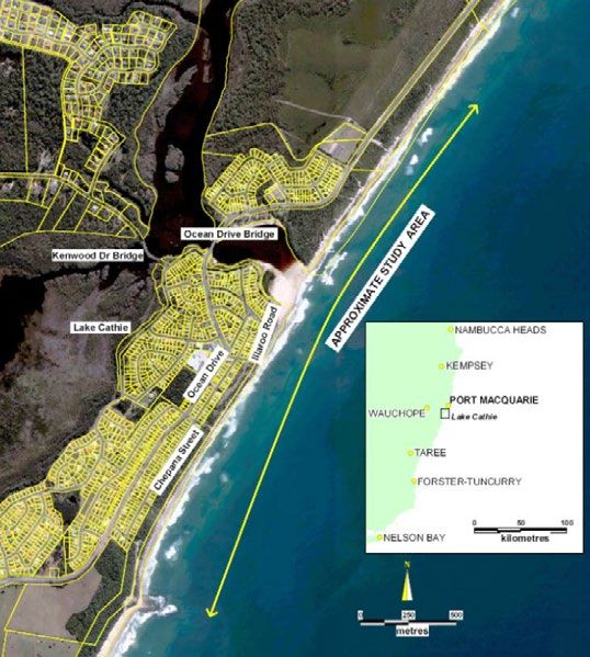
3 . G OV E R N A N C E

The CMP covers a large geographic area in the
PMHC LGA and lays over various land zones.
Within Council’s governance structure, the action
or manner of governing, there are multiple land
managers including the Natural Resources,
Recreation and Building, Strategic Planning, and
Infrastructure Planning sections that may all need
to be consulted before works may be undertaken.
In addition to internal consultation, numerous state
agencies including Department of Planning, Industry
and Environment, Department of Primary Industries
Fisheries, National Parks and Wildlife Services,
NSW Office of Water, Roads and Maritime, and
Crown Lands also own, regulate certain activities
and manage land within the coastal zone and must
be consulted with before works can occur. These
departments have governance decisions over
their land on which Council must seek permission
and licensing from before works are undertaken.
Other key stakeholders are the Local Aboriginal
Land Councils, which must be consulted and give
permission for works on land that is owned and
managed by the traditional owners of this land.

When discussing governance, it is also important
to remember to be a good neighbour and as such
when undertaking works near the LGA boundaries
of Kempsey and MidCoast Councils, further
discussions need to occur to manage the risks of
shared estuaries and sediment compartments.

Consultation will always be a key factor in
governance. One way to ensure Council is
making sound management decisions is PMHC’s
internal Coast, Estuary and Floodplain Advisory
(CE&F) Sub-Committee that is used for regular
review and consultation of policies, projects and
studies. Members of this committee consist of
representatives from PMHC Councillors, waterways
users, community members, development industry,
oyster industry, Council staff, Crown Lands, DPI –
Fisheries, NPWS, DPIE, TfNSW – Maritime division,
and SES.

                                                                                                                                          Figure 3. Rainbow Beach, Bonny Hills

  10          P O R T    M A C Q U A R I E - H A S T I N G S   C O U N C I L   C O A S T A L   M A N A G E M E N T   P R O G R A M   -   S T A G E       1              11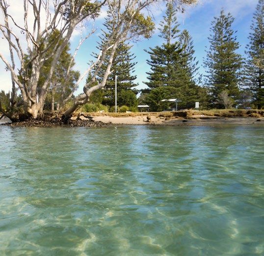
4 . P O R T M A C Q U A R I E - H A S T I N G S C OA S T A L Z O N E
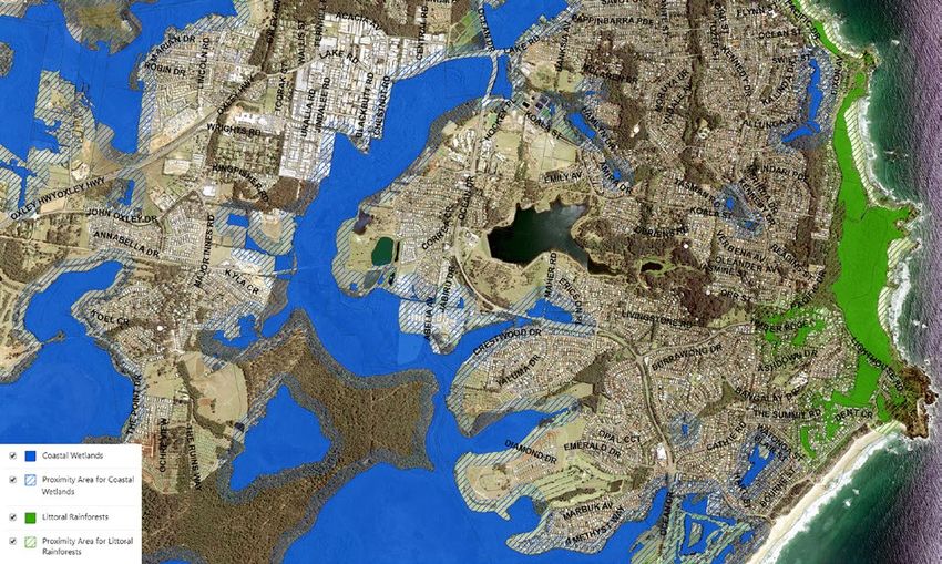
Figure 4. Example of Coastal Wetlands and
Littoral Rainforest map with proximity areas.
The Coastal Management Act 2016 defines the coastal zone as the area of land comprised within the coastal rainforest area includes a proximity area which is included in the definition. The proximity areas include land up
management areas i.e. coastal wetlands and littoral rainforests area, coastal vulnerability area, coastal to 100 metres area around the defined coastal wetlands and littoral rainforest area [see Figure 4].
environment area and coastal use area. The Coastal Management SEPP 2018 (CM SEPP) identifies these
areas and provides mapping for coastal wetlands and littoral rainforests area, coastal environment area and Coastal and estuaries within the LGA have historically been managed as separate areas i.e. EMP’s and
the coastal use area. The CM SEPP states that at the commencement of the policy, no coastal vulnerability CZMP’s. This same principle will be followed within the CMP in order to specify actions and determine priority
area was adopted and therefore this area has not been identified or mapped. areas. The following sections identify the Coastal Management Areas mapped or identified in the LGA in
context to each area as it applies i.e. estuary, coast or catchment (covering both).
The NSW State Government has generated mapping for the coastal wetlands and littoral rainforests area,
coastal environment area and the coastal use area. The mapping for the coastal wetlands and littoral
12 P O R T M A C Q U A R I E - H A S T I N G S C O U N C I L C O A S T A L M A N A G E M E N T P R O G R A M - S T A G E 1 13
5 . VA L U E S A N D R E S P O N S I B I L I T I E S

Council’s Community Strategic Plan (CSP) is an                                                                                                           Estuary and Floodplain Advisory Committee
overarching 10-year plan. It is prepared by Council                                                                                                      (including government agency representatives)
and the community based around community                                                                                                                 will be responsible to undertake broad community
priorities. The current CSP was prepared by                                                                                                              consultation. This consultation will focus on specific
Council in 2008 and subsequently reviewed and                                                                                                            geographical areas and will assist in identifying
updated in 2012 and 2016. The plan enables                                                                                                               important assets, issues, risks, solutions and the
Council to coordinate funding priorities, activities                                                                                                     values and priorities of the community.
and services to align to community needs and
desires. The CSP goals specifically for the                                                                                                              An overview of some of the identified community
Natural and Built Environment are to achieve a                                                                                                           values that will be used to guide the long-term
connected, sustainable, accessible community and                                                                                                         outcomes for the CMP are outlined below, Council
environment that is protected now and into the                                                                                                           welcomes more suggestions as we work through
future. Some of the key priorities of the CSP are:                                                                                                       the community engagement:
• A community that is prepared for natural events                                                                                                        • Unique coastal zone character
   and climate change.                                                                                                                                   • Amenities
• Sustainable and environmentally sensitive                                                                                                              • Public access
   development outcomes that consider the                                                                                                                • Equity and fairness
   impacts on the natural environment.                                                                                                                   • Water quality
• Infrastructure provision and maintenance that                                                                                                          • Biological diversity
   meets community expectations and needs.
                                                                                                                                                         • Ecosystem integrity and resilience
• Well planned communities that are linked to
   encourage and manage growth.                                                                                                                          • Recreational use
• Accessible and protected waterways, foreshores,                                                                                                        • Business/employment benefits
   beaches and bushlands.                                                                                                                                • Community benefits
• An environment that is protected and conserved
   for future generations.                                                                                                                               In addition to the broader community, Council is
                                                                                                                                                         also acutely aware of our neighbouring Councils as
Council is currently in the development of a new                                                                                                         we share estuaries and sediment compartments
Community Strategic Plan (CSP) “Think 2050”.                                                                                                             across our Council boundaries. The Camden Haven
This plan needs to be developed before June 2021                                                                                                         River Estuary and Tacking Point-Crowdy Head
to align with the state governments Integrated                                                                                                           sediment compartment is shared with Mid Coast
Planning and Reporting (IPR) framework.                                                                                                                  Council (MCC) and the Hastings River Estuary and
                                                                                                                                                         the South West Rocks-Port Macquarie sediment
How does the CSP affect the CMP?                                                                                                                         compartment is shared with Kempsey Shire Council
                                                                                                                                                         (KSC). The Coastal Management Act 2016 requires
In preparing the CMP, Council must integrate the
                                                                                                                                                         consultation with other local Councils where those
various planning documents and strategies that
                                                                                                                                                         Councils share a coastal sediment compartment or
affect the local community and the state. Being
                                                                                                                                                         estuary. As such, consultation will be undertaken
mindful that the CMP will become a reference tool
                                                                                                                                                         with neighbouring Councils specifically for those
for Council, the community, government agencies
                                                                                                                                                         actions that effect either a shared estuary or a
and other stakeholders, the document must be
                                                                                                                                                         shared sediment compartment.
practical, achievable and must integrate the actions
of the CMP into the larger scope of the Council in
order to manage the PMHC coastal zone.

As a way of both understanding the community
needs and wants as well as providing guidance
to the community regarding how the CMP works,
Council staff as well as members of the Coast,
                                                         Figure 5: Wildlife at Lake Cathie - Photo: Brett Dolsen

  14          P O R T    M A C Q U A R I E - H A S T I N G S    C O U N C I L                                      C O A S T A L   M A N A G E M E N T    P R O G R A M      -   S T A G E     1          15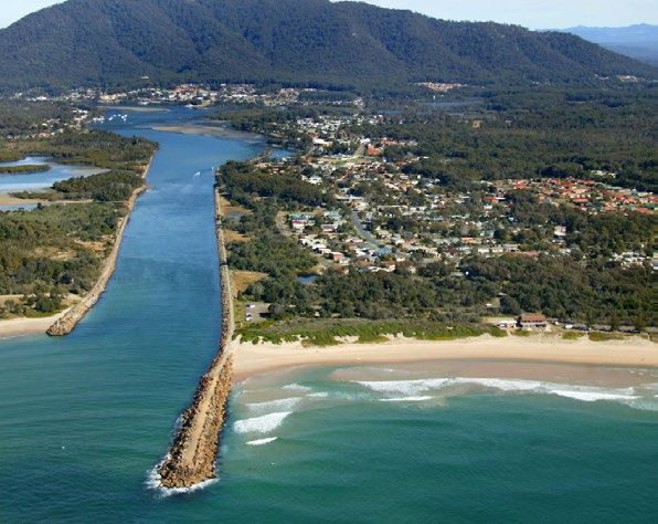
6. STRATEGIC CONTEXT

6.1 BACKGORUND                                                                                                      restore, enhance and conserve the environment of the area for which it is responsible, in a manner that is
                                                                                                                    consistent with and promotes the principles of ecologically sustainable development (ESD). The Council’s
NSW & Local Government have historically                   The NSW State Government undertook coastal               local government area extends to the beach foreshore, being the area between the high watermark and the
managed coasts and estuaries in accordance with            reforms in 2016. These reforms repealed the CP           low watermark. Therefore, Council is required to manage risk in the coastal zone such as foreshore erosion,
the following legislation:                                                                                          noting that it should be done so in accordance with ESD and in collaboration with other managing agencies,
                                                           Act and replaced it with the Coastal Management
                                                                                                                    i.e. Crown Land.
• Coastal Protection Act 1979 (CP Act)                     Act 2016 (CM Act).
• NSW Coastal Policy 1997 (NSW CP)                         The new framework for managing the NSW coast           6.3 EXISTING & FORMER MANAGEMENT PLANS
• State Environmental Planning Policy Coastal              primarily consists of:
   Wetlands No. 14 (SEPP 14)                               • Coastal Management Act 2016 (CM Act)                 6.3.1. COASTAL ZONE MANAGEMENT PLANS
• State Environmental Planning Policy Littoral             • State Environmental Planning Policy (Coastal
   Rainforests No. 26 (SEPP 26)                               Management) 2018 (CM SEPP)                          The Coastal Protection Act 1979 & Coastal Policy suggested that Councils develop and implement Coastal
• State Environmental Planning Policy Coastal              • NSW Coastal Management Manual (Manual).              Zone Management Plans (CZMPs) to manage their coastlines. CZMPs were intended to provide management
   Protection No. 71 (SEPP 71)                             • Coastal Management Programs (CMPs)                   guidance for coastal zones including understanding coastal processes and how the coastal zones were used.
• NSW Rivers and Estuaries Policy (NSW EP)                 • NSW Coastal Council                                  For detailed information on existing CZMPs and EMPs refer to Chapter 16 of this scoping study.

                                                                                                                  The following CZMPs were developed:
A CMP is being developed which will provide integrated management of defined coastal areas within the Port
                                                                                                                  • Town Beach Coastal Zone Management Plan (2006). NB. This CZMP was not gazetted as it was not certified
Macquarie-Hastings Local Government Area and will replace existing Coastal Zone Management Plans (CZMP)             by the NSW state government.
and Estuary Management Plans (EMP) once implemented.                                                              • Lake Cathie Coastal Zone Management Plan (2016). NB: This CZMP was gazetted on 27 January 2017.
The Manual provides guidance on the development of CMPs and divides the development into five (5) stages,
                                                                                                                  6.3.2. ESTUARY MANAGEMENT PLANS
with Stage 1 being a scoping study [see section 1.1].
                                                                                                                  The NSW Rivers and Estuaries Policy required Councils to develop EMPs in order to achieve integrated,
6 . 2 H I S T O R I C A L C O A S TA L M A N A G E M E N T F R A M E W O R K                                      balanced, responsible and ecologically sustainable use of estuaries which formed a key part of coastal
The coastal zone has historically been managed in accordance with the following legislation.                      catchments.
• Coastal Protection Act 1979 (CM Act 1979): Required Council’s to develop CZMPs.                                 The following EMPs were developed:
• NSW Coastal Policy 1997 (CP 1997): This policy provided overarching direction for Council in its                • Lake Cathie-Lake Innes Estuary Management Plan (1994)
  preparation and implementation of its CZMP.
                                                                                                                  • Hastings River Estuary Management Plan (2001)
• State Environmental Planning Policy Coastal Wetlands No. 14 (SEPP 14): This policy provided restriction
  for development on certain types of land to ensure the protection of coastal wetlands. This SEPP is now         • Camden Haven River Estuary Management Plan (2002)
  repealed and has been replaced with the Coastal Management SEPP.                                                • Saltwater Creek Management Plan (2005)
• State Environmental Planning Policy Littoral Rainforests No. 26 (SEPP 26): This policy provided restriction
  for development on certain types of land to ensure the protection of littoral rainforests. This SEPP is now     6.3.3. FLOODPLAIN MANAGEMENT PLANS
  repealed and has been replaced with the Coastal Management SEPP.
• State Environmental Planning Policy Coastal Protection No. 71 (SEPP 71): This policy provided                   Councils also have a role managing floodplain risk. Although these plans coincide with the same geographical
  considerations and development conditions on coastal land to ensure developments are suitable and do not        area as the coastal zone at times, these management plans are still in effect. No changes in legislation or
  impact on the land. This SEPP is now repealed and has been replaced with the Coastal Management SEPP.           policy have altered these plans.
• Environmental Planning and Assessment Act 1979 (EPA Act): This Act required Council to consider the
  suitability of the site in assessing proposed development including considering the risks of coastal hazards.   The following floodplain risk management plans have been developed and are still in effect:
  It also requires the consideration of the principles of ecologically sustainable development, being an object   • Camden Haven Floodplain Risk Management Plan, Bewsher Consulting Pty Ltd, 2004
  to the EPA Act. A further section regulating the management of coastal hazards was s149 of the EPA Act,         • Hastings Floodplain Risk Management Plan, Worley Parsons Services Pty Ltd, 2014
  which assisted those applying for a s149 certificate to understand what policies affected the land by
  restricting development, as well as other relevant matters affecting the land.                                  6.3.4. OTHER MANAGEMENT PLANS
• Environmental Planning and Assessment Regulation 2000: Clause 92 of this Regulation required Council
  to consider the provisions of the CP 1997 when determining development applications within a coastal            There are a large number of reserves located in the coastal zone that PMHC manages using Masterplans and
  zone.                                                                                                           Plans of Management. [See section 16.2.5] for other Plans and Reports for further information.
• NSW Rivers and Estuaries Policy (NSW EP): This policy encompassed a suite of component policies each
  focussing on the protection or management of ecosystem processes and associated values. It also provided
  for clear management objectives and principles to reflect the State’s commitment to resource sustainability.
• Local Government Act 1993 (LG Act): This Act requires Council to properly manage, develop, protect,

  16          P O R T    M A C Q U A R I E - H A S T I N G S       C O U N C I L                                                    C O A S T A L    M A N A G E M E N T      P R O G R A M      -   S T A G E   1         17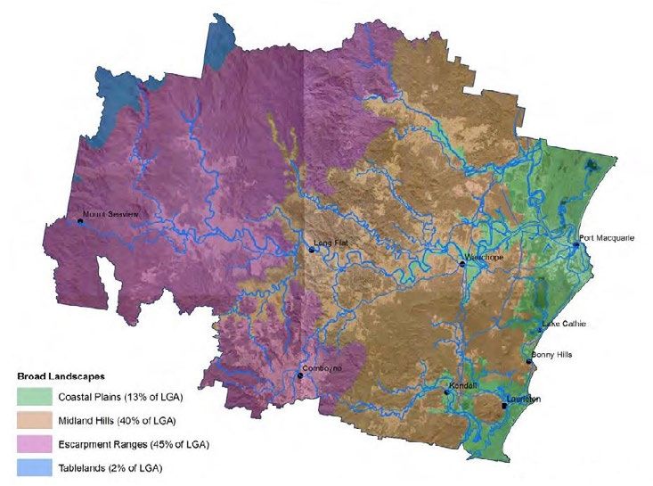
7 . N E W C OA S T A L M A N A G E M E N T F R A M E WO R K

7 . 1 C O A S TA L M A N A G E M E N T A C T 2 0 1 6                                                               7 . 2 S TAT E E N V I R O N M E N TA L P L A N N I N G P O L I C Y ( C O A S TA L M A N A G E M E N T )
                                                                                                                   2018
The CM Act establishes the framework and overarching objects for coastal management in New South Wales.
                                                                                                                   The State Environmental Planning Policy (Coastal Management) 2018 (CM SEPP) identifies and maps the
The purpose of the CM Act is to manage the use and development of the coastal environment in an                    coastal zone according to definitions in the CM Act and aims to streamline coastal development assessment
ecologically sustainable way, for the social, cultural and economic well-being of the people of New South Wales.   requirements.

The CM Act also supports the aims of the Marine Estate Management Act 2014, as the coastal zone forms              The CM SEPP identifies development controls for consent authorities to apply to each coastal management
part of the marine estate.                                                                                         area to achieve the objectives of the CM Act. And as such, the CM SEPP establishes the approval pathway for
                                                                                                                   coastal protection works.
The CM Act defines the coastal zone, comprising four (4) coastal management areas:
• Coastal wetlands and littoral rainforests: areas which display the characteristics of coastal wetlands or        Statewide mapping is available for:
  littoral rainforests that were previously protected by SEPP 14 and SEPP 26.                                      • Coastal wetlands and littoral rainforest area
• Coastal vulnerability area: areas subject to coastal hazards such as coastal erosion and tidal inundation.       • Coastal environment area
• Coastal environment area: areas that are characterised by natural coastal features such as beaches, rock         • Coastal use area
  platforms, coastal lakes and lagoons and undeveloped headlands. Marine and estuarine waters are also
  included.                                                                                                        At the commencement of the CM SEPP, no Coastal Vulnerability Area Maps were adopted and therefore no
• Coastal use area: land adjacent to coastal waters, estuaries and coastal lakes and lagoons.                      coastal vulnerability areas are identified in this policy.

The CM Act establishes management objectives specific to each of these coastal management areas,
                                                                                                                   7 . 3 C O A S TA L M A N A G E M E N T P R O G R A M S
reflecting their different values to coastal communities.
                                                                                                                   CMPs will set the long-term strategy for coordinated management of the coast with a focus on achieving the
Different management objectives exist across the four coastal management areas. New maps defining
                                                                                                                   objects of the CM Act. Local Councils in consultation with their communities and relevant public authorities
the coastal management areas were released with the commencement of the Coastal Management SEPP.
                                                                                                                   prepare them. Councils are not required to develop a CMP if they choose not to.
If multiple areas apply to a single parcel of land, the CM Act imposes a hierarchy as to which coastal
management objectives apply.                                                                                       If a CMP is proposed, it must:
                                                                                                                   1. Identify the coastal management issues affecting the areas to which the program is to apply
A Coastal Management Manual has been developed as part of the reform package. The manual contains the
                                                                                                                   2. Identify the actions required to address those coastal management issues in an integrated and strategic
mandatory requirements which must be imposed when developing Coastal Management Programs (CMPs).
                                                                                                                       manner
The Act has abolished the NSW Coastal Panel, and established a new NSW Coastal Council.                            3. Identify how and when those actions are to be implemented
                                                                                                                   4. Identify the costs of those actions and proposed cost-sharing arrangements and other viable funding
TRANSITION FROM OLD TO NEW                                                                                             mechanisms for those actions
                                                                                                                   5. Include a coastal zone emergency action sub-plan if the local Council’s LGA contains land within the coastal
The Act has introduced CMP’s to replace the Coastal Zone Management Plans (CZMPs) that were implemented                vulnerability area and beach erosion, coastal inundation or cliff instability is occurring on that land.
under the Coastal Protection Act 1979. Council’s must have new CMPs in place and adopted before works can
qualify for grant funding. As part of the legislation change no transition arrangements were provided meaning      A CMP may also include other matters as may be authorised or permitted by the Manual.
all existing Council adopted Estuary Management Plans are now no longer capable of receiving grant funding.

Hence until a CMP is adopted, no estuary management works will be funded by the NSW State Government.
Coastal management works that are contained within a certified CZMP are still eligible for funding, but only
until December 2021.

Estuary management works have not been capable of receiving NSW state government grant funding since
April 2018 which has significantly impacted on Council’s ability to undertake estuary management works.

  18          P O R T    M A C Q U A R I E - H A S T I N G S       C O U N C I L                                                     C O A S T A L     M A N A G E M E N T      P R O G R A M     -   S T A G E    1          19
7 . 4 N S W C O A S TA L M A N A G E M E N T M A N U A L 7 . 6 C O A S TA L A N D E S T U A R Y G R A N T S P R O G R A M
The Manual provides mandatory requirements and guidance for the preparation, development, adoption, The Coastal and Estuary Grants program provides funding assistance to help Councils prepare and implement
implementation, amendment and review of CMPs. CMPs. Funding has historically been provided for planning and implementation works at a ratio of 1:1, meaning
for every one-dollar Council commits, the NSW government will provide a matching one-dollar.
It provides systematic guidance on how to prepare a CMP and integrate coastal management actions with
Councils other strategic and land-use planning processes. In April 2020 the NSW Government announced that it was increasing financial assistance to Councils to help
mitigate coastal erosion risks and restore degraded coastal habitats.
The Manual is comprised of three parts:
Minister for Local Government Shelley Hancock said the funding ratio for eligible projects under approved
Coastal Management Programs will increase to 2:1 meaning the State will now contribute two-dollars to every
PA R T A PA R T B PA R T C
one-dollar put in by Councils.
Outlines the mandatory Describes in detail the process Provides a technical toolkit with
requirements in the CM Act, for preparing a CMP. advice on a range of topics. These changes are part of 32 supported recommendations from a recent review that examined ways of
and the essential elements that
improving Councils access to funding under the Coastal and Estuary Management program.
councils are required to follow.
The 2:1 funding ratio will bring the Coastal & Estuary Management grants program in line with the Floodplain
7 . 5 N S W C O A S TA L C O U N C I L Management Grants Program.
The NSW Coastal Council is appointed by the NSW Government to provide independent advice to the Minister The 2:1 funding ratio is only applicable to planning and implementation projects where they are in an approved
on coastal issues. The NSW Coastal Council replaces the NSW Coastal Panel and the Coastal Expert Panel. CMP, as such the action items from the certified Lake Cathie CZMP are not eligible for 2:1 funding and will only
be able to access funding from the NSW Government at a 1:1 ratio.
Current Coastal & Estuary Grant Program funding is only available until the end of the 2020/2021 financial
year. Grant funding arrangements after this time are unknown.
Figure 6. Oxley Beach, Port Macquarie
20 P O R T M A C Q U A R I E - H A S T I N G S C O U N C I L C O A S T A L M A N A G E M E N T P R O G R A M - S T A G E 1 218 . C O U N C I L S S T R A T E G I C P L A N N I N G F R A M E WO R K
8 . 1 S T R AT E G I C P L A N S Under the framework, councils are required to give due regard to State Plan NSW 2021 and other Relevant
Regional Plans to inform Council in identifying relevant issues for its Community Strategic Plan. Likewise,
PMHC is guided by a number of key strategies and plans which will assist with integrating the aspects of Council also have a wide range of plans for consideration, which highlight key local community issues. A
population growth, land use, community values and expectations into the CMP. These strategies and plans are number of examples include Coastal Management Programs, Urban Growth Management Strategy, Economic
summarised below. Development Strategy, Recreation Action Plan, Biodiversity Strategy, and Cultural Plan.
INTEGRATED PLANNING AND REPORTING FRAMEWORK
(IP&R)
The Integrated Planning and Reporting (IPR) framework was
legislated by the New South Wales Office of Local Government Other State Plans State Plan Relevant Regional
in 2009. It provides councils with a planning framework that and Strategies NSW 2021 Plans
is guided by the vision of the community for a 10 year period
and gives local governments a structure for establishing local
priorities and to link this information to operational functions. Community Local Strategic
Strategic Plan Planning
The framework includes a suite of integrated plans that set
10+ years Statement
out a vision and goals and strategic actions to achieve them. It
20+ years
involves a reporting structure to communicate progress to council
and the community as well as a structured timeline for review to
ensure the goals and actions are still relevant.
Other Strategic Plans
The framework is made up of four major elements, which are e.g. Coastal e.g. Urban e.g. e.g. e.g.
Management Growth Recreation Biodiversity Economic
linked and continually assessed through regulatory reporting Programs Management Action Plan Strategy Development
Strategy Strategy Resourcing
channels.
Strategy
These are the: Community > Long Term
Delivery Program Financial Planning
• Towards 2030 Community Strategic Plan (CSP) 2017-2021 Engagement 4 years > Workforce Management
Planning
• Delivery Program (DP) (Revised) > Asset Management
• 2020-2021 Operational Plan (OP) Operational Plan
Planning
• Resourcing Strategy (RS) 1 year
Perpetual
Monitoring
& Review
Annual
Report
Figure 7. Integrated planning and reporting framework
22 P O R T M A C Q U A R I E - H A S T I N G S C O U N C I L C O A S T A L M A N A G E M E N T P R O G R A M - S T A G E 1 23NORTH COAST REGIONAL PLAN 2036 TOWARDS 2030 COMMUNITY STRATEGIC PLAN 2017
The North Coast Regional Plan 2036 is a broad strategic plan that reflects The CSP identifies what the community wants for the future
the community’s aspirations and opportunities for the north coast of NSW of the LGA and what should be prioritised. This plan should
until 2036. be reviewed every 10 years and is the overarching guidance
for Councils strategic direction. The Delivery Program and
the Operational Plan are the underlying plans of the CSP,
which provide more detailed targets and actions to be
MID NORTH COAST REGIONAL STRATEGY 2006 - 2031 delivered and how they can be achieved.
The Mid North Coast Regional Strategy 2006 – 2031 was released by NSW The CMP must consider the strategic direction of the
Department of Planning in March 2009. The primary purpose of the regional Community Strategic Plan to ensure that it coincides with
strategy is to ensure that adequate land is available and appropriately located what the community wants for the LGA. This will then have to
to accommodate projected housing and employment needs of the region’s be integrated into the Delivery and Operational Plans once specific actions are determined.
population over the next 25 years.
PMHC’s Towards 2030 Community Strategic Plan (CSP) for the natural and built environment aims “to achieve
In summary the aims of the strategy are to: a connected, sustainable, accessible community and environment now and into the future”. The results of the
• Protect high value environments and habitat corridors, cultural and CSP will be:
Aboriginal heritage and scenic landscapes. • Effective management and maintenance of essential water, waste and sewer infrastructure
• Provide up to 58,400 new homes by 2031 to cater for a forecast • A community that is prepared for natural events and climate change
population increase of 91,000. With smaller households and an ageing
• Sustainable and environmentally sensitive development outcomes that consider the impact on the natural
population, a more suitable mix of housing will be encouraged, including
environment
more multi-unit style dwellings.
• Accessible transport network for our communities
• Ensure an adequate supply of land is available to support economic
growth and an additional 47,000 jobs. • Infrastructure provision and maintenance that meets community expectations and needs
• Encourage the growth and redevelopment of the Region’s four major • Well planned communities that are linked to encourage and manage growth
regional centres (Grafton, Coffs Harbour, Port Macquarie and Taree) and • Accessible and protected waterways, foreshores, beaches and bushlands
six major towns (Maclean, Woolgoolga, Bellingen, Macksville, Kempsey • An environment that is protected and conserved for future generations
and Forster–Tuncurry) through urban design and renewal strategies.
• Renewable energy options that are understood and accessible by the community
• Protect the coast by focusing new settlement in areas identified on local
strategy maps. Development in places constrained by coastal processes, PMHC continues to look to the future and therefore has already begun preparing the “Think 2050 CSP” which
flooding, wetlands, important farmland and landscapes of high scenic and will supersede the current CSP when completed.
conservation value will be limited.
THINK 2050 COMMUNITY STRATEGIC PLAN
PMHC URBAN GROWTH MANAGEMENT STRATEGY
(UGMS) 2017-2036 Port Macquarie-Hastings Council launched the Think 2050 Community
Strategic Plan and commenced community engagement on 4 December
The PMHC UGMS aims to identify opportunities for new
2019.
economic development and housing that will meet the needs
of the growing community. The Community Vision for the Port Think 2050 is centered on engaging with everyone in our community
Macquarie-Hastings is “A sustainable high quality of life for including those that live, work, study, attend school or do business, as well
all”. The strategy focuses on the coastal area and major as those that shop or visit our beautiful region.
towns and villages where urban growth is expected to take
place over the next 20 years. Throughout 2020 and the first half of 2021 Council will be engaging with
community members and asking for ideas, suggestions, and feedback to
help plan for the ongoing and future needs of the region. These findings will
be incorporated into the CMP as they develop.
24 P O R T M A C Q U A R I E - H A S T I N G S C O U N C I L C O A S T A L M A N A G E M E N T P R O G R A M - S T A G E 1 259 . P O RT M AC QUA R I E - H A S T I N G S L G A 0 V E RV I E W
The mouth of the Hastings River is located at Town Beach Port Macquarie while the Camden Haven River
comes out between North Haven and Dunbogan. The Lake Cathie/Lake Innes catchment does not have a
major river feeding the system, but instead is fed by a number of small creeks that flow into both lakes. Lake
Figure 8. Port Macquarie-Hastings LGA in relation to NSW (Nearmap, n.d.7
Cathie is an Intermittingly Closed and Open Lake or Lagoon (ICOLL) meaning it does not permanently have
open access to the ocean.
The Port Macquarie-Hastings LGA has a remarkable coastline extending from Point Plomer in the north to
Diamond Head in the south [see Figure 12]. There are numerous beaches in the LGA and among some of
the finest in the state, offering a mixture of fine sandy shores, rocky headlands and rainforests. Some of the
most visited beaches include Town Beach (Port Macquarie), Lighthouse Beach (Port Macquarie to Lake Cathie)
and Shelly Beach (Port Macquarie). Other notable beaches include Rainbow Beach (Bonny Hills), North Haven
Beach, Middle Rock Beach (Lake Cathie) and Pilot Beach (Dunbogan).
TELEGRAPH
PORT MACQUARIE-HASTINGS POINT
LOCAL GOVERNMENT AREA
The Port Macquarie-Hastings LGA is located on the
Mid-North Coast of NSW, about 320 kilometres
north of Sydney, 420km south of Brisbane, QLD
and has an area 3,687 km2 [Refer to Figure 8]. Pappinbarra PORT
Significant localities situated on the coast in the MACQUARIE
LGA are North Shore, Port Macquarie, Lake Cathie, Long Flat
Bonny Hills, North Haven, Dunbogan and Laurieton. Sancrox
Beechwood
Port Macquarie is the most populous and attracts Ellenborough
most of the coastal activity, especially activities WAUCHOPE Thrumster
related to tourism.
There are three main catchments in the LGA:
the Hastings River, Lake Cathie/Lake Innes Byabarra
and the Camden Haven [see Figures 9, 10 and
11]. The Hastings River is the largest of all LAKE CATHIE
these catchments and encompasses an area of
3,864km2. The river itself is 165km long and is BONNY HILLS
the source of the majority of the LGA’s drinking
water supply which is pumped from Koree Island, Comboyne
upstream of Wauchope. NORTH HAVEN
Kendall
Kew
LAURIETON
Lorne DUNBOGAN
* This map is not to scale
Figure 12. Port Macquarie-Hastings LGA showing coastal areas
Figure 9. Hastings River from Koree Island Figure 10. Lake Cathie looking west Figure 11. Camden Haven River looking towards
North Brother mountain
26 P O R T M A C Q U A R I E - H A S T I N G S C O U N C I L C O A S T A L M A N A G E M E N T P R O G R A M - S T A G E 1 2710. ENVIRONMENTAL CONTEXT
1 0 . 1 C L I M AT E Since 2000 there have been significant fires in Limeburners National Park (2002, 2010), Christmas Bells
Plains (2002), Bonny Hills (early 2000’s), Dunbogan (2005) and Pappinbarra (2017, 2019).
The PMH LGA is located in the subtropical region of Australia where it experiences a warm temperate climate.
Summers are moderately warm and humid with coastal storms often occurring in the evening during the later Bushfires can have various impacts on waterways both during and post fires. The key contaminants of concern
summer months. Winters are generally mild with frosts often occurring in the inland areas. for managers include increased suspended solids and turbidity, increased nutrients, increased risk of toxic
algal blooms and increased metal concentrations. Fire also increases the potential for runoff and erosion as
Weather data sampled at the Port Macquarie Airport shows the mean maximum temperature is 23.8° C and well as unburnt organic matter washing into waterways and reducing dissolved oxygen as it decomposes.
the mean minimum temperature is 12.7° Celsius. The mean annual rainfall for the LGA varies depending on
proximity to the coast and the higher peaks inland. Generally speaking, the mean annual rainfall for the LGA is Figure 13. Bushfire map depicting burnt land in the Port Macquarie area during 2019-20
approximately 1500mm.
As is the rest of NSW and Australia, PMHC is prone to experiencing prolonged droughts with significantly less
than average rainfall occurring throughout the region at times. This leads to lower river levels and increased
bushfire intensity and frequency.
1 0 . 2 S I G N I F I C A N T C L I M AT I C E V E N T S
PMHC experiences a number of coastal storm events with the latest significant event being the East Coast
Low of June 2016. This event included strong north-easterly winds (gusts up to 120km/h) with the highest
individual wave recorded on the NSW coast of 17.7m at Eden (BOM, Manly Hydraulics Laboratory and OEH,
2016). This event occurred at the same time as the winter solstice spring tide and significant rainfall which
both compounded the erosive damage and storm debris to PMHC’s coast.
PMHC has experienced some major flood events (1963 and 1968) as well as more frequent relatively minor
events (1978, 1995 and 2013). The 1963 flood was the worst in the lower catchments (Hastings & Camden
Haven) due to high ocean conditions. This was estimated to be a “1 in 100-year” event and anecdotally the
worst Wrights Creek flood recorded. The 1968 flood was also estimated to be a “1 in 100-year” event and
mostly affected the upper catchments due to high rainfall. The 1978, 1995 and 2013 Hastings River floods
were all approximately “1 in 20 year” events.
Drought has affected most of New South Wales since early 2017 and in 2019 the PMH LGA experienced its
lowest recorded amount of annual rainfall (514mm) since 1870. The rainfall deficiencies contributed to the
stoppage of water flow in the Hastings River which meant that PMHC and private landholders were unable to
extract water for domestic and irrigation purposes from the system. This also led to heavy water restrictions
being placed on the local community by PMHC. The Lake Cathie/Innes estuarine system was also adversely
affected by the ongoing drought conditions. Council last artificially opened the lake entrance in July 2018
as the lake reached 1.6m AHD and began affecting properties that are susceptible to nuisance flooding.
Post opening, a lack of rainfall and small depositional waves naturally closed the entrance and with high
temperatures and high evaporation rates following the closure, the lake dropped to very low levels. The lowered
water levels within the system exposed extensive foreshore areas comprising ASS, caused elevated water
temperatures, low dissolved oxygen levels, hypersalinity and fish kills, therefore highlighting the need to review
the Entrance Opening Strategy.
During the extraordinarily damaging bushfire season of 2019-20 approximately 140,000 Ha of land was
burned within the PMH LGA. This included 3,572 Ha around the Lake Innes Nature Reserve south to Lake
Cathie and around the Queens Lake Conservation Area [refer to Figure 13]. There has been considerable
debate regarding the underlying cause of the intensity and scale of the recent fires, including the role of fire
management practices and climate change. Bushfires however, are not new to the area, major bushfire events
being experienced in the past.
28 P O R T M A C Q U A R I E - H A S T I N G S C O U N C I L C O A S T A L M A N A G E M E N T P R O G R A M - S T A G E 1 291 0 . 3 P H Y S I C A L F E AT U R E S A N D Despite this, erosion of the sand dune happens often after storm events and the close proximity of privately
C O A S TA L P R O C E S S E S owned houses and public assets to the shoreline means it requires management. Town Beach is the main
beach in the LGA. While there are no residential properties under threat, there are a number of assets such
The coastline is subject to a high energy wave as roads and park infrastructure that are exposed to this risk. Flynns Beach is one such beach that contains
climate. The offshore swell wave climate (wave assets that are exposed to risks, which has been confirmed via coastal hazard studies. The existing sea wall
height, period and direction occurrences) has been is not adequate in protecting the assets behind the beach, so a new sea wall is required. The first stage of the
recorded by the NSW Government Manly Hydraulics sea wall replacement has occured at Flynn’s beach which now protects the surf club, kiosk, road access and
Laboratory with Waverider buoys located at Sydney, open space reserve. Other beaches where erosion has been identified, though not studied, are Rainbow Beach,
Crowdy Head and Coffs Harbour for many years. The Shelly Beach, North Shore Beach (Corilla Estate) and Dunbogan Beach. These are areas where investigations
wave data show that the predominant swell wave will be considered during the CMP process.
direction is south-southeast (SSE) with over 70% Figure 14. Town Beach East Coast Low event June 2016 (before and
during)
of swell wave occurrences directed from the SSE. 1 0 . 4 S E D I M E N T C O M PA R T M E N T S
The average deep-water significant wave height is
measured at 1.6m with the average wave period Coastal sediment compartments are defined areas that have similar coastal processes and are based on
being 10 seconds as recorded at Crowdy Head sediment flows and landforms.
(SMEC, 2008).
The Australian Government initiated the Coastal Compartments Project which aimed to establish a consistent
East Coast Lows (ECLs) have occurred in the area approach in managing Australia’s coastline (Thom, N.D.). This project resulted in sediment compartments
causing coastal erosion and washing up of debris. being mapped along Australia’s entire coastline. These sediment compartments are divided into three levels:
One large event was recorded in June 2016 [see • Primary level defined by large landforms e.g. headlands and rivers
Figures 14 to 17 to the right]. ECLs are intense • Secondary level defined by sediment movement within and between beaches
low-pressure systems that occur off the east coast • Tertiary level where sediment moves in the nearshore area e.g. individual beaches
of Australia. They can form at any time of the year
and significant ECLs occur on average about 10 Figure 15. And after looking east towards Kiosk PMHC shares two coastal sediment compartments with neighbouring Councils that are defined as secondary
times each year. These storms can have severe level compartments. The South West Rocks-Port Macquarie sediment compartment [see Figure 18] is shared
consequences in terms of wind damage, storm with KSC and the Tacking Point-Crowdy Head sediment compartment [see Figure 19] is shared with MCC. These
surge, heavy and damaging surf and flash flooding sediment compartments are identified in Schedule 1 of the CM Act.
(AdaptNSW). Climate modelling projects a decrease
in the number of small to moderate ECLs in the cool
season with little change in these storms during the
warm season. However, extreme ECLs in the warmer
months may increase in number but extreme ECLs in
cool seasons may not change.
The open coastline is made up of sandy beaches
and rocky headlands with significant portions of
Figure 16. Lake Cathie East Coast Low Event June 2016. Pictured at
the coastline made up of the Coastal Wetland and intersection of Kalang Drive and Bundella Avenue, Lake Cathie. Left
photo taken 8 September 2015 and right photo taken 26 July 2016.
Littoral Rainforest Area (CWLRA), and National Parks.
Parts of the coast are susceptible to coastal erosion,
in particular, Town Beach and Lake Cathie Beach
(Lighthouse Beach). For example, a conservative
estimate of future long term recession of 0.20 m/
year was adopted for the beach at Lake Cathie
(Coastal Hazard Study, SMEC 2010).
Lighthouse Beach at Lake Cathie is comprised of
underlying consolidated or indurated sands (coffee
rock) which is more resistant to erosion than typical Figure 18. South West Rocks-Port Macquarie sediment compartment Figure 19. Tacking Point-Crowdy Head sediment compartment
unconsolidated beach sand. (Geoscience Australia, 2016) (Geoscience Australia, 2016)
Figure 17. Lake Cathie East Coast Low Event June 2016 - during early
and later phases of event, looking south along Illaroo Road.
30 P O R T M A C Q U A R I E - H A S T I N G S C O U N C I L C O A S T A L M A N A G E M E N T P R O G R A M - S T A G E 1 31You can also read