Supplement to April 2021 Draft Expanded Environmental Notification Form Nauset Estuary Dredging Project for Towns of Orleans & Eastham, MA
←
→
Page content transcription
If your browser does not render page correctly, please read the page content below
Supplement to April 2021 Draft Expanded Environmental Notification Form
     Nauset Estuary Dredging Project for Towns of Orleans & Eastham, MA

The following document provides supplemental information to the Draft Expanded Environmental
Notification Form (EENF) prepared for the Towns of Orleans and Eastham for the Nauset Estuary
Dredging project. The April 2021 Draft EENF was sent to the Towns of Orleans and Eastham for review
and comment prior to formally filing with the Massachusetts Environmental Policy Act (MEPA) Unit. A
copy of the Draft EENF can be found on the Towns web sites by using the following links:

        https://www.town.orleans.ma.us/select-board/pages/nauset-estuary-dredging-project

        https://www.eastham-ma.gov/select-board/pages/nauset-estuary-dredging-project

The following document provides supplemental information to the Draft EENF in response to questions
and comments received from Town staff, Select Boards, and members of the Nauset Estuary
Stakeholders Group. Public forums are currently scheduled for June 22 and 29, during which additional
questions and comments will be addressed. Prior to filing with MEPA at the end of July, and as
appropriate, the EENF will be revised to include the supplemental information included in this
document.

Sediments

    1. Sediment dredged from the Town Cove and Eastern Main Channel areas is planned for
       mechanical dredging with offloading to trucks at Goose Hummock public landing. Where will be
       sediment be trucked to?

Response: The proposed dredge material from Town Cove and the Eastern Main Channel is
predominantly sand with some silt (i.e., clean silty sand). As such, the material is suitable for beneficial
reuse as beach nourishment; however, the dredge areas are too far from available beaches using a
conventional hydraulic pipeline dredge so mechanical dredging was identified as the best method of
dredging. The sediment also has elevated red tide cyst concentrations and is not suitable to be pumped
directly onto a beach for nourishment purposes. Several materials handling facilities on Great Western
Rd. in South Dennis have been identified that can take the material. The South Dennis sites are
permitted to take dredged materials and will be listed as potential disposal locations on the Nauset
Estuary permit applications.

    2. Sediments from the Priscilla and Mill Pond channels that are proposed for dune enhancement at
       the north end of Nauset Beach are not compatible with the existing dunes because they have a
       higher percentage of fine-grained material than the dunes.

Response: Sediment cores collected from the Priscilla channel show layering, with finer-grained material
near the surface and coarser-grained sandy material below (EENF Section M). The cores also show
coarser-grained sandy material in the northern portion of the Priscilla channel and more fine-grained
material towards the south end of the channel. Grain size data for composited sediment samples (i.e.,
mixture of entire sediment core) show percentages of fines ranging from 10% in the north end of the
channel to 21% in the south end of the channel. The remaining sediment is medium to fine-grained
sand. These composited sample results are representative of what will be deposited in the dewatering
basin. During dredging the sediments will be combined into a homogenous mixture of sediment
containing between 79% and 90% sand and 21% to 10% fines.

Coastal dunes typically contain finer-grained sediments than coastal beaches and high energy marine
environments. However, these Nauset Estuary dredged sediments are somewhat finer than the existing
dunes at the dewatering site, which have less than 1% fine-grained material. The project calls for the
finer-grained dredged sediment to be buried in the core of the dune where it will help to add resiliency
to the dune landform. The dredged sediments will also be covered with 1-3 ft of native dune sediment.
For this application, the slightly finer dredged material be used to add to the overall dune volume and
elevation, which will improve the natural storm damage protection features of the resource.

Sediment cores from the Mill Pond channel are being collected this summer (summer 2021). The
proposed channel extends from the Priscilla channel to the entrance of Mill Pond and does not extend
into the deeper parts of the Pond where fine-grained sediments are known to occur. The current
assumption is that the Mill Pond sediments in the dredge channel are similar to the Priscilla channel
sediments and that the dredged material will be suitable for disposal in the dewatering basin. If the
sediment cores show higher percentages of fines, it will be necessary to identify an alternate disposal
location or make modifications to the channel design to avoid dredging the finer-grained sediments.

Channel Design

    3. A 100-ft wide channel behind the barrier beach is not needed for safety and will have negative
       impacts on stability of barrier beach and will increase the area of impact.

Response: The project team has spoken with emergency first responders and members of the Fire Dept
in Eastham and Orleans. Everyone expressed the need for a safe and navigable channel to ensure that
emergency first responders can reach commercial and recreational boaters in distress, regardless of
tide, day or night. Both Towns have and continue to work to address safety issues in the estuary. The
Town of Eastham purchased additional watercraft that can be used to respond to incidents, and they
also adjust the channel markers as needed and establish no wake zones. The Town of Orleans also has
watercraft that is used to respond to emergency situations in the estuary. Records of emergency
response incidents from both towns since 2016 show between 4 and 11 incidents per year in the estuary
(Appendix A).

To evaluate the potential for dredging to adversely impact the stability of the barrier beach, the project
team looked at changes in geomorphology (i.e., shape, size, location) of the barrier over the past 240
years. Figures D-1 and D-2 in the Draft EENF shows that the barrier follows a pattern of northerly
growth punctuated by periods of inlet breaching to the south. Figure D-2 shows northerly migration
between 1938 and 1994. A new inlet formed to the south in 1994 and for several years there were two
(2) inlets. By 2001 the northern inlet closed, and the estuary was connected to the Atlantic by one (1)
inlet. Since this time the barrier and inlet have steadily migrated to the north.
Westerly migration of the barrier beach and changes in the width of the barrier beach over the past 20
years were also evaluated during development of the Draft EENF. Figure D-3 of the EENF shows the only
place with significant western migration of the barrier into the estuary is just north of Nauset Heights
near the end of the Priscilla channel. The large overwash feature in this area has caused the barrier to
widen and expand into the estuary. All other areas of the barrier so little to no rollover, or migration to
the west. Figure D-4 in the Draft EENF shows changes in the width of the barrier beach from 2014 to
2019. The data show some narrowing of the barrier beach caused primarily by erosion along the ocean
side of the barrier, rather than from the west side.

The proposed project includes a “no dredge zone” off the back (west) side of the barrier beach to avoid
direct impacts to the barrier or the subtidal portions of the landform (see #4 below). This coupled with
the evaluation of barrier geomorphology that shows minimal rollover into the estuary, indicates that the
proposed project will not adversely impact the stability of the barrier beach.

The 100-ft wide channel behind the barrier beach will result in a greater area of impact than a 50-ft wide
channel. The 100-ft wide channel was selected for the channel behind the barrier beach because it is
the most dynamic part of the estuary with the strongest currents. The wider channel will take longer to
shoal and will provide for greater maneuverability and public safety in areas where commercial and
recreational boaters are often operating in the same space.

    4. How was the 100 ft “no dredge zone” from the back of the barrier beach determined? Will the
       proposed channel adversely impact the stability of the barrier beach?

Response: The Draft EENF proposed a 100 ft “no dredge zone” off the west side of the barrier beach as
a way to avoid impacts to the stability of the barrier beach. This 100 ft “no dredge zone” was based on
the previously described evaluation of barrier beach geomorphology which showed little westerly
migration along the northern end of the barrier beach over the past 20 years.

Figure 1 shows the proposed dredge channel in relation to 100-ft, 200-ft, and 300-ft “no dredge zones”.
In most areas, the proposed channel is more than 300 ft away from the barrier beach. Two exceptions
are shown by the red circled areas. As currently proposed, 1.0% of the channel is within 100-ft of the
barrier, 6.5% is within 200-ft, and 22.0% is within 300-ft of the barrier. By expanding the “no dredge
zone” to 300 ft, which was discussed during earlier phases of the project, it would be necessary to shift
the dredge channel further to the west into the shoals, resulting in an increase in the volume of
dredging by approximately 25,000 cubic yards (Figure 2). Expansion of the “no dredge zone” from 100
to 200 ft would provide an additional buffer from the back of the barrier beach and would also minimize
increases in the required dredge volume to approximately 5,000 cubic yards (Figure 2).

To provide an additional measure of protection for the barrier beach and minimize impacts to the
required dredge volume, the EENF will be modified to include a 200 ft “no dredge zone” from the back
of the barrier beach. The engineering plans will be revised to reflect the 200 ft “no dredge zone”.
Dredging within 200 ft of the barrier beach will have no adverse impacts on the stability of the barrier.
Figure 1.   Proposed dredge channel in relation to “no dredge zones” off the back of the barrier
            beach.
Figure 2.   Adjustments to dredge channel required with 200-ft and 300-ft “no dredge buffers” off
            the back of the barrier beach.
Assessment of Alternatives

    5. The Do Nothing scenario should be included in the assessment of alternatives for Element #1:
       Dredge Channel Layout.

Response: The 1-1: Do Nothing alternative was added to the Element #1: Dredge Channel Layout
selection matrix (EENF Table F-1). After adding this alternative and adjusting the rating system to
address comment #6 below, the 1-1: Do Nothing alternative received a higher score than the other
dredge channel layout alternatives. The next highest-ranking layout was the preferred alternative
proposed in the Draft EENF (1-2B: Access between Inlet, Town Cove and Priscilla). That the Do Nothing
alternative scored highly is not surprising, since there are no costs or environmental impacts associated
with maintaining the status quo. More importantly however, the Do Nothing alternative does not meet
the project goals to improve navigation and public safety within Nauset Estuary. When taking this into
consideration, Alternative 1-2B: Access between Inlet, Town Cove and Priscilla, received the highest
ranking and was consequently chosen as the preferred channel layout alternative.

    6. The rating system for Elements #1, #2, and #3 of the project in the assessment of impacts
       section of the Draft EENF is flawed. All criteria should be rated on the same scale.

Response: The rating system presented in the Draft EENF was developed based on input from the
Eastham and Orleans Select Boards provided in March 2019. The project team received feedback from
the Select Boards to weight certain factors higher based on importance to the Towns (i.e. greater weight
on # businesses served and less on frequency of dredging and permittability). The rating system is a
multi-variable decision tool that uses value judgement to rank and score the variables, and as such more
weight can be given to variables that are considered important. With this type of decision tool there is
no requirement that the criteria be rated on the same scale.

In response to this comment, the project team switched to a rating system for Elements #1, #2, and #3
that followed a standard 0 to 10 scale for each criteria. Results of the revised assessment of impacts
resulted in no changes to the preferred alternatives that were proposed in the Draft EENF. Updated
alternatives matrices are provided in Appendix B. That the preferred alternatives received the highest
rankings with the revised scoring system, indicates the robust nature of the selected alternative.

Sidecast Dredging

    7. Do the calculations for temporary impacts for sidecast dredging include the 60-80 ft area where
       the sand will be placed/sidecast to?

Response: In the Draft EENF temporary impacts are considered to be those along the pipeline corridor
and areas of construction access (i.e., equipment access to bring pipeline out/along beach). Permanent
impacts are considered to be anything within the direct footprint of the dredging, sidecast area, or the
dewatering basin. Table B-1 of the Draft EENF shows 16.2 to 16.6 acres of permanent impact state
protected resources (i.e., land containing shellfish, land under the ocean, land subject to coastal storm
flowage, NHESP habitat, and outstanding resource waters) from the proposed sidecast dredging.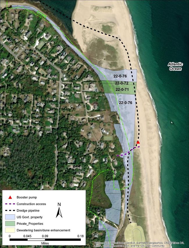
8. Sediment sidecast is an improvement over removal from the system, but by placing it 60-80 ft
       from dredged area, it will be readily available for redeposition by strong currents.

Response: Sidecast dredging is commonly used in other areas of the country and is the preferred
method of dredging in shallow inlets and waterways where high current velocities and shallow waters
make use of a conventional hydraulic pipeline dredge difficult to operate1. Connections to discharge
pipelines with a conventional hydraulic pipeline dredge can be difficult in areas with high current
velocities. The sidecast dredge method does cast the material back into the waterway rather than
remove it, but flow concentration in the deeper dredged part of the channel will help to maintain the
channel. The potential for sediment to be transported back into the channel is higher with the sidecast
dredge method than it is with a conventional hydraulic pipeline dredge. However, given the absence of
viable beneficial reuse sites within reach of a hydraulic pipeline dredge operating behind the barrier
beach, the sidecast dredge offers a viable alternative for creating a navigable channel.

    9. Sidecast dredging is not appropriate since it doesn’t remove material from the dynamic area and
       is able to migrate back into the channel

Response: See answer to #8.

    10. Method of sidecast dredging was briefly discussed and then discarded during earlier discussions

Response: The project team discussed the possibility of sidecast dredging with the Select Boards and
the Nauset Estuary Stakeholders Group. Sidecast dredging was identified as a preferred method of
dredging for areas behind the barrier beach if it can be approved and permitted by the regulatory
agencies.

    11. Sidecast dredging should not impact access to Cable Creek

Response: The project team agrees that sidecast dredging should impact access to Cable Creek. The
sidecast dredge has the ability to rotate the discharge boom so that dredged material can be directed at
different angles to the dredge. In the area where Cable Creek meets the main channel behind the
barrier beach, the discharge booms will direct material to the shoals on either side of Cable Creek to
avoid impacts to navigation to/from the Creek. The engineering plans will be revised to reflect a zone of
no sidecast discharge in the Cable Creek channel.

1
 US Army corps of Engineers, 2015. Dredging and Dredged Material Management. Engineering Manual EM 1110-
2-5025.
Shellfish Relay

    12. Shellfish relays are proposed as a form of mitigation for project impacts to shellfish resources.
        Has a plan for the shellfish relays been developed yet?

Response: A shellfish relay plan was not included in the Draft EENF. In response to this comment, the
project team has worked with staff from Orleans and Eastham Natural Resources Departments to
develop a Shellfish Relay Plan. A copy of the Plan is provided in Appendix C.

    13. It will be important to evaluate whether the shellfish relays are sufficient in mitigating impacts
        to shellfish resources.

Response: Staff from the Natural Resources Departments of both towns will be closely involved with
the shellfish relay program. They will maintain records for the relay program including shellfish species
and densities prior to dredging, number and type of shellfish relayed, and quantities and species
harvested from the relay areas. Regular reports on the shellfish relay program will be reviewed by Town
staff, Massachusetts Division of Marine Fisheries, and NOAA National Marine Fisheries to evaluate
success of the relay and to adaptively manage the program to ensure a productive mitigation program.
Other possibilities for mitigation, such as a contribution towards a shellfish reseeding program or
changes to the dredge program, can be adopted through adaptive management if the relays are not
sufficient in mitigating impacts to shellfish.

    14. How much will the shellfish relays cost?

Response: Costs for the shellfish relays have not been developed yet. Cost estimates will be developed
and provided the Towns separately from the MEPA EENF process.

Resource Area Alterations/Impacts

    15. The EENF lists permanent alterations to the resources. Is mitigation for these impacts
        proposed?

Response: Mitigation is proposed in the form of a shellfish relay and dune enhancement in the area
north of Nauset Public Beach. Time of year restrictions for all in-water and beach work will be followed
to avoid impacts to estimated and priority habitat, finfish, and shellfish resources. These measures will
serve to avoid and/or minimize impacts to land containing shellfish, estimated habitats of rare wildlife,
coastal dunes, and land under the ocean. Additional mitigation is not proposed at this time.

    16. Dredging a 100-ft channel behind barrier beach will impact the stability of the barrier beach.

Response: See response to questions 3 and 4 above.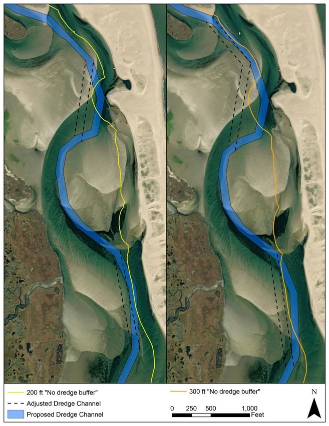
17. The Draft EENF states that dredging within the estuary is not expected to result in changes in
        marine productivity, but the evidence for this statement has not been documented.

Response: The Massachusetts Wetlands Regulations 310 CMR 10.25(3)(d) require that improvement
dredging for navigational purposes affecting land under the ocean shall be designed and carried out
using the best available measures so as to minimize adverse effects on marine fisheries and wildlife
habitat caused by changes in marine productivity that result from the suspension or transport of
pollutants, the smothering of bottom organisms, the accumulation of pollutants by organisms, or the
destruction of marine fisheries habitat or wildlife habitat. As stated in the Draft EENF, changes in marine
productivity as a result of these actions are not expected. Supporting evidence includes the following:

    •    Extensive sediment chemistry testing for volatile organics (VOCs), polycyclic aromatic
         hydrocarbons (PAHs), polychlorinated biphenyls (PCBs), extractable petroleum hydrocarbons
         (EPHs), and metals that showed non detect/below threshold levels of these pollutants in the
         Nauset Estuary sediments proposed for dredging. As such, changes in marine productivity will
         not be caused by the suspension or transport of pollutants or by the accumulation of pollutants
         by organisms.
    •    Changes in marine productivity caused by smothering of bottom organisms could occur by
         settling of sediments resuspended during the dredging operation or by direct placement of
         dredged material on the seafloor. Studies of sediment resuspension during dredging show that
         the vast majority of resuspended sediments resettle close to the dredge within 1-hour, and only
         a small fraction takes longer to settle.2 3 4 Field studies have also shown that sediments
         typically settle within 50 meters from the point of dredging. 5 While variables like sediment size
         and current velocities can impact settling rates and locations, most studies have shown little
         impact to water quality, benthic organisms, and marine productivity from dredging operations.
         At Nauset Estuary the coarser-grained sandy material is expected to settle out of suspension in
         the immediate vicinity of the dredge. The finer-grained sediments in the Priscilla and Mill Pond
         channels will be dredged using a hydraulic pipeline dredge, which causes less sediment
         resuspension than mechanical dredges. Sediment resuspension from mechanical dredging in
         the Town Cove and Eastern Main channels could be managed through the use of an
         environmental bucket and/or by setting limits on the vertical bucket speeds. Therefore,
         changes in marine productivity caused by settling of resuspended sediments is not expected to
         be an issue, and can be further managed through construction protocols, if desired. Sidecast
         dredging in the channel behind the barrier beach will cast 0.5 to 2 ft of sandy material across
         the seafloor. Benthic organisms in the area are well suited to living in a dynamic environment

2
  Wright, T.D., 1978. Aquatic Dredged Material Disposal Impacts. Synthesis of Research Results, Dredged material
Research Program, Technical Report DS-78-1, U.S. Army Engineer Waterways Experiment Station Environmental
Laboratory, Vicksburg, MS.
3
  Van Oostrum,R.W., Vroege, P., 1994. Turbidity and Contaminant Release During Dredging of Contaminated
Sediments. Proc. Of the Second International Conference on Dredging and Dredge Material Placement, Dredging,
’94.
4
  Grimwood, C., 1983. Effects of Dredging on Adjacent Water. ADCE Journal of Environmental Engineering
109(1):47-65.
5
  MEC Analytical Systems, Inc., 2002. USACE Pilot Capping Project – Phase 1 Water Quality Monitoring Data – Final
Report. Prepared for the US Army Corps of Engineers and the Southern California Coastal Water Research Project
Authority, Los Angeles,CA.
with shifting sediment and are expected to recolonize rapidly. As such, changes to marine
        productivity caused by smothering of bottom organisms is not expected with the proposed
        project.
    •   Finally, the dredging will be required to adhere to time of year restrictions for in-water work
        that are designed specifically to avoid and/or minimize impacts to marine productivity.

    18. Will changes to channel hydrodynamics impact shellfish habitat and water quality

Response: Numerical modeling conducted during the initial 2016 feasibility study indicated that the
dredging will result in a small increase in tide range, but the project is not expected to result in
measurable changes in water quality or current velocities that could impact shellfish habitat.

    19. Impacts of settling of silts and clays on shellfish beds must be considered

Response: See response to question #17 above.

Restoration of Disturbed Dune Areas

    20. What dune areas are anticipated to be disturbed?

Response: Coastal dunes in the area of the dewatering basin north of Nauset Public Beach will be
disturbed during dredging of the Priscilla and Mill Pond channels (see Draft EENF Figure E-8). Once the
dredging is complete and the sediments have dewatered, grades across the dewatering basin will be
restored to their pre-existing conditions and a secondary dune will be established for added resiliency.

    21. Have you calculated the areas of dune disturbance?

Response: Construction of the dewatering basin will impact 7 acres of coastal dune. All 7 acres will be
restored upon completion of the project by covering the dredged material with a 1-3 ft thick layer of
native dune sediment, constructing a secondary dune with a higher elevation that what currently exists,
and replanting with Cape American beach grass. Areas of coastal dune between the dewatering basin
and the seaward end of Callanan’s Pass will be temporarily disturbed during placement and pick up of
the dredge pipeline. This work will result in temporary impacts to 0.5 acres of coastal dune. All
disturbed areas will be regraded to original elevations and any areas of disturbed vegetation will be
replanted with Cape American beach grass.

    22. Who will be responsible for regrading and replanting these areas?

Response: It will be the responsibility of the Towns selected contractor to ensure that all coastal dune
areas are restored, regraded, and planted according to the plans and specifications for the project.
Post Construction Monitoring & Maintenance Plan
23. Has a Post Constructing Monitoring and Maintenance Plan been developed yet?
Response: Yes, Section J of the EENF contains the Post Construction Monitoring and Maintenance Plan.
Permission of Private Property Owners
24. The dredge pipeline between the Priscilla and Mill Pond channels and the dewatering basin
north of Nauset Public Beach will primarily be on property owned by the Town of Orleans.
Exceptions to this occur at the north end of Nauset Heights where the pipeline is proposed to
cross property owned by the US Government (Cape Cod National Seashore), and two (2) private
properties. Have these property owners been notified and has permission been granted for the
use of their property?
Response: Staff from the Cape Cod National Seashore (CCNS) are on the Nauset Estuary Stakeholder
Group and updates have been provided to the CCNS since the beginning of the project. As a result, the
CCNS was informed that the pipeline would cross land owned by the US Government (Figure 3). It is
expected that questions surrounding use of US Government property for this use will be reviewed
during the National Environmental Policy Act (NEPA) review and permitting process.
The project team has contacted the two (2) private property owners to describe the project and the
need to temporarily lay the dredge pipeline on their beaches. Impacts to these beaches will be for
approximately 9 weeks during the winter when the Priscilla and Mill Pond channels are being dredged.
The project team will continue to coordinate with these private property owners to address their
concerns and to request permission to use their beaches.Figure 3. Dredge pipeline route between the Priscilla channel and the dewatering basin north of
Nauset Public Beach. The dredge pipeline crosses property owned by the Town of Orleans
(unshaded), US Government (shaded blue), and two private property owners (shaded
green).Construction Related Activities/Impacts
25. The dredge, support boats, and booster pumps needed for the dredging, and the excavator and
front-end loaders required for the dewatering basin will require regular refueling during the
period of construction. Where will fuel for this equipment be stored?
Response: A fuel service company will be contracted to provide regular fuel deliveries to the site for the
duration of the project. This will occur much the same as fuel trucks delivering home heating oil.
• For the Town Cove and Western Main Channel dredging work all fuel deliveries will be made
from a fuel truck to the primary support boat via the Goose Hummock Town Landing. The fuel
will be pumped into a diesel transfer tank located on the primary support boat. The support
boat will then pump the fuel into the reserve tanks on the dredge. It is estimated that refueling
for the mechanical dredging will be required every other day for the duration of the project.
• For sidecast dredging in the Channel Behind the Barrier Beach and the Eastern Main Channel all
fuel deliveries will be made from a fuel truck directly to the dredge superstructure via the
Priscilla Rd. Town Landing. The support boats will also be refueled from the Priscilla Rd. Town
Landing. It is estimated that refueling form the sidecast dredging equipment will be required on
a weekly basis.
• For hydraulic pipeline dredging of the Priscilla and Mill Pond channels fuel deliveries will be
made from a fuel truck directly to the dredge superstructure via the Priscilla Rd. Town Landing.
It is expected that refueling of the dredge will be required on a weekly basis. Daily fuel
deliveries will be made from the Priscilla Rd. Town Landing for the support boats and the first
in-line booster pump, and from Callanan’s Pass for the second booster pump.
• For the equipment needed for construction and operation of the dewatering basin, all fuel
deliveries will be made from the north end of the Nauset Public Beach parking lot.
26. Does the Barnstable County Dredge have equipment that can be used in the estuary? Has it
been proven that the equipment can operate in the estuary?
Response: The Barnstable County Dredge (BCD) has two dredge superstructures. The smaller Cod Fish II
is an Ellicott 670 and the larger Sand Shifter is an Ellicott 870. The BCD also has one (1) booster pump
and a variety of support boats. The project team has been in contact with the BCD regarding work in
Nauset Estuary. Use of the Cod Fish II or Sand Shifter has not been completely decided at this point.
Maximum current velocities in the channel behind the barrier beach are near the upper limit of safe
operations with the Cod Fish II without modifications. If used in this part of the estuary, dredging would
likely be shut down during periods of maximum current velocity. The Sand Shifter is capable of
operating in higher current velocities than the Cod Fish II and has a greater pumping distance. In either
case, a second booster pump would need to be rented to reach the dewatering basin north of Nauset
Public Beach from the channel behind the barrier beach or the Priscilla and Mill Pond channels. The BCD
does not have a sidecast dredge but they have indicated interest in procuring one as a number of
inlets/harbor on the Cape could easily be maintained using this method of dredging. A sidecast dredge
is the optimum type of dredge equipment to use for the channel behind the barrier beach because of
the shallow water depths, higher current velocities, and extensive pumping distances required with theconventional hydraulic pipeline dredge. The Ellicott hydraulic pipeline dredges can be retrofitted into a
sidecast dredge.
27. The safety of dredge operations in Nauset Estuary where there are high current velocities is a
concern.
Response: Because of the challenging operating conditions in Nauset Estuary, primarily in the channel
behind the barrier beach, it will be important to utilize an experienced dredge crew. The Town of
Orleans Dredge Purchase Feasibility Study recommended that the BCD with their experienced crew be
contracted for initial dredging behind the barrier beach to evaluate performance of the dredge
equipment in dynamic areas of the estuary.
28. How will the hydraulic/sidecast dredge get into the estuary? Will they have to come in on the
highest spring tide of the year and stay in the estuary for 1 entire year?
Response: It is expected that the hydraulic and sidecast dredge superstructures will be brought into the
estuary through the inlet, traveling north through the ocean from Chatham Harbor. Passage through
the inlet will be restricted to high tide and possibly even a monthly spring high tide. Once the project is
complete the dredge equipment will leave through the inlet on a high tide and will not be trapped in the
estuary for an entire year.
29. If the dredge has to be brought by truck and launched at Goose Hummock, has the cost for this
been factored into the cost estimate?
Response: If depths in the mouth of Nauset Estuary are deemed insufficient to allow the
hydraulic/sidecast dredge equipment to enter the estuary through the inlet, the dredge will be
disassembled, brough over-the-road, assembled on-site, and launched at Goose Hummock
and/or Cove Road landing(s). Costs associated with this method of dredge delivery would be
determined by the contractor at the time the project is put out to bid.
30. Will the booster pumps required for the Priscilla and Mill Pond channel dredging be noisy? Can
the sound be muffled in any way?
Response: Two (2) booster pumps will be required for the Priscilla and Mill Pond channel
dredging. The first in-line booster will be on a barge located near the east end of the Priscilla
channel, and the second in-line booster will be located on the beach near the base of Callanan’s
Pass on Town of Orleans property (see Draft EENF Figure C-7). Working hours for the booster pumps
will generally be limited from 7 AM to 3 PM during the period of dredging, which will occur for an
approximate 3-week period between mid-October and mid-January. To minimize noise disturbance
from the booster pumps, which can be loud, the construction contractor can be required to use
residential grade silencers (i.e., mufflers). The silencers would reduce the decibel levels to legal levels.31. Dredging in the channel behind the barrier beach is estimated to take approximately 50 days.
With weather and equipment repair delays it could be considerably longer. Will the time of year
restrictions for dredging allow for more than 50 days of work?
Response: Time of year restrictions for all in-water work are expected to allow dredging between mid-
October and mid-January. This allows for an additional 40 days of dredging above the estimated 50
days.
32. How many trucks per day will be required to remove dredged sediment from the Goose
Hummock Town Landing?
Response: It is estimated that mechanical dredging of the Town Cove and Western Main Channel
reaches will take approximately 61 days to complete. Assuming tri-axle roll-off containers with 16
cubic yard capacity are used, it will take approximately 10 truckloads each day to remove the
dredged sediment from Goose Hummock. This number could be reduced to 6-7 truckloads
each day, if larger, trailer-sized (26 cubic yard) containers are used.
33. Trucking dredged sediment away from the Goose Hummock area will cause an interruption to
the mixed residential/commercial area. A traffic study should be performed to evaluate impacts
to the area and to assess the maneuverability of trucks entering/exiting the site.
Response: Trucking the dredged sediment away from the Goose Hummock Town Landing will occur
over the estimated 61 days of dredging during the period mid-October to mid-January. Businesses in
the area are either closed during this period or experiencing a reduction in activity. Owners of the
Orleans Inn and Goose Hummock Marine Shop have been apprised of the proposed activity and are in
support of the project. The trucking routes to/from the site will not enter any residential areas;
however, the Towns could post notices about increased truck traffic associated with the project so that
residents can adjust accordingly.
The road layout around the Goose Hummock area does not present any unusual circumstances that
would make the trucking operations difficult. In fact, the site and nearby road layout provides an ideal
location for trucking. Access to and from the site will likely be from Rt. 6A through the intersection in
front of the Orleans Waterfront Inn. It is possible that trucks could also use the road by the Knack to exit
the site. The left-hand turn from the intersection is greater than 90 degrees, but there is plenty of room
to make the turn onto Old Country Rd if the trucks can use the extra space provided by the parking area
at the Inn. The trucks could also pull straight into the Windmill parking area and then back down Old
Country Rd. to the Town Landing. The project team does not feel that a traffic study is necessary.
34. Can traffic along Callanan’s Pass be minimized?
Response: The Draft EENF indicates that Callanan’s Pass may be used as an access point for delivery of
the dredge pipeline to the beach and dune areas. To minimize this traffic impact on local residents,
alternate routes for delivery of the pipeline have been evaluated and found to be preferable. Theseinclude an access route at the south end of Nauset Public Beach where the pipeline could be
transported through the existing beach access path and then north along the beach. Alternatively, the
pipeline could be floated into the estuary through the inlet and transported to the beach through the
overwash/barrier beach at the eastern end of the Priscilla channel. Since both of these alternatives are
preferrable from a logistics standpoint, the access route for the pipeline along Callanan’s Pass will no
longer be pursued.
Delivery of the second in-line booster pump will be via Callanan’s Pass. The work will require one day
for delivery and one day for retrieval, with all work taking place between mid-October and mid-January.
Fuel deliveries to the booster pump will also take place via Callanan’s Pass. It is expected that the
booster pump will be fueled once daily from a delivery truck, similar to the trucks that deliver home
heating oil.
35. How will work at the dewatering area north of Nauset Public Beach impact the existing
footpaths from Nauset Heights to beach?
Response: There are currently two footpaths through the dunes from the southern end of Nauset
Heights to the beach. One connects Surf Path to the beach and the other connects areas north of Inlet
and Cliff Roads to the beach. A third path runs along the landward/back side of the dune between the
north end of Inlet Road and Callanan’s Pass. Figure 4 shows the location of the proposed dewatering
basin and dredge pipeline in relation to these paths. The location of the dewatering basin will require
that the southern footpath between Surf Path and the beach be closed during construction. Access to
the beach via the northern footpath will not be interrupted. Similarly, foot traffic along the third path
on the back side of the dune will also remain open during construction. The dredge pipeline is proposed
to run along the existing footpath south of Callanan’s Pass; however, the pipeline can easily be stepped
over and should not present an impediment to beach goers.
Closure of the Surf Path access path and all construction in the dewatering area is expected to last
approximately 9-12 weeks during the period between mid-October and mid-January. Once construction
is complete and the area is restored, the access along the footpath will be restored.Figure 4. Proposed dewatering basin and dune enhancement area north of Nauset Public Beach.
36. Will the dewatering area be used multiple times? What areas would be used for dewatering if
        future maintenance dredging of the Priscilla and Mill Pond spur channels is required?

Response: The dewatering area north of Nauset Public Beach is planned for use once during dredging of
the Priscilla and Mill Pond channels. Once the dredging is complete and the sediments have dewatered,
the primary dune will be restored, and a secondary dune will be constructed along the western edge of
the dune. The secondary dune enhancement will help to build resiliency to the impacts of sea level rise
and climate change. Alternate plans will be required for dredged materials dewatering if future
maintenance dredging of the Priscilla and Mill Pond spur channels is required. Depending on conditions
of Nauset Public Beach at the time of the maintenance dredging, it may be possible to dewater the
material at the public beach and beneficially reuse it for added resiliency on site.

    37. How long will it take to build and restore the dewatering area?

Response: Work at the dewatering basin is expected to take approximately 9-12 weeks. Construction of
the dewatering basin is estimated to take 3-4 weeks and the actual dredging is estimated to take 1.5-3
weeks. Restoration of the dune and construction of the secondary dune after the dredging is complete
should take an additional 3-4 weeks.

    38. Does the proposed project require management of material at the dewatering basin?

Response: During the dredging phase of the project there will be heavy equipment (i.e., excavator, front
end loader) managing sediment in the dewatering basin. While it is expected that the material will
dewater quickly due to the percentages of sand in the dredged slurry, it may be necessary to move
and/or regrade material within the basin to facilitate the dewatering process.

    39. The Draft EENF did not address the transportation section of the application, but there will be a
        significant number of trucks taking material away from Goose Hummock.

Response: The proposed project does not trigger any of the Transportation thresholds for filing an ENF
or EIR. Consequently, the Transportation section of the ENF application is not required.

Use of Center for Coastal Studies Data

    40. The Town of Eastham has contracted with the Center for Coastal Studies (CCS) to complete
        studies focused on mapping the future and current form/location of the barrier beach, and
        evaluation of finfish and macroinvertebrates in the estuary. These studies are due to be
        completed in late spring 2022. Where do these studies fall into the permitting process?

Response: The project team only recently became aware of the studies that the CCS has been
contracted to complete. Assuming the EENF is filed at the end of July, the Secretary’s Certificate with a
Scope for the EIR will be issued on September 10, 2021. It would be extremely helpful to have the CCS
study findings to include in the EIR; however, it is expected that the EIR will be complete and ready to
submit prior to the spring of 2022. The Towns should consider whether they want to delay submitting
the EIR to allow the CCS study findings to be included.
Project Need
41. Improvements to public safety should not be considered as a reason to dredge the estuary.
Response: Improvements to public safety have always been one of the goals of the project. As
indicated in the response to question #3, emergency first responders and members of the Fire Dept in
Eastham and Orleans expressed the need for a safe and navigable channel to ensure that emergency
first responders can reach commercial and recreational boaters in distress, regardless of tide, day or
night.
42. The need to dredge the estuary in order to support local economies, tourism and natural beauty
of area is flawed, since the project will bring more boats to an already busy area and there will
be dredge equipment in estuary for much of each year.
Response: The primary goals of the project, to improve navigation and public safety for commercial
and recreational users of Nauset Estuary, have been clearly stated in the EENF. Ancillary benefits of the
project are that it will support sectors of the local economy that are focused on the marine
environment, including a portion of the economy driven by tourism. There is no reasonable indication
that the natural beauty of Nauset Estuary will be adversely impacted by the proposed project, nor is
there evidence that the project will result in a significant increase in commercial or recreational boaters.
Dredge equipment will be in the Town Cove, Western Main Channel, Priscilla, and Mill Pond Channels
for up to 3 months every 8 to 15 years, and in the Channel behind the Barrier Beach for up to 3 months
potentially every year. The presence of dredge equipment will result in a temporary impact to the
natural beauty of the estuary.
Consistency with Local and Regional Planning Documents
43. The assumptions in the Draft EENF regarding Eastham’s Strategic Plan (ESP) with regard to
improvements to modes of transportation are inaccurate.
Response: When assessing consistency with local and regional plans, the EENF interpreted the proposed
project as being consistent with the ESP, which includes “strategies to improve safety for all modes of
transportation”. Although the ESP does not state that vessel navigation is excluded as a mode of
transportation, Town Officials have clarified that this strategy should only apply towards creating
“complete streets”. As such, the Local and Regional Consistency text of the EENF will be altered to
clarify this point. In addition, Town Officials have also noted the ESP “does not view dredging as
improving safe travel for all users for all modes of transportation” or as “providing all members of the
public access to recreation”. These points will be clarified in the EENF.44. The no dredge alternative also meets the open space objectives of the local plans (to maintain
semi-rural character of Town for recreation and to work towards harmony between the natural
environment and local culture, as well as protecting coastal and estuary environments).
Response: Agreed, the no dredge alternative does meet the open space objectives of the local plans.
However, Section III.B. of the Draft EENF application specifically asks whether the proposed project is
consistent with the open space objectives of the local plans. The preferred dredging alternative has
been designed to be as consistent as possible with open space objectives, while also achieving the
project goals. If all coastal projects were designed only based on open space objectives, there would be
no opportunity to consider economic or development interests benefiting coastal residents and
businesses.
45. The statement that the proposed project will result in substantial public benefit to the
economies of Eastham and Orleans is grossly overstated.
Response: The proposed project will benefit business owners located on the estuary and others in the
Towns that provide marine related services. To the extent that these businesses support tourism in the
area and employ local residents, the project will also benefit these sectors of the local economy. The
EENF will be revised to recognize that the proposed dredging project will benefit these select sectors of
the local economy.
46. Benefits of the project on economic activity and employment centers is over-stated. There will
be no impact to cultural resources or low-density, sprawling development, but there will be
negative impacts to natural resources from increased boat traffic.
Response: Recognizing that the proposed dredging project will benefit select sectors of the local
economy that focus on commercial and recreational uses of the estuary, the benefits of the proposed
project for the local economies and employment centers will be modified in the EENF.
The proposed project does not aim to increase boat traffic, nor is there a reasonable indication that the
proposed project will result in a significant increase of commercial or recreational boaters. Rather, the
project is intended to benefit existing resource users and boaters. Those who are already familiar with
the area, either as a commerce center or as natural environment, are likely to continue use of the area
while those who do not utilize the estuary system currently are unlikely to become aware of or seek out
the estuary as a result of the proposed project. In addition, a variety of mitigation measures (Section I
of the Draft EENF), as well as a Monitoring and Maintenance Plan (Section J of the Draft EENF), have
been developed to minimize project impacts on natural resources.
47. Dredging will negatively impact open space areas on the land which will have to watch dredge
equipment in the estuary for much of each year.
Response: Although dredging equipment may be present in the channel behind the barrier beach for up
to 3 months each year, the inconvenience of a temporary disruption in view during the winter seasonshould be considered minimal in comparison to the open space benefits of the proposed dredging
project, which include increased navigability for recreational users to experience additional viewpoints
and open spaces not accessible by land. Due to the varied nature of recreational uses of the estuary,
the dredge equipment during fall and winter seasons will only be visible for a relatively low portion of
time during resource users’ interactions with the beach and estuary. The presence of dredge equipment
on the beach, and the effect on open space views, will be added to the Local and Regional Consistency
section within the EENF.
48. Statement that the project is consistent with the Eastham Harbor & Waterways Management
Plan (TEHWMP) is wrong since that plan refers to Rock Harbor and cannot be extrapolated to
Nauset Estuary.
Response: The TEHWMP only specifically mentions Nauset Estuary dredging when mentioning
“discussions with Orleans about dredging in Nauset Harbor are ongoing”. Town Officials have clarified
that dredging goals listed in the plan refer only to Rock Harbor. Language referencing the TEHWMP in
the EENF will be revised to clarify that the Dredging Management Plan outlined in the TEHWMP has a
“focus on Rock Harbor” and that the priorities outlined therein are not in reference to the proposed
Nauset Estuary dredging project, since a plan regarding management of Nauset Estuary has not been
formally prepared by the Town of Eastham.
49. There are significant land uses adjacent to the project that have not been considered. These
include the estuary environment, Land Under the Ocean, and properties on the western
boundary of the estuary that become more vulnerable to storm waves if the project adversely
impacts the protective barrier beach.
Response: Information on the estuary environment and on Land Under the Ocean (LUO) including
condition of the existing environment (EENF Section D), project impacts (EENF Section F), and proposed
mitigation actions (EENF Section I) are discussed in detail throughout the Draft EENF. Additional
information related to the natural environment of the estuary, specifically LUO, will be added to the
Compatibility with Adjacent Land Uses section of the Local and Regional Consistency document within
the EENF. For additional information related to anticipated impacts of the project on the stability of the
barrier beach see responses to comments #3 and #4 above.
50. Is the driver for the project the 9 impacted commercial vessels that moor near the entrance to
Nauset Estuary?
Response: Section C 1.0 of the Draft EENF provides a detailed description of the commercial and
recreational users of the estuary. The project will benefit users of the thirteen (13) town landings,
twenty (20) mooring areas, numerous private property owners with marine craft, and businesses at
Goose Hummock Marina and Nauset Marine. Benefits of the project extend well beyond the
commercial vessels that moor their boats near the entrance to the estuary.51. Lack of safety incidents in estuary/behind barrier beach means public safety is not a reason to
dredge.
Response: As indicated in the response to question #3, emergency first responders and members of the
Fire Dept in Eastham and Orleans expressed the need for a safe and navigable channel to ensure that
emergency first responders can reach commercial and recreational boaters in distress, regardless of
tide, day or night. Records of emergency response incidents from both towns since 2016 show between
4 and 11 incidents per year in the estuary (Appendix A).
52. Data on finfish and lobster landing declines since 2013 provided in the Draft EENF do not
definitively indicate that shoaling in the estuary is cause of the decline.
Response: In addition to showing a decline in finfish and lobster landings in the estuary since 2013, the
Draft EENF also indicates that the number of permits issued for lobster and finfishing in Nauset Estuary
began to decline around 2012 because of the difficulties associated with navigating between the inlet
and the town landings and moorings. The EENF acknowledges a likely link between the decline in
landings and the reduced number of permits issued. The EENF will be revised to reference other
possible causes for the decline in finfish and lobster landings, such as natural fluctuations in populations.
However, the data on finfish and lobster permits issued clearly shows a decline since 2012 and
interviews with local fishermen indicate that shoaling and difficulties with navigation in the estuary are
the reason.
53. Does a greater number of boats from the proposed project drive the need for a 100-ft wide
channel, or does the wider channel create a safety problem by bringing too many boats?
Response: The proposed project does not aim to increase boat traffic, nor is there a reasonable
indication that the proposed project will result in a significant increase in the number of commercial or
recreational boaters. The 100-ft wide channel was identified as the preferred alternative for the
channel behind the barrier beach based on a number of logistical and environmental criteria (see
Appendix B). Bringing a greater number of boats to the estuary was not one of the criteria; however,
benefits to boater safety from a wider channel in an area where strong tidal currents and conflicts
between commercial and recreational boaters often present safety hazards was considered.
54. The Draft EENF Section H addresses compliance of the proposed project with Mass Department
of Environmental Protection (DEP) regulations 310 CMR 9.06 and 9.07 for discharge of dredged
material and improvement dredging in Outstanding Resource Waters (ORWs). This section of
the Draft EENF indicates that the project will facilitate enlargement of public landings and
mooring fields and makes it clear that the Town of Orleans wants to increase boat traffic in the
estuary. The impacts of increased boat traffic must be evaluated.
Response: The Draft EENF indicates that the project “is being proposed to restore safe and navigable
waterways to areas that were previously navigable prior to shoaling”, and that the work “will facilitate
the enlargement of facilities such as public landings and mooring fields”. It further states that the“proposed work is needed to facilitate the enlargement of facilities such as public landings and mooring
fields that have been identified as priority actions in both towns”. The proposed project clearly complies
with the regulations in 310 CMR 9.06and 9.07 for work in an ORW in that it will facilitate the
maintenance, repair, replacement, and reconstruction of structures or facilities for water-dependent
uses (i.e., public landings and mooring fields). The Draft EENF indicated that the project would also
facilitate the enlargement of these facilities; however, there is no indication at this time that either
Town has plans to enlarge the public landings and mooring fields that serve Nauset Estuary. The EENF
will be revised to clarify this point.
Maintenance of existing infrastructure and support for commercial and recreational uses of Nauset
Estuary are consistent with planning efforts by both Towns. Strategic objectives #1 and #2 in the
Eastham Harbor and Waterways Management Plan published in February 2020 include:
• Strategic Objective #1: Maintain and improve the town’s existing infrastructure, access points,
and natural resources.
• Strategic Objective #2: Create new opportunities to promote and support commercial and
recreational uses of the harbor, shoreline, and waterways.
The proposed project will help the Town of Eastham meet these objectives.
55. The Draft EENF should emphasize that a large portion of the commercial fleet has relocated to
moorings near the inlet and that refueling of the vessels in this area is placing the estuary at risk
for a fuel spill.
Response: The EENF will be updated to reflect these points.
Costs
56. A number of questions were asked about costs associated with the project, and whether costs
for construction monitoring, bidding assistance, pre- and post-construction monitoring and
surveys have been factored into the cost estimates.
Response: The MEPA EENF review process does not specifically request information on project cost.
Updated cost estimates for the project that include all aspects of the work will be prepared and
provided to the Towns.
General Comments
57. Who owns land under the ocean?
Response: The Commonwealth of Massachusetts owns land under the ocean in Nauset Estuary.58. The Draft EENF includes a section on historical permits issued for dredging in the estuary.
Despite this information the proposed project must be considered improvement dredging.
Response: Section D 1.12 of the Draft EENF provides information on past permits issued for dredging in
the estuary. These permits were issued between 1924 and 1974 for dredging and filling in relation to
small and site-specific projects. The information was intended to summarize the history of dredging in
the estuary, rather than to make a case that the proposed project should be considered maintenance
dredging. The Draft EENF clearly states that the proposed project is considered improvement dredging.
59. Section K of the Draft EENF indicates that the project will be funded by a State (Office of Coastal
Zone Management) funded grant. Is the CZM grant going to cover the entire cost of the
dredging?
Response: Reference to funding for the project via a State CZM grant was made in error. While it is
entirely possible that other sources of State funding may be sought for project construction, it is not
likely that the project would be eligible for a grant from CZM.
60. Can the aerial photos in the Draft EENF (i.e., Figures B-2 and C-6) be changed to something more
recent?
Response: The aerial photos used for the figures in Draft EENF Sections B and C are the most recent
aerial orthoimagery available from the state MassGIS Bureau of Geographic Information. These aerial
photos were collected in the spring of 2019.
61. When will the Cape Cod National Seashore provide formal input on the proposed project?
Response: Staff from the CCNS have provided input and comments on the project through their
participation with the Nauset Estuary Stakeholders Group. It is expected that the CCNS will submit a
formal comment letter during the MEPA comment period on the EENF.
62. Can the EENF be updated to indicate the planned studies in Mill Pond (i.e, sediment coring)?
Response: Additional field investigation in the Mill Pond channel are planned for the summer 2021.
These include sediment coring and laboratory testing, red tide cyst counts, eelgrass mapping, and
shellfish resource investigations. The EENF will be updated to reflect that the results of these
investigations are pending, and will be added to the EIR when it is published.You can also read