Synchronous Pumice Mantle Found on Santorini Volcano
←
→
Page content transcription
If your browser does not render page correctly, please read the page content below
International Journal of Geosciences, 2021, 12, 329-346
                                                                                                   https://www.scirp.org/journal/ijg
                                                                                                            ISSN Online: 2156-8367
                                                                                                              ISSN Print: 2156-8359

Synchronous Pumice Mantle Found on
Santorini Volcano

Walter L. Friedrich1*, J. Richard Wilson1, Annette Højen Sørensen1, Samson Katsipis2

Department of Geoscience, Aarhus University, Aarhus, Denmark
1

Museum of Minerals and Fossils, Perissa, Greece
2

How to cite this paper: Friedrich, W.L.,        Abstract
Wilson, J.R., Sørensen, A.H. and Katsipis,
S. (2021) Synchronous Pumice Mantle Found       It is generally accepted that the vent of the 3.6 ka Minoan eruption was si-
on Santorini Volcano. International Journal     tuated in the water-filled Santorini caldera prior to the Minoan eruption. One
of Geosciences, 12, 329-346.                    should therefore expect to find huge quantities of pumice and ash on the in-
https://doi.org/10.4236/ijg.2021.124018
                                                ner side of the caldera walls, but there is only a relatively small amount pre-
Received: February 26, 2021                     served. An unexpected discovery of remnants of a synchronous pumice man-
Accepted: April 12, 2021                        tle of the Minoan eruption appears to solve this enigma. A lengthy period of
Published: April 15, 2021
                                                erosion and the intensive quarrying of pumice for the construction of the
Copyright © 2021 by author(s) and               Suez Canal (1859 to 1869) led to the removal of an enormous amount of ma-
Scientific Research Publishing Inc.             terial and information for generations of geologists. The synchronous pumice
This work is licensed under the Creative        mantle covered the whole caldera wall from rim to sea level. Archaeological
Commons Attribution International
                                                finds under the pumice mantle show that the caldera wall was accessible and
License (CC BY 4.0).
http://creativecommons.org/licenses/by/4.0/
                                                inhabited in the Bronze Age. Furthermore, this discovery documents that
                Open Access                     only one Minoan eruption took place and that the so-called “Lower pumice”
                                                does not exist on Santorini.

                                                Keywords
                                                Minoan Eruption, Tephrochronology, Visual Geology, Geoarchaeology

                                              1. Introduction
                                              The 3.6 ka Minoan eruption was one of the strongest experienced by human-
                                              kind. On Santorini it buried a flourishing culture under a thick mantle of pumice
                                              and ash, thus creating a “prehistoric Pompeii” as it was called by Fouqué [1].
                                              Three main phases of the eruption can be recognised in the deposits as described
                                              by Friedrich [2] (Figure 1). Prehistoric ruins on the island of Therasia and a
                                              prehistoric house on Thera were excavated by French scholars. After a period of
                                              about 120 years with no activity, excavations were started at Akrotiri in 1967 by

DOI: 10.4236/ijg.2021.124018 Apr. 15, 2021                        329                          International Journal of Geosciences
W. L. Friedrich et al.

                               Figure 1. The photo shows the three main phases of the Minoan eruption in Fira quarry
                               (ca. 200 m asl). The eruption column of the first phase (yellow arrow) reached a height of
                               several kilometres and gave rise to air fall deposits of pumice. The entry of sea water into
                               the magma chamber triggered ring-shaped explosions that produced base surge deposits
                               during the second phase (green arrow). The crater widened in the third eruption phase
                               and created pyroclastic flow (red arrow). Material on the walls of the chamber was also
                               ejected and created bomb sacs (above the persons) in the unconsolidated deposits (Photo
                               Friedrich).

                               Marinatos [3]. Here a Bronze Age town with houses with up to three stories has
                               been excavated [4]. The houses were decorated with colourful wall paintings [5]
                               and contained decorated pottery and other artwork. A detailed description of the
                               Minoan eruption and its consequences for Santorini and the surrounding area is
                               given elsewhere [6].
                                 Here we focus on the first eruption phase, the Plinian air fall pumice that
                               produced a huge fan that covered the Eastern Mediterranean area, creating a
                               valuable marker horizon for both geological and archaeological correlations. The
                               synchronous ash and pumice mantle provides a valuable tool for the chronology
                               since all objects that are in direct and undisturbed contact with this volcanic
                               tephra fan have the same maximum age. This pumice mantle covered the entire
                               volcanic edifice on Santorini. One should therefore expect to find a huge amount
                               of pumice and ash on the inner side of the Santorini caldera wall. The absence of
                               this material remained an enigma until recent discoveries.
                                 A new series of eruptions on Nea Kameni (1866-1870) attracted numerous
                               scientists to Santorini to study the spectacular events in the caldera and the

DOI: 10.4236/ijg.2021.124018                          330                            International Journal of Geosciences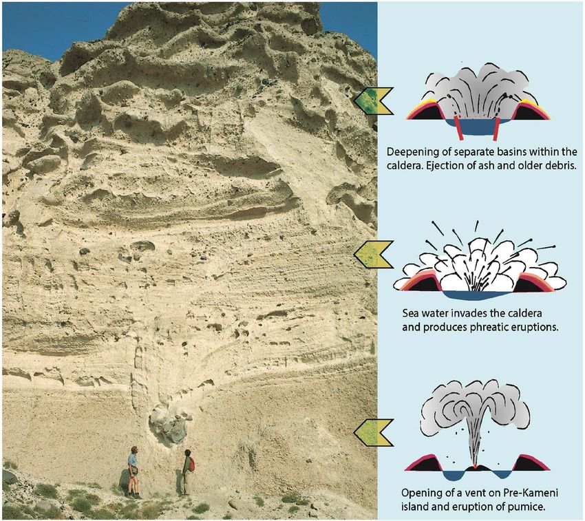
W. L. Friedrich et al.

                               newly found prehistoric ruins that had been discovered under the pumice on
                               Therasia. At that time Minoan pumice was being quarried on Thera and Thera-
                               sia and shipped to Egypt for construction of the Suez Canal (1859 to 1869).
                                 When the French geologist Fouqué visited Santorini for the first time in 1866,
                               he met a volcanic island that had experienced recent major changes. Pumice that
                               had been deposited by the Minoan eruption on the inner side of the Santorini
                               caldera was the first to be removed by this quarrying. This pumice removal led
                               to the loss of an enormous amount of geological and archaeological informa-
                               tion—a loss that led to wrong conclusions being made. In the 1870s Fouqué [7]
                               considered that the volcano had produced two distinct pumice units; the Upper
                               Pumice Series (ponce superieur) representing Minoan products) on the top of the
                               island and the Lower Pumice Series (ponce inferieur) that represented older erup-
                               tion products that were sandwiched between older and younger volcanic layers
                               (Figure 2). Fouqué [7] [8] considered that a volcano with a height of about 450 m
                               had existed in the central part of Santorini prior to the Minoan eruption.

                               2. Abandoning the Two Eruptions Concept
                               Fouqué’s two eruptions concept was supported by a detailed illustration of the
                               caldera walls by Neumann van Padang [9]. Since that time, the two eruptions
                               concept was implemented in geological maps by Pichler and Kussmaul [10] and
                               Druitt et al. [11]. Generations of geologists [12]-[18], including the senior author

                               Figure 2. Santorini caldera with Cape Alonaki in the left centre photographed in 1980.
                               The still active Karageorghis quarry is visible in the right centre. Pumice is clearly present
                               at two levels. Here Ferdinand Fouqué showed in 1879 the two pumice units (inserted
                               drawing with arrows pointing to the lower and upper pumice series) thus giving the im-
                               pression of two different eruptions. We now claim that both represent Minoan eruption
                               products that were deposited on two terraces on the caldera wall (Photo Friedrich).

DOI: 10.4236/ijg.2021.124018                          331                             International Journal of Geosciences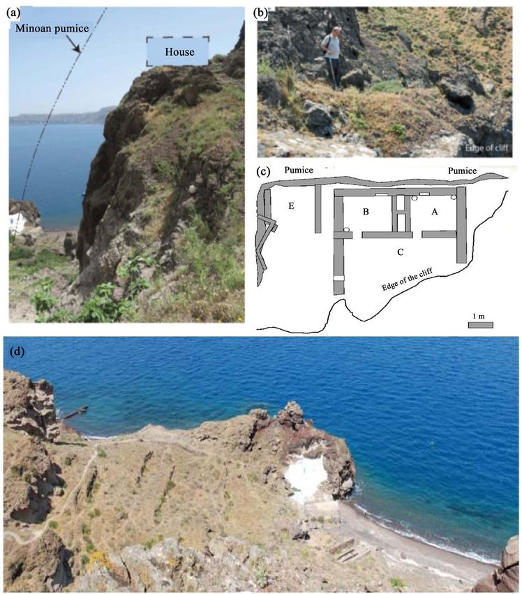
W. L. Friedrich et al.

                               (WLF), considered that the two apparent layers represented two different vol-
                               canic eruptions. This two eruptions concept spread to other areas in the Medi-
                               terranean where it was used in the interpretation of volcanic deposits found in
                               several deep-sea drillings. However, this concept was abandoned when chemical
                               analyses showed that the Lower Pumice Series encountered in the deep wells of
                               the Mediterranean was not from Santorini [19] but had an Italian source. This
                               was the beginning of a major change in the interpretation of the stratigraphy of
                               the Aegean area and Santorini [20]. Today we claim that the so-called Lower
                               Pumice Series does not exist (Figure 3). It is in fact part of a synchronous pumice

                               Figure 3. Schematic profiles through the caldera wall of Santorini. (a) Old concept with
                               two pumice series with different ages. (b) The synchronous Minoan pumice mantled the
                               entire caldera. (c) After erosion and extensive quarrying pumice only remains on terraces
                               on the caldera wall (Wilson/Friedrich). (d) Locations of places named in the text: (1)
                               Akrotiri excavation; (2) Balos excavation; (3) Raos excavation; (4) Kokkinopetra volcano;
                               (5) Mavro volcano/Mesa Pigadia; (6) Alafousos quarry; (7) Kimisi; (8) Skaros castle; (9)
                               Plaka. (e) Sites where pumice was loaded on to ships: (1) Alafousos; (2) Kimisi; (3) Balos;
                               (4) Mavromatis; (5) Plaka; (6) Karageorghis; (7) Fira; (8) Katofira; (9) Amudhi; (10) The-
                               rasia; (11) Manolas.

DOI: 10.4236/ijg.2021.124018                          332                            International Journal of Geosciences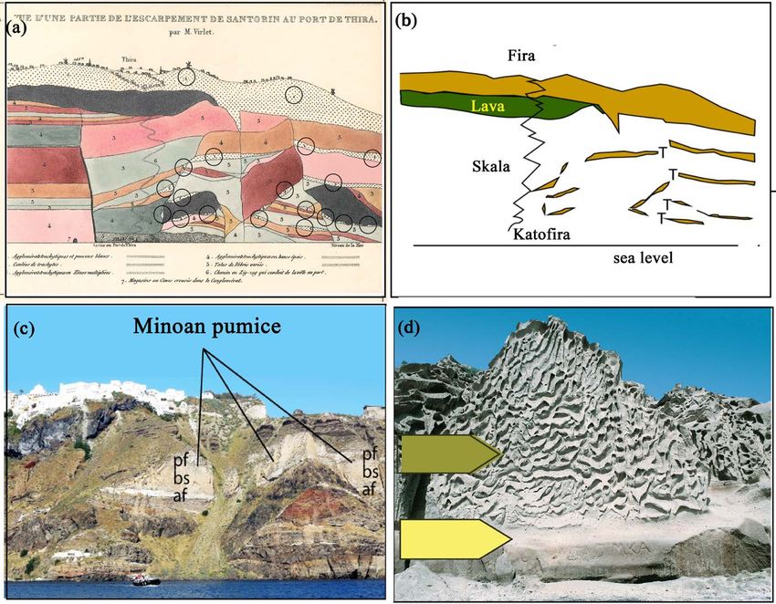
W. L. Friedrich et al.

                               mantle of the Minoan eruption remaining on terraces on the inner side of the
                               caldera wall, as will be shown below. Geologists, metaphorically speaking, grad-
                               ually “opened” the caldera more and more. The investigations of the above-
                               mentioned groups led to general acceptance that there existed a flooded caldera
                               prior to the Minoan eruption. This new development had some influence on in-
                               terpretations by archaeologists and of the landscapes depicted on the wall paint-
                               ings found in the Akrotiri excavation [21] [22] [23]. This development made it
                               possible to imagine that the naval procession depicted in the Ship Fresco could
                               have taken place in the flooded Santorini caldera [23].
                                 Furthermore, lithic material in the eruption products of the Minoan eruption
                               indicates that a so-called pre-Kameni island had existed in the water-filled Bronze
                               Age caldera roughly where the present-day Kameni islands are situated. A break-
                               through came in 1990 when the investigation of 1450 stromatolites (algae-bacterial
                               build-ups), some of them radiocarbon dated, revealed that a flooded caldera had
                               existed prior to the Minoan eruption [24]. This study of stromatolites that had
                               been ejected during the Minoan eruption led to general acceptance of the idea
                               that the caldera already existed prior to the eruption. Furthermore, numerous
                               marine fossils found embedded in the stromatolites compellingly prove that the
                               caldera was open and connected to the open sea, since the marine fossils needed
                               normal temperatures and salinity to propagate [25].
                                 Abandoning the idea of the existence of a high central volcano before the Mi-
                               noan eruption and acceptance of the presence of an open, water-filled caldera,
                               means that it should be possible to find large amounts of volcanic ash and pu-
                               mice from the Minoan eruption on the inner sides of the Santorini caldera walls.
                               Much of this material has, however, been removed by erosion and quarrying.
                               Moreover, the Akrotiri Peninsula consists of a volcano-tectonic block that is
                               confined on its margins by five volcanoes. Marine fossils found at Mount Arc-
                               hangelos indicate that this block has been uplifted by about 900 m. This devel-
                               oped zones of weakness along its margins, where magma rose and created the
                               volcanoes. The line between the volcanoes Kokkino-Petra and Balos on the
                               northern side of this block is the location of the current southern opening of the
                               caldera. This opening probably already existed in the Bronze Age, since the tec-
                               tonic movements here are much older than the Bonze Age. It therefore seems
                               unlikely that there was a pre-Minoan eruption caldera without a connection to
                               the open sea, as discussed by Karátson et al. [26].

                               3. Pumice Quarrying on Santorini
                                  and Its Consequences
                               Construction of the Suez Canal (1859 to 1869) led to enormous improvements in
                               world trade since the sea-route from Europe to SE Asia became much shorter.
                               There were also some unexpected consequences. On the Greek island group of
                               Santorini, prehistoric ruins were discovered when pumice of the Minoan erup-
                               tion (also called the Late Bronze Age eruption) was quarried on Therasia (Figure

DOI: 10.4236/ijg.2021.124018                        333                          International Journal of Geosciences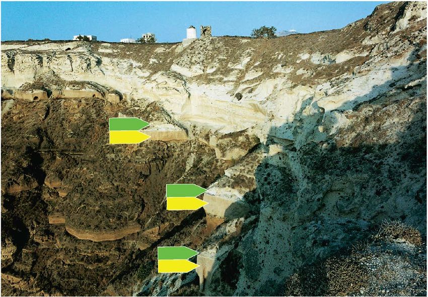
W. L. Friedrich et al.

                               3(d)) and shipped to Egypt. Several prehistoric ruins were found under the pu-
                               mice. On Thera—the main island—ruins were discovered at Akrotiri and above
                               Balos harbour. The latter locality was excavated by the French scholars Gorceix
                               and Mamet [27] where they found a prehistoric (later classified as Cycladic)
                               house (Figure 3(d) and Figure 3(c)) under a 22 m thick layer of pumice. Fou-
                               qué [7] presents a detailed description of these finds in his book. The use of pu-
                               mice as building material in the 1850s changed the look of the inner side of the
                               Santorini caldera. Pumice that had been deposited on terraces was the first to be
                               removed. Workers could easily move the material down to ships waiting below
                               (Figure 3(e)). A lengthy period of erosion and, not least, quarrying of the pu-
                               mice, has removed traces of it from many places on the steep caldera walls. 150
                               years of pumice quarrying on Thera and Therasia has left many scars in the
                               landscape. However, most of them are only visible for specialists, because where
                               pumice has been removed other volcanic material is now visible. Today the cal-
                               dera wall on Thera shows many signs of the quarrying and export of pumice.
                               There are the remains of several sites where ships were loaded with pumice on
                               the caldera wall (Figure 3(e)). There is a significant concentration of such sta-
                               tions on the caldera wall between Skaros castle and Balos harbour, where the
                               pumice deposits reached a thickness of about 60 m.

                               4. Terraces on Thera
                               Natural terraces are formed by wind or water erosion when layers with different
                               hardness are in contact with each other. Such terraces played a significant role
                               for prehistoric people since they could be used for shelters and as roads for both
                               people and animals. Natural terraces have been used by the inhabitants since
                               formation of the Santorini caldera that occurred during or after the Cape Riva
                               eruption (21 ka), as shown by the archaeological finds at Balos harbour (Cyclad-
                               ic house; Figure 4(b), Figure 4(c)) and Karageorghis quarry (Cycladic pottery).
                                 As in other volcanic areas the thick pumice cover on Santorini was used for
                               storage, houses, tunnels etc. An example of undiscovered tunnels appeared when
                               a heavily laden water-transporter crashed on the road close to the centre of Fira
                               on Santorini in 2015. This resulted in the roof of a medieval (or older) es-
                               cape-tunnel breaking under the weight of the truck and opened a window into
                               Santorini’s medieval history. In medieval times [28] a large bell at Skaros castle
                               was rung when pirates were seen in the caldera, and the inhabitants could hide
                               or escape through tunnels that were excavated in the Minoan pumice. This acci-
                               dent also solved a geological enigma. It provided important evidence in the
                               long-standing discussion concerning the two similar-looking pumice series on
                               the caldera wall [29]. Up to 2 km long tunnels (Table 1, four last measurements)
                               are only found in the “Upper Pumice Series” (for instance between the castle of
                               Pirgos and Charalombos church in the village Exo Gonia). There are no tunnels
                               in the “Lower Pumice Series”, and caves are only a few meters deep, because they
                               were dug into Minoan pumice mantle that remained on narrow terraces.

DOI: 10.4236/ijg.2021.124018                       334                         International Journal of Geosciences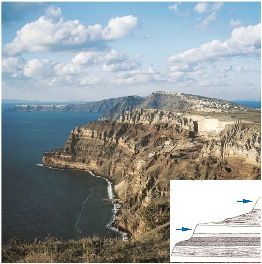
W. L. Friedrich et al.

                               Figure 4. (a) shows the Balos locality on top of a 16 m thick lava knoll on a terrace. (b)
                               The senior author is standing on the rediscovered platform where the house stood (Photo
                               L. Huber). (c) Plan of the prehistoric house (from Fouqué 1879). The small platform
                               where the Cycladic house was excavated in 1871 by Mamet and Gorceix is still visible. It
                               was covered by 22 m of pumice. (d) View from the platform showing Balos natural
                               double harbour (Photos: Friedrich, Katsipis).

                               Table 1. GPS data of localities on Santorini.

                                        Latitude     Longitude   Height m.a.s.l.                Locality

                                  1      36.3509      25.4028          3.2            Akrotiri excavation (entrance)

                                  2      36.4206      25.3327          77               Alafousos quarry Therasia

                                  4      36.226        25.4753         2.7                 Plaka, warm spring

                                  5      36.227        25.475          62                    Plaka, talc mine

                                  7      36.4132      25.4322         175.5           Phtellos excavation (Doumas)

                                  8      36.4095      25.4324         168.7           Phtellos excavation (Marthari)

                                  9      36.4001      25.4352         144.1           Karageorghis quarry (Pottery)

                                 10      36.3927      25.4383         216.7                  Two olive trees

                                 12      36.3691       25.209         132.3           Megalohori (unexcavated site)

DOI: 10.4236/ijg.2021.124018                          335                           International Journal of Geosciences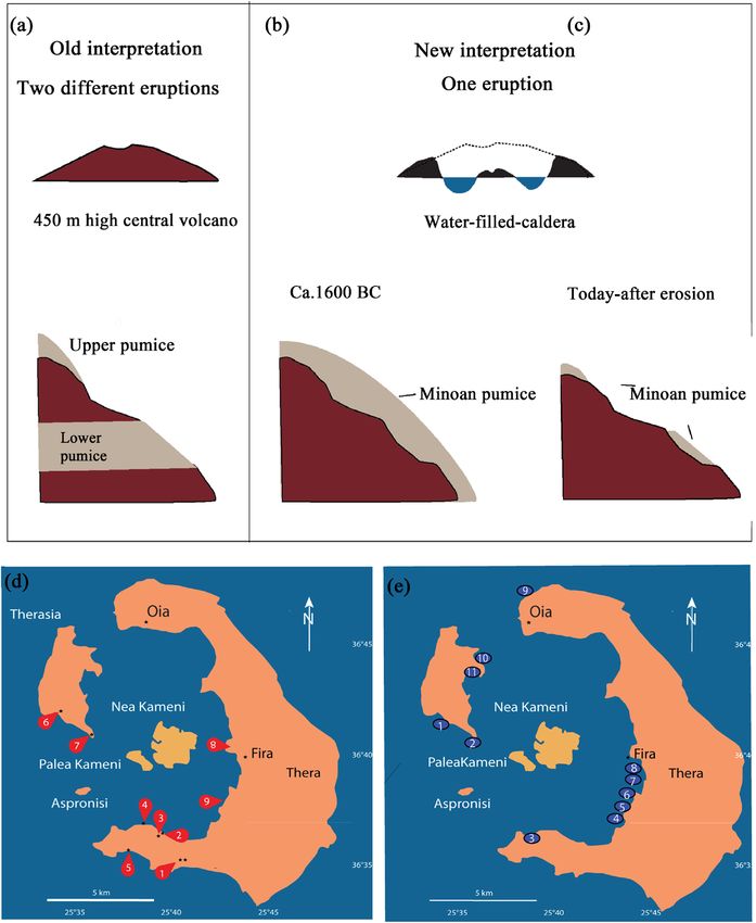
W. L. Friedrich et al.

                               Continued

                                 17     36.3630      25.3952      22.9            Balos left harbour basin (filled)

                                 18     36.3614      25.3903      164.5                   Raos excavation

                                 19     36.3624      25.3946      62.9                   Balos excavation

                                 20     36.2126      25.2289      168.9                    Archangelos

                                Tunnels on Thera

                                 21     36.3833      25.4507     391 ± 7        Tunnel 1. Start at Casteli of Pirgos

                                 22     36.3843      25.4524     360 ± 4            Tunnel 1. End at Sxo Gonia

                                 23     36.4183      25.4327     249 ± 7        Tunnel 2. Start at Fira Pelican hotel

                                 24     36.3843      25.4337     235 ± 7      Tunnel 2. End at Fira Bellonion Center

                                 The quarrying of pumice on Santorini had some negative consequences, such
                               as pumice dust storms that made working in the quarries temporarily impossi-
                               ble. For geologists, the removal of pumice provided fresh profiles with visible
                               geology, giving insight into the mechanism of the Minoan eruption. It was
                               straight forward to follow the deposits of the different eruption phases from
                               outcrop to outcrop.

                               4.1. A Cycladic House on a Terrace at Balos
                               Balos harbour is situated north east of the village Akrotiri. Two excavation sites
                               (Balos and Raos) above the harbour imply that it has been in use at least since
                               the Bronze Age. While Balos was excavated by French scholars in 1871, Raos was
                               not excavated until recently (2009 to 2012) by Marthari [30]. This harbour pro-
                               vides access to the water-filled caldera, which was connected to the open sea in
                               the Bronze Age through an opening between the Akrotiri Peninsula and Aspro-
                               nisi. Balos harbour (Figure 4 and Figure 5) was one of the places on Thera
                               where the pumice quarrying started in the 1850s [31]. Figure 5(c) shows how
                               pumice mining at that time began on the inner side of the caldera wall, where
                               pumice could easily be moved down to the waiting ships. A prehistoric house
                               was discovered on such a terrace at Balos which French scholars excavated in
                               1871. The right side of the same photograph shows the nearly intact preservation
                               of the pumice mantle of the Minoan eruption. This wall may have been spared
                               from quarrying because it would have damaged houses on the beach belonging
                               to fishermen. This wall shows remnants of pumice at three levels that remain af-
                               ter 3600 years of erosion. Figure 5(a) shows the same wall highlighted in the
                               evening sun. It reveals the characteristic details of the weathering pattern of the
                               base surge layers. Deposits of the Minoan eruption are clearly visible, indicating
                               that the synchronous pumice mantle originally covered the entire inner side of
                               the caldera wall.
                                 Minoan pumice is still visible at several levels on the caldera wall at Balos
                               harbour (Figures 5(a)-(c)). Neuman van Padang [9] was not able to locate the
                               prehistoric house above Balos harbour. When he mapped the “Lower Pumice

DOI: 10.4236/ijg.2021.124018                         336                        International Journal of Geosciences
W. L. Friedrich et al.
Figure 5. (a) The caldera wall at Balos harbour. Relics of the synchronous pumice mantle
of the Minoan eruption are visible at three levels (3 arrow pairs). The three pairs mark the
eruption products of the two first eruption phases (yellow arrow: air fall pumice; green
arrow: base surge deposits). The evening sun highlights pumice deposits that are lying on
three terraces at three levels. (b) A cross-section through pumice deposits (arrows) resting
on a terrace at Balos about 40 m asl. It is the same terrace where 10 caves are excavated in
the south and the remains of the Cycladic house are found to the north. (c) The black
rectangle at the top right shows the location of the Raos excavation (residential palace
excavated from 2009 to 2012 by Marisa Marthari). White rectangle: Cycladic house exca-
vated in 1871. The dashed line shows part of the terrace from which pumice has been re-
moved for construction of the Suez Canal. The white line shows the remnants of the pu-
mice mantle resting on a terrace. The ellipse shows the location of the monastery and the
10 caves dug into the Minoan pumice mantle. The pumice on the terrace here is 4.5 m
deep. The pumice level with the 10 caves extends to the left to the old excavation site at
Balos. Balos harbour is visible at the bottom left (Photos Friedrich, Katsipis).
Series” there he considered that all remnants of this house had already been re-
moved or eroded away. He was therefore not able to appreciate that this house
provided a maximum age for the pumice that buried it. Today, however, we are
aware of the site where the house stood (Friedrich, 2009) and are certain that it
was the Minoan eruption that buried it and not the “Lower Pumice Series”. Fur-
thermore, Cycladic objects found in the house are depicted in Fouqué’s book [7]
DOI: 10.4236/ijg.2021.124018 337 International Journal of GeosciencesW. L. Friedrich et al.
and are kept in the collections of the French school in Athens.
According to Simmonds et al. [32] LP2 has an absolute age of 154 ka. It is
clearly impossible that pumice of this age could have buried a Bronze Age house.
Even though the pumice here has been removed by quarrying it is reasonable to
claim that it was pumice from the Minoan eruption that buried the house and
not that from a much older eruption. Study of the geological setting around the
platform on top of the lava where the house stood [33] also indicates that the
pumice here had been deposited on a terrace and was not sandwiched between
older and younger layers.
The terrace where the house stood can be followed for several hundred metres
to the south. At some places it is still covered by the remains of Minoan pumice.
A total of 10 caves have been excavated and a monastery has been built in this
pumice. All the caves are only 4.50 metres deep since older deposits forming the
caldera wall in the Bronze Age were encountered at this depth. This strongly
supports the concept that this unit is not the product of an older pumice erup-
tion that covered the entire island.
4.2. Terraces and Pumice Mantle at Cape Plaka
Every geologist working on Santorini knows the Plaka profile (Figure 6). It
shows the whole sequence from the Minoan pumice on top overlying a sequence
of a variety of older non-volcanic products. Pumice originally draped the profile
but has largely been removed by quarrying, including the “Lower Pumice Se-
ries”. In the lower part of the profile there is an unconformity where volcanic
products overlie phyllites which extend down to sea level.
A few meters above the spring is a terrace where a few summerhouses are lo-
cated. It continues northwards for about 200 m. There is another terrace about
halfway up the caldera wall which has been used as a donkey trail down to the
harbour. These terraces were obviously covered by Minoan pumice some 150
years ago.
The unconformity on Santorini between phyllites and volcanizes that is ex-
posed at Cape Plaka and at the nearby Cape Thermia, where the Christos church
is located, might have been in use before the Minoan eruption. This can be de-
duced from the finding of pigments and lead minerals in the Akrotiri excavation
[34] which were probably collected from this area [35]. When quarrying re-
moved the pumice mantle the terrace became accessible again. The unconformi-
ty at Plaka is still inhabited; the Panaghia church and a summerhouse are located
on this terrace. At the nearby Thermia locality the Christos church is directly
built on the unconformity (Figure 7). The largest of three caves here is occupied
by the church and houses have been built in the other two. The church is still in
use but the two houses were abandoned a few decades ago.
4.3. Pumice Mantle and Terraces in Old Profiles
Scientific study of the Minoan eruption started around 1830 when the French
DOI: 10.4236/ijg.2021.124018 338 International Journal of GeosciencesW. L. Friedrich et al.
Figure 6. The upper part (ca. 60 m) of the Plaka profile on the steep caldera wall. Rem-
nants of the synchronous pumice mantle are visible at three levels (arrows) below the
windmills. Only the first two eruption phases have left deposits here (3 arrow pairs; yel-
low arrow: air fall pumice; green arrow: base surge deposits) (Photo Friedrich).
Figure 7. The caldera wall at Cape Thermia with the Christos church. The arrows mark
two levels with remnants of the synchronous pumice mantle of the Minoan eruption. The
level of the unconformity between phyllites and volcanites is shown by the dashed line.
The Christos church and two houses are built into three caves just above the unconfor-
mity. The white patch at the bottom left is hardened pumice, probably a relic of the Mi-
noan pumice mantle 2 arrow pairs; yellow arrow: air fall pumice; green arrow: base surge
deposits) (Photo Friedrich).
DOI: 10.4236/ijg.2021.124018 339 International Journal of GeosciencesW. L. Friedrich et al.
scientific Morea Expedition visited the Peloponnese, the Cyclades islands and
Santorini [36]. Among the scientists on the Morea Expedition was the geologist
M. Virlet. His profiles and drawings from 1834 show that the island had not yet
been affected by quarrying of the Minoan pumice. A coloured profile by Virlet
shows a section of the caldera wall below the town of Fira, down the zigzag road
to the harbour at Katofira (Figure 8(a)). Virlet’s drawing contains some impor-
tant details that are of interest for present-day researchers. His number 1 layer
represents a pumice layer which he recognized at several levels on the caldera
wall. These pumice layers are emphasized in Figure 8(b). At least four
sub-horizontal pumice-covered terraces can be recognised. The sloping units of
pumice are resting on faults or joint systems. They may have provided access
between the different terraces in the Bronze Age. We can identify this pumice as
representing the Minoan pumice mantle. The uppermost pumice at the top of
Figure 8(a) and Figure 8(b) has a variable thickness. On the left (north) it over-
lies the uppermost lava flow of the Skaros Lava Series, and on the right (south) it
is up to twice as thick as on the left. The abandoned Fira pumice quarry is visible
Figure 8. (a) Geological profile of the caldera wall below Fira by Virlet in 1834. White
pumice outcrops marked by circles (ponceaux blanc in his legend) form the uppermost
unit (which he labelled number 1). (b) Interpretation of Virlet’s drawing shows that at
least four terraces (T) are present below the town of Fira which most likely were accessi-
ble in the Bronze Age. (c) Photo (from 2016) of the caldera wall below Fira (top left) for
comparison with the drawing by Virlet in (a). af = air fall; bs = base surge; pf = pyroclastic
flow. (d) Weathering patterns of the first two phases of the Minoan eruption on the outer
slope of the volcano south of Akrotiri. Erosion by wind and water has produced a
wave-like pattern on the surface of the base surge unit (centre). Depending on the angle
of sunlight the surface seems to be darker than it really is (yellow arrow: air fall pumice;
green arrow: base surge deposits) (Photos Friedrich).
DOI: 10.4236/ijg.2021.124018 340 International Journal of GeosciencesW. L. Friedrich et al.
at the top right centre in Figure 8(c). The pumice here is believed to originally
have extended to the edge of the caldera wall, as implied by Virlet’s drawing.
Huge amounts of pumice have been quarried away from this locality, as can be
deduced by comparing the photo with Virlet’s drawing. The pumice here was up
to 60 m thick. The whitish outcrop near the centre of the photo represents the
Minoan pumice mantle in which the three classic units representing air fall, base
surge and pyroclastic flow can be recognized. In Virlet’s drawing this is shown as
the dark grey unit in the lower centre (indistinctly labelled as number 2; “Cou-
lees de trachytes”). He identified the white layers at the top and base as pumice
but not the central base surge unit. This may well have been because of its
off-white colour. The same pumice unit is shown by Virlet as thick brown and
dark grey areas in the right part of his drawing.
The pumice at the top of Figure 8(a) and Figure 8(c) would be interpreted as
representing the “Upper Pumice Series” and the centrally located pumice, la-
belled af, bs and pf, the “Lower Pumice Series” by earlier workers. We now con-
sider that both the “Upper” and “Lower Pumice Series” belong to the Minoan
eruption. In some places the so-called “Lower Pumice Series” has a slightly
darker colour than the upper unit, which was one of the arguments for the two
eruptions concept. However, the darker colour is caused by dark lapilli, which
locally occur above the lower unit. The lapilli have been washed down by rain-
water, giving rise to a dark coating on the outcrop. Furthermore, a characteristic
weathering pattern of the base surge deposits commonly results in a darker im-
pression of the surface (Figure 8(d)). Where recent erosion (or excavation) has
removed the dark coating, the original whitish colour of the base surge unit is
again visible.
4.4. Pyroclastic Relicts on Analfi Island
Anafi is a non-volcanic island situated about 30 km east of Santorini. Relicts of
Minoan pumice were reported on Anafi [15] [37] by Keller (1981). Furthermore,
Doumas & Papazoglou [38] reported vestiges of Minoan pumice from both Ana-
fi and Rhodes. It is important to establish the age of these deposits and whether
they come from Santorini. Gertisser et al. [39] reported that pumice on Anafi
could represent “Lower Pumice 2” (LP2 with a supposed age of 154 ka). Keller et
al. [40] reported, based on chemical analyses, that the LP2 pumice is present on
Anafi. However, an OSL study by Theodorakopoulou et al. [41] showed that no
traces of pumice older than 21 k years were present on Anafi. This result sup-
ports the non-existence of the “Lower Pumice Series”, at least on Anafi. Howev-
er, more investigations on both Santorini and Anafi are necessary to shed further
light on this issue.
5. Historic Eruptions
The discovery of the pumice mantle on the inner side of the caldera solves some
stratigraphic problems. However, it is important to realise that there were some
DOI: 10.4236/ijg.2021.124018 341 International Journal of GeosciencesW. L. Friedrich et al.
more recent eruptions that could have left volcanic deposits on the inner and
outer walls. Two eruptions that produced enormous amounts of pumice are par-
ticularly relevant. These are the eruptions in AD 726 on Palea Kameni and the
AD 1649-1650 eruption of the Kolumbos submarine volcano, about 7 kilometres
NE of Santorini. Pumice from the AD 726 eruption was reported from as far
away as Abydos in the Dardanelles and on the coast of Macedonia. The oldest
reports of the AD 726 eruption are given by Nicephoros (758-823): “The whole
sea was filled with floating pumice”. The vent of this eruption was obviously on
Palea Kameni where relicts of pumice can be found in fissures. There are, how-
ever, no known traces of pumice from this historic eruption on Thera or Thera-
sia. In this respect the AD 726 eruption resembles that of the submarine Ko-
lumbos volcano. A large quantity of pumice was produced by the Kolumbus
eruption that filled the sea around Santorini and left traces of pumice on the
coast. However, subsequent erosion by the sea, including tsunamis, has removed
most of it.
6. Conclusions
The discovery of a synchronous pumice mantle on the caldera wall shows that
the Minoan eruption deposited considerable amounts of pumice on the inner
side of the Santorini caldera. However, a lengthy period of erosion and 150 years
of pumice quarrying led to the loss of an enormous amount of geological and
archaeological information. Our find of relicts of a synchronous pumice mantle
that remained on several terraces on the caldera wall shows that it originally
covered the entire caldera wall down to sea level. Field observations at Balos,
Plaka, Thermia and Katofira are supported by a geological profile from 1834 that
shows Santorini before it was affected by pumice quarrying. The finding of a
synchronous pumice mantle from the Minoan eruption gives rise to new inter-
pretations of the stratigraphy and geological concepts. The ages of LP1 (ca.
172,000 years) and LP2 (ca. 154,000 years) are no longer relevant because they
provide ages of the sampling sites on the caldera wall upon which the pumice
mantle was deposited but not of the pumice itself.
Many researchers have noted that the “Lower Pumice” is remarkably similar
to the “Upper Pumice”, but have nevertheless considered that they were pro-
duced by two eruptions separated by up to 172 k years. We claim that these two
pumice units are identical. Both represent products of the synchronous pumice
mantle produced by the Minoan eruption. The three classic phases (Figure 1) of
the Minoan eruption are visible in both the “Upper” and “Lower Pumice Series”.
The chemical compositions of the two pumice units are also remarkably similar
[29], including the rare earth diagrams [42]. Furthermore, archaeological find-
ings below the “Lower Pumice” at two localities (Karageorghis quarry and Balos)
show that these sites were buried by the synchronous pumice mantle of the 3.6
ka Minoan eruption and not by pumice with an age of some 170,000 years. For
these reasons, the two eruptions concept should be discarded.
DOI: 10.4236/ijg.2021.124018 342 International Journal of GeosciencesW. L. Friedrich et al.
To summarize, our main conclusions are:
1) After the Minoan eruption, pumice mantled the entire inner side of the
Santorini caldera;
2) There was only one major eruption that took place in the Bronze age (about
3.6 ka ago) and not two separated by about 150,000 years;
3) The so-called “Lower Pumice Series” does not exist on Santorini. Like the
“upper Pumice Series” it is part of the Minoan eruption;
4) The inner side of the Santorini caldera had several natural terraces prior to
the Minoan eruption. The pumice came to rest on these terraces. Much of it has
been removed by quarrying and erosion;
5) Archaeological finds of Cycladic ruins and pottery prove that the inner side
of the Santorini caldera was inhabited during the Bronze age.
Acknowledgements
We are grateful to Georgios Nomikos for help with transportation and Michael
and Jeppe Friedrich for help with the fieldwork. Kirsten Molly Søholm and
Kirsten Gomard helped with the manuscript and Grethe Storgaard with the illu-
strations.
Conflicts of Interest
The authors declare no conflicts of interest regarding the publication of this paper.
References
[1] Fouqué, F. (1869) Une Pompéi Antéhistorique. Revue des deux mondes, 83, 923-942.
[2] Friedrich, W.L. (2000) Fire in the Sea. Cambridge University Press, Cambridge, 258.
[3] Marinatos, S. (1976) Excavations at Thera VII. Bibliotheke tes en Athenais Archai-
ologikes Hetaireios, Athens.
[4] Palyvou, C. (2005) Akrotiri, Thera: An Architecture of Affluence 33,500 Years Old.
Prehistory Monographs, INSTAP Academic Press, Athens.
https://doi.org/10.2307/j.ctt3fgvrh
[5] Doumas, C. (1992) The Wall Paintings of Thera. The Thera Foundation, Athens.
[6] Friedrich, W.L. (2013) The Minoan Eruption of Santorini around 1613 BC and Its
Consequences. Tagung en des Landesmuseums für Vorgeschichte Halle, 9406.
[7] Fouqué, F. (1879) Santorin et ses Éruptions. Masson & Cie, Paris.
[8] Fouqué, F. (1998) Santorini and Its Eruptions. Translated and Annotated by A. R.
McBirney. Johns Hopkins University Press, Baltimore.
[9] Neumann van Padang, M. (1936) Die Geschichte des Vulkanismus Santorins von
ihren Anfängen bis zum zerstörenden Bimssteinausbruch um die Mitte des 2. Jahr-
tausend vor Christus. In: Reck, H., Ed., Santorin-der Werdegang eines Inselvulkans
und sein Ausbruch 1925-1928, Vol. I, D. Reimer, Berlin, 1-72.
[10] Pichler, H. and Kussmaul, S. (1980) Geological Map of the Santorini Islands, (1:20
000) Appendix to: Thera and the Aegean World II. The Thera Foundation, London.
[11] Druitt, T.H., Edwards, R.M., Mellors, D.M., Pyle, D.M., Sparks, R.S.J., Lanphere, M.,
Davies, M. and Barriero, B. (1999) Santorini Volcano. Geological Society Memoir
19. 165.
DOI: 10.4236/ijg.2021.124018 343 International Journal of GeosciencesW. L. Friedrich et al.
[12] Ninkovich, D. and Hays, J.D. (1967) Mediterranean Island Arcs and Origin of High
Potash Volcanoes. Earth and Planetary Science Letters, 16, 331-345.
https://doi.org/10.1016/0012-821X(72)90151-3
[13] Druitt, T.H. and Francaviglia, V. (1992) Caldera Formation on Santorini and the
Physiogeography of the Islands in the Late Bronze Age. Bulletin Volcanologique,
54, 484-493. https://doi.org/10.1007/BF00301394
[14] Pichler, H. and Friedrich, W.L. (1976) Radiocarbon Dates of Santorini Volcanics.
Nature, 62, 373-374. https://doi.org/10.1038/262373a0
[15] Keller, J. (1981) Quaternary Tephrochronology in the Mediterranean Region. In:
Self, S. and Sparks, R.S.J., Eds., Tephra Studies NATO Advanced Study Institutes
Ser. C, Vol. 75, D. Reidel Publishing Co., Dordrecht/Boston, 227-244.
https://doi.org/10.1007/978-94-009-8537-7_14
[16] Sparks, R.S.J. and Wilson, C.J.N. (1990) The Minoan Deposits: A Review of Their
Characteristics and Interpretation. In: Hardy, D.A., Ed., Thera and the Aegean
World II, Vol. 2, The Thera Foundation, London, 89-99.
[17] Pichler, H. and Friedrich, W.L. (1980) Mechanism of the Minoan Eruption of San-
torini. In: Doumas, C., Ed., Thera and the Aegean World II, The Thera Foundation,
London, 15-30.
[18] McCoy, F.W. (2009) The Eruption within the Debate about the Date. Time’s Up
Acts of the Minoan Eruption Chronology Workshop, Sandbjerg, November 2007,
71-89.
[19] Bond, A. and Sparks, R.S.J. (1976) The Minoan Eruption of Santorini, Greece.
Journal of the Geological Society of London, 132, 1-16.
https://doi.org/10.1144/gsjgs.132.1.0001
[20] Friedrich, W.L., Sørensen, A.H., Wilson, J.R., Fytikas, M., Pavlides, S. and Katsipis,
S. (2017) A Major Change in the Stratigraphy of the Santorini Volcano in Greece.
International Journal of Geosciences, 8, 767-780.
https://doi.org/10.4236/ijg.2017.86043
[21] Morgan, L. (1988) The Miniature Wall Paintings of Thera. A Study in Aegean Cul-
ture and Iconography. Cambridge University Press, Cambridge.
[22] Friedrich, W.L. and Doumas, C.G. (1990) Was There Local Access to Certain
Ores/Minerals for the Theran People before the Minoan Eruption? An Addendum.
In: Hardy, D.A., Ed., Thera and the Aegean World III, Vol. 1, The Thera Founda-
tion, London, 502-503.
[23] Sørensen, A.H., Friedrich, W.L. and Søholm, K.M. (2018) Metamorphoses and Hy-
bridity in the Wall-Paintings at Akrotiri, Thera. In: Vavouranakis, G., Kopanias, K.
and Kanellopoulos, C., Eds., Popular Religion and Ritual in Prehistoric and Ancient
Greece and the Eastern Mediterranean, Archaeopress Archaeology, Oxford, 47-54.
https://doi.org/10.2307/j.ctvndv50x.10
[24] Eriksen, U., Friedrich, W.L., Buchardt, B., Tauber, H. and Thomsen, M.S. (1990)
The Stronghyle Caldera: Geological, Palaeontological and Stable Isotope Evidence
from Radiocarbon Dated Stromatolites from Santorini. In: Hardy, D.A., Ed., Thera
and the Aegean World, Vol. III, The Thera Foundation, London, 2, 139-150.
[25] Friedrich, W.L., Eriksen, U., Tauber, H., Heinemeier, J., Rud, N., Thomsen, M.S.
and Buchardt, B. (1988) Existence of a Water-Filled Caldera Prior to the Minoan
Eruption of Santorini, Greece. Naturwissenschaften, 75, 567-569.
https://doi.org/10.1007/BF00377720
[26] Karátson, D., Telbisz, T., Gertisser, R., Strasser, T.I., Nomikou, P., Druitt, T., Vereba,
DOI: 10.4236/ijg.2021.124018 344 International Journal of GeosciencesW. L. Friedrich et al.
V., Quidelleur, X. and Kósik, S. (2020) Constraining the Landscape of Late Bronze
Age Santorini Prior to the Minoan Eruption: Insights from Volcanological, Geomor-
phological and Archaeological Findings. Journal of Volcanology and Geothermal Re-
search, 401, Article ID: 106911.
https://doi.org/10.1016/j.jvolgeores.2020.106911
[27] Gorceix, H. and Mamet, C. (1871) Constructions de l’époque antéhistorique, dé-
couvertes à Santorin. Comptes Rendus, 73, 476-478.
[28] Gorée, F. (1712) A Relation of a New Island, Which Was Raised Up from the Bot-
tom of the Sea, on the 23d of May 1707, in the Bay of Santorini, in the Archepelago.
Philosophical Transactions, 27, 354-375.
[29] Günther, D. and Pichler, H. (1973) Die Obere und Untere Bimsstein-Folge auf
Santorin. Neues Jahrbuch für Geologie und Paläontologie, 7, 394-415.
[30] Marthari, M. (2017) Investigating the Outskirts of the Prehistoric Town at Akrotiri,
Thera. Α Rich LC I/LM IA Building Complex at the Site of Raos.
[31] Tzachili, I. (2005) Excavations on Thera and Therasia in the 19th Century. A Chroni-
cle. Journal of Mediterranean Archaeology, 18, 231-257.
https://doi.org/10.1558/jmea.2005.18.2.231
[32] Simmonds, J.M., Carey, R.J. and Cas, R. (2017) High Magma Decompression Rates
at the Peak of a Violent Caldera-Forming Eruption (Lower Pumice 1 Eruption,
Santorini, Greece). Bulletin of Volcanology, 79, 42.
https://doi.org/10.1007/s00445-017-1120-1
[33] Friedrich, W. L. (2009) Santorini, Volcano, Natural History and Mythology. Aarhus
University Press, Aarhus.
[34] Michailidou, A. (1990) The Lead Weights from Akrotiri: The Archaeological Record.
In: Thera and the Aegean World III, Vol. 1, The Thera Foundation, London, 407-418.
[35] Rasmussen, S.E., Grundvig, S. and Friedrich, W.L. (2004) Composition of Pigments
of Santorini Frescoes: The Rietveld Method as an Aid in Qualitative Phase Analysis.
Powder Diffraction, 1145-1149. https://doi.org/10.1154/1.1643052
[36] Bory de Saint-Vincent, J.B. (1834) Expédition scientifique de Morée. Section des
sciences physiques, tome II Géographie et géologie.
[37] McCoy, F.W. and Dunn, S. (2002) Modelling the Climatic Effects of the LBA Erup-
tion of Thera: New Calculations of Tephra Volumes May Suggest a Significantly
Larger Eruption than Previously Reported (Abstract). In: Proceedings of the Chap-
man Conference on Volcanism and the Earth’s Atmosphere, American Geophysical
Union, Santorini, 21-22.
[38] Doumas, C. and Papazoglou, L. (1980) Santorini Tephra from Rhodes. Nature, 287,
322-332. https://doi.org/10.1038/287322a0
[39] Gertisser, R., Preece, K. and Keller, J. (2009) The Plinian Lower Pumice 2 Eruption,
Santorini, Greece: Magma Evolution and Volatile Behaviour. Journal of Volcanolo-
gicaal and Geothermal Research, 186, 387-406.
https://doi.org/10.1016/j.jvolgeores.2009.07.015
[40] Keller, J., Gertisser, R., Reusser, E. and Dietrich, V. (2014) Pumice Deposits of the
Santorini Lower Pumice 2 Eruption on Anafi Island, Greece: Indications for a Pli-
nian Event of Exceptional Magnitude. Journal of Volcanologicaal and Geothermal
Research, 278, 120-128. https://doi.org/10.1016/j.jvolgeores.2014.04.009
[41] Theodorakopoulou, K., Kyriakopoulos, K., and Stamoulis, K., Rizza, M., Athanassas,
C.D., Sulpizio, R. and Alcicek, M.C. (2019) Chronological Evidence for a Pre-Minoan
Age of Pyroclastic Deposits on Anafi Island, Cyclades, Greece. Mediterranean
DOI: 10.4236/ijg.2021.124018 345 International Journal of GeosciencesW. L. Friedrich et al.
Geoscience Reviews, 1, 17-24. https://doi.org/10.1007/s42990-019-00005-5
[42] Vitaliano, C.J., Norman, M.D., McCulloch, M.T. and Nicholls, I.A. (1990) Ash Lay-
ers of the Thera Volcanic Series: Stratigraphy, Petrology and Geochemistry. In:
Hardy, D.A., Keller, Galanopoulos, V.P., Flemming N.C. and Druitt, T.H., Eds.,
Thera and the Aegean World III, Volume Two, Earth Sciences, The Thera Founda-
tion, London, 53-78.
DOI: 10.4236/ijg.2021.124018 346 International Journal of GeosciencesYou can also read