Technical Interchange Teleconference between NOAA, JMA and BOM 7th April 2020 23UTC - Cooperative Institute for ...
←
→
Page content transcription
If your browser does not render page correctly, please read the page content below
Technical Interchange Teleconference between
                NOAA, JMA and BOM
                7th April 2020 23UTC

1. AOMSUC-10 Training Event feedback pertaining to satellite
   data use, data requirements and training.

2. Examination of GEO-KOMPSAT-2A and Himawari-8 Rapid
   Scan imagery as applied to south-eastern Australian case
   study of the 31 January 2020

                            Bodo Zeschke
      Teacher Australian Bureau of Meteorology Training Centre
        Point of Contact Australian VLab Centre of Excellence
                     bodo.zeschke@bom.gov.au
AOMSUC-10 Training Event Socrative question and
feedback summary, with particular emphasis on Satellite
              data use by attendees

                   Bodo Zeschke BMTC
                     (image courtesy Stephen Gillespie)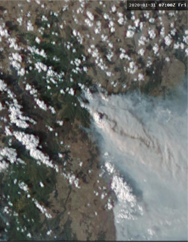
AOMSUC-10 Training Event, showing the sessions where Socrative
                          was used
   Local time /session           Monday, 2nd December 2019                              Tuesday, 3rd December 2019
          0830           Welcome session                                        A panel led discussion pertaining to how and
       (session 1)                                                              where to access the satellite data

          0915           Spectral bands and their uses                        Introduction to the WMO Space-Based Weather
       (session 2)                                                            and Climate Extremes Monitoring Demonstration
                                                                              Project
          1000           Morning tea /Photo                                   Morning tea
          1030           Application of the spectral bands to RGB composites Group discussions that consolidate the content of
       (session 3)                                                            the previous sessions. Experts to mentor the
          1115           Introduction to now-casting using satellite data and groups.
       (session 4)       products: Tropical storm and Typhoon examples

          1200           Introduction to now-casting using satellite data and
       (session 5)       products: Thunderstorm examples

              1245       Lunch                                                  Lunch

          1400           Introduction to now-casting using satellite data and   13:30 to 14:30 LST. VLab Regional Focus
       (session 6)       products: Precipitation examples.                      Group (RFG) Weather presentation.
          1445           Nowcasting applications using GEO-KOMPSAT-2A           A chaired post RFG discussion.
       (session 7)       data and RGB products
          1530           Afternoon break                                        Afternoon break
          1600           Spectral band / now-casting exercise with a short      Future developments: utilizing data from multiple
       (session 8)       example or two using RAMMB/CIRA SLIDER                 satellite platforms.

          1645           Spectral band / now-casting exercise with examples     Summary session including evaluation and review
       (session 9)       using SATAID                                           of the Training Event.
          1730           Finish                                                 Finish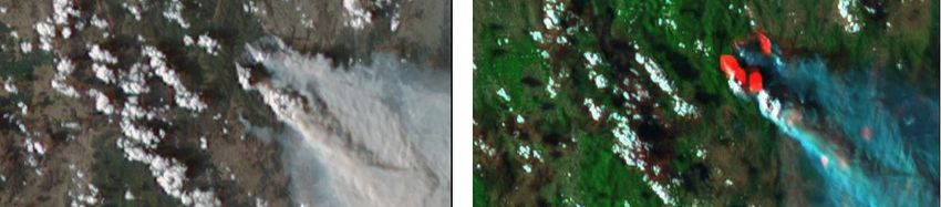
AOMSUC-10 Training Event Socrative Surveys
                   Main topics

1. Participant's familiarity with the Socrative cloud based
   learner response system.
2. The profile of the participants with respect to their satellite
   meteorology work.
3. Satellite projects, satellite data and data viewers
4. The use and availability of RGB composites
5. The use of satellite data in detecting and monitoring
   convection
6. The use of data from multiple satellites
7. The activities of the Australian VLab Centre of Excellence.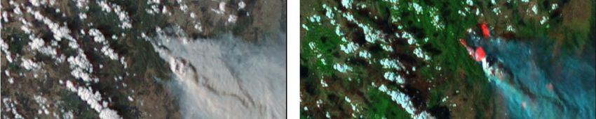
AOMSUC-10 Training Event
question: "Which of these
options best describe your
         work?".
                             (image courtesy Stephen Gillespie)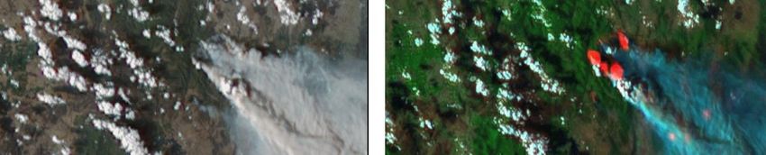
"What functionality would you most like to see on SLIDER?"
 Related to the computer platform and its capabilities
 1. It should be on a GIS platform
 2. Ability to load satellite, observational data such as weather RADAR and NWP
    from the local PC.
 3. Job scheduler with automatic download to specific official organization website.
 4. Should be able to download the data into geoTIFF format.
 5. An easily accessible archive of past data
 Display of the data
 1. The ability to change the projections of the imagery
 2. Ability to rotate the earth within the display window
 3. Ability to choose (zoom into) a specific subsector in the display such as a region
    or a country.
 4. Ability to permit "limb viewing" of the atmosphere at the edge of the full disk
    earth image for satellites other than Himawari-8
 5. Rocking animation
 6. The slider function that permits side by side comparison of different display
    layers. See also https://rammb-slider.cira.colostate.edu/ , specifically the Slider
    option.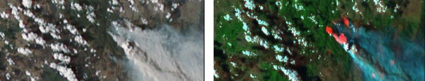
"What functionality would you most like to see on SLIDER?"

 Data details revealed
 1. Information such as latitude and longitude and the value of the parameters of
    the display layers to be available whilst scrolling the mouse over the image
    display.
 2. For the "Follow Feature" function on the web site https://rammb-
    slider.cira.colostate.edu/ one attendee would like to see the latitude and
    longitude information so that the monitoring of storm and Tropical Cyclone
    movement can be more accurate.
 Data from other satellites
 1. Attendees would like to see a display that includes a wide range of satellite data,
    including GEO-KOMPSAT-2A, Fengyun-4A, the INSAT and polar orbiting satellites.
 Creating new composites / manipulating existing composites
 1. Ability to create RGB composites using selected bands, image differences and
    gamma corrections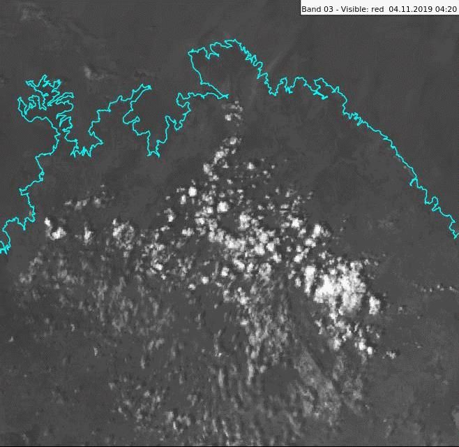
"What functionality would you most like to see on SLIDER?"

 Multilayered data
 1. Weather RADAR overlay
 2. Other observational data overlay
 3. Cloud drift winds
 4. Lightning data that can be superimposed onto visible and infrared data. Lightning
    data from the GOES satellite. Lightning data over the Indian Ocean
 5. Scatterometer (ASCAT) data processed in near real time.
 6. Other microwave sensors
 7. Addition of Level 2 satellite products (Geophysical quantity retrieved from single
    instrument data in original instrument projection Note: For example,
    temperature, humidity, radiative flux see
    http://www.wmo.int/pages/prog/sat/dataandproducts_en.php )
 8. Quantitative Precipitation Estimate (QPE) data
 9. Overlaying with NWP model outputs
 10.Predefined products (what is meant by this)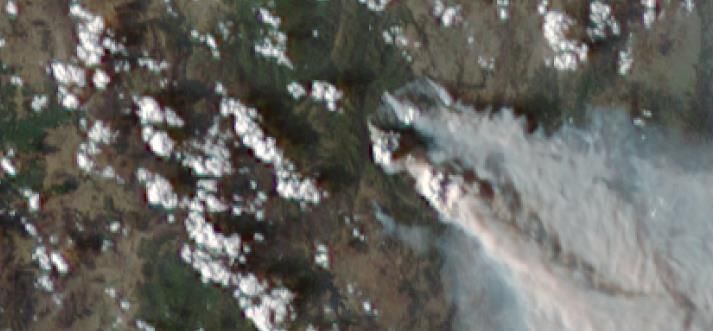
satellite images courtesy JMA/BOM

                AOMSUC-10 Training Event question: "Which RGB
                 composites do you use most during your work".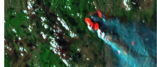
AOMSUC-10 Training Event question: "What data is most
important when you are monitoring the development of
                  thunderstorms".

               satellite images courtesy JMA/BOM, lightning data courtesy WeatherZone
AOMSUC-10 Training Event question: "Have you examined
the archived recordings of the Regional Focus Group
meetings?".
http://www.virtuallab.bom.gov.au/archive/regional-focus-group-recordings/AOMSUC-10 Training Event question: "Have you used Australian
VLab Centre of Excellence resources in your work ?".Report The report "AOMSUC Training Event Socrative Surveys result summary" has been submitted to a Bureau Training Event coordinator for comment and anticipating further feedback
http://www.virtuallab.bom.gov.au/index.php/download_file/
                      view/1508/278/
0710UTC 0720UTC 0730UTC 0740UTC
0712UTC   0710UTC

0718UTC   0720UTC

0730UTC   0730UTC

0736UTC   0740UTC
Comparison between FY-4A, GEO-KOMPSAT-2A and
      Himawari-8 data, 07UTC 31st January 2020

FY-4A True Colour RGB   GEO-KOMPSAT-2A Band 3   Himawari-8 True Colour RGB

            FY-4A data at http://rsapp.nsmc.org.cn/geofy
You can also read