TEMPERATE GRASSLANDS OF SOUTH AMERICA - Prepared for The World Temperate Grasslands Conservation Initiative Workshop Hohhot, China - June 28 & 29 ...
←
→
Page content transcription
If your browser does not render page correctly, please read the page content below
TEMPERATE GRASSLANDS
         OF
    SOUTH AMERICA

                         Prepared for
The World Temperate Grasslands Conservation Initiative Workshop
              Hohhot, China - June 28 & 29, 2008

                 Compiled by Andrea Michelson
            TGCI South America Regional Coordinator
                andrea.michelson@sur.iucn.org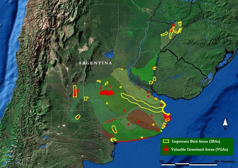
INDICE

Northern Andes Grasslands ........................................................................................ 3

Central and High Andean Grasslands. .................................................................... 12

Río de la Plata Grasslands. ....................................................................................... 24

Patagonia Steppe........................................................................................................ 34

                                                                                                                         2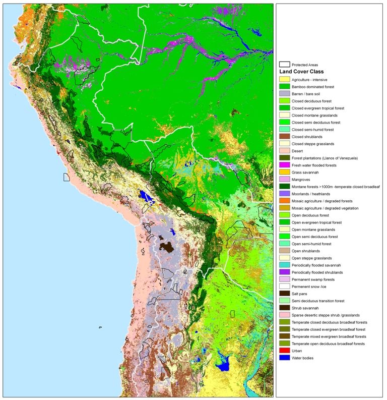
TEMPERATE GRASSLANDS OF SOUTH AMERICA

1 Páramo or Northern Andes (Venezuela, Colombia, Ecuador, northern Perú)

       Authors: Francisco Cuesta C.1 & De Bievre, Bert.1
       (1). Consorcio para el Desarrollo Sostenible de la Ecorregión Andina (CONDESAN). http://www.condesan.org
       F.Cuesta@cgiar.org ; B.DEBIEVRE@CGIAR.ORG

       Presentation in Hohhot: Andrea V. Michelson2 & Robert Hofstede2
       (2) UICN Sur. Calle Quiteño Libre E12-15 y la Cumbre. Quito, Ecuador. andrea.michelson@sur.iucn.org

1.1 Major indigenous temperate grassland types

The tropical Andes region tops the list of worldwide hotspots for endemism and species/area ratio
(Myers et al. 2007). A major contributor to the rich biodiversity and endemism of the tropical Andes
is the páramo, a neotropical alpine ecosystem covering the upper parts of the tropical Andes from
Venezuela south to northern Peru (6°30” S). Two isolated systems are located in the Sierra Nevada
de Santa Marta in Colombia and in Costa Rica.

The páramo extends between the upper tree line and the perennial snow border (about 3200 - 5000 m
altitude) reflecting a sort of island archipelago. Its total area is estimated at 35770 km2 (Josse et al.
2008). The isolated and fragmented occurrence of tropical mountain wetlands promotes high
speciation and an exceptionally high endemism at the species and genera level (Sklenář and Ramsay
2001). At the regional and landscape scales, factors such as climate, geological history, habitat
diversity and also human influence determine páramos´ biota diversity (Simpson 1974; Vuilleumier
and Monasterio 1986; Luteyn 1992). Local climatic gradients further complicate within-mountain
diversity patterns, with spatial community changes often occurring over short distances (Cleef 1981;
Ramsay 1992; Sklenář and Balslev 2005). The páramo ecosystem hosts 3595 species of vascular
plants distributed in 127 families, and 540 genera (Sklenar et al. 2007). About , 14 of these genera
and 60% of these species are endemic to the Northern Andes (Luteyn 1999), and adapted to the
specific physio-chemical and climatic conditions, such as the low atmospheric pressure, intense
ultra-violet radiation, and the drying effects of wind (Luteyn et al. 1992).

The physiognomy of tropical alpine vegetation varies within and between regions but certain features
are shared such as similar growth forms of the dominant plants (Coe 1967; Cleef 1978; Cuatrecasas
1968; Hedberg 1964; Monasterio & Vuilleumier 1986; Smith 1994; Smith 1977; Smith & Young
1987). Previous works that describe the páramo vegetation (i.e. Acosta-Solis 1986; Cuatrecasas
1958; Harling 1979; Cleef 1981; Acosta-Solís 1984; Ramsay 1992; Jørgensen y Ulloa 1994) define
three main páramo units above the treeline, according to the physiognomy and structure of the
vegetation: (1) the sub-páramo or shrub páramo, (2) grass páramo or pajonal – frequently dominated
by stem rosettes of the genus Espeletia or Puya - and (3) super-páramo. Polylepis woodlands,
probable remnants of more extensive upper Andean forest in the past (Fjeldså 1992; Lægaard 1992),
also contribute to the mosaic of páramo habitats

The sub-páramo covers the ecotone between the transition of the upper montane forest and the
treeline, and in many cases is dominated by upright shrub (e.g. Valeriana microphylla) and prostrate
shrubs (e.g. Pernettya prostrata) of the genera Valeriana, Gynoxys, Diplostephium, Pentacalia,
Monticalia, Chuquiraga, Berberis, Hypericum, Gnaphalium, Lupinus, Loricaria, Calceolaria and
                                                                                                   3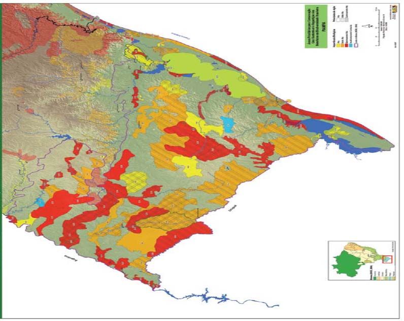
Hesperomeles. The grass páramo appears gradually as the effects of elevation and climate lessen the
shrubby growth-forms and the dominance of the tussock grasses (i.e. Festuca, Calamagrostis and
Stipa) is evident together with stem rosettes (e.g. Espeletia, Puya), small patches of upright shrubs of
the genera Diplostephium, Hypericum and Pentacalia (Ramsay and Oxley 1997), and patches of
monotypic or mixed forest of Polylepis, Gynoxis or Buddleja.

The super-páramo vegetation is primarily found in Ecuador and Colombia, on the slopes of the
highest mountains at 4100–4800 m altitude. This category can be divided in two altitudinal belts
(Sklenar 2000). The lower super-páramo has a closed vegetation of postrate shrubs (i.e. Loricaria,
Pentacalia), cushions (Plantago rigida, Xenophyllum spp., Azorella spp.), acaulescent rosettes
(Hypochaeris, Oritrophium), and tussock grasses (Calamagrostis, Festuca). The upper super-páramo
at 4400–4800 m lacks postrate shrubs and tussock grasses and plant cover is patchy. Recent
observations indicate that floristic composition of the super-páramo depends on site-specific water
availability, which in turn is highly correlated with precipitation pattern of each mountain area
(Sklenar & Lægaard 2003; Sklenar et al. 2008). Topographic variations at site scale result in azonal
habitats (cushion bogs, mires and aquatic vegetation) at perhumid areas, and even finer scale
differences within these habitats (Cleef 1981; Bosman et al. 1993).

This ecosystem plays a fundamental role in sustaining the livelihoods of millions of people,
providing essential ecosystem services such as water production for urban use, irrigation and
hydropower generation (Buytaert et al. 2006; Bradley et al. 2006). The generation and preservation
of these services strongly depend on the integrity of the ecosystem, which is expressed as a delicate
inter-dependency amongst three key elements: a) hydro-physical properties of the soil, b) vegetation
structure, and c) water cycle. The maintenance of these properties allows the existence of different
elements of this rich biodiversity aggregated at different spatial scales.

1.2 Impact of human settlement

Human activities in the páramo have increased drastically over the last two decades (Gondard 1988;
de Koning et al. 1998). The páramo is progressively more used for intensive cattle grazing,
afforestation with exotic species, cultivation and human inhabitance (Buytaert et al. 2006). There are
strong scientific evidences that these activities have a drastic impact on the integrity of the
ecosystem. Land use practices have a significant, negative effect on composition and structure of the
vegetation (Hofstede 1995; Ramsay and Oxley 1997; Suárez and Medina 2001), on their above-
below ground biomass ratio (Hofstede et al. 1995; Ramsay and Oxley 2001), on hydrological
behaviour of the system - in particular water production and regulation capacity - (Farley et al. 2004;
Buytaert et al. 2006, 2007), and on chemical/physical properties of the soils (Poulenard et al. 2001,
2004; Podwojewski et al. 2001).

1.3 Current status:

Natural state:
This is a very tricky question. Páramos have been described by various authors as a cultural
landscape, which means extensive human use has occurred there for centuries. It is very difficult to
define a boundary that allows differentiation between “natural” páramos from “transformed” ones.
Nevertheless, at least 60% of the “original” páramo extension remains (F. Cuesta com.pers.). This
figure includes the páramo that has been “used” for centuries. The question still to be answered is
how much of that 60% can be classified as really “natural”.
                                                                                                       4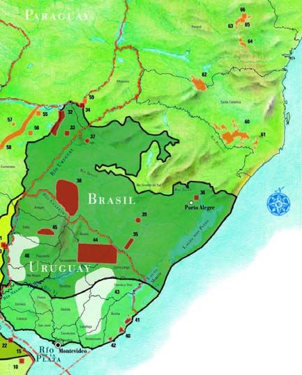
Formal Protection:

In total, 43,4% of páramo biome is formally protected. This protection is distributed as within the
different countries as shown in Table 1.

                              Table 1: Protected Areas within the Countries

                                                            Formally       Percent of
                                        Total páramo
                     Country                                protected      protection
                                         area (Ha)
                                                            area (Ha)         (%)
                    Colombia              1,405,765          621,768          44.2
                     Ecuador              1,835,834          719,262          39.2
                      Perú                  95,346            5,381            5.6
                    Venezuela              239,854           205,109          85.5
                      Total               3,576,798         1,551,520         43.4

1.4 Opportunities for improving the level of protection and conservation in the region

The opportunities are high due to the increasing awareness of the importance of páramo in the four
countries as water providers for the major Andean Cities and for irrigation. However, the creation of
protected areas (such as national parks) is not the only means for improving the level of protection
within the region. Conservation agreements at Municipalities and community scales to protect
specific páramo areas are much more feasible nowadays. For instance, Proyecto Páramo Andino, a
major UNEP-GEF initiative, is contributing to this purpose and identifying this local strategy as one
of the most effective ways to protect páramo areas. It needs to be mentioned that agreements of this
kind already taking place are not included in the official statistics of protected areas given above.

1.5 Suggested next steps and action plan

To define key areas for páramo protection based on a conservation planning framework.

                                                                                                      5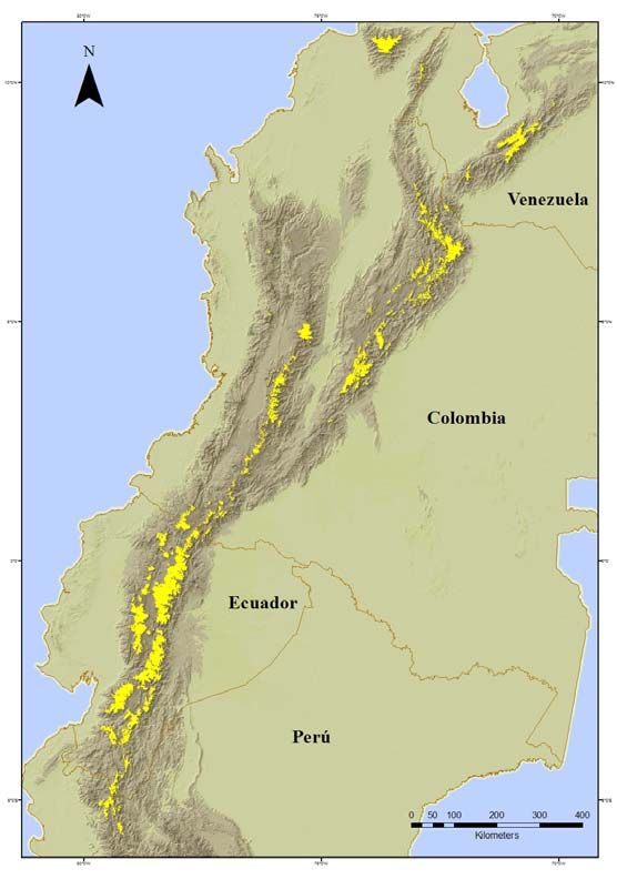
1.6 Appendices

         Map1. Important existing and proposed páramo areas are highlighted in yellow.

              Table 2. List of legally protected grassland areas in the region and size.
Extracted from: Cuesta F., K. Beltrán, B. De Bievre. In press. Los páramos de los Andes del Norte. Mecanismo de
                Información de Páramos. Proyecto Paramo Andino. CONDESAN, GEF-PNUMA.

                                                                            Area
                                                                         occupied by
                        Country               Protected Area               páramo
                                                                          ecosystem
                                                                             (ha)
                                       Antisana                                  62,810
                                       Cajas                                     28,722
                                       Cayambe Coca                             159,734
                         Ecuador       Chimborazo                                50,296
                                       Cotacachi Cayapas                         27,449
                                       Cotopaxi                                  32,011
                                       El Angel                                  15,371
                                                                                                                  6
El Boliche 41
ILinizas 30,030
LLanganates 93,788
Pasochoa 252
Podocarpus 23,964
Sangay 194,793
Chingaza 36,321
Complejo Volcanico Dona
Juana 6,144
Cordillera de los Picachos 3,709
El Cocuy 140,437
Galeras 2,642
Guanenta-Alto Rio Ponce 2,672
Iguaque 2,677
Isla de la Corota 3,045
Las Hermosas 62,702
Los Farallones de Cali 888
Los Nevados 49,503
Munchique 131
Nevado del Huila 40,549
Paramillo 953
Perija 34
Pisba 11,346
Colombia Purace 24,217
Serrania de los Yariguies 428
Serrania de Minas 103
Sierra Nevada de Santa
Marta 120,556
Sumapaz 106,350
Tama 4,303
Tatama 1,993
Dinira 3,150
El Tama 1,326
Juan Pablo Penialosa en
los Paramos Batallon y la
Negra 14,113
Perija 10,859
Venezuela
Sierra La Culata 88,553
Sierra Nevada 73,308
Tama 103
Teta de Niquitao-Guirigay
(Sector A) 7,397
Teta de Niquitao-Guirigay
(Sector B) 6,369
Perú Tabaconas Namballe 5,381
TOTAL 1,551,523
7Table 3. Type of páramo ecosystem, size, protected surface and percent of protection.
Extracted from: Cuesta F., K. Beltrán, B. De Bievre. In press. Los páramos de los Andes del Norte. Mecanismo de
Información de Páramos. Proyecto Paramo Andino. CONDESAN, GEF-PNUMA.
Total Surface
Ecosystem
Ecosystem type area of within
protection
(páramo) ecosystem Protected
(%)
type (Ha) Area (Ha)
Arbustales Bajos y Matorrales
Altoandinos Paramunos 170,660 46,097 27.0
Arbustales y Frailejonales Altimontanos
Paramunos 1,394,549 685,324 49.1
Bofedales Altimontanos Paramunos 333,800 187,730 56.2
Bofedales Altoandinos Paramunos 14,836 3,419 23.0
Bosque de Polylepis Altimontano
Pluvial de los Andes del Norte 1,144 1,115 97.4
Nieve/Glaciares 23,073 22,421 97.2
Pajonales Altimontanos y Montanos
Paramunos 1,277,754 435,469 34.1
Pajonales Arbustivos Altimontanos
Paramunos 199,920 41,561 20.8
Pajonales Edafoxerófilos Altimontanos
Paramunos 74,125 30,400 41.0
Vegetación Geliturbada y Edafoxerófila
Subnival Paramuna 98,552 93,392 94.8
Vegetación Palustre y Acuática
Altoandina Paramuna 12,766 4,592 36.0
TOTAL 3,601,179 1,551,520 43.08
References
Acosta-Solis, M. 1985. El Arenal del Chimborazo, ejemplo de puna en el Ecuador. Revista
Geográfica 22: 115–122.
Acosta-Solis, M. 1986. Los páramos del Ecuador. Cultura: revista del Banco Central del Ecuador
8(24a). Pp 221-220. Quito.
Bosman, A.F., P. C. van der Molen, R. Young, and A. M. Cleef. 1993. Ecology of a páramo cushion
mire. Journal of Vegetation Science 4: 633–640.
Bradley, R. S., M. Vuille, H. F. Diaz, W. Vergara. 2006. Threats to water supplies in the tropical
Andes. Science 312: 1755–1756.
Buytaert, W., R. Celleri, B. De Bièvre, R. Hofstede, F. Cisneros, G. Wyseure, and J. Deckers. 2006.
Human impact on the hydrology of the Andean páramos. Earth-Science Reviews 79: 53–72.
Buytaert, W., V. Iñiguez, and B. De Bièvre. 2007. The effects of afforestation and cultivation on
water yield in the Andean páramo. Forest Ecology and Management xx: xxx-xxx.
8Cleef, A.M. 1981. The vegetation of the Páramos of the Colombian Cordillera Oriental.
Dissertationes Botanicae 61. J. Cramer, Vaduz.
Cuatrecasas 1979. Growth forms of the Espeletiinae and their correlation to vegetation types of the
high tropical Andes. pages. Pp. 397–410. In: Larsen, K. & Holm-Nielsen, L. B. (eds), Tropical
Botany. Academic Press, New York.
Cuatrecasas, J. 1968. Páramo vegetation and its life forms. Colloquium Geographicum 9: 163–186.
De Koning, A. Veldkamp, L. O. Fresco. 1998. Land use in Ecuador: a statistical analysis at different
aggregation levels. Agriculture, Ecosystems and Environment 70: 231-247
Fjeldså, J. (1992) Biogeography of the birds of the Polylepis woodlands of the Andes. Páramo: an
Andean ecosystem under human influence (ed. By H. Balslev and J.L. Luteyn), pp. 31–44. Academic
Press, London.
Gondard P. 1988. Land use in the Andean region of Ecuador: from inventory to analysis. Land Use
Policy 5: 341–348.
Farley K. A., E. F. Kelly, and R. G. M. Hofstede. 2004. Soil organic carbon and water retention after
conversion of grasslands to pine plantations in the Ecuadorian Andes. Ecosystems 7: 729–739.
Harling, G. 1979. The vegetation types of Ecuador – a brief survey. Pp. 165–174. In: Larsen, K. &
Holm-Nielsen, L. B. (eds), Tropical Botany. Academic Press, New York.
Hedberg, O. 1964. Features of Afroalpine Plant Ecology.Acta Phytogeographic Suecica 49.
Hofstede, R., Segarra, P., Mena, P. V., 2003. Los Páramos del Mundo. Global Peatland Initiative/NC-
IUCN/EcoCiencia, Quito.
Hofstede R.G.M. 1995. Effects of Burning and Grazing on a Colombian Páramo Ecosystem. Ph.D.
thesis, University of Amsterdam, Amsterdam.
Hofstede R.G.M., E.J. Chilito and E.M. Sandoval. 1995. Vegetative structure, microclimate, and leaf
growth of a páramo tussock grass species, in undisturbed, burned and grazed conditions. Vegetatio
119: 53-65.
Jørgensen, P.M. and C. U. Ulloa. 1994. Seed plants of the high Andes of Ecuador — a checklist.
AAU Reports 34, 1–443.
Josse C., Cuesta F., Navarro G., Barrena V., Cabrera E., Chacón-Moreno E., Ferreira W., Peralvo M.,
Saito J. y Tovar A. 2008. Ecosistemas de los Andes del Norte y Centrales. Bolivia, Colombia,
Ecuador, Peru y Venezuela. CAN, Programa Regional ECOBONA, CONDESAN-Proyecto Páramo
Andino, Programa BioAndes, EcoCiencia, NatureServe, LTA-UNALM, IAvH, ICAE-ULA, CDC-
UNALM, RUMBOL SRL. Lima.
9Lægaard, S. 1992. Influence of fire in the grass páramo vegetation of Ecuador. Páramo: an Andean
ecosystem under human influence (ed. by H. Balslev and J.L. Luteyn), pp. 151–170. Academic Press,
London.
Luteyn, J. L., 1992. Páramos: why study them? In: Balslev, H., Luteyn, J. L. (Eds.), Páramo: an
Andean ecosystem under human influence. Academic Press London, pp. 1-14.
Luteyn, J.L. 1999. Páramos: A Checklist of Plant Diversity, Geographical Distribution, and Botanical
Literature. The New York Botanical Garden Press, New York.
Myers, N., Mittermeier, R. A., Mittermeier, C. G., da Fonseca, G. A. B., Kent, J., 2000. Biodiversity
hotspots for
Podwojewski P., J. Poulenard, T. Zambrano, R. Hofstede. 2002. Overgrazing effects on vegetation
cover and properties of volcanic ash soil in the páramo of Llangahua and La Esperanza (Tungurahua,
Ecuador). Soil Use and Management 18: 45–55.
Poulenard J, Podwojewski P, Janeau JL, Collinet J. 2001. Runoff and soil erosion under rainfall
simulation of andisols from the Ecuadorian páramo: effect of tillage and burning. Catena 45: 185–
207.
Poulenard, J., Michel, J.C., Bartoli, F., Portal, M., Podwojewski, P., 2004. Water repellency of
volcanic ash soils from Ecuadorian páramo: effect of water content and characteristics of
hydrophobic organic matter. European Journal of Soil Science 55, 487–496.
Ramsay P.M. 1992. The Páramo Vegetation of Ecuador: The Community Ecology Dynamics and
Productivity of Tropical Grasslands in the Andes. Ph.D. thesis, University of Wales, Bangor.
Ramsay P. M. and E.R.B. Oxley. 1997. The growth form composition of plant communities in the
Ecuadorian páramos. Plant Ecology 131: 173 –192.
Sklenář P., and P. M. Ramsay. 2001. Diversity of páramo plant communities in Ecuador. Diversity
and Distribution 7: 113 –124.
Sklenář P and H. Balslev H 2005. Superpáramo plant species diversity and phytogeography in
Ecuador. Flora 200: 416 –433.
Sklenář, P., and S. Lægaard. 2003. Rain-shadow in the high Andes of Ecuador evidenced by pa´ ramo
vegetation. Arctic Antarctic and Alpine Research, 35, 8–17.
Sklenar, P., J. Bendix, and H. Balslev. 2008. Cloud frequency correlates to plant species composition
in the high Andes of Ecuador. Basic and Applied Ecology xx: xx-xx.
Simpson, B.B. (1974). Glacial migrations of plants: Island biogeographical evidence. Science, 185,
698–700.
Suárez E., and G. Medina. 2001. Vegetation Structure and Soil Properties in Ecuadorian Páramo
Grasslands with Different Histories of Burning and Grazing. Arctic, Antarctic, and Alpine Research
33: 158-164.
10Vuilleumier, F. & Monasterio, M. (1986) High altitude tropical biogeography. Oxford University
Press, Oxford.
Smith, A. P. 1994. Introduction to tropical alpine vegetation. Pp. 1–19. In: Rundel, P. W., Smith, A.
P. & Meinzer, F. C. (eds), Tropical Alpine Environments: Plant Form and Function. Cambridge
University Press, Cambridge.
Smith, A. P. & Young, T. P. 1987. Tropical alpine plant ecology. Ann. Rev. Ecol. Syst. 18: 137–158.
112 Central Andean Grasslands (Páramo, Puna) and High-Andean (central and southern Perú,
western Bolivia, northern Chile and northwestern Argentina).
Authors: Stephan Halloy1, Stephan G. Beck2, Juan Carlos Ledezma1
(1) Conservación Internacional Bolivia. Calacoto, Calle 13, Nº 8008. La Paz - Bolivia
s.halloy@conservation.org; j.ledezma@conservation.org
(2) Instituto Ecología Bolivia. lpb.dir@acelerate.com
Presentation in Hohhot: Andrea V. Michelson3 & Robert Hofstede3
(3) UICN Sur. Calle Quiteño Libre E12-15 y la Cumbre. Quito, Ecuador. andrea.michelson@sur.iucn.org
2.1 Major indigenous grassland types
Introduction. Here we describe the Central Andean Grasslands, understood in a broad way as open
vegetation, mostly dominated by grasses, herbs and sometimes shrubs, without, or with sparse, tree
cover, in the high Andes, mostly above 3000 m. The geographic delimitation is to some degree
arbitrary and practical. The northern Andean grasslands of the páramos are treated in a separate
chapter (Venezuela, Colombia, Ecuador, northern Peru). For the Central Andes we include here a
variety of physiognomic and floristic types south of the northern páramos and extending along the
Andes through central and southern Perú, western Bolivia, northern Chile and northwestern
Argentina.
Origin and nature of grasslands discussed. As the purpose of this work is to identify conservation
priorities, it must include a discussion about the origin and nature of these ‘grasslands’, an issue still
hotly debated and far from definitely resolved. In summary, the debate relates to whether these
grasslands are ‘natural’ (i.e. original, pre-human), or anthropically determined. What does emerge
from this debate is that there is no single answer, either for the whole region, or for one of its
vegetation types. Rather there will be particular answers for particular areas. Some areas now in
grasslands were previously woodlands. Through fire and grazing, they have become grasslands.
Conservation of these areas must therefore consider the human history of use, and define priorities
based on landscape values, flora and fauna, endemism and unique representativeness.
Classification and percentage protected. There are many ways to classify the ‘grasslands’ within the
geographic region defined above. In such a short treatment we can only superficially deal with the
huge real heterogeneity, without doing justice to the abundant literature and expert opinions on the
subject. In addition, whatever classification is used, mapping these categories has not been done for
the whole region at a reasonable scale. Here we have therefore had to make some rough educated
guesses about the equivalence of ground based classifications (such as those based on floristic and
physiognomic elements described below) with satellite based large scale mapping exercises such as
those of (Eva et al., 2002). One of us (Juan Carlos Ledezma) superimposed the Eva et al. (2002)
classification with the IUCN protected areas shapefiles for South America to arrive at the
percentages of each category under some form of protection.
General grassland types. The Central Andean grasslands are classified into types by physiognomy,
floristics and bioclimates. Within the area defined, moister, denser grasslands on the eastern fringes
of the Andes are called páramos, páramo yungueño or Andean pastures (pastizal andino). These
are a southern extension of the northern Andean páramos, floristically and physiognomically related,
extending from the northern páramos, through Perú, Bolivia and northwestern Argentina south to the
mountains of Córdoba province.
12To the west and in rainshadow areas, páramos are replaced by progressively drier vegetation types
broadly encompassed in the term Puna. The term puna encompasses diverse ecosystems of the high
Central Andes above 3400 m from northern Peru to northern Argentine. Troll (Beck, 1985; Ruthsatz,
1983; Troll, 1959; Troll, 1968) distinguished between moist puna, dry puna, thorn puna and desert
puna. The term covers high dense grassland with some shrubs in the moist puna and transition to the
páramo yungueño, open grassland, cushion vegetation (Azorella, Pycnophyllum) and tolares
(evergreen resinous shrublands of Baccharis and Parastrephia) in the dry puna and thorn puna. The
desert puna is dominated by the huge salt lakes with scattered halophytes around and in the
depressions. The thorn puna may be included as a type of desert puna in the SW. New terms and
delimitations for the puna of Bolivia were recently proposed by (Ibisch et al., 2003; Navarro, 2002).
The highest reaches above puna and páramo (mostly above 4200 m depending on areas) belong to a
phytogeographically distinct unit called the High-Andean (altoandino) region (e.g. (Cabrera, 1976;
Cabrera and Willink, 1973). Here grasses become sparser but cushions and cryptofruticetum become
dominant, with a larger number of endemic species (Halloy, 1985).
Each one of these broad types can be subdivided into distinct categories, some or which are briefly
discussed below.
I) Páramo
The páramo yungueño is found on the Eastern fringe of the Andes, above present day treeline, and
conditioned by extremely moist and cloudy conditions (perhumid). It extends from northern Perú to
central Argentina (Beck, 1998; Halloy, 1997; Rangel Ch., 2004; Troll, 1959)
The vegetation is a tall tussock grassland with Cortaderia, Deyeuxia (sometimes included in
Calamagrostis), Festuca and Poa, “chusqueales” with bamboos of the genus Chusquea, undescribed
species of Neurolepis rare herbaceous gramineae such as Aphanelytrum procumbens and Hierochloe
redolens. Between the grasses are prostrate shrubs such as Miconia chionophylla, herbs such as
Arcytophyllum, Oritrophium, Laedstadia, Jamesonia ferns and occasionally the short arborescent
fern Blechnum loxense (or related species). There are also shrubs and subshrubs of the compositae
Baccharis, Gynoxys, Loricaria, Senecio (s.l.), and also Buddleja montana, Escallonia myrtilloides
and Hypericum laricifolium. Overgrazed areas become short pastures.
Ever-wet climatic conditions are unfavorable to stock, and the human population is low. There are
however ancient Inca and pre-Inca roads, terraces and houses. Mining in colonial times also
increased penetration. Occasional burns in exceptionally dry years (Laegaard, 1992) seem to
maintain this ecosystem. Stock raising is still dispersed nonetheless, and mining as well as extraction
of firewood and canes is still performed.
The distribution of these páramos is naturally fragmented by topography and climate. Their total area
is reduced. Being located in a transition between low and high areas, dry and wet, they are probably
highly vulnerable to climate change and desiccation. They are also increasingly fragmented by roads,
deforestation, mining and other activities.
II) Puna
The puna is dominated by grasses (Deyeuxia, Festuca, Poa) with prevalence in the dryer areas of
Festuca orthophylla and several species of Stipa. Low herbaceous grasses of Muhlenbergia and
Distichlis humilis together with halophytic shrubs cover the extended salt plains. Local fresh water
13cushion peat bogs or fens (bofedales or ciénagas) are dominated by vascular plants in the Juncaceae,
Cyperaceae, and Asteraceae (García and Beck, 2006).
The aquatic flora of the numerous lakes is diverse with a few endemic species; playing an important
role for human use (boats, handicrafts) and cattle fodder. Few trees besides Polylepis and Buddleja
grow nowadays in the Puna.
Human habitation is widespread in the puna, tending to increase toward the moister eastern areas.
Large areas of the central puna are cultivated with native tubers and grains. Practically all of the puna
is grazed in some form or other by sheep, alpaca and llamas, with cattle, horses, donkeys and pigs in
localized moister areas. Grazing is typically migratory, with extensive grasslands/shrublands used
during moister parts of the year and stock concentrated in the ciénagas/bofedales in the drier part of
the year. Grazing is accompanied by fire as a management tool.
In spite of altitude and extreme climatic conditions the Puna is home to about 1500 plant species
with about 40 endemic genera. Most of the genera known from the Parámo and Jalca are also found
in the Puna.
As described above, the puna covers an area of more than 10 degrees latitude and up to 300 km wide
with a large diversity of subtypes. The following physiognomic types can be distinguished, in
addition to the climatic types distinguished by Troll:
- Praires or pastures, dominated by grasses and other herbs
- Tolares or resinous shrublands, dominated by evergreen resinous shrubs (Baccharis and
Parastrephia, also Chersodoma and other genera)
- Bosquecillos de Polylepis or open Polylepis woodlands (these woodlands raise the issue
mentioned above of what the original vegetation was, e.g. (Ellenberg, 1966; Kessler and
Driesch, 1993)
- Salt soils and salt flats in the central and southern endorheic basins with halophytes
- Ciénagas, bofedales, fresh water peat bogs or fens (Ruthsatz, 1993; Ruthsatz, 1995; Ruthsatz,
2000)
- Aquatic vegetation
The latter two, although of small extension, are a conservation priority. They concentrate high levels
of biodiversity, endemism, provide pasture for stock, and are critical for water regulation and
availability. They have also shown clear signs of vulnerability to climate change and to poor
management practices (Alzérreca A. et al., 2003; Flores Cartagena, 2002; Yager et al., 2007).
Many puna areas are modified, to different degrees, depending on proximity of human settlement.
Extensive grazing (with the adjunct of fire) is most widespread and threatens pastures, shrublands
and woodlands, as well as being concentrated in ciénagas and at the edges of wetlands in the dry
season. More locally, puna areas are affected by mining and mine tailings, by agriculture, and by
urban development and waste disposal. However, the millennial development of agriculture in the
northern moist puna has become part of the hybrid or comensal human-nature landscape, with large
areas developed over centuries into terraced hills. This landscape itself, with its attendant sustainable
agricultural methods, is worthy of preservation (Halloy et al., 2005).
III) High Andean
Above the puna region, between around 4200 or 4500 m and the highest limit of vegetation, grows a
sparse vegetation dominated by a few grasses (Deyeuxia, Poa, and endemics such as Anthochloa
lepidula, Dielsiochloa floribunda, Dissanthelium calycinum, D. trollii and D. macusaniense (Beck,
1998; Renvoize, 1998) and a large number of cushion, plaque, rosette and dwarf shrubs (Azorella,
Pycnophyllum, Nototriche, Werneria, Xenophyllum).
14At lower altitudes (4400- 4800 m), denser grass swards develop with Deyeuxia (Deyeuxia minima),
Agrostis, Poa and Stipa. Within the graminoid mosaic there are also Luzula racemosa and
Gentianella (Beck, 1988) and cyperaceae of the genus Trichophorum and the endemic Oreobolopsis
tepalifera, together with mostly perennial herbs. Most common families include Asteraceae,
Caryophyllaceae, Geraniaceae, and Malvaceae (Gonzales Rocabado, 1997).
Peat bogs and lakes also form large wetlands in the high Andean. These are critical areas, although
small, for their inordinately large diversity, concentration of bird fauna, and water regulation for
lower regions.
Being more remote, and mostly above the limits of human habitation, the high-andean has only
sparse grazing impacts. However it has suffered from targeted harvesting of particular species of
animals and plants (particularly medicinal plants and firewood). And given slow regeneration rates
due to cold temperatures and low atmospheric pressure, combined with the insular nature of the high
altitude sites, small populations of restricted endemics are threatened. Climate change has already
meant a rise in the limits of cultivated plants into this region and a rise in the range of grazing
camelids (Seimon et al., 2007a; Seimon et al., 2007b).
2.2 Impact of human settlement
The landscape has been modified in the past and is changing under man's action as shown by the pre-
Hispanic settlements, terraces and the present intensive farming activities (Ellenberg, 1979). A lot of
the humid puna has been converted in farming ground, the steeper areas and the fallow land are used
for grazing by cattle, sheep, lama and alpaca, in the southern more arid areas only lama survive under
hard environment conditions. Recently more areas of the dry puna in the south of Oruro are
converted in mechanized quinua cultivation.
Numerous edible tubercles of Solanum, Oxalis, Ullucus and Tropaeolum are originated in the Puna,
beside the pseudo cereals Chenopodium quinoa (quinua) and Ch. pallidicaule (cañahua) and many
medicinal plants known by the Aymara and Quechua.
Stock grazing and attendant fire management is one of the main threats in the three broad grassland
types described. This is clearly more obvious in the drier areas, where desertification has progressed
over wide areas (dry puna, shrubland, and in bofedales)(Alzérreca A. et al., 2003).
2.3 Current status:
Conservation efforts are still poor and locally concentrated in a few protected areas. Percentage of
surface included in Protected Areas when considering the whole Puna ecoregion is minimum (Fig.1
and Table 1).
15Table 1. Percent of indigenous vegetation formally protected for the whole puna ecoregion,
according to Eva et al. (2002). (See map references for vegetation type specifications)
Surface
Total Area of Ecosystem
within
Ecosystem type Ecosystem type protection
Protected
(km2) (%)
Area (km2)
Moorlands / heathlands 2.748 620 22,55
Closed montane grasslands 102.141 4.814 4,71
Open montane grasslands 120.278 6.053 5,03
Closed steppe grasslands 11.333 1.759 15,52
Open steppe grasslands 84.808 4.746 5,60
Sparse desertic steppe shrub
/grasslands 191.622 12.532 6,54
Barren / bare soil 277.927 32.851 11,82
Desert 174.296 2.663 1,53
Closed shrublands 267.184 27.536 10,31
Open shrublands 122.800 8.826 7,19
TOTAL 1.355.135 102.401 8%
2.4 Opportunities for improving the level of protection and conservation in the region
Apparently in a few areas migration of people to the urban centers reduced pressure, but mostly
overgrazing and agricultural goes on. All activities must be coordinated with the local people, who
are getting more interested if they find other opportunities of income.
2.5 Constraints against improving the level of protection and conservation in the region
Growing population, opening of new roads, mining activities.
2.6 Suggested next steps and action plan
Uniform inventory and mapping activities in the 4 countries, select areas with good conservation
status and concentration of endemics and vulnerable species.
162.7 Appendices
Map 1. Protected areas of whole Puna ecoregion (adapted from Eva et al. 2002)
Vegetation types definitions:
Moorlands / heathlands: Ciénagas, bofedales, fresh water peat bogs or fens (to small to see in the map)
Closed montane grasslands: Paramos, partially
Open montane grasslands: Interandean valleys, mostly, little grassland
Closed steppe grasslands: Moist Puna
Open steppe grasslands: Moist Puna, partially
Sparse desertic steppe shrub /grasslands: Altoandino, rocky dry puna with thorn shrubs, partially
Barren / bare soil: Dry and desertic Puna
Desert: Only a reduced surface may be included
Closed shrublands: different areas, some prepuna and interandean valleys, also Polylepis woodlands
Open shrublands: NO PUNA, dry forest?
MISSING SURFACE: Mosaic agriculture/degraded vegetation: Moist Puna, partially, sometimes converted to
agriculture
17Table 2. List of legally protected grassland areas in the region, by both grassland type and size.
Country Protected Area Area (km2)
Argentina Baritú 1866
Calilegua 763
Campo de los Alisos 7257
Copo 2081
El Leoncito 600
El Rey 446
Iberá 1250
Iguazú 493
Ischigualasto 532
Laguna Brava 3811
Laguna de los Pozuelos 1131
Laguna de los Pozuelos BioRes (National) 831
Los Andes 2539
Los Cardones 655
Olaroz-Caucharí 2202
Río Pilcomayo 513
San Guillermo 8074
Talampaya 1925
Urugua-í 878
Valle Fértil 7382
Bolivia Aguarague 1091
Amboró 12651
Apolobamba 4745
Carrasco 6964
Cavernas del Repechón 212
Cordillera de Sama 1054
Cotapata 617
Eduardo Avaroa 6854
El Palmar 606
Estación Biológica del Beni 1352
Iñao 2646
Isiboro Sécure 1026
Kaa-Iya Del Gran Chaco 6347
Madidi 9289
18Manuripi 7567
Noel Kempff Mercado 1612
Otuquis 10352
Pilón Lajas 4012
Sajama 1005
San Matías 2993
Tariquia 2482
Toro Toro 1683
Tunari 3292
Chile Bosque de Fray Jorge 8989
La Chimba 3303
La Portada 26
Las Chinchillas 4281
Las Vicuñas 2081
Lauca 1404
Llanos de Challe 458
Llullaillaco 3796
Los Flamencos 738
Nevado de Tres Cruces 1701
Pampa del Tamarugal 996
Pan de Azúcar 3177
Pichasca 117
Pingüino de Humboldt 330
Rapa Nui (or Easter Island) 1653
Salar de Surire 1742
Volcán Isluga 1676
Peru A.B. Canal Nuevo Imperial 18
Algarrobal El Moro 308
Allpahuayo Mishana 584
Alto Mayo 2092
Alto Purús 2510
Amarakaeri 4023
Ampay 3865
Ashaninka 1856
Aymara Lupaca 3207
Bahuaja Sonene 2329
Bosque de Pomac 6097
Calipuy 5256
19Cerros de Amotape 985
Chacamarca 2462
Chancaybaños 2854
Cordillera Azul 1372
Cordillera de Colan 656
Cordillera Huayhuash 688
Cutervo 2572
El Angolo 681
El Sira 6219
Gueppi 6203
Huascarán 3467
Huayllay 6869
Junín 533
Lachay 5226
Lagunas de Mejía 720
Laquipampa 9502
Machiguenga 2199
Machu Picchu 374
Manglares de Tumbes 3100
Manu 1696
Megantoni 2161
Nor Yauyos-Cochas 2243
Otishi 3077
Pacaya Samiria 2192
Pagaibamba 2084
Pampa de Ayacucho 302
Pampa Galeras Barbara D' Achille 8074
Pampa Hermosa 9694
Pantanos de Villa 268
Paracas 3407
Pucacuro 6458
Pui Pui 540
Puquio Santa Rosa 307
Purús 2020
Río Abiseo 2776
Río Rímac 538
Salinas y Aguada Blanca 3688
San Matias San Carlos 1506
20Santiago Comaina 1682
Sub Cuenca del Cotahuasi 4919
Sunchubamba 625
Tabaconas Namballe 348
Tambopata 2776
Tingo María 4847
Titicaca 9951
Tumbes 819
Yanachaga-Chemillen 1118
Llaneza 3199
TOTAL 344,291
References
Alzérreca A., H., Luna Ch., D., Prieto C., G. and Céspedes E., J., 2003. Estudio de la Capacidad de
Carga en Bofedales para la Cría de Alpacas en el Sistema Titicaca, Desaguadero, Poopó y Salar de
Coipasa (T.D.P.S.), Asociación Integral de Ganaderos en Camélidos de los Andes Altos
(AIGACAA), La Paz. 290 pp.
Beck, S.G., 1985. Florula ecológica de Bolivia: Puna semiárida en el Altiplano Boliviano. Ecología
en Bolivia, 6: 1-41.
Beck, S.G., 1988. Las regiones ecológicas y las unidades fitogeográficas de Bolivia. In: C. de
Morales (Editor), Manual de Ecología. Instituto de Ecología, Universidad Mayor de San Andrés, La
Paz, pp. 233-271.
Beck, S.G., 1998. Ecología y fitogeografía de las gramíneas de Bolivia. In: S.A. Renvoize (Editor),
Gramíneas de Bolivia. Royal Botanic Garden, Kew, pp. 1-10.
Cabrera, A.L., 1976. Regiones Fitogeográficas Argentinas. Enciclopedia Argentina de Agricultura y
Jardinería, Vol II, Fascículo 1, segunda edición. ACME, Buenos Aires, 85 pp.
Cabrera, Á.L. and Willink, A., 1973. Biogeografía de America Latina. OEA, Washington, D.C.
Ellenberg, H., 1966. Leben und Kampf an den Baumgrenzen der Erde (Vida y lucha en los limites de
crecimiento arbóreo de la tierra). Naturwiss. Rundschau, 19: 133-139.
Ellenberg, H., 1979. Man’s influence on tropical mountain ecosystems in South America. The
second Tansley Lecture. Journal of Ecology, 67: 401-416.
Eva, H.D. et al., 2002. A Vegetation Map of South America. European Commission Joint Research
Center, Luxembourg, 48 pp.
García, E. and Beck, S.G., 2006. Punas. In: M. Moraes R., B. Øllgaard, L.P. Kvist, F. Borchsenius
and H. Balslev (Editors), Botánica Económica de los Andes Centrales. Universidad Mayor de San
Andrés, Plural Editores, La Paz, pp. 51-76.
21Gonzales Rocabado, M.J., 1997. Comunidades vegetales de morenas pleistocénicas y holocénicas de
los nevados Huayna Potosí, Mururata e Illimani (Cordillera Real, La Paz, Bolivia), Universidad
Mayor de San Andrés, La Paz, 159 pp.
Halloy, S.R.P., 1985. Climatología y Edafología de Alta Montaña en Relación con la Composición y
Adaptación de las Comunidades Bióticas (con especial referencia a las Cumbres Calchaquíes,
Tucumán), #85-02967. University Microfilms International publ.(UMI), Ann Arbor, Michigan, 839
pp.
Halloy, S.R.P., 1997. Anconquija Region, North-western Argentina. In: S.D. Davis, V.H. Heywood,
O. Herrera-MacBryde, J. Villa-Lobos and A.C. Hamilton (Editors), Centres of Plant Diversity - A
guide and strategy for their conservation. WWF, IUCN, Cambridge, UK., pp. 478-485.
Halloy, S.R.P., Seimon, A., Yager, K. and Tupayachi Herrera, A., 2005. Multidimensional (climate,
biodiversity, socio-economics, agriculture) context of changes in land use in the Vilcanota
watershed, Peru. In: E.M. Spehn, M. Liberman Cruz and C. Körner (Editors), Land Use Changes and
Mountain Biodiversity, 2005. CRC Press LLC, Boca Raton FL, USA, pp. 323-337.
Ibisch, P.L., Beck, S.G., Gerkmann, B. and Carretero, A., 2003. Ecoregiones y ecosistemas. In: P.L.
Ibisch and G. Mérida (Editors), Biodiversidad: La riqueza de Bolivia, Estado de conocimiento y
conservación. Ministerio de Desarrollo Sostenible. Edit. FAN, Santa Cruz de la Sierra, Bolivia.
Kessler, M. and Driesch, P., 1993. Causas e historia de la destrucción de bosques altoandinos en
Bolivia. Ecología en Bolivia, 21: 1-18.
Laegaard, S., 1992. Influence of fire in the grass paramo vegetation of Ecuador. In: H. Balslev and J.
Luteyn (Editors), Páramo - an Andean Ecosystem Under Human Influence. Academic Press,
London, pp. 151-170.
Navarro, G., 2002. Vegetación y unidades biogeográficas de Bolivia. In: G. Navarro and M.
Maldonado (Editors), Geografía Ecológica de Bolivia. Vegetación y Ambientes Acuáticos.
Fundación Simón I. Patiño, Cochabamba, pp. 1-500.
Rangel Ch., J.O., 2004. Patrones de riqueza y diversidad en la flora paramuna. Boletín de la
Sociedad Argentina de Botánica, 39: 307-314.
Renvoize, S.A., 1998. Gramíneas de Bolivia. Royal Botanic Gardens, Kew.
Ruthsatz, B., 1983. Der Einfluss des Menschen auf die Vegetation semiarider bis arider tropischer
Hochgebirge am Beispiel der Hochanden. Berichte Deutschen Botanischen Gesellschaft, 96: 533-
576.
Ruthsatz, B., 1993. Flora und ökologische Bedingungen hochandiner Moore Chiles zwischen 18000’
(Arica) and 400 30’ (Osorno) suedl. Phytocoenologia, 23: 157-199.
Ruthsatz, B., 1995. Vegetation und Ókologie tropischer Hochgebirgsmoore in den Anden
Nordchiles. Phytocoenologia, 25: 185-234.
22Ruthsatz, B., 2000. Die Hartpolster-Moore der Hochanden und ihre Artendiversitaet. Berichte der R.
Tuexen-Gesellschaft (RTG), 12: 351-371.
Seimon, A., Halloy, S.R.P. and Seimon, T.A., 2007a. Global High-altitude Limits for Aquatic
Vascular Plants. Arctic, Antarctic, and Alpine Research, 39: 340-341.
Seimon, T.A. et al., 2007b. Upward range extension of Andean anurans and chytridiomycosis to
extreme elevations in response to tropical deglaciation. Global Change Biology, 13: 288-299.
Troll, C., 1959. Die Tropischen Gebirge, ihre dreidimensionale klimatische und pflanzen-
geographische Zonierung. Bonner geogr. Abhandlungen, Bonn, 25: 1-93.
Troll, C. (Editor), 1968. Geo-ecología de las regiones montañosas de las Américas tropicales.
Proceedings of the UNESCO Mexico Symposium (Aug 1-3, 1966); Colloquium Geographicum 9: 1-
223. Ferd. Dümmlers Verlag, Bonn.
233 Río de la Plata Grasslands or Pampas & Campos (Argentina, Uruguay and Brazil).
Authors: Fernando Miñarro1, Ulises Martinez1, David Bilenca2, Fernando Olmos3.
(1) Fundación Vida Silvestre Argentina, Defensa 251, 6º K, (C1065AAC), Ciudad Autónoma de Buenos Aires,
Argentina. fernando.minarro@vidasilvestre.org.ar ; agrisust@vidasilvestre.org.ar
(2) Departamento de Ecología, Genética y Evolución; Facultad de Ciencias Exactas y Naturales, Universidad de
Buenos Aires. dbilenca@ege.fcen.uba.ar
(3) Instituto Nacional de Investigación Agropecuaria (INIA). Tacuarembó, Uruguay. Ecofisiología de Pasturas.
folmos@tb.inia.org.uy
Other contributors: Joaquín Aldabe4
(4) Aves Uruguay - BirdLife International. joaquin@aldabe.org
Presentation in Hohhot: Andrea V. Michelson5 & Robert Hofstede5
(5) UICN Sur. Calle Quiteño Libre E12-15 y la Cumbre. Quito, Ecuador. andrea.michelson@sur.iucn.org
3.1 Major indigenous temperate grassland types
The Rio de la Plata grasslands are the largest complexes of temperate grasslands ecosystems in South
America, comprising an area of approximately 750,000 km2 (Soriano et al. 1992). These grasslands
include the Pampas ecoregion of Argentina (540,000 km2) and the Campos ecoregion of Uruguay,
northeastern Argentina and southern Brazil (Miñarro and Bilenca 2008).
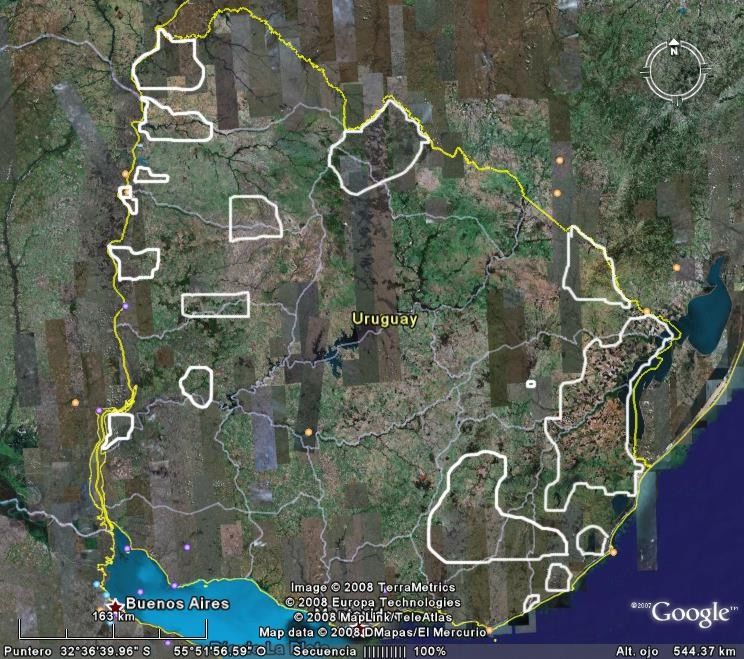
Most of the Río de la Plata grasslands occur over a vast plain, the Pampas, formed by thick
Quaternary loess deposits that have experienced varying degrees of local reworking. Exceptions to
this general pattern are most of the Uruguayan and Brazilian portions of the region, where a diverse
array of rocks such as Precambrian granite, Carboniferous sandstone, and Jurassic basalt is exposed
to surface and soil-forming processes (Paruelo et al 2007).
Pampas and Campos have a conspicuous and unique biodiversity, with thousands species of vascular
plants, including more than 550 different grass species. Mesothermic grasses prevail in this region of
mild climate (mean annual temperature of 10 to 20◦C) and a mean annual rainfall between 400 and
1600 mm (Soriano et al. 1992). Pampas grasslands were formerly dominated by tussock grasses that
covered most of the ground. Dominants comprise several warm-season (C4) and cool-season (C3)
grasses in approximately similar proportion. The most common genera among the grasses are Stipa,
Piptochaetium, Paspalum and Bothriochloa. Shrubs are little represented, but in some places,
probably as a result of disturbance, one of several species of Baccharis and Eupatorium may become
locally dominant (Paruelo et al. 2007).
Campos grasslands are dominated by grasses of the genera Andropogon, Aristida, Briza, Erianthus,
Piptochaetium, Poa, Stipa, Paspalum, Axonpus and Panicum (León 1991). Species composition in
Northern Campos is even more enriched in subtropical species (Andropogon) (Paruelo et al. 2007).
There are about 450-500 bird species -60 of them are strict grassland dwellers- and nearly 100
species of mammals (Bilenca and Miñarro 2004).
The community of grassland birds that make use of the southern cone grassland biome is really
diverse and abundant. There are several threatened species, and the main reason of this decline is
habitat loss. Perhaps the most emblematic species is the Eskimo Curlew (Numenius borealis), which
is probably extinct, owed to habitat loss and sport hunting during late 1800s. Other species are
endemic to southern cone grassland, and deserve special attention. It is important to note that among
24bird grassland dwellers, several grassland shorebirds that migrate from the arctic to the southern cone
have suffered important global declinations owed (at least partially) to habitat loss in this region. In
this sense, BirdLife partners in the region, in the framework of the Alliance for Grassland
Biodiversity Conservation, is about to publish a report on the 20 most important sites for neartic-
neotropical grassland shorebirds (J.Aldabe com.pers.).
Both Pampas and Campos have good aptitude for agriculture and cattle breeding (Miñarro and
Bilenca 2008).
3.2 Impact of human settlement
After European colonization, Río de la Plata Grasslands have progressively become one of the most
important areas of beef and grain production in the world (Miñarro and Bilenca 2008). The
introduction of cattle, sheep and horses during the XVI century, and the introduction of agriculture
by the end of the XIX century have deeply modified the original landscape, which led to a great loss
of grassland habitat, at least in its pristine form (Soriano et al. 1992). Habitat loss, hunting pressures,
zoonotic diseases and introduced alien species have threatened many native species. For example,
the emblematic Pampas deer (Ozotoceros bezoarticus) is the most threatened mammal species of the
region (Bilenca and Miñarro 2004).
During the last 40 years, human intervention in Río de la Plata Grasslands has become more intense,
which has been reflected in an increase in the cultivated area, especially in the Pampas (Viglizzo et
al. 2006). Between 1988-2002, over 900,000 hectares of natural or semi-natural grasslands of
Pampas ecorregion have been lost (Paruelo et al 2005). More recently, agricultural expansion has
been led by soybean crop (Miñarro and Bilenca 2008). In the early 1970s, soybean was a marginal
crop that represented less than 3% of the sown area. Now it has become the main crop in Argentina,
covering nearly 40% of the sown area (i.e., more than 14 million ha in 2003/2004; Paruelo et al.
2005). In 1996, a transgenic soybean cultivar resistant to the herbicide glyphosate was introduced on
the market and rapidly adopted by farmers, so that the growth of the sown area of soybean has
increased even further (Martínez-Ghersa & Ghersa 2005).
Due to these changes, strict grassland dwellers like the Greater Rhea (Rhea americana) or the
Elegant Crested-Tinamou (Eudromia elegans) have shown important retractions in their
distributions. Other consequences of recent agricultural intensification and expansion in the Pampas
were the re-allocation of livestock to areas with less agricultural aptitude, and an increased grazing
pressure in typical cattle breeding areas (Rearte 2007).
Influence of agriculture has been lower in the Southern Campos, although floristically very similar to
some portions of Pampa ecoregion. This is probably due to relatively shallow soils (Paruelo et al
2007, Miñarro y Bilenca 2008).
Only 1/3 of Uruguayan Campos and 20% of Argentinian Campos have been modified for
agricultural purposes and timber plantation (Miñarro and Bilenca 2008, MGAP 2008, Olmos
com.pers.).
Although Campos ecoregion has been used less intensively than Pampas, it has suffered an important
biodiversity and habitat loss. This was due to the accelerated process of agricultural expansion
started in 1970´s (and which continues at the present days). More recently, this was aggravated with
the current plans of converting vast areas of Campos into monocultures of exotic afforestation. From
251970 to 1996, Brazil Campos area has reduced from 14 to 10,5 million ha, which represents a 25%
conversion (MMA-SBF 2007; Bilenca and Miñarro 2004).
Livestock breeding is one of main economic activities in Brazilian Campos, due to the great diversity
of plants with high foraging value. As a consequence, intensive grazing has become an important
cause of degradation in this ecoregion (MMA-SBF 2007).
In Uruguay, livestock grazing has demonstrated to produce the greatest impact on natural grasslands
productivity, which can reach almost 20% of the original output (Olmos y Godron 1990). An
equivalent drop of productivity can be obtained after an agricultural period followed by 10 years of
rest.
3.3 Current status:
Natural state:
Nowadays, only around 30% of the Pampas in Argentina are covered by natural or semi-natural
grasslands. On the contrary, up to 80% of Argentinian and 65% of Uruguayan Campos remain in a
natural or semi-natural state (Miñarro y Bilenca 2008; MGAP 2008). By year 1995, 48% of Campos
surface in Rio Grande do Soul, Brasil (21.800.887 ha) corresponded to natural grasslands (Bilenca y
Miñarro 2004).
Formal Protection:
In Argentina, only 1.05% of the Pampas and 0.15% of the Campos are included within any kind of
protected area (Burkart 2006, Moreno et al. 2008, en Miñarro y Bilenca 2008).
In Uruguay, 7 of the 35 officially protected areas include natural grasslands communities only
partially. These areas occupy 35.000 ha, which represents only 0,21% of uruguayan territory
(Bilenca y Miñarro 2004).
In Brazil, conservation units in Campos region occupy 62.000 ha, which represents only 0,36% of
regional surface. If the 320.000 ha of sustainable use units are taken into account, protection rises up
to 2,23% of the region (Bilenca y Miñarro 2004).
3.4 Opportunities for improving the level of protection and conservation in the region
During recent years, two major efforts have been carried out in order to diagnose the conservation
status of temperate grasslands and to perform a conservation strategy for temperate grasslands in
Argentina (Miñarro y Bilenca 2008):
• The inventory of Valuable Grassland Areas (VGAs), developed by Fundación Vida Silvestre
Argentina (Bilenca & Miñarro 2004), and
• The inventory of Important Bird Areas (IBAs), developed by Aves Argentinas and BirdLife
International (Di Giacomo et al. 2007)
These inventories revealed that there is still a great potential for the conservation of Pampas and
Campos in Argentina by both the creation and/or enlargement of existing protected areas, as well as
by performing conservation strategies at eco-regional scale. In addition, many of the VGAs and IBAs
26are in private lands, reinforcing the idea that the ranching community has a crucial role in
grassland/rangeland conservation (Miñarro y Bilenca 2008).
In Uruguay, a Protected Areas law has been recently approved (Law Nº 17.234, year 2000; Bilenca
and Miñarro 2004; F. Olmos com.pers.). A law on Land Use Planning is currently being discussed by
the Parliament, and there are two law proposals about Use and Conservation of Natural Grasslands
and about Genetic Resources. Legal improvement around conservation matters could setup the basis
for the enhancement of conservation status of Uruguayan grasslands. Also, Uruguay society is
currently more sensitive to conservation issues (F. Olmos com.pers.)
In Brazil, an effort conducted by the Environmental Ministry has led to the identification and
updating of priority areas and actions for conservation, sustainable use and biodiversity benefit
sharing for Campos sulinos. As a result, a map with 105 areas has been generated, among which 17
were already protected and 88 were new suggested areas. Priority areas occupy more than a half of
the biome (52,9%), from which 49,3% are new areas, and only 3,6% are already under some
protection regime (MMA-SBF 2007). By this effort it was revealed the aspiration of local society to
improve habitat and diversity protection of Campos ecoregion by the creation of new conservation
units. It was also shown their urge to revert degradation by rehabilitation of degraded areas and
populations, the promotion of sustainable economic activities and the creation of ecological
corridors.
An opportunity for improving the level of temperate grasslands protection is given by meat
certification procedures. By this process, meat produced under practices that conserve native
grassland and biodiversity have a higher price, raising producers’ profit while promoting grassland
protection. Aves Uruguay and Wetlands International have already worked on this alternative and
documented their results (available upon request; J. Aldabe com.pers.).
Currently there is an international grassland conservation project headed by BirdLife named the
Alliance Initiative in the Southern Cone (www.pastizalesdelconosur.org).
3.5 Constraints against improving the level of protection and conservation in the region
Introduction of exotic plants along with poaching and illegal trade are the most frequent threats to the
conservation of the Río de la Plata Grasslands. These are followed by other threats which act over
great extensions, such as the expansion of agriculture and the substitution of grasslands by forest
plantations.
In Uruguay, expected increase in timber plantations and agricultural expansion threat the possibility
of improving grassland protection. As in Argentina, the current tendency in agricultural expansion is
led by soybean crop.
Although Uruguay has approved a Protected Areas, there is a lack of prepared human and financial
resources, and of proper rules for law implementation (Olmos 2006).
3.6 Suggested next steps and action plan
Suggested action plan is based on the following seven main actions (Viglizzo et al. 2006, Miñarro
and Bilenca 2008, MMA-SBF 2007):
27i. Protected areas in public and private lands: To create new protected areas and to
provide support to existing ones within some priority areas already identified.
ii. Land use planning in rural areas: To prevent degrading uses of the grassland
ecosystem. Land planning could be done through an insightful evaluation of goods and
services provided by different ecological units (ecosystem, landscape, etc.). Economic
and social activities that are very degrading should be placed outside the boundaries of
vulnerable grassland areas with high provision of these good and services. Regulation is
also stated as a key issue to prevent degradation and misuse of natural resources. To
promote the creation of ecological corridors and mosaics.
iii. Grassland management: To establish grassland stewardship and sustainable ranching,
by encouraging and facilitating the promotion of both productive and conservation-
friendly management options among ranchers. To evaluate the use of conservation-
friendly policies and incentives (v.g., management agreements, conservation easements).
To restore degraded grassland areas and to apply good management practices in protected
and not protected areas.
iv. Conservation and sustainable use of flagship species: To reduce the extinction risk of
flagship grassland species, assuring viable wild populations of these threatened species in
a sustainable farmland context. One of the main goals of working with flagship species is
to sensitize both urban and rural communities on grassland conservation issues.
v. Training, education and communication: To promote and develop training, education
and communication activities in order to inform and sensitize stakeholders, decision
makers and public opinion on grassland conservation issues.
vi. Exchange of experience: To strengthen links with local, regional and international
experts involved in grassland conservation.
vii. Research, biological inventories: to develop biological monitoring and inventories. To
carry out local detailed studies to complement other actions as protected areas creation or
degraded areas restoration.
28You can also read