DTI Strategic Environmental Assessment Area 6, Irish Sea, seabed and surficial geology and processes - May 2005
←
→
Page content transcription
If your browser does not render page correctly, please read the page content below
DTI Strategic Environmental
 Assessment Area 6, Irish Sea,
seabed and surficial geology and
           processes
       Continental Shelf and Margins
      Commissioned Report CR/05/057

               May 2005

                        1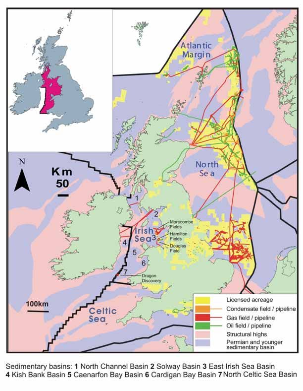
SEA6 GEOLOGY
                            ________________________________________________________________________
                                                       BRITISH GEOLOGICAL SURVEY

                                                    CONTINENTAL SHELF AND MARGINS
                                                     COMMISSIONED REPORT CR/05/057

                                        DTI Strategic Environmental
                                     Assessment Area 6, Irish Sea, seabed
                                      and surficial geology and processes
Keywords

Irish Sea, hydrocarbons
prospectivity, strategic
environmental assessment,
seabed processes, seabed
habitats, bathymetric charts,
seabed stress, seabed sediments,
seabed bedforms, sandwaves,
sandbanks, sand transport, deeps,
bathymetry, seafloor mapping.

Front cover

Terrain model of the submarine
study area and adjacent England,
Wales and Scotland. Submarine
vertical topography has been
exaggerated by 50 times and the
mainland topography has been
exaggerated by 10 times.
Topographic data for the
mainland of Ireland were not
available at the time of this
report.

Bibliographical reference
HOLMES, R, and TAPPIN, D R.
2005. DTI Strategic                  This document was produced as part of the UK Department of
Environmental Assessment Area        Trade and Industry’s offshore energy Strategic Environmental
6, Irish Sea, seabed and surficial
geology and processes. British       Assessment programme. The SEA programme is funded and
Geological Survey                    managed by the DTI and coordinated on their behalf by Geotek Ltd
Commissioned Report,
CR/05/057.                           and Hartley Anderson Ltd.

© Crown Copyright.
All rights reserved
                                                                                Edinburgh 2005

                                                            i
Foreword
As part of an ongoing programme, the Department of Trade and Industry is undertaking
Strategic Environmental Assessments prior to United Kingdom Continental Shelf licence
rounds for oil and gas exploration and production and consents for wind-farm renewable
energy developments. Before regional development proceeds, the Department of Trade
and Industry (DTI) consults with the full range of stakeholders in order to identify areas
of concern and establish best environmental practice. Stakeholders in a Strategic
Environmental Assessment (SEA) include the DTI, the general public, Non
Governmental Organisations (NGOs) (such as the Royal Society for the Protection of
Birds and the Worldwide Fund for Nature), local authorities, government agencies (e.g.
the Joint Nature Conservation Committee), experts in the field (universities, commercial
consultants etc.), the industries wishing to undertake the development and other marine
industries. The SEA process is used for predicting and evaluating the environmental
implications of a policy, plan or programme and provides a key input to decision making.
An SEA is conducted at a strategic level by the DTI - this contrasts with Environmental
Impact Assessment (EIA), which is carried out for a specific development or activity by
an operator.

An early step is an SEA scoping exercise to obtain external input to help define:

• the issues and concerns that the SEA should address
• key information sources and the current understanding of the natural environment and
how it functions
• perceived gaps in understanding of the effects of the activities that would result from oil
and gas licensing.

This technical report provides a summary of the hydrocarbons prospectivity of SEA6.
This is followed by a synthesis of the seabed and superficial geology of SEA6. Natural
historical and modern seabed processes are then summarized in relation to variations in
the seabed and superficial geology. These are directly related to variations in the
substrate properties of the seabed habitat.

In 1999 / 2000 the DTI conducted their first SEA of an area to the Northwest of Shetland
(formerly referred to as the "White Zone"). The figure below shows the general plan for
the SEA process where the numbering of the SEA areas indicates an initial order of
consultation for the SEA areas.

                                             iii
SEA6 GEOLOGY
________________________________________________________________________

                Setting of SEA6 in relation to other SEA areas

                                      iv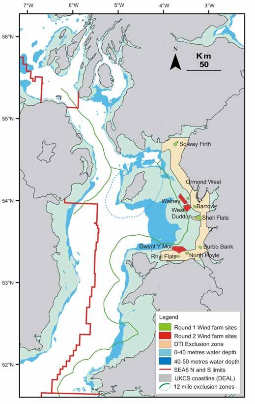
SEA6 GEOLOGY
________________________________________________________________________

Contents

Foreword .......................................................................................................................................iii

Contents.......................................................................................................................................... v

Executive summary ....................................................................................................................viii

1     Introduction ............................................................................................................................ 1

2     Hydrocarbons prospectivity.................................................................................................. 5
      Regional geological and infrastructural setting........................................................................ 5
      History of development............................................................................................................ 7
      Hydrocarbons geology ............................................................................................................. 7
      Prospectivity plays ................................................................................................................. 10

3     Seabed sediments, seabed habitats and sedimentary processes....................................... 12
      Seabed sediments ................................................................................................................... 14
      Processes influencing seabed sediment grain size and bulk composition.............................. 16
      Seabed bedforms .................................................................................................................... 27
      Net sand transport .................................................................................................................. 49

4     Strategic overview ................................................................................................................ 52
      Hydrocarbons prospectivity ................................................................................................... 52
      Sedimentary processes ........................................................................................................... 53

5     References ............................................................................................................................. 55

6     Glossary of terms.................................................................................................................. 58

Appendix 1               Sediment analyses and seabed-sediment classification ................................. 68

Appendix 2               Sediment waves ................................................................................................. 71

FIGURES
Figure 1 Location and infrastructure of producing gas and oil fields. ............................... 2
Figure 2 Location and infrastructure of windfarm development sites. .............................. 3
Figure 3 Regional geological setting and hydrocarbons infrastructure.............................. 6
Figure 4 Distribution of petroleum source rocks................................................................ 8

                                                                   v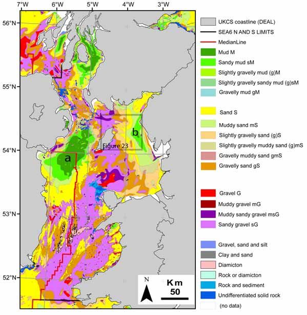
SEA6 GEOLOGY
________________________________________________________________________
Figure 5 Generalised geological profiles and petroleum prospectivity.............................. 9
Figure 6 Regional seabed physiographical and cultural setting. ...................................... 13
Figure 7 Seabed sediments. .............................................................................................. 15
Figure 8 a Mean peak spring tidal currents b Mean seabed stress.................................. 17
Figure 9 Constable Bank: physiography and environmental setting, August 2004. ........ 19
Figure 10 Annual mean significant wave height.............................................................. 21
Figure 11 Generalised distribution patterns of sub-seabed sediments. ............................ 24
Figure 12 Percentage carbonate in the seabed-sediment sand fraction, and locations of
    pockmark fields. ......................................................................................................... 26
Figure 13 Static bedforms ................................................................................................ 28
Figure 14 Example of seabed scour formed in mud around the Pisces Reef, an
    upstanding area of bedrock exposed at seabed........................................................... 30
Figure 15 Former pingo, a contributor to periglacial patterned ground. .......................... 31
Figure 16 Examples from static bedforms for asymmetry of sediment infill and sediment
    transport directions. .................................................................................................... 33
Figure 17 DTI 2004 surveys of shipwrecks and other man-made features..................... 34
Figure 18 Contrast in the geometry of small- to medium-sized a. biogenic and b. non-
    biogenic transverse bedforms ..................................................................................... 38
Figure 19 Generalised distribution patterns of mobile bedforms set between high seabed
    stress (bedrock/diamicton) and low seabed stress (smooth seabed / mudbelt) static
    bedforms. .................................................................................................................... 39
Figure 20 Schematic summary of the observed relationships between mean seabed stress
    and mobile and static bedforms, Irish Sea.................................................................. 40
Figure 21 Examples of fields of transverse small to very large sandwaves (a,b), boulders
    / mounded gravel (a, b), sand patches and gravelly sand patches (a) and a sand sheet
    (b), Liverpool Bay ...................................................................................................... 42
Figure 22 Schematic summary of the environmental settings and processes of formation
    of sandbanks, eastern Irish Sea................................................................................... 44
Figure 23 Regional physiographical and sand transport setting of banner banks east and
    west of the Isle of Man. .............................................................................................. 46
Figure 24 Ballacash Bank: extract of an image of the western (landward) head of an
    active banner bank. ..................................................................................................... 47
Figure 25 Wide estuary sand banks, River Ribble. .......................................................... 48
Figure 26 Net sand-transport pathways and directions. ................................................... 50
Figure 27 Wentworth grain-size scale used in sediment-size classifications for sediments.
    .................................................................................................................................... 69
                                                                   vi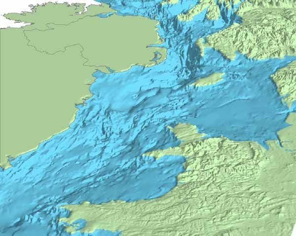
SEA6 GEOLOGY
________________________________________________________________________
Figure 28 Seabed-sediment classification scheme. .......................................................... 70
Figure 29 a. Generalised geometries and characteristics of sandwaves and tidal
    sandbanks related to tidal currents b. observed effects of wave-driven processes on
    tidal sandbanks and sandwaves .................................................................................. 71

TABLES
Table 1 Development of oil and gas producing fields........................................................ 7

                                                         vii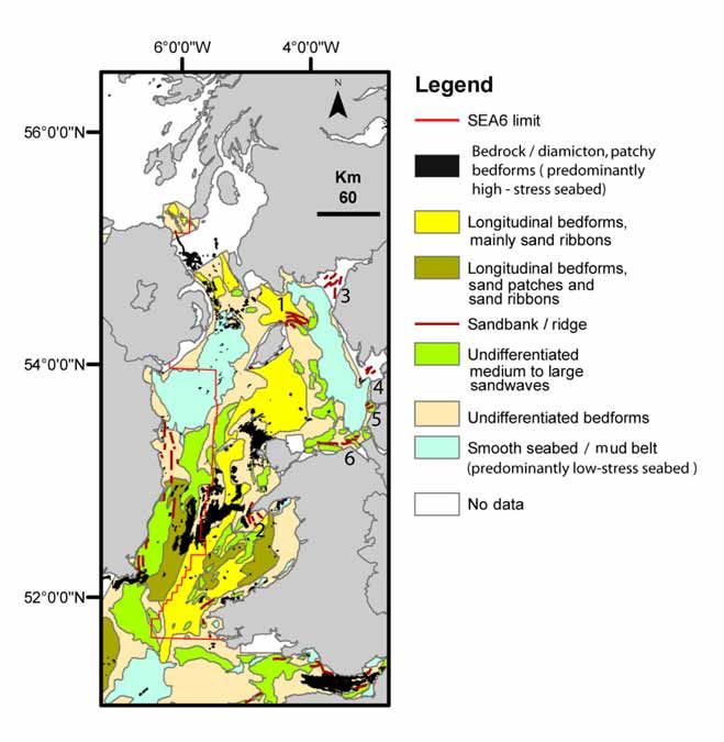
SEA6 GEOLOGY
________________________________________________________________________

                            Executive summary
Hydrocarbons prospectivity
   •   The East Irish Sea Basin is at a mature exploration phase.

   •   The hydrocarbons-prospective sedimentary basins are characterised by source
       rocks, an abundance of structured regional petroleum reservoir and seal rocks and
       by suitable timing of geothermal events for generation and transfer of petroleum
       products from the source rocks to the reservoir rocks.

   •   SEA6 has regionally diverse seabed habitats which vary significantly from area to
       area in currently licensed acreages in the eastern Irish Sea. The variations in
       seabed habitats have been systematically related to the sedimentary processes
       driven by quantifiable patterns of mean seabed stress.

Sedimentary Processes
   •   Open shelf seabed sedimentary processes are driven by seabed stress originating
       from interaction of the seabed with strong currents generated by tidal streams and
       by waves.
   •   The scale of the stress imposed on the seabed and the related seabed habitat
       variability varies from regional (between mainlands, varying shelter around
       headlands) to macroscopic (around boulders and pebbles).
   •   During the fair to moderate weather conditions characteristic of the late spring,
       summer and early autumn seasons, the seabed sediment types on the open
       continental shelf are dominated by the stress imposed on the seabed by the
       strengths and flow directions of the peak tidal currents. In this setting most of the
       regional variations in seabed sediment types are dominated by the effects of the
       coastal configurations on the tidal streams.
   •   In areas where the seabed stress from waves is dominant, the seabed sediments
       coarsen with exposure to the increasing seabed stress generated when the waves
       interact with the seabed. Seabed stress from waves is dependent on wave power
       that varies with weather, wave fetch, seabed slope, wave direction and water
       depth.
   •   There are knowledge gaps on possible regional variations of seabed properties
       when the seabed is stressed during extreme weather events associated with storm
       surge and storm waves.
   •   In the most highly stressed seabed environments, exposed bedrock and strongly
       cohesive unsorted gravelly, sandy and muddy sediments are often swept clean of
       unconsolidated muds, sands, granular gravel and pebbles. Parts of the seabed in
       these areas may consist of cobbles and boulders. Environments of least seabed
                                          viii
SEA6 GEOLOGY
________________________________________________________________________
        stress are characterised by fine-grained muddy sediments. Mobile sandwaves are
        characteristic of areas where sediments are being transported along the seabed in
        environments that are situated between the areas of extremely high seabed stress
        and very low seabed stress. The sense of regional seabed sediment transfer is from
        and across areas of high seabed stress to areas of lower seabed stress.
The observations summarised above indicate that if large-scale disruptions to the natural
seabed habitat are to be avoided, new development scenarios should avoid barriers that
could have a significant effect on the regional patterns of seabed stress.
   •    As elsewhere on the UKCS, glacigenic sediments and relict static glacigenic
        bedforms have had significant regional and local effects on the patchiness of the
        distribution patterns of seabed sediments and seabed habitats.
   •    There is a knowledge gap in the research evidence required to securely link sub-
        regional increases in the percentage of biogenic carbonate in the sand fraction of
        the Irish Sea Mud Belt with increased biological productivity of surface waters,
        with methane expulsion from shallow and seabed sediments or with processes of
        bedload carbonate transport.
   •    Investigations of shipwrecks and artificial continuous barriers indicate that the
        amount of seabed scour is much larger than the profile of large seabed obstacles
        presented to near-bed current flow. The observations reveal patterns of scour
        asymmetry consistent with model predictions of mean peak tidal current speeds
        and the interpretations of the directions of regional sediment transport based on
        the geometries of seabed bedforms. Wreck studies could therefore be used to
        calibrate modelling on the likely long term effects of future seabed development
        scenarios. Shipwrecks have also contributed to seabed diversity.
   •    Active pockmarks, bioherms, banks in less than 20m water depth and some
        shipwrecks are already regulated by conservation measures. The following
        geological features are also worthy of consideration for preservation because they
        are irreplaceable:

       Static bedforms       —     sarns, pingos, upstanding rock outcrops in mud belts
       Mobile bedforms       —     banner banks, estuary banks and spits

   •    A gateway for sand exchange between the open shelf and the eastern Irish Sea
        coast off England appears to be defined by a zone situated between North Wales
        and the southern limit of the Eastern Irish Sea Mudbelt. Although the current
        prospects for large oil and gas developments in this area are very small, any
        developments that could the patterns of sand exchange through this
        environmentally sensitive area should be avoided.

                                            ix
SEA6 GEOLOGY
________________________________________________________________________

1 Introduction
The Strategic Environmental Assessments (SEA) are designed to consider all of the
marine environment with the main focus on areas that may be affected by the activities of
the oil and gas or renewable energy industries. Parts of the SEA6, for example inshore
areas, bays and inlets, are not currently considered prospective for non-renewable or
renewable energy developments or for other reasons may be prohibited from future
energy developments. Although such areas may not attract much attention from the oil
and gas or renewable energy industries, they are included in this report in order to
consider the marine environment as a whole.
SEA6 covers 10 oil and gas commercial quadrants and 13 named developed gas and oil
fields in the Irish Sea (Figure 1). Some of the blocks within those commercial quadrants
are unlicensed at present, but may be offered for licensing within the 23rd Oil and Gas
Round to take place during 2005. With regard to windfarm development, licencing under
Round 1 has resulted in seven named windfarm sites. Under Rounds 2 and 3, sites are at
present under consideration (Figure 2).

                                           1
SEA6 GEOLOGY
________________________________________________________________________
Figure 1 Location and infrastructure of producing gas and oil fields.
2SEA6 GEOLOGY
________________________________________________________________________
Figure 2 Location and infrastructure of windfarm development sites.
3SEA6 GEOLOGY
________________________________________________________________________
In 2002, the British Geological Survey under a commission from the Department of
Trade and Industry (DTI) carried out an inventory of geological metadata for SEA6
(Tappin et al., 2002). The location of existing and proposed energy developments in the
shallow water of the eastern Irish Sea supported a case for new seabed surveys to
improve our understanding of the active sedimentary processes and their likely impact on
windfarm development infrastructure.
A Scoping Study in 2004 (Tappin et al., 2004) was completed with the objective of
determining the primary sites for the marine surveys. It was based on a combination of
the existing regional knowledge of sedimentary processes operating in the area, and on a
new report (Kenyon and Cooper, 2004) that reviewed the understanding of sand banks,
sand transport and relationships to offshore windfarm development on the UK
Continental Shelf. As a result of the study, five primary areas were identified for survey
in the East Irish Sea area: Outer Solway Firth, Northeast Isle of Man, Morecambe Bay,
outer Liverpool Bay and North Wales coast. The objective of the surveys was to provide
data to test models of sediment movement in the East Irish Sea area.
The format defined by the contract for this report is:
• Executive Summary
• Introduction
• Hydrocarbon prospectivity
• Distribution of seabed sediments and a description of seabed sedimentary processes
• Strategic overview
• References
• Glossary of terms used in the text
The report data have been compiled and presented in the figures using the Arc9
geographical information system (GIS) based on spheroid and datum WGS 84, UTM
zone 30 projection and origin 3 degrees west. The data incorporated into the BGS series
of published 1:250,000 maps provide much of the seabed information presented in the
GIS. This report also incorporates the data generated from the new seabed surveys
completed in August 2004 during Survey Vessel Meridian Cruise A (Holmes et al.,
2004). A glossary has been compiled of the technical terms used in this report (section
6).
4SEA6 GEOLOGY
________________________________________________________________________
2 Hydrocarbons prospectivity
The following account is largely based on data published by the Department of Trade and
Industry (Dti, 2004) .
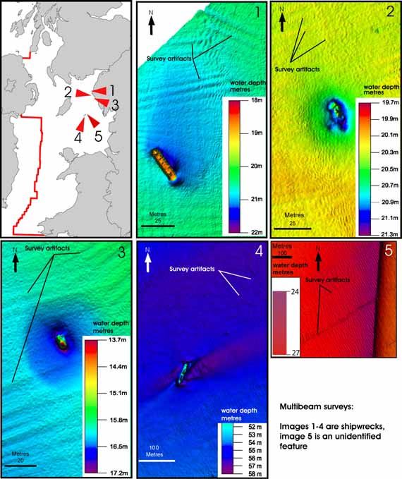
REGIONAL GEOLOGICAL AND INFRASTRUCTURAL SETTING
The main sedimentary basins within the United Kingdom Continental Shelf (UKCS) are
divided into separate provinces on the basis of their petroleum geology and location.
SEA6 encompasses the Irish Sea province, which can be subdivided on the basis of
regional geological structure into seven major sedimentary basins (Figure 3). To date,
discoveries of hydrocarbons have been gas in the East Irish Sea Basin and Cardigan Bay
Basin / North Celtic Sea Basin and oil in the East Irish Sea basin. Commercial quantities
of oil and gas are currently produced only from the East Irish Sea Basin (Table 1).
5SEA6 GEOLOGY
________________________________________________________________________
Figure 3 Regional geological setting and hydrocarbons infrastructure.
Figure 3: see Figure 2 for details of oil and gas field locations.
6SEA6 GEOLOGY
________________________________________________________________________
HISTORY OF DEVELOPMENT
Exploration of the UKCS has proceeded at a rapid rate, stimulated by the frequency and
regularity of licensing rounds. Since 2000 these have been preceded by DTI Strategic
Environmental Assessments (SEAs). A history of some of the developments of the
producing oil and gas fields in SEA6 is summarized in Table 1.
Table 1 Development of oil and gas producing fields.
Field name Main type of Discovery Production Original estimate of
production date start recoverable reserves
North Morecambe Gas 1976 1994 27.90 billion cu m
South Morecambe Gas 1974 1985 144.40 billion cu m
Hamilton North Gas 1991 1995 5.34 billion cu m
Hamilton Gas 1990 1997 14.33 billion cu m
Douglas Oil 1990 1996 13.31 million tonnes
Bains Gas 1974 1985 144.40 billion cu m
Calder Gas No information
Dalton Gas 1990 1999 2.87 billion cu m
Darwen Gas No information
Lennox Gas 1992 1996 10.31 billion cu m
Oil 1992 1996 10.11 million tonnes
Millom Gas 1982 1999 6.07 billion cu m
Ormonde South Gas No information
Table 1 has been compiled from information from the DTI released in hardcopy up to
2001 and from the DTI website to 2005.
HYDROCARBONS GEOLOGY
Commercial oil and gas accumulations are generated when petroleum source rocks and
seal reservoir rocks are configured adjacent to reservoir rocks with structural and/or
stratigraphical closure. Source rocks have then to be matured by geothermal heat at
suitable times for the petroleum to be generated and transferred into the sealed reservoir
rocks. Areas with Jurassic mudstones with world-class oil potential, Carboniferous oil-
prone basinal mudstones and Carboniferous gas-prone coal measures in the North
Channel and Solway Basins possibly indicate some of the best scenarios for future
commercial petroleum discoveries (Figures 4, 5).
7SEA6 GEOLOGY
________________________________________________________________________
Figure 4 Distribution of petroleum source rocks.
Hydrocarbons-prospective sedimentary basins in SEA6 are characterised by source rocks
and an abundance of regional petroleum reservoir and seal rocks (Figures 4, 5). The
timing of geothermal and structural events has also been suitable for generation, transfer
8SEA6 GEOLOGY
________________________________________________________________________
and trapping of petroleum products from source rocks to the reservoir rocks.
Figure 5 Generalised geological profiles and petroleum prospectivity.
Figure 5: a is adapted after Tappin et al (1994), b and c are adapted after DTI (2004).
For profile locations a, b, c see Figure 4.
9SEA6 GEOLOGY
________________________________________________________________________
PROSPECTIVITY PLAYS
East Irish Sea Basin
The East Irish Sea Basin (Figure 3) is at a mature exploration phase, having produced oil
and gas since 1985 (Table 1).
Early Namurian basinal mudstones are the source rocks for the hydrocarbons. Production
from all fields is from fault-bounded traps of Lower Triassic, principally aeolian
Sherwood Sandstone reservoir, sealed by younger Triassic continental mudstones and
evaporites. Future exploration will initially concentrate on extending this play, but there
remains largely untested potential also for gas and oil within widespread Carboniferous
fluvial sandstone reservoirs. This play requires mudstone seal units to be present, as there
is no top-seal for reservoirs subcropping the regional base-Permian unconformity in the
east of the basin, and Carboniferous strata crop out at the seabed in the west.
Caernarfon Bay Basin
The Caernarfon Bay Basin (Figure 3) contains up to 7 km of Permian and Triassic
sediments in an asymmetrical faulted basin that is bounded to the north and south by
Lower Palaeozoic basement with no reservoir or source potential.
Only two exploration wells have been drilled so far, and there remain numerous undrilled
targets in the tilted fault block plays that are characteristic of this basin (Figure 5). As in
the East Irish Sea Basin, the principal target reservoir is the Lower Triassic, Sherwood
Sandstone, which is top-sealed by younger Triassic mudstones and evaporites. Wells in
the Irish Sector to the west have demonstrated that pre-rift, Westphalian coal measures
are excellent hydrocarbon source rocks. These are at peak maturity for gas generation
(Maddox et al., 1997). Seismic profiles clearly image these strata continuing beneath a
basal Permian unconformity into at least the western part of the Caernarfon Bay Basin.
The timing of gas generation presents the greatest exploration risk. Maximum burial of
source rocks, and primary gas migration from the source rocks could have terminated as
early as the Jurassic. Many of the tilted fault blocks were reactivated or created during
Palaeogene inversion of the basin. It is also possible that a gas charge occurred during
regional heating associated with intrusion of Palaeogene dykes, such as those that crop
out nearby on the coastline of North Wales. This second phase of hydrocarbon generation
has been invoked as an important factor in the charging of the East Irish Sea Basin’s oil
and gas fields (Floodpage et al., 2001). Fault block traps could also have been recharged
by exsolution of methane from formation brines as a direct result of the Cainozoic uplift
(Doré and Jensen, 1996) .
Cardigan Bay Basin
The Cardigan Bay Basin forms a continuation into UK waters of Ireland’s North Celtic
Sea Basin (Figure 3). The Cardigan Bay Basin comprises a south-easterly deepening half-
graben near the Welsh coastline, with an internal structure that becomes increasingly
complex towards the south-west. Permian to Triassic, syn-rift sedimentary rocks within
10SEA6 GEOLOGY
________________________________________________________________________
the basin are less than 3 km thick and are overlain by up to 4 km of Jurassic strata, and
locally also by up to 2 km of Palaeogene fluviodeltaic sediments. The basin has a proven
petroleum system, with potentially producible gas reserves at the Dragon discovery near
the UK/Ireland median line (Figure 3). There are oil shows in a further three wells.
The Cardigan Bay Basin contains multiple reservoir targets (Figure 4), which include the
Lower Triassic (Sherwood Sandstone), Middle Jurassic shallow-marine sandstones and
limestone (Great Oolite), and Upper Jurassic fluvial sandstone, the reservoir for the
Dragon discovery. The most likely hydrocarbon source rocks are early Jurassic marine
mudstones (Lias Group). These are fully mature for oil generation in the west of the UK
sector, and are mature for gas generation nearby in the Irish sector. Gas-prone,
Westphalian pre-rift coal measures may also be present at depth locally. The Cardigan
Bay Basin underwent two Cainozoic phases of compressive uplift, whereas maximum
burial that terminated primary hydrocarbon generation was probably around the end of
the Cretaceous, or earlier if Cretaceous strata, now missing, were never deposited in the
basin. Despite the Cainozoic deformation, the Dragon discovery has proved that
potentially commercial volumes of hydrocarbons were retained at least locally in
Cardigan Bay. In addition to undrilled structural traps, the basin contains untested
potential for stratigraphical entrapment of hydrocarbons near syn-sedimentary faults,
especially in the Middle Jurassic section.
11SEA6 GEOLOGY
________________________________________________________________________
3 Seabed sediments, seabed habitats and sedimentary
processes
The method adopted for description of seabed habitats in this report broadly follows the
approach adopted by the Joint Nature Conservancy Council: in the absence of detailed
biological data, marine habitat types can be identified from variations in seabed
physiography and seabed-sediment properties (Golding et al., 2004). In turn, these are
derived from interpretations of seabed-sample data, geophysical data and hydrographical
data. Maps of seabed physiography and seabed-sediment properties are separated for
clarity of presentation in this report. A summary of some of the procedures and
classification schemes used for acquiring and processing seabed samples for seabed-
sediment mapping is in Appendix 1. Figure 6 summarises the regional physiographical
and cultural setting of the seabed in SEA6.
12SEA6 GEOLOGY
________________________________________________________________________
Figure 6 Regional seabed physiographical and cultural setting.
Figure 6: Physiographical data are adapted from the BGS digBATH dataset. See
Frontispiece for an illustration of a digital terrain model that links the physiography of
mainland Wales, England and Scotland with the seabed physiography.
13SEA6 GEOLOGY
________________________________________________________________________
SEABED SEDIMENTS
Sediment grains are winnowed on the seabed depending on how strong the near-bed
currents are in relation to the threshold speeds of near-bed currents required for grain
suspension into seawater and grain bedload transport. The seabed-sediment grain-size
distribution patterns reflect the exposure of the seabed to winnowing processes, which are
driven by the stress put on the seabed by directional ocean, wind, storm surge and tidal
currents and by non-directional currents from wind and swell waves. The regional trend
is for sediment grains to move across or away from seabed with higher stress towards the
seabed with a lower stress. The amount of stress imposed on the seabed and thus the
amount and type of sediment imported into, deposited, or exported out of the study area
varies with position and time. As a result, in areas of seabed scour and grain bedload
transport, there are continuous processes of sediment reworking and redistribution
resulting in ‘ seabed polishing’. The end-members of the processes driving sediment
transport and deposition are large areas of (a) exposed bedrock and exposed strongly
cohesive unsorted gravel, sand and mud (collectively termed diamicton: explanation
Section 6, Glossary) and (b) muddy sediment (see Figure 27 for a definition of the range
of grain sizes commonly found in mud). Large areas of exposed rock and diamicton are
swept clean of unconsolidated sand in the most highly stressed seabed environments,
perhaps leaving some pebbles, cobbles and boulders (collectively termed gravel, see
Figure 27). Areas of least seabed stress are characterised by more or less stable fine-
grained muddy sediments, significant proportions of which have been deposited from
suspension in conditions where there are very low seabed currents (Figure 7).
14SEA6 GEOLOGY
________________________________________________________________________
Figure 7 Seabed sediments.
Figure 7: Data sourced from the BGS series regional 1:250 000 scale maps of seabed
sediments. The large areas of mud, sandy mud, muddy sand and slightly gravelly muddy
sand characterised by a smooth and relatively featureless seabed in the Irish Sea are
referred to as the a Western Irish Sea Mudbelt and b Eastern Irish Sea Mudbelt. See
Appendix 1 for an explanation of the methodology and terms used to describe variations
in seabed sediment types.
15SEA6 GEOLOGY
________________________________________________________________________
PROCESSES INFLUENCING SEABED SEDIMENT GRAIN SIZE AND BULK
COMPOSITION
An analysis of the oceanography of the study area is presented by Proudman
Oceanograpic Laboratory in this 2005 DTI SEA6 technical report series (Howarth, 2005).
The purpose of the following account is to tie variation in the hydrography with regional
variations in seabed sediment properties and processes.
3.1.1 Tides
The tides propagate from the Atlantic Ocean to the north through from the Celtic Sea and
to the south through the North Channel. The areas where the tidal fronts meet adjacent to
the Isle of Man are characterised by relatively weak peak tidal currents. There is an
overall very strong correlation between the annual mean peak tidal currents and annual
mean seabed stress (Figure 8). The strong correlation between the distribution patterns of
coarser sediments and the stronger mean peak spring tidal currents establishes that the
stress put on the seabed by the tidal currents is a major influence on sediment
composition. The positive correlation between the stronger mean peak tidal currents and
seabed stress with constrictions to tidal flow by coastal configuration also means that on
the open continental shelves of the north Celtic and Irish Sea and the North Channel there
is little regional correlation between the water depth and sediment composition (Figures
6,7,8).
16SEA6 GEOLOGY
________________________________________________________________________
Figure 8 a Mean peak spring tidal currents b Mean seabed stress.
Figure 8: a: sourced from the DTI Atlas of Renewable Energy (2004), and modelled for
mid-water currents averaged over 1 year. b: modelled by Proudman Oceanographic
Laboratory for seabed stress forced by tides and winds averaged over 1995-1997
(J.N.C.C., 2004); Figure 7 in(Howarth, 2005).
Mid-water mean peak spring tidal currents of 1m/s
encompasses most areas of sandy gravel, and >1.25m/s encompasses the distribution of
gravel and exposed rock and diamicton at seabed.
3.1.2 Climate
Wind drives directional sea-surface wind currents and storm surge currents. Wind also
drives non-directional rotational near-bed currents. These are generated when wind
waves and swell waves interact with the seabed to stir it up. The effects of swell and wind
waves on processes of seabed erosion and seabed sediment transport varies with the wave
fetch, seabed gradient and tidal range. The Solway Firth, Morecambe Bay and Liverpool
Bay, with the highest mean spring tidal range (>6m) andSEA6 GEOLOGY
________________________________________________________________________
exposure to stresses from tidal currents varies more predictably with constrictions to the
cyclical flood and ebb tidal streams.
One effect of wave interaction with seabed in shallow water is a tendency to flatten
sandwaves and other mobile seabed bedforms that may have been previously built up by
the tidal currents (Appendix 2: Figure 27 b). This process re-distributes sediments
laterally and contributes to widening of banks and ridges on the open shelf and flats in
estuaries. If the stresses imposed on the seabed by wind-driven currents and waves
prevail from one direction, the stress asymmetry also imparts geometrical asymmetries to
seabed banks and ridges. Such effects are illustrated on Constable Bank, the crest of
which defines a submarine sand spit that extends to the west from the Rhyl Flats on the
approaches to the River Dee Estuary (Figure 9). The bank was surveyed during the DTI
SEA6 surveys in August 2004 immediately following northerly gales. The waves that
were generated during the gales appear to have flattened the crests of east-migrating, very
large sandwaves formed on the north flanks of Constable Bank and, consistent with the
interactions between the tidal and wind-driven processes summarised above, the steeper
south flank faces away from the direction of waves with historically the longest fetch.
The large-scale asymmetry of the bank facing direction appears to be long standing as it
is also registered on Admiralty Chart number 1971 (Constable Bank surveyed 1927-
1929). Because of this asymmetry, it is expected that over the long term the Constable
Bank is migrating towards the North Wales coast. The overall shape of Constable Bank
also widens and flattens to the east where the bank shallows and merges with the Rhyl
Flats (Figure 9).
18SEA6 GEOLOGY
________________________________________________________________________
Figure 9 Constable Bank: physiography and environmental setting, August
2004.
Figure 9: Image extracted from the DTI 2004 SEA6 survey dataset. BGS regional sample
data indicate that the bank is composed of sand, and the surrounding seabed in more
than approximately 20 m water depth is composed of slightly gravelly sand.
A plot of the areas of seabed in less than 15m water depth imposed on areas with low
peak tidal speeds gives a nominal indication of the shallow water areas with potential for
wave interaction with the seabed in fair-weather conditions (Jackson et al., 1995) (Figure
10). These are areas where the wind-driven surface currents, or wind and waves driving
longshore drift are likely to have a significant effect on seabed composition and near-bed
19SEA6 GEOLOGY
________________________________________________________________________
sediment transport. Such areas vary from very narrow bands around the sheltered margins
of the Scottish sea lochs to wider ramps of wave dominance in the eastern Irish Sea,
including Cardigan Bay. A prediction for the effect of swell and wind-wave dominance in
part of Cardigan Bay goes towards explaining why the seabed there is characterised by
sands and gravels, and the sarns by gravels, even though the water depths and (relatively
low) mean peak spring tidal currents are comparable to those associated with the Eastern
Irish Sea Mudbelt (Figures 8, 10).
20SEA6 GEOLOGY
________________________________________________________________________
Figure 10 Annual mean significant wave height.
Figure 10: Data sourced from the DTI Atlas of Renewable Energy (2004).See Glossary
Section 6 for a definition of significant wave height.
Regional trends of changes in annual mean significant wave height occur where the open
21SEA6 GEOLOGY
________________________________________________________________________
shelf areas are exposed to prevailing wind and swell waves originating from the south-
west and from the north-west (Figure 10). Exposure to the largest waves is most
pronounced on coasts and submarine shoals facing the longest fetches and in
environments where the wave energy has been least dissipated by the interaction of the
waves with shoaling seabed. Such areas occur off southern Wales, the Lleyn Peninsula,
Anglesey and the Isle of Man. These areas are also characterised by very high stress
imposed on the seabed by strong tidal currents (Figure 8) so that the waves are only
expected to have a dominant effect on the seabed when mean significant wave height is
enhanced during the more severe weather conditions.
Observations off the Isle of Man from gravel waves in 50 m water depth where the wave
orientations were unrelated to the tidal streams, indicate that gravel may be occasionally
mobilised at such depths by long-period storm waves (Jackson et al., 1995). In the Irish
Sea, winds of storm force and higher are recorded on average for 35 to 45 days a year
(Hydrographic Department, 1960). The lack of observations of the regional changes
forced on the seabed composition during storm conditions are a significant gap in our
knowledge. This is because most of the data collected during sampling and geophysical
surveys used for the BGS interpretations of variation in seabed sediments have been
acquired in fair weather during the spring, summer and early autumn months over a total
survey period of approximately 20 years since 1972. The possible impact of seasonal
climate change on the regional pattern of sediment distribution has not been investigated
during the BGS regional sampling programme. However, the strong correlations
between annual mean tidal current strength and the regional sediment distribution
patterns appear to show that the local effects of storms on seabed composition and
bedforms are repaired during the relatively long periods of fair to moderate weather.
In areas of high seabed stress the environment will rapidly respond to changes. Thus, for
example, drill cuttings released to the seabed will be rapidly dispersed from their origin.
The seabed will also rapidly change both shape and sediment grain-size composition in
response to stress patterns generated when near-bed currents are diverted around
permanent seabed fixtures.
3.1.3 Historical seabed evolution
The seabed is composed of outcrops of bedrock and glacigenic sediments that form relict
seabed features covering approximately 10% of the area of SEA6. In the other areas,
relatively thin mobile seabed sediments transit across an variety of thick relict sediments.
The influence of historical processes on the properties of relict seabed and relict
superficial features are therefore summarised in this section.
Historical coastline shifts around the British Isles have occurred with adjustments to
large-scale vertical movements of the Earth’s crust, the largest of which was more than
500 m uplift and then long-term subsidence since approximately five million years ago
(Japsen, 1997). On these movements were imprinted global sea-level changes and
regional differences of vertical crustal movements. These changes were due to unloading
and loading of crust by ice and sediments, particularly after approximately 760 000 years
ago, when there was a shift to larger polar ice volumes (Funnel, 1995). This period
included seven major glacial periods of approximately 80 000 to 120 000 years duration,
22SEA6 GEOLOGY
________________________________________________________________________
when global sea level fell to 100 m or less below present level. The geological evidence
is that at least three regional glaciations have profoundly moulded the seabed
physiography and shallow sub-seabed sediments in SEA6 (Wingfield, 1989) .
During the maximum of the last major glacial period, approximately 21 000 to 17 000
years ago, sea level in the Celtic Sea was possibly 135 m below present (P Bouysse,
1976) and a land bridge linked Ireland with England and Wales (Lambeck, 1996).
Between the major glacial and interglacial periods there were other significant climate
and global sea-level changes of 1000 to 3000, sometimes 5000 years or more average
periodicity (e.g.(Clapperton, 1997). During these times the sea level probably fluctuated
in SEA6 over a range of less than 10m to 50 m or more.
At the maximum of the last glaciation, the regional ice sheets had merged across much of
the northern British Isles and flowed south (Lambeck, 1995). In areas where the main
stream of ice flow was accelerated, it gouged major north–south and north-west–south-
east elongated basins into the rock. The largest and deepest of these occur in the northern
SEA6 and have contributed significantly to seabed habitat diversity (Frontispiece, Figure
6).
By cutting through regional variations in hardness and composition of rockhead and
unlithified strata, the ice reworked and then redeposited a wide variety of sediments
(Figure 11). During the waning stages of the last glaciation and as the ice retreated, it
deposited fluvial outwash and also left behind unsorted gravelly, sandy and muddy
sediments (diamicton, definition Section 6) over the areas that it had previously eroded.
The diamicton was subsequently resistant to marine erosion and is the main sediment
type underpinning the seabed sediments (Figure 11).
The sea rose to reconnect the North Channel with the Celtic Sea after approximately
16 000 years ago (Lambeck, 1995; Lambeck and Purcell, 2001). By the early part of the
present interglacial, approximately 8 300 years ago, much of SEA6 was submarine, by
which time a fully marine connection had also been re-established between the North Sea
and the English Channel (Jelgersma, 1979) and the currents from wind and swell waves
and strong tidal streams once again shaped the seabed.
There continue to be predictable modern net vertical coastal and offshore movements.
These are driven by the interactions between postglacial global sea-level rise and crustal
movements that are part of a continuing gradual response to historical changes in crustal
loading due to former ice melt and the transfer of rock and unconsolidated sediments.
Such adjustments are reflected in a modern maximum net rate of vertical land and seabed
uplift of approximately 1.1 mm/yr in the northern SEA6 compared to a fall in the
southern SEA6 of approximately 0.5 mm/yr (Shennan and Horton, 2002). The
adjustments are unrelated to natural seismicity and they do not pose a significant safety
risk to future seabed developments related to oil and gas.
The overall geological perspective is for rapid 1000 to 100 000 year or more cyclical
changes in subglacial and submarine processes of erosion and deposition. As summarised
above, these changes have played a pivotal part in shaping the large-scale physiography
of the modern seabed. Another lasting impact of the rapid evolution of the seabed has
been that the superficial strata below the seabed sediments vary on a sub-regional basis
23SEA6 GEOLOGY
________________________________________________________________________
and have significantly different properties to those of the seabed sediments (Figures 7,
11). As a result, new developments which require foundations set below the seabed are
likely to encounter geohazards that could affect the safety and cost of seabed and shallow
sub-seabed development operations.
Figure 11 Generalised distribution patterns of sub-seabed sediments.
Figure 11: based on interpretations of high-resolution seismic reflection-records
integrated with core samples in the range of 1 to 5 m or more below seabed. Nominal
distribution patterns are simplified from the BGS 1:1 million and 1:250 000 scale
regional maps (Holmes et al., 1993, 1994).
The minerological composition of the seabed sediments has also evolved with time and
climate change. For example, former sub-ice and ice-proximal diamictons and fluvial
muds, sands and gravelly sediments on the open continental shelf originally consisted of
24SEA6 GEOLOGY
________________________________________________________________________
rock and silica-rich grains with no carbonate biota or few carbonate biota with little
biodiversity. Modern submarine sediments consist typically of a mixture of reworked
glacigenic and fluvial sediment grains and 5 to 20 weight % or more biogenic carbonate
fragments that have mainly originated from fossil biota living in post-glacial times. There
is a strong overall correlation between high concentrations of seabed biogenic carbonate
in sands associated with strong tidal currents. Thus, the proportion of carbonate grains in
the sand fraction of the modern seabed sediments increases with the mean grain size.
With the exception noted for areas of pockmarks (page 31), the proportion of biogenic
carbonate is highest in the sand fractions of the coarsest seabed sediments. A bias is for
preservation of fragments of many of the modern shelly biota in sandy seabed sediments
exposed to relatively high average seabed stress (Figures 7, 8 12). These observations
suggest that modern physical processes have a strong influence on the chemical
composition of the seabed sediments.
25SEA6 GEOLOGY
________________________________________________________________________
Figure 12 Percentage carbonate in the seabed-sediment sand fraction, and
locations of pockmark fields.
Figure 12: Locations of pockmark fields updated using the DTI 2004 SEA6 survey
dataset. Adapted from the BGS regional mapping (Pantin, 1991).
26SEA6 GEOLOGY
________________________________________________________________________
SEABED BEDFORMS
Seabed bedforms can be broadly classified into static and dynamic bedforms.
Static bedforms
Static bedforms are important because they provide stable sites for distinctive biota and,
where occurring in isolation, they contribute to the local diversity and patchiness of the
seabed habitat. By redirecting the stress imposed on the seabed by the directed currents,
the static bedforms also generate useful indicators of the direction of bedload sediment
transport. Excepting shipwrecks, pipelines, power cables, telephone cables and the static
bedforms built up by living biota (bioherms or reefs), the static bedforms provide
snapshots of former terrestrial, submarine, glacial, periglacial and early postglacial
features and processes (Figure 13).
27SEA6 GEOLOGY
________________________________________________________________________
Figure 13 Static bedforms
Figure 13: See Figure 16 for the distribution of shipwrecks surveyed by the DTI in 2004.
Adapted after BGS regional reports (Fyfe et al., 1993; Tappin et al., 1994; Jackson et al.,
1995), the Joint Nature Conservation Committee (2004) database for Modiolus and
modified by results from the DTI 2004 SEA surveys.
28SEA6 GEOLOGY
________________________________________________________________________
ROCK AND DIAMICTON
The largest areas of outcrops of rock, rock and sediment and diamicton occur with rough
and very varied seabed topography, usually with seabed gravels, in areas of very high
seabed stress and seabed scour (Figures 7, 8). Some rock outcrops, such as the roche
moutonnée, were formed subglacially and have an elongated form with a tail pointing
south indicating the direction of former ice movement. Off Anglesey, steep slopes of 20°
to 30° or more and 10 to 40 km or more in length form prominent scarps composed of
glacigenic and rock strata (Figure 13). The scarps are subparallel to regional fault patterns
in the underlying solid rock. They are locally aligned to the modern Anglesey coast and
may have been partly eroded by ice. They are also thought to align with former tidal
straits (Figure 13) (Jackson et al, 1995). They are important because the areas in which
they occur are characterised by some of the strongest modern peak mean spring tides, the
diversion of which is likely to lead to near-bed current acceleration and distinctive seabed
habitats. Gas seepage has also been mapped by the BGS as being coincident off Anglesey
with a major fault. The fault separates Mesozoic sedimentary rocks to the west from
basement rock that forms the bulk of the Anglesey Platform. This fault may act as a gas
migration route. Such seepage has been identified from seismic-reflection records but it
has not been verified by sampling. (Judd, 2005) (this technical report series) has
identified other areas with a possible connection between former straits and methane-
derived authigenic carbonate.
Where rock outcrops in the Western Irish Sea Mudbelt, an unusual environment is found
where thin seabed sediments sit directly on the upstanding rock. In this case, the rock
outcrop is not an indication of a very high energy environment, rather it is isolated
because it has not yet been buried by mud deposited from suspension. The exposed rock
faces are swept clean of fine-grained muddy sediments because of acceleration of weak
near-bed currents around an upstanding obstacle. The Pisces Reef provides an example of
such an environment (Figure 14). The feature provides a refuge habitat, partly because
the upstanding rock is hazardous to near-bed commercial fishing operations. Ledges and
pinnacles formed on jointed rock and steeply dipping strata also provide habitat niches of
very hard and very soft substrates. A north-extended scour moat around the east margin
of the Pisces Reef was probably eroded by tidal flow. Other isolated and upstanding
seabed crops of rock and diamicton that are set in unconsolidated sediments also provide
discrete patches of diverse habitats set in otherwise relatively uniform seabed (Figure 21).
29SEA6 GEOLOGY
________________________________________________________________________
Figure 14 Example of seabed scour formed in mud around the Pisces Reef, an
upstanding area of bedrock exposed at seabed
Figure 14: Image extracted from the DTI 2004 SEA6 survey dataset.
30SEA6 GEOLOGY
________________________________________________________________________
PERIGLACIAL FEATURES
Evidence on the seabed of former periglacial terrestrial environments includes fossil ice-
wedge polygons that are 15 to over 80 m in diameter (Wingfield, 1987) and former
pingos. Examples of patterned seabed formed on fossil ice-wedge polygons were not
observed during the DTI 2004 surveys.
Pingos are formed in modern arctic permafrost conditions in terrestrial, lacustrine and
submarine environments when an ice core, usually in poorly drained or flooded soils, has
expanded to push up sediments into domes. The domes typically vary from 10-500m
diameter, larger if the pingos have formed under lake beds. The surface sediments on the
pingos move downslope and collapse as the ice melts, leaving a crater and rim, the form
of which may or may not be enclosed. In the example shown (Figure 15) a horseshoe-like
raised rim of approximately 200 to 300 m diameter has formed. The rim is interpreted as
the perimeter of a pingo that originated in former permafrost conditions. The BGS
regional data indicate that the pingo is set over an area of sub-seabed diamicton. It is
preserved with relatively smooth flanks that is set in a field of modern active submarine
sandwaves (Figure 9) composed of slightly gravelly sand. The pingo flanks have not been
sampled, but the patches of low sonar backscatter around the pingo (not illustrated) are
interpreted as areas with gravel-free seabed sand or muddy sand that have added to the
natural seabed diversity.
Figure 15 Former pingo, a contributor to periglacial patterned ground.
Figure 15: Image extracted from the DTI 2004 SEA6 survey dataset.
31SEA6 GEOLOGY
________________________________________________________________________
Habitat diversity has also been generated over varied topography on drowned former
river channels (rias), estuaries, deltas and braided sandhur plain channels, many of which
were probably sited adjacent to former ice margins (Jackson et al., 1995). The sarns are
composed of ridges of boulder to pebble-size gravel, and are thought to be relicts of
lateral moraines of glaciers that formerly extended to the west from the mainland of
North Wales into the Irish Sea. In Cardigan Bay, the sarns appear to be truncated at their
west ends (Figure 13), which is thought to have occurred at times during the last
glaciation when the dominant ice stream was moving south. Former subaerial channels
extend into some enclosed basins, for example, the Beaufort’s Dyke which at times of
severe climate and very low sea level were likely to have been freshwater lochs (Figure
13). The pingos and sarns provide examples of unusual features which have no short-term
potential for regeneration. For these reasons they may be suitable for preservation from
damage during future seabed developments.
NARROW ENCLOSED DEEPS
Narrow enclosed deeps are static bedforms relict from subglacial ice gouging
(Frontispiece). Modern Scottish sea lochs provide some of the most spectacular
examples of these features. Lune Deep (Figure 16) is also relict from ice scour from
former ice sheets that have flowed at various times to the south and west from mountain
sources in the Lake District. The northern flanks of Lune Deep are composed of exposed
bedrock with a rugged seabed physiography. This observation suggests that the northern
flanks of Lune Deep are set in an area of modern sediment bypass. In contrast, the
southern flank consists of a smooth seabed which is a sink for muddy sands (Figure 68 in
Jackson et al, 1995; BGS DigSED database). The asymmetry of the sedimentary infill in
the deep indicates that the sediments have probably been transported into the deep by a
process of sediment input from the south. To the east, patterns of seabed scour around
seabed obstacles situated at the eastern end of the Lune Deep indicate that the prevailing
transport direction of the muddy sand in the deep is towards the east and sub parallel to
the coast (Figure 16). It is not known if the seabed obstacles illustrated on Figure 16 are
natural or man-made features.
32You can also read