The Role of Earth Observation, with a Focus on SAR Interferometry, for Sinkhole Hazard Assessment - MDPI

Page created by Herbert Hodges
 
CONTINUE READING
The Role of Earth Observation, with a Focus on SAR Interferometry, for Sinkhole Hazard Assessment - MDPI
remote sensing
Review
The Role of Earth Observation, with a Focus on SAR
Interferometry, for Sinkhole Hazard Assessment
Andre Theron 1,2, *        and Jeanine Engelbrecht 1,2
 1    CSIR Meraka Institute, Pretoria 0001, South Africa; jengelbrecht@csir.co.za
 2    Department of Geography and Environmental Studies, Stellenbosch University,
      Stellenbosch 7600, South Africa
 *    Correspondence: atheron1@csir.co.za; Tel.: +27-021-888-2453
                                                                                                  
 Received: 1 August 2018; Accepted: 15 September 2018; Published: 20 September 2018               

 Abstract: Sinkholes are global phenomena with significant consequences on the natural- and built
 environment. Significant efforts have been devoted to the assessment of sinkhole hazards to predict
 the spatial and temporal occurrence of future sinkholes as well as to detect small-scale deformation
 prior to collapse. Sinkhole hazard maps are created by considering the distribution of past sinkholes
 in conjunction with their geomorphic features, controlling conditions and triggering mechanisms.
 Quantitative risk assessment then involves the statistical analysis of sinkhole events in relation to
 these conditions with the aim of identifying high risk areas. Remote sensing techniques contribute to
 the field of sinkhole hazard assessment by providing tools for the population of sinkhole inventories
 and lend themselves to the monitoring of precursory deformation prior to sinkhole development.
 In this paper, we outline the background to sinkhole formation and sinkhole hazard assessment.
 We provide a review of earth observation techniques, both for the compilation of sinkhole inventories
 as well as the monitoring of precursors to sinkhole development. We discuss the advantages and
 limitations of these approaches and conclude by highlighting the potential role of radar interferometry
 in the early detection of sinkhole-induced instability resulting in a potential decrease in the risk to
 human lives and infrastructure by enabling proactive remediation.

 Keywords: sinkholes; geohazard; inventory; monitoring; prediction; SAR interferometry

1. Introduction to Sinkhole Hazards
     Many regions around the globe are characterised by the presence of highly soluble calcium
carbonate (dolomite or limestone) or evaporite (typically halite or gypsum) rocks [1–7]. These areas are
frequently associated with sudden, catastrophic collapse of the surface in a process known as sinkhole
development. Sinkholes can be small (less than 1 m in diameter) but can reach up to hundreds of metres
in diameter in extreme cases [8,9]. In many sinkhole prone regions, population growth as well as social
and political drivers force communities to settle in areas characterised by the presence of sinkhole
hazards [10,11]. In such instances, risk avoidance measures, like prohibiting development of any kind,
is not feasible [1]. In these areas, sinkholes can cause substantial damage to infrastructure [2,7,9,12–16]
and places restrictions on the construction of buildings, roads and other critical infrastructure [13].
Sinkholes have also caused environmental problems, especially in cases where they change the local
hydrology, potentially draining streams, rivers and dams [8,9,17].
     Due to the risks involved with sinkhole development, significant efforts have been devoted to
sinkhole hazard assessment. Sinkhole hazard assessment can be grouped into three distinct stages
namely; (1) predicting the spatial and temporal distribution of future sinkholes (or probability of
occurrence) [12,15,18], (2) assessing their severity (or capability to do damage) [18], or (3) finding
precursory deformation indicative of impending failures that acts as warning signs of impending

Remote Sens. 2018, 10, 1506; doi:10.3390/rs10101506                     www.mdpi.com/journal/remotesensing
The Role of Earth Observation, with a Focus on SAR Interferometry, for Sinkhole Hazard Assessment - MDPI
Remote Sens. 2018, 10, 1506                                                                         2 of 30

sinkhole formation [2,16,19–21]. The calculation of the probability of sinkhole occurrence relies on
the availability of a sinkhole inventory of the area of interest which describes past sinkhole events in
addition to the local conditions at the time of their formation [15,22]. In fact, the construction of the
sinkhole inventory is considered to be the most important step in sinkhole hazard assessment [11,17,22].
The predictions derived from these models assume that sinkhole phenomena in the future will form
in similar conditions as sinkholes in the past [12,23]. Quantitative risk assessment then involves the
statistical analysis of sinkhole events in relation to their controlling conditions. In this way, cause-and
effect relationships between sinkholes that happened in the past and controlling conditions can be
used to perform quantitative risk assessments or probabilistic sinkhole hazard assessment with the
aim of identifying high risk areas [12,24] and the production of sinkhole susceptibility maps [15].
To complement these assessments, several approaches have been adopted to identify or confirm the
presence of underground cavities in high risk areas which generally relies on geophysical surveys or
percussion drilling [25–27].
      The information derived from the analysis of sinkhole inventories and the mapping of
underground cavities can be used to identify high risk areas. The safest strategy is to avoid or prohibit
development on high risk areas [12]. However, centuries of urbanisation and urban expansion may
imply that communities have already settled in areas that may be deemed unsuitable for development
due to the presence of sinkhole hazards. Therefore, to complement sinkhole risk mitigation in high
risk areas, recent approaches have focused on the detection and monitoring of small-scale precursory
deformation that may, or may not, be present prior to the collapse of a sinkhole [28]. If precursory
deformation can be detected, reliably, an early warning can be provided to mitigate the impact of
sinkholes on affected communities [16,20].
      Although all three stages of sinkhole hazard assessment generally rely extensively on field
surveying campaigns and in situ measurements, these approaches are resources intensive and time
consuming and frequently impractical for sinkhole hazard assessment over extensive and remote
areas. The recent advances in satellite and airborne imaging technologies have made it possible to
derive information that can be used for sinkhole hazard assessment while minimising time and cost
constraints. This paper aims to review the conventional and earth observation approaches used for
sinkhole hazard assessment and highlights the advantages and limitations of the various techniques.
      The paper is organised as follows: In Section 2 we review the mechanisms of sinkhole formation,
distinguishing between sinkhole types, their sizes and morphological expressions. This is followed in
Section 3 by an introduction to the concepts of statistical modelling for sinkhole hazard assessments,
focusing on the information requirements, advantages and pitfalls. The role of earth observation in
the generation of information to assist with sinkhole hazard assessment is considered in Section 4
with a particular focus on the compilation of sinkhole inventories (Section 4.1) and the detection
of precursors to sinkhole development (Section 4.2). We discuss, in Section 5, the advantages and
current limitations of remote sensing techniques for sinkhole hazard assessment and highlight the
future opportunities.

2. Mechanisms of Sinkhole Formation
      Sinkholes are formed due to the presence of cavities in soluble bedrock below the surface.
The underground cavities form when water absorbs carbon dioxide (CO2 ) from the atmosphere or
soils to form weak carbonic acid (H2 CO3 ). The weak acidic water can circulate through the subsurface
along tension cracks, joints, and faults [3,8,29]. In the presence of calcium carbonate rocks, the acidic
water will cause a leaching of the carbonate minerals [8]. In these cases, the process of dissolution
progresses slowly [8] and cavity formation under natural conditions can take tens of thousands
of years for small caverns to form and millions of years for complete development [3]. However,
evaporites dissolve more rapidly [7,22,30], up to 100 times faster than calcium carbonate rocks [11,22].
This is because evaporites have higher solubility and lower mechanical strength compared to calcium
carbonates [7,11,12]. The higher solubility of evaporite deposits imply that sinkholes develop more
The Role of Earth Observation, with a Focus on SAR Interferometry, for Sinkhole Hazard Assessment - MDPI
Remote Sens. 2018, 10, 1506                                                                                                         3 of 30
Remote Sens. 2016, 8, x FOR PEER REVIEW                                                                                              3 of 30

rapidly
scenarios,andanthropogenic
                 have a higher probability
                                     influencesofand   occurrence      in theseof
                                                             the presence          areas   [11].infrastructure
                                                                                       urban      In both scenarios, cananthropogenic
                                                                                                                            expedite the
influences     and   the  presence      of  urban    infrastructure      can    expedite     the
process of underground cavity formation significantly [3,8,9,22,29]. This is due to the presence   process   of  underground         cavityof
formation      significantly service
leaking water-bearing             [3,8,9,22,29].      This is due
                                             infrastructure       andtoinefficient
                                                                           the presence   stormof leaking     water-bearingwhich
                                                                                                    water management               service is
infrastructure
associated with     andaninefficient
                            increase storm
                                         in water water    management
                                                       ingress                 which is acceleration
                                                                  and consequent            associated with      an increase
                                                                                                             of the   developmentin water of
ingress   and consequent
underground         cavities [8].acceleration of the development of underground cavities [8].
      If
       If subsurface
          subsurface cavities
                           cavities are
                                      are present,
                                             present, sinkholes
                                                          sinkholes can  can be be triggered
                                                                                     triggered due  due toto natural
                                                                                                              natural or  or man-made
                                                                                                                              man-made
vibrations,
vibrations, surface loading, the ingress of water, or as a result of dewatering [8,14,31]. Where cavities
                surface   loading,    the   ingress    of water,    or  as  a  result   of  dewatering     [8,14,31].    Where     cavities
are  filled  with    groundwater,        a  lowering      of  the   water    table    (dewatering)
are filled with groundwater, a lowering of the water table (dewatering) can expose roof materials        can  expose     roof   materials
and
and concurrent
       concurrent removal
                       removal of   of the
                                        the buoyant
                                              buoyant support
                                                            support of  of these
                                                                            these materials
                                                                                      materials [11,14].
                                                                                                    [11,14]. These
                                                                                                              These conditions
                                                                                                                        conditions can   can
activate    or  accelerate     subsurface      erosion     of  the  roof   strata   into    the  cavity
activate or accelerate subsurface erosion of the roof strata into the cavity [13]. In the case of water   [13].  In  the   case  of  water
ingress,
ingress, thethe concentrated        ingress of
                  concentrated ingress          of water
                                                    water will
                                                             will result
                                                                    result in in the
                                                                                 the mobilisation
                                                                                        mobilisation of   of roof
                                                                                                             roof materials
                                                                                                                    materials intointo the
                                                                                                                                         the
cavity.   The   triggering    mechanism        in  question     generally     affects   the
cavity. The triggering mechanism in question generally affects the size of the sinkholes withsize  of the  sinkholes     with   sinkholes
triggered
sinkholes by       dewatering
               triggered           resulting in resulting
                              by dewatering          larger sinkholes
                                                                   in larger (upsinkholes
                                                                                   to hundreds    (upoftometres    in diameter)
                                                                                                            hundreds       of metres while in
sinkholes
diameter) induced         by waterinduced
              while sinkholes          ingress by tend   to beingress
                                                       water     smallertend [8]. to be smaller [8].
      The
       The resulting
              resultinginstabilities
                             instabilities are are
                                                generally     classified
                                                      generally             either as
                                                                     classified          sinkholes
                                                                                     either           or as subsidence
                                                                                                as sinkholes                  depending
                                                                                                                    or as subsidence
on  the localon
depending        conditions
                    the local leading
                                 conditions to their
                                                leadingformation.       Subsidence,
                                                            to their formation.           also referred
                                                                                        Subsidence,     alsotoreferred
                                                                                                               as solution     sinkholes,
                                                                                                                           to as solution
form    when     soluble   rocks   are   close   to the   surface    or  exposed       [12].  This
sinkholes, form when soluble rocks are close to the surface or exposed [12]. This leads progressive leads   progressive       dissolution
and   a gradual
dissolution      andsagging
                       a gradual of the   surface
                                     sagging          [21].surface
                                                  of the     A graphic[21]. representation         of subsidence
                                                                              A graphic representation                basin formation
                                                                                                                  of subsidence       basin
is providedisinprovided
formation            Figure 1. in The   illustration
                                     Figure     1. The provides
                                                          illustration an example
                                                                           provides of    anwater    ingress
                                                                                               example          due toingress
                                                                                                           of water       leakingdue waterto
bearing    services
leaking water          as example
                    bearing     services(Figure     1A). The
                                            as example           overburden
                                                             (Figure    1A). Theisoverburden
                                                                                       not competent        enough
                                                                                                       is not          to support
                                                                                                               competent       enough   arch
                                                                                                                                           to
formation,     leading    to  gradual     subsidence      (Figure    1B).   An   example
support arch formation, leading to gradual subsidence (Figure 1B). An example of a subsidence of  a subsidence      feature    developed
in a mining
feature           regioninina South
           developed            miningAfrica
                                           regionisinprovided
                                                        South Africa in Figure      1D. Although
                                                                           is provided       in Figuresubsidence
                                                                                                          1D. Although   events     can be
                                                                                                                              subsidence
extremely
events can be extremely damaging to buildings and infrastructure, the associated deformation ofslow
              damaging       to  buildings     and   infrastructure,      the   associated     deformation      of  the  surface    is   the
and   gradual,     and   are  therefore     less  likely   to  result   in  catastrophic       events   since
surface is slow and gradual, and are therefore less likely to result in catastrophic events since there is      there   is  time  to   issue
warnings
time to issue[13].warnings [13].

      Figure 1.
      Figure   1. A
                  A graphic
                     graphicrepresentation
                              representationofofsubsidence
                                                 subsidence    basin
                                                             basin    formation.
                                                                   formation.    (A)(A)
                                                                                     TheThe  presence
                                                                                         presence   of aofcavity
                                                                                                            a cavity
                                                                                                                 nearnear
                                                                                                                       the
      the surface   and a triggering  mechanism    initiates the process   of subsurface   erosion; (B)
      surface and a triggering mechanism initiates the process of subsurface erosion; (B) The roof strataThe   roof strata
                                                                                                                         is
      is not
      not     competent
          competent        enough
                       enough       to support
                                to support       arch formation
                                           arch formation           and to
                                                             and leads   leads   to gradual
                                                                            gradual   sagging;sagging;   (C) Significant
                                                                                               (C) Significant   damage
      damage
      to        to infrastructure
         infrastructure            can be experienced;
                         can be experienced;              (D) An example
                                               (D) An example                 of a subsidence
                                                                   of a subsidence              basin Africa.
                                                                                      basin in South  in South Africa.

     Sinkholes, on the other hand, are generally associated with sudden collapse [21,22] which poses
significant risks to human health and safety as well as infrastructure. The process of sinkhole
formation is presented graphically in Figure 2. Certain conditions necessary for the formation of
The Role of Earth Observation, with a Focus on SAR Interferometry, for Sinkhole Hazard Assessment - MDPI
Remote Sens. 2018, 10, 1506                                                                                               4 of 30

      Sinkholes, on the other hand, are generally associated with sudden collapse [21,22] which poses
significant  risks8,tox FOR
Remote Sens. 2016,      human
                            PEER health
                                    REVIEWand safety as well as infrastructure. The process of sinkhole formation          4 of 30
is presented graphically in Figure 2. Certain conditions necessary for the formation of cover-collapse
sinkholes   have sinkholes
cover-collapse     been describedhave [13,29,32].
                                        been describedFirstly, the overburden
                                                            [13,29,32].   Firstly,must     have enough
                                                                                    the overburden          inherent
                                                                                                         must    have strength
                                                                                                                        enough
to
inherent strength to form a roof, yet should be permeable and erodible. Near-vertical walls oralso
   form   a roof,  yet   should    be  permeable      and  erodible.    Near-vertical     walls   or pillars   should          be
                                                                                                                         pillars
present
should near
         also bethepresent
                     surface tonearsupport   bridging
                                      the surface     to material
                                                         support that,    if failing,
                                                                     bridging          results
                                                                                 material      in the
                                                                                             that,      suddenresults
                                                                                                   if failing,    formation
                                                                                                                          in theof
cavities [29,33]   (Figure    2B,D).  If there  is no  bridging    support   or  the  overburden
sudden formation of cavities [29,33] (Figure 2B,D). If there is no bridging support or the overburdenis too  weak   to form    an
arch,
is toosubsidence
        weak to form  sinkholes    will occur
                             an arch,           instead.sinkholes
                                         subsidence       Furthermore,      a means
                                                                      will occur        of transportation
                                                                                     instead.   Furthermore,  of materials,
                                                                                                                   a means for  of
example    from hydrological
transportation     of materials, for action,  should
                                         example        be hydrological
                                                     from   present [33]. action,
                                                                             The water      table
                                                                                       should   beshould
                                                                                                    presentconsequently
                                                                                                              [33]. The water  be
low,
tablesince
       shouldpercolating    waterbe
                 consequently        has  a higher
                                       low,   since erosive     potential
                                                      percolating    waterabove
                                                                             has athe    watererosive
                                                                                     higher     table [32].   Whenabove
                                                                                                         potential    a voidthe of
appropriate
water table size[32].isWhen
                         present,   mechanisms
                                a void              that cause
                                          of appropriate         theisroof
                                                               size        to collapse
                                                                        present,          needs to that
                                                                                   mechanisms        be present.
                                                                                                           cause theTheroof
                                                                                                                         resultsto
will be  upwards      void   migration     until  the  surface   is reached   [13,29].   An   example
collapse needs to be present. The results will be upwards void migration until the surface is reached     of a cover   collapse
sinkhole
[13,29]. Anin example
              South Africa of a is  provided
                                cover          in Figure
                                        collapse   sinkhole 2D.in South Africa is provided in Figure 2D.

      Figure 2.
      Figure  2. AAgraphic
                     graphicrepresentation
                               representationofofthe  mechanisms
                                                    the mechanisms  of of
                                                                        sinkhole  formation.
                                                                           sinkhole            (A) The
                                                                                      formation.        presence
                                                                                                   (A) The        of a
                                                                                                             presence
      sub-surface
      of            cavitycavity
          a sub-surface     and aandtriggering   mechanism
                                       a triggering            initiates
                                                       mechanism          the process
                                                                     initiates           of subsurface
                                                                                the process              erosion;
                                                                                             of subsurface         (B)
                                                                                                              erosion;
      Competent
      (B) Competentroofroof
                        strata  supports
                            strata        thethe
                                   supports   formation   of an
                                                  formation     arch;
                                                             of an     (C)(C)
                                                                    arch;   Sudden
                                                                               Suddencollapse cancan
                                                                                        collapse   lead to damage
                                                                                                      lead to damageto
      infrastructure  and  pose  a health and  safety risk; (D) An  example    of a cover collapse  sinkhole
      to infrastructure and pose a health and safety risk; (D) An example of a cover collapse sinkhole in    in South
      Africa.Africa.
      South

      Although
      Although sinkholes       are generally
                   sinkholes are    generally considered
                                                considered to to occur
                                                                 occur with
                                                                         with little
                                                                              little prior
                                                                                      prior warning,
                                                                                             warning, the   the appearance
                                                                                                                 appearance
of
 of tension cracks, cracks in walls and surface subsidence are often early warning signs of
    tension   cracks,  cracks  in  walls  and   surface  subsidence    are  often   early  warning        signs  of sinkhole
                                                                                                                     sinkhole
formation
 formation [8,20].    An example
             [8,20]. An   example of of tension
                                        tension cracks,
                                                 cracks, developed
                                                          developed on  on the
                                                                           the edges
                                                                               edges of of aa sinkhole
                                                                                               sinkhole in  in South
                                                                                                               South Africa,
                                                                                                                        Africa,
is
 is provided in Figure 3. Such evidence manifesting on the surface before the collapse is the result ofofa
    provided    in Figure  3. Such   evidence    manifesting   on  the  surface  before    the   collapse    is the  result
aphase
   phaseofofcontinuous
             continuousunderground
                           undergrounderosion
                                            erosionevents
                                                      events(known
                                                              (knownas  asarch
                                                                           archcollapse)
                                                                                 collapse) leading
                                                                                              leading to  to upward
                                                                                                             upward cavity
                                                                                                                        cavity
migration    until  the surface  is reached   [34]. Such  signs  are known    to  develop    either
 migration until the surface is reached [34]. Such signs are known to develop either rapidly, in a     rapidly,   in a  matter
of  hours,
 matter  of or  over or
             hours,   periods  of as long
                         over periods       as long
                                         of as a couple
                                                     as a of months
                                                          couple       or yearsor
                                                                   of months      prior  to prior
                                                                                     years   sinkhole      collapsecollapse
                                                                                                     to sinkhole      [34–36].
The   presence
 [34–36].        of these precursory
          The presence                   deformation
                            of these precursory         features suggests
                                                     deformation    featuresthat   it may that
                                                                               suggests     be possible
                                                                                                   it may to  bederive   early
                                                                                                                  possible  to
warning     indicators   of sinkhole    formation    prior  to its ultimate   collapse    [24].
 derive early warning indicators of sinkhole formation prior to its ultimate collapse [24]. If a  If  a  technique     for the
early  detection
 technique          of early
              for the  small-scale    surface
                              detection        deformation
                                          of small-scale       priordeformation
                                                           surface    to collapse ofprior
                                                                                       a sinkhole       can be
                                                                                              to collapse      ofdeveloped,
                                                                                                                  a sinkhole
the
 can technique    can contribute
      be developed,                 to a sinkhole
                        the technique               early warning
                                           can contribute            system. early
                                                             to a sinkhole    The derived
                                                                                      warning   information
                                                                                                    system. The   canderived
                                                                                                                       inform
information can inform disaster managers and affected communities of impending sinkhole
formation, thereby minimising the potential for injuries and death.
The Role of Earth Observation, with a Focus on SAR Interferometry, for Sinkhole Hazard Assessment - MDPI
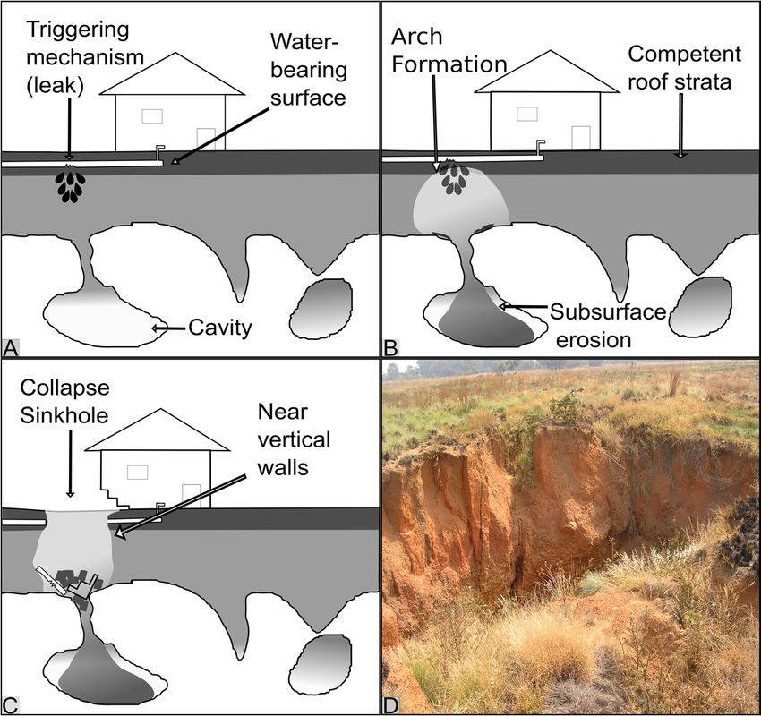
Remote Sens. 2018, 10, 1506                                                                                                           5 of 30

disaster managers and affected communities of impending sinkhole formation, thereby minimising
the potential for injuries and death.
Remote Sens. 2016, 8, x FOR PEER REVIEW                                                  5 of 30

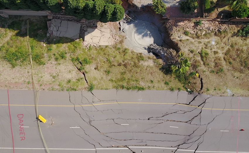
      Figure 3. AA sinkhole,
                   sinkhole,and
                              andassociated
                                   associated  tension
                                             tension    cracks,
                                                     cracks, thatthat resulted
                                                                  resulted      in road
                                                                           in road       closure
                                                                                    closure       in Gauteng,
                                                                                            in Gauteng,        South
                                                                                                         South Africa
      Africa
      in     in The
         2018.  2018.sinkhole
                       The sinkhole
                               is in is in process
                                      the  the process of being
                                                   of being       rehabilitated
                                                               rehabilitated  andandhas
                                                                                      hasbeen
                                                                                          beenfilled
                                                                                                filled with concrete.
                                                                                                            concrete.
      (photo credit: Dilnaaz Patel).

3. Statistical Modelling
3. Statistical Modelling and
                         and Probabilistic
                             Probabilistic Sinkhole
                                           Sinkhole Hazard
                                                    Hazard Assessment
                                                           Assessment
      It has been
      It has          noted that
              been noted       that valuable
                                      valuable indications
                                                   indications of    of an
                                                                        an area’s
                                                                            area’s vulnerability
                                                                                      vulnerability to    to sinkhole
                                                                                                              sinkhole andand subsidence
                                                                                                                                 subsidence
formation
formation can be obtained from knowledge of past events [12,13,15,31,37]. The process of sinkhole
              can   be   obtained     from    knowledge          of past   events     [12,13,15,31,37].        The   process     of  sinkhole
hazard
hazard mapmap generation
                 generation generally           involves the
                                 generally involves           the mapping
                                                                    mapping of   of the
                                                                                     the regional
                                                                                           regional parameters
                                                                                                       parameters that   that may
                                                                                                                                may impact
                                                                                                                                       impact
on  collapse    occurrences        [31]   and/or      the    analysis    of  the   spatial     distribution
on collapse occurrences [31] and/or the analysis of the spatial distribution of past sinkholes [15].             of  past   sinkholes     [15].
                                                                                                                                             A
A significant    component        in these   processes       involves    the   compilation       of a
significant component in these processes involves the compilation of a sinkhole inventory for an area sinkhole     inventory      for  an area
under
under investigation
         investigation and  and thethe subsequent
                                        subsequent analysisanalysis of of cause-and-effect
                                                                          cause-and-effect relationships
                                                                                                    relationships between
                                                                                                                        between sinkhole
                                                                                                                                     sinkhole
occurrences     and    local  conditions
occurrences and local conditions [11–14].     [11–14].
      Various
      Various approaches
                   approachestotothe     thecompilation
                                              compilation      of of
                                                                   sinkhole
                                                                      sinkhole  susceptibility
                                                                                    susceptibility  maps mapshavehavebeenbeen
                                                                                                                            described     [15].
                                                                                                                                   described
This
[15]. includes    (1) approaches
       This includes                   based on the
                            (1) approaches          based spatial
                                                               on distribution
                                                                     the spatial (density)
                                                                                       distributionof sinkholes,
                                                                                                          (density)(2)ofheuristic
                                                                                                                             sinkholes,models
                                                                                                                                            (2)
based    on  the  presence     of   particular    controlling       factors    and   (3)  probabilistic
heuristic models based on the presence of particular controlling factors and (3) probabilistic models         models     that  involves    the
analysis   of statistical
that involves              relationships
                    the analysis               betweenrelationships
                                       of statistical        existing sinkholes       and controlling
                                                                                between                      conditions.
                                                                                              existing sinkholes          andBoth    heuristic
                                                                                                                                 controlling
models
conditions.andBoth
                sinkhole      density
                        heuristic         approaches
                                     models     and sinkhole are geared
                                                                     densitytowards       the creation
                                                                                 approaches        are gearedof sinkhole
                                                                                                                   towardssusceptibility
                                                                                                                                the creation
maps    [15],  which     aid  in   defining    prevention         and   remediation
of sinkhole susceptibility maps [15], which aid in defining prevention and remediation     measures       [14].   In   this way, measures
                                                                                                                                    the most
hazardous
[14]. In thisareas
                way,can  the be  avoided
                              most            for further
                                       hazardous        areas development.
                                                                can be avoidedOn        forthe   other development.
                                                                                              further    hand, probabilistic  On the  models
                                                                                                                                         other
aims   to analyse     cause-and-effect       relationships        between      sinkhole
hand, probabilistic models aims to analyse cause-and-effect relationships between sinkhole  occurrences       and   local  conditions     [15],
thereby
occurrences and local conditions [15], thereby providing valuable information for the compilation to
           providing      valuable      information         for  the  compilation        of  sinkhole      risk  management          plans   of
reduce
sinkhole  dissolution     processes.
            risk management           plans to reduce dissolution processes.
      An    understanding of
      An understanding            ofthe
                                      thefactors
                                            factorscontrolling
                                                        controllingsinkhole
                                                                         sinkhole       development
                                                                                    development              is deemed
                                                                                                        is deemed            necessary
                                                                                                                         necessary         for
                                                                                                                                       for the
the  development         of  sinkhole      probability        models.      In   an  attempt
development of sinkhole probability models. In an attempt to develop sinkhole probability models  to  develop      sinkhole      probability
models    for Minnesota,
for Minnesota,       factors factors
                                such assuch       as distance
                                            distance               to nearest
                                                          to nearest     sinkhole,sinkhole,
                                                                                        sinkholesinkhole
                                                                                                     density, density,
                                                                                                                  bedrockbedrock
                                                                                                                              geology geology
                                                                                                                                          and
and   depth    to  bedrock      were    included       in   a decision     tree   model
depth to bedrock were included in a decision tree model [38]. However, the models did        [38].   However,        the  models      did not
                                                                                                                                           not
incorporate     controlling factors.
incorporate controlling          factors. In In contrast,
                                                 contrast, aa method
                                                                  method for  for assessing
                                                                                   assessing sinkhole
                                                                                                  sinkhole probability
                                                                                                                probability and  and hazard
                                                                                                                                       hazard
was
was tested
      tested for
               for the
                     the Ebro
                          Ebro Valley
                                   Valley in in Spain
                                                 Spain [37] [37] which
                                                                  which included
                                                                            included an    an assessment
                                                                                                assessment of    of the
                                                                                                                      the contribution
                                                                                                                           contribution of   of
specific
specific variables controlling sinkhole development and their effect on the predictive capability
           variables     controlling      sinkhole      development         and    their   effect    on  the   predictive     capability of  of
the
the models.
    models. The The results
                       results were
                                 were usedused toto define
                                                     define sinkhole
                                                                sinkhole susceptibility
                                                                             susceptibility modelsmodels for  for sinkhole
                                                                                                                  sinkhole hazard
                                                                                                                               hazard map map
generation
generation [37]. Further refinements to these models included the incorporation of magnitude and
               [37].   Further     refinements       to  these    models      included      the  incorporation         of magnitude       and
frequency
frequency relationships
              relationships to   to estimate
                                     estimate the the probability
                                                         probability of  of aa certain     area being
                                                                                certain area      being affected
                                                                                                           affected by  by aa sinkhole
                                                                                                                              sinkhole of of aa
specific
specific size
           size [39].    Further examples
                 [39]. Further       examples of    of sinkhole
                                                        sinkhole risk risk assessments
                                                                            assessments based   based onon sinkhole
                                                                                                              sinkhole inventories
                                                                                                                           inventories are are
available for several regions world-wide [12–15,17,37]. In general, statistical investigations reveal
that the probability of sinkhole development in undeveloped areas is statistically small when
measured as a percentage of the land area [13]. However, the anthropogenic activities in highly
developed, urbanised areas have accelerated the development of sinkholes [12,13,37]. In fact, in the
dolomitic terrain in the densely populated Gauteng Province of South Africa for example, statistical
The Role of Earth Observation, with a Focus on SAR Interferometry, for Sinkhole Hazard Assessment - MDPI
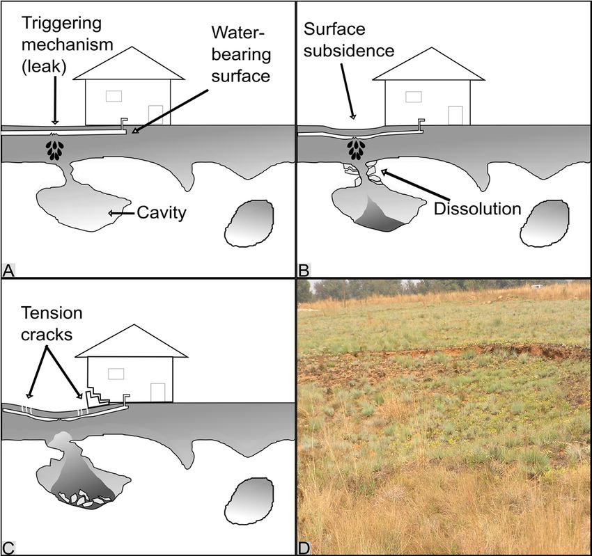
Remote Sens. 2018, 10, 1506                                                                         6 of 30

available for several regions world-wide [12–15,17,37]. In general, statistical investigations reveal that
the probability of sinkhole development in undeveloped areas is statistically small when measured
as a percentage of the land area [13]. However, the anthropogenic activities in highly developed,
urbanised areas have accelerated the development of sinkholes [12,13,37]. In fact, in the dolomitic
terrain in the densely populated Gauteng Province of South Africa for example, statistical analysis of
sinkhole inventories revealed that between 94 % and 99 % of sinkholes were triggered by anthropogenic
activities while only between 1% and 6% could be attributed to natural causes [13]. In particular, the
development density of these areas were found to be a significant factor leading to the conclusion that
higher densities of water bearing services were associated with higher likelihood of leaking services
and, therefore, higher probabilities of sinkhole development [13]. The investigation also revealed a
correlation between cumulative rainfall and sinkhole occurrences. It was concluded that an increase in
water ingress from ponding rainwater in areas not serviced by storm water drains led to an increase in
sinkhole events [13]. The information derived from sinkhole inventories have led to the development
of Dolomite Risk Management Strategies (DRMS) for the region. It was determined that, after the
development of the DRMS in 2004, the occurrence of sinkhole and subsidence events in the period
reduced from 50 events per year in the early 2000’s to 5 events per year, a reduction of 90% [13].
     It can be seen that effective sinkhole and subsidence hazard management strategies depend on a
comprehensive understanding of the geological mechanisms of sinkhole formation as well as the local
sinkhole characteristics, triggering and controlling factors. Section 4 will discuss the contribution from
earth observation towards collecting reliable and appropriate data for sinkhole hazard assessment,
with a focus on the compilation of sinkhole inventories and monitoring ground deformation associated
with sinkhole development.

4. The role of Earth Observation in Sinkhole Hazard Assessment
      Although in situ approaches for the collection of information for sinkhole hazard assessment
(including surveying, trenching, geophysical and geodetic monitoring approaches) are well established,
the limitations of these approaches are well described. This includes the fact that they are
time-consuming, labour intensive, costly and invasive [40–43]. Recent advances in earth observation
approaches, including satellite- and airborne imaging techniques, provide information that can
assist sinkhole hazard assessments. Earth observation technologies are used for compiling sinkhole
inventories but also have the potential to be more widely used for assessing sinkhole damage [44].
This includes the monitoring of active sinkholes [45] and even to identify environmental risk factors
that can contribute to sinkhole development. Remote sensing is often used to assess the extent and
magnitude of infrastructure damage using techniques involving high-resolution change detection on
optical or SAR imagery before and after the event [44]. It has successfully been used after disasters such
as earthquakes [44], volcanic eruptions [46] and landslides [47] and could therefore also be applied
to sinkhole events. Remote sensing can also be used to monitor the evolution of active sinkholes,
this requires very high-resolution data and airborne LiDAR has been shown to be an effective tool [45].
      In terms of sinkhole risk assessment and damage mitigation, it has been recognised that sinkholes
in urban areas are likely to be caused by anthropogenic factors with leaking water infrastructure and
groundwater extraction being particular risk factors [8,12,48,49]. There is therefore an opportunity to
investigate the role of remote sensing is assessing the presence of these risk factors and the relationship
with sinkhole formation. Remote sensing is in fact already widely used as a tool in monitoring
both leaking infrastructure and groundwater extraction. Pipe leaks can be detected by monitoring
vegetation growth using vegetation indices on high resolution optical data [50–52] while groundwater
extraction is often monitored using time-series SAR interferometry [53–55]. The potential therefore
exists to investigate the connection between these factors and sinkhole events using remote sensing.
      Although the monitoring of risk factors can be performed, the value derived from sinkhole
inventories through the reduction and management of sinkhole risk means that significant efforts have
been devoted to refining techniques for the compilation of sinkhole inventories using earth observation
The Role of Earth Observation, with a Focus on SAR Interferometry, for Sinkhole Hazard Assessment - MDPI
Remote Sens. 2018, 10, 1506                                                                                         7 of 30

     techniques. Additionally, new advances in earth observation techniques have also resulted in several
Remote Sens. 2016,
    attempts    to 8, x FOR PEER
                   identify      REVIEW
                            small-scale precursory deformations indicative of sinkhole development. The use7 of 30
     of earth observation techniques for the population of sinkhole inventories and for the detection of
world  (Figure 4).
    precursors      This includes
                to sinkhole  events the
                                     haveuse of conducted
                                           been optical, SARfor and   terrain
                                                                various        analysis
                                                                          regions  acrossapproaches     for sinkhole
                                                                                          the world (Figure   4).
inventory   compilation
    This includes the use ofas wellSAR
                            optical,   as and
                                           SAR    interferometry
                                              terrain                for monitoring
                                                      analysis approaches                 precursors
                                                                            for sinkhole inventory      to sinkhole
                                                                                                    compilation
development.   The interferometry
    as well as SAR   successes, advantages,      and limitations
                                      for monitoring   precursors toofsinkhole
                                                                        the various    approaches
                                                                                 development.   Theare    elaborated
                                                                                                      successes,
    advantages,   and limitations of  the various  approaches   are elaborated   on in Section
on in Sections 4.1 for sinkhole inventory compilation and Section 4.2 for precursor detection  4.1 for sinkhole
    inventory compilation and Section 4.2 for precursor detection respectively.
respectively.

      Figure   4. Earth
           Figure          observation
                    4. Earth            techniques
                              observation techniqueshave
                                                       have been used
                                                                  usedworldwide
                                                                         worldwide forfor sinkhole
                                                                                       sinkhole      precursor
                                                                                                 precursor       detection
                                                                                                             detection
           (stars) and   sinkhole  inventory compilation    using optical remote sensing   (blue triangles),
      (stars) and sinkhole inventory compilation using optical remote sensing (blue triangles), remotely     remotely
           generated
      generated         terrain
                   terrain      models
                             models    (greentriangles)
                                     (green    triangles) and
                                                          and DInSAR
                                                              DInSARtechniques
                                                                        techniques(red triangles).
                                                                                     (red triangles).
     4.1. Compilation of Sinkhole Inventories
4.1. Compilation of Sinkhole Inventories
           The most important step in sinkhole hazard assessment is the construction of a comprehensive
      The most
     sinkhole      important
                inventory     [11].step   in sinkhole
                                     In fact,  it has been hazard    assessment
                                                             noted that              is the
                                                                           the quality   andconstruction        of a comprehensive
                                                                                              accuracy of predictive      models
sinkhole   inventoryon
     are dependent        [11].
                             theIn    fact, it has been
                                  completeness               noted that the quality
                                                      and representativeness        of theand     accuracy
                                                                                             sinkhole          of predictive
                                                                                                          inventories  on which models
are dependent
     they are basedon the
                        [37].completeness
                               Theoretically, if  and    representativeness
                                                     a large  inventory of pastofsinkhole
                                                                                      the sinkhole
                                                                                               eventsinventories      on which they
                                                                                                         including information
     on  the  location,    magnitude       and    chronology     is available,   the   spatial  and
are based [37]. Theoretically, if a large inventory of past sinkhole events including information     temporal    probability   of on
the sinkholes
     location, can    be derived and
                  magnitude          [39]. Sinkhole
                                            chronology  inventories   should, ideally,
                                                               is available,             includeand
                                                                                the spatial        information
                                                                                                          temporalon the location, of
                                                                                                                      probability
     morphometric      parameters,      genetic    type,  chronology,   deformation     activity,
sinkholes can be derived [39]. Sinkhole inventories should, ideally, include information on the    conditioning   and  triggering
     factors of past sinkhole events [11]. The compilation of sinkhole inventories are usually achieved
location, morphometric parameters, genetic type, chronology, deformation activity, conditioning
     using direct observations such as interviews with local residents and geophysical investigations [15]
and triggering factors of past sinkhole events [11]. The compilation of sinkhole inventories are
     (Section 3). However, in recent years, various remote sensing approaches have also proven to be
usually   achieved using direct observations such as interviews with local residents and geophysical
     effective in the identification of sinkholes at the surface, typically through analysis of historical aerial
investigations
     photographs,  [15]   (Section
                      satellite imagery3). However,        in recent
                                             and topographic       mapsyears,    various remote
                                                                          [12,15,17,18,22,27].           sensing approaches
                                                                                                  The compilation     of sinkholehave
also inventories
     proven to be      effective
                   generally         in the
                                relies        identification
                                         on two     aspects: (1) of
                                                                  thesinkholes
                                                                       detection ofat buried
                                                                                       the surface,
                                                                                               cavities typically
                                                                                                          that maythrough     analysis
                                                                                                                    cause future
of historical    aerial    photographs,         satellite   imagery      and   topographic
     collapse of the surface and (2) an inventory of sinkholes that formed in the past.           maps      [12,15,17,18,22,27].    The
compilation      of detection
           For the   sinkholeand   inventories
                                       mapping ofgenerally          relies on
                                                        buried sinkholes     andtwo     aspects:
                                                                                  cavities,          (1) the
                                                                                            geophysical         detection
                                                                                                             methods   haveof   buried
                                                                                                                             been
     used   with  reasonable     success     [25,26].    These   methods    can  be  either  destructive
cavities that may cause future collapse of the surface and (2) an inventory of sinkholes that formed in      or non-destructive.
     Destructive methods include drilling and trenching and are useful for in-depth characterisation
the past.
     of thethe
      For    structures
                 detection andand
                                dating     of sediments;
                                       mapping                information
                                                      of buried     sinkholes not and
                                                                                  obtainable     through
                                                                                         cavities,           other methods
                                                                                                      geophysical     methods [56].have
     They are, however, only successful if the excavation site is well chosen, typically by non-destructive
been used with reasonable success [25,26]. These methods can be either destructive or
     methods [22,56]. Non-destructive geophysical methods include the use of seismic reflection [30],
non-destructive. Destructive methods include drilling and trenching and are useful for in-depth
     micro-gravity surveys [4,27], magnetic surveys [57] electromagnetic (EM) surveys [30,56,58] and
characterisation     of the structures and dating of sediments; information not obtainable through other
     ground penetrating radar (GPR) [25,56]. A review of the geophysical methods for the detection of
methods     [56]. They
     underground           are, however,
                       cavities                  only successful
                                 has been completed            [57]. Inifgeneral,
                                                                          the excavation
                                                                                   the most site     is well used
                                                                                                commonly       chosen,   typically by
                                                                                                                    geophysical
non-destructive
     technique for methods
                      the detection [22,56].    Non-destructive
                                        of underground       cavities isgeophysical      methods
                                                                          GPR which operate            include themicrowaves
                                                                                                  by transmitting     use of seismic
reflection   [30],  micro-gravity         surveys      [4,27],   magnetic     surveys     [57]   electromagnetic
     into the ground and analysing the returned signal [25,26]. The technique has been used to identify                (EM) andsurveys
[30,56,58] and ground penetrating radar (GPR) [25,56]. A review of the geophysical methods for the
detection of underground cavities has been completed [57]. In general, the most commonly used
geophysical technique for the detection of underground cavities is GPR which operate by
transmitting microwaves into the ground and analysing the returned signal [25,26]. The technique
The Role of Earth Observation, with a Focus on SAR Interferometry, for Sinkhole Hazard Assessment - MDPI
Remote Sens. 2018, 10, 1506                                                                                                                 8 of 30

localise subsurface cavities [26] and has also successfully identified buried sinkholes [25] to contribute
to sinkhole inventories. An example of a radargram generated for a sinkhole-prone area in South
Africa is presented in Figure 5. Anomalous features identified were associated with a zone of increased
Remote Sens. 2016, 8, x FOR PEER REVIEW                                                                  8 of 30
reflections due to the presence of a water-filled zone [59]. The value of GPR depends on the subsurface
material
value of characteristics
           GPR depends on      as well  as operatormaterial
                                  the subsurface     expertise and knowledge
                                                            characteristics     of the
                                                                            as well    area and expertise
                                                                                    as operator is limitedand
                                                                                                            by
penetration
knowledge of   depth    of theand
                  the area     selected  frequency
                                  is limited        [22].
                                             by penetration  depth of the selected frequency [22].

       Figure 5.
       Figure  5. Radargram
                  Radargram indicating
                             indicating aa potential
                                           potential water-filled
                                                     water-filled feature
                                                                  feature beneath
                                                                          beneath aa car-park
                                                                                     car-park in
                                                                                              in South
                                                                                                 South Africa
                                                                                                       Africa
       (with permission
       (with permission from
                         from [59]).
                               [59]).

      Gravity
       Gravitysurveys
                   surveyshave  have  also
                                         alsobeen    performed
                                                  been    performed for thefordetection
                                                                                the detectionof buriedof cavities.      In fact, the
                                                                                                         buried cavities.            Inapproach
                                                                                                                                         fact, the
was   demonstrated
 approach                  to be effective
              was demonstrated             to beineffective
                                                      the DeadinSea   theregion
                                                                            Dead Sea when      sinkholes
                                                                                           region    whenoccurred
                                                                                                              sinkholesa occurred
                                                                                                                                few months    a fewto
amonths
   few years
           to a after    the survey
                  few years      after therevealed
                                               surveythe       presence
                                                           revealed     theof   anomalies
                                                                             presence            [27]. When
                                                                                            of anomalies      [27].usingWhen gravity
                                                                                                                                  usingsurveys,
                                                                                                                                           gravity
areas  prone
 surveys,       to collapse
             areas      prone are  to generally
                                        collapse associated
                                                       are generally with negative
                                                                              associated  gravity
                                                                                                withanomalies,
                                                                                                        negative highlighting             shallow
                                                                                                                         gravity anomalies,
mass    deficits shallow
 highlighting      and the potential
                                mass deficits  for subsidence        or collapse
                                                      and the potential          for [4].    EM surveys,
                                                                                       subsidence               including
                                                                                                        or collapse         [4]. the
                                                                                                                                   EMTransient
                                                                                                                                         surveys,
Electromagnetic        Method Electromagnetic
 including the Transient            (TEM) and the Electrical   Method Resistivity
                                                                          (TEM) andTomography
                                                                                            the Electrical   (ERT)      methods,
                                                                                                               Resistivity            have been
                                                                                                                                   Tomography
also
 (ERT)used   to provide
         methods,       have a better
                                 been understanding
                                           also used to provide  of the composition          of underground
                                                                             a better understanding                ofdeposits       by profiling
                                                                                                                        the composition            of
different
 undergroundresistivity
                    depositszones      [30]. In this
                                 by profiling             way, different
                                                      different   resistivity  resistivities
                                                                                  zones [30].could In thisbeway,
                                                                                                               an indications          of buried
                                                                                                                      different resistivities
sinkholes
 could be an  and    air- or water-filled
                 indications                        cavities [58].
                                  of buried sinkholes                  In one
                                                                and air-         investigation,
                                                                             or water-filled           ERT was
                                                                                                   cavities   [58]. successfully          used to
                                                                                                                       In one investigation,
characterise     buried sinkholes
 ERT was successfully           used toby         identifyingburied
                                             characterise         the low     resistivity
                                                                          sinkholes       by of   the clayeythe
                                                                                               identifying        filllow
                                                                                                                        material     whichofwas
                                                                                                                             resistivity          the
contrasted     against gravelly
 clayey fill material       which was    alluvium
                                              contrastedsurrounding         the cavity
                                                               against gravelly             [56]. An
                                                                                       alluvium         example ofthe
                                                                                                     surrounding            ERT     data[56].
                                                                                                                                cavity      for the
                                                                                                                                                  An
detection
 example of subsurface
                 ERT data anomalies
                                 for the detection are provided     in Figure 6.
                                                             of subsurface            In this example
                                                                                  anomalies                 from South
                                                                                                   are provided                Africa,6.a In
                                                                                                                         in Figure           highly
                                                                                                                                                 this
resistive
 examplezonefromwas  Southidentified
                              Africa, and       inferred
                                         a highly           to be associated
                                                       resistive                   with an air-filled
                                                                    zone was identified                     cavity to
                                                                                                  and inferred        [58,59].     Additionally,
                                                                                                                           be associated        with
more    conductive
 an air-filled           zones
                    cavity         associated
                               [58,59].              with weathered
                                             Additionally,         more dolomitic
                                                                             conductivematerial zones filling
                                                                                                         associated two known          sinkholes
                                                                                                                            with weathered
were   observed
 dolomitic           [58,59].
              material          Although
                            filling    two known these examples
                                                           sinkholesillustrate       that ERT[58,59].
                                                                         were observed             has beenAlthough
                                                                                                               found to these  be successful
                                                                                                                                        examples   in
mapping
 illustrate buried
             that ERT  cavities,
                           has been the found
                                          limitation to beis successful
                                                              that the technique
                                                                            in mapping  reliesburied
                                                                                                 on fillcavities,
                                                                                                         materialsthe     having     contrasting
                                                                                                                             limitation      is that
resistivities
 the technique   when
                    reliescompared          to surrounding
                             on fill materials                      materials.resistivities
                                                       having contrasting            Furthermore,    when ERT      is limited
                                                                                                             compared               by a loss of
                                                                                                                               to surrounding
resolution    at depth [56]. ERT is limited by a loss of resolution at depth [56].
 materials. Furthermore,
      In addition
           addition to  to the
                            the loss
                                  loss ofof resolution
                                              resolution and   and the
                                                                     the depth
                                                                           depth of  of the
                                                                                         the investigation,
                                                                                               investigation, generalgeneral limitations
                                                                                                                                  limitations of   of
geophysical
 geophysical surveys is related to the fact that the                the absence
                                                                          absence of aa cavitycavity inin the
                                                                                                           the geophysics
                                                                                                                 geophysics results results does
                                                                                                                                               does
not
 not necessarily
      necessarily reject
                       reject the
                                the possibility
                                       possibility of   of future
                                                             future collapse
                                                                       collapse [27].
                                                                                    [27]. Furthermore,
                                                                                            Furthermore, although effective over                over
small
 small areas,
         areas, terrestrial geophysical surveys cannot be applied to extensive areas since it is                                            is both
                                                                                                                                                both
time-consuming
 time-consuming and     and expensive
                                expensive[27]     [27]and
                                                        and areare   considered
                                                                 considered       to beto hazardous
                                                                                           be hazardous          in potentially
                                                                                                         in potentially          unstableunstable
                                                                                                                                               areas
areas   [27]. Therefore,
 [27]. Therefore,                earth observation
                      earth observation            technologiestechnologies        are increasingly
                                                                     are increasingly                        being considered
                                                                                              being considered                             for the
                                                                                                                         for the compilation
compilation       of sinkhole since
 of sinkhole inventories             inventories
                                              the data  since
                                                            canthe     datalarge
                                                                   cover      can cover
                                                                                      areas large
                                                                                               rapidly,areascostrapidly,
                                                                                                                    effectivelycost and
                                                                                                                                      effectively
                                                                                                                                              safely
and   safely [44,60,61].
 [44,60,61].
      Various
       Variousremoteremotesensing
                                sensing  platforms
                                               platformsare used
                                                               are for
                                                                     used sinkhole     inventories,
                                                                              for sinkhole              each witheach
                                                                                                   inventories,          its own withadvantages
                                                                                                                                          its own
and   disadvantages.
 advantages                   Ground-based
                 and disadvantages.                   systems such
                                                  Ground-based             as ground-based
                                                                        systems                      radar and portable
                                                                                     such as ground-based                radar and   LiDAR
                                                                                                                                         portableare
 LiDAR are
typically      typically cost-effective
            cost-effective       and offer good     and resolution;
                                                         offer good resolution;
                                                                         however, they    however,
                                                                                                 do notthey
                                                                                                         cover dolarge
                                                                                                                     not cover
                                                                                                                             areas,large      areas,
                                                                                                                                       can easily
 canobstructed
be    easily be obstructed           and it is challenging
                    and it is challenging             to keep thetosensor keep stable
                                                                                  the sensorover stable      over long
                                                                                                    long periods               periods
                                                                                                                          [26,45].         [26,45].
                                                                                                                                      Optical      or
 Optical or LiDAR sensors flown on airborne platforms are well suited for sinkhole investigations
LiDAR     sensors     flown     on   airborne       platforms     are   well   suited     for   sinkhole    investigations          due    to  their
 due to
high      their high[62,63].
       resolution         resolution      [62,63]. data
                                      However,         However,        data acquisition
                                                               acquisition      campaignscampaignsare relativelyare relatively
                                                                                                                         expensiveexpensive
                                                                                                                                         and are
 and are typically not done frequently over long periods. In these instances, spaceborne platforms are
 ideal for monitoring large areas consistently over time, and are frequently used to investigate
 sinkholes [46,61]. However, spatial resolution is a significant challenge for sinkhole research from
 spaceborne systems due to their relatively small scale [20].
The Role of Earth Observation, with a Focus on SAR Interferometry, for Sinkhole Hazard Assessment - MDPI
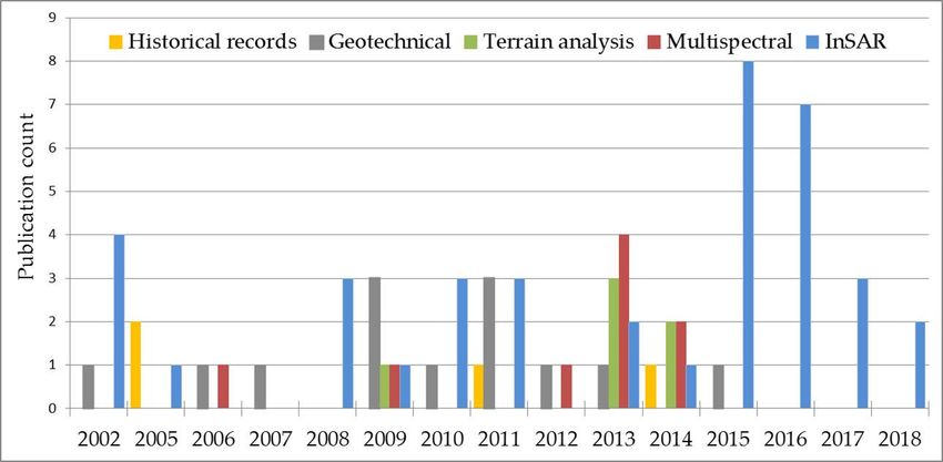
Remote Sens. 2018, 10, 1506                                                                                          9 of 30

typically not done frequently over long periods. In these instances, spaceborne platforms are ideal for
monitoring large areas consistently over time, and are frequently used to investigate sinkholes [46,61].
However, spatial resolution is a significant challenge for sinkhole research from spaceborne systems
due to their relatively small scale [20].
Remote Sens. 2016, 8, x FOR PEER REVIEW                                                                               9 of 30

                                                            (A)

                                                            (B)
      Figure 6.
      Figure 6. (A)
                (A) The
                    The process
                         processof
                                 ofERT
                                    ERTdata
                                         datacollection;
                                              collection;and
                                                          and(B)
                                                               (B)Sample
                                                                   Sample  ERT
                                                                         ERT    profile
                                                                              profile   indicating
                                                                                      indicating thethe presence
                                                                                                     presence of
      of anomalies
      anomalies     including
                 including    a potential
                           a potential    cavity
                                       cavity andand  know
                                                   know      surface
                                                          surface     cavings
                                                                   cavings    (with
                                                                           (with    permission
                                                                                 permission      from
                                                                                              from     [59]).
                                                                                                   [59]).

      Sinkholes
       Sinkholes are typically
                        typically characterised
                                     characterised by circular or oval shapes,    shapes, conical collapse structures,
concentric
concentric cracks along the outer edges,   edges, a sharp
                                                      sharp drop
                                                              drop inin elevation
                                                                          elevation or or basin-like
                                                                                          basin-like depressions
                                                                                                       depressions on on the
                                                                                                                         the
surface
surface [64].
           [64].The
                  Themapping
                       mapping   of sinkholes   usingusing
                                     of sinkholes      remote    sensing
                                                              remote        techniques
                                                                         sensing          generally
                                                                                    techniques       rely on the
                                                                                                  generally       detection
                                                                                                               rely  on the
and   mapping
detection     andof mapping
                    these distinct    geomorphological
                                 of these                    features using one
                                              distinct geomorphological               of two using
                                                                                  features    broad approaches
                                                                                                      one of twonamely;
                                                                                                                      broad
(1) feature  extraction  on  optical   imagery   and  (2) terrain  models     that are  analysed
approaches namely; (1) feature extraction on optical imagery and (2) terrain models that are      for depression   features.
The  simplest
analysed     formethod    of feature
                 depression             detection
                                features.          on optical
                                            The simplest        imagery
                                                              method     ofisfeature
                                                                               visual inspection
                                                                                       detection onof aerial photography
                                                                                                       optical  imagery is
for  signs
visual       of sinkholes
          inspection        [65]. photography
                       of aerial    This technique   forcan   be very
                                                          signs          valuable[65].
                                                                  of sinkholes        as sinkholes    can often
                                                                                           This technique     canbebedated
                                                                                                                        very
accurately    since many   countries     have  aerial  photograph     archives     dating  back
valuable as sinkholes can often be dated accurately since many countries have aerial photograph  several  decades    [22,33].
Sinkhole
archives depressions
             dating back can      oftendecades
                             several      be identified
                                                   [22,33].bySinkhole
                                                               pondingdepressions
                                                                             of water, concentric
                                                                                            can oftengeomorphological
                                                                                                         be identified by
structures
ponding ofsuch      as tension
                water,            cracks
                         concentric        or vegetation clumps
                                        geomorphological               [66,67]such
                                                                structures       whichas are  visible
                                                                                          tension      on remote
                                                                                                    cracks         sensing
                                                                                                            or vegetation
scenes.
clumpsIn[66,67]
             general,  for remote
                     which            sensingon
                               are visible      investigations,
                                                   remote sensing  high resolution,
                                                                           scenes. In sharpness      and remote
                                                                                          general, for    the ability  to be
                                                                                                                    sensing
viewed    stereoscopically
investigations,              is important
                   high resolution,          considerations
                                         sharpness   and the when
                                                                abilityselecting   scenesstereoscopically
                                                                         to be viewed      for identifying sinkholes    [22].
                                                                                                              is important
In  an  investigation   in Spain,   all  but one  of the   sinkholes    found    in a comprehensive
considerations when selecting scenes for identifying sinkholes [22]. In an investigation in Spain, all   inventory    could
be
butdetected
     one of theusing  aerial imagery.
                  sinkholes   found in It    was concluded that
                                          a comprehensive            historical
                                                                inventory          imagery
                                                                               could          can beusing
                                                                                      be detected     extremely
                                                                                                           aerial useful
                                                                                                                  imagery.to
It was concluded that historical imagery can be extremely useful to detect sinkholes in areas where
anthropogenic landscape transformation would later erase surface expression of their presence [22].
       The construction of sinkhole inventories using remote sensing data is frequently difficult due to
complications in identifying sinkhole-related geomorphic features if high resolution data at high
temporal frequency is unavailable. Specifically, in several cases, erosion, sedimentation and
anthropogenic fills may also mask sinkhole-related geomorphic features soon after they have
The Role of Earth Observation, with a Focus on SAR Interferometry, for Sinkhole Hazard Assessment - MDPI
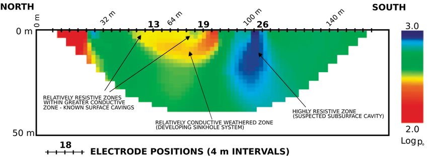
Remote Sens. 2018, 10, 1506                                                                         10 of 30

detect sinkholes in areas where anthropogenic landscape transformation would later erase surface
expression of their presence [22].
      The construction of sinkhole inventories using remote sensing data is frequently difficult
due to complications in identifying sinkhole-related geomorphic features if high resolution data
at high temporal frequency is unavailable. Specifically, in several cases, erosion, sedimentation
and anthropogenic fills may also mask sinkhole-related geomorphic features soon after they have
formed. Such transformation is a big challenge for detecting sinkholes using visual clues only [22,31].
To overcome the limitation of relying only on visible geomorphic expressions, recent experiments have
focused on using infrared data to identify temperature differentials between sinkhole-related features
and the surrounding landscape. Using drone-based infra-red sensing, this technique relies on sinkhole
depressions being colder at night than the surrounding environment and thereby providing a good
dataset for machine learning classifiers [68]. Extensive validation and verification of these approaches
remains to be performed.
      The use of terrain models to extract the characteristic geomorphic expressions associated with
sinkholes has also been investigated. Terrain models can be generated from many sources with the simplest
being topographic maps generated by surveying techniques. Remote sensing techniques to generate
terrain models include terrestrial airborne laser scanning [45,62,69], stereo-photogrammetry using optical
imagery [70], drone-based Structure from Motion (SfM) [71] and SAR interferometry [72,73] among
others. Global elevation models such as the SRTM and ASTER GDEM, generated through spaceborne
SAR interferometry or stereo-photogrammetry respectively, are freely available. However, their use
for sinkhole inventories is limited due to their spatial resolution (~30 m) and absolute vertical height
accuracy (>16 m) [74] being lower than typical sinkhole feature dimensions. Sinkhole inventories are
therefore typically built using airborne platforms. It should be noted that the higher spatial resolution
(12 m) and absolute vertical accuracy (6 m) of the recently released WorldDEM [75] may be suitable for
the compilation of sinkhole inventories, especially for large sinkhole events, for example in the cases
where widths exceeding 100 m and depths exceeding 30 m have been reported [4,76]. Studies have
found that high quality topographic maps generated using stereogrammetry on orthophotos can be
used to detect and delineate surface depressions likely to be related to sinkholes [22]. However, it was
found that the technique relies on sinkhole being large enough to map using these depending on the
resolution of the data. The limitation of airborne surveys is that the acquisition of high resolution
data over extended areas at high temporal frequency is costly. To overcome this limitation UAV-based
image acquisition has evolved to be a simple and cost effective alternative. This data can be used in
combination with a three-dimensional image stitching technique called Structure from Motion (SfM),
similar in concept to stereogrammetry, to extract terrain models [71]. SfM allows for quick and cost
effective generation of 3D point clouds over small areas at a fraction of the cost of airborne surveys [63].
In general, SfM models provide vertical accuracy in the cm to metre scale, with reported RMSE’s
ranging between 0.1 m and 1 m [71]. These accuracies have been found to be accurate enough to map
surface topography and to detect all but the smallest sinkhole depressions [71]. Rapid advances are
being made in commercial UAV technology and processing algorithms and SfM is expected to become
a valuable tool for rapid surface model generation at a low cost [63].
      Airborne laser scanning is also commonly used for the extraction of accurate terrain models
and several investigations used these models for the mapping of sinkhole-related geomorphological
features [33,45,62,64]. Airborne laser scanning has been used for the detection of geomorphic features
associated with land degradation and sinkhole events in the Dead Sea region [64]. Data analysis
focused on identifying areas characterised by a sharp drop in the surface topography in addition to
features of circular to oval shapes. Furthermore, sinkholes in the area were associated with conical
collapse structures and concentric cracks outside of the edges. The laser scanning data was noted
for its ability to detect the cracks at an early stage, pointing to the potential of laser scanning data
being used for early warning of impending sinkhole formation [64]. However, challenges in the use
of airborne laser scanning for the compilation of sinkhole inventories have also been identified [33].
Remote Sens. 2018, 10, 1506                                                                         11 of 30

The problems include: (1) the under-estimation of the area of the depressions depending on the
resolution of the data and the size and depth of the depression, (2) the presence of vegetation that
can mask the sinkhole boundaries leading to underestimation of sinkhole extents depending on the
vegetation density, (3) in urban areas the presence of buildings and structures mask the presence of
depressions, and (4) the inability to distinguish between man-made depressions and sinkholes [33].
      Irrespective of the choice of data, the visual inspections of imagery or terrain models in
an effort to identify sinkholes are time consuming, labour intensive and highly dependent on
operator expertise which may lead to incomplete, unreproducible or biased results [63,65,71,77,78].
Automated feature extraction algorithms can therefore play a critical role in sinkhole inventory
collection. Various techniques, drawn from a wide range of fields, have been used for automated feature
extraction from surface models. In general, pixel-based techniques have been found to be inappropriate
for successful feature extraction and most research is focussed on object-, rule- or case-based
analysis and artificial neural networks [77]. Terrain analysis-based techniques include sink-filling,
whereby a depression-less model is subtracted from the original model to locate depressions, and active
contour and image filtering approaches [65]. Spatial models, based on parameters estimated for the
feature of interest, can also be used to find matching patterns to expected features in the data [21].
Transformations used in computer vision, such as the Hough transform with its ability to extract
ellipses, is also very useful on contour data [79]. Other techniques drawing on graph theory are
also useful, particularly for their ability to work on sparse graphs since surface models are often not
complete continuous datasets due to noise and artefacts [65,80].
      Although the earth observation approaches can identify historical sinkhole events based on
the topographic expression or visual clues, their use is limited in areas where natural processes
(like erosion and sedimentation) or anthropogenic activities mask the normal topographic expression
of these events [22,31]. Furthermore, mapping sinkholes are very dependent on the specific local
geology and land cover as all techniques are not equally effective in different areas. The process of
sinkhole inventory creation in general have been described as arduous with complications due to
(1) complications in identifying sinkhole morphology in flat areas, (2) the obliteration of sinkhole
features due to anthropogenic fills, and (3) the non-disclosure of sinkhole events by land owners due
to the fear of depreciation of the value of their property [39].
      Ultimately, the mitigation of sinkhole risks based on susceptibility mapping and sinkhole
management plans derived from probabilistic models depends on the reliability of the predictive
models on which they are based [15]. Although significant reductions in the number of occurrences of
sinkholes have been observed based on risk management plans derived from sinkhole inventories [13],
the reliability of the predictive capability remains unknown in a large number of instances [15]. For this
reason, several investigations have been devoted to the search of small scale vertical movements that
may be indicative of impending sinkhole collapse. The detection of small scale precursors to sinkhole
formation may contribute to the provision of sinkhole early warning, therefore further minimising the
probability of catastrophic events. The detection of vertical movement of the surface is measureable,
in ideal conditions, by geodetic or remote sensing techniques as outlined in Section 4.2.

4.2. Detecting Precursors to Sinkhole Development
      Due to the risks involved with invasive and non-invasive cavity detection approaches, a significant
amount of research has focused on the development of techniques to detect and monitor deformation
prior to sinkhole development. The ability to detect ground deformation indicative of impending
failure allows for proactive remediation, increasing public safety and minimising infrastructural
damage [21]. The presence of deformation preceding the collapse of rock masses have been known to
exist and are used as early warning for rock mass failures [24]. This is particularly relevant in the mining
industry where precursory deformation is observed in both surface and underground mines [35,81].
In the case of sinkholes, deformation in the order of a few mm to cm are speculated to be present
days, months or even years before the failure [19,20,26]. In general, measurable deformation have been
You can also read