Terminal 30 Substation Replacement Project - Port of Seattle SEPA File # 2021-08 ENVIRONMENTAL CHECKLIST
←
→
Page content transcription
If your browser does not render page correctly, please read the page content below
ENVIRONMENTAL CHECKLIST

                                               for the

Terminal 30 Substation
  Replacement Project
          Port of Seattle SEPA File # 2021-08

                                        prepared for

                                   Port of Seattle

                                        October 2021

    EA Engineering, Science, and Technology, Inc., PBC
PREFACE
The purpose of this Environmental Checklist is to identify and evaluate probable environmental
impacts that could result from the Terminal 30 (T-30) Substation Replacement Project and to
identify measures to mitigate those impacts.
On November 29, 2020, the T-30 Central Substation failed and caused a power outage to a
substantial portion of the terminal. Rental diesel generators were connected to provideemergency
power. A temporary substation was subsequently installed to replace the diesel generators and
supply power to T-30 uses until a permanent replacement substation can be constructed and
connected. The proposed Permanent Substation is the subject of this SEPA Checklist.
1
The State Environmental Policy Act (SEPA) requires that all governmental agencies consider the
environmental impacts of a proposal before the proposal is decided upon. This Environmental
Checklist has been prepared in compliance with the SEPA Rules, effective April 4, 1984, as
amended (Chapter 197-11), Washington Administrative Code; and Port of Seattle SEPA
Resolution No. 3650.
This document is intended to serve as SEPA review for site preparation work, demolition,
construction, and operation of the proposed T-30 Substation Replacement Project. Analysis
associated with the proposed project contained in this Environmental Checklist is based on plans
for the project, which are on-file with the Port of Seattle. While not construction-level in detail, the
schematic plans accurately represent the eventual size, location and configuration of
improvements and are considered adequate for analysis and disclosure of environmental impacts.
This Environmental Checklist is organized into three major sections. Section A of the Checklist
(starting on page 1) provides background information concerning the Proposed Action (e.g.,
purpose, proponent/contact person, project description, project location, etc.). Section B
(beginning on page 9) contains the analysis of environmental impacts that could result from
implementation of the proposed project, based on review of major environmental parameters.
This section also identifies possible mitigation measures. Section C (page 27) contains the
signature of the proponent, confirming the completeness of this Environmental Checklist.
Relevant project analyses that served as a basis for this Environmental Checklist include: the
Greenhouse Gas Emissions Worksheet (EA, 2021). This report is on-file at the Port of Seattle and
is included as an appendix to this SEPA Checklist.
1 Chapter 43.21C. RCWTABLE of CONTENTS
Page
PURPOSE ..........................................................................................................................................1
A. BACKGROUND .........................................................................................................................1
1. Name of Proposed Project: .................................................................................................. 1
2. Name of Applicant: ............................................................................................................... 1
3. Contac Information ............................................................................................................... 1
4. Date Checklist Prepared ...................................................................................................... 1
5. Agency Requesting Checklist............................................................................................... 1
6. Proposed Schedule .............................................................................................................. 1
7. Plans for Future Additions .................................................................................................... 1
8. Environmental Information ................................................................................................... 2
9. Pending Applications or Approvals ...................................................................................... 2
10. Government Approvals or Permits ....................................................................................... 2
Local Agencies ................................................................................................................... 2
11. Proposal Description ............................................................................................................ 2
Existing Conditions............................................................................................................. 2
Proposal .............................................................................................................................3
12. Location of the Proposal ...................................................................................................... 8
B. ENVIRONMENTAL ELEMENTS ............................................................................................... 9
1. Earth .....................................................................................................................................9
2. Air .......................................................................................................................................10
3. Water ..................................................................................................................................11
4. Plants .................................................................................................................................13
5. Animals ..............................................................................................................................14
6. Energy and Natural Resources .......................................................................................... 15
7. Environmental Health ......................................................................................................... 15
8. Land and Shoreline Use ..................................................................................................... 18
9. Housing ..............................................................................................................................20
10. Aesthetics ...........................................................................................................................21
11. Light and Glare ................................................................................................................... 22
12. Recreation ..........................................................................................................................23
13. Historic and Cultural Preservation ...................................................................................... 23
14. Transportation ....................................................................................................................25
15. Public Services ................................................................................................................... 26
16. Utilities ................................................................................................................................26
C. SIGNATURES..........................................................................................................................27
Appendices
A. Greenhouse Gas Emissions Worksheet
Environmental Checklist i
Terminal 30 Substation Replacement ProjectLIST of FIGURES Figure Page 1. Aerial Vicinity Map................................................................................................................... 4 2. Existing Site Conditions .......................................................................................................... 5 3. Electrical Phasing Plan ........................................................................................................... 6 4. Site Plan .................................................................................................................................. 7 Environmental Checklist ii Terminal 30 Substation Replacement Project
PURPOSE
The State Environmental Policy Act (SEPA), Chapter 43.21 RCW, requires all governmental
agencies to consider the environmental impacts of a proposal before making decisions. The
purpose of this checklist is to provide information to help identify impacts from the proposal (and
to reduce or avoid impacts, if possible) and to help the Port of Seattle to make a SEPA threshold
determination.

A.     BACKGROUND
1. Name of Proposed Project:

       Terminal 30 Substation Replacement Project (Port of Seattle SEPA File # 2021-08)

2. Name of Applicant:

       Port of Seattle

3. Address and Phone Number of Applicant and Contact Person:

       Danielle Butsick, Senior Environmental Management Specialist, Maritime Environment
       and Sustainability
       Port of Seattle
       P.O. Box 1209
       Seattle, WA 98111
       206-549-2945
       butsick@portseattle.org

4. Date Checklist Prepared

       October 15, 2021

5. Agency Requesting Checklist

       Port of Seattle (the Port)
6. Proposed Timing or Schedule (including phasing, if applicable):

       The Terminal 30 (T-30) Substation Replacement Project analyzed in this
       Environmental Checklist involves site preparation work, demolition, construction and
       operation. Site preparation and construction is expected to begin in Autumn 2022 with
       build-out and operation by Spring 2023.
7. Do you have any plans for future additions, expansion, or furtheractivity
   related to or connected with this proposal? If yes, explain.

       No other specific development is planned for the T-30 Substation Replacement Project
       site at this time.

Environmental Checklist                                                                         1
Terminal 30 Substation Replacement Project
8. List any environmental information you know about that has been
prepared, or will be prepared, directly related to this proposal:
Past information used to prepare this SEPA Checklist include:
Declaration of Emergency; Emergency Repair Due to T-30 Electrical Equipment
Failure Memo, Northwest Seaport Alliance, December 8, 2020.
Studies prepared specifically for this SEPA Checklist include:
Greenhouse Gas Emissions Worksheet (EA 2021).
9. Do you know whether applications are pending for governmental
approvals of other proposals directly affecting the property covered by
your proposal? If yes, explain:
There are no other applications that are pending approval for the T-30 Substation
Replacement Project.
10. List any government approvals or permits that will be needed for your
proposal, if known:
The following approvals or permits are anticipated to be required for proposed substation
replacement at T-30.
Local Agencies
City of Seattle
Department of Construction and Inspections -- permits/approvals associated
with the proposed project, including:
Demolition Permits
Construction Permits
Mechanical Permits
Electrical Permits
11. Give a brief, complete description of your proposal, including the
proposed uses and the size of the project and site. There are several
questions later in this checklist that ask you to describecertain aspects
of your proposal. You do not need to repeat those answers on this page.
Existing Conditions
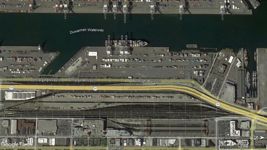
Port of Seattle T-30 is located at 1901 East Marginal Way South in the city of Seattle,
along the eastern edge of the East Duwamish Waterway. The T-30 Substation
Replacement site is located on the eastern edge of T-30 immediately west of East
Marginal Way South (see Figure 1 and Figure 2).
The Port of Seattle T-30 has been in service as a marine cargo terminal since the Port
Environmental Checklist 2
Terminal 30 Substation Replacement Projectpurchased the property in 1985, with the exception of the years between 2003 and 2008
when it operated as a cruise terminal. The upland Port-owned portion of the site consists
of approximately 38 acres of marine cargo marshaling area, warehouse structures, repair
and maintenance buildings, and operations facilities. It also contains a Port Police station
and waterfront office.
The T-30 Central Substation connects with the Seattle City Light (SCL) electric grid and
distributed electric power to T-30 uses. On November 29, 2020, the T-30 Central
Substation failed and caused a power outage to a substantial portion of T-30, including:
refrigerated containers, T-28 M & R shop, Port of Seattle police station, guard shack, yard
lighting, and, other miscellaneous infrastructure. A subsequent inspection of the failed
substation on November 30, 2020 found extensive equipment damage and general repairs
were determined not to be feasible. Rental diesel generators were provided, connected
and power was restored to T-30 uses on December 1, 2020.
A temporary substation, including enclosed electrical switch, was installed adjacent to the
existing failed Central Substation to replace the diesel generators. The Temporary
Substation, which connects to the Seattle City Light electrical grid, was connected in May
2021 and isintended to supply power to a number of T-30 uses until a new permanent
substation is installed and connected.
Proposal
The proposed T-30 Central Substation Replacement Project includes a new permanent
substation to replace the existing Temporary Substation. Located on the site of the existing
failed Central Substation, the proposed new permanent Substation would connect to the
Seattle City Light electric power grid and distribute electric power to T-30 uses. Figure 3
illustrates the overall system improvements associated with the T-30 Substation
Replacement Project and Figure 4 focuses on the site of the replacement substation.
The following primary demolition and development elements are proposed:
Demolition
Existing T30 Central Substation and associated cables and conduits
Existing reinforced concrete and asphalt concrete pad
Replacement (new construction)
New reinforced concrete and asphalt concrete pad, with equipment anchoring
New medium voltage switch.
New secondary unit substation which includes:
o Transformer
o Secondary low voltage switchgear
Electrical enclosure (36’ x 15’ x 14’) to house new T30 Central Substation
New electrical vaults
New medium voltage cable from new T30 Central Substation switchgear
New electrical grounding system
Environmental Checklist 3
Terminal 30 Substation Replacement ProjectTerminal 30 Substation Replacement Project
Environmental Checklist
Project Site
Electrical Phasing Plan Area
Note: This figure is not to scale.
Source: Google Maps and EA Engineering, 2021 Figure 1
Aerial Vicinity MapTerminal 30 Substation Replacement Project
Environmental Checklist
Note: This figure is not to scale.
Source: Port of Seattle, 2021 Figure 2
Existing ConditionsTerminal 30 Substation Replacement Project
Environmental Checklist
Source: Port of Seattle, 2021 Figure 3
Electrical Phasing PlanTerminal 30 Substation Replacement Project
Environmental Checklist
Source: Port of Seattle, 2021 Figure 4
Site PlanSubsequent to completion of the primary demolition and development associated with the
proposed new Permanent T-30 Central Substation described above, electrical
improvements to complete the system would be provided as illustrated in Figure 3.
Electrical system improvements would be phased and would include: disconnect existing
Temporary Substation from SCL; disconnect existing T-30 South Substation from SCL;
remove feeders from Temporary Substation; connect the new Permanent T-30 Central
Substation to SCL, including limited trenching for installation of new conduit; connect
existing T-30 South Substation to the new Permanent T-30 Central Substation, and
remove Temporary Substation and temporary switchboard.
12. Location of the proposal. Give sufficient information for a person to
understand the precise location of your proposed project, including a street
address, if any. If a proposal would occur over a range of area, provide the
range or boundaries of the site(s).
Port of Seattle T30 is located at 1901 East Marginal Way South in the City of Seattle,
along the eastern edge of the East Duwamish Waterway. The electrical system portion of
the proposed new permanent T-30 Central Substation Project is located in the central and
southeastern portion of T-30, with the proposed new permanent T-30 Central Substation
located on the eastern edge of T30, immediately west of East Marginal Way South (see
Figures 1 and 2).
The legal description of the site is on file with the Port of Seattle (SEPA File #2021-08)
Environmental Checklist 8
Terminal 30 Substation Replacement ProjectB. ENVIRONMENTAL ELEMENTS
1. Earth
a. General description of the site (circle one):
Flat, rolling, hilly, steep slopes, mountainous, other:
The T-30 Substation Replacement site, including the existing failed CentralSubstation, is flat.
b. What is the steepest slope on the site (approximate percentslope)?
The site is flat, with a slope between approximately 0% to 3%.
c. What general types of soils are found on the site (for example, clay, sand, gravel, peat,
muck)? If you know the classification ofagricultural soils, specify them and note any
agricultural land of long-term commercial significance and whether the proposal
results in removing any of these soils.
T30 is entirely paved, with the portion of the Terminal containing the T-30 Substation
Replacement Project site constructed on fill former tidelands area of Elliott Bay and the
Duwamish Waterway. Fill primarily consists of sediments dredged in the early 1900s from the
previous tidelands.
No agricultural land of long-term commercial significance is present at the terminal.
d. Are there surface indications or history of unstable soils in theimmediate vicinity?If
so, describe.
The Puget Sound region is a seismically active region; thus, the T-30 Substation Replacement
site could experience seismic activity, which may cause surface rupture, liquefaction and
subsidence and landslides. All of T30 is a Liquefaction Prone Area2. Liquefaction Prone areas
are environmentally critical areas usually associated with fill soils and/or a shallow
groundwater table that lose substantial strength during earthquakes.
e. Describe the purpose, type, and approximate quantities and totalaffected area of any
filling, excavation, and grading proposed. Indicate source of fill.
A limited amount of grading and site disturbance would be required forproposed substation
replacement. Ground and site disturbance would take place in existing improved, impervious
areas. Construction of the substation would require excavation to a depth of up to 16 feet
for installation of the electrical vault and to a depth of up to 6 feet for electrical
ductbanks. A total of approximately 64 cubic yards (cy) of excavation and 28 cy of fill would
be required for installation of the substation. An approved source would be used for the fill
necessary for site redevelopment.
A limited amount of trenching and subsequent backfill would be required for the proposed
electrical system improvements, including approximately 400 square feet and 60 cubic yards
(cy) excavation for new conduit installation.
2 Seattle Department of Construction and Inspections (SDCI) GIS Map. http://web6.seattle.gov/dpd/maps/dpdgis.aspx.
Environmental Checklist 9
Terminal 30 Substation Replacement Projectf. Could erosion occur as a result of clearing, construction, or use? Ifso, generally
describe.
Erosion is possible in conjunction with any construction activity occurring on upland areas.
Site work associated with pavement demolition, existing failed substation demolition, and new
pavement/substation would expose soils and increase the potential forerosion. Implementation
of a Temporary Erosion Sedimentation Control(TESC) plan would minimize potential impacts.
Once the construction is complete, no erosion is anticipated because soils would not be
exposed.
g. About what percent of the site will be covered with impervious surfaces after project
construction (for example, asphalt, buildings)?
As under existing conditions (failed Central Substation), approximately 100 percent of the T-
30 Substation Replacement site under the proposal would be in impervious surfaces.
h. Proposed measures to reduce or control erosion, or otherimpacts to the earth, if any:
Comprehensive Drainage Control Plans (including Construction Best Management Practices
and Erosion and Sediment Control Plans) would be submitted as part of Construction and
Grading Permit applications, in accordance with City of Seattle requirements.
2. Air
a. What type of emissions to the air would result from the proposal(i.e., dust, automobile,
odors, industrial wood smoke) during construction and when the project is completed?
If any, generally describe and give approximate quantities if known.
The proposed project could result in localized increases in air emissions (primarily carbon
monoxide and dust) due to construction vehicles, equipment, and activities.
To evaluate the climate change impacts of the proposed T-30 Substation Replacement
Project, a Greenhouse Gas Emissions Worksheet was prepared to estimate the emissions
footprint for the lifecycle of the project on a gross-level basis. The emissions estimates use
the combined emissions from the following sources:
Embodied Emissions – extraction, processing, transportation, construction and disposal
of materials and landscape disturbance;
Energy-related Emissions – energy demands created by the development after it is
completed; and
Transportation-related Emissions – transportation demands created by the development
after it is completed.
The Worksheet estimates are based on site use and substation size, but as mentioned above,
the estimates also consider emissions associated with construction. The estimated lifespan
emissions for the proposed substation replacement project would be approximately 1,890
MTCO2e. Based on the average building lifespan listed in the worksheet (62.5 years), the
estimated annual emissions would be approximately 30 MTCO2e (see Appendix A to this
Checklist for the Greenhouse Gas Emissions Worksheet).
Environmental Checklist 10
Terminal 30 Substation Replacement ProjectThe proposed substation replacement project would be designed to conform to applicable
regulations and standards of agencies regulating air quality in Seattle, including: the
Environmental Protection Agency (EPA), Washington State Department of Ecology (DOE) and
the PugetSound Clean Air Agency (PSCAA).
b. Are there any off-site sources of emissions or odor that mayaffect your proposal? If
so, generally describe.
East Marginal Way South, Highway 99, and Burlington Northern SantaFe (BNSF) mainline and
switching yard to the east are sources of emissions and odors in the area. There are no off-
site sources of air emissions or odors that may affect the proposed project.
c. Proposed measures to reduce or control emissions or otherimpacts to air, if any:
The following mitigation measures could be implemented to controlemissions and/or dust
during construction:
Using well-maintained equipment would reduce emissions from construction
equipment and construction-related trucks, as would avoiding prolonged periods of
vehicle idling.
Using electrically operated small tools in place of gas-poweredsmall tools,
wherever feasible.
Trucking construction materials to and from the project site could be scheduled and
coordinated to minimize congestion during peaktravel times associated with adjacent
roadways.
3. Water
a. Surface:
1) Is there any surface water body on or in the immediate vicinity of the site (including
year-round and seasonal streams, saltwater, lakes, ponds, wetlands)? If yes,
describe type and provide names. If appropriate, state what stream orriver it flows
into.
T-30 is located on the east side of the East Waterway, and immediately south of Elliott
Bay. The proposed substation replacement is located on the east edge of T-30,
approximately 500 feet east of the East Waterway shoreline. The westerly extent of the
proposed electrical system improvements is located approximately 250 feet east of the
East Waterway shoreline.
2) Will the project require any work over, in, or adjacent to (within 200 feet) the
described waters? If yes, please describe and attach available plans.
The proposed T-30 Substation Replacement site is not located within 200 feet of the water,
and the proposal includes no work over,in, or adjacent to water.
3) Estimate the amount of fill and dredge material that would beplaced in or removed
from surface water or wetlands and indicate the area of the site that would be
affected. Indicate the source of fill material.
The T-30 Substation Replacement Project does not include any fill or dredging within
surface water or wetlands.
Environmental Checklist 11
Terminal 30 Substation Replacement Project4) Will the proposal require surface water withdrawals or diversions? Give general
description, purpose, and approximate quantities if known.
No surface water withdrawals or diversions are required for theproposed project.
5) Does the proposal lie within a 100-year floodplain? If so, notelocation on the site
plan.
The proposal does not lie within a 100-year floodplain. The west edge of T-30
(approximately 500 feet west of the site of the proposed substation and approximately 250
feet west of the westerly extent of the proposed electrical system improvements) is
designated as a Flood Prone Area 3.
6) Does the proposal involve any discharges of waste materials to surface waters? If
so, describe the type of waste and anticipated volume of discharge.
No, the project does not involve discharge of waste materials to surface waters.
b. Ground:
1) Will ground water be withdrawn, or will water be discharged toground water? If so,
give a general description of the well, proposed uses and approximate quantities
withdrawn from the well. Will water be discharged to groundwater? Give general
description, purpose, and approximate quantities if known.
Groundwater is expected to be encountered between 8 and 10 feet below ground surface
(bgs); dewatering may be necessary for deeper portions of the excavation work.
Generated dewatering liquid/water is assumed to be contaminated and will require
chemical profiling and appropriate handling and disposal procedures. Contractor will
manage dewatering liquid collection and off-site treatment using a vactor truck or similar
equipment.
2) Describe waste material that will be discharged into the groundfrom septic tanks or
other sources; industrial, containing the following chemicals; agricultural; etc.).
Describe the general size of the system, the number of such systems, the number
of houses to be served (if applicable), or the number of animals or humans the
system(s) are expected to serve.
Waste material would not be discharged into the ground from septic tanks or other sources.
The proposed substation does not include restrooms or use potable water and would not
connect to the city’s wastewater conveyance systems.
3
Seattle Department of Construction and Inspections (SDCI) GIS Map
Environmental Checklist 12
Terminal 30 Substation Replacement Projectc. Water Runoff (including storm water):
1) Describe the source of runoff (including storm water) and method of collection and
disposal, if any (include quantities, ifknown). Where will this water flow? Will this
water flow into other waters? If so, describe.
Stormwater from the T-30 Substation Replacement Project site is collected by existing
catch basins which discharge to existing stormwater conveyance pipe and eventually to
the East Waterway.
2) Could waste materials enter ground or surface waters? If so,generally describe.
No. Waste material would not be generated by the proposal and nowaste material would
enter ground or surface water.
3) Does the proposal alter or otherwise affect drainage patternsin the vicinity of the
site? If so, describe.
No, the project would not alter or otherwise affect drainage patternsin the site vicinity.
d. Proposed measures to reduce or control surface, ground, andrunoff water
impacts, if any:
All BMPs provided in the construction specifications regarding dewatering, and handling and
disposing of groundwater will be followed by the contractor.
The T-30 Substation Replacement Project site is currently entirely in impervious surfaces and
the proposal would not generate stormwater beyond current conditions. Measures to reduce
stormwater runoffimpacts are not proposed.
4. Plants
a. Check or circle types of vegetation found on the site:
deciduous tree
_ evergreen tree
_ shrubs
grass
pasture
crop or grain
wet soil plants: cattail, buttercup, bullrush, skunk cabbage, other
water plants: water lily, eelgrass, milfoil, other
_ other types of vegetation:
The site is a Port terminal consisting entirely of paved impervious surface, and thus there is little to no
vegetation locatedon the site.
b. What kind and amount of vegetation will be removed or altered?
No vegetation is located on the site and no vegetation will be removedfor the proposed
project.
Environmental Checklist 13
Terminal 30 Substation Replacement Projectc. List threatened or endangered species known to be on or near thesite.
There are no threatened or endangered plant species on or near thesite.
d. Proposed landscaping, use of native plants, or other measures topreserve or enhance
vegetation on the site, if any:
No landscaping is planned at the site, as it will remain in substation usein support of terminal
uses for the Port of Seattle and its industrial tenants.
e. List all noxious weeds and invasive species known to be on ornear the site.
There are no noxious weeds or invasive plant species known to be onor near the site.
5. Animals
a. Circle (underlined) any birds and animals that have been observedon or near the site or
are known to be on or near the site:
birds: songbirds, hawk, heron, eagle, other: seagulls, pigeons.mammals: deer, bear, elk,
beaver, other: small mammals. fish: bass, salmon, trout, herring, shellfish.
Birds and small mammals tolerant of urban conditions may use and may be present on and
near the T-30 Substation Replacement Projectsite. Mammals likely to be present in the vicinity
of the site include: eastern gray squirrel, mouse, rat, opossum, muskrat and feral cats.
Birds common to the area include: European starling, house sparrow, rock dove, American
crow, seagull, western gull, Canada goose, American robin, and house finch.
b. List any threatened or endangered species known to be on or nearthe site.
US Fish and Wildlife Service Information for Planning and Consultation database identifies
Marbled Murrelet, Streaked Horned Lark, Yellow-billed Cuckoo, Bull Trout, and Monarch
Butterfly as potential species near the project area. Based on the urban nature of the site and
limited upland construction activities, Endangered Species Act (ESA)-listed species are not
likely to be present in the project area. Critical habitat for Puget Sound Chinook salmon, bull
trout, rockfish, and southern resident killer whales are present within Elliott Bay to the north
and west.
c. Is the site part of a migration route? If so, explain.
The entire Puget Sound area is within the Pacific Flyway, which is a major north-south flyway
for migratory birds in America—extending from Alaska to Patagonia. Every year, migratory
birds travel some or all this distance both in spring and in fall, following food sources, heading
to breeding grounds or travelling to overwintering sites. The proposed substation would be of
a similar height to the existing failed substation and adjacent structures; therefore, no impacts
on the PacificFlyway migration route or to migratory species are expected.
d. Proposed measures to preserve or enhance wildlife, if any:
The project site is within an urban industrial area and would not affectany existing wildlife
habit. No mitigation measures are proposed.
Environmental Checklist 14
Terminal 30 Substation Replacement Projecte. List any invasive animal species known to be on or near the site.
Invasive species found in King County include European starling, house sparrow and
eastern gray squirrel.
6. Energy and Natural Resources
a. What kinds of energy (electric, natural gas, oil, wood stove, solar)will be used to meet
the completed project’s energy needs? Describe whether it will be used for heating,
manufacturing, etc.
The proposal is for a new permanent substation to replace an existingfailed substation. Once
operational, the proposed substation would provide electric power connection to multiple Port
of Seattle and tenant uses on T-30.
b. Would your project affect the potential use of solar energy byadjacent properties?
If so, generally describe.
No. The proposed project would not affect adjacent properties use of solar energy.
c. What kinds of energy conservation features are included in the plans of this proposal?
List other proposed measures to reduce or control energy impacts, if any:
There are no proposed mitigation measures to reduce energy impacts. The components of
the proposed permanent replacement substation would be of newer design than the existing
failed substation and would conform with energy efficiency standards updated since the failed
substation was installed.
7. Environmental Health
a. Are there any environmental health hazards, including exposure to toxic chemicals, risk
of fire and explosion, spill, or hazardous waste that could occur as a result of this
proposal? If so, describe.
The Port of Seattle does not maintain or store any hazardous materials on the project site as
part of current substation operations. The proposed T-30 Substation Replacement Project
would not store or maintain any hazardous materials or chemicals on the site.
1) Describe any known or possible contamination at the site from present or past
uses.
T-30 is located along the East Waterway across from Harbor Island. The East Waterway
is part of the Harbor Island Superfund Site and is regulated by the U.S. Environmental
Protection Agency (EPA).
There is a Department of Ecology cleanup site at T-30, consisting of approximately 11
acres (one large area and one small area) in the north central portion of the T-30 property.
The edge of the contaminated plume is approximately 150 to 200 feet northwest of the
project.
Before the 1900s, the land where T-30 is located was part of the Elliot Bay tide flats. In
Environmental Checklist 15
Terminal 30 Substation Replacement Projectorder to facilitate development in the area, the flats were filled with various materials
including dredged soils. One of the first industrial operations on the site was the Standard
Oil Company (now Chevron) bulk fuel terminal, located in the northern portion site in 1905.
In 1985, the Port of Seattle purchased the site from Chevron to develop it as a container
terminal. The same year, the Port entered into an agreement with Ecology that established
cleanup criteria. Contamination at this site is primarily due to its historic use as a fuel
terminal. Leaks, spills, other discharges and releases of petroleum from above-ground
petroleum storage tanks, piping and equipment resulted in contamination of the site's
groundwater and soil.
In 1991, Ecology determined that the provisions of the Model Toxics Control Act (MTCA)
required additional study and cleanup on the Site. Ecology and the Port of Seattle entered
into a new legal agreement called an Agreed Order. The 1991 Agreed Order instructed
the Port of Seattle to undertake additional remedial investigation and a feasibility study of
remedial (cleanup) alternatives for the Site.
In 2013, Ecology amended the Agreed Order to include the requirement that the Port of
Seattle prepare a draft Cleanup Action Plan for the site.
In 2017, Ecology issued a Consent Decree for these final cleanup actions: installation of
an air-sparging and soil vapor extraction system and removal of free product. Cleanup
actions were completed in 2019, and groundwater on the site is monitored per Ecology
requirements.
An on-site stormwater management system treats stormwater runoff using oil/water
separators and filters before discharging the water into the East Waterway. Contaminated
groundwater does not enter the on-site stormwater system.
2) Describe existing hazardous chemicals/conditions that might affect project
development and design. This includes underground hazardous liquid and gas
transmission pipelineslocated within the project area and in the vicinity.
As indicated under 7.A.1 above, cleanup actions at T-30 were completed in 2019 and no
known hazardous chemicals/conditions are anticipated to affect the project.
3) Describe any toxic or hazardous chemicals that might be stored, used, or produced
during the project’s development orconstruction, or at any time during the operating
life of the project.
Hydraulic oil and fuel would be used and could be stored onsite during construction. If
handled improperly, oil and fuel spills could occur during construction. No toxic or
hazardous chemicals are anticipated to be produced or stored after the project is
operational.
4) Describe special emergency services that might be required.
No special emergency services are anticipated to be required because of the projects. As
is typical of urban development, it is possible that normal fire, medical and other
emergency services may, on occasion, be needed from the City of Seattle.
Environmental Checklist 16
Terminal 30 Substation Replacement Project5) Proposed measures to reduce or control environmental healthhazards, if any:
The following proposed mitigation measures apply toredevelopment at all the project site.
Spill prevention and response planning would be conducted prior to the start of
construction to prevent and, if needed, respond to hydraulic oil or fuel spills.
Conventional dust control measures would be implemented to minimize the exposure
of workers and the immediate surrounding populations to construction-generated dust.
b. Noise
1) What types of noise exist in the area that may affect yourproject (for example:
traffic, equipment operation, other)?
Traffic noise associated with adjacent roads/highway is relatively high at certain times of
day, particularly along East Marginal Way South and Highway 99. The project site is in a
working maritime terminal and the vicinity contains numerous noise sources from both
commercial/industrial uses, including Port tenants. The BNSF facility east of Highway 99
is also a source of noise. Existing noise sources are not expected to adversely affect the
proposed project.
2) What types and levels of noise would be created by or associated with the project
on a short-term or a long-term basis (for example: traffic, construction, operation,
other)? Indicate what hours noise would come from site.
The project size is zoned for Industrial uses. Residential uses are generally considered
the most sensitive potentially affected receivers for a project; however, the nearest
residences are located approximately one mile to the north (on 1st Avenue S) and
approximately one mile to the west (in West Seattle across Harbor Island and the
Duwamish Waterway). Industrial/commercial uses in vicinity of the site include marine
industrial uses to the south, west and north on T-30, marine industrial and Coast Guard
use further to the north, and commercial uses to the east across East Marginal Way South,
Highway 99 and the BNSF tracks.
Construction noise would be short-term and would occur during daytime hours. Typical
construction noise activities would include demolition and substation construction and
would employ equipment such as dump trucks, excavators, pavers, generators and
compressors. This noise could be perceived by some people as intrusive and possibly
annoying, but the low overall sound levelsand compliance with Seattle’s noise code would
minimize the potential for significant impacts. The proposed project would comply with
provisions of Seattle’s Noise Code (SMC, Chapter 25.08); no noise variances are
anticipated.
Once the substation is operational, no significant long-term noise impacts are anticipated;
the substation would comply withprovisions of the City of Seattle’s Noise Ordinance.
3) Proposed measures to reduce or control noise impacts, if any:
The following proposed mitigation measure applies to redevelopmentof the proposed
project.
The project would comply with provisions of the City’s Noise Ordinance (SMC
Environmental Checklist 17
Terminal 30 Substation Replacement Project25.08); specifically: construction hours would be limited to standard construction
hours (non-holiday) from 7 AM to 10 PM and Saturdays and Sundays from 9 AM
to 10 PM.If extended construction hours are necessary, the applicant would
apply for a noise variance.
8. Land and Shoreline Use
a. What is the current use of the site and adjacent properties? Will the proposal affect
current land uses on nearby or adjacent properties? If so, describe.
The Port of Seattle T-30 has been in service as a marine cargo terminal since the Port
purchased the property in 1985, with the exception of the years between 2003 and 2008 when
it operated as a cruise terminal. The upland Port-owned portion of the site consists of
approximately 38 acres of marine cargo marshaling area, warehouse structures, repair and
maintenance buildings, and operations facilities. It also contains a Port Police station and
waterfront office.
Immediately south of T-30 is Port of Seattle Terminal 25 marine cargo terminal facility.
Immediately north of T-30 is Jack Perry Memorial Viewpoint, developed by the Port to provide
required public shoreline access. Additional marine industrial and other industrial facilities and
operations on privately-owned sites are present west, south, and east of the T-30 site. These
include: a Coast Guard facility to the north; and rail yards, manufacturing, distribution, and
warehouses to the east and southeast
The proposed T-30 Substation Replacement Project site is located at the eastern edge of T-
30. The approximately 1,060 sq. ft. (0.024-acre) substation site currently contains the failed
Central Substation on a concrete slab.
T-30, including the T-30 Substation Replacement Project site, is located within one of two
designated Manufacturing/Industrial Centers in the City of Seattle – the Greater Duwamish
Manufacturing/Industrial Center. These areas are home to the city’s industrial businesses and
are designated as regional resources for retaining and attracting jobs and maintaining a
diversified economy.
The following primary demolition and development elements areproposed:
Demolition
Existing conduits and electrical equipment associated with the existing failed Central
Substation.
Existing reinforced concrete and asphalt concrete pad.
Replacement (new construction)
New ground conductor and cables.
New reinforced concrete and asphalt concrete pad, with equipment anchoring.
New switchgear vault.
New substation including conduits, switchgear, breakers and transformer.
New pre-fabricated protective external enclosure for substation equipment.
The proposed substation replacement is intended to support existing and future uses on T-30.
All existing and future uses on Terminal 30 are, or will be, consistent with the Terminal’s IGI
U/85 zoning classification.
The proposed substation replacement would not change the use of thesite and would not be
Environmental Checklist 18
Terminal 30 Substation Replacement Projectanticipated to impact any vicinity uses.
b. Has the site been used as working farmlands or working forest lands? If so, describe.
How much agricultural or forest land of long-term commercial significance will be
converted to other usesas a result of the proposal, if any? If resource lands have not
beendesignated, how many acres in farmland or forest land tax statuswill be converted
to nonfarm or nonforest use?
No, the site has not been used as working farmlands or forest lands for over 100 years.
1) Will the proposal affect or be affected by surroundingworking farm or forest land
normal business operations, such as oversize equipment access, the
application ofpesticides, tilling, and harvesting? If so, how:
No. The site is in an urban area and would not affect or be affected by working farm or
forest land; no working farm or forest land near this urban site.
c. Describe any structures on the site.
The T-30 Substation Replacement Project site contains the existing failed Central Substation
and supporting concrete pad.
d. Will any structures be demolished? If so, what?
Yes, all the structures on the T-30 Substation Replacement site would be demolished,
including the existing failed Central Substation and supporting concrete pad.
e. What is the current zoning classification of the site?
The T-30 Substation Replacement Site is zoned Industrial General 1 Unlimited/85 (IG1 U/85).
The site is also within the Greater Duwamish Manufacturing Industrial Center. As noted above,
this is one of two designated Manufacturing/Industrial Centers in the City of Seattle. These
areas are home to the city’s thriving industrial businesses and are designated as important
regional resources for retaining and attracting jobs and maintaining a diversified economy.
f. What is the current comprehensive plan designation of the site?
The Future Land Use Map in the Seattle Comprehensive Plan identifiesthe T-30 Substation
Replacement Project site as a ManufacturingIndustrial Center.
g. If applicable, what is the current shoreline master programdesignation of the site?
The T-30 Substation Replacement Project site is located over 200 feetfrom the shoreline and
does not contain a Seattle Shoreline Master Program designation. The portion of T-30 within
200 feet of theshoreline is designated Urban Industrial (UI).
h. Has any part of the site been classified as a critical area by thecity or county? If so,
specify.
Based on the SDCI GIS mapping, the T-30 Substation Replacement Project site contain the
following.
Environmental Checklist 19
Terminal 30 Substation Replacement Project Liquefaction Prone Area – the entire Terminal 30 andDuwamish area is classified
as Liquefaction Prone Area.
Although not mapped at the T-30 Substation Replacement site, the western edge of Terminal
30 contains the following Environmentally Critical Areas designations:
Flood Prone Area – the western edge of Terminal 30 is designated as Flood Prone
Area, along with all over-waterfeatures along the Duwamish Waterway and Elliott Bay.
Wildlife Habitat Area – the western edge of Terminal 30 is designated as Wildlife
Habitat Area, along with much of the Duwamish Waterway and Elliott Bay shorelines.
i. Approximately how many people would reside or work in thecompleted project?
The project would not contain any residential units; therefore, no people would reside in the
completed project. No direct employment is provided by the existing Central Substation or
would be provided by theproposed substation replacement. Port of Seattle staff or Port tenants
would provide periodic maintenance to the new replacement substation.
j. Approximately how many people would the completed projectdisplace?
No direct employment is provided by the existing Central Substation and the completed
development project would not displace any peopleon a temporary or permanent basis.
k. Proposed measures to avoid or reduce displacement impacts, ifany:
No displacement impacts would occur and no mitigation measures arenecessary.
l. Proposed measures to ensure the proposal is compatible withexisting and
projected land uses and plans, if any:
The project is compatible with existing and projected land uses and plans, and no
mitigation is necessary.
m. Proposed measures to ensure the proposal is compatible with nearby agricultural and
forest lands of long-term commercial significance, if any:
The project site is not located near agricultural or forest lands and nomitigation measures
would be necessary.
9. Housing
a. Approximately how many units would be provided, if any?Indicate whether high,
middle, or low-income housing.
No housing units would be provided.
b. Approximately how many units, if any, would be eliminated?Indicate whether high,
middle, or low-income housing.
Environmental Checklist 20
Terminal 30 Substation Replacement ProjectNo housing presently exists onsite and none would be eliminated.
c. Proposed measures to reduce or control housing impacts, if any:
No housing impacts would occur and no mitigation measures would benecessary.
10. Aesthetics
a. What is the tallest height of any proposed structure(s), not including antennas; what is
the principal exterior building material(s) proposed?
Consistent with the site’s IG1 U/85 zoning and Urban Industrial SMP designation, the
proposed substation would be a similar height to the existing failed Central Substation on the
site and would be approximately 13 feet in height.
The proposed new permanent substation design would be similar to the existing failed Central
Substation and would include a metal enclosure.
b. What views in the immediate vicinity would be altered orobstructed?
The City of Seattle’s public view protection codes (Seattle Municipal Code 25.05.675) are
intended to “protect public views of significant natural and human-made features: Mount
Rainier, the Olympic and Cascade Mountains, the downtown skyline, and major bodies of
waterincluding Puget Sound, Lake Washington, Lake Union and the Ship Canal, from public
places consisting of specified viewpoints, parks, scenic routes and view corridors identified in
Attachment 1 [to the SEPA code]”. 4 And it is City policy to protect public views of the Space
Needle from designated public places. The T-30 Substation Replacement Project is not
expected to result in significant impacts on views from City-designated public viewpoints,
parks, scenic routes or view corridors of significant natural and human-made features; or views
of the Space Needle from City-designated public places, as described below.
Designated Viewpoints and Designated Views of the Space Needle
The nearest City-designated viewpoints are Twelfth Avenue S Viewpoint approximately 1 mile
to the east, Beacon Hill Playground approximately 1.1 mile to the northeast, Jose Rizal Park
approximately 1.2 mile to the northeast, Waterfront Park approximately 1.1 mile to thenorth,
and Victor Steinbrueck Park approximately 1.2 mile to the north.The nearest designated view
of the Space Needle are from Seacrest Park and Hamilton View Park in West Seattle,
approximately 1.5 mile west of the site Views of water, mountains, or downtown skyline from
these viewpoints would not change with the proposed T-30 SubstationReplacement Project
because the proposed substation replacement would be similar in scale to the existing failed
Central Substation, and because of the distance from the viewpoints, topographic separation,
and position of the site relative to the viewpoints.
Scenic Routes
City-designated scenic routes near the T-30 Substation ReplacementProject site includes:
East Marginal Way South to the east.
The proposed T-30 Substation Redevelopment Project would replace the existing failed
4
SMC Chap. 25.05.675 P.2.a.i.
Environmental Checklist 21
Terminal 30 Substation Replacement ProjectCentral Substation with a new replacement substation and would not be anticipated to affect
protected views to thewater from East Marginal Way South.
c. Proposed measures to reduce or control aesthetic impacts, if any:
No significant aesthetic/views impacts are anticipated with theproposed project and no
mitigation measures are proposed.
11. Light and Glare
a. What type of light or glare will the proposal produce? What timeof day would it
mainly occur?
At times during the construction process, area lighting of the job site (to meet safety
requirements) may be necessary, which will be noticeable proximate to the project site. In
general, however, light and glare from construction of the proposed project is not anticipated
to adversely affect adjacent land uses.
The existing light pole and fixtures on the site would remain, and the overall level of light and
glare on the site is not expected to differ substantially from that presently occurring on the site
and in the site vicinity.
Shadows
Seattle’s SEPA policies aim to “minimize or prevent light blockage and creation of shadows on
open spaces most used by the public.” 5 Areas of the City outside Downtown that are to be
protected include:
publicly-owned parks;
public school yards;
private schools which allow public use of schoolyards duringnon-school hours; and
publicly owned street ends in shoreline areas.
There are no protected open space areas that are proximate to the T-30 Substation
Replacement Project site where the project could block light or cast shadows.
b. Could light or glare from the finished project be a safety hazard orinterfere with views?
No light or glare safety hazards or view interferences are anticipated.
c. What existing off-site sources of light or glare may affect yourproposal?
No off-site sources of light or glare are anticipated to affect the proposed T-30 Substation
Replacement Project.
d. Proposed measures to reduce or control light and glare impacts,if any:
No significant long-term light or glare-related environmental impacts areanticipated, including
for motorists on East Marginal Way South immediately east of the site because of the
5
SMC 25.05.675 Q2
Environmental Checklist 22
Terminal 30 Substation Replacement Projectproposed T-30 Substation Replacement Project, and no mitigation measures are necessary.
12. Recreation
a. What designated and informal recreational opportunities are in theimmediate vicinity?
Public recreational opportunities in the vicinity of the site include:
Jack Perry Public Access Park: Located immediately north of Terminal 30, this park
includes 160 feet of shoreline, water access, landscaping, seating, and a hand-carry
boat launch.
Terminal 18 Public Shoreline Access: Located at the southwestcorner of Harbor Island,
this area includes 300 feet of shorelineaccess, landscaped area, picnic shelters, and a
hand-carry boatlaunch.
Seattle Marginal Way Skate Park on Hanford & Marginal — Located to the east of the
site under Hwy. 99, this skate park is open 24-hours per day.
b. Would the proposed project displace any existing recreationaluses? If so,
describe.
The project would not displace any existing recreational uses.
c. Proposed measures to reduce or control impacts on recreation, including recreation
opportunities to be provided by the project orapplicant, if any:
No significant recreation impacts are anticipated, and no mitigation measures are
necessary.
13. Historic and Cultural Preservation
a. Are there any buildings, structures, or sites, located on or near thesite that are over 45
years old listed in or eligible for listing in national, state, or local preservation registers
located on or near thesite? If so, specifically describe.
There are no buildings or structures on the site that are over 45 years old listed in or eligible
for listing in national, state, or local preservation registers.
The nearest identified resource eligible for listing on the NationalRegister of Historic Places is
the “First Service Station” site and historicmarker indicated as located at Holgate Street and
Alaskan Way. The marker is located within public right-of-way on the west side of East
Marginal Way South approximately 300 feet north of the T-30 Substation Replacement Project
site (immediately south of the Port Police Station).
There are no City of Seattle-designated landmarks in the immediate vicinity of the site. The
nearest City-designated property is Fire Station #4 located approximately 0.65 mile to the
southeast (3224 – 4th AvenueS.)
Environmental Checklist 23
Terminal 30 Substation Replacement Projectb. Are there any landmarks, features, or other evidence of Indian or historic use or
occupation? This may include human burials or oldcemeteries. Are there any material
evidence, artifacts, or areas ofcultural importance on or near the site? Please list any
professional studies conducted at the site to identify such resources.
Archaeological sites dating to the early to mid-Holocene (the Holocene began about
11,700 years before present) are more commonly found in the region. Human land use was
generally structured around the value of natural resources available in the local environments,
including fresh water, terrestrial and marine food resources, forests and suitable terrain.
Terminal 30 is within the traditional territory of the Duwamish, a southern South Coast
Salish people who spoke Southern Lushootseed; members of the Suquamish and
Muckleshoot Tribes also used this vicinity.
The site area is pavement over fill material, and there are no cultural resources identified in
the immediate vicinity of the T-30 Substation Replacement site. The Washington Department
of Archaeology and Historic Preservation (DAHP) online database (Washington Information
System for Architectural and Archaeological Records [WISAARD])predictive model indicates
the site and vicinity (including much of the Seattle waterfront) as “Very High Risk” area to
contain cultural resources. The project will require excavation to a depth of up to 16 feet for
installation of the electrical vault, and to a depth of up to 6 feet for electrical ductbanks.
c. Describe the methods used to assess the potential impacts to cultural and historic
resources on or near the project site. Examples include consultation with tribes and the
department of archeology and historic preservation, archaeological surveys,historic
maps, GIS data, etc.
Background research for the T-30 Substation Replacement Project included review of the
Washington Department of Archaeology and Historic Preservation (DAHP) online database
(Washington InformationSystem for Architectural and Archaeological Records [WISAARD]) for
previous cultural resources studies, archaeological site records, cemetery records, and historic
properties listed in the National Registerof Historic Places (NRHP) or the Washington Heritage
Register (WHR)within the research radius. The statewide predictive model layer on WISAARD
was reviewed for probability estimates for archaeological resources within the research radius.
The City of Seattle Department of Neighborhoods Landmarks List was reviewed to identify
City-designated landmarks.
d. Proposed measures to avoid, minimize, or compensate for loss, changes to, and
disturbance to resources. Please include plans for the above and any permits that may
be required.
The following proposed mitigation measure applies to proposedconstruction under the T-30
Substation Replacement Project.
The proposed project will remain within existing development area. If resources of
potential archaeological significance are encountered during excavation, work would
stop immediately, and City of Seattle DCI and the Washington State Archaeologistat the
Washington Department of Archaeology and Historic Preservation (DAHP) would be
notified. Project activities will abide by all regulations pertaining to discovery and
Environmental Checklist 24
Terminal 30 Substation Replacement ProjectYou can also read