THE CHALLENGE OF PASSAGE PLANNING IN THE SOUTHWEST INDIAN OCEAN
←
→
Page content transcription
If your browser does not render page correctly, please read the page content below
THE CHALLENGE
OF PASSAGE PLANNING
IN THE SOUTHWEST INDIAN OCEAN
Jonathan Lloyd, Roving Rear Commodore
(Jonathan and Anne are in the later stages of a circumnavigation aboard their Malo 42
Sofia. They left the UK in June 2014, and were appointed Roving Rear Commodores two
years later. Flying Fish last heard from them when Jonathan wrote about their participation
in last year’s Van Diemen’s Land Circumnavigation Cruise – see Cruising Tasmania in
Flying Fish 2017/1.)

With the route out of the Indian Ocean to the Mediterranean still significantly affected
by the threat of Somali piracy, most yachts on a circumnavigation are now faced with
the prospect of a passage across the southwest Indian Ocean to South Africa and round
her southern capes into the South Atlantic. Yachts starting from Southeast Asia are
most likely to take the northern route, involving Sri Lanka, the Maldives, Chagos
archipelago, the Seychelles, northwest Madagascar and Mozambique. Those starting in
Darwin, Australia usually take the southern route, involving Christmas Island, Cocos
Keeling, Rodrigues, Mauritius and Reunion. While yachts can combine elements of
the two, the focus of this article is on what happens when a yacht reaches Madagascar
on the northern route or Reunion on the southern route. Up until this point passage
planning is relatively straightforward, given that the SE trade winds predominate.
   From here on two significant weather factors affect passage planning. The first is
the Aguihas Current, which starts in the Mozambique Channel and flows southward
down the South African coast as far as Cape Agulhas. The continental shelf runs
close inshore for much of the coast between Richards Bay and Port Elizabeth and this
is where the current flows strongest, often as close as the 200m depth contour. The
rate of flow varies along its length, but can reach 4–5 knots between Durban and East
London. While this can assist a yacht to make a fast passage down the coast, with many
yachts recording their fastest 24 hour run down this stretch, there is a major downside
in terms of passage planning – caused by the other significant weather factor in this
part of the world. These are the southwesterly depressions which, at regular intervals
often as short as two or three days apart, roll from the southern ocean up the east
coast of South Africa as far as southern Madagascar. When one of these depressions
meets the south-flowing Aguihas Current the resulting seas become very short and
steep, creating unpleasant and often dangerous conditions. In severe southwesterly
gales waves as high as 20m have been recorded in the Aguihas Current – not a place
to be caught out.
   There are two further complicating factors when voyaging in these waters. The
first is the cyclone season, which affects the waters around Madagascar, Reunion and
Mauritius from December to May. This means that yachts need to leave northwest
Madagascar or Reunion for South Africa by the end of November at the latest. The
second is the lack of safe harbours between Richards Bay and Cape Town. The only

                                            42
realistic options before the Cape Town area in the event of bad weather are Durban,
East London, Port Elizabeth and Mossel Bay. Once round Cape Aguihas there are two
safe and accessible harbours either side of the Cape peninsula before reaching Cape
Town. The first is Simonstown on the east side in False Bay. The second is Hout Bay
on the west side. Both are within easy reach of Cape Town.
   Knysna, 45 miles east of Mossel Bay, is only a realistic option in benign conditions.
The entrance is tricky and potentially dangerous, a fact highlighted to me by a British
yacht that we met on arrival in Cape Town. She had been hit by two monster waves
just after crossing the bar on departure, which bent the steering column and spinnaker
pole, and did considerable damage to the stainless-steel deck gear as well as drowning
all the electronic equipment. The owner told me that had theirs had been a lighter
yacht they would almost certainly have broached and rolled over, ending up on the
rocks. As it was, her 21 tons was just able to punch through the waves and survive
the experience. In my view they had a very lucky escape! It should also be noted that
Mossel Bay is only really safe if you can get inside the harbour. If a strong easterly is
blowing, the anchorage outside in front of the yacht club becomes a lee shore subject
to large swells. While we were there sheltering from just such conditions, a yacht
anchored outside broke its anchor chain and ended up on the beach – they were
extremely fortunate to be towed off by the lifeboat with apparently minimal damage.
Both these incidents highlighted to me the fact that this coast deserves real respect
and very careful consideration when it comes to passage planning.
   Before tackling the challenge of this stretch of coast, however, one has to get there.
In particular the passage between Reunion and Richards Bay or Durban poses its own
considerable challenge. The aim here is to avoid getting caught out in a southwesterly
depression when rounding the southern tip of Madagascar and especially when crossing
the Agulhas Current. The passage is approximately 1400 miles, so will take most
yachts 10 to 12 days. These dangers lie at the end of the passage, however, and at the
time of departure from Reunion there are no accurate forecasts to predict what the
weather will be doing off Richards Bay or Durban. Consequently one has to set off
blind in this respect, and be prepared for whatever one might encounter later on in
the passage. That said, the first challenge is to round the southern tip of Madagascar.
Shallow waters and a wind acceleration zone make this an unpleasant place to be in
a southwesterly depression, but by paying careful attention to weather forecasts while
in Reunion, one should be able to avoid this situation.
   Once safely round Madagascar it is very important to be able to obtain accurate
information about the weather in the Mozambique Channel and coastal waters of
South Africa, either by e-mail from a weather router or from GRIB files. An Iridium
Go system is probably best for this purpose, as Sailmail via HF radio is not particularly
reliable until well into the Mozambique Channel. At this juncture one should be in a
position to head directly to Richards Bay or Durban if there is a clear weather window
before the next southwesterly depression comes through. If, at this stage, a weather
window has not opened up, the sensible strategy is to stay further north and head west
along latitude 26°S. This keeps one north of the path of most depressions, and one’s
options open. One is then in a position either to head down to Richards Bay or Durban
when a window opens up, or to head north to Inhaca Island off Maputo if one needs
to shelter from a southwesterly depression.

                                           43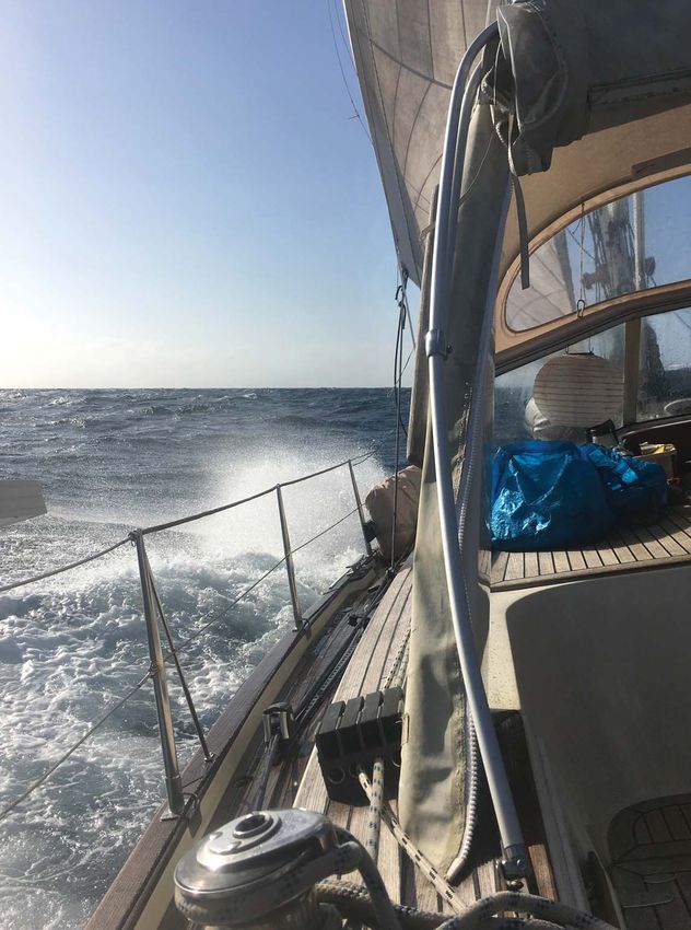
The alternative to facing the dilemma posed by a direct passage from Reunion to
South Africa is instead to head northwest from Reunion to northwest Madagascar
and thence down the Mozambique Channel to Richards Bay or Durban. The
advantage of this option is that it breaks the passage into shorter legs, thus providing
more accurate weather windows during the latter stages of the passage down the
Mozambique Channel as well as several options for seeking shelter in the event of
bad weather. It should be noted, however, that this option will take substantially
longer, especially if one intends to spend time cruising in the waters of northwest
Madagascar, reputed to be a delightful cruising ground. Accordingly, this decision
to be made well in advance and factored into one’s overall plan for crossing the
Indian Ocean – given the vagaries of the cyclone season it is not a realistic last
minute option. The passage from Reunion should be undertaken in October, as
the subsequent passage down the Mozambique Channel must take place by mid
November at the latest in order to avoid risking being caught in a cyclone or severe
revolving tropical storm (RTS).
   Once safely in Richards Bay or Durban the next challenge is to negotiate the South
African coast round to Cape Town. The overall length of the passage is 800 miles from
Durban, and a further 85 from Richards Bay. With southwesterly depressions barrelling
up the coast every two or three days one would be lucky to make the trip in one go.
Therefore the trick is to work out how much progress one can make in the window
between depressions before the next one comes through. It should be remembered that
the Agulhas Current can provide a significant boost to progress, especially between
Durban and East London where it really kicks in 40 miles south of Durban. In favourable
conditions it is quite possible to achieve a 240-mile day on this stretch of coast, and
this should be taken into account. The other factor to be considered is the weather for
rounding Cape Agulhas. In strong conditions, with winds in excess of 20 knots from
either direction, the sea state can rapidly become very unstable and unpleasant. A
further complication is the likelihood of encountering a cut-off low at some stage on
the passage. These are generated off the land and in most cases are of relatively short
duration, few lasting more than six hours. Consequently they are harder to forecast
accurately. However, their potential impact on a passage plan in terms of imposing
delay can be significant. Thus it is important to factor some reserve time into one’s
plan to allow for the possibility of encountering one.
   Unlike the passage from Reunion, where one has to set off blind, there is no need
to do so when sailing down the South African coast, as there is a wealth of accurate
weather information available from the South African Meteorological Service and
other weather sources such as PredictWind, PassageWeather and Windguru. However,
it is important to monitor these sources very carefully as the detail changes on a daily
basis, particularly with regard to timing. With careful passage planning taking full
advantage of weather windows there is no excuse for being caught out in bad weather
on this stretch of coast unless one has the misfortune to suffer major gear failure. It
is also important to maintain the average speed estimated in the passage plan, and to
be prepared to turn the engine on if wind strength drops below what is necessary to
maintain the required speed over the ground. Winds in a weather window can often
be on the light side, so one should expect to motor for a considerable amount of time
– that was certainly our experience down this stretch of coast.

                                          44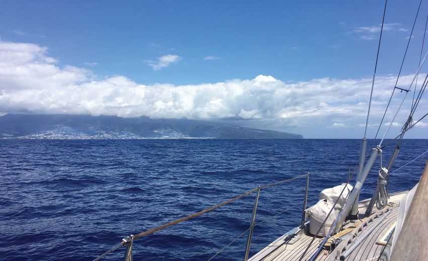
Leaving Reunion
behind

So how did Sofia cope with these challenges as we crossed the Indian Ocean to South
Africa in the autumn of 2017? Mid October found her berthed in Port de Galets marina
in Reunion, with her crew looking for a weather window to depart for Richards Bay.
Mindful of the challenges and uncertainties involved in the passage ahead, which had
been on our minds for some time, we decided that it would be sensible to employ the
services of a professional weather router. After reading an online article in Yachting
World about why ocean cruisers should consider using a weather router we found Simon
Rowell, who is meteorologist for the UK Sailing Team and the Clipper Race. He is
also an ocean sailor who has made two passages in these waters, so we were confident
that we would receive the advice we needed. We wanted input from him in two
respects for our passage planning. The first was, when was the appropriate window to
depart Reunion and round the southern tip of Madagascar? The second was to provide
ongoing weather advice as we approached the Agulhas Current. His charges were very
reasonable and his advice proved to be both helpful and accurate.
  After signing on with Simon, Jenny Crickmore-Thompson, our PO/POR coordinator,
told us about local South African weather expert Des Cason. Des is a retired ocean sailor
based in Durban who provides free, tailored weather advice to any yacht crossing from
Reunion or Madagascar to South Africa, or sailing down the coast of South Africa, out
of the goodness of his heart. His advice was to prove invaluable both on the passage
from Reunion and then from Richards Bay to Cape Town. I would strongly advise
any yacht sailing in these waters to make use of his services. Thus armed with advice
from Des and Simon we set off from Reunion on 16 October 2017 in company with
Dreamcatcher, another OCC yacht.
  Conditions approaching the southern tip of Madagascar were relatively benign,
but at this point we noticed a major tear in our mainsail. In order to prevent further
damage we took the sail off and replaced it with the storm trysail, which slowed us
down somewhat so Dreamcatcher pulled steadily away. By now we were aware of the
existence of a strong southwesterly low making its way up the South African coast,

                                           45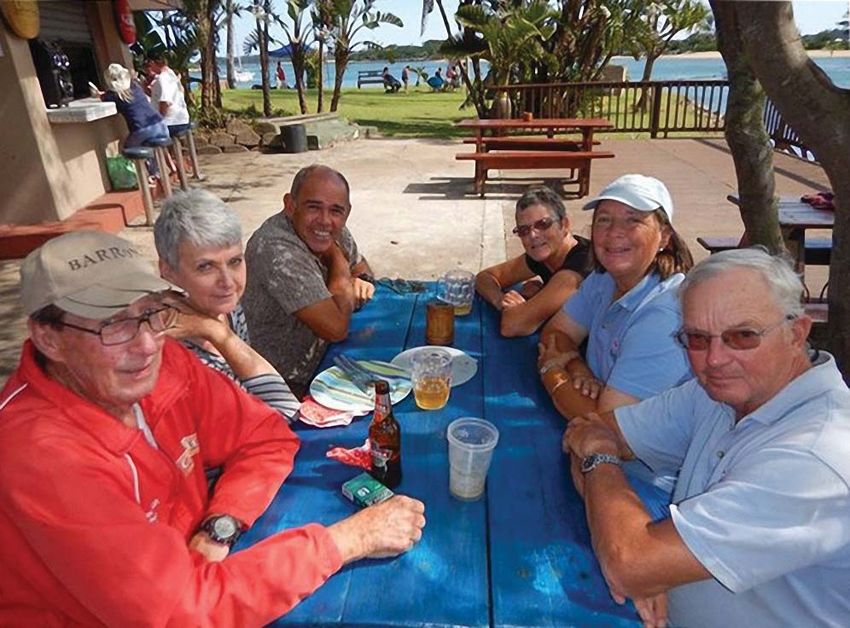
Des Cason and his wife
     Nell (left), with the
crews of Sofia (right) and
  Dreamcatcher (end) at
the Zululand Yacht Club

although at this stage it
was not entirely clear when
it would reach Richards
Bay. Consequently, rather
than heading directly for
Richards Bay, we followed
advice from Des to keep our
options open by keeping
further north and heading
west along latitude 26°S. By the time we reached longitude 30°E the situation was
much clearer and we knew we had 48 hours in which to cross to the Agulhas Current
and reach Richards Bay before the low arrived. The prevailing light winds in the
Mozambique Channel would mean motoring hard to cover the distance in the time
available, however, and as we had already motored some of the way from Reunion
to the southern tip of Madagascar, fuel consumption was now an issue. After some
careful calculations we reckoned that we had just enough to make it, with a small
reserve for emergencies.
                                   The author at the Zululand Yacht Club marina

                                       46
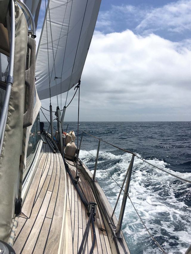
Beating to windward
    south of Durban

   After motoring
hard for 24 hours we
were in a position
to take advantage
of the favourable
winds that Des and
Simon had forecast
as we approached the
South African coast.
As the wind backed
from northwest to
southwest we were
able to follow it
round and close-
reach our way down
the coast to Richards
Bay. At that point
we took a wave over
the foredeck, which
split the genoa at the
foot, so we replaced it
with the staysail and
were able to make
it into Richards Bay
on Thursday 26
October after an 11
day passage, with six
hours to spare. Thus we were safely tied up in the smallcraft harbour in Tuzi Gazi by
the time the southwesterly gale arrived and roared through the rigging!
   At the end of November, after five very pleasant weeks at the Zululand Yacht Club
in Richards Bay it was time to head for Cape Town. Most yachts opt for this timeframe
for a variety of reasons, although the best time of year for the passage is January to
March. We felt confident that, provided we allowed sufficient time for stopovers in
the event of bad weather, we could make the 900 mile passage in 10 to 14 days and
reach Cape Town by mid December. Armed with advice from Des we reckoned that
we could reach East London in our first weather window, even though we might
encounter a small cut-off low south of Durban for six hours. Based on Des’s comment
that conditions might be uncomfortable but not dangerous, we decided to press on
rather than call in at Durban. After a bouncy 12 hours tacking south of Durban the
wind backed to the southeast and we picked up the Agulhas Current.
   With the boost from the current we rocketed down the coast, averaging 10 to 12
knots. Such was progress that we decided to bypass East London and head for Port
Elizabeth, where we would wait as the next southwesterly depression came through. It

                                         47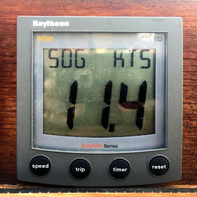
High SOG recorded in the Agulhas Current
should be noted that in spite of a very welcoming
yacht club there are two significant problems
with Port Elizabeth. The first is surge within the
harbour, and the second is coal dust from the
coal loading facility right next to the marina,
which quickly coats everything. This problem
is compounded by the severe water shortage.
Restrictions on water usage mean you cannot
use fresh water to wash off the coal dust and the
harbour water is filthy.
   Once the depression had blown through we moved on to Mossel Bay. Unfortunately
for us the strong easterlies, which would have been ideal for a quick passage to Cape
Town, made rounding Cape Agulhas problematic, so we called into Mossel Bay and
ended up on the harbour wall rafted alongside a French yacht that we had met in Port
Elizabeth. There we waited for 24 hours for an opportunity to round Cape Agulhas.
                                                                Given the go-ahead
                                                                by Des, we set off at
                                                                the crack of dawn in
                                                                order to reach the
                                                                Cape by midnight,
                                                                when the wind would
                                                                be starting to die
                                                                down. We duly arrived
                                                                at the appointed hour
                                                                and had a relatively
                                                                benign rounding.
                                                                However, as we were
                                                                motoring along in
                                                                calm winds and flat
                                                                seas towards Cape
                                                                Point, a cut-off low
                                                                suddenly materialised
                                                                with 25 knots on the
                                                                nose! Consequently
                                                                we found ourselves
                                                                beating our way up
                                                                towards Cape Point,
                                                                which delayed our
                                                                arrival in Cape Town.

                                                               Reaching
                                                               along in the
                                                               Agulhas
                                                               Current

                                         48
Table
  Mountain
     with its
 table cloth,
   seen from
   the Royal
 Cape Yacht
Club marina

Instead of arriving in daylight in reasonable winds, we found ourselves arriving at
midnight in the teeth of the ‘Cape Doctor’. Berthing in the Royal Cape Yacht Club’s
marina in the dark for the first time, with the wind gusting over 30 knots, was a
somewhat nerve-wracking experience!

With the benefit of hindsight, the passages between Reunion and Cape Town have
certainly been the most challenging of our circumnavigation to date. In light of our
experience, the following advice might be useful for those following in our wake:
• Use the services of Des Cason at sygambit@gmail.com. In our experience his advice
  is timely, customised to your requirements and invariably accurate.
• Consider additional input from a professional weather router. We found this very
  helpful, and neither Des nor Simon had a problem with it. It is always useful to
  have confirmation from an additional source.
• If you dislike uncertainty and have time in hand, consider taking the route from
  Reunion to the Mozambique Channel via northern Madagascar which has the
  added bonus of beautiful cruising grounds in northwest Madagascar. However,
  anyone contemplating this option should consult Des Cason, who can provide
  detailed information on Madagascar and the Mozambique channel.
• Consider waiting in Richards Bay or Durban until January when weather conditions
  are likely to improve before heading down to Cape Town. There is plenty to see
  and do in this part of South Africa.
• Allow at least double the normal time for the passage from Richards Bay or Durban
  to Cape Town. A 900 mile passage would normally take us six
  or seven days. We allowed 12 to 14 days and it took us 11.
• Make sure your fuel tank and cans are full, as you are
  likely to do more motoring than you expect.

                                         49
You can also read