The Western Gulf of Corinth (Greece) 2020-2021 Seismic Crisis and Cascading Events: First Results from the Corinth Rift Laboratory Network
←
→
Page content transcription
If your browser does not render page correctly, please read the page content below

The Western Gulf of Corinth (Greece) 2020–2021
                Seismic Crisis and Cascading Events: First Results
                from the Corinth Rift Laboratory Network
                George Kaviris* et al.

                       Abstract
                       We investigate a seismic crisis that occurred in the western Gulf of Corinth (Greece)
                       between December 2020 and February 2021. This area is the main focus of the Corinth
                       Rift Laboratory (CRL) network, and has been closely monitored with local seismological
                       and geodetic networks for 20 yr. The 2020–2021 seismic crisis evolved in three stages: It
                       started with an Mw 4.6 event near the northern shore of the Gulf, opposite of Aigion, then
                       migrated eastward toward Trizonia Island after an Mw 5.0 event, and eventually culmi-
                       nated with an Mw 5.3 event, ∼3 km northeast of the Psathopyrgos fault. Aftershocks
                                                                                                                                                              Cite this article as Kaviris, G., Elias, P.,
                       gradually migrated westward, triggering another cluster near the junction with the                                                     Kapetanidis, V., Serpetsidaki, A.,
                       Rion–Patras fault. Moment tensor inversion revealed mainly normal faulting; however,                                                   Karakonstantis, A., Plicka, V., De Barros, L.,
                       some strike-slip mechanisms also exist, composing a complex tectonic regime in this region                                             Sokos, E., Kassaras, I., Sakkas, V., et al.
                       dominated by east–west normal faults. We employ seismic and geodetic observations to                                                   (2021). The Western Gulf of Corinth
                                                                                                                                                              (Greece) 2020–2021 Seismic Crisis and
                       constrain the geometry and kinematics of the structures that hosted the major events. We
                                                                                                                                                              Cascading Events: First Results from the
                       discuss possible triggering mechanisms of the second and third stages of the sequence,                                                 Corinth Rift Laboratory Network, The
                       including fluids migration and aseismic creep, and propose potential implications of the                                               Seismic Record. 1, 85–95, doi: 10.1785/
                       Mw 5.3 mainshock for the seismic hazard of the region.                                                                                 0320210021.

                                                                                                                                                              Supplemental Material

                Introduction                                                                           Greece. Farther south, the Rion–Patras fault runs offshore,
                The Corinth rift (central Greece) is a Quaternary graben char-                         likely connecting to the causative strike-slip fault of the 2008
                acterized by ∼east–west normal faulting. The western Gulf of                           Movri earthquake (Serpetsidaki et al., 2014).
                Corinth (WGoC) is its most active region (Fig. 1), with an                                 In the early 2000s, the Corinth Rift Laboratory network
                extension rate reaching 15 mm · yr−1 across N009°E (Briole                             (CRLnet) was established, covering a 30 km × 30 km area in
                et al., 2021). Seismicity level is high (Makropoulos et al.,                           the WGoC (Cornet et al., 2004). CRL is one of the Near-
                2012), with the most recent M > 6 event being the 1995 M s 6.2                         Fault Observatories (NFO) of the European Plate Observing
                Aigion earthquake (Bernard et al., 1997, Fig. 1). Since 2010,                          System, and the only with an international status. It is admin-
                several events with M w ≥ 5:0 have occurred: the January 2010                          istered and maintained by the Centre National de la Recherche
                M w 5.2–5.3 Efpalio doublet (Sokos et al., 2012), the November                         Scientifique (France), the National and Kapodistrian
                2014 M w 5.0 (Kaviris et al., 2018), and the March 2019 M w 5.1                        University of Athens (NKUA-Greece), the University of
                earthquakes. Major active north-dipping structures include the
                Pirgaki, Helike, Aigion, and Psathopyrgos faults in the south,
                whereas the Marathias and Trizonia faults on the northern                              Full author list and affiliations appear at the end of this article.
                                                                                                       *Corresponding author: gkaviris@geol.uoa.gr
                coast are south-dipping and steeper. The westward continu-
                                                                                                       © 2021. The Authors. This is an open access article distributed under the terms of the CC-BY
                ation of the Psathopyrgos fault turns to the Rion–Patras fault                         license, which permits unrestricted use, distribution, and reproduction in any medium, provided the
                and runs inland north of Patras—the third-largest city in                              original work is properly cited.

                https://www.seismosoc.org/publications/the-seismic-record/ • DOI: 10.1785/0320210021                                                                    The Seismic Record                85

Downloaded from http://pubs.geoscienceworld.org/ssa/tsr/article-pdf/1/2/85/5363987/tsr-2021021.1.pdf
by guest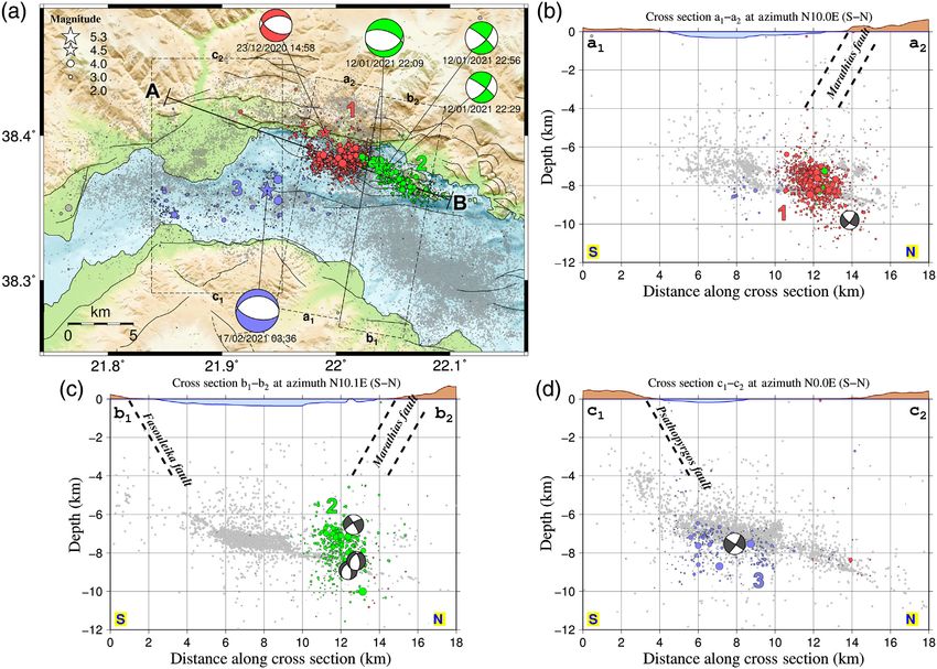
Patras (Greece), and the National Observatory of Athens                                Figure 1. Seismotectonic map of the western Corinth rift. The epicenters of
                (NOA-Greece), with the participation of Charles University                             relocated seismicity (Mw ≥ 2:0) during 2000–2015 are after Duverger
                                                                                                       et al. (2018) and are depicted as circles or stars (the latter for Mw ≥ 4:5)
                (Czech Republic). NFOs are long-term observation and research                          with size proportional to magnitude. Focal mechanisms of events with
                infrastructures, tailored to provide high-resolution multidiscipli-                    Mw ≥ 5:0 are displayed; the 15 June 1995 Ms 6.2 event is after Bernard
                nary data and products in the near field of faults of major impor-                     et al. (1997); the 2010 Efpalio doublet is after Sokos et al. (2012); other
                                                                                                       focal mechanisms by Seismological Laboratory of National and
                tance in Europe. CRLnet comprises 80+ permanent stations,
                                                                                                       Kapodistrian University of Athens (NKUA-SL). Seismological stations of
                equipped with seismometers, accelerometers, Global Navigation                          the Corinth Rift Laboratory (CRL) network are depicted by blue upright
                Satellite Systems (GNSS), tide gauges, and strainmeters (Fig. 1).                      (seismometers) and pink inverted (accelerometers) triangles; Global
                It enables detailed monitoring of the fluctuations of the intense                      Navigation Satellite Systems (GNSS) stations are represented by green
                                                                                                       squares; the in Monastiraki (MOKI) strainmeter is marked with a yellow
                microseismicity and deformation. The seismicity is clustered in
                                                                                                       diamond. The location of the western Gulf of Corinth (WGoC) in central
                time and space, with episodic seismic sequences, for example,                          Greece is shown in the inset map. For fault lines, see Kapetanidis et al.
                the 2003–2004 offshore WGoC (Duverger et al., 2015), 2013                              (2015), Duverger et al. (2018), and references therein.
                Helike (Kapetanidis et al., 2015; Mesimeri et al., 2016), and
                2015 Malamata (De Barros et al., 2020) swarms. GNSS record-
                ings and Interferometric Synthetic Aperture Radar (InSAR)                              sequence culminated with a 17 February 2021 M w 5.3 event,
                revealed the deformation sources of moderate earthquakes                               north of the eastern edge of the Psathopyrgos fault. The west-
                and the likely existence of aseismic slip at shallow depth in some                     ward expansion of the crisis raised concerns regarding poten-
                places (Elias and Briole, 2018).                                                       tial impact on the densely populated urban area of Patras. The
                    On 23 December 2020, an intense seismic crisis started in                          present study is a joint scientific effort of the CRL partners,
                the WGoC with an M w 4.6 event at the northern coast, near                             aiming to characterize the structures activated during the
                Marathias. It was followed by several larger events. The                               sequence. We calculate hypocenters, focal mechanisms,

                https://www.seismosoc.org/publications/the-seismic-record/ • DOI: 10.1785/0320210021                                                   The Seismic Record       86

Downloaded from http://pubs.geoscienceworld.org/ssa/tsr/article-pdf/1/2/85/5363987/tsr-2021021.1.pdf
by guest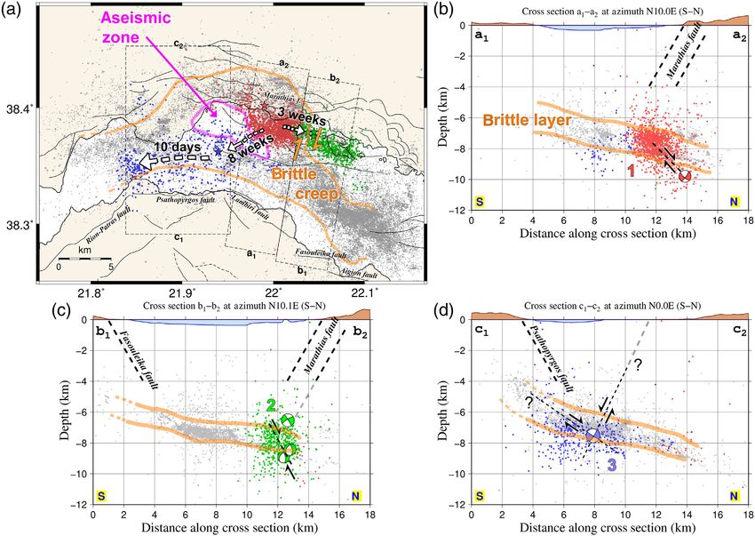
ground displacements at the GNSS stations, and Synthetic                               Figure 2. (a) Seismicity map for the period 23 December 2020–28 February
                Aperture Radar (SAR) interferograms. We analyze the seismic-                           2021 divided into three spatial groups, indicated by different colors and
                                                                                                       numbers, with events of Mw ≥ 4:5 represented by stars along with their
                ity migration, and we discuss the role of the fluids and the
                                                                                                       respective focal mechanisms. Dashed rectangles mark the directions and
                possible existence of aseismic slip.                                                   boundaries of cross sections presented in panels (b–d). Dashed lines at
                                                                                                       the cross sections (b–d) are down-dip extensions of mapped faults,
                Seismological Methods                                                                  assuming an apparent dip angle of 60°. Light-gray dots indicate relocated
                                                                                                       seismicity of 2000–2015 (Duverger et al., 2018).
                We examined the seismicity recorded in the WGoC between 23
                December 2020 and 28 February 2021. We analyzed 2960 events,
                with P- and S-wave arrival-time data manually determined at                            0.31 km in horizontal and 0.86 km in vertical, supposing an aver-
                the Seismological Laboratory of NKUA and the Geodynamic                                age arrival-time reading error (i.e., picking measurement
                Institute of NOA. Initial locations were assessed using                                discrepancy from the true P- or S-wave arrival) of 0.13 s. For
                HYPOINVERSE (Klein, 2002), tuning distance weighting by                                location uncertainties and other statistics, see Table S5 and
                excluding stations located 40+ km away from the epicenters.                            Figures S3 and S4, available in the supplemental material to this
                We employed the 1D velocity model of Rigo et al. (1996); there-                        article.
                fore, our locations are consistent with those of previous works                            To facilitate the spatial and temporal description of the crisis,
                using the same model (e.g., Duverger et al., 2018). With a mean                        we divided the seismicity into three spatial groups, correspond-
                root mean square travel-time residual of 0.11 s, the average abso-                     ing to the three main areas activated (Fig. 2). Cross sections in a
                lute location uncertainties reported by HYPOINVERSE are                                roughly north–south direction (Fig. 2b–d) indicate that the

                https://www.seismosoc.org/publications/the-seismic-record/ • DOI: 10.1785/0320210021                                                 The Seismic Record      87

Downloaded from http://pubs.geoscienceworld.org/ssa/tsr/article-pdf/1/2/85/5363987/tsr-2021021.1.pdf
by guest
hypocenters of groups 1 and 2 are located on north-dipping                             Figure 3. Displacement of the GNSS stations, including that induced by the
                structures. The steeper group 2 shows a more linear distribution                       earthquakes of 12 January and 17 February 2021.

                of its epicenters and includes strike-slip events. The sparser
                group 3 shows activity on a low-angle structure.
                   We calculated focal mechanisms through moment tensor                                M w 5.3), Sentinel-1 SAR interferometry (InSAR) shows no defor-
                inversion for the five strongest events (magnitudes between                            mation within a quarter of fringe (7 mm) in the line-of-sight
                4.5 and 5.3) using ISOLA software (Sokos and Zahradnik,                                direction. Indicatively, an interferogram of Sentinel-1 Track 80,
                2008; Zahradník and Sokos, 2018) and the velocity model of                             spanning the dates 12 and 24 January 2021, is shown in Figure S5.
                Rigo et al. (1996). We used stations from both CRLnet and                                 Modeling was performed with Inverse6 code (Briole, 2017),
                the Hellenic Unified Seismological Network, at a maximum                               using the method described by Briole et al. (1987). For both
                epicentral distance of 60 km. Details on moment tensor inver-                          the events, we assumed a north-dipping fault plane with focal
                sion are available in the Moment Tensor Inversion Additional                           mechanisms given in Table S1. Along-shore displacement was
                Information section in the supplemental material.                                      constrained to be consistent with InSAR within 7 mm. We
                                                                                                       inverted for the size, horizontal position, and depth of the rupture.
                Geodetic Methods                                                                       The best-fitting solutions are listed in Table S3. The geodetic
                GNSS data were processed using software GIPSY (version 6.4),                           moment of the 12 January 2021 event (Table S3) is ∼5 times larger
                developed by Jet Propulsion Laboratory–National Aeronautics                            than the one determined by seismology (Table S1), suggesting that
                and Space Administration. Following Briole et al. (2021), the time                     prevailing transient aseismic slip dominated during that event.
                series were corrected for the secular velocities and filtered with a
                Gaussian filter. The residual time series are plotted in Figure 3,                     Spatiotemporal evolution of the sequence
                and the coseismic displacements are listed in Table S2. For the                        Certain major characteristics of the sequence are visualized
                two main events (12 January 2021 M w 5.0 and 17 February 2021                          through the projection of the epicenters along a N110°E-oriented

                https://www.seismosoc.org/publications/the-seismic-record/ • DOI: 10.1785/0320210021                                                 The Seismic Record       88

Downloaded from http://pubs.geoscienceworld.org/ssa/tsr/article-pdf/1/2/85/5363987/tsr-2021021.1.pdf
by guest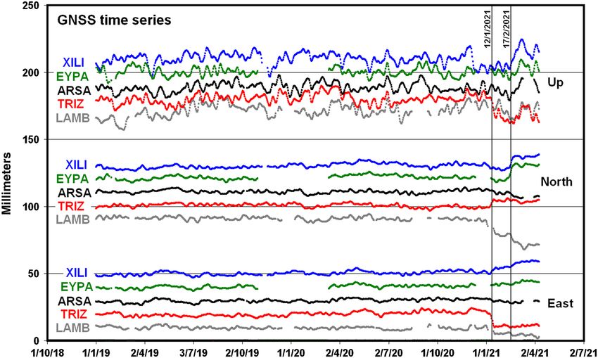
profile (line A–B of Fig. 2a) with respect to their origin time                        Figure 4. Spatiotemporal projection along the A–B profile depicted in
                (Fig. 4). Three distinct stages are identified, marked by brackets.                    Figure 2a for the period 23 December 2020–28 February 2021 (horizontal
                                                                                                       temporal axis). Colors and numbers represent the three spatial groups of
                The first stage near Marathias, involving spatial group 1 (red),
                                                                                                       Figure 2. Epicenters are depicted as circles or stars (the latter for
                begins with the 23 December 2020 M w 4.6 event and continues                           Mw ≥ 4:5) with size proportional to the magnitude. Three temporal
                with aftershocks migrating mainly eastward on a 5 km long                              stages and their main events are marked.
                structure. The second stage starts with a short foreshock activity
                in group 2 (green), approximately two days before the 12 January
                2021 M w 5.0 event near Trizonia Island. This major event trig-                        layer, already identified by CRL since 2000. The latter is a vol-
                gers seismicity that migrates both eastward and westward on a                          ume (outlined in orange in Fig. 5) interpreted as a brittle,
                12 km long alignment, penetrating the area of the previously                           highly fractured, 1–3 km thick geological layer, between 6 and
                active group 1. The third stage starts with the 17 February                            9 km depth, gently dipping north, in which the main normal
                2021 M w 5.3 event in group 3 (blue). Its seismicity is located                        faults of the WGoC are rooting (Lambotte et al., 2014;
                offshore, north of the Psathopyrgos fault. It migrates mainly                          Duverger et al., 2018).
                westward and triggers a small cluster near the junction between                           Cluster 1 occurs in an area activated at least once a year since
                the Psathopyrgos fault and the Rion–Patras fault zone. Overall, in                     2000 (except in 2003 and 2005) by similar swarms, with several
                the three month period, the crisis spans more than 20 km in an                         events larger than M 4.0. The bulk of its activity spans from 7 to
                east–west direction. The speeds of seismic migration range from                        9 km depth, consistent with the background seismicity, plotted
                few hundreds of m/day to several km/day, in most cases spread-                         for 2000–2015 in gray in Figures 2 and 5 (see also profiles 9–11
                ing over distances of a few kilometers. The faster speeds are more                     in Duverger et al., 2018). The 2020–2021 sequence starts at the
                likely driven by either afterslip in response to aftershocks, or slow                  deep southeastern edge of the 2010 M w > 5 doublet sequence
                slip when no mainshock exists, rather than by fluid diffusion, as                      (Sokos et al., 2012), with the 23 December 2020 mainshock,
                previously observed in the WGoC (e.g., De Barros et al., 2020).                        which is located less than 2 km north of the 25 April 2012
                                                                                                       M w 4.3 earthquake, yet with a slightly different focal mecha-
                Discussion                                                                             nism. The east–west-striking normal-fault mechanism of the
                Our locations show that the December 2020–February 2021                                23 December 2020 mainshock fits the local stress field, associ-
                seismic crisis activated several parts of a large-scale seismic                        ated with north–south extension (e.g., Kassaras et al., 2016).

                https://www.seismosoc.org/publications/the-seismic-record/ • DOI: 10.1785/0320210021                                                 The Seismic Record       89

Downloaded from http://pubs.geoscienceworld.org/ssa/tsr/article-pdf/1/2/85/5363987/tsr-2021021.1.pdf
by guest
However, we could not resolve unambiguously the activated Figure 5. Interpretation sketch in (a) map and (b–d) cross sections, fol-
nodal plane. lowing the layout of Figure 2. The brittle layer is marked with orange lines,
delineating the two dominant west–northwest to east–southeast-trend-
The north-dipping solution requires a blind fault patch, ing microseismic bands (one near Marathias and another south of Trizonia
necessarily small, as there is no evidence of such fault in the Island), connected by a north–south-trending band, proposed to be a
bathymetry at the expected outcropping position. This fault broad right-lateral shear zone (orange half-arrows west of Trizonia). An
aseismic zone between groups 1 and 3 is delimited in purple on the map.
could connect to the active cluster up-dip. In this case, the seis-
Proposed faults and their kinematics are marked with dashed lines and
mic gap of 1.5 km between the mainshock focus and the micro- half-arrow pairs. Light-gray dots indicate relocated seismicity of 2000–
seismic cluster might reveal the extension of the main rupture 2015 (Duverger et al., 2018).
(Fig. 5b).
The south-dipping solution would involve the Marathias
fault system, outcropping a few kilometers north of the Cluster 2 starts with a three week delay at the eastern edge of
northern shoreline. This hypothesis is less likely, as the prolon- cluster 1 (Fig. 4), with a two day foreshock sequence prior to
gation of the Marathias fault, at an assumed dip angle of 60°, the 12 January 2021 M w 5.0 mainshock. The most likely fault
misses the mainshock hypocenter by 4 km at the focal depth of plane is dipping north, owing to the shape of the western seis-
10 km, the latter value being supported by both hypocentral mic cluster and to the expected several kilometers of the rup-
location and moment tensor centroid (Table S1). However, ture (Fig. 5c). It involves an area where the seismic activity in
it directly intersects cluster 1, suggesting it may play an impor- the past 20 yr is much weaker than in the cluster 1 area. A
tant role in activating it. few kilometers eastward, the east–west-striking normal-fault
https://www.seismosoc.org/publications/the-seismic-record/ • DOI: 10.1785/0320210021 The Seismic Record 90
Downloaded from http://pubs.geoscienceworld.org/ssa/tsr/article-pdf/1/2/85/5363987/tsr-2021021.1.pdf
by guestmainshock triggers a sequence of moderate-magnitude strike- a less fractured and less permeable part of the crust. Its origin
slip events. Similar events, with dextral mechanism on the and mechanical significance require further investigation.
north-northeast-striking nodal plane, have been previously Cluster 3 displays three subareas. The broad central part,
reported in the same area (e.g., Rigo et al., 1996; Godano et al., coinciding with most of the east–west span of the Psathopyrgos
2014; Serpetsidaki et al., 2016). Consistently, structurally con- fault, exhibits low-level, diffuse seismicity. Contrariwise, there
trolled northeast–southwest mean anisotropy directions are are two narrow, active regions on both sides, with the trigger-
inferred from the data of the nearby stations PYRG and ing mainshocks to the east and a large persistent swarm to the
SERG (Kaviris et al., 2017, 2018). west (Fig. 5a). The partitioning of this area has been recur-
During the past decade, evidence of a variety of mechanical rently observed during the past 20 yr, with swarms rarely
responses to the stress field across the Corinth rift has grown spreading from one subarea to another. This stable pattern
(Sokos et al., 2012; Valkaniotis and Pavlides, 2016; Sakellariou suggests a strong structural control of the extensional dynam-
and Tsampouraki-Kraounaki, 2019). The predominant exten- ics, presumably related to the northern continuation of the
sion, expressed by the ∼east–west normal focal mechanisms, contact zone between the Psathopyrgos and the adjacent faults:
is accompanied by strike-slip faulting on localized transtensional the Rion–Patras fault to the west (see also Duverger et al.,
features. The moderate events of cluster 2 occur at the northern 2018) and the Lambiri fault to the east. The ∼east–west-
tip of the north–south-distributed main microseismic band, striking mechanism of the 17 February 2021 M w 5.3 event is
plotted with gray dots in Figure 2 (and fig. 3 of Duverger et al., not related to the Lambiri fault, but rather to the easternmost
2018). This north–south active band (marked with orange part of the Psathopyrgos fault or an unknown antithetic fault
arrows in Fig. 5) connects the two dominant microseismic segment. It has a rupture length of ∼5 km, constrained by
groups—one located to the southeast (mid-gulf, south of GNSS data modeling, and is consistent with estimates of source
Trizonia, and cluster 2) and the other to the northwest (near duration (2.0–2.5 s from preliminary source inversion and cor-
Marathias, northwest of cluster 1), both trending west-north- ner frequencies from nearby accelerometers). Its size and loca-
west to east-southeast and are subjected to dominant normal tion make the north-dipping nodal plane more likely to be the
faulting (see orange line in Fig. 5a). The north–south band could fault plane, as it better fits the rest of the microseismic volume,
constitute a broad right-lateral shear zone within the distributed in a northward-dipping layer (Fig. 5d). Notably,
seismic layer. This would fit with the north–south offset inversion of GNSS data implies a very shallow fault, with a
between the Aigion–Fasouleika and Psathopyrgos normal-fault centroid depth of 2.6 km. This is compatible with the centroid
systems. depth of 3.5 km yielded from seismological data (Table S1), but
Located just east of the strike-slip epicenters, the structure not with the hypocentral distribution. Deeper solutions lead to
reported in profiles P7 and P8 of Duverger et al. (2018) shows horizontal displacements inconsistent with the GNSS observa-
well-resolved thin active fault planes and long-term repeaters, tions and much larger residuals (Table S4). It is possible that
diagnostic of their dominant creep. This is consistent with the the rupture nucleated near 7.6 km (hypocentral depth), but
easternmost activity of cluster 2 depicted in Figure 4 (close to then most slip occurred along a shallower part of the fault.
point B), with a persistence of seismic bursts until late February The sequence of clusters mixes dominant foreshock–main-
2021, contrasting with the fast activity decay more to the west, shock–aftershock patterns prolonged with swarm-like trailing
near the mainshock. activity and internal microseismicity migration patterns. These
Eight weeks after the initiation of cluster 1, cluster 3 starts on minor diffusion episodes appear within the three clusters (see
17 February 2021, with three cascading, moderate earthquakes, Fig. 4), on 27 and 28 December 2020 for cluster 1, on 12–16
the largest being an M w 5.3 event. The in-between area is only January 2021 for cluster 2, and on 17–27 February 2021 for
slightly activated at the outset of cluster 2, presumably as a cluster 3, with migration rates of 1.5, 2.5, and 0:5 km=day,
response to the 12 January 2021 mainshock. Since 2000, it respectively. For clusters 1 and 2, the high velocities suggest
has been an area (purple zone in Fig. 5a) depleted of swarm a dominant transfer of stress through creep, assisted by the
activity, with only a few events with M > 3:0 (and ≤3:5). long-range effect of the largest coseismic ruptures. For cluster
This microseismic gap might be related to the geometry and 3, the lower velocities fit with pore-pressure diffusion in a
rheology of the brittle crust, and to the kinematics and geometry highly permeable layer, possibly assisted by creep. These values
of the normal faults that root into it. It might also correspond to contrast with the slow migration speeds (10−3 –10−1 km=day),
https://www.seismosoc.org/publications/the-seismic-record/ • DOI: 10.1785/0320210021 The Seismic Record 91
Downloaded from http://pubs.geoscienceworld.org/ssa/tsr/article-pdf/1/2/85/5363987/tsr-2021021.1.pdf
by guestpreviously observed in the central and the southern part of which include pore-pressure diffusion, slow slip, and probably
the rift and interpreted as pore-pressure diffusion in the frac- nonelastic deformation processes.
tured, seismogenic geological layer (Bourouis and Cornet,
2009; Lambotte et al., 2014; Duverger et al., 2015, 2018). Data and Resources
For cluster 3, along the Psathopyrgos fault, the 0:5 km=day Corinth Rift Laboratory network (CRLnet) comprises seismo-
speed is close to the 0:3 km=day determined by Duverger et al. logical, geodetic and geophysical subnetworks from various
(2018) for the first seismic migration across the same area, educational and research entities. The first instruments were
in August–September 2014. Interestingly, the migration was installed in 2000. Seismological data were acquired with 20
eastward in 2014 and westward in 2021. This may be explained broadband and short-period velocimeters and six accelerom-
by the eastward boost of the initial slow slip in 2014 and eters installed and operated by the following institutions:
the westward boost of the 2021 M w 5.3 event, both acting (1) the Corinth Rift Laboratory (CRL) team (CL network, data
on a similarly prestressed seismic layer, but in opposite direc- hosted at RESIF, DOI: 10.15778/RESIF.CL), (2) the National
tions. The lack of large-scale InSAR deformation for the entire and Kapodistrian University of Athens (NKUA; HA network,
2020–2021 crisis and the weak GNSS signals near the origin DOI: 10.7914/SN/HA), (3) the University of Patras (HP
time of the mainshocks show that, if any aseismic strain network, DOI: 10.7914/SN/HP), which operates certain
accompanied these mainshocks due to the inferred creep or stations jointly with Charles University, Prague, and (4) the
to pore-pressure transients, the cumulative aseismic moment National Observatory of Athens (NOA; HL network, DOI:
should not exceed that of the coseismic one, that is, 10.7914/SN/HL) (Fig. 1). Stations by the last three institutes
M o ≈ 2:02 × 1017 N × m. are also part of Hellenic Unified Seismological Network
(HUSN). Global Navigation Satellite Systems (GNSS) observa-
Conclusions and Perspectives tions were made with 13 stations (installed since 2002)—12
The 2020–2021 seismic crisis involved known active crustal operated by the CRL team and one by Geodynamic Institute
structures of the WGoC, mixing dominant foreshock–main- of NOA (GI-NOA). A three-component strainmeter (in
shock–aftershock patterns with swarm-like activity. We docu- Monastiraki [MOKI]) was installed by the CRL team in 2006,
ment the migrations of seismicity and interpret them by creep with a 3 m long sensing unit (Fig. 1). The supplemental
and pore-pressure diffusion processes. The space–time cluster- material for this article includes Section S1: Moment tensor
ing of the activity reflects the segmentation of the medium at inversion additional information and Section S2: Additional
the root of the major outcropping normal faults (i.e., Marathias tables and figures.
and Psathopyrgos), possibly activating them or their antithetic
fault systems. Data Availability Statement and Declaration
The last phase of the sequence, near the Psathopyrgos fault, Data from seismometers and accelerometers can be retrieved
may have increased the probability of a large earthquake, either from European Plate Observing System (EPOS) nodes (https://
by coulomb stress changes or by dynamic weakening of the www.orfeus-eu.org/data/eida/nodes/), European Integrated
fault induced by the strong shaking of the nearby M > 5:0 Data Archive (EIDA) nodes at RESIF, and National
events. A possible dynamic rupture cascading westward on Observatory of Athens (NOA; Evangelidis et al., 2021).
the Rion–Patras fault may further increase seismic hazard Global Navigation Satellite Systems (GNSS) data and position-
for the city of Patras. More work is needed to decipher this ing solutions are available on the Corinth Rift Laboratory
seismic sequence, and evaluate the impact on the surrounding (CRL) portal (http://crlab.eu). Phase and focal mechanism data
major faults and the overall seismic hazard in the area. of Seismological Laboratory of National and Kapodistrian
Our study highlights the need of dense, continuous mon- University of Athens (NKUA-SL) are available at http://
itoring of the active faults, especially those being close to popu- www.geophysics.geol.uoa.gr/stations/gmapv3_db/index.php?
lated cities. Each seismic crisis captured by the CRLnet arrays lang=en and of GI-NOA at http://bbnet.gein.noa.gr/HL/
provides new opportunities to refine the knowledge of the databases/database. The focal mechanism of the 25 April 2012
faults geometry, crustal structure, and rheology of the event is available at https://www.emsc-csem.org/Earthquake/
WGoC. The data and models allow to gradually gain insight tensors.php?id=263856&year=2012;UPSL. All websites were
into the fluid-related processes in the crust of the WGoC, last accessed in July 2021.
https://www.seismosoc.org/publications/the-seismic-record/ • DOI: 10.1785/0320210021 The Seismic Record 92
Downloaded from http://pubs.geoscienceworld.org/ssa/tsr/article-pdf/1/2/85/5363987/tsr-2021021.1.pdf
by guestDeclaration of Competing Interests Duverger, C., S. Lambotte, P. Bernard, H. Lyon-Caen, A. Deschamps,
The authors declare no competing interests. and A. Nercessian (2018). Dynamics of microseismicity and its
relationship with the active structures in the western Corinth rift
(Greece), Geophys. J. Int. 215, 196–221, doi: 10.1093/gji/ggy264.
Acknowledgments Elias, P., and P. Briole (2018). Ground deformations in the Corinth
The authors thank the personnel of Corinth Rift Laboratory rift, Greece, investigated through the means of SAR multitemporal
network (CRLnet) and Hellenic Unified Seismological interferometry, Geochem. Geophys. Geosys. 19, 4836–4857, doi:
Network (HUSN) who worked for the installation, operation, 10.1029/2018GC007574.
and maintenance of stations used in this article. George Evangelidis, C. P., N. Triantafyllis, M. Samios, K. Boukouras,
K. Kontakos, O.-J. Ktenidou, I. Fountoulakis, I. Kalogeras,
Kaviris, Vasilis Kapetanidis, Anna Serpetsidaki, Andreas
N. S. Melis, O. Galanis, et al. (2021). Seismic waveform data from
Karakonstantis, Efthimios Sokos, Ioannis Kassaras, Vassilis Greece and Cyprus: Integration, archival, and open access, Seismol.
Sakkas, Ioannis Spingos, Christos Evangelidis, Ioannis Res. Lett. 92, no. 3, 1672–1684, doi: 10.1785/0220200408.
Fountoulakis, Olga-Joan Ktenidou, Panayotis Papadimitriou, Godano, M., A. Deschamps, S. Lambotte, H. Lyon-Caen, P. Bernard,
and Nicholas Voulgaris acknowledge financial support by and F. Pacchiani (2014). Focal mechanisms of earthquake multip-
the HELPOS project, “Hellenic Plate Observing System” lets in the western part of the Corinth rift (Greece): Influence of the
velocity model and constraints on the geometry of the active faults,
(MIS 5002697). Maps and cross sections were drawn using
Geophys. J. Int. 197, 1660–1680, doi: 10.1093/gji/ggu059.
the Generic Mapping Tools (GMT) software (Wessel and Kapetanidis, V., A. Deschamps, P. Papadimitriou, E. Matrullo, A.
Smith, 1998). Karakonstantis, G. Bozionelos, G. Kaviris, A. Serpetsidaki, H.
Lyon-Caen, N. Voulgaris, et al. (2015). The 2013 earthquake
References swarm in Helike, Greece: Seismic activity at the root of old normal
Bernard, P., P. Briole, B. Meyer, J. Gomez, C. Tiberi, C. Berge, R. faults, Geophys. J. Int. 202, 2044–2073, doi: 10.1093/gji/ggv249.
Cattin, D. Hatzfeld, C. Lachet, B. Lebrun, et al. (1997). The Kassaras, I., V. Kapetanidis, and A. Karakonstantis (2016). On the spatial
M s 6:2, June 15, 1995 Aigion earthquake (Greece): Evidence distribution of seismicity and the 3D tectonic stress field in western
for low-angle normal faulting in the Corinth rift, J. Seismol. 1, Greece, Phys. Chem. Earth 95, 50–72, doi: 10.1016/j.pce.2016.03.012.
131–150, doi: 10.1023/A:1009795618839. Kaviris, G., C. Millas, I. Spingos, V. Kapetanidis, I. Fountoulakis, P.
Bourouis, S., and F. H. Cornet (2009). Microseismic activity and fluid Papadimitriou, N. Voulgaris, and K. Makropoulos (2018).
fault interactions: Some results from the Corinth Rift Laboratory Observations of shear-wave splitting parameters in the western
(CRL), Greece, Geophys. J. Int. 178, 561–580, doi: 10.1111/j.1365- Gulf of Corinth focusing on the 2014 M w 5:0 earthquake,
246X.2009.04148.x. Phys. Earth Planet. In. 282, 60–76, doi: 10.1016/j.pepi.2018.07.005.
Briole, P. (2017). Modelling of earthquake slip by inversion of GPS Kaviris, G., I. Spingos, V. Kapetanidis, P. Papadimitriou, N. Voulgaris,
and InSAR data assuming homogenous elastic medium, doi: and K. Makropoulos (2017). Upper crust seismic anisotropy study
10.5281/ZENODO.1098399. and temporal variations of shear-wave splitting parameters in the
Briole, P., A. Ganas, P. Elias, and D. Dimitrov (2021). The GPS veloc- western Gulf of Corinth (Greece) during 2013, Phys. Earth Planet.
ity field of the Aegean. New observations, contribution of the In. 269, 148–164, doi: 10.1016/j.pepi.2017.06.006.
earthquakes, crustal blocks model, Geophys. J. Int. 226, 468– Klein, F. W. (2002). User’s guide to HYPOINVERSE-2000, a Fortran
492, doi: 10.1093/gji/ggab089. program to solve for earthquake locations and magnitudes, U.S.
Briole, P., R. Gaulon, G. De Natale, F. Pingue, and R. Scarpa (1987). Geol. Surv. Open-File Rept. 02-171, 123 pp., available at http://
Inversion of geodetic data and seismicity associated with the Friuli geopubs.wr.usgs.gov/open-file/of02-171/ (last accessed July 2021).
earthquake sequence (1976–1977), Ann. Geophys. 4, no. B4, 481–492. Lambotte, S., H. Lyon-Caen, P. Bernard, A. Deschamps, G. Patau,
Cornet, F. H., P. Bernard, and I. Moretti (2004). The Corinth Rift A. Nercessian, F. Pacchiani, S. Bourouis, M. Drilleau, and
Laboratory, Compt. Rendus Geosci. 336, nos. 4/5, 235–241, doi: P. Adamova (2014). Reassessment of the rifting process in the
10.1016/j.crte.2004.02.001. western Corinth rift from relocated seismicity, Geophys. J. Int.
De Barros, L., F. Cappa, A. Deschamps, and P. Dublanchet (2020). 197, 1822–1844, doi: 10.1093/gji/ggu096.
Imbricated aseismic slip and fluid diffusion drive a seismic swarm Makropoulos, K., G. Kaviris, and V. Kouskouna (2012). An updated
in the Corinth Gulf, Greece, Geophys. Res. Lett. 47, no. 9, and extended earthquake catalogue for Greece and adjacent areas
e2020GL087142, doi: 10.1029/2020GL087142. since 1900, Nat. Hazards Earth Syst. Sci. 12, 1425–1430, doi:
Duverger, C., M. Godano, P. Bernard, H. Lyon-Caen, and S. Lambotte 10.5194/nhess-12-1425-2012.
(2015). The 2003–2004 seismic swarm in the western Corinth rift: Mesimeri, M., V. Karakostas, E. Papadimitriou, D. Schaff, and
Evidence for a multiscale pore pressure diffusion process along a G. Tsaklidis (2016). Spatio-temporal properties and evolution of
permeable fault system, Geophys. Res. Lett. 42, 7374–7382, doi: the 2013 Aigion earthquake swarm (Corinth Gulf, Greece), J.
10.1002/2015GL065298. Seismol. 20, no. 2, 595–614, doi: 10.1007/s10950-015-9546-4.
https://www.seismosoc.org/publications/the-seismic-record/ • DOI: 10.1785/0320210021 The Seismic Record 93
Downloaded from http://pubs.geoscienceworld.org/ssa/tsr/article-pdf/1/2/85/5363987/tsr-2021021.1.pdf
by guestRigo, A., H. Lyon-Caen, R. Armijo, A. Deschamps, D. Hatzfeld, K. Andreas Karakonstantis: Section of Geophysics–Geothermics,
Makropoulos, P. Papadimitriou, and I. Kassaras (1996). A micro- Department of Geology and Geoenvironment, National and
seismic study in the western part of the Gulf of Corinth (Greece) Kapodistrian University of Athens, Athens, Greece, https://
implication for large-scale normal faulting mechanisms, Geophys. orcid.org/0000-0002-7423-2600; Vladimír Plicka: Faculty of
J. Int. 126, 663–688, doi: 10.1111/j.1365-246X.1996.tb04697.x. Mathematics and Physics, Charles University, Prague, Czech
Sakellariou, D., and K. Tsampouraki-Kraounaki (2019). Plio- Republic, https://orcid.org/0000-0002-3316-8825; Louis De Barros:
quaternary extension and strike-slip tectonics in the Aegean, in Observatoire de la Côte d’Azur, Université Côte d’Azur, CNRS, IRD,
Transform Plate Boundaries and Fracture Zones, J. C. Duarte Géoazur, Nice, France, https://orcid.org/0000-0002-5541-9162;
(Editor), Elsevier, 339–374, doi: 10.1016/B978-0-12-812064- Efthimios Sokos: Department of Geology, Seismological Laboratory,
4.00014-1. University of Patras, Patras, Greece, https://orcid.org/0000-0002-
Serpetsidaki, A., P. Elias, M. Ilieva, P. Bernard, P. Briole, A. 7742-7251; Ioannis Kassaras: Section of Geophysics–Geothermics,
Deschamps, S. Lambotte, H. Lyon-Caen, E. Sokos, and G.-A. Department of Geology and Geoenvironment, National and
Tselentis (2014). New constraints from seismology and geodesy Kapodistrian University of Athens, Athens, Greece, https://
on the M w 6:4 2008 Movri (Greece) earthquake: Evidence orcid.org/0000-0003-1185-9067; Vassilis Sakkas: Section of
for a growing strike-slip fault system, Geophys. J. Int. 198, Geophysics–Geothermics, Department of Geology and
1373–1386, doi: 10.1093/gji/ggu212. Geoenvironment, National and Kapodistrian University of Athens,
Serpetsidaki, A., E. Sokos, and G.-A. Tselentis (2016). A ten year Athens, Greece, https://orcid.org/0000-0002-2466-7446;
Moment Tensor database for western Greece, Phys. Chem. Ioannis Spingos: Section of Geophysics–Geothermics, Department of
Earth 95, 2–9, doi: 10.1016/j.pce.2016.04.007. Geology and Geoenvironment, National and Kapodistrian University
Sokos, E., and J. Zahradnik (2008). ISOLA a Fortran code and of Athens, Athens, Greece, https://orcid.org/0000-0002-5850-5736;
a Matlab GUI to perform multiple-point source inversion of Sophie Lambotte: EOST, ITES, Université de Strasbourg, CNRS,
seismic data, Comput. Geosci. 34, 967–977, doi: 10.1016/ Strasbourg, France, https://orcid.org/0000-0003-1078-3419;
j.cageo.2007.07.005. Clara Duverger: Commissariat à l'énergie atomique et aux énergies
Sokos, E., J. Zahradník, A. Kiratzi, J. Janský, F. Gallovič, O. Novotny, J. alternatives, DAM, DIF, Paris, France, https://orcid.org/0000-0002-
Kostelecký, A. Serpetsidaki, and G.-A. Tselentis (2012). The 7814-1546; Olivier Lengliné: EOST, ITES, Université de Strasbourg,
January 2010 Efpalio earthquake sequence in the western CNRS, Strasbourg, France, https://orcid.org/0000-0003-0678-2587;
Corinth Gulf (Greece), Tectonophysics 530/531, 299–309, doi: Christos P. Evangelidis: National Observatory of Athens, Institute of
10.1016/j.tecto.2012.01.005. Geodynamics, Athens, Greece, https://orcid.org/0000-0001-8733-
Valkaniotis, S., and S. Pavlides (2016). Late Quaternary and Holocene 8984; Ioannis Fountoulakis: National Observatory of Athens,
faults of the northern Gulf of Corinth rift, central Greece, Bull. Institute of Geodynamics, Athens, Greece, https://orcid.org/0000-
Geol. Soc. Greece 50, 164, doi: 10.12681/bgsg.11715. 0003-1636-133X; Olga-Joan Ktenidou: National Observatory of
Wessel, P., and W. H. F. Smith (1998). New, improved version of Athens, Institute of Geodynamics, Athens, Greece, https://
generic mapping tools released, Eos Trans. AGU 79, no. 47, 579 orcid.org/0000-0001-5206-5699; František Gallovič: Faculty of
doi: 10.1029/98EO00426. Mathematics and Physics, Charles University, Prague, Czech
Zahradník, J., and E. Sokos (2018). ISOLA code for multiple-point Republic, https://orcid.org/0000-0002-9268-3923; Simon Bufféral:
source modeling—Review, in Moment Tensor Solutions Laboratoire de Géologie, CNRS, École Normale Supérieure, PSL
Sebastian, S. D’Amico (Editor), Springer, Cham, Switzerland, 1– University, Paris, France, https://orcid.org/0000-0002-7360-0854;
28, doi: 10.1007/978-3-319-77359-9_1. Emilie Klein: Laboratoire de Géologie, CNRS, École Normale
Supérieure, PSL University, Paris, France, https://orcid.org/0000-
0003-3239-5118; El Madani Aissaoui: Équipe de Sismologie, Institut
Authors and Affiliations de Physique du Globe de Paris, Paris, France, https://orcid.org/
George Kaviris: Section of Geophysics–Geothermics, Department of 0000-0003-1435-0936; Oona Scotti: Bureau d’Évaluation des Risques
Geology and Geoenvironment, National and Kapodistrian University Sismiques pour la Sûreté des Installations, IRSN, Fontenay-aux-Roses,
of Athens, Athens, Greece, https://orcid.org/0000-0001-8956-4299; France, https://orcid.org/0000-0002-6640-9090; Helene Lyon-
Panagiotis Elias: National Observatory of Athens, Institute for Caen: Laboratoire de Géologie, CNRS, École Normale Supérieure, PSL
Astronomy, Astrophysics, Space Applications and Remote Sensing, University, Paris, France, https://orcid.org/0000-0002-6331-0108;
Athens, Greece, https://orcid.org/0000-0002-8650-0895; Alexis Rigo: Laboratoire de Géologie, CNRS, École Normale
Vasilis Kapetanidis: Section of Geophysics–Geothermics, Supérieure, PSL University, Paris, France, https://orcid.org/0000-
Department of Geology and Geoenvironment, National and 0002-5958-9839; Panayotis Papadimitriou: Section of Geophysics–
Kapodistrian University of Athens, Athens, Greece, https:// Geothermics, Department of Geology and Geoenvironment, National
orcid.org/0000-0002-7811-1216; Anna Serpetsidaki: Department of and Kapodistrian University of Athens, Athens, Greece;
Geology, Seismological Laboratory, University of Patras, Patras, Nicholas Voulgaris: Section of Geophysics–Geothermics,
Greece, https://orcid.org/0000-0002-7085-8147; Department of Geology and Geoenvironment, National and
https://www.seismosoc.org/publications/the-seismic-record/ • DOI: 10.1785/0320210021 The Seismic Record 94
Downloaded from http://pubs.geoscienceworld.org/ssa/tsr/article-pdf/1/2/85/5363987/tsr-2021021.1.pdf
by guestKapodistrian University of Athens, Athens, Greece, https:// Normale Supérieure, PSL University, Paris, France, https://
orcid.org/0000-0001-6551-1360; Jiri Zahradnik: Faculty of orcid.org/0000-0001-6805-6295; and Pascal Bernard: Équipe de
Mathematics and Physics, Charles University, Prague, Czech Sismologie, Institut de Physique du Globe de Paris, Paris, France
Republic, https://orcid.org/0000-0002-1307-2957;
Anne Deschamps: Observatoire de la Côte d’Azur, Université Côte Manuscript received 9 June 2021
d’Azur, CNRS, IRD, Géoazur, Nice, France, https://orcid.org/0000- Published online 20 July 2021
0002-6209-9814; Pierre Briole: Laboratoire de Géologie, CNRS, École
https://www.seismosoc.org/publications/the-seismic-record/ • DOI: 10.1785/0320210021 The Seismic Record 95
Downloaded from http://pubs.geoscienceworld.org/ssa/tsr/article-pdf/1/2/85/5363987/tsr-2021021.1.pdf
by guestYou can also read


