Town of Concord, Vermont - All-Hazards Mitigation Plan Update
←
→
Page content transcription
If your browser does not render page correctly, please read the page content below
Adopted by the Town of Concord Selectboard on February 5, 2019

            Town of Concord, Vermont

      All-Hazards Mitigation Plan Update
                           Town of Concord
                              Selectboard
                              P.O. Box 317
                          Concord, VT 05824
                             (802) 695-2220
              Public Assistance Applicant #: 009-15250-00

                             Prepared by:

                       Town of Concord, Vermont

Executive Summary
In 2015, the Town of Concord began to develop the Town of Concord’s Local All-Hazard
Mitigation Plan update from the last approved plan, which was an annex to the 2005 multi-
jurisdictional; NVDA Caledonia, Essex and Orleans Counties VT Regional All-Hazards
Mitigation Plan. Mitigation planning requirements have changed considerably since 2005 and
what once constituted an approved plan for the town holds little value in the current planning
environment. While the 2005 plan was certainly reviewed in the update planning process, its
value was considered low in moving the town forward with its future mitigation efforts. The
results contained herein represent the collaborative efforts of the Town of Concord Hazard
Mitigation Planning Team and associated residents, towns and agencies that contributed to the
development of this plan. As hazard mitigation is a sustained effort to permanently reduce or
eliminate long-term risks to people and property from the effects of reasonably predictable
hazards, the town has communicated its efforts related to developing this plan to its residents and
surrounding municipalities, providing a formal opportunity to provide input and review relevant
sections of the plan. Along these lines, the town has documented the planning process so that
future updates can follow an efficient pattern in addition to capturing this important component
as means of establishing institutional memory. In realization that eligibility to receive federal
hazard mitigation grants and optimize state-level reimburse or “match” dollars during a federally
declared disaster is dependent on a federally approved plan, the town remains committed to
sustaining its mitigation efforts and by developing this plan, will have a guide for action that will
foster enhanced emphasis on mitigation in the years to come. The town realizes the importance
of mitigation inherent to its own resilience as well as means to establishing strong partnerships
with regional support agencies and associations, state government and FEMA. As the town
moves towards formally adopting this Local All-Hazards Mitigation Plan, the purpose of this
plan is to:
Identify specific natural, technological and societal hazards that impact the Town of Concord
Prioritize hazards for mitigation planning
Recommend town-level goals and strategies to reduce losses from those hazards
Establish a coordinated process to implement goals and their associated strategies by taking
advantage of available resources and creating achievable action steps
This plan is organized into 5 Sections:
Section 1: Introduction and Purpose explains the purpose, benefits, implications and goals of
this plan. This section also describes demographics and characteristics specific to Concord and
describes the planning process used to develop this plan.
Section 2: Hazard Identification expands on the hazard identification in the Concord Town
Plan (2012) with specific municipal-level details on selected hazards.
Section 3: Risk Assessment discusses identified hazard areas in the town and reviews previous
federally-declared disasters to identify what risks are likely in the future. This section presents a
hazard risk assessment for the municipality, identifying the most significant and most likely
hazards which merit mitigation activity. The most significant hazards for Concord have been
profiled and are introduced in the grid below:
Town of Concord All-Hazards Mitigation Plan adopted____________ i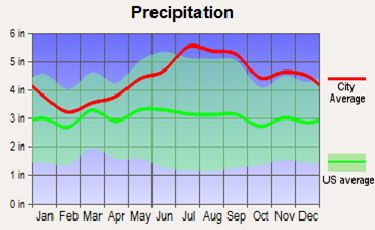
Severe winter/Ice storm         Flooding
 Extreme Cold
Section 4: Vulnerability Assessment discusses buildings, critical facilities and infrastructure in
designated hazard areas and estimates potential losses.
Section 5: Mitigation Strategies begins with an overview of goals and policies in the most
recent Town Plan that support hazard mitigation and utilizes a current road inventory to
formulate a work plan around major infrastructure projects. An analysis of existing municipal
actions that support hazard mitigation, such as planning, emergency services and actions of the
highway department are also included. The following all-hazards mitigation goals are
summarized below: Reduce at a minimum, and prevent to the maximum extent possible, the loss
of life and injury resulting from all hazards.
1) Reduce at a minimum, and prevent to the maximum extent possible, the loss of life and
   injury resulting from all hazards.
2) Mitigate financial losses and environmental degradation incurred by municipal, educational,
   residential, commercial, industrial and agricultural establishments due to various hazards.
3) Maintain and increase awareness amongst the town’s residents and businesses of the
   damages caused by previous and potential future hazard events as identified specifically in
   this Local All-Hazards Mitigation Plan.
4) Recognize the linkages between the relative frequency and severity of disaster events and the
   design, development, use and maintenance of infrastructure such as roads, utilities and storm
   water management and the planning and development of various land uses.
5) Maintain existing municipal plans, programs and ordinances that directly or indirectly
   support hazard mitigation.
6) Develop a mechanism for formal incorporation of this Local All-Hazards Mitigation Plan
   into the municipal comprehensive plan as described in 24 VSA, Section 4403(5). This
   mechanism will be developed by the Planning Commission, Selectboard and NVDA and
   integrate the strategies into the existing town plan as annexes until the next formal update
   occurs, where a section devoted to mitigation planning will be integrated into the plan.
7) Develop a mechanism for formal incorporation of this Local All-Hazards Mitigation Plan
   particularly the recommended mitigation actions, into the municipal/town operating and
   capital plans & programs as they relate to public facilities and infrastructure. With the
   development of the road erosion site inventory, the town will begin a process that
   incorporates the budgetary requirements of the defined mitigation strategies into its formal
   budgeting paradigm. The Planning Commission will review the LHMP and use
   language/actions from it to inform the integration and update process. Town Meeting Day
   will serve as the formal time that mitigation strategy budgetary considerations will be
   approved and incorporated into the town budget.

Section 5 also identifies and provides a detailed discussion on the following mitigation actions:
Action #1: Reduce flood-related impacts through infrastructure upgrades, improvement projects
           and floodplain management activities.
Action #2: Improve resilience to severe winter storms

 Town of Concord All-Hazards Mitigation Plan            adopted____________                ii
Action #3: Reduce impact of extreme cold durations Action #4: Raise public awareness of hazards and hazard mitigation actions Action #5: Continue fluvial geomorphology assessments in collaboration with DEC and develop strategies and regulatory actions in response to identified risk In conclusion, Section 5 provides an Implementation Matrix to aid the municipality in implementing the outlined mitigation actions with an annual evaluation process to be coordinated and administered by the Concord Planning Commission. Town of Concord All-Hazards Mitigation Plan adopted____________ iii
Table of Contents
SECTION 1: INTRODUCTION AND PURPOSE .................................................................... 1
1.1        Purpose and Scope of this Plan ....................................................................................... 1
1.2        Hazard Mitigation ........................................................................................................... 1
1.3        Hazard Mitigation Planning Required by the Disaster Mitigation Act of 2000 ............. 1
1.4        Benefits ........................................................................................................................... 2
1.5        All-Hazards Mitigation Plan Goals ................................................................................. 2
1.6        Town of Concord Population and Characteristics .......................................................... 3
       1.6.1 Population: ................................................................Error! Bookmark not defined.
       Table 1-1 Town of Concord, selected population characteristics, 2010 Census ....... Error!
       Bookmark not defined.
       1.6.2. Housing: ...................................................................Error! Bookmark not defined.
       1.6.3. Income and Employment: ........................................Error! Bookmark not defined.
       1.6.4. Town Locations: ....................................................................................................... 5
1.7        Summary of Planning Process ........................................................................................ 6
SECTION 2: HAZARD IDENTIFICATION ............................................................................. 8
2.1 Natural Hazards: Profiled and Non-Profiled .......................Error! Bookmark not defined.
       Table 2-1: Summary of Vermont Emergency Declarations ............................................... 9
       Table 2-2: Summary of Vermont Major Disaster Declarations since 1998 (Essex County
       in Bold with events that resulted in PA funding for the town with an “(*)”) ................... 10
       Table 2-2.1. Summary of Concord Declared Disaster where PA was Received .............. 11
2.1.1. Profiled Hazards: ........................................................................................................... 11
An Introduction to Climate Change: ......................................................................................... 11
    High Winds ........................................................................Error! Bookmark not defined.
       Table 2-3: Beaufort Scale and Concord Windspeed vs. U.S. Average... Error! Bookmark
       not defined.
       Severe Winter Storm ......................................................................................................... 12
       Table 2-4: NOAA’s Regional Snowfall Index (RSI) and CONCORD Snowfall vs. U.S.
       Average ............................................................................................................................. 13
       Concord Snowfall vs. U.S. Average ................................................................................. 13
       Ice Storm ........................................................................................................................... 14
       Extreme Temperatures ...................................................................................................... 14
Flooding .................................................................................................................................... 14
    Table 2-7: Concord Precipitation vs. U.S. Average.......................................................... 17

Town of Concord All-Hazards Mitigation Plan                                    adopted____________                                   iv
Inundation and Floodplains............................................................................................... 18
Fluvial Erosion .................................................................................................................. 19
Ice Jams ............................................................................................................................. 20
SECTION 3: RISK ASSESSMENT ......................................................................................... 20
3.1 Designated Hazard Areas.................................................................................................... 20
3.1.1. Flood Hazard Areas ................................................................................................ 20
3.1.2. Fluvial Erosion Hazard Areas ................................................................................. 21
3.2 Non-designated Hazard Areas ............................................................................................ 21
3.2.1. Ice Storm Damage.................................................................................................. 21
3.2.2. High Winds and Lightning...................................................................................... 22
3.3 Previous FEMA-Declared Natural Disasters and Non-Declared Disasters ........................ 22
Table 3-1: KEY: ................................................................................................................ 22
Table 3-2: Town of Concord, FEMA-declared disasters and snow emergencies, 2004-
Current: ............................................................................................................................. 23
3.3 Hazard Assessment and Risk Analysis ............................................................................... 25
3.3.1. Natural Hazards ................................................................................................ 26
Table 3-2 Natural hazards risk estimation matrix ............................................................. 27
3.4 Hazard Summary ................................................................................................................ 28
SECTION 4: VULNERABILITY ASSESSMENT .................................................................. 28
4.1 Critical Facilities ........................................................................................................... 32
4.2 Infrastructure ................................................................................................................. 32
4.2.1 Town Highways ....................................................................................................... 33
4.2.2 Bridges, Culverts, and Dams ................................................................................... 33
Table 4-4 Inventoried bridges in the Town of Concord with identified importance ........ 34
4.2.3 Water, Wastewater and Natural Gas Service Areas................................................. 35
4.2.4 Electric Power Transmission Lines and Telecommunications Land Lines ............. 35
4.3 Estimating Potential Losses in Designated Hazard Areas ............................................ 35
4.4 Land Use and Development Trends Related to Mitigation .......................................... 35
4.4.1. Proposed Land Use ................................................................................................. 36
4.4.2. Land Use Goals ....................................................................................................... 37
4.4.3. Land Use Strategies ................................................................................................ 37
4.4.4 Future Development and Housing ........................................................................... 38
SECTION 5: MITIGATION STRATEGIES ........................................................................... 38
Town of Concord All-Hazards Mitigation Plan adopted____________ v5.1 Town Goals and Policies that support Hazard Mitigation ............................................ 38
5.1.1. Community Goals ................................................................................................... 39
5.1.2. Capital Improvement Goals .................................................................................... 40
5.1.3. Public Participation Goals....................................................................................... 40
5.1.4. Regulatory Devices Goals....................................................................................... 40
5.1.5. Land Use ................................................................................................................. 40
5.1.6 Natural Resources .................................................................................................... 41
5.1.7. Policies .................................................................................................................... 42
5.1.8. Transportation Plan ................................................................................................. 42
5.1.9. Utilities and Facilities Goals ................................................................................... 43
5.1.9.1. Educational Goals ................................................................................................ 43
5.2 Existing Town of Concord Actions that Support Hazard Mitigation ........................... 43
5.2.1. Flood Resilience Goals: .......................................................................................... 45
5.2.2. Flood Resilience Strategies: .................................................................................... 46
5.3 Town of Concord All-Hazards Mitigation Goals ......................................................... 46
5.4 Mitigation Actions ........................................................................................................ 47
5.4.1. Current Capabilities and Need for Mitigation Actions ........................................... 48
5.4.2. Specific Mitigation Actions .................................................................................... 48
5.4.3. Prioritization of Mitigation Strategies .................................................................... 54
5.5 Implementation and Monitoring of Mitigation Strategies .................................................. 57
5.5.1. Public Involvement Following Plan Approval ....................................................... 57
5.5.2. Project Lead and Monitoring Process ..................................................................... 57
5.5.4. Plan Update Process ................................................................................................ 58
5.5.5. Implementation Matrix for Annual Review of Progress......................................... 58
Appendix E: Town of ConcordRoad Erosion Site Inventory .......... Error! Bookmark not
defined.
APPENDIX F: Community Outreach Form ..................................................................... 67
Town of Concord All-Hazards Mitigation Plan adopted____________ viSECTION 1: INTRODUCTION AND PURPOSE
1.1 Purpose and Scope of this Plan
The purpose of this Local All-Hazards Mitigation Plan is to assist this municipality in identifying
all hazards facing their community and in identifying strategies to begin to reduce the impacts of
those hazards. The plan also seeks to better integrate and consolidate efforts of the municipality
with those outlined in the Town Plan as well as efforts of NVDA, Vermont State agencies,
FEMA and the State Hazard Mitigation Plan. The town is aware that community planning can
aid significantly in reducing the impact of expected, but unpredictable natural and human-caused
events. This document constitutes an All-Hazards Mitigation Plan for the Town of Concord.
Community planning can aid significantly in reducing the impact of expected, but unpredictable
natural and human-caused events. The goal of this plan is to provide hazard mitigation strategies
to aid in creating disaster resistant communities throughout Essex County.
1.2 Hazard Mitigation
The Vermont State All-Hazards Mitigation Plan of 2013 defines hazard mitigation as:
“Any sustained action that reduces or eliminates long-term risk to people and property from
natural and human-caused hazards and their effects. The Federal Emergency Management
Agency (FEMA) and state agencies recognize that it is less expensive to prevent disaster or
mitigate its effects than to repeatedly repair damage after a disaster has struck. This plan
recognizes that communities have opportunities to identify mitigation strategies and measures
during all of the other phases of Emergency Management—Preparedness, Response and
Recovery. Hazards cannot be eliminated, but it is possible to determine what the hazards are,
where they are, where they are most severe and to identify actions that can reduce the severity
of the hazard.”
Hazard mitigation strategies and measures can reduce or eliminate the frequency of a specific
hazard, lessen the impact of a hazard, modify standards and structures to adapt to a hazard, or
limit development in identified hazardous areas. This plan aligns and/or benefits from the 5 goals
accomplished as a State since 2010 and as referenced in Section 5 of the State’s 2013 Hazard
Mitigation Plan and as part of the newly created Emergency Relief Assistance Funding (ERAF)
requirements. With enhanced emphasis on community resiliency, many state agencies and local
organizations have an increased awareness of the importance of mitigation planning and have
produced plans and resources that towns can use to support their planning efforts. This plan will
reference, when relevant, pertinent tools and resources that can be used to enhance mitigation
strategies.
1.3 Hazard Mitigation Planning Required by the Disaster Mitigation Act of
2000
Hazard mitigation planning is the process that analyzes a community’s risk from natural hazards,
coordinates available resources, and implements actions to reduce risks. Per 44 CFR Part 201:
Hazard Mitigation Planning, this planning process establishes criteria for State and local hazard
mitigation planning authorized by Section 322 of the Stafford Act as amended by Section 104 of
the Disaster Mitigation Act of 2000. Effective November 1, 2003, local governments now must
have an approved local mitigation plan prior to the approval of a local mitigation project funded
through federal Pre-Disaster Mitigation funds. Furthermore, the State of Vermont is required to
Town of Concord All-Hazards Mitigation Plan adopted____________ 1adopt a State Pre-Disaster Mitigation Plan for Pre-Disaster Mitigation funds or grants to be
released for either a state or local mitigation project after November 1, 2004.
There are several implications if the plan is not adopted:
After November 1, 2004, Flood Mitigation Assistance Grant Program (FMAGP) funds will
be available only to communities that have adopted a local Plan
For disasters declared after November 1, 2004, a community without a plan is not eligible for
HMGP project grants but may apply for planning grants under the 7% of HMGP available
for planning
For the Pre-Disaster Mitigation (PDM) program, a community may apply for PDM funding
but must have an approved plan to receive a PDM project grant
For disasters declared after October 14th, 2014, a community without a plan will be required
to meet a greater state match when public assistance is awarded under the ERAF
requirements (Emergency Relief Assistance Funding)
1.4 Benefits
Adoption and maintenance of this Hazard Mitigation Plan will:
Make certain funding sources available to complete the identified mitigation initiatives that
would not otherwise be available if the plan was not in place
Lessen the receipt of post-disaster state and federal funding because the list of mitigation
initiatives is already identified
Support effective pre-and post-disaster decision making efforts
Lessen each local government’s vulnerability to disasters by focusing limited financial
resources to specifically identified initiatives whose importance have been ranked
Connect hazard mitigation planning to community planning where possible
1.5 All-Hazards Mitigation Plan Goals
This All-Hazards Mitigation Plan establishes the following general goals for the town and its
residents:
1) Reduce at a minimum, and prevent to the maximum extent possible, the loss of life and
injury resulting from all hazards.
2) Mitigate financial losses and environmental degradation incurred by municipal, educational,
residential, commercial, industrial and agricultural establishments due to various hazards.
3) Maintain and increase awareness amongst the town’s residents and businesses of the
damages caused by previous and potential future hazard events as identified specifically in
this Local All-Hazards Mitigation Plan.
4) Recognize the linkages between the relative frequency and severity of disaster events and the
design, development, use and maintenance of infrastructure such as roads, utilities and storm
water management and the planning and development of various land uses.
Town of Concord All-Hazards Mitigation Plan adopted____________ 25) Maintain existing municipal plans, programs and ordinances that directly or indirectly support hazard mitigation. 6) Develop a mechanism for formal incorporation of this Local All-Hazards Mitigation Plan into the municipal comprehensive plan as described in 24 VSA, Section 4403(5). This mechanism will be developed by the Planning Commission, Selectboard and NVDA and integrate the strategies into the existing town plan as annexes until the next formal update occurs, where a section devoted to mitigation planning will be integrated into the plan. 7) Develop a mechanism for formal incorporation of this Local All-Hazards Mitigation Plan particularly the recommended mitigation actions, into the municipal/town operating and capital plans & programs as they relate to public facilities and infrastructure. With the development of the road erosion site inventory, the town will begin a process that incorporates the budgetary requirements of the defined mitigation strategies into its formal budgeting paradigm. The Planning Commission will review the LHMP and use language/actions from it to inform the integration and update process. Town Meeting Day will serve as the formal time that mitigation strategy budgetary considerations will be approved and incorporated into the town budget. 1.6 Town of Concord Population and Characteristics The Town of Concord covers 34,209 contiguous acres and is located at the south-eastern end of the Northeastern Vermont Development Association’s district. There are five distinct villages established within Concord's borders: West Concord, North Concord, Miles Pond, East Concord and Concord Corners. Most of the development in Concord is concentrated along the major east- west transportation corridor, Vermont Highway 2. The majority of the town's road system is gravel surfaced. These roads provide an adequate and energy efficient transportation system. The town roads are maintained by the town road maintenance crew. I-93 and I-91 intersections are located in the neighboring town of St., Johnsbury. These major interstate highways provide easy access to the Town of Concord. The Moore Reservoir, a large body of dammed water on the Connecticut River, is the southern border of Concord. The majority of the town is sparsely populated. The Village of Concord, North Concord, Miles Pond and East Concord represent the only areas supporting medium to high density development. Many of the town's seasonal homes and camps are located in properties around Miles Pond and Shadow Lake. Northern Concord landscape is dominated by the Miles Mountain range which sports the town's highest elevations (2,432 feet). This undeveloped area is composed of steep forested slopes. Central Concord's Goudreault Hill (2,012 feet) has gentler slopes which guide the area's rain and snow runoff into natural watershed collection areas including Miles Pond. Shadow Lake is a collection area for the Shaw Mountain (1,800 feet) watershed. East Concord's elevations average between 800 and 1,100 feet. These lands are made up of rolling hills and some fairly level zones. West Concord's lowlands are separated by the Moose River (elev. 800 feet). The higher elevations in western Concord, averaging 1,100 feet in elevation, are predominantly rolling hills that melt into the town's only meadow lands. The town's highlands have provided Concord's residents and wildlife with a number of water supplies. At the same time, multiple elevation Town of Concord All-Hazards Mitigation Plan adopted____________ 3
changes within the town's lowlands tend to restrict the area's development and agricultural
potential.

The 2010 U.S. Census reports a population of 1235 residents, 50.5% male and 49.5% female,
indicating a population density of 23 people per square mile. The Town’s population has shown
slow to moderate growth over the past 50 years—a rate that has increased somewhat over the
past decade. About 24% of the population is younger than 20 years, about 22% is between 20
and 40 years of age, about 32% is between 40 and 60 years, and 22% is aged 60 or older. The
median age is 43 years.

Table 1-1 Town of Concord, selected population characteristics, 2010 Census
 Category                                        Number        %
 Total Population                                1235          100
 Median Age                                      42.8          --
 Population age 60 years and over                272           22
 Population under 20 years old                   293           24
 Population between 20 and 40                    269           22
 Population between 40 and 60                    401           32

Housing:
The entire population of Concord is housed, with more than half living in traditional nuclear
families, a third living in non-family households, and about one-quarter living alone. The
average family size is 2.8 and the average household size is 2.3. About 65% of Town residents
are in the civilian labor force and 35% are not, with an unemployment rate of 3.7%, which is
lower than state and national unemployment rates. About 30% of households have annual
incomes below $25,000, about 35% between $25,000 and $50,000, 19% between $50,000 and
$75,000, and 9% above $75,000. The average annual household income is about $55,000.
About one-quarter of the Town’s housing stock was built before 1950. Almost half was built
between 1960 and 1990. About 25% has been built since 1990. About half of the housing is
valued between $50,000 and $150,000, with another half valued between $150,000 and
$300,000. More than 80% of the housing is owner-occupied, with about 20% rented. Rental costs
range from $500 to $1500 per monthThe following shows the types of housing within Concord,
also based on the 2010 U.S. Census data:

Table1-2 Town of Concord, selected housing unit data, 2010 Census Block Group 2
 Category                                       Number          %
 Total Housing Units                            806             --
 Occupied housing units                         522             64
 Vacant housing units                           294             36
 Owner-Occupied                                  439            84
 Renter Occupied                                83              16
 Population in Renter-occupied                  226
 Households with individuals under 18           143             27

 Town of Concord All-Hazards Mitigation Plan           adopted____________                    4

   Town of Concord All-Hazards Mitigation Plan             adopted _________________ 4
1.6.4. Town Locations and Services: Hospitals and medical centers near Concord: Northeastern Vermont Regional Hospital: Critical Access Hospital St. Johnsbury, VT Health and Rehab FMC OF ST. Johnsbury Dialysis Essex Home Health Care Pines Rehab and Health Center North Country Home Health and Hospice Agency (Littleton, NH) Lafayette Center, Genesis Healthcare (Franconia, NH) Electric power is provided to the town by Central Vermont Public Service. The majority of the electric service is provided along the town's road system. Three phase power is available at all three of the town's village areas. With few exceptions, power is provided via overhead transmission lines. Concord offers no municipal water or sewage services. The town's zoning regulations currently allow high density development in the village areas and a small area around Miles Pond. At some point in the future, municipal water or sewage services may be required in one or more of these zones. The Town of Concord supports two school buildings and a gymnasium, a town office/library building, a town hall which is the home of the town museum, a fire station, town garage, a state certified waste transfer station, six cemeteries, a recreation area, two state owned boat launch sites located on Shadow Lake and Miles Pond and a Community Park, donated by the Bona Family, that includes a ball park and an outdoor ice skating rink. The town owns several other undeveloped plots of land within the community. The town's volunteer fire department and FAST squad serve the community under the umbrella of the area's mutual aid organization. Training, at all levels of emergency service, has a high priority within these organizations. The department has four fire trucks, two tankers and two pumpers. Concord maintains three (3) dry hydrants. St. Johnsbury, Concord and Lunenburg are back-up responders as part of a mutual aid district. The town does not maintain a police department. The town elects a Town Constable each year. The constable is backed up by the Vermont State Police and the Sheriff's Department. The Concord Health Center is the community's only health care facility. It provides general and emergency services. Emergency ambulance services are provided by a number of out of town agencies including the Calex Ambulance service. Concord maintains its own K - 12 school system. This system also provides educational services to neighboring communities on a tuition basis. The town's two school buildings have been identified as structures that require both structural and internal upgrading. The Concord school system has a student population of approximately 250 children. The system provides K-12 services for both Concord students and children from neighboring communities. Grades 1-3 attend the school facility located in East Concord and the remainder of the grades attend school in the facility located in the Village of Concord. Both of the school facilities currently require Town of Concord All-Hazards Mitigation Plan adopted____________ 5
major upgrading to meet the safety and operational requirements set by the town and state
governments. The school is the community emergency shelter but does not have a generator.
Concord is working on a shelter pre-agreement with Vermont Red Cross. The school has its own
public water supply and requires a certified water operator.

Logging within the town's 4,065 wooded acres still represents an important part in the town's
economic structure. Most of the town's seasonal homes are built around Miles Pond and Shadow
Lake. The Connecticut River and the Moore Reservoir also offers recreational opportunities for
locals and vacationers alike. All of these systems are part of the watershed system that supplies
surface and subsurface waters to Concord and neighboring towns and cities. While the
recreational value of these waters is well known, their true value lies in their ability to collect,
filter, store and deliver water to thousands of regional residents.

High risk populations include two nursing homes and six day care facilities. Some of the day
care facilities only operate on a seasonal basis. There are a few elderly people on Lifeline and
some have extra tanks of oxygen. Generators at nursing homes are unknown. There are some
residences that would be inaccessible if severe flooding were to take place on some of the back
roads. The populations along Miles Pond and Shadow Lake may be cut off from access.

1.7    Summary of Planning Process

In October, 2015, NVDA signed a Memorandum of Understanding with the town of Concord,
Vermont to develop their Local Hazard Mitigation Plan Update. NVDA staff worked with the
town to obtain the required data and public input to develop the draft. In 2017, a local technical
support consultant assisted the town in preparing the update for submission. Monthly updates on
plan development were included in each Selectboard meeting as well during plan development.
These updates coincided with frequent emails and phone calls to planning team members. The
planning team appointed and approved by the selectboard and developed/reviewed each section
of the plan as it was drafted. As with all selectboard meetings, the community is welcome.
However, no specific input from the community in adjunct to the survey was received, therefore
inclusion of the record of attendance is omitted. The April 2018 warned selectboard meeting
with planning team members reviewed the risk assessment and specific vulnerabilities. The
Concord Hazard Mitigation Planning Team included:

Judy Kurtz            Planning Board
George Morehouse      Selectboard Chair
Cynthia Stuart        Planning and School Board, health center represtative
Richard Fisher        Fire Chief
Alan Smith            Zoning Admin
Dane Thorgalsen       Road Foreman
Heather Robinson      Essex County Natural Resources Conservation district
Susan LaMadeleine     Selectboard Administration
Frank Malony          NVDA

 Town of Concord All-Hazards Mitigation Plan            adopted____________                 6
The team represented the community as best as possible, including the school, long-standing
residents, town staff, planners and community-based organizations. In warned selectboard
meetings and in correspondence with the NVDA and consultant, the planning team discussed the
planning process and facts related to the town. Additionally, a survey was drafted asking for
community input and made available through the town’s standard public notification process and
via online survey platform Survey Monkey. The survey introduced the importance and
informational needs of a LHMP and asked for more town-specific concerns the residents and/or
business owner had. 20 responses were received with detailed inclusion of questions and
responses in Appendix F. In summary, the town concerns should, for the most part, reflect the
concerns of the residents and that is reflected in the quantitative risk assessment, profiled hazards
and subsequent mitigation strategies. Monthly updates on plan development were included in
each Selectboard meeting as well during plan development. These updates coincided with
frequent emails and phone calls to planning team members. The planning team was involved and
reviewed each section of the plan. Specifically, the April 2018 warned selectboard meeting with
planning team members reviewed the risk assessment and specific vulnerabilities. Following
FEMA guidance in Local Mitigation Plan Review Tool Regulation Checklist and FEMA
informational resources, the plan was written using data sources that included:
Surveys and warned, public meetings collecting public comment (issues raised were
addressed in plan and the public meeting)
2012 CONCORD Town Plan (provided town data, current goals and regulations
supporting mitigation, recent capital expenditures and infrastructure value helped to drive
vulnerability assessment)
2016 CONCORD Zoning Regulations Draft (Used for current flood hazard regulations
and land use planning)
2013 Vermont State Hazard Mitigation Plan (provided key guidance language and
definitions throughout the plan).
Vermont Agency of Natural Resources (ANR) and Transportation (VTrans) (Provided
key policy recommendations on environmental conservation, high accident locations,
climate change and fluvial erosion data).
Vermont Departments of Health (VDH) and Environmental Conservation (DEC)
(provided information related with public health services that could be impacted during a
disaster and state support functions designated to both VDH and DEC. DEC also
provided river corridor data for mapping purposes.
FEMA Open Source (data.gov) Data for Disaster History and PA funding (provided
comprehensive declared disaster by year and type as well as project descriptions and cost
per event).
FEMA NFIP “Bureau.Net” database (provided detailed information on repetitive loss
properties and associated flood insurance claims).
EPA’s Incident Action Checklist for cold weather resilience of water systems (provides a
guidance tool for public works to cross-reference actions on the system).
Town of Concord All-Hazards Mitigation Plan adopted____________ 7 2013 ACCD Mobile Home Resilience Plan (served as resource for future mitigation
actions)
While many small communities in Vermont face similar circumstances (e.g. flooding, winter
storms and remote residents), each one has unique considerations and opportunities. There was a
point made to capture the subtle characteristics of the town, its history and its residents. From
this, the specific risks, vulnerabilities and mitigation strategies were developed.
NVDA’s role in assisting the entire region with all facets of planning provided crucial
information and NVDA’s Emergency Management Planning representative attended planning
team meetings and provided guidance. While the LEPC provides the best platform to engage
representatives from various towns and agencies, all bordering towns to Concord (Kirby,
Victory, Waterford and Lunenburg) were contacted with planning objectives and asked to
provide input in addition to receiving a draft plan with an invitation to comment via email
through the town clerk. No comments were received. DEMHS also has representation at the
LEPC meetings and will continue to provide input and guidance as the town moves forward with
their mitigation strategies.
On May 1st, 2018, the town held a warned public meeting to review the identified hazards and
associated mitigation strategies. The draft plan was then revised based on input and presented to
the town. Much of input from residents (e.g. survey results) focused on road infrastructure
washouts, extended power failure, lack of cell service and emergency notification (full survey
included in appendix). The revised draft was made available for review at the town office and
residents were informed via meeting minutes and the town bulletin board of the ability to review
the draft and additional opportunity for formal comment and suggestions. All neighboring town
offices (via town clerk) were sent the draft for review and comment. With each email
notification, the neighboring town was asked to share the information with their selectboards and
given instructions how to respond with questions, comments or concerns (via email to the
Concord Town Clerk). Minor edits were made to the plan following state recommendations and
the final draft was submitted to DEMHS and then to FEMA for formal review and approval
pending municipal adoption. A resolution of adoption is anticipated following final FEMA
approval.
SECTION 2: HAZARD IDENTIFICATION
The 2005 Plan profiled the following hazards (bold indicates continued inclusion in this update):
Review last approved plan and list profiled hazards here:
Flooding
Hazardous Materials
Power Failure
Severe Winter/Ice Storm
Highway Incidents
Fire: Urban and Wildfires/Forest Fires
Town of Concord All-Hazards Mitigation Plan adopted____________ 8 School Safety Issues
For this update, the planning team considered the continued inclusion or deletion of the 2005
hazards profiled and for each, considered prior history, current trends and available data to
estimate risk. As highlighted above, some profiled hazards remain a risk for the town. However,
other hazards, due to lack of occurrence frequency, risk and/or vulnerability have been removed
in this update.
Because this plan represents the first of its kind for the town and is intended to provide a
comprehensive resource for understanding the relationship between hazards, vulnerabilities and
subsequent mitigation efforts, the profiled hazards will form the basis of mitigation actions for
the next five-year planning cycle. The following represents the profiled hazards in Concord. The
definitions of each hazard, along with historical occurrence and impact, will be described in this
section.
• Natural Hazards: weather / climate hazards (drought, hurricane/tornado, high winds,
severe winter storm, extreme temperatures, climate change, lightning, hail), flooding,
geological hazards (landslide / erosion, earthquake, naturally-occurring radiation), and
fire hazards.
Profiled Natural Hazards: Severe Winter Storm, Flooding, Extreme Cold Temperature
2.1 Disaster History
The number of natural disasters in Essex County since 1998 (16) is above the US average (12).
There have been 16 major disasters (Presidential) declared and 3 Emergencies declared. The
causes of natural disasters have been; Floods: 11; Storms: 7; Winds: 2; Heavy Rain; 1
Landslide: 1; Snowstorm: 3; Tropical Storm: 1 (Note: Some incidents may be assigned to more
than one category). The following discussion on natural hazards is based upon information from
several sources. General descriptions are based upon the 2013 Vermont State Hazard Mitigation
Plan. Due to rural nature of Northeast Kingdom, there is little historical data available for
presentation related to all hazards but when available, relevant data is included.
The highest risk hazards (Severe Winter/Ice Storm, Flooding, Extreme Cold Temperature) have
been profiled to provide the basis of future mitigation strategies. It should be noted here that the
town has only received disaster funding for flood-related events. However, lower risk natural
hazards (drought, tornado, tornado, high winds, extreme heat, hail, landslide, earthquake,
naturally-occurring radiation and fire hazards) are omitted from full profiling because they do
not pose enough risk to substantiate mitigation efforts at this time.
Table 2-1: Summary of Vermont Emergency Declarations
Number Year Type
3338 2011 Hurricane Irene
3167 2001 Snowstorm
3053 1977 Drought
Town of Concord All-Hazards Mitigation Plan adopted____________ 9Source: FEMA Table 2-2: Summary of Vermont Major Disaster Declarations since 1998 (Essex County in Bold with events that resulted in PA funding for the town with an “(*)”) 4380 2018 Severe Storms and Flooding 4356 2017 Severe Storms and Flooding 4330 2017 Severe Storms and Flooding 4207 2015 Severe Winter Storm 4178 2014 Severe Storms and Flooding 4232 2015 Severe Storms and Flooding 4163 2014 Severe Winter Storm 4140 2013 Severe Storms and Flooding 4120 2013 Severe Storms and Flooding 4066 2012 Severe Storms, Tornado and Flooding 4043 2011 Severe Storms and Flooding 4022 2011 Tropical Storm Irene 4001* 2011 Severe Storms and Flooding 1995* 2011 Severe Storms and Flooding 1951 2010 Severe Storm 1816 2009 Severe Winter Storm 1790 2008 Severe Storms and Flooding 1784 2008 Severe Storms, Tornado and Flooding 1778 2008 Severe Storms and Flooding 1715 2007 Severe Storm, Tornado and Flooding 1698* 2007 Severe Storms and Flooding 1559 2004 Severe Storms and Flooding 1488 2003 Severe Storms and Flooding 1428 2002 Severe Storms and Flooding 1358 2001 Severe Winter Storm 1336 2000 Severe Storms and Flooding 1307 1999 Tropical Storm Floyd 1228 1999 Severe Storms and Flooding 1201 1998 Ice Storm Source: FEMA Town of Concord All-Hazards Mitigation Plan adopted____________ 10
Disaster    Declaration Incident         Applicant Name         Number of      Federal Share
Number      Date        Type                                    Projects       Obligated
1698        05/04/2007     Severe        CONCORD                2              $14,110.55
                           Storm(s)      (TOWN OF)
1995        06/15/2011     Severe        CONCORD                2              $33,656.48
                           Storm(s)      (TOWN OF)
4001        07/08/2011     Severe        CONCORD                40             $579,281.38
                           Storm(s)      (TOWN OF)

Table 2-2.1. Summary of Concord Declared Disaster where PA was Received

2.1.1. Profiled Hazards:

An Introduction to Climate Change:

From 1962 to 2006, each five-year period resulted in 0-6 Major Disaster Declarations in
Vermont. From 2007-2018, there were 21 (5 in Essex County). It is commonly accepted that
weather extremes are becoming more commonplace in Vermont. Since 2011, record setting
snow, rain and cold have been experienced in the state. In recent years, it has become evident
that human activities, mostly associated with the combustion of fuel, have added to the natural
concentration of greenhouse gases in the atmosphere and are contributing to rapid climate
change on a global scale. While projections of the effects of climate change vary, it is generally
predicted that Vermont will have warmer temperatures year-round, with wetter winters and drier
summers. An increase in the size and frequency of storms is also predicted. Thus, climate change
in the next century will likely increase the chance of weather-related hazards occurring. An
increase in precipitation may also result in increased flooding and fluvial erosion. Drier summers
may increase the chance of drought and wildfire. A warmer climate may also result in the influx
of diseases and pests that cold winters previously prevented. The severity of climate change is
also difficult to predict, though the effects may be mitigated somewhat if greenhouse gas
emissions are reduced soon. In 2011, Governor Shumlin formed the Vermont Climate Cabinet.
The Cabinet, chaired by the Secretary of Natural Resources, is a multidisciplinary approach to
enhance collaboration between various state Agencies. Its primary objectives include providing
the Governor with advisory information and facilitating climate change policy adoption and
implementation. In 2013, the Vermont Agency of Natural Resources (ANR) released the
Climate Change Adaptation Framework which addresses climate change exposures,
vulnerability-specific elements within each of the natural resource sectors, and ongoing and
proposed actions that can be or have been taken to prepare for the expected changes. In line and

 Town of Concord All-Hazards Mitigation Plan           adopted____________               11
in conjunction with the ANR report, the primary goal of a VTrans climate change adaptation policy is to minimize long-term societal and economic costs stemming from climate change impacts on transportation infrastructure. Arguably, Essex County is the most rural of the three counties in the Northeast Kingdom. With that, much of weather data available to Caledonia and Orleans County is absent for Essex County. When applicable, and since Concord shares its entire western border with Caledonia County, weather data from the county is used in adjunct to the local historical knowledge related to extreme weather events. Severe Winter Storm Winter storm frequency and distribution varies from year to year depending on the climatological patterns. Because such storms are expected during a Vermont winter, the town is well-equipped to deal with snow removal and traffic incidents. The most damaging types of snowstorms are ice-storms caused by heavy wet snow or rain followed by freezing temperatures. This leads to widespread and numerous power and telephone outages as lines either collapse due to the ice weight or are brought down by falling trees and branches. According to the 2013 Vermont State All-Hazards Mitigation Plan: “A winter storm can range from moderate snow to blizzard conditions. A severe winter storm deposits four or more inches of snow during a 12-hour period or six inches of snow during a 24- hour period. A blizzard is a snowstorm with sustained winds of 40 miles per hour or more with heavy falling or blowing snow and temperatures of ten degrees Fahrenheit or colder. An ice storm involves rain, which freezes upon impact. Ice coating at least one-fourth inch in thickness is heavy enough to damage trees, overhead wires, and similar objects and to produce widespread power outages.” The winters of 1969-72 produced record snowfalls for nearby St. Johnsbury, and greater than normal precipitation was recorded in 8 of the 11 years during 1969-79. The closest available data was collected in nearby Waterford, which shares its eastern border with Concord, where the max 24-hour snowfall occurred February 24-25, 1969 at 34’’ with an additional 2.12’’ of rain during the period. Regionally, the winter of 2010-2011 was the third-snowiest on record with a total of 124.3 inches for the county. The record for the county was 145.4 inches set in 1970-1971. The potential for a major snowstorm that exceeds the capabilities of town exists every year but with the recent increase in snow fall totals and cold temperature duration, the town realizes the further consideration are required. NOAA's National Centers for Environmental Information is now producing the Regional Snowfall Index (RSI) for significant snowstorms that impact the eastern two thirds of the U.S. The RSI ranks snowstorm impacts on a scale from 1 to 5, similar to the Fujita scale for tornadoes or the Saffir-Simpson scale for hurricanes. NCEI has analyzed and assigned RSI values to over 500 storms going as far back as 1900. New storms are added operationally. As such, RSI puts the regional impacts of snowstorms into a century-scale historical perspective. The index is useful for the media, emergency managers, the public and others who wish to compare regional impacts between different snowstorms. The RSI and Societal Impacts Section allows one to see the regional RSI values for particular storms as well as the area and population of snowfall for those storms. The area and population are cumulative Town of Concord All-Hazards Mitigation Plan adopted____________ 12
values above regional specific thresholds. For example, the thresholds for the Southeast are 2",
5", 10", and 15" of snowfall while the thresholds for the Northeast are 4", 10", 20", and 30" of
snowfall. 2010, 2012 and 2015 have some of the highest rankings for notable storms. These
rankings are based, in part on the severity of the storm using the following system. Since 2000,
there has only been one event that reached a category 4 in the Northeast, five reached Category
3, eight were “significant” and all others were notable. Despite having considerably more snow
than the U.S. average, Concord has had no major PA funding related to damage from snow
events.

Table 2-4: NOAA’s Regional Snowfall Index (RSI) and Concord Snowfall vs. U.S. Average

CATEGORY            RSI VALUE              DESCRIPTION

1                   1–3                    Notable

2                   3–6                    Significant

3                   6–10                   Major

4                   10–18                  Crippling

5                   18.0+                  Extreme

Concord Snowfall vs. U.S. Average

While declared snow storm disaster have been declared for the county, Concord has not received
PA funding for these events. Because such storms are expected during a Vermont winter, the
town is well-equipped to deal with snow removal and traffic incidents. The most damaging types
of snowstorms are ice-storms caused by heavy wet snow or rain followed by freezing
temperatures. This leads to widespread and numerous power and telephone outages as lines
either collapse due to the ice weight or are brought down by falling trees and branches.
Sources: www.ncdc.noaa.gov www.nws.noaa.gov

    Town of Concord All-Hazards Mitigation Plan          adopted____________             13
Ice Storm Major Ice Storms occurred in January 1998 and again in December 2013. The North American Ice Storm of 1998 was produced by a series of surface low pressure systems between January 5 and January 10, 1998. For more than 80 hours, steady freezing rain and drizzle fell over an area of several thousand square miles of the Northeast, causing ice accumulation upwards of 2’’ in some areas. Concord received .5 to 1 inch of ice. On December 13th, 2013, another ice storm hit portions of Essex County, including Concord but the extent of this storm is unknown. While there is evidence that supports an increase in weather and precipitation severity, the incidence of ice storms remains fairly spaced out. The town expects to have another ice storm but unlike rain and snow events, the occurrence of a major ice storm is not expected every year. Source: www.wrh.noaa.gov/map/?wfo=sto Extreme Temperatures While there is no historical evidence to support a concern over the consequences of extremely hot temperatures on human health and safety in Concord, high temperatures can help to create severe storms as the one evidenced on September 11th, 2013, where record heat (90F) helped to produce damaging hail and winds in parts of the NEK and other areas of Vermont and NY. Recent extremes in cold temperatures is a concern. 2015 tied the coldest winter (January to March) on record (1923) for Vermont as a whole according to the NOAA’s National Climatic Data Center whose dataset dates to 1895. Temperatures by early evening of January 7th, 2015 were zero to 10 above zero with winds of 15 to 30 mph that created wind chills colder than 20 to 30 below zero through the overnight into the morning hours of January 8th. Actual morning low temperatures on January 8th were 20 below to 30 below zero in Essex county. Cold temperatures are expected in the Northeast but they can pose a serious threat to health and safety, especially as the severity and duration increases in conjunction with other technological (e.g. power outage, fuel oil delivery disruption) and societal (ability to purchase heating fuel) factors. Maintaining a safe living environment for livestock during extreme temperatures, especially cold extremes, is a concern for the region and Concord. Concord’s winter of 2015 was the coldest anyone could remember with a mean temperature of 7.8 degrees Fahrenheit and a max-low of -26 degrees Fahrenheit in February. However, the January of 1970 had a mean temperature of 6.6 degrees Fahrenheit which is the coldest mean temperature for the county and January is the statistically coldest month in all of Vermont. Since 1900, January produced temperatures in the negative 20’s and 30’s consistently for Essex County with record cold temperatures occurring in 1914 (-38). There is no evidence to support concern over increases in high temperatures for the town as it relates to health and human safety at this time. Flooding For Concord, flooding mainly occurs when small streams overflow and run down into town where the population is concentrated. Concord is logging town and copious deforestation has reduced the natural drainage protection that forest stands provide. Overall, flooding is the most common recurring hazard event in the state of Vermont. June, 2015 broke records across the state for the wettest on record. Concord received nearly 6 inches of rain in June, 2015 but flooding did not result. This amount is high but not highest for the region. 9.65’’ fell in 1973 in Saint Johnsbury and the greatest 24-hour rainfall records for the area occurred in May 30th, 2011 at 6.47’’. Recent history, including the flooding events of 2011; where the town sustained historic levels of damage with over 40 areas needing repair, most of which receiving Federal Town of Concord All-Hazards Mitigation Plan adopted____________ 14
You can also read