Transport Study South Fingal
←
→
Page content transcription
If your browser does not render page correctly, please read the page content below

South Fingal
Transport Study

                  fingal.ie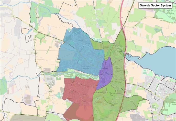
South Fingal
Transport Study
Final Report

               Identification Table
               Client/Project owner   Fingal County Council
               Project                South Fingal Transport Study
               Type of document       Final Report
               Date                   11/02/19
               Reference number       IE01T17A43
               Number of pages        80

               Approval
               Version      Name            Position                 Date                 Modifications
               1            Author          Seán Kearns              Associate Director   22/11/2018
                            Checked by      Alison Pickett           Associate Director   11/01/2019
                            Approved by     Ian Byrne                Business Director    15/01/2019
South Fingal Transport Study

Contents
1 | Introduction                                    6   5 | Swords Transport
1.1   Background                                    6        Assessment                                     31
1.2   Scope and Expected Outcomes                   7   5.1   Overview                                        31
1.3   Key Policies                                  7   5.2   Existing Population and Travel Review           32
1.4   Report Structure                              9   5.3   Swords Land Use Forecasts                       33
1.5   SFTS Sub-Reports                              9   5.4   Network Analysis and Recommendations            35
                                                        5.5   Swords Recommendations Summary                  39

2 | Study Approach                                 10   5.6   Swords Recommendations Map (Local)              40
                                                        5.7   Swords Recommendations Map (Full Area)          41
2.1   Overview                                     10
2.2   Land Use Forecasts                           11
2.3   Timeframe                                    11   6 | Fingal/Dublin Fringe
                                                             Transport Assessment 43
3 | National, Regional, Local                           6.1   Overview                                        43

     Policy                   13                        6.2   Existing Population and Travel Review           44
                                                        6.3   Future Land Use Assumptions                     46
3.1   National Planning Framework 2040             14
                                                        6.4   Network Analysis and Recommendations            48
3.2   Strategic Framework for Investment in Land
      Transport (SFILT)                            15   6.5   Fingal/Dublin Fringe Recommendations
                                                              Summary                                         54
3.3   Smarter Travel Policy                        15
                                                        6.6   Fingal/Dublin Fringe Recommendations Map        55
3.4   Draft Regional Spatial and Economic
      Strategy (RSES)                       16
3.5   NTA Transport Strategy for Greater Dublin
      Area 2016–2035                             17
                                                        7 | Dublin Airport Transport
3.6   Spatial Planning and National Roads
                                                             Assessment              57
      Guidelines, DECLG/DTTaS 2012          22          7.1   Overview                                        57
3.7   Fingal Development Plan 2017-2023            22   7.2   Existing Surface Access and Transport
3.8   Design Manual for Urban Roads and Streets    25         Facilities                             58

3.9   Permeability: A Best Practice Guide 		            7.3   Travel Characteristics of Staff and Passengers 62
      (NTA, 2015)                           26          7.4   Future Demand Assumptions                       64
                                                        7.5   Future Network Analysis and
                                                              Recommendations               65
4 | Study Area Overview                            27   7.6   Key Dublin Airport Surface Access
4.1   South Fingal Area                            27         Recommendations                                 70
4.2   Swords                                       28   7.7   Dublin Airport Surface Access
                                                              Recommendations Map             72
4.3   Fingal/Dublin City Fringe                    29
4.4   Dublin Airport                               30
                                                        8 | Conclusion &
                                                             Recommendations                                73
                                                        8.1   Conclusion                                      73
                                                        8.2   SFTS Summary Recommendations List               76

                                                                                                                     3
Figures
    Figure 1.   Overall Study Approach                 12    Figure 22. Summary of POWSCAR Work and
    Figure 2.   Policy Framework                       13               School Trips Combined        45

    Figure 3.   MetroLink Alignment                    19    Figure 23. Locations of New Housing Units per
                                                                        CSA in the Clongriffin Area         46
    Figure 4.   Bus Connects CBCs North Dublin         20
                                                             Figure 24. Extract of Fingal Development Plan in
    Figure 5.   South Fingal Proposed NTA Cycle 		                      Fingal South                           46
                Network                          21
                                                             Figure 25. Fingal/Dublin Fringe Population
    Figure 6.   Core strategy map for Fingal County    23               Projections                       47
    Figure 7.   Fingal Development Plan Housing Unit         Figure 26. Fingal/Dublin Fringe Employment
                Allocation                             25               Projections                      47
    Figure 8.   Map of the Study Area                  27    Figure 27. Road Alignments Considered               50
    Figure 9.   Swords Transport Network and Growth          Figure 28. Clarehall Junction Relief Road Scheme    51
                Areas                                  28
                                                             Figure 29. Journey Time from Fingal / Dublin
    Figure 10. Fingal / Dublin City Fringe Growth 		                    Fringe to Airport                  52
               Areas and Transport Links           29
                                                             Figure 30. Vehicular AM Journey Times with/
    Figure 11. Dublin Airport Location Map             30               without R107 Bypass              53
    Figure 12. Swords Sectors                          31    Figure 31. Fingal/Dublin Fringe Area
    Figure 13. Swords POWSCAR Commuter 		                               Recommendations             55
               Destinations and Mode Shares 33               Figure 32. AADT at M1 Airport Spur                  58
    Figure 14. Swords POWSCAR School Destinations 		         Figure 33. Short-Term Air Passenger Car Parks       60
               and Mode Shares                     33
                                                             Figure 34. Air Passenger Surface Access Mode
    Figure 15. Population Growth Map – Recognised                       Shares                             62
               Housing                                 34
                                                             Figure 35. Dublin Airport Employee Mode Share       62
    Figure 16. Employment Growth Map                   34
                                                             Figure 36. POWSCAR Analysis of Dublin Airport
    Figure 17. Swords Short Term Recommendations 		                     workers                             63
               Map (Local)                        40
                                                             Figure 37. Dublin Airport Passenger Projections
    Figure 18. Swords Short Term Recommendations 		                     2017 – 2046                           64
               Map (Full Area)                    41
                                                             Figure 38. Figure 38. AM Peak Period (7-10am)
    Figure 19. Fingal/Dublin Fringe Sectors            43               Trips Generated to Airport          66
    Figure 20. Fingal/Dublin Fringe POWSCAR Commuter         Figure 39. Dublin Airport Surface Access Short
               Destinations and Mode Shares          45                 Term Recommendations                 72
    Figure 21. Fingal/Dublin Fringe POWSCAR School
               Destinations and Mode Shares            45

    Tables
    Table 1.    Main Towns by Settlement Type in Fingal 23   Table 7.   Fingal/Dublin Fringe Population and
    Table 2.    Swords Strengths and Planned 		                         Employment by Sector                     44
                Development                    24            Table 8.   Fingal/Dublin Fringe Population and
    Table 3.    Baldoyle Strengths and Planned                          Employment Projection Summary            48
                Development                            24    Table 9.   Fingal/Dublin Fringe Growth Areas
    Table 4.    Portmarnock Strengths and Planned                       Summary by Housing Units           48
                Development                            24    Table 10. Car Parking Provision at Dublin Airport   61
    Table 5.    Balgriffin and Belcamp Strengths and         Table 11. Estimated MetroLink Patronage at
                Planned Development                    24              Dublin Airport Station – 38mppa   66
    Table 6.    Swords Population and Employment by
                Sector                                 32

4
South Fingal Transport Study

Abbreviations
AADT      Average Annual Daily Traffic
CSO       Central Statistics Office
CJRR      Clarehall Junction Relief Road
CBC       Core Bus Corridor
DECLG     Department of Environment, Community and Local Government
DTTAs     Department of Transport, Tourism and Sport
DMURS     Design Manual for Urban Roads and Streets
DAA       Dublin Airport Authority
DART      Dublin Area Rapid Transit
DCC       Dublin City Council
ERM       East Regional Model
EWLR      East West Link Road
EMRA      Eastern and Midlands Regional Assembly
EU        European Union
FCC       Fingal County Council
FDP       Fingal Development Plan 2017-2023
GDA       Greater Dublin Area
GTC       Ground Transportation Centre
ITS       Intelligent Transport Systems
LAPs      Local Area Plans
MASP      Metropolitan Area Strategic Plan
mppa      Million passengers per annum
MSCP      Multi-storey Car Parks
NDP       National Development Plan
NPF       National Planning Framework
NTA       National Transport Authority
POWSCAR   Place of Work and School Census of Anonymised Records
RSES      Regional Spatial and Economic Strategy
SFTS      South Fingal Transport Study
sqm       Square Meter
SDRA      Strategic Development and Regeneration Area
SFILT     Strategic Framework for Investment in Land Transport
SWDR      Swords Western Distributor Road
SWRR      Swords Western Relief Road
NCPF      the National Cycle Policy Framework
TEN-T     Trans-European Transport Network
TII       Transport Infrastructure Ireland

                                                                                                     5
1 | Introduction

    1.1 Background

    In September 2017, Fingal County Council (FCC) commissioned SYSTRA Ltd. to undertake
    the South Fingal Transport Study (SFTS). The SFTS is a study of the transport network in
    South Fingal recommending key transport infrastructure and outline levels of land use
    development that will enable its sustainable growth leading up to the delivery of MetroLink
    and beyond. As such, some of the key questions that the SFTS seeks to address are:
    }} What are the most critical road, public transport and   }} What are sustainable ways of improving Fingal’s
       active travel schemes that Fingal should implement         integration and connectivity with Dublin City?
       in the next decade?                                     }} What measures should Fingal County implement
    }} What infrastructure is required to meet demand in          to ensure the strategic function of Dublin Airport is
       advance of MetroLink?                                      maintained and protected for the future?

6
South Fingal Transport Study

1.2 Scope and Expected Outcomes

The need for the SFTS was identified in the Fingal Development Plan 2017-2023 (FDP) in
objective MT07, which states:
                                                              }} Managing sustainable growth of Fingal’s population
   “Objective MT07: Carry out a comprehensive                    and employment in line with the FDP core strategy
   feasibility study of the South Fingal area to                 and various Local Area Plans (LAPs); and
   produce a strategic ‘vision’ and overall strategy          }} Transport and land use integration, considering
   for the proper planning and sustainable                       where investment in transport supply should be
   development of the study area, based on                       prioritised to meet the short and longer term needs
   a sustainable transport and smarter travel                    driven by ongoing growth in Fingal and adjacent
   approach, planning for all transport modes                    areas, including projected increases in passengers
   and needs, whilst also being reflective of road               using Dublin Airport.
   network capacity and modal split assumptions.
                                                              The scope of the SFTS is to determine the key
   This will be carried out within two years of
                                                              infrastructure measures required within Fingal and
   adoption of the Development Plan and will be
                                                              adjacent areas to tackle existing constraints in transport
   used to inform the preparation of statutory
                                                              capacity, identify appropriate levels of development to
   Local Area Plans and Masterplans in the area.
                                                              facilitate growth in population and employment, and
   The preparation of the study will include
                                                              encourage sustainable travel in the county and wider
   implementation recommendations and will
                                                              region.
   involve: Consultation with key statutory
   stakeholders including TII and the NTA, public             The methodology for the SFTS consisted of analysis of
   consultation and engagement with relevant                  existing population and travel patterns (Census 2016),
   statutory bodies.”                                         development of population and employment forecasts
                                                              for the study area and analysis of future network
                                                              operation using strategic transport modelling. The
Further to the above, the SFTS takes cognisance of the        geographic scope of the SFTS broadly follows the main
need to address the following critical issues as set out in   areas of anticipated growth in the southern part of the
the FDP:                                                      county. These are in Swords, in Fingal/Dublin Fringe
                                                              (e.g. the area stretching from Baldoyle to Clonshaugh
}} Implementing its transport related objectives, linked      including adjacent Dublin City Council areas such as
   to national and regional policy and specifically the       Clongriffin and Belmayne), and in and around Dublin
   objectives of the NTA Transport Strategy for the           Airport. Each of these three broad areas has their own
   Greater Dublin Area 2016-2035;                             particular transport requirements and constraints and
}} Identifying the critical additional road and public        are as such examined in detail separately in this report.
   transport connectivity and capacity required to
   enable the sustainable development of the county,
   supported by integrated proposals for active travel;

1.3 Key Policies

The policy drivers influencing the SFTS are numerous and wide ranging, and include:
}} National Planning Framework (NPF) and the                  }} A Strategic Framework for Investment In Land
   National Development Plan (NDP). The NPF sets                 Transport (SFILT). This framework policy sets out
   out several strategic outcomes that Government                the importance of transport investment to economic
   is committed to delivering by 2040. Both Compact              growth and the principles which frame future
   Growth and Sustainable Mobility objectives are of             investment in transport. It underlines the need to
   particular relevance to the SFTS.                             move away from car-based growth by investing in
                                                                 sustainable travel and improving spatial planning to
                                                                 make sustainable travel options more cost-effective.

                                                                                                                             7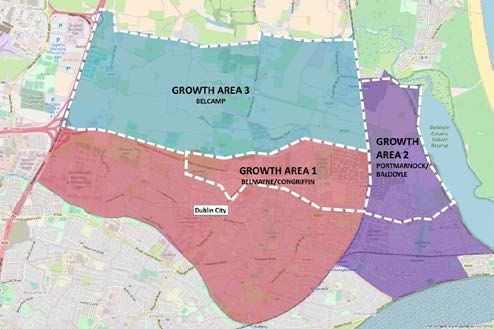
}} Smarter Travel Policy (2009–2020). This is a range         with investment programmes in other sectors, it is
       of polices focussed on reducing the use of the             an essential component for the orderly development
       private car to help ensure a more sustainable future.      of the Greater Dublin Area over the next 20 years.
       It recognises that recent trends in transport towards   }} DoECLG Spatial Planning and National Roads
       increasing car use will damage the economy and             Guidelines for Planning Authorities. These
       society as a whole in the long term.                       guidelines seek to protect the carrying capacity,
    }} NTA Transport Strategy for the Greater                     operational efficiency, safety and ongoing
       Dublin Area 2016-2035. This Strategy provides              investment in national roads. This in particular
       a framework for the planning and delivery of               includes M50 demand management and protection
       transport infrastructure and services in the Greater       of the accessibility of gateway facilities for goods
       Dublin Area (GDA) and provides transport planning          and services for international, national, and regional
       policy around which other agencies involved in land        connectivity.
       use planning, environmental protection, and delivery    More detail on the relevant aspects of each of the
       of other infrastructure (such as housing, water and     above policies is presented in Chapter 3.
       power) can align their investment priorities. Along

8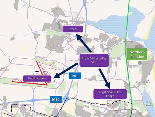
South Fingal Transport Study

1.4 Report Structure

This report presents the main findings of the SFTS and is organised as follows:

Chapter 1: Introduction                                   Chapter 5: Swords Transport Assessment
This chapter provides background the study, its           This chapter follows the approach described in Chapter
overarching objectives and expected outcomes,             2 to set out the land use assumptions and transport
and introduces the key policies which guide the           recommendations for Swords.
recommendations.
                                                          Chapter 6: Fingal/Dublin Fringe Transport
Chapter 2: Study Approach                                 Assessment
This chapter explains the study approach applied to       This chapter follows the approach described in Chapter
each of the three sub-areas, covering approaches          2 to set out the land use assumptions and transport
to the review of existing travel and transport            recommendations for the Fingal/Dublin Fringe area.
conditions, future land use assumptions, and transport
recommendations arising from the analysis of future       Chapter 7: Dublin Airport Transport
transport conditions based on transport modelling.
                                                          Assessment
The transport modelling methodology using the East
Regional Model is summarised in this chapter and          This chapter follows the approach described in
presented in more detail in the technical note SFTS       Chapter 2 to set out the transport / surface access
Transport Modelling Approach.                             recommendations for the Airport.

Chapter 3: Policy Review                                  Chapter 8: Conclusions and
This chapter introduces the relevant policy drivers and
                                                          Recommendations
guidelines from National, Regional, and Local Policy      Conclusions of the study and a summary of the
which form the basis for the SFTS.                        recommendations set out in chapters five to seven are
                                                          provided in this chapter.
Chapter 4: Study Area Overview
This chapter provides an overview of the three areas
focussed on by the study: Swords, Fingal/Dublin City
Fringe, and Dublin Airport.

1.5 SFTS Sub-Reports

This report is based on the following detailed area specific studies:
}} Swords Study. This technical report focusses           }} Dublin Airport Surface Access Issues Paper.
   on Swords and uses a range of population and              This technical report on surface access to Dublin
   employment data, in combination with transport            Airport was developed as part of the wider SFTS.
   modelling, to examine issues and recommend                It considers broad issues relating to current and
   improvements to the transport networks.                   future surface access at Dublin Airport in addition to
}} Fingal/Dublin Fringe Study. This technical report         forecasting future effects on the transport network
   focusses on the Fingal/Dublin Fringe area and uses        of continued passenger and employment growth
   a range of population and employment data, in             using transport modelling.
   combination with transport modelling, to examine       }} SFTS Transport Modelling Report. This report
   issues and recommend improvements to the                  provides a detailed description of the modelling
   transport networks.                                       software used, the inputs, scenarios and
                                                             assumptions applied and the key outputs used to
                                                             inform study recommendations.

                                                                                                                         9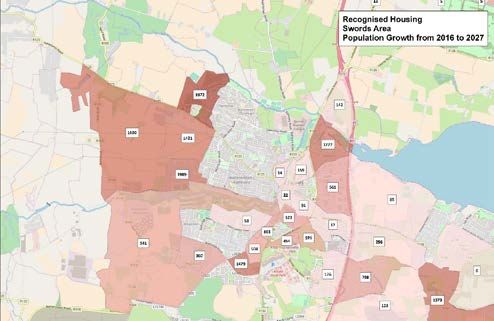
2 | Study Approach

     2.1 Overview

     The South Fingal Transport Study (SFTS) was developed using the following key elements.

     2.1.1 Policy Review and                                          2.1.4 Future Land Use, Travel
           Stakeholder Consultation                                         Behaviour and Network
     The aim of this task was to review relevant policy                     Evaluation
     drivers and the existing transport supply context to
                                                                      FCC and DCC planners were consulted to determine
     establish the basis for setting the objectives of the
                                                                      potential levels of population and employment in zones
     SFTS. It included initial stakeholder engagement with
                                                                      within the study area. This was based on an inventory
     the National Transport Authority (NTA), Transport
                                                                      of planning permissions and development potential
     Infrastructure Ireland (TII), Dublin City Council (DCC) and
                                                                      for various areas. An initial forecast of population and
     Dublin Airport Authority (DAA) to establish the various
                                                                      employment in Fingal was provided by the main NTA
     goals and challenges for the county.
                                                                      reference case year of 2035. These data sets form the
     This task also involved developing a thorough                    basis for the modelling of a potential future land-use
     understanding of the range of previous transport                 situation with respect to development of the area.
     schemes, studies and background policy documents.
                                                                      For modelling future transport networks in the ERM, a
                                                                      range of transport schemes for both road and public
     2.1.2 NTA Regional Modelling                                     transport were identified through a review of the NTA
                                                                      GDA Strategy, the FDP and various LAPs and were
           System                                                     then input to the ERM. Examples of schemes include
     This element of the study involved preparing the inputs          elements of the GDA Strategy such as the Core Bus
     and data extraction processes required to run and                Corridors and MetroLink, in addition to a range of road
     interpret the NTA’s East Regional Model (ERM). This              proposals as outlined in previous FDPs.
     included network coding of various road and public
     transport schemes and the preparation of planning                Mitigation measures were then identified to address
     data inputs to the overall models. The NTA forecast              specific issues highlighted from the modelling results
     land use data for 2035 provided the starting point for           (e.g. over capacity public transport services or
     the development of forecasts for the SFTS. The use of            congested roads and junctions), to generally improve
     the ERM is covered in detail in the separate technical           the performance of both the public transport and
     note SFTS Transport Modelling Approach.                          road networks and enable sustainable travel choices.
                                                                      The analysis of POWSCAR in combination with the
                                                                      strategic modelling provides further rationale for the
     2.1.3 Baseline Travel Behaviour                                  recommendations associated with walking and cycling
           and Network Evaluation                                     improvement. This was an iterative process, whereby
                                                                      mitigation measures were used to generate new
     This task informed the identification of constraints and         transport schemes, which were then re-assessed in the
     opportunities and formed a basis for the development             ERM. A series of workshops with FCC, DCC, NTA, and
     of the key recommendations of the study. It focussed             TII were undertaken to further develop options and
     on quantifying existing travel behaviour and transport           solutions. The process is described in Figure 1.
     network operation using Census 2016 POWSCAR1, the
     National Household Travel Survey, and the 2016 ERM
     transport model.

     1        Place of Work and School Census of Anonymised Records

10
South Fingal Transport Study
2.2 Land Use Forecasts
The forecasts assumed in this study with respect to population and employment levels
in South Fingal, and the modelled effects on the transport network, will inform future
decisions on planning in Fingal County but should not be regarded as targets or as maxima
or minima on future development permissible in a location.
In some cases the forecasts presented would a recommendation or study outcome. In such areas
constitute a highly intense level of development. reasonable and sustainable development levels may be
Such forecasts are used in the modelling to ascertain different. The appropriate level would be subject to a
impacts on transport but should not be regarded as more detailed feasibility assessment at LAP stage.
2.3 Timeframe
The SFTS focusses on a 2027 timeframe for the following reasons:
}} Fingal is the fastest growing county in Ireland and of growth in patronage at Dublin Airport on the
needs to provide for increased travel demand in the transport network and to identify the key surface
short term; access constraints that are expected to arise in
}} There is an immediate need to prioritise projects advance of MetroLink;
that relieve congestion at identified pressure points }} While MetroLink and Bus Connects will deliver
and improve the facilities available for walking and step changes in the quality and capacity of public
cycling; transport, these schemes are not expected to be
}} There is a need to consider now how the rapidly fully complete and operational until at least 2027.
developing Fingal/Dublin Fringe area can be better The SFTS fills an important gap in determining the
integrated and connected with Dublin Airport and interventions required for the ongoing development
northern parts of Dublin without over reliance on of the county and adjacent areas; and
M50 access; }} It corresponds with the life-time of the FDP and
}} There is an immediate need to consider the impact associated LAPs and Masterplans, and hence the
anticipated level of housing provision up to 2027.
11Figure 1. Overall Study Approach
Existing (Observed) Travel Behaviour Review Policy Review and Stakeholder Consultation
Input from Key Agencies
National Policy
Census Small Area Population and National Transport
Population Statistics Employment Review Authority
Regional Policy Transport
Baseline Trip
Infrastructure Ireland
Generation and
Mode Share Dublin City Council
Analysis City/County Policy
Dublin Airport
Census Place of Work Authority
Census of Anonymised Travel Pattern Review
Records Local Policy
Existing and Future Situation Transport Modelling Network Analysis and Transport
Recommendation Development
NTA Regional
Future Land Use Modelling System Road and Public Analyse road and public
Local Area Plans, Transport Flows, transport networks for
Housing Inventory, etc. Delays, Capacities, over-capacity issues
National Demand etc.
Forecasting Model
Trip Generation and Identify Opportunities
Mode Share for Constraints on the
Future Transport East Regional various public networks
Schemes transport and road
Model
NTA GDA Strategy scenarios
Fingal Development Plan
Emissions, Identify Policy Led
Schemes, etc. Appraisal
Derived Transport Environment, Transport Mitigations
(optional) Economic Appraisal
Proposals
FEEDBACK
Test in Transport Models
ACCEPTANCE
South Fingal Transport Recommendations
12South Fingal Transport Study
3 | National, Regional, Local Policy
The policy requirements for the SFTS are numerous and wide ranging. This chapter reviews
the most relevant elements of each policy/plan to the SFTS. Figure 2 summarises the most
critical policies, guidelines and plans that underpin the SFTS recommendations.
Figure 2. Policy Framework
National Level
Policy / Plans Guidance
• National Planning Framework – Ireland, Our Plan • DoECLG Spatial Planning and National Roads
2040 (Department of Housing, Planning and Local Guidelines for Planning Authorities
Government; 2017) • Sustainable residential development in urban
• National Transport Authority Mission and areas
Objectives • Urban Design Manual: Best Practice Guide
• Smarter Travel: A Sustainable Transport Future; • Design Manual for Urban Roads and Streets
2009-2020 • Permeability: Best Practice Guide
• A Strategic Framework for Investment In Land • Achieving Effective Workplace Plans: Guidelines
Transport (SFILT) for Local Authorities
Regional Level Policy
• Eastern Regional Planning Guidelines (superseded by below)
• DRAFT Eastern and Midlands Regional Spatial and Economic Strategies (RSES)
• Metropolitan Area Strategic Plan (MASP)
City / County / Metro Level Policy and Plans
• NTA Transport Strategy for the Greater Dublin Area (2016-2035)
• NTA Greater Dublin Area Cycle Network Plan
• Fingal Development Plan (2017-2023)
• Dublin City Development Plan (2016 – 2022)
• South Fingal Transport Study (AECOM 2012)
Local Level Policy and Plans
• Your Swords: An Emerging Strategic Vision
• A range of LAPs and Masterplans including but not limited to:
• 2006 Dublin Airport LAP
• Dublin Airport Central Masterplan
• Oldtown/Mooretown LAP
• Clongriffin/Belmayne LAP
• Baldoyle-Stapolin LAP
133.1 National Planning Framework 2040
The National Planning Framework (NPF) is the Government’s high-level strategic plan for
shaping the future growth and development of our country out to the year 2040. Key
objectives from the recently published NPF include:
}} Guide the future development of Ireland in order }} Regional concentration towards cities and potential
to accommodate the projected one million increase for some regionally important larger settlements;
in our population, the need to create 600,000 }} A focus on contained growth and reduced sprawl
additional full time jobs and the need to build by targeting infill lands, some of which will be
550,000 more homes by 2040; brownfield sites in existing built-up areas; and
}} Reduce the distances between places of work and }} Sequential provision of infrastructure with some
homes in order to reduce current unsustainable strategic investment outcomes identified.
trends of increased commuting, aiming to ensure
With respect to Fingal, the future key enablers for
most people have no more than a 30-minute
growth outlined in the NPF are the following:
commute from home to work;
}} To secure more compact forms of urban }} Delivering key rail projects including MetroLink and
development in all types of settlement; Dart Expansion;
}} To regenerate rural Ireland by promoting }} Development of a better bus system with better
environmentally sustainable growth patterns; orbital connectivity and integration with other
}} To plan and implement a better distribution of transport networks;
regional growth, in terms of jobs and prosperity; }} Delivery of the metropolitan cycle network;
}} To transform settlements of all sizes through }} Relocating some land uses to outside the M50 from
imaginative urban regeneration and bring life and existing built up areas; and
jobs back into cities, towns and villages; and }} Improving access to Dublin Airport – including
}} To co-ordinate the delivery of infrastructure and improved public transport access, connections
services in tandem with growth. from the road network and in the longer-term
It also outlines the preferred approach to ‘macro-spatial’ consideration of heavy rail access to facilitate direct
growth which is characterised as: services from the rail network in the context of
potential future electrification.
}} One with regional parity for the East Midlands
Regional Area in relation to the North West Regional
Area and the South Regional Area;
14South Fingal Transport Study
3.2 Strategic Framework for Investment in Land
Transport (SFILT)
A first priority for SFILT is the steady state maintenance of the existing land transport
infrastructure and services in the Greater Dublin Area. This will involve expenditure on
maintenance and renewal in order to keep the existing transport system in an adequate
condition, and ensure sufficient operating and management expenditure to continue to
deliver adequate transport services.
The next priority is to address urban congestion and Major new roads are generally not advocated by
improve the efficiency and sustainability of the urban the SFILT framework as part of as the solution to
transport system in the GDA and Fingal County. The congestion, although capacity enhancements to existing
focus will be improved and expanded public transport roads coupled with demand management measures
capacity, improved and expanded walking and cycling can be justified in limited circumstances, as is the case
infrastructure, and the use of Intelligent Transport for the SFTS.
Systems (ITS) to improve efficiency and sustainability.
3.3 Smarter Travel Policy
Objectives of this National Government policy include:
}} Addressing the current unsustainable transport }} Improve accessibility to transport and improve
and travel patterns and to reducing the health and quality of life with an emphasis on people with
environment impacts of current trends; reduced mobility and those experiencing isolation as
}} Delivering a sustainable transport system in line a result of a lack of transport.
with climate change targets; The keys goals of the policy are to be achieved by the
}} Reducing work related commuting by car from a following four main actions:
current modal share of 65% down to 45% by 2020;
}} Reducing distances travelled by car and encourage
and
usage of smarter travel by focusing development,
}} Increasing commuting by alternative sustainable population and employment growth in the same
modes to 55% by 2020. areas and actively encourage people to reside near
The document outlines five key goals necessary for places of work and use fiscal measures in order to
achieving sustainability in transport. These are: illicit behavioural change;
}} Increasing availability of alternatives to the car,
}} Reduce overall travel demand and commuting
centred around a radical improvement in public
distances travelled by car;
transport services and increasing investment in
}} Improve economic competitiveness through other modes of active transport such as walking and
maximising the efficiency of the transport network cycling;
and alleviating congestion and infrastructure
}} Improving the efficiency of motorised transport such
bottlenecks;
as improved fleet structure, energy efficiency and
}} Reduce reliance on fossil fuels and thus improve alternative technologies; and
security of energy supply;
}} Strengthening of institutional arrangements.
}} Minimise the negative impacts of transport on
the local and global environment by reducing air
pollutants and greenhouse gas emissions attributed
to travel; and
153.4 Draft Regional Spatial and Economic Strategy
(RSES)
The draft Eastern and Midlands Regional Assembly (EMRA) RSES supports continued
population and economic growth in Dublin City and suburbs, with high quality new housing
promoted and a focus on the role of good urban design, brownfield redevelopment and
urban renewal and regeneration. It promotes improvement in the provision of public
transport and active travel and the development of strategic amenities to provide for
sustainable communities.
The RSES identifies Swords, Maynooth and Bray as of measures to co-ordinate investment and decision
important in a regional and county context. They are making across multiple stakeholders;
noted to have the capacity and future growth potential }} Facilitate the creation of a new street fronting the
to accommodate above average growth in the region river walk to the west of Main Street and support
with the requisite investment in employment creation, co-ordinated infill development on key strategic sites
services, amenities and sustainable transport. along Main Street and North Street; and
}} Promote core recreational and amenity spaces,
Relevant objectives of the draft RSES include:
utilising in particular Ward River Valley Park, Swords
RPO 4.24: Support the continued development of Cultural Quarter including Town Park, Ward River
Swords as part of an emerging ‘Green City’ concept, Walk west of Main Street area.
building on its strategic location near Dublin Airport and The draft RSES provides further basis for the integration
linked to the delivery of MetroLink to provide for high of land use and transport planning in the region,
density and people intensive uses in locations that are informing the preparation and implementation of
accessible to quality public transport nodes, existing plans, programmes and projects at all levels. To
and planned. achieve this in the EMRA, Local Authorities the NTA and
other agencies will seek to apply the following guiding
RPO 4.25: Future development required to achieve the
principles in statutory land use plans:
growth vision for Swords shall:
}} For urban-generated development, the development
}} Support the regeneration of underused, vacant or
of lands within or contiguous with existing urban
derelict town centre lands for residential/mixed use
areas should be prioritised over development in
development to facilitate population growth;
less accessible locations. Residential development
}} Provide for the sustainable, compact and sequential
should be prioritised in lands (including infill and
infill of yet-to-be developed Masterplan and Local
brownfield sites) which are or will be most accessible
Area Plan zoned lands along the R132 and future
by walking, cycling and public transport;
MetroLink corridor; and
}} The predicted impact of the potential land use
}} Require the preparation of a Local Area Plan at
and transport infrastructure on modal split and
Lissenhall to inform policy for the longer-term
transport greenhouse gas emissions should be
strategic area of Swords, in accordance with Your
assessed to deliver on national and regional targets;
Swords: An Emerging City Strategic Vision 2035 or
}} Large trip intensive developments, such as high
any update thereof.
employee dense offices and retail, should in the first
RPO 4.26: Facilitate the strategic regeneration of instance be focussed into central urban locations;
Swords to increase the resilience of the local economy }} Within the Dublin Metropolitan Area, except in
and provide for an enhanced urban environment with a limited planned circumstances, trip intensive
particular focus on the following key objectives: developments or significant levels of development
}} Enhance the identity of the town centre through the should not occur in locations not well served by
development of Swords Civic Centre and Cultural existing or proposed high capacity public transport;
Centre, the delivery of the conservation plan for }} The strategic transport function of national roads
Swords Castle, and the delivery of an enhanced and associated junctions should be maintained and
public realm in Swords Town Centre, in accordance protected; and
with a new healthy placemaking strategy to provide }} All non-residential development proposals should
a prioritised, programmed and impactful package be subject to maximum parking standards.
16South Fingal Transport Study
3.5 NTA Transport Strategy for Greater Dublin Area
2016–2035
3.5.1 National Transport Authority Mission and Objectives
The following outlines the NTA’s vision, mission and relevant priorities and objectives as set
out in the NTA Statement of Strategy 2018 – 2022:
3.5.2 NTA GDA Strategy 2016-2035
NTA Vision:
The NTA GDA Strategy is based on a set of core
“To provide high quality, accessible,
principles that provide the framework for the planning
sustainable public transport connecting
and delivery of infrastructure and services in the GDA
people across Ireland.”
up to 2035. These are:
}} As the capital city of Ireland and a major European
According to the document, in order to deliver this centre, Dublin shall grow and progress, competing
vision, the NTA will: with other cities in the EU, and serving a wide range
of international, national, regional and local needs;
}} Secure the provision of an efficient, accessible and
}} The Dublin and Mid-East Regions will be attractive,
integrated transport system in rural and urban
vibrant locations for industry, commerce, recreation
Ireland;
and tourism and will be a major focus for economic
}} Transform and elevate customers’ transport growth within the Country;
experience;
}} The GDA, through its ports and airport connections
}} Regulate privately operated transport services for will continue to be the most important entry/exit
the benefit of consumers; point for the country as a whole, the European
}} Contribute to the effective integration of transport Union and the rest of the World. Access to and
and land use policies; and through the GDA will continue to be a matter of
}} Advance Ireland’s transition to a low emissions national importance;
transport system. }} Development in the GDA shall be directly related
The following top three priorities in the NTA’s strategy to investment in integrated quality public transport
are of relevance to the SFTS: services and focussed on compact urban form;
}} Development within the existing urban footprint
}} Priority 1: Undertake strategic transport planning of the Metropolitan Area will be consolidated to
seeking the optimal alignment of land use and achieve a more compact urban form; and
transport policy and practice, enabling an increased
}} Development in the Hinterland Area will be focussed
proportion of travel by sustainable modes;
on consolidation of development in key identified
}} Priority 2: Promote the use of more sustainable towns, separated from each other by extensive
modes of transport; and areas of strategic green belt land devoted to
}} Priority 3: In line with available funding, agriculture and similar uses.
implement an effective infrastructure investment
programme that delivers sustainable and public
transport infrastructure in a cost effective manner,
complemented by appropriate traffic and demand
management measures.
In order to help deliver the NTA’s policy goals, and to
enable the delivery of appropriate levels of transport
investment in Fingal, the SFTS aligns with the above
vision and priorities.
17To achieve these principles future development must: 3.5.4 MetroLink
}} Integrate land use and transport to reduce the need
to travel, the distance travelled, the time taken to
travel, and to promote walking and cycling especially
within development plans;
}} Protect the capacity of the strategic road network;
The MetroLink project, shown in Figure 3, is the
}} Ensure a significant reduction in share of trips taken development of a north-south urban railway service
by car, especially those trips which are shorter or that will run along a high-demand corridor between
commuter trips; Swords and Sandyford, connecting key destinations
}} Take into account all day travel demand from all including Dublin Airport and the City Centre along
groups; and its 26km route. There will be a total of 25 stations
}} Provide alternative transport modes to reduce strain (including 15 new stations), 3,000 additional Park
on the M50, as the current increase in traffic is and Ride spaces and a journey time of approximately
unsustainable. 50 minutes from Swords to Sandyford. Four of its
Within the strategy significant investment is planned stations are in Swords. From south to north these are
for Fingal and the corridor connecting Fingal and Dublin Fosterstown, Swords Central, Seatown, and Estuary.
City Centre, including: The latter will include a Park and Ride.
}} MetroLink; NTA/TII have concluded the public consultation process
at the time of writing this report. A “Preferred Route”
}} DART Expansion Programme, which proposes the
for the scheme will be published in 2019, on which the
provision of high frequency DART services on the
public will again be invited to submit their views. The
existing Northern rail line;
Preferred Route will then proceed to planning and it is
}} Two Core Bus Corridors, one linking Swords and anticipated that a Railway Order Application to An Bord
the Airport to the City Centre and the other linking Pleanála will be made in Q3 2019.
Clongriffin along the Malahide Road to the City
Centre;
}} Construction of a distributor road to the west of
Swords;
}} Extension and improvement in cycling
infrastructure; and
}} Development of strategic park and ride facilities at
Swords.
3.5.3 National Development Plan
2018-2027
There are a number of key transport infrastructure
measures proposed by the NTA GDA Transport
Strategy which now form a part of the NDP 2018–2027.
These include DART Expansion, MetroLink, Luas and
Bus Connects. These schemes, which will support
the delivery of an environmentally sustainable low-
carbon public transport system, will ensure that public
transport meets the significant growth in passenger
demand for public transport services in the Eastern and
Midlands Region by 2040.
18South Fingal Transport Study
Figure 3. MetroLink Alignment
Donabate
Lanistown
New Dairy Lane Seafield
Estuary
METROLINK ROUTE MAP Swords Seatown
Knocksedan
SWORDS – SANDYFORD
Swords Central Malahide
Fosterstown
MetroLink Route
Forrest Great Sea Mount
Future Station
Park & Ride
Ward
Rail Cloghran Feltrim
Saint Margaret’s
Luas – Red Line
Dublin Airport
Luas – Green Line Dublin Airport
Kinsealey
Portmarnock
Saint Doolaghs
Williamsville
Dardistown Woodlands
M50 Belcamp Balgriffin
Clongriffin
Northwood Belmayne
Cappoge
Santry
Donaghmede
Abbotstown Ballymun Baldoyle
Finglas Coolock
Collins Avenue
Kilbarrack
Dunsink Beaumont
Whitehall Artane
Glasnevin Raheny
Griffith Park
Castleknock Killester
Drumcondra Marino Dollymount
Cabra
Glasnevin
Fairview
Clontarf
Mater
Phoenix Park
O’Connell Street
Stoneybatter
Islandbridge
Smithfield
Chapelizod Tara
Ballyfermot The Liberties Ringsend
Kilmainham
Inchicore St. Stephen’s Green
Irishtown
Rialto
Bluebell Portobello Charlemont Sandymount
Dolphin's Barn
Rathmines Ballsbridge
Drimnagh Ranelagh
Harold's Cross
Walkinstown Beechwood
Crumlin
Cowper
Kimmage Rathgar
Terenure Milltown Booterstown
Perrystown
Clonskeagh
Windy Arbour Blackrock
Rathfarnham
Templeogue
Churchtown Dundrum Mount Merrion Monkstown
Dún Laoghaire
Balally Stillorgan
Ballyroan
Knocklyon Kilmacud
Firhouse Ballyboden Stillorgan
Figure 1: Route Map Ballinteer Sandyford Deans Grange
Whitechurch Sallynoggin
Sandyford
4 Foxrock
Killiney
Rockbrook
Cabinteely
Latest MetroLink Route from City Centre Ballyogan
193.5.5 DART Expansion and Greystones. The capacity increase of the Drogheda
line under the DART Expansion programme will support
The DART Expansion Programme is a series of growth in eastern parts of the Fingal Area.
projects that will create a linked and interconnected
metropolitan area DART network for Dublin. Initial
investment will deliver the non-underground tunnel 3.5.6 Bus Connects and Core Bus
elements of the programme using the recently opened Corridor Project
rail link and existing connector tunnel under the
Phoenix Park. This includes buying additional fleet for In advance of the MetroLink being constructed, it will be
the DART network and measures such as re-signalling, necessary to provide a higher level of public transport
junction and station changes to provide expanded capacity on the corridor linking Swords and the Airport
services. The next stage will be to provide fast, high- to the city centre. This will take the form of a Core Bus
frequency electrified services to Drogheda on the Corridor (CBC) type upgrade along the route. The final
Northern Line, Celbridge/Hazelhatch on the Kildare arrangement would be designed to be complementary
Line, Maynooth and the M3 Parkway on the Maynooth/ to the MetroLink project.
Sligo Line. DART services will continue to be provided A CBC along the Malahide Road to Clongriffin will also
on the South-Eastern Line as far as Greystones. New be provided as a means of upgrading the existing bus
stations to provide interchange with bus, Luas and corridor to provide for additional demand not readily
Metro networks will be included. served by DART at locations such as Belcamp, Balgriffin,
This integrated rail network will provide a core, high- Belmayne, Donnycarney, Artane, Coolock and Darndale.
capacity transit system for the region and will deliver a Figure 4 illustrates the CBCs proposed to serve North
very substantial increase in peak-hour capacity on all Dublin as part of Bus Connects.
lines from Drogheda, Maynooth, Celbridge/Hazelhatch
Figure 4. Bus Connects CBCs North Dublin
20South Fingal Transport Study
3.5.7 Road Network in parts. In Fingal, the report documents how the
cycling provision within the county is poor, with limited
The NTA GDA Strategy includes a distributor road on cycling facilities in urban and rural areas.
the western side of Swords, in addition to a distributor
road around Donabate. These are required to provide As part of a planned additional 2340km expansion of
for development access and to address congestion cycle routes in the GDA, some of the proposed routes in
issues in the general localities. The Strategy further Fingal include:
identifies the intersection of the Malahide Road with
the east-west R139 at Balgriffin/Clare Hall (the Clarehall }} Primary radial cycle route (Route 1A) reaching
Junction) as a major source of delay on both routes and Baldoyle, Portmarnock and Malahide;
notes the requirement for road proposals to address }} Primary radial cycle route (Route 2A) reaching
these deficiencies. Swords;
}} Radial Route 3B – extension from Finglas Village
along St Margaret’s Road from Finglas Road to
3.5.8 Greater Dublin Area Cycle Charlestown; and
Network Plan }} A comprehensive and integrated network of cycle
Based upon the National Cycle Policy Framework routes within Swords.
(NCPF), the plan outlines the present situation of the
Figure 5 below shows an extract of the Plan’s proposed
existing cycle route network and its relatively low usage
network in South Fingal.
Figure 5. South Fingal Proposed NTA Cycle Network
213.6 Spatial Planning and National Roads Guidelines,
DECLG/DTTaS 2012
These guidelines set out planning policy considerations relating to development
affecting national primary and secondary roads, including motorways and associated
junctions, outside the 50-60 kph speed limit zones for cities, towns and villages. The SFTS
complements these guidelines by seeking to protect the capacity and safety of the national
road network in the study area.
3.7 Fingal Development Plan 2017-2023
The Fingal Development Plan 2017-2023 (FDP) outlines the Council’s objectives, policies and
vision for the long term development of the County as an integrated network of vibrant and
socially and economically successful settlements and communities. The plan emphasises
the importance of sustainable transport to the future economic, social and physical
development of Fingal.
The main aims of the FDP relating to transport and land New housing is to be provided by consolidating existing
use planning include: zoned lands and maximising the efficient use of existing
and proposed infrastructure. This is to help ensure
}} To protect and improve the quality of the built and that land use and transport strategy is in line with the
natural environment; current National and Regional policies. A target of
}} To ensure the provision of adequate housing, nearly 40,000 new units is set out across a range of
necessary infrastructure and community facilities; settlements in Fingal as part of the Fingal Settlement
}} To incorporate sustainable development, climate Strategy.
change mitigation, social inclusion, high quality
This strategy, illustrated in Figure 6, sets out to
design and resilience as fundamental principles;
physically consolidate the majority of future growth in
}} To develop a hierarchy of high quality, vibrant urban strong and dynamic urban centres in the metropolitan
centres favouring expansion in areas nearest to area, whilst directing development in the hinterland to
existing or planned public transport nodes; towns and villages to discourage dispersed settlement
}} To ensure an adequate supply of zoned lands to and unsustainable travel patterns. Land has been zoned
meet forecasted and anticipated economic and to accommodate future anticipated population growth
social needs, while avoiding an oversupply which through a mix of varied house types and size in areas
would lead to fragmented development, dissipated equipped with good public transport links. Growth
infrastructural provision and urban sprawl; will be managed in accordance with the overarching
}} To promote and facilitate movement to, from and hierarchy of settlement centres as set out in the table
within Fingal, by integrating land use with a high below.
quality, sustainable transport system that prioritises
walking, cycling and public transport;
}} To provide an appropriate level of safe road
infrastructure and traffic management, in particular
to support commercial and industrial activity and
new development; and
}} To work with all relevant stakeholders to seek
a reduction in greenhouse gas emissions from
transport.
22South Fingal Transport Study
Table 1. Main Towns by Settlement Type in Fingal
Metropolitan Area Hinterland Area
Metropolitan Moderate Sustainable Large Growth – Level 2 Other Hinterland
Consolidation Town Growth Towns Balbriggan Towns/Villages
Swords Donabate Balrothery
Moderate Sustainable
Blanchardstown Malahide Loughshinny
Growth & Other Towns
Consolidation Areas Small Town Lusk Villages
Within Gateway Portrane Rush Ballyboghi
Baldoyle Skerries Naul
Villages
Castleknock Balscadden
Coolquay
Clonsilla Oldtown
Kinsaley
Howth Garristown
Rivermeade
Baskin Ballymadun
Rowlestown
Mulhuddart Village
Portmarnock
Sutton
Santry (Incl. Ballymun)
Balgriffin & Belcamp
Charlestown & Meakstown
Figure 6. Core strategy map for Fingal County
23Table 2 to Table 5 below summarise the significant the FDP for some of its key metropolitan towns and
strengths and planned development identified in consolidation areas.
Table 2. Swords Strengths and Planned Development
Strengths Planned Development
}} Level 2 Major Town Centre }} Promote Swords as Fingal’s primary growth centre for
}} Access to Dublin-Belfast economic corridor and residential development and a multimodal transport
to high quality regional road network (R125 and hub
R132) }} Facilitation of sufficient employment, retail, community
}} Close proximity to Dublin Airport and cultural facilities to serve Swords
}} Strong industrial base }} MetroLink
}} Important centre for employment in the County }} Bus priority from West Swords into Main Street
Baldoyle, Portmarnock, Balgriffin and Belcamp are continued consolidation, with future development
identified as consolidation towns. The policy in these to occur in a planned, efficient manner utilising
areas seeks to ensure maximum benefit from existing opportunities to increase density.
transport, community and social infrastructure through
Table 3. Baldoyle Strengths and Planned Development
Strengths Planned Development
}} Range of urban services with the capacity to meet }} Baldoyle Public Transport Bridge
the needs of existing and expanding populations }} Baldoyle Link road
}} Maintain greenbelt land
}} Facilitated improvements to pedestrian access to
Howth junction station and bus stops
}} Preparation of a Local Plan for the area
Table 4. Portmarnock Strengths and Planned Development
Strengths Planned Development
}} Linked to Dublin-Belfast commuter railway }} Implementation of an Urban Centre Strategy and a
Public Realm Strategy
}} Use of greenbelts to protect the character of the town
}} Enhance the rail station and rail service and improve
facilities for cyclists, provision of feeder buses and
improve pedestrian and cycling linkage between
Chapel Lane and the station
}} Prepare and implement a local plan for the strategic
development of the area
Table 5. Balgriffin and Belcamp Strengths and Planned Development
Strengths Planned Development
}} Potential for integration with Clongriffin / }} Prepare a local plan for Belcamp to provide a
Belmayne sustainable mixed use urban district with the
}} Proximity to future Core Bus Corridors necessary infrastructure
}} Ensuring all new communities are built with accessible
local services
}} Promoting green infrastructure linkages
24South Fingal Transport Study
3.7.1 Housing Allocation Summary
A summary of the FDP’s housing unit allocations is ‘Headroom’ allocation relates to potential housing
presented graphically in Figure 7, categorised by at Lissenhall (north of Swords). The ‘Other’ category
Consolidation Town, Consolidation Area, Moderate includes Balgriffin and Belcamp, amongst other smaller
Sustainable Growth Town, and Headroom. The sites around the county.
a Figure 7. Fingal Development Plan Housing Unit Allocation
m of Units
Residential Allocation by Area FCDP to 2023
Blanchardstown
11757
Swords
8828
Lissenhall
7000 Small Towns 877 Other 2791
Donabate 4056 Portmarnock 1490
Malahide 1114
Howth 498
Consolidation Towns Baldoyle/Sutton 1498
Headroom
Moderate Sustainable
Growth Consolidation Areas
pe
3.8 Design Manual for Urban Roads and Streets
The Design Manual for Urban Roads and Streets (DMURS) is a mandatory strategy used by
Local Authorities which sets out design standards for urban roads and streets. It balances
the place function (the needs of residents and visitors) and the transport function (the
needs of pedestrians, cyclists, public transport, cars and goods vehicles).
By utilising DMURS, the end goal is that well-designed principles set out in DMURS apply to the design of all
streets are placed at the heart of sustainable urban roads and streets where the speed limit is 60kph
communities to promote access to walking, cycling or less.
and public transport. The standards, approaches and
25DMURS recognises the importance of creating secure }} Multi-functional Streets – place based streets
and connected places that work for all, characterised which balance the needs of all users in self-
by creating new and existing streets as attractive places regulating environment;
which prioritise access from pedestrians and cyclists }} Pedestrian Focus – the quality of street
whilst also balancing appropriate vehicular access and environment is measured by the quality of the
movement. pedestrian environment. Pedestrians and cyclists
are the preferred users; and
The following four DMURS principles help to achieve a
more place-based and integrated approach to road and }} Multi-disciplinary Approach – greater co-operation
street design. These are: between design professionals and a plan-led
approach to design.
}} Connected Networks – high levels of permeability
and legibility for all, with an emphasis on more
sustainable forms of transport;
3.9 Permeability: A Best Practice Guide (NTA, 2015)
Permeability: A Best Practice Guide sets out guidance on how best to facilitate demand for
walking and cycling in existing built-up areas. The scope extends to linkages for people to
walk and cycle from their homes to shops, schools, local services, places of work and public
transport stops and stations.
Permeability is defined as the extent to which an urban }} Absence of high walls and fences segregating
area permits the movement of people by walking or housing areas and local/district centres;
cycling. Characteristics of a permeable environment }} Absence of cul-de-sacs for pedestrians and cyclists;
are: and
}} Interconnected pedestrian and cycle street }} Secure, well-lit, overlooked pedestrian and cycle
networks; links between housing areas and between housing
and local/district centres.
26South Fingal Transport Study
4 | Study Area Overview
4.1 South Fingal Area
The SFTS study area is presented in Figure 8 and covers the main areas of anticipated
growth in South Fingal. These areas include Swords, Fingal/Dublin Fringe – the area
stretching from Baldoyle to Clonshaugh including adjacent Dublin City Council areas such
as Clongriffin and Belmayne – and in and around Dublin Airport. Each of these three broad
areas has their own unique transport requirements and constraints and are discussed
separately within this report.
An overview of the three key areas examined by the SFTS is presented below.
Figure 8. Map of the Study Area
274.2 Swords
Swords is a large town situated 14km north of Dublin City at the fringe of its metropolitan
area. A new Metro line is to be built by 2027 linking Swords, the Airport, and Dublin City
Centre with connections to the rail network. The strategic vision for Swords is to continue
to grow into a sustainable new city with a population of 100,000 (“Your Swords, An
Emerging City, Strategic Vision 2035, Fingal County Council 2008). The town’s population
was 43,000 according to the most recent 2016 Census; 6,000 more than the Census of
2011, making Swords one of the largest and fastest growing towns in Ireland. The Airport
is just 4km to the south along the R132. Census data suggests that of the Airports’ 12,000
workers, 2,000 live in Swords.
Housing in Swords is predominantly situated to the the overall Dublin City region can be accommodated in
west of the town, typically in the form of semi-detached such outer suburban metropolitan locations. Swords
estates, arranged along several former rural roads such is highlighted in the NPF because the delivery of
as Rathbeale Road, Brackenstown Road and Forest MetroLink will enable significant and sustainable non-
Road. In contrast to its housing orientated western car dependant growth.
areas, eastern Swords includes a diverse range of
residential and commercial land uses along the Main The development of Swords is also guided by the
Street, the R132, and along the edges of the M1. Main Swords Emerging City Vision 2035 and the Swords Town
Street retains a vibrant character and provides a broad Centre Masterplan (2009), which emphasise Main Street
mix of shops, bars and restaurants. There is a mix as the future centre of Swords with strong links to the
of low density housing and a large shopping centre MetroLink corridor. The Local Area Plan (LAP) areas
between Main Street and the R132. Light industrial within the town boundary are illustrated in Figure 9.
uses occupy the western side of the Ward River just
north of Main Street. Figure 9. Swords Transport Network and Growth
Areas
The strategic road network is predominantly orientated
on a north-south axis, due to Swords’ historical Estuary West
Estuary
development along the Dublin-Belfast road (R132), Central
which has now been superseded by the M1. Various Oldtown- Estuary
business and retail parks are located along the R132, Mooretown East
such as Airside and Swords Business Park. Formerly the
Rathbeale Road
R132 served as a by-pass of Swords on the old Dublin-
Belfast Road. The R132 has since become an integral
part of Swords’ urban fabric, and functions as a local
traffic distributor for the town’s population to access Brackenstown Road Main St
places of work and commerce.
Forest Road
Barryspark
Swords is identified as a Metropolitan Consolidation
town in the FDP. It has an important role as both Rathingle
a developing town in the Dublin region, and as the Fosterstown Crowscastle
main County Town in Fingal. It is identified in the
National Planning Framework (NPF) as an example of a
Metropolitan location which can significantly grow with
urban expansion or sustainable infill development. The
NPF states that up to 20% of the growth targeted for
28You can also read