UC Santa Barbara GIScience 2021 Short Paper Proceedings - eScholarship
←
→
Page content transcription
If your browser does not render page correctly, please read the page content below
UC Santa Barbara
GIScience 2021 Short Paper Proceedings

Title
The Virtual Reality of GIScience

Permalink
https://escholarship.org/uc/item/3wz9104b

Authors
Peek, Amber
Martin, Michael
Kolston, Sophie

Publication Date
2021-09-01

DOI
10.25436/E2J015

Peer reviewed

 eScholarship.org                           Powered by the California Digital Library
                                                            University of California
The Virtual Reality of GIScience
Amber Peek1         !
University of Auckland, New Zealand
Michael Martin         !Ï
University of Auckland, New Zealand
Sophie Kolston        !Ï
University of Auckland, New Zealand

        Abstract
Virtual reality technology has the potential to be a revolutionary addition to the field of Geographic
Information Science. The application of virtual reality to GIScience has been discussed for decades,
however adoption has been limited until recently. Virtual reality GIScience represents an interdiscip-
linary approach, incorporating fields such as video game development. In this paper, we introduce
Locative Reality, a virtual reality software that presents users with immersive 360° video experiences
of forest environments. It incorporates spatial information into the virtual environment so that data
generated by virtual research can be directly linked to real-world locations. The implications for the
field of GIScience include virtual research tools and educational experiences, accessible to anyone
anywhere in virtual reality.

    1    Introduction
Virtual reality is an increasingly accessible tool with applications to many scientific and
technological disciplines, including GIScience [15, 19]. It provides a truly three-dimensional
experience, rather than the common two-dimensional or 2.5-dimensional faux-3D view [20].
Virtual reality is also highly interactive – three-dimensional programs can be explored much
like real-world space. This is an immersive form of GIScience, with the potential to enhance
techniques such as participatory GIS using this immersivity [23]. GIScience can incorporate
virtual reality through existing geospatial methods and those from other fields.

    2    Review of Foundations
Virtual reality within GIScience has been discussed for decades. In the 1990s Couclelis
[7] and Faust [10] reviewed the then-current state of GIScience and the potential impacts
of virtual reality technology on the field. Examining the past discourse on virtual reality
GIScience from a modern perspective enables a situated understanding of the current state
of this ever-developing discipline.

2.1      Couclelis, 1992: People manipulate objects (but cultivate fields)
Couclelis’ [7] discussion on the vector-raster debate within traditional GIScience has implica-
tions today, even when the two data types are both widely supported and used. Many of

1
    Corresponding author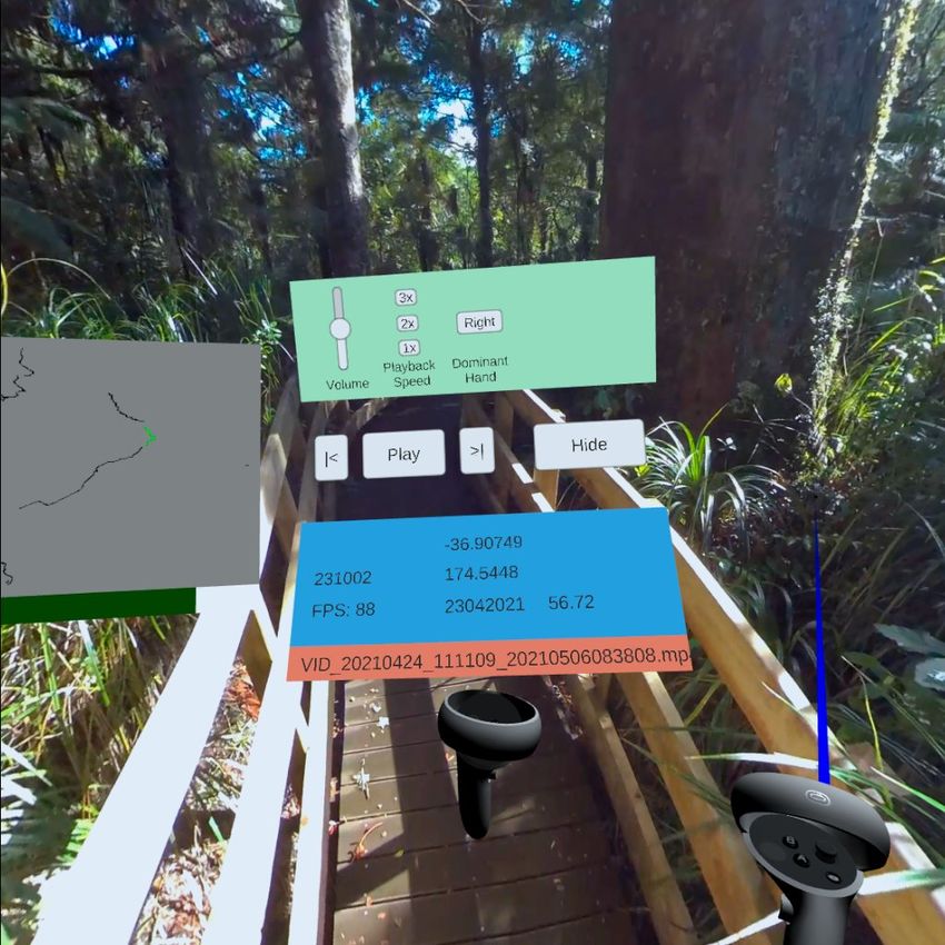
2   The Virtual Reality of GIScience

    Couclelis’ desiderata for the “next but one” generation of GIScience are addressed by the
    integration of virtual reality.
        Couclelis’ desiderata describe the ability for GIScientists to use the system and data format
    that best suits their study purpose. Virtual reality addresses this through the combination
    of vector and raster datasets, depending on the program [28]. Couclelis suggests that vector
    data should be used for objects, while raster data should be used for fields, or areas. An
    example of this is the ‘skybox’, typically a 360° panoramic raster projected onto a sphere,
    used to show the more distant areas of the game world [28].
        Couclelis’ final desideratum considers that “the most significant geographic spaces may
    never make it into a computer”. The coverage of locations ranging from the Grand Canyon
    to individual houses on platforms such as Google Street View or in Microsoft Flight Simulator
    (2020) [22] shows how detailed and accessible geographic information has become in the
    decades since Couclelis’ writing.
        Many of Couclelis’ desiderata for GIScience are addressed with the introduction of virtual
    reality technology. By Couclelis’ criteria, this shows that virtual reality presents a step
    forward in the development of GIScience as a whole.

    2.2     Faust, 1995: The virtual reality of GIS
    Faust [10] examines the then-emerging field of virtual reality GIScience in the mid-1990s.
    Like Couclelis [7], Faust lists several criteria for the creation of a “truly interactive three-
    dimensional virtual reality GIS”.
        Firstly, Faust stresses that the depiction of the three dimensions of real geographic places
    must be realistic [10]. Released in the same year as Faust’s writing, the Nintendo Virtual Boy
    was the first publicly available stereoscopic video game console [29]. The display resolution
    was 384×224 pixels in monochromatic red, using mirror-directed LED light [29]. In contrast,
    the Oculus Quest 2, a current consumer virtual reality headset, has a resolution of 1832×1920
    RGB pixels for each eye [9]. As virtual reality technology improves over time, Faust’s vision
    of a highly realistic virtual environment will be achieved to a greater standard.
        Faust’s [10] second criterion is the free movement of the user. Six degree of freedom
    (DOF) tracking is common among current virtual reality headsets. It allows rotation on
    the x, y, and z axes (3DOF), as well as movement along all three axes (6DOF) [6]. The
    Nintendo Virtual Boy of Faust’s time had effectively zero degrees of freedom [29]. Modern
    virtual reality headsets, including the Oculus Quest 2 [9], use 6DOF head tracking, often
    combined with controller, hand, or body tracking to give an immersive virtual experience
    where the user has free movement as they would in real life.
        Generally, Faust’s [10] criteria have been addressed, or continue to be addressed, through
    technological developments in the decades following their writing.

    2.2.1     Technology-Driven GIScience Milestones
    Virtual reality GIScience also has roots in Al Gore’s Digital Earth speech [11]. Gore, like
    Couclelis [7], outlines necessary developments in technology to create a near-complete virtual
    Earth. The complexity of nature requires computational power to codify, and large amounts
    of digital storage to record [11]. Physical frameworks, such as data storage and high-speed
    Internet [11], and software frameworks such as Virtual Reality Modelling Language (VRML)
    allow for realistic representations of the real world. VRML allows web browsers to display
    three-dimensional models [13]. Notably, this provides an easily-accessible platform for three-
    dimensional GIScience to be performed [13], where users can more intuitively understand
A. Peek and M. Martin and S. Kolston 3
the spatial phenomena they are viewing. Modern software such as ESRI’s ArcGIS 360 VR is
an example [16]. Virtual reality presents a next step in this intuitive GIScience approach,
moving from a three-dimensional model displayed on a flat screen to a truly three-dimensional
environment that they can explore.
The aims put forward by Faust for virtual reality GIScience show the state of virtual
reality technology in the 1990s, and how far the field has developed in the last 30 years. This
technology development has facilitated high-fidelity representations of real space in virtual
worlds, in manners following those outlined by Gore [11]. Many of both Faust’s [10] and
Couclelis’ [7] desiderata have been addressed through the integration of virtual reality into
GIScience, enabled by technological improvements including frameworks such as VRML.
3 GIScience Methods
Virtual reality is currently being applied to GIScience in a number of ways. Remote sensing
techniques, notably LiDAR, are being employed to generate three-dimensional models for
virtual reality [3]. Additionally, structure-from-motion (SFM) methods, a form of stereo
photogrammetry, can be used to create these environments [17].
LiDAR is an increasingly accessible technology. Consumer-grade electronics, such as
the iPhone 12 Pro [2], have built-in LiDAR scanners that can produce three-dimensional
models of objects. Models used in virtual reality are made of polygons, structured similarly
to the triangular irregular networks (TINs) used in GIScience. The LiDAR technology often
used to generate TIN digital elevation models [1] can be used to create other 3D models of
real-world objects and places [3]. LiDAR can effectively model complex natural structures
such as tree crowns [18] or rocky outcrops [4], especially when combined with high-resolution
360° imagery [19]. LiDAR, an established GIScience technology, has applications in virtual
reality environment generation, enabling highly realistic renditions of real places.
Photogrammetry is another GIScience method applicable to virtual reality [24]. Stereo
photogrammetry can be utilised to construct three-dimensional models from multiple still
images taken from different vantage points. This technology, used in ‘structure-from-motion’
(SFM) techniques, can be applied to 360° video that has corresponding location information
[15]. SFM can create highly detailed replications of real-world environments without the
need to design models manually. Virtual reality using stereo photogrammetry has been
demonstrated [17], however its uptake remains limited. SFM could provide virtual access to
even the most inaccessible places around the world.
The combination of both LiDAR and SFM techniques presents a toolkit for highly accurate
3D modelling of natural areas. Each method is best suited for different scales and structures
[15]. When combined they can be an effective three-dimensional terrain modelling system
for use in virtual reality.
4 Non-GIScience Methods
The use of software not traditionally associated with GIScience in the field of GIScience
is becoming ever more prevalent. The modelling and animation software Blender is being
used to generate three-dimensional models based on geospatial data, for example [25]. A key
source of digital infrastructure being used in virtual reality development, including within
GIScience, is video game engines. Unity and Unreal Engine are the most commonly used
engines for video games and scientific programs [27].
Video game engines provide tools for the development of virtual reality programs, with4 The Virtual Reality of GIScience
support for devices from multiple manufacturers. Unity, launched in 2005 [27], uses the C#
scripting language and is known for its user-friendliness [26]. Unreal Engine was originally
released in 1998 [26], with Unreal Engine 5 releasing in 2022 [8]. It has state-of-the-art polygon
rendering (known as Nanite) and dynamic lighting (Lumen). Both engines have real-time
graphics rendering capabilities, however Unreal Engine is considered to have better-looking
visuals and more support for complex structures such as foliage [26].
Video game engines also fill a niche for environmental scientists. Unity’s physics engine
has been used to simulate rockfall at various sites globally [12]. These simulations were
able to predict real-world rockfall scenarios. The physics simulation capabilities of Unity
add functionality to GIScience that is not provided in GIS-focused programs. This added
functionality is provided not through necessitating development of new software but through
the embracing of technologies external to GIScience and acknowledging the importance of
interdisciplinary approaches.
5 Locative Reality
Locative Reality is a virtual reality program developed by the Spatial Innovation Lab at
the University of Auckland, New Zealand. It features an immersive virtual environment
designed primarily for interview-based research. Locative Reality is built with Unity for
Oculus hardware, integrating 360° video and audio with GPS location data to generate
spatial information.
The environment in Locative Reality is presently created using recordings created with the
Insta360 Pro 2 camera. Locative Reality uses 360° video in 8K resolution, with accompanying
spatial audio and GPS data [14]. This is well suited for current studies involving forest
environments, which contain fine details such as tree leaves, requiring a high resolution to
capture. The video is projected onto the inside of a sphere placed around the user’s head,
and the location data is used to ensure travel in the game space can be related back to the
real world.
Locative Reality’s user interface has several parts. Attached to the user’s left hand is
a map and graphical controls similar to a media player. The map shows the GPS tracks
of each video segment, allowing the user to better understand where they are in real-world
space. A progress bar shows the user how far along in each video they are and supports
skipping back and forward in the video. There are additional point-and-click video player
controls, shown in Figure 1.
(a) The basic interface. (b) The expanded controls. (c) During an annotation.
Figure 1 Screenshots of the user interface of Locative Reality while the user is in a video
experience.A. Peek and M. Martin and S. Kolston 5
The critical part of Locative Reality is the ability to create audio annotations to the
virtual experience using the built-in microphone of the headset, shown in Figure 1c. Where
the user was looking and their position in real-world space is also recorded in GeoJSON
format. This spatial information is markedly more detailed than that generated from in-
person go-along interviews, for example [5], with the added benefits of accessibility that
virtual reality provides [21].
Locative Reality combines GIScience and virtual reality to create a medium for generating
geospatial information from virtual environments. Its current use is for research interviews,
both for studying the technology itself and for studying experiences within the virtual
environment. The virtual reality aspect increases accessibility, reducing factors such as
disability or environmental restrictions. The future of GIScience using virtual reality is being
created today with applications such as Locative Reality.
6 Conclusion
Virtual reality provides new ways of seeing and exploring the world in a highly accessible
manner. As the technology is readily available in consumer markets, does not need expert
knowledge to operate, and can display locations that would otherwise be inaccessible to the
users, it is a thriving area. Applying virtual reality to GIScience, as in Locative Reality,
represents an acknowledgement of interdisciplinary thinking, where users can take advantage
of methods and technologies originating in other fields. Virtual reality provides resolutions
to many of the desiderata presented by Couclelis [7] and Faust [10] in the 1990s, enabled by
technological developments highlighted by Gore [11], a mere 30 years later.
References
1 Tarig Ali and Ali Mehrabian. A novel computational paradigm for creating a Triangular Irreg-
ular Network (TIN) from LiDAR data. Nonlinear Analysis: Theory, Methods & Applications,
71(12):e624–e629, 2009. doi:10.1016/j.na.2008.11.081.
2 Apple Inc. iPhone 12 Pro. URL: https://www.apple.com/iphone-12-pro/specs/.
3 Yusuf Arayici. An approach for real world data modelling with the 3D terrestrial laser
scanner for built environment. Automation in Construction, 16(6):816–829, 2007. doi:
10.1016/j.autcon.2007.02.008.
4 Florence Bonnaffe, Dave Jennette, and John Andrews. A method for acquiring and processing
ground-based lidar data in difficult-to-access outcrops for use in three-dimensional, virtual-
reality models. Geosphere, 3(6):501–510, 2007. doi:10.1130/GES00104.1.
5 Richard M Carpiano. Come take a walk with me: The “go-along” interview as a novel method
for studying the implications of place for health and well-being. Health & place, 15(1):263–272,
2009. doi:10.1016/j.healthplace.2008.05.003.
6 Yang-Wai Chow. Low-cost multiple degrees-of-freedom optical tracking for 3D interaction in
head-mounted display virtual reality. International Journal of Recent Trends in Engineering,
1(1):12–16, 2009. doi:10.1.1.592.6330.
7 Helen Couclelis. People manipulate objects (but cultivate fields): beyond the raster-vector
debate in GIS. In Theories and methods of spatio-temporal reasoning in geographic space,
pages 65–77. Springer, 1992. doi:10.1007/3-540-55966-3_3.
8 Epic Games. Unreal Engine 5 early access, 2021. URL: https://www.unrealengine.com/
en-US/unreal-engine-5.
9 Facebook Technologies, LLC. Oculus device specifications. URL: https://developer.oculus.
com/learn/oculus-device-specs/.
10 Nickolas L Faust. The virtual reality of GIS. Environment and Planning B: Planning and
Design, 22(3):257–268, 1995. doi:10.1068/b220257.6 The Virtual Reality of GIScience
11 Al Gore. The Digital Earth: Understanding our planet in the 21st Century, 1998.
12 Rob Harrap, Jean Hutchinson, Zac Sala, Matt Ondercin, and Paul-Mark Difrancesco. Our
GIS is a game engine: Bringing Unity to spatial simulation of rockfalls. In GeoComputation
2019. The University of Auckland, 2019.
13 Bo Huang and Hui Lin. GeoVR: A web-based tool for virtual reality presentation from 2D
GIS data. Computers & Geosciences, 25(10):1167–1175, 1999. doi:10.1016/S0098-3004(99)
00073-4.
14 Insta360. Insta 360 Pro 2 - 360 VR Camera | 8K 360 Professional | 3D. URL: https:
//www.insta360.com/product/insta360-pro2/.
15 Margaret Kalacska, J Pablo Arroyo-Mora, and Oliver Lucanus. Comparing UAS LiDAR
and Structure-from-Motion Photogrammetry for peatland mapping and virtual reality (VR)
visualization. Drones, 5(2):36, 2021. doi:10.3390/drones5020036.
16 Ming-Chun Lee. Emerging Trends in Geospatial Technologies for Study of Urban Landscape.
Landscape Research Record, 7.
17 Ta-Te Lin, Yuan-Kai Hsiung, Guo-Long Hong, Hung-Kuo Chang, and Fu-Ming Lu. Develop-
ment of a virtual reality GIS using stereo vision. Computers and Electronics in Agriculture,
63(1):38–48, 2008. doi:10.1016/j.compag.2008.01.017.
18 Haijian Liu and Changshan Wu. Developing a scene-based triangulated irregular network
(TIN) technique for individual tree crown reconstruction with LiDAR data. Forests, 11(1):28,
2020. doi:10.3390/f11010028.
19 Giovanni Mastrorocco, Riccardo Salvini, and Claudio Vanneschi. Fracture mapping in chal-
lenging environment: A 3d virtual reality approach combining terrestrial LiDAR and high
definition images. Bulletin of Engineering Geology and the Environment, 77(2):691–707, 2018.
doi:10.1007/s10064-017-1030-7.
20 Peter E Morse, Anya M Reading, and Tobias Stal. Exploratory volumetric deep earth
visualization by 2.5d interactive compositing. IEEE Transactions on Visualization and
Computer Graphics, 2020. doi:10.1109/TVCG.2020.3037226.
21 Meltem Altinay Ozdemir. Virtual reality (VR) and augmented reality (AR) technologies for
accessibility and marketing in the tourism industry. In ICT Tools and Applications for Accessible
Tourism, pages 277–301. IGI Global, 2021. doi:10.4018/978-1-7998-6428-8.ch013.
22 Mark Pesce. When games get real-[internet of everything]. IEEE Spectrum, 57(11):23, 2020.
doi:10.1109/MSPEC.2020.9262153.
23 Irene Pleizier, Ron van Lammeren, Henk Scholten, and Rob van der Velde. Using virtual reality
as information tool in spatial planning, 2004. URL: https://library.wur.nl/WebQuery/
wurpubs/fulltext/30054.
24 Cristina Portalés, José Luis Lerma, and Santiago Navarro. Augmented reality and photo-
grammetry: A synergy to visualize physical and virtual city environments. ISPRS Journal of
Photogrammetry and Remote Sensing, 65(1):134–142, 2010. doi:10.1016/j.isprsjprs.2009.
10.001.
25 Andrea Scianna. Building 3D GIS data models using open source software. Applied Geomatics,
5(2):119–132, 2013. doi:10.1007/s12518-013-0099-3.
26 Antonín Šmíd. Comparison of Unity and Unreal Engine. Czech Technical University in Prague,
pages 41–61, 2017.
27 Sesha Sai Kaushik Upadhyayula. Investigation of battery consumption by using accelerometer
sensor in Android: A comparative study between Unity and Unreal Engine 4, 2020. URL:
https://core.ac.uk/download/pdf/84832291.pdf.
28 Mark JP Wolf. Z-axis development in the video game. In The Video Game Theory Reader 2,
pages 173–190. Routledge, 2008. doi:10.4324/9780203887660-14.
29 Matt Zachara and José P Zagal. Challenges for success in stereo gaming: a Virtual Boy case
study. In Proceedings of the international conference on Advances in Computer Enterntainment
Technology, pages 99–106, 2009. doi:10.1145/1690388.1690406.You can also read