Uncovering the Past An Archaeological Study of Oyster Beds at Emsworth
←
→
Page content transcription
If your browser does not render page correctly, please read the page content below
Uncovering the Past
     An Archaeological Study of Oyster Beds at Emsworth
                                 Project Summary

                                   Julie Satchell

About the Project
The Emsworth oyster beds were part of a system of natural and artificial beds and
pits used to seed, sort and grow oysters. The industry included fleet of dredging
vessels to collect oysters from natural and artificial beds as well as from sources
abroad. The timber remains of the oyster beds are visible on the foreshore at low
tide. Archaeological investigation of these remains was undertaken in 2008. Work
included foreshore survey involving local volunteers and historical research to help
understand the development of the site.

The area surveyed in on the north part of the Emsworth foreshore, Figure one shows
the oyster beds and features overlain on an Ordnance Survey (OS) map dated to
1974. To the south of these features is an area marked ‘Oyster Bed’ which is the
remains of ‘The Ark’ which was also surveyed.

   Figure 1: Emsworth Harbour showing surveyed oyster beds (Based on 1974 OS map)

The History of the Oyster Industry
Maps, photographs and documents provide a range of sources of information on the
Emsworth oyster industry and the use of the oyster pits and ponds. The site has an
interesting development which is related to the oyster trade of the Solent and more
widely across England.

Map and Chart Evidence
The OS maps of the Emsworth area show the extent and arrangement of the oyster
pits from the early 19th century onwards. As these maps are updated relatively
frequently they show a lot of detail on the changes in the oyster beds over time.
Figure 2 shows the OS map from 1866 and is one of the earliest records of the oyster
beds, however, it is likely the oyster beds had been in existence for some time prior
to this.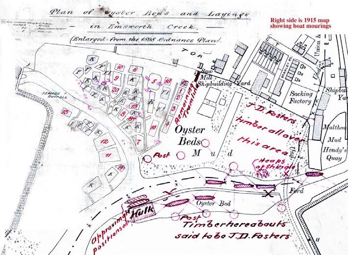
The map from 1909 shows a reduction in the number of oyster beds, which
happened due to an incident of poisoning from Emsworth oysters in 1902. This map,
along with details from a map of 1898, was used to create the ‘Plan of Oyster Bed
and Layings’ (Figure 3) which shows the ownership of the beds in detail.
Figure 2: One of the earliest Ordnance Survey maps of 1866 showing extensive Oyster beds
to the north of the Emsworth foreshore and along the Mill Pond to the west.
Figure 3: The composite ownership and moorings map based on OS maps from 1898 and
1915.
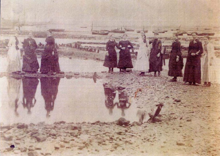
Historical Photographs
Emsworth Museum holds a collection of historic photographs related to the oyster
industry. Many of the photographs show oyster dredging vessels and people involved
in the industry. A few photos show the oyster pits, Figure 5 dates from 1898 and
shows the water filled pits and some of the associated timber structure.
Figure 4: An historical photograph dating to 1898 of the Emsworth oyster pits. The water filled
            pits are well defined and the rough timber lining of the pits is evident.

Documented History
The exploitation of oysters has been long established in Britain. There is evidence
from the prehistoric period that oysters were favoured by prehistoric hunter-
gatherers. However, the first reliable historical reference to large-scale gathering of
oysters is from the Roman period when Sallust writing in Rome around 50BC
remarked: ‘Poor Britons – there is some good in them after all – they produce an
oyster’. Later in 60 AD, Juvenal describes the high repute English oysters held with
the Roman elite (Eyton 1858). These references are backed up by oyster shells
found in Roman villa sites such as Fishbourne and Barton Court Farm (Potter and
Johns 1992). The gathering of oysters at this time is likely to be from natural stocks
rather than from artificial ponds.

There are historical records from the Saxon period, the most significant for the Solent
area is the Domesday Book which records nine fisheries in the area. Oyster beds are
recorded at Bosham, Birdham, Hayling, Cosham and Porchester in the Eastern
harbours, Croften near the Meon estuary, Eling and Dibden on Southampton water
and Stanswood in the West Solent.

By the middle of the fourteenth century there are written references to protected or
leased, and presumably managed, beds at Emsworth, Hayling Island, Wootton
Creek, Newtown Harbour, the Medina estuary and the Beaulieu estuary (Tubbs
1999). From the Medieval period the records provide more detail of the locations and
types of fisheries. An account of 1307 describes Emsworth oysters as famous for
their flavour (Kennet 1985). These sources do not give evidence of how the oysters
were gathered, but it is likely that vessels using rakes or dredges were used.

Written evidence relating to oyster vessels is available from the 16th and 17th
centuries, but these do not reference storage pits for the oysters. The first reference
to oyster pits at Emsworth dates to 1688 (Whitfield 2005, 14). The oyster fishery was
flourishing in the 18th century, an account from 1788 records that twelve fishermen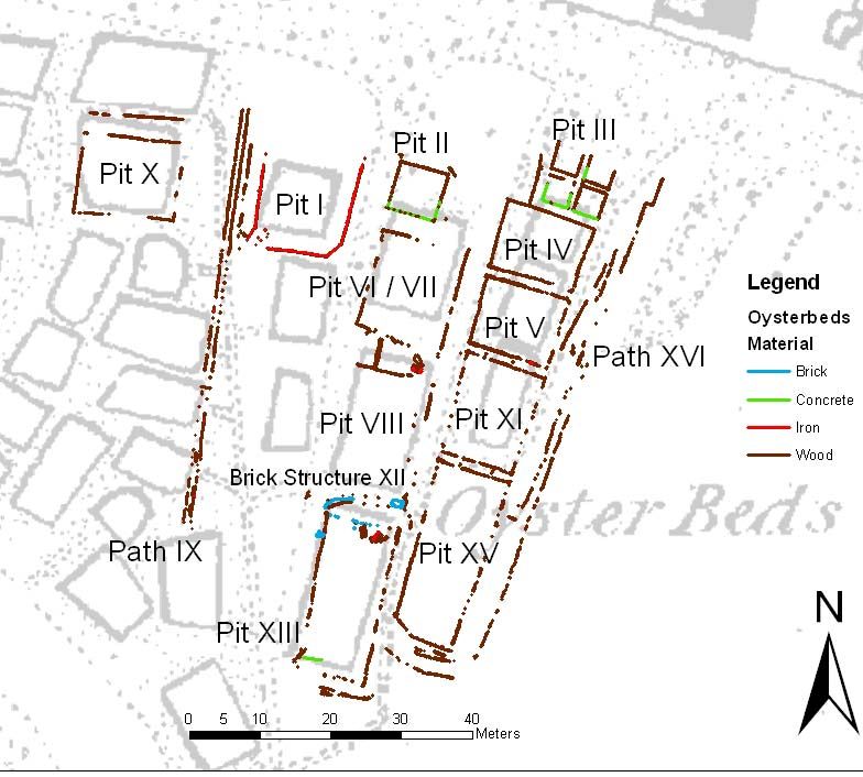
dredged 7.035 bushels of oysters from the harbour (Whitfield, 2003). By the 1830s
high numbers of fishing boats had over fished the natural beds, depleting the stocks.
To help number a closed season was introduced (between May and August) and a
minimum size, but these regulations were widely ignored.

In 1821 the Russell family built a house and oyster beds off Ware Point (known as
Oyster Island). These may have been the first oyster beds in the harbour. During the
early days of the industry many pits were privately owned by fishermen, but by the
late 19th century the Emsworth industry was dominated by two merchants – James
Duncan Foster and John Kennett.

There is a large archive of documentation from J.D Foster’s business, showing him
purchasing oyster pits and an associated merchant businesses. He also developed a
fleet of oyster dredging vessels, between 1885 and 1900 he built 11 oyster fishing
smacks, which were considered the most innovative fishing boats built in the country
at that time. The largest was Echo at 80 tons. Around 40% of Foster’s oysters were
brought to Emsworth for storage in pits, they came from as far away as America,
Portugal, Holland and France as well as Falmouth, Whitstable and the other east
coast ports. The other 60% of oysters were dredged from more local waters.

Disaster struck the Emsworth oyster trade in November 1902. Oysters served at
banquets in Winchester and Southampton caused several guests to fall ill, including
the Dean of Winchester (who had been at both events) who died. Tests showed that
the oysters had been contaminated with typhoid, which poisoned the guests. The
sale of oysters from Emsworth Harbour was banned and the local trade collapsed.

Between the two World Wars the oyster trade began to pick up, but the outbreak of
the 2nd World War meant the oyster pits were not able to be tended. Following the
war the industry did not really recover and was virtually closed by the 1960s. There
was an attempt in the 1980s to revive the industry and in 1985 over 33 tons of
oysters were dredged from Emsworth Harbour and sold for £56,000. However, the
increase of pleasure craft in the harbour meant that pollutants from anti-fouling paint
affected the oysters and the trade finally died.

The Archaeological Remains
The wooden traces of the oyster beds are clearly visible on the foreshore at
Emsworth at low tide. To create an archaeological record of the site a program of
survey was undertaken.

     Figure 5: CDAS and EMHT volunteers recording the oyster pits on the foreshore at
                                     Emsworth.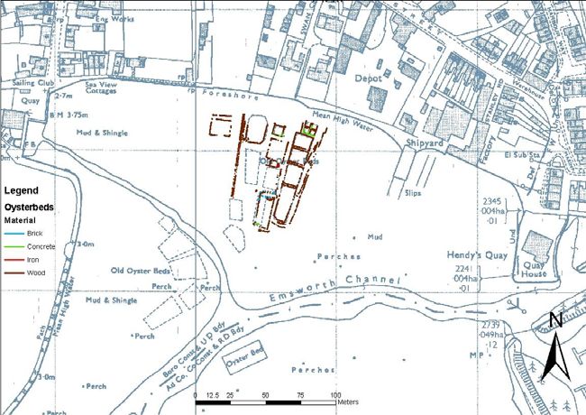
The initial stage of survey involved creating a series of datum points to provide
adequate coverage to allow more detailed survey of the oyster pits and the remains
of the Ark. With the datum grid in place teams of volunteers braved the winter
weather in February to record all the visible remains of the oyster beds. A
photographic record was created of the Ark.

Fieldwork Results
The oyster beds and other features visible on the foreshore were given a number
(presented in Roman numerals). Figure 6 shows a plan of all the surviving features.

Figure 6: Overall Site Plan showing main exposed features including oyster pits and
pathways on the Emsworth foreshore.

Each of the features was recorded by written descriptions, photographs and scale
drawings. There is a full description of each of the individual features within the
detailed project report (this is available from Chichester Harbour Conservancy), a
summary of the results is presented in the table below, with a number of features
described in more detail below the table:

Featu   Name         Description
re
I       Oyster pit   Measures 12m x 15m, no timber structure is visible on northern side.
                     Small channel and timbers in south west corner are likely to be
                     remains of a sluice.
II      Oyster pit   Measures 7m x 7m, made of horizontal planks supported by posts on
                     either side of the planking, fastened with nails. Wood survives on all
                     sides of pit. Pit has a concrete base.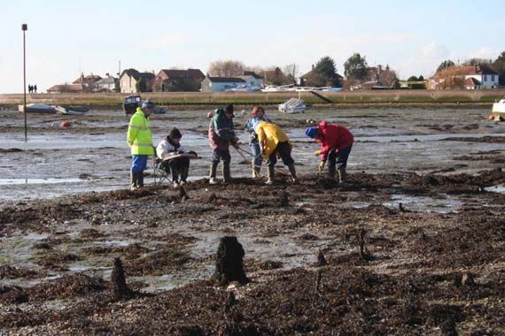
III    Oyster pit     Pond III is divided into four smaller pits with walkways dividing them.
                      Feature measures 8.2 x 8.6m. All four pits have concrete bases with
                      horizontal planking supported by posts making up the edges. Pit IIId is
                      the best preserved, there is little surviving timber on the north sides of
                      IIIa and IIIb.
IV     Oyster pit     Measures 13m x 10m. North side is in good condition, with other sides
                      poorly preserved but visible. Pit has a circular iron fitting that may
                      have been part of a sluice in SW corner.
V      Oyster pit     Measures 12.1m x 9.9m. Different construction to other pits with outer
                      horizontal planking with an inner layer of vertical planks. Best
                      preserved on its western side. Possible sluice remains near SE
                      corner.
VI &   Oyster pit     A single feature rather than two separate ones. Main pit is 15.5m x
VII                   12.4m made of horizontal planking supported by posts. Timber ‘gutter’
                      feature runs to the south of the pit 4m from SW corner running into pit
                      VII.
VIII   Oyster pit     17.6m x 11.2m in size made of horizontal planking with supporting
                      posts, with a few vertical posts. A patch of what appears to be
                      wickerwork was observed on the western side, this could be the
                      remains of parts of the structure or could be a means of consolidating
                      a pathway.
IX     Path           A raised path made of compacted shingle retained by horizontal
                      planks and regularly spaced posts, which runs north-south down the
                      western edge of the exposed pits. Planks boardering the path are 2m
                      long and have been fastened with iron nails. Path alignment does not
                      match the historic OS mapping or the pit edges, it is believed to post-
                      date the oyster beds and may be related to mooring access from
                      1960s.
X      Oyster pit     Measures 14.2m by 14.4m, made of horizontal planks supported by
                      posts. There is an additional linear structure on the northern side
                      which may be the remains of another pit.
XI     Oyster pit     See section below table for details
XII    Unidentified   Collapsed remains of a brick structure, possibly a cistern or tank.
       brick          Shown on aerial photographs of 1948 to be a long, narrow and
       structure      rectangular, running the length of west side of pit XII. Possibly related
                      to attempts to revive oyster farming between the wars, or may be
                      related to WWII activities. Not shown on map of 1932.
XIII   Oyster pit     Long pit measuring 9.5m x 22m. Brick structure (XII) lies within this
                      pit. Pit made of horizontal planks supported by posts, west side has a
                      number of overlapping timbers.
XIV    Oyster pit     Only remains visible above foreshore are a single timber.
XV     Oyster pit     Pit measuring 10.5m x 25m, made of horizontal timber planking
                      supported by posts. There appear to have been repairs to this pit in
                      the north west corner and possibly in the south east corner.
XVI    Path           Running for 73m in a north – south direction to the east of pits III, IV,
                      XI and XV.
XVII   The Ark        See section below table for details
XVII   Disproved      Initially recorded as a separate pit feature, but part of the larger pits
I      feature        XIII and XV
XIX    Disproved      Found to be part of pit XV
       feature
XX     Sea wall       The existing brick and concrete sea wall
XXI    Oyster pit/s   Not surveyed as very little is exposed. There is a pit visible here on
                      1948 aerial photo measuring approximately 14m x 20m.
XXII   Gully          Gully feature, no structural elements, may be a natural drainage
                      feature or part of oyster bed system.

Comparison of the physical remains with the 1915 ‘Plan of oyster beds and layings’
makes it possible to attribute ownership of some of the ponds to specific individuals.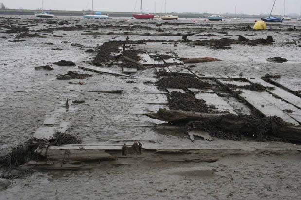
Feature XI – Oyster Pit
Further details of this feature have been included to provide an example of the more
detailed information recorded about each oyster pit. Pit XI is quite well exposed and
measures 11.5m by 14.3m (Figure 7). It is mostly constructed with horizontal
planking supported by posts, although in its north east corner there is some evidence
of a possible repair using vertical planking inside the pit. This north east corner of the
pit is supported by a ¼ cut rounded timber. Copper nails used for fastening the
planking to the posts are visible on the south side of the pit. There is a gap towards
the eastern edge of the south side of the pit that appears to correspond with a gap on
the north side of Pit XV. A small waterway or ‘gutter’ between the two pits is visible
(Figure 8). On the ‘Oyster Bed and Layings’ map based on the 1898/1915 OS maps,
this pit is marked as pit number 3 owned by J. D Foster.

                          Figure 7: Plan of Feature XI, oyster pit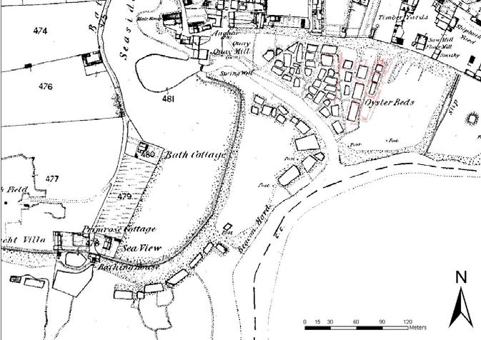
Figure 8: The south side of Pit XI looking north with a shallow but discernable “waterway”
             running through a gap in the side towards the north side of Pit XV.

Feature XVII – The Ark
The upstanding remains of The Ark were removed in 1978. The surviving remains
represent the base of a floating jetty designed to hold oysters dredged up by the
oyster fleet. The surviving timber remains (Figure 9) look well preserved, but the
overall structure is badly broken and much of it is covered by debris and mud, which
obscures the remains.

                     Figure 9: The partially exposed remains of the Ark.

Interpretation of the Surviving Foreshore Remains
The timber structures recorded represent the bases of the large timber lined pits
used for storing oysters ready for the market. Documents show that oysters were
collected from the pits at any time of the day and at any state of the tide as they were
never covered by more than 4ft (1.2m) of water. Special rakes were used to gather
the oysters before they were transferred to barrels for delivery.

It is thought the pits were constructed by excavating shallow pits into the foreshore
and using the material removed to form banks and paths around them. The pits were
then lined with timber to stop them filling with mud and shingle. Some of the pits may
have been linked via timber lined conduits or gutters, there are likely to have been used to control water levels, or to rake oysters through. Although the remains of The Ark could not be safely surveyed there are still substantial remains surviving. This was designed by JD Foster to be used as a landing stage for oyster smacks with the bottom half being storage tanks for scallops. Boats would drop their catches on The Ark from where they would be sorted and either taken to pits to mature or to Emsworth for storage (Rudkin 2004, 19). Archaeological Significance of the Site The archaeological remains of the oyster beds at Emsworth are significant. They represent relatively well preserved remains of a once thriving, highly developed, large industry that was important to the local economy and wider Solent region. As the current archaeological work was limited to survey it is unclear how extensive and well preserved the remains are below the foreshore. However, the waterlogged and anaerobic conditions provided by the mud should mean buried remains are well preserved. There is also the potential that buried elements of pits known to have been removed in the 1960s (J. Tweddell, pers. comm.) may survive below the current foreshore. Although a reduction in foreshore levels over the past few decades has not revealed any traces of these structures. Although the first record of the use of oyster pits dates to the 17th Century, it is unclear when the pits at Emsworth were first constructed. There is documentary evidence for an ‘oyster fishery’ in or around Emsworth from the Medieval period, however it is unclear whether this would have used oyster pits or would have relied on dredging natural beds. The oyster beds are clearly well established by the time of the 1866 OS map. The documentation relating to the later 19th and 20th century Emsworth oyster industry, particularly JD Fosters business, provide important historical context for the archaeological remains. In terms of comparable archaeological sites there are a number of others within Chichester Harbour at Birdham, Prinsted and Bosham (Maritime Archaeology 2007, 70). Within the Solent region the Hayling Island oyster fishery is close to Emsworth and has historical links. Further oyster ponds and beds are recorded at Cosham and Porchester in the Eastern harbours, Croften near the Meon Estuary, Eling and Dibden on Southampton Water and Stanswood in the West Solent (Tubbs 1999). This demonstrates how the Emsworth pits have local and regional connections. More widely there are sites in Essex (Fulford et al 1997, 87-88) and Kent (Wessex Archaeology, 2005) where coastal surveys have recorded a number of sites related to the oyster industry, which is also well documented historically. However, there have been very few detailed archaeological investigations of these remains. The existence of other large scale oyster farming enterprises is well documented in southern England, and there were large oyster fisheries at Whitstable in Kent, as well as Brightlingsea in Essex that have survived to the present day. Whitstable and Brightlingsea were notable as the chief oyster grounds of British fisheries in the early 20th century just after the Emsworth industry collapsed (Jones 1926, 82). These industries survive in a substantially reduced form and the industry no longer makes use of pits of the kind used at Emsworth.
Conclusions & Recommendations
The lack of any systematic investigation into the archaeology of coastal fishing and
oyster fishing have been identified in the past as serious omissions and a weakness
in the archaeological record (Fulford et al 1997; 103, 124). The work at Emsworth
provides a useful baseline of data to help address this gap in knowledge and further
archaeological investigations of the site have the potential to inform regional studies
of the Post medieval and possibly even Medieval fisheries of the region.

There is still more archaeological work that could be done to improve understanding
and to make sure remains are recorded as erosion exposes them. To find out more
about evidence surviving below the foreshore would require an excavation, this may
reveal more about the construction of the beds and provide opportunities for taking
samples for dating the structures.

There are also other remains of oyster beds, pits and ponds in Chichester Harbour at
Bosham, Birdham and Prinsted, survey of these would provide a good comparison
with the Emsworth site.

Acknowledgements
The project was commissioned by Emsworth Maritime and Historical Trust (EMHT) and
funded by Chichester Harbour Conservancy (CHC) Sustainable Development Fund.
Chichester District Archaeological Society (CDAS) members were actively involved in the
survey which was over seen by the Hampshire and Wight Trust for Maritime Archaeology
(HWTMA). The substantial documentary archive held by the Emsworth Museum was used to
provide the historical context for the archaeological remains.
Site survey was undertaken by CDAS and EMHT volunteers with advice from HWTMA staff.

References
Eyton. T. C. 1858, A History of the Oyster and the Oyster Fisheries
Fulford, M., Champion, T., Long, A. (eds), 1997. England’s Coastal Heritage: A Survey for
English Heritage and the RCHME. RCHME/EH Archaeological Report 15.
Jones, R., 1926, ‘The British Fisheries’, Economic Geography. Vol. 2 No. 1
Maritime Archaeology Ltd., 2007, Chichester Harbour Survey of Foreshore Structures.
Unpublished report Ref MA Ltd No 1752 Final Report Version 3
Potter, T. W., and Johns, C. 1992, Roman Britain
Rudkin, D. J., 2004, The Emsworth Oyster Fleet; Industry and Shipping.
Tubbs, C., 1999, Ecology, conservation and history of the Solent
Wessex Archaeology, 2005, North Kent Coast Rapid Coastal Zone Assessment Survey.
Phase II Field Assessment Year One Report. Unpublished report ref. 56750.02
Whitfield, R., 2005, Emsworth: A History
You can also read