Upper Shannon (Lough Ree) Catchment Assessment 2010-2015 - (HA 26E) - Catchment Science & Management Unit Environmental Protection Agency ...
←
→
Page content transcription
If your browser does not render page correctly, please read the page content below
Upper Shannon (Lough Ree)
  Catchment Assessment
        2010-2015
         (HA 26E)

  Catchment Science & Management Unit

    Environmental Protection Agency
            December 2018
             Version no. 3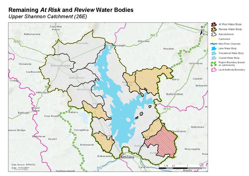
Preface
This document provides a summary of the characterisation outcomes for the water resources of the
Upper Shannon (Lough Ree) Catchment, which have been compiled and assessed by the EPA, with the
assistance of local authorities and RPS consultants. The information presented includes status and risk
categories of all water bodies, details on protected areas, significant issues, significant pressures, load
reduction assessments, recommendations on future investigative assessments, areas for actions and
environmental objectives. The characterisation assessments are based on information available to the
end of 2015. Additional, more detailed characterisation information is available to public bodies on the
EPA WFD Application via the EDEN portal, and more widely on the catchments.ie website. The purpose
of this document is to provide an overview of the situation in the catchment and help inform further
action and analysis of appropriate measures and management strategies.
This document is supported by, and can be read in conjunction with, a series of other documents which
provide explanations of the elements it contains:

    1. An explanatory document setting out the full characterisation process, including water body,
       subcatchment and catchment characterisation.
    2. The Final River Basin Management Plan, which can be accessed on: www.catchments.ie.
    3. A published paper on Source Load Apportionment Modelling, which can be accessed at:
       http://www.jstor.org/stable/10.3318/bioe.2016.22
    4. A published paper on the role of pathways in transferring nutrients to streams and the relevance
       to water quality management strategies, which can be accessed at:
       http://www.jstor.org/stable/pdf/10.3318/bioe.2016.19.pdf
    5. An     article   on    Investigative   Assessments       which     can     be    accessed     at:
       https://www.catchments.ie/download/catchments-newsletter-sharing-science-stories-june-
       2016/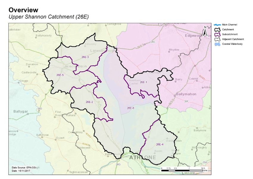
Table of contents
1     Introduction .......................................................................................................................... 1
2     Water body status and risk of not meeting environmental objectives ............................... 2
    2.1     Surface water ecological status ..................................................................................... 2
      2.1.1        Rivers and lakes ..................................................................................................................2
    2.2     Groundwater status....................................................................................................... 5
    2.3     Risk of not meeting surface water environmental objectives ...................................... 5
      2.3.1        Rivers and lakes ..................................................................................................................5
    2.4     Risk of not meeting groundwater environmental objectives ....................................... 6
    2.5     Protected areas ............................................................................................................. 6
      2.5.1        Drinking water abstractions ............................................................................................... 6
      2.5.2        Bathing Waters...................................................................................................................6
      2.5.3        Shellfish Areas ....................................................................................................................7
      2.5.4        Nutrient Sensitive Areas ....................................................................................................7
      2.5.5        Natura 2000 Sites ...............................................................................................................7
    2.6     Heavily modified water bodies ...................................................................................... 7
3     Significant issues in At Risk water bodies ............................................................................ 7
4     Significant pressures............................................................................................................. 7
    4.1     Water bodies ................................................................................................................. 7
      4.1.1        Rivers and lakes ..................................................................................................................7
      4.1.2        Groundwater ......................................................................................................................8
    4.2     Pressure type ................................................................................................................. 8
      4.2.1        Agriculture ..........................................................................................................................8
      4.2.2        Diffuse urban ......................................................................................................................8
      4.2.3        Other significant pressures ................................................................................................ 8
      4.2.4        Urban waste water treatment plants ................................................................................ 9
      4.2.5        Hydromorphology ..............................................................................................................9
      4.2.6        Extractive industry ...........................................................................................................10

5     Load reduction assessment ................................................................................................ 13
    5.1     River water body load reductions ............................................................................... 13
    5.2     TraC load reductions.................................................................................................... 13
6     Further Characterisation and Local Catchment Assessments ........................................... 14
7     Catchment summary .......................................................................................................... 14
8     Areas for Action .................................................................................................................. 14
    8.1     Process of Selection ..................................................................................................... 15
    8.2     Outcomes of process ................................................................................................... 15
9     Environmental Objectives .................................................................................................. 16
9.1      Surface Water .............................................................................................................. 16
   9.2      Groundwater ............................................................................................................... 17
10 Acknowledgements ............................................................................................................ 17
1   Introduction
This catchment covers an area of 581km² and is characterised by a relatively flat landscape underlain by
impure limestones to the east and purer and karstified limestones under and to the west of Lough Ree.
There are extensive sand and gravel deposits to the east and northeast of Athlone that form a
productive groundwater aquifer. The western part of the catchment is drained by the Hind River, which
flows south through Roscommon Town before turning east and making its way to Lough Ree. There are
numerous karst depressions and springs in the western part of the catchment. The River Inny flows into
Lough Ree from the east about halfway between the northern and southern ends of the lake. The south-
eastern corner of the catchment is drained by the Breensford River which flows west from Mount
Temple and into Lough Ree via Killinure Lough. The Shannon outflows from the southern end of Lough
Ree making its way towards Athlone.
The Upper Shannon (Lough Ree) catchment comprises six subcatchments (Table 1, Figure1) with 18
river water bodies, nine lakes and six groundwater bodies. There are no transitional or coastal water
bodies in the catchment.
Table 1. List of subcatchments in the Upper Shannon (Lough Ree) catchment
 Subcatchment ID                                   Subcatchment Name
 26E_1                                             Bilberry_SC_010
 26E_2                                             Knockcroghery_SC_010
 26E_3                                             Clooneigh_SC_010
 26E_4                                             Breensford_SC_010
 26E_5                                             Hind_SC_010
 26E_6                                             Shannon[Upper]_SC_090

Figure 1. Subcatchments in the Upper Shannon (Lough Ree) catchment

                                                   1
2 Water body status and risk of not meeting environmental objectives
2.1 Surface water ecological status
2.1.1 Rivers and lakes
♦ There were four (15%) river and lake water bodies at Good or High status, and nine (33%) at less
than Good status in 2015 (Table 2, Figure 2). Fourteen (52%) rivers and lakes are unassigned.
♦ One lake water body has a high ecological status objective (Coosan). In 2015 this achieved High
status (Figure 3, Appendix 1).
♦ The numbers of water bodies at each status class in 2007-09 and 2010-15 are shown in Figures 4
(rivers) and 5 (lakes).
♦ Four water bodies have improved and three have deteriorated since 2007-09 (Figure 6).
♦ The variation in nutrient concentrations and loads in the Upper Shannon main channel (Hind) is
illustrated in Appendix 2.
Table 2. Summary of water body status and risk results for rivers and lakes
Number 2010-15 Status Risk Categories
of water Not at At
bodies High Good Mod Poor Bad Unassigned Review
Risk Risk
Rivers 18 0 1 4 4 0 9 3 7 8
Lakes 9 1 2 1 0 0 5 4 4 1
River status over the WFD cycles
No. of Water Bodies
10
8
6
Unassigned
Unassigned
4
Moderate
Moderate
Poor
Poor
2
Good
Good
Bad
0
07-09 10-15
WFD Cycles and Status
Figure 4. Number of rivers at each status class in 2007-09 and 2010-15
2Figure 2. Surface water ecological status
Figure 3. High ecological status objective water bodies and sites
3Lake status over the WFD cycles
6
No. of Water Bodies
4
Unassigned
Unassigned
2 Moderate
Moderate
Good
Good
High
High
0
07-09 10-15
Monitoring Cycles and Status
Figure 5. Number of lakes at each status class in 2007-09 and 2010-15
Figure 6. Surface water body status changes from 2007-09 to 2010-15
42.2 Groundwater status
♦ All six groundwater bodies were at Good status in 2015 (Table 3).
Table 3. Summary of water body status and risk for ground waters
2010-15 Status Risk Categories
Number of
water bodies Good Poor Not at Risk Review At Risk
Groundwater 6 6 0 2 4 0
2.3 Risk of not meeting surface water environmental objectives
2.3.1 Rivers and lakes
♦ There are three river and four lake water bodies that are Not at Risk (Figure 7, Table 2) which require
no additional investigative assessment or measures to be applied, other than those measures that
are already in place.
♦ There are seven river and four lake water bodies in Review. This includes 10 water bodies where
more information is required and one water body where measures have recently been
implemented and improvements have not yet been realised.
♦ Eight river water bodies and one lake water body in the catchment are At Risk of not meeting their
water quality objectives. Measures will be needed in these water bodies to improve the water
quality outcomes. Summary information for the At Risk water bodies is given in Appendix 3.
Figure 7. Surface water body risk
52.4 Risk of not meeting groundwater environmental objectives
♦ Two groundwater bodies are Not at Risk (Figure 8, Table 3) and require no additional investigative
assessment or measures to be applied, other than those measures that are already in place.
♦ Four groundwater bodies are in Review (Figure 8). Funshinagh and Inny are in Review because they
are hydrologically linked to surface waters that are not meeting water quality objectives where it is
considered likely that groundwater is a contributing source of phosphorus. GWDTE-Lough Ree Fen
9 (SAC000440) is impacted by historic drainage while Athlone Gravels has elevated nitrate
concentrations.
Figure 8. Groundwater body risk
2.5 Protected areas
2.5.1 Drinking water abstractions
♦ There are 23 abstractions in the Upper Shannon (Lough Ree) catchment comprising 20 public
supplies and three private supplies (Clonrelick Infiltration G, Carrowcrim/Holywell and
Derrane/Coolteigue) (Appendix 4).
♦ All 23 of the abstractions are from groundwater bodies. Two from the Inny GWB and 21 from the
Funshinagh GWB. The list of the public supplies and the associated water bodies is provided in
Appendix 4.
♦ All sources were compliant with the standard for nitrate in 2015.
♦ All sources were compliant with the standards for pesticides in 2015.
2.5.2 Bathing Waters
♦ There are no designated bathing waters in the catchment.
62.5.3 Shellfish Areas
♦ There are no designated shellfish areas in the catchment.
2.5.4 Nutrient Sensitive Areas
♦ There are no designated nutrient sensitive areas in the catchment.
2.5.5 Natura 2000 Sites
♦ There are five Special Areas of Conservation (SACs) in the catchment (Appendix 5), not all of which
have water quality and/or quantity conservation objectives for their qualifying interests.
♦ One lake water body (Ree) has been prioritised for action as the water conservation objectives for
their habitats and/or species are not being supported by ecological status (Appendix 5).
♦ There is one Special Protected Area (SPA) in the catchment:
o Lough Ree SPA
As there are no specific water quality and quantity supporting conditions identified in the site-
specific conservation objectives for this SPA, the intersecting water bodies are not assigned priority
action for WFD protected area purposes in the second cycle.
2.6 Heavily modified water bodies
♦ There are no heavily modified water bodies (HMWBs) in the catchment.
♦ There is one artificial water body (AWB) in the catchment - the Royal Canal (West of Lough Owel
feeder). It was classified as having Good Ecological Potential (GEP) in 2010-2015.
3 Significant issues in At Risk water bodies
♦ Excess nutrients, primarily phosphate, leading to eutrophication is the dominant issue in the rivers
and lakes.
♦ Poor habitat quality caused by morphological and hydrological issues is also a concern in a limited
number of water bodies.
♦ Groundwater bodies act as a pathway to surface waters and may be contributing some of the
phosphate in places. A review of the pathway links is on-going. Nitrate concentrations, while
elevated in places, are not sufficiently high to cause a concern for drinking water purposes.
4 Significant pressures
4.1 Water bodies
♦ Where water bodies have been classed as At Risk, by water quality or survey data, significant
pressures have been identified.
4.1.1 Rivers and lakes
♦ The significant pressure affecting the greatest number of water bodies is urban waste water,
followed by agriculture, diffuse urban, other pressures (invasive species and waste),
hydromorphological pressures and peat drainage and extraction.
♦ Figure 9 shows a breakdown of the number of At Risk water bodies in each significant pressure
category. Significant pressures have been identified through the initial characterisation process in
7nine water bodies, three of which have multiple pressures. The significant pressures will be refined
as further characterisation is carried out.
4.1.2 Groundwater
♦ There are no At Risk groundwater bodies within the catchment.
Significant pressures in At Risk water bodies
4
No. of water bodies
3
2
Lakes
1 Rivers
0
Figure 9. Significant pressures impacting on At Risk water bodies
4.2 Pressure type
4.2.1 Agriculture
♦ Agriculture is a significant pressure in four river water bodies, Clooneigh_010, Clooneigh_020,
Breensford_010 and Rocksavage_010 (Figure 10). The issues related to farming in this catchment
are diffuse phosphorus loss to surface waters from, for example, direct discharges; or runoff from
yards, roadways or other compacted surfaces, or runoff from poorly draining soils. Sediment can
also be a problem from land drainage works, bank erosion from animal access or stream crossings.
The pollution impact potential map showing areas of relative risk for phosphate loss from
agriculture to surface water is given in Appendix 6.
4.2.2 Diffuse urban
♦ Diffuse urban pressures, caused by misconnections, leaking sewers and runoff from paved and
unpaved areas, have been identified as a significant pressure in four river water bodies (Hind_010,
Hind_020, Hind_030 and Jiggy (Hind)_010) from Roscommon town (Figure 11).
4.2.3 Other significant pressures
♦ Invasive species
Zebra mussels and Asian Clams – have been identified as a potentially significant pressure in one
lake water body, Lough Ree (Figure 12). The Asian Clams are likely present due to flow of warm
water from the power plant.
8♦ Waste
One river has been identified as impacted by waste facilities (Figure 13). The Jiggy (Hind)_010 is At
Risk due to several pressures including leachate from Roscommon Landfill Facility (W0073).
4.2.4 Urban waste water treatment plants
♦ Urban Waste Water Treatment Plants (WWTPs) and agglomeration networks have been identified
as a significant pressure in two At Risk water bodies, Lough Ree and Jiggy (Hind)_010; details are
given in Table 4, Figure 14. Upgrade works on the Rocommon agglomeration network, which is
impacting Jiggy (Hind)_010, are scheduled to be completed by 2020.
Table 4. Waste Water Treatment Plants and agglomerations identified as significant pressures in At
Risk water bodies and expected completion dates for associated upgrade works, where applicable.
Facility Type 2010-15 Ecological Expected Completion
Facility name Water Body Date
(p.e) Status
Ballyleague 1,001 to 2,000
Lough Ree Moderate
D0229 p.e. NA 1
Hodson Bay
500 to 1,000 p.e. Lough Ree Moderate
D0377 NA 1
Roscommon 2,001 to 10,000
Jiggy (Hind)_010 2 Poor
D0116 p.e. 2020
Figure 10. Water bodies that are At Risk and are impacted by agricultural activities
4.2.5 Hydromorphology
♦ Hydromorphology is a significant pressure in one water body. The Jiggy (Hind)_010 within the Hind
(26E_5) subcatchment is subject to extensive modification due to the presence of a drainage
1 Currently not specified in improvement plans.
2 The agglomeration network rather than the WWTP, has been identified as a significant pressure impacting Jiggy (Hind)_010.
9scheme and flood alleviation works. This water body that is At Risk and impacted by
hydromorphological pressures as shown in Figure 15 and listed in Appendix 3.
4.2.6 Extractive industry
♦ Peat
Peat drainage and extraction has been identified as a significant pressure in one water body,
Breensford_010, with peat cutting resulting in elevated sediment (Figure 16). This has resulted in
increased sediment loads, which alters habitats, morphology and hydrology.
Figure 11. Water bodies that are At Risk and are impacted by diffuse urban pressures
10Figure 12. Water bodies that are At Risk and are impacted by invasive species
Figure 13. Water bodies that are At Risk and are impacted by waste
11Figure 14. Water bodies that are At Risk and are impacted by urban waste water
Figure 15. Water bodies that are At Risk and are impacted by hydromorphological pressures
12Figure 16. Water bodies that are At Risk and are impacted by extractive industries
5 Load reduction assessment
5.1 River water body load reductions
♦ Phosphate is the main parameter influencing water quality in rivers in the catchment.
♦ Using the available monitoring data, it has been calculated that in order to achieve mean phosphate
concentrations below the EQS of 0.035 mg/l (mean), in the monitored water bodies across the
catchment, additional load reductions are required in one river water body, the Hind_010 (Table 5).
♦ The information given below should be taken as a guide which is aimed at i) enabling resources to
be targeted to specific areas requiring improvement and ii) estimating the amounts of reductions
needed so that appropriate measures can be considered. While some of the load reductions
required may be achieved from measures that are already in place (but water quality improvements
are not yet evident), it is also possible that additional load reductions will be required because of
increased pressures in some places. Investigative assessments will also likely provide evidence for
additional load reduction requirements, especially in unmonitored water bodies.
Table 5. Relative load reductions required in monitored water bodies that are At Risk.
Water Body P Load Reduction Required
Hind_010 Med
5.2 TraC load reductions
♦ There are no TraC water bodies in the Upper Shannon (Lough Ree) catchment.
136 Further Characterisation and Local Catchment Assessments
♦ Further characterisation through Local Catchment Assessments is needed in nine of the At Risk
water bodies to refine the understanding of the significant pressures at the site/field scale so that
specific and targeted measures can be identified.
♦ Further characterisation through Local Catchment Assessments is needed in 11 Review water bodies
to refine the understanding of the significant pressures at the site/field scale so that specific and
targeted measures can be identified.
♦ Brief definitions on the 10 IA assessment scenarios are given in Appendix 7 and the number of IAs
required for each scenario are given in Table 6.
Table 6. Local catchment assessment allocation for At Risk and Review river and lake water bodies
Risk IA 1 IA 2 IA 3 IA 4 IA 5 IA 6 IA 7 IA 8 IA 9 IA 10 Total
At Risk 7 0 1 0 0 4 3 0 1 0 16
Review 2 0 9 0 0 1 0 0 1 0 13
Note water bodies may have multiple categories of Local Catchment Assessments
7 Catchment summary
♦ Of the 18 river water bodies, eight are At Risk of not meeting their WFD objectives.
♦ One out of nine lake water bodies is At Risk of not meeting its WFD objectives.
♦ Excess nutrient loss, mainly phosphate, leading to eutrophication is a major issue for rivers and lakes
in the catchment. The significant pressures relating to excess nutrients are primarily urban waste
water, agricultural and diffuse urban pressures.
♦ Hydromorphological (or physical) conditions (including the input of high levels of fine sediment) and
poor habitat quality are an issue for a limited number of surface water bodies.
♦ There are no groundwater bodies At Risk. Groundwater bodies act as a pathway to surface waters
and may be contributing some of the phosphate in places. A review of the pathway links is on-going.
Nitrate concentrations, while elevated in places, are not sufficiently high to cause a concern for
drinking water purposes.
8 Areas for Action
The characterisation outcomes described above have highlighted that there is significant work to do in
the catchment to protect and restore water quality, and meet the objectives of the WFD. During the
development of the draft river basin management plan it became apparent that there would be a need
to prioritise areas for collective action so that the best return on investment could be achieved. 190
14Areas for action have been selected nationally in a process as described below. There are 2 areas for
action in the Upper Shannon (Lough Ree) catchment.
8.1 Process of Selection
Following the publication of the draft river basin management plan in early 2017, the EPA and the Local
Authority Waters and Communities Office (LAWCO) jointly led a collaborative regional workshop
process to determine where, from a technical and scientific perspective, actions should be prioritised in
the second cycle. The prioritisation process was based on the priorities in the draft river basin
management plan, the evidence from the characterisation process, and the expertise, data and
knowledge of public body staff with responsibilities for water and the different pressure types. The
recommended areas for action selected during the workshops were then agreed by the Water and
Environmental Regional Committees.
The recommended areas for action are an initial list of areas where action will be carried out in the
second cycle. All water bodies that are At Risk still however, need to be addressed. As issues are
resolved, areas for action will be removed from the list and new areas will be added. If additional
monitoring shows that new issues have arisen, new areas may become a priority and may need to be
added to the work programme.
The initial list of areas for action is not therefore considered as a closed or finite list; it simply represents
the initial areas where work will be carried out during the second WFD planning cycle from 2018 to
2021.
8.2 Outcomes of process
The outcomes for the Upper Shannon (Lough Ree) catchment are summarised below.
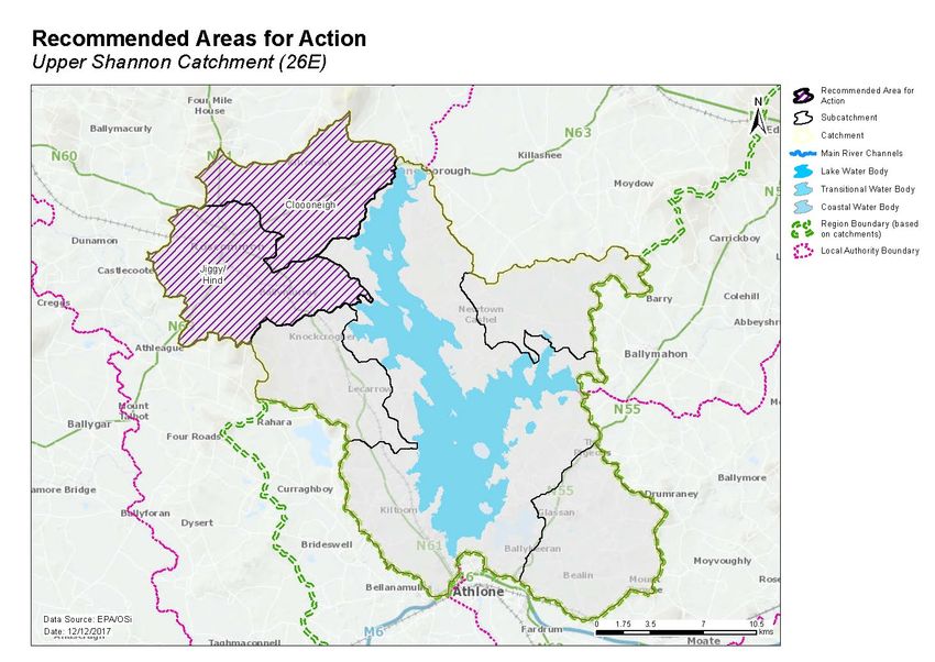
♦ Two recommended areas for actions (Table 7, Figure 17) were selected.
♦ These are the Jiggy/Hind and Clooneigh.
♦ These include seven At Risk and one Review river water bodies.
♦ One groundwater body, which is in Review due to groundwater contribution of nutrients to
surface water bodies, intersects with the two recommended areas for action, see Table 8.
Actions taken to improve surface water will need to take account of the groundwater
contribution to surface water.
A remaining 12 At Risk and Review surface water bodies were not included in the recommended areas
for action for the second cycle. The distribution of these is presented in Figure 18. These include:
♦ twelve surface water bodies – two At Risk and 12 Review.
Table 7. Recommended Areas for Action in the Upper Shannon (Lough Ree) Catchment
Number
Recommended
of water SCs Local authority Reason for Selection
area for action
bodies
15• Building work completed by Roscommon County
Council to address diffuse urban pollution.
• Potential 'quick win' in the upper reaches of the
Jiggy/Hind 5 26E_5 Roscommon
subcatchment.
• One deteriorated water body.
• Headwaters flowing into Lough Rinn.
• Manageable area to focus measures.
• Two potential 'quick wins'.
Clooneigh 3 26E_3 Roscommon
• Two deteriorated water bodies.
• Headwaters flowing into Lough Rinn.
Table 8. Groundwater bodies intersecting with surface water bodies in areas for action
Groundwater body Intersecting surface water body Recommended
Code Name Risk Code Name Area for Action
IE_SH_26C060030 CLOONEIGH_010
IE_SH_26C060200 CLOONEIGH_020 Cloooneigh
IE_SH_26K670950 KEELCURRAGH_010
IE_SH_26H010300 HIND_010
IE_SH_G_091 Funshinagh Review
IE_SH_26H010400 HIND_020
IE_SH_26H010500 HIND_030 Jiggy/Hind
IE_SH_26J010090 JIGGY (HIND)_010
IE_SH_26R070250 ROCKSAVAGE_010
9 Environmental Objectives
9.1 Surface Water
♦ Assuming resources are available and actions are taken in the recommended areas for action, of
the seven At Risk river water bodies, it is predicted that three (43%) will improve by 2021 and four
(57%) will achieve their objective by 2027. For the one Review river water body, the absence of
information on this water body means that there is no scientific basis to quantify an environmental
objective date, and therefore a 2027 date is set for this water body, see Table 9.
Table 9. Environmental objective dates for water bodies in the Areas for Action
Risk Category No. of Water No. of WBs for 2021 No. of WBs for 2027
Bodies Improvement Status Improvement
At Risk 7 3 4
Review 1 0 1
Not at Risk 0 0 0
Total 8 3 5
♦ Seven surface water bodies have met their 2015 environmental objective.
♦ As action is not yet planned to be taken in the remaining two At Risk surface water bodies, a 2027
date is applied to them both.
16♦ For the ten Review surface water bodies, the absence of information on these water bodies means
that there is no scientific basis to quantify an environmental objective date and therefore a 2027
date is applied, see Table 10.
Table 10. Environmental objectives dates in the At Risk and Review surface water bodies not included
in Areas for Action
Risk No. of Water No. of WBs for 2021 No. of WBs for 2027
Category Bodies Improvement Status Improvement
Rivers
At Risk 1 0 1
Review 6 0 6
Lakes
At Risk 1 0 1
Review 4 0 4
Total 12 0 12
9.2 Groundwater
♦ All six groundwater bodies in the catchment are Good status and, therefore, have met their
environmental objectives.
10 Acknowledgements
This Upper Shannon (Lough Ree) Catchment Assessment (Version 3) has been produced by the
Catchment Science & Management Unit, EPA, with the assistance of the following:
• Roscommon County Council
• Longford County Council.
• Westmeath County Council.
• Inland Fisheries Ireland.
• Local Authorities Waters & Communities Office.
• Irish Water.
• RPS Group.
• Ecological Monitoring & Assessment Unit, EPA.
• Hydrometric & Groundwater Section, EPA.
• Informatics Section, EPA.
• Laboratories, EPA.
• Office of Environmental Enforcement, EPA.
• DAFM Agriculture.
• DAFM Forest Service.
• Coillte.
• Teagasc.
• Geological Survey Ireland.
• National Parks and Wildlife Service.
• Marine Institute.
17Figure 17. Location of Recommended Areas for Action in the Upper Shannon (Lough Ree) Catchment
18Figure 18. Location of At Risk and Review water bodies located outside Recommended Areas for Action in the Upper Shannon (Lough Ree) Catchment
19Appendix 1 High ecological status objective water bodies
Water body/Site Type Codes 2015 Status
Coosan Lake IE_SH_26_750c High
20Appendix 2 Catchment scale nutrient concentrations and in-stream loads
The results of the instream water quality assessment for the Shannon (Upper and Lower) main channel
are illustrated in Chart 1. The assessment is based on the mean concentrations between 2013 and 2015
at each site where monitoring data is available. Only 12 of the 17 main channel water bodies have water
quality data associated with them.
The results show that average nutrients concentrations in the Shannon main channel are below their
corresponding threshold values. Concentrations of orthophosphate range from 0.008 to 0.017mg/l,
with the highest concentration observed in the headwater SHANNON (UPPER)_010. Small spikes of
orthophosphates are observed in the SHANNON (UPPER)_100, which receives water from the FEORISH
(TARMONBARRY)_020 of poor ecological status, and the SHANNON (LOWER)_060 which is the receives
the primary discharge from the Castleroy Waste water Treatment Plant (WWTP).
Ammonia concentrations show no significant trend along the main channel and range from 0.018 to
0.037mg/l. The small concentration spikes of ammonia are observed in SHANNON (UPPER)_070 and
SHANNON (LOWER)_010. The SHANNON (UPPER)_070 is the receiving water body for several small
WWTPs including Dromod, Drumsna, Jamestown and Roosky & Environs. The SHANNON (LOWER)_010
is the receiving water body for the Banagher WWTP.
Total Oxidised Nitrogen (TON) concentrations are low at the head waters but increase from 0.018mg/l
in the SHANNON (UPPER)_090 to 0.92mg/l in the SHANNON (LOWER)_060. TON remains well below the
2.6mg/l threshold value throughout the channel.
Chart 1: Upper and Lower Shannon Main Channel
Nutrients
0.045 3.5
Ortho-P & Total Ammonia (mg/l)
Total Oxidised itrogen (mg/l)
0.040 3.0
0.035
2.5
0.030
0.025 2.0
0.020 1.5
0.015
1.0
0.010
0.005 0.5
0.000 0.0
Ortho-Phosphate (mg/l as P) Tot Ammonia (mg/l as N)
Total Oxidised Nitrogen (mg/l as N)
21Appendix 3 Summary information on At Risk and Review surface water bodies
High
Ecological
Status
Water Ecological Ecological Objective Date to Meet
Subcatchment Water body body Status Status Water Body Environmental Recommended Area
code code Water body name type Risk 07-09 10-15 Y/N Significant Pressures Objective for Action Name
26E_1 IE_SH_26_638 Derrymacar Lake Review Unassigned Unassigned N 2027
26E_1 IE_SH_26_750a Ree Lake At Risk Moderate Moderate N Other,UWW 2027
26E_1 IE_SH_26D080850 Drumnee_010 River Review Unassigned Unassigned N 2027
26E_1 IE_SH_26L840850 Ledwithstown_26_010 River Review Unassigned Unassigned N 2027
26E_2 IE_SH_26C230700 Carrowphadeen_010 River Review Unassigned Unassigned N 2027
26E_3 IE_SH_26C060030 Clooneigh_010 River At Risk Good Moderate N Ag 2021 Cloooneigh
26E_3 IE_SH_26C060200 Clooneigh_020 River At Risk Good Moderate N Ag 2021 Cloooneigh
26E_3 IE_SH_26K670950 Keelcurragh_010 River Review Unassigned Unassigned N 2027 Cloooneigh
26E_4 IE_SH_26B100100 Breensford_010 River At Risk Poor Moderate N Ag,Peat 2027
26E_4 IE_SH_26G060300 Glassan Stream_010 River Review Unassigned Unassigned N 2027
26E_5 IE_SH_26H010300 Hind_010 River At Risk Poor Poor N DU 2027 Jiggy/Hind
26E_5 IE_SH_26H010400 Hind_020 River At Risk Poor Poor N DU 2027 Jiggy/Hind
26E_5 IE_SH_26H010500 Hind_030 River At Risk Moderate Poor N DU 2027 Jiggy/Hind
26E_5 IE_SH_26J010090 Jiggy (Hind)_010 River At Risk Bad Poor N DU,Hymo,Other,UWW 2027 Jiggy/Hind
26E_5 IE_SH_26R070250 Rocksavage_010 River At Risk Poor Moderate N Ag 2021 Jiggy/Hind
26E_6 IE_SH_26_498 Ross WH Lake Review Unassigned Unassigned N 2027
26E_6 IE_SH_26_511 Creggan Lake Review Unassigned Unassigned N 2027
26E_6 IE_SH_26_623 Doonis Lake Review Unassigned Unassigned N 2027
26E_6 IE_SH_26B210730 Ballybay_26_010 River Review Unassigned Unassigned N 2027
26E_6 IE_SH_26S021660 Shannon (Upper)_110 River Review Unassigned Unassigned N 2027
Ag: Agriculture M+Q: Mines and Quarries
DWW: Domestic Waste Water Peat: Peat Drainage and Extraction
Protected Area: If water body is one or
For: Forestry DU: Diffuse Urban more of the following, Drinking Water
Protected Area, Bathing Water, Shellfish
Hymo: Hydromorphology UWW: Urban Waste Water Water, Nutrient Sensitive Area or a
Natura 2000 site with qualifying interest,
Ind: Industry then it has been highlighted as a
protected area in this table.
Note: Significant Pressures for Review water bodies have not been included as they will need to be confirmed as part of an Investigative Assessment.
22Appendix 4 Drinking water supplies in the catchment
Water Body Objective
Scheme Code Scheme Name Water Body
Code met?
2000PUB1007 Glenmore Spring
Inny GWB IE_SH_G_110 Yes
3200PRI2001 Clonrelick Infiltration G
2000PUB1009 Lanesboro
2000PUB1013 Newtowncashel
2600PRI3017 Carrowcrim/Holywell
2600PRI3034 Derrane/Coolteigue
Roscommon Central WSS -Ballinagard
Borehole 1
Roscommon Central WSS -Ballinagard
Borehole 2
Roscommon Central WSS -Ballinagard
Borehole 3
Roscommon Central WSS -Ballinagard
Borehole 4
Roscommon Central WSS -Ballinagard
Borehole 5
Roscommon Central WSS -Ballinagard
2600PUB1002
Borehole 6
Roscommon Central WSS -Ballinagard Funshinagh GWB IE_SH_G_091 Yes
Borehole 7
Roscommon Central WSS -Ballinagard
Borehole 8
Roscommon Central WSS -Ballinagard
Borehole 9
Roscommon Central WSS -Ballinagard
Borehole 10
Roscommon Central WSS -Rockfield
Spring (N0.3)
Knockcroghery - Lecarrow Borehole
2600PUB1003
Knockcroghery - Toberreeoge Spring
2600PUB1006 Ballyleague
Lecarrow WSS -Borehole
2600PUB1019 Lecarrow WSS -Spring
Lecarrow WSS -Borehole
23Appendix 5 Prioritisation of water bodies with Natura 2000 site qualifying interests
Relevant
Water body Survey
SAC Name Qualifying Target status Water bodies Status (risk) Prioritise? Code
type data?
interests
Ballinturly Turlough SAC
000588 3180 Good GW level/quality Groundwater Funshinagh Good (R) No IE_SH_G_091 No
Carn Park Bog SAC 002336 none
Corbo Bog SAC 002349 none
Fortwilliam Turlough SAC
000448 3180 Good GW level/quality Groundwater Funshinagh Good (R) No IE_SH_G_091 No
Lough Ree SAC 000440 Potential 3150 Good Lake Ree Moderate (AT RISK) Yes IE_SH_26_750a Yes
7230 Good GW level Groundwater Curraghroe Good (NAR) No IE_SH_G_075 No
Groundwater Funshinagh Good (R) No IE_SH_G_091 No
Groundwater Inny Good (R) No IE_SH_G_110 No
GWDTE Lough Ree Fen
Groundwater 12 (SAC000440) Good (NAR) No IE_SH_G_165 No
GWDTE Lough Ree Fen 9
Groundwater (SAC000440) Good (R) No IE_SH_G_162 No
Groundwater Athlone Gravels Good (R) No IE_SH_G_246 No
24Appendix 6 Pollution Impact Potential (PIP) Map for Phosphate
For areas where agriculture is deemed as the significant pressure, areas of high risk to surface water
can be targeted. The map below shows relative risk of loss of phosphate to surface water. The risk of
phosphate losses is strongly correlated on whether the land is poorly draining or free draining and the
loadings applied i.e. significant loadings applied on poorly draining areas result in a high potential risk to
surface water. However, this figure does not imply that actual losses from these areas are occurring but is a
useful tool for informing where resources should be focused (i.e. by allowing high risk areas to be identified
and prioritised for further investigation). PIP maps are available online at a scale of 1:20,000 and can be
accessed by public bodies via the EDEN process.
25Appendix 7 Local catchment assessment categories
Category Assessment & Measures Evaluation Details
IA1 Further information provision (e.g. from IFI, LAs, EPA)
IA2 Point source desk-based assessment
IA3 Assessment of unassigned status water bodies, requiring field visit(s)
IA4 Regulated point sources, requiring field visit/s
IA5 Stream (catchment) walk to evaluate multiple sources in a defined (1 km) river stretch
(used as the basis for estimating resource requirements)
IA6 Stream (catchment) walk in urban areas
IA7 Stream (catchment) walk along >1 km river stretches
IA8 Stream (catchment) walk along high ecological status (HES) objective rivers
IA9 Lakes assessment, requiring field visits
IA10 Groundwater assessments, requiring field visits
26You can also read