Urban Sprawl: A Case Study of Lucknow City - International ...
←
→
Page content transcription
If your browser does not render page correctly, please read the page content below
International Journal of Humanities and Social Science Invention
ISSN (Online): 2319 – 7722, ISSN (Print): 2319 – 7714
www.ijhssi.org Volume 4 Issue 5 || May. 2015 || PP.11-20

                 Urban Sprawl: A Case Study of Lucknow City

                                        Dr. (Mrs.) Kiran Kumari
            Associate Professor, Dept. of Geography, Rajiv Gandhi University, Rono Hills, Doimukh
                                      Arunachal Pradesh -791112 (India)

ABSTRACT: Cities often experience growth either physically, by population, or by a combination of
both. Urban sprawl in recent times is a subject of popular debate between policy makers and
environmentalists in context of the status of urban people and the state of the human ecology. With the high
pace of social and economic development resulting growth of urban population, lack of infrastructure,
congested traffic, environmental degradation and shortage of housing became the major issues faced by the
urban areas. The present paper is an attempt to identify and analyze the rate of urban growth, with a focus
to explore the morphological structure and characteristic of urban sprawl in Lucknow City (capital city of
the most populous state of Uttar Pradesh, situated in the middle of Gangetic Plain and spreads on the
banks of the river Gomati, a left bank tributary of river Ganga) arising out of dynamic interaction between
different urban functions along with historical, social, economic and administrative factors based on
primary and secondary data.
KEY WORDS: Low-density sprawl, Leap frog development, Ribbon sprawl, Urban Growth, Urban Sprawl

                                            I.       INTRODUCTION
          Cities often experience growth either physically, by population, or by a combination of both. Urban
sprawl is much more complicated because it may or may not qualify as urban growth. How a city grows can
create the appearance of sprawl. Such urban growth may appear as a low density leapfrog pattern, a linear or
strip development pattern a long highways, or a tightly condensed pattern of a new development around pre-
existing built-up landscapes (Nechyba etal. 2004) without urban growth there would be no appearance of urban
sprawl.Today, Urban Sprawl is one of the contemporary issues of cities all over the world. Urban Sprawl is the
outgrowth of the urban area caused by the uncontrolled and uncoordinated urban growth. Sprawl is also
considered to be an unplanned outgrowth of urban areas along the periphery of the cities, along highways, and
along the road connecting a city. Urban sprawl has been at the centre of current debate on urban structure. In the
literature of rban planning or urban economics, there is a big debate on even the definition of urban sprawl itself.
Let alone its causes and impacts (Gordan and Richardson, 1997; Ewing, 1997; Fischel, 1999; Brueckner, 2001).
          Sprawl is the spreading out of a city and its suburbs over more and more rural land at the periphery of
an urban area. This involves the conversion of open space (rural land) into built-up, developed land over time.
‘Sprawl’ in simple terms is just spreading out of a city and its suburbs over more and more rural land at the
periphery of an urban area while in reality it is a complex phenomenon that mean different things in different
areas and conditions. Sprawl is also considered to be an unplanned outgrowth of urban areas along the periphery
of the cities, along highways, and along the road connecting city. Urban sprawl refers to the outgrowth of urban
areas caused by uncontrolled, uncoordinated and unplanned urban growth. Travisi and Camagni (2005) defined
it as ‘the uncontrolled spreading out of a given city and its suburbs over more and more semi-rural land at the
periphery of an urban area’. They further state that the sprawling process of expansion is disordered,
unplanned, leading often to inefficient and unsustainable urban expansion patterns.
Urban sprawl can be categorized into three types these are as following:
Low-density Sprawl: Low-density continuous sprawl is a phenomenon caused by outward spreading of low-
density suburban land use as currently being experienced by many of cities like America as their population
becoming bigger and bigger and there is no lack of land supply. This highly consumptive use of land for urban
purposes is supported by piecemeal extensions of basic urban infrastructure such as water, sewer, power and
roads.
Ribbon Sprawl: Ribbon sprawl is a type of sprawl characterized by concentration of development along major
transportation arteries, primarily roads. While development occurs on land adjacent to the major roads, areas
without accessibility to the roads tend to remain as green areas, waiting for conversion into urban land uses
when land values increase and infrastructure is extended from the major roads.
Leapfrog Development Sprawl: Leapfrog development sprawl is a scattered form of urbanization with
disjointed patched of urban land uses, interspersed with green areas. Leapfrog development may be caused by
obvious physical limitations such as prohibitive topography, water bodies and wetlands or by more subtle
reasons such as differences in development policies between political jurisdictions. Leapfrog development
                                           www.ijhssi.org                                                11 | Page
Urban Sprawl: A Case Study…

occurs when developers build new residences some distance from an existing urban area, bypassing vacant
parcels located closer to the city. Medium density areas with low connectivity indicated leapfrog patterns.

                                           II.      OBJECTIVES
The objective of this study is to identify and analyze the rate of urban growth, with a focus to explore the
morphological structure and characteristic of urban sprawl and to focus on how urban sprawl leads to land use
change in Lucknow city.

                                        III.      METHODOLOGY
Methodology revolves around the visual interpretation and cartographic techniques, as described below:
       a. Preparation of base map from Survey of India Topographical Map 63B/13 of the study area on
           scale 1:50,000 published in 1976.
       b. Preparation of base map from Survey of India, Modified Open Series Map 63B/13, 63B/14, 63F/1
           and 63F/2 of the study area on scale 1:50,000 published in 2011.
       c. Overlaying of Modified Open Series map on Topographical Map published in 1976.
       d. Mapping it by visual interpretation
       e. Comparison and change detection by mapping
       f. Comparison with predicted reports by various development authorities.
       g. Statistical Analysis of the compared data

                                  IV.      ABOUT THE STUDY AREA
        Lucknow Metropolis lies between the coordinates of 26 o 30' N to 27o 10' N latitudes and 80o30' E to
   o
81 13' E longitudes. It is the capital city of the most populous state of Uttar Pradesh in India. Lucknow is
situated in the middle of Gangetic Plain and spreads on the banks of the river Gomati, a left bank tributary of
river Ganga. It enjoys a central position in the state of Uttar Pradesh. It is bounded on the north by Sitapur, on
the south east by the Rae Bareli, on the north east by Barabanki, on the north west by Hardoi and on the south
west by Unnao district as represented in fig. 1.
        The height of Lucknow city above mean sea level is 123 metres. The total land area of Lucknow city is
310 Sq. km. Lucknow has got an extensive network of roads and railways and it has grown all around in a radius
of 25 Km. The road network is primarily of radial pattern. Nine regional roads converge into the city from all
directions linking Lucknow to Kanpur, Sultanpur, Kursi, Faizabad, Hardoi, Rae Bareily, and Mohaan. The city
is very favorably located at a junction of three National Highways other five Provincial Highways. The NH-24
links it to Delhi in the north; NH-25 links it to the west and south via Kanpur, Jhansi and Bhopal; and NH-28
links to Patna and Calcutta in the east via Gorakhpur. Kanpur and Lucknow are separated only by 80 kms.
Lucknow - Kanpur area has become an area of intense interaction reflected by changes in land use, mushroomed
development in all sectors of the economy. It is also well connected with the railway network falling in the
Northern and North Eastern railway zones. Almost all the major train routes touch this city. It has good rail
network touching all the important rail junctions in the country. Railway ministry has given some special train
to Lucknow. The famous Satabdi and Rajdhani express passes from Lucknow to various part of the country. The
city has two major railway stations one is Lucknow railway junction and other is Charbagh station. The major
railway lines are Lucknow-Kanpur-Jhansi, Lucknow-Delhi, Lucknow-Gorakhpur, Lucknow-Rae Bareily.
Lucknow is well connected with the other important towns and cities of the country by air routes. Lucknow has
direct flight to Delhi, Mumbai, Bangalore, Patna and Sarjah. The Lucknow airport located in Amausi is only 20
km far from the city and has 7453 feet long runway. The Air India, Indian Airlines and Sahara airways has
regular scheduled flights from Lucknow to other parts of country.

                                          www.ijhssi.org                                               12 | Page
Urban Sprawl: A Case Study…

                  LOCATION MAP OF STUDY AREA :

                     Fig. 1 : Showing the Location Map of Study Area: Lucknow City

            V.       GROWTH OF CITY IN DIFFERENT EVOLUTIONARY PHASES
         The Gomti River, a tributary of Ganga rive system is the chief geographical feature, meanders through
the city, dividing it into the Trans-Gomti and Cis-Gomti regions., almost presently bifurcates the city of
Lucknow into two parts: the first part forming the core of Nawabian and British evolution of the city structure
and form, while the second half is the urban sprawl of the post-independent evolution of the city structure and
form. The urban land use and architecture may be seen in the perspective of these two periods in the
understanding of the evolution and growth related to histo-genesis and morphogenesis of the Lucknow
Metropolis. The present city of Lucknow has been divided into 40 wards and a cantonment with a population of
22.67 lakh persons (2001 census) and covering an area of 337.50 km2. Currently the population of Lucknow is
more than 3 million. The majority of Lucknow's population includes people from Eastern Uttar Pradesh.
Demographic features of Lucknow (UA) is presented in Table 1.
Table 1. Demographic Features of Lucknow(UA) –1991-2001
No        Details                            1991                   2001
1         Population
            a. Male                          892308                 1199273
            b. Female                        776896                 1067660
            c. Total                         1669204                2266933
2         Sex Ratio                          871                    890
3         Area (Sq. km)                      337.50                 337.50
4         Density of population              4946                   6717
Source: Census of India, 1991 & 2001.
         Some positive trends in the sex ratio that is an increased level from 871 to 890 during the same period
covered under the study. The information regarding the population of Lucknow UA during the last century is
presented in Table 2 is depicted in Figure 2.
                                              www.ijhssi.org                                            13 | Page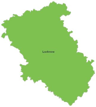
Urban Sprawl: A Case Study…

        Table 2. Population of Lucknow (UA) –1901-2001
     No                    Years                                    Population
      1                     1901                                      256239
      2                     1911                                      252114
      3                     1921                                      240566
      4                     1931                                      274659
      5                     1941                                      387177
      6                     1951                                      496177
      7                     1961                                      655673
      8                     1971                                      813982
      9                     1981                                     1007604
     10                     1991                                     1669204
     11                     2001                                     2266933
Source: Towns & Urban Agglomerations, Census of India

                                Figure 2. Population of Lucknow (UA) 1901-2001.

              2500000

              2000000

              1500000

              1000000

               500000

                     0
                         1901    1911   1921   1931   1941   1951    1961   1971    1981   1991   2001

          Lucknow, by virtue of its central location in the state, was rightly selected as the seat of administration
for Uttar Pradesh. It was the capital of Oudh kingdom during the Nawabian period due to its strategic location.
Then city of Lucknow originated around the Lakshman Tilla and Machchi Bhawan as it is asserted to be the site
of old fort built for the defence at that time, is considered as nucleus of the city. In the early period of growth
city expanded by the left bank of the river Gomti. Earlieer Rajputs, Shekhs of Bijnaur and Pathans of Ram
Nagar lived in an area between Lakshman Tilla to present Residency. Although the buildings of Lucknow was
initiated by Shekhs but it got momentum in Nawabi period. Network of roads generally become the cause of
development of any town. In case of Lucknow earlier roads were developed by the side of river Gomti in a
semi-circular way. Therefore, the city was expanded according to road network. Roads were irregular, narrow
and zigzag in shape and also unmetalled. The morphology of Lucknow is the resultant of different phases of its
evolution and growth following the internal structure, i.e., layout and form and the spatio-functional
development of urban landscape in the city.
          The city grew because of their land use pattern and functions and these different kind of functions laid
the formation of its morphological development. In Nawabian period residential colonies developed around
Chowk with peripheral areas in the surroundings (Classical Chowk Model), Baradari, Rumi Darwaja, Gol
Darwaja, Akbari Darwaja, Bazar Ghaulal, China Bazar, Aminabad, Terahi Bazar, Aminaganj, Fatehganj, etc.
were other markets along the river Gomti. The Bazars were developed with enormous economic activities
related to unique embroidery, chicken works and jewelry. The handwork on clothes were popular at that time.
Architecture was as its peak in Nawabian period. Imambara, Forts, Mohallas etc. were built by them in
Lucknow as a symbol of Nawabian architecture. At the time of Asaf-ud-Daula Lucknow started spreading along
the river Gomti. In 1816, Gasi-Uddin Haider built iron bridge (New Daliganj Bridge) down the river to facilitate
transportation between north and south of the Gomti. This bridge was mainly constructed for the purpose of the
northward development of the city. At that time, the land was generally used in residential, commercial and
recreational. In the reign of British rulers, Lucknow became administrative centre. Rapid progress started in the
planned development of Lucknow with advice of Pattrick Gedded, an urban planner. The road pattern was
                                           www.ijhssi.org                                                 14 | Page
Urban Sprawl: A Case Study…
modified (Mixed Colonial Street Model) and roads were constructed and broad. Machchi Bhawan was selected
as the residence of British military. At that time, Lucknow occupied an area of about 16 km2. After 1857,
Brigadier General Sir Robert Napier drew a plan for the city which was designed for the defence of the city. A
new era began in Lucknow after the birth of Municipal Board in 1862. The Municipal Board took planned
management of metalled and straight roads, new avenues, many gardens, parks and open spaces. In 1866,
Nishatganj bridge was constructed on river Gomti near Hazratganj bridge for development of eastern area
(Mixed Colonial Street Model). In 1867, many markets were settled at Sadatganj, Daliganj, Shahganj,
Aminabad, Rakabganj etc. Railway lines and Charbagh Railway station were constructed in1867. In 1870, the
city had spread over a total of 31.77 km2, of which 9.21 km2 of land was fully built up with 57256 houses. The
cantonment was developed in the south-eastern part of Lucknow and the military was shifted from Machchi
Bhawan and other areas to this area. Cantonment occupied an area of 27.40 km2. This era had well planned
roads, buildings, playgrounds and rifle range. It lies in the outer area near Dilkusha railway station. In new
century (1900), Municipal Board invited Patrick Geddes, a town planner of Britain to advise them. It was the
real phase of a planned layout of the city’s development for urban design and flag in the evolution of urban
landscape. Planned markets were developed as Nazirabad, Ghasiari, Madi, Chikmandi, Nazar Bagh, Raniganj,
Ganeshganj, etc. In 1928, the capital functions were shifted from Allahabad to Lucknow and the city became
administrative centre of Uttar Pradesh. The Hazratganj became the total point of all important activities,
administrative as well as commercial. All important offices related to administration and big hotels were
constructed around the Hazratganj market. The introduction of administrative and business activities allowed the
function structural development in urban process. In 1930, Lucknow was proclaimed as the state capital. It was
with the efforts of Sir Hercourt Buttler, the Governor of the state and several state offices were transferred from
Allahabad to Lucknow and were established towards the north and east of the main city. The new Civil Lines,
Mall Avenue, Council House, Residency, Clock Tower (Ghantaghar) etc. were added to the city. Aishbagh area
developed an industrial part of the city. Some small industries such as paper mill and oil mills were established
on the north western bank of river Gomti. Thus, administrative, commercial as well as industrial function
became prevalent in the urban growth of Lucknow. In the second decade of the century the University was
established across the river in Niralanagar. The decaying “Machchi Bhawan” was used for establishment of
medical college, which was the most suitable site on the Gomti bank. The form and structure of the city alone to
the urban shape with increasing number of function in quantity as well as in quality.
After independence, the Development Trust, Municipal Corporation and other statutory bodies also
ventured construction of new colonies in a planned manner. Labour colonies have also emerged as a distinct
landmark in new pattern of the city. Housing schemes for lower and middle income groups were further
emerged in the development of housing colonies. After 1971, Lucknow was extended towards Niralanagar,
Aliganj, Mahanagar, Nishatganj, New Haiderabad, Sitapur road and Faizabad road. Tal Katora road and
Aishbagh were declared site for heavy industries. Some planned and organized colonies Kanausi, Chandranagar,
Singarnagar, Ramnagar, Indralok, Krishnanagar and Vijai Nagar, were developed along the Kanpur road.
Polytechnic college and Amausi Airport were also settled in the south-eastern part along the Kanpur road. The
direction of the growth of the city was primarily envisaged only along two accesses, viz. along Kanpur and
Sitapur roads. After 1991, it has swelled along every outgoing road added to which are the Raebareli, Sitapur,
Hardoi and Faizabad roads. It really provided an access to city sprawl along the transport network. This
accessibility confirmed the movement of commodities and people not only in the intra-urban space but also in
the inter-urban space in the regional economy. An overall functional morphology of Lucknow may be analyzed
through this axial growth in all the directions by these major roads passing from the city. A number of new
colonies developed such s HAL, Ram Sagar Mishra Colony, Sarojini Nagar, Gomti Nagar, Aliganj Extension
and PAC Colony. In the south of Lucknow, there settled Telibagh and Kharika residential areas with Sanjay
Gandhi Post Graduate Institute of Medical Sciences. The intermittent filling of residential areas between major
roads allowed the development of spatial structure by evolving layout, from and shape of the city. The planned
city develop to the north of river Gomti. This area has developed colonies like Mahanagar, Aliganj, Niralanagar,
Vikas nagar, Vishnupuri, Indiranagar, Gomtinagar, Triveninagar, and so on. It happened in the process of urban
development models occupying in an Indian metropolis like Lucknow.
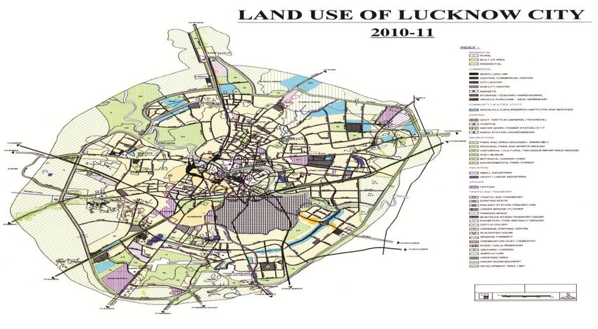
VI. EXISTING LAND USE PATTERN
It may be inferred from Table 3 and fig.3 that about one half of the existing land used is for residential
purpose. This has increased to near about two third in the proposed land use pattern of Lucknow. The area
proposed in the master plan of Lucknow had increased from the existing 9170.96 hectares to 20988.5 hectares,
showing the growth at 128.9 per cent of the area. In absolute terms it increased to 11817.54 hectares. The land
proposed for commercial purpose had increased from 2.43 per cent of the total area of the existing land use to
4.3 per cent of the total proposed area. This is a positive sign as far as the economy of Lucknow is concerned.
www.ijhssi.org 15 | PageUrban Sprawl: A Case Study…
On the contrary, industrial allocation of the land from the existing to a proposed one has dramatically reduced
from 6.5 per cent to 3.5 per cent in the proposed land use pattern. Likewise the proportion of land used for
community facilities and services has reduced from 9.83 per cent to 5.4 per cent in the proposed land use
pattern. While transportation purpose the existing as well as proposed land use system in Lucknow was more or
less same. The proposed land use pattern tries to reduce the water bodies in Lucknow. Moreover in the open
space category, the proposed land use pattern has not mentioned any figure and treated as nil, clearly narrates
the fact that all the areas are fully utilized.
Residential Land Uses
The area under existing residential use is 8945.00 Hectare (54.98 per cent) which is concentrated in
Aliganj, Indiranagar, Gomatinagar, Hussainganj, Maqboolganj, Nirala Nagar and C.B. Guptanagar wards. The
residential houses in the old parts of the city are mixed and unplanned. These are closely constructed houses
along the narrow streets and lanes being over-congested. The houses are old, dilapidated and uneventilated
unhygienic conditions. The residential areas, therefore, have a varied character from congested areas of
Kashmiri Mohalla, Asharfabad, Chowk, Aminabad, Kaisarbagh, Hussainganj, Bashiratganj etc to the spacious
and newly planned colonies of Mahanagar, Indiranagar, Gomatinagar, and so on developed in the third and
fourth stage of urban growth.
Commerical Land Use
The area under trade and commerce is covered about 360.00 Hectare which is 2.21 per cent of the total
developed land. The significant commercial areas are Chowk, Aminabad and Hazratganj. The most planned
commercial hub was created along the Hazratganj road during the British period as a fashionable and spacious
shopping complex. However, Chowk-Hazratganj, Aminabad area is considered as Central Commercial Area
(CCA) of Lucknow metropolis. Other commercial areas are Nazirabad, Quiserbagh, Maulviganj, dar,
Nishatganj, Alambagh, Daliganj, Shriram road, Faizabad road etc. The newly developed shopping complexs are
now emerged in the various planned colonies, such as Kapurthala market, Nishatganj market, Janpath market,
Lekhraj market as well as markets along Gautam Buddha Marg, Ganga Prasad Verma road, Nandan Mahal road
etc.
Industrial Land Use
Industries occupy very small area of land as it is only 6.08 per cent of the total developed urban area.
The area is mainly lying in Aishbagh, Nishatganj, Daliganj, Hindnagar and Yahiaganj. The light industrial area
of Aishbagh has the precision instrument factory, cycle parts factories, agricultural implements, general
engineering factories, electrical, hardware, chemicals, pharmaceutical, etc. Besides these Lucknow is generally
known for its small scale and handicrafts/cottage industries specially for luxury and beauty articles like-gold and
silver brocades, chicken and embroidery works and Indian perfumery as specialities. These small cottage
industries are concentrated in the muslim dominated ward such as Chowk, Aminabad, Bashiratganj, etc.
Fig. 3 :Land use Pattern of Lucknow City
www.ijhssi.org 16 | PageUrban Sprawl: A Case Study…
Land Under Public Uses
The public and semi-public uses are comprised of education, administration, recreation, health,
transport, communication, water supply, and other public uses. Land under these is 1410.00Hectare which is
8.67 per cent of the total area of the city. The most prominent institutions of higher education are Lucknow
University, Chhatrapati Sahuji Maharaj Medical Colleges, Engineering Colleges, Isabels Thornburn College,
Colvin College, and Sanjay Gandhi Post Graduate Institute of Medical Sciences. Besides these, there are
numerous research institutes of central as well as state Government related to the fields of science and
technology, medicines, agriculture sugarcane, seeds and horticulture. The pre-secondary and secondary schools
asr also widely scattered all over the metropolis. Health facilities are also well developed being capital city of
the state. The city has important hospitals like Civil Hospital (Hazratganj), Balrampur Hospital and Duffern
Hospital on the Hopital road, Gandhi Memorial Hospital on Shah Mina road, Vivekanand Hospital, Chhatrapati
Sahuji Maharaj Medical Colleges and Sanjay Gandhi Post Graduate Institute of Medical Sciences. Sanjay
Gandhi Post Graduate Institute of Medical Sciences. Besides these there are more than hundered small clinics
and dispensaries owned by either government or private medical practitioners. There are Rajendranagar T.B.
Clinic and Thakurganj T.B. Hospital which provide special treatment to the T.B. patients.
The area under the administrative use is 3.44 per cent of the total developed area in the city. Lucknow,
the capital of State Government has the head offices of various departments like P.W.D., Hydel, Irrigation,
Directorate of Medical and Health, Town and Country Planning, Post and Telegraph Office, Bharat Sanchar
Nigam Ltd. , Municipal Corporation, Electric Supply Office, Airways, Road Transport Offices, Railways etc.
and overall is Vidhan Sabha Bhawan. Most of them are generally located along the Rani Laxmibai Marg,
Vidhan Sabha Marg, Kalidas Marg and Ashok Marg. Many of these offices are in Hazratganj ward. Other
offices are located in various residential colonies, Aliganj extension and in nely developed commercial
complexes in the peripheral area of the Metropolis. The area under recreational use is 2.67 per cent of the total
developed area. The monument building with parks as well as parks and playgrouns are scattered in the
metropolis, Rama Bai Park, Ambedkar Park, Kanshiram Park, Begham Hazrat Mahal Park, Kunwar Jia Lal
Park, Sarojini Naidu Park, Globe Park, Buddha Park, etc. are the important parks in the Lucknow. The other
most popular parks are Jhandewala Park, Aminabad Park, Ladies Park, Gange nawab Park, Victoria Park, etc.
Along the bank of river Gomati there are number of parks namely Shahid Park Surajkund Park, Hathi Park and
Neebu Park have been developed by the Lucknow Development Authority. Important stadiums and
playgrounds include K.D. Singh Babu Stadium, Railway Playgrounds etc.
Defence Land Use
The existing urban land under defence use occupies as Cantonment area in the city. This land is
demarcated since the British time. This area is strictly prohibited for public and, hence the land is not available
to all.
Other Urban Land Uses
The other urban land uses occupy about 14.33 per cent, i.e., 2330 Hectare which includes as open land
(12.42 per cent) and water bodies (3.91 per cent). These vacant lands are lying in the middle and outer zones of
the city (which may be used in future). A significant land is also used in agricultural practices.
Table 3. Existing Land Use Pattern (in Hectare)
Sl. 1987 2004-2005
No. Land use Area % Area % Growth
1 Residential 4485.98 48.91 8945.00 54.98 99.40
2 Commercial 223.77 2.43 360.00 2.21 60.88
3 Industrial 596.22 6.50 990.00 6.08 66.05
4 Offices 474.69 5.20 560.00 3.44 17.97
5 Public Services 902.02 9.83 1410.00 8.67 56.32
6 Parks & Playground 346.48 3.78 435.00 2.67 25.55
7 Traffic 952.00 10.38 1240.00 7.62 30.25
8 River/Water Bodies 193.66 2.11 310.00 1.91 60.07
9 Open land 996.14 10.86 2020.00 12.42 102.78
Total 9170.96 100.00 20988.50 100.00 77.43
Source: Lucknow Master Plan, 2021
VII. CONCLUSION
As shown in Table 4, the rate of population change is high although smaller than the increase in urban
land. The study reveals that the increase in urban area was recorded twice in year 1991 and about thrice in 2001
since 1971. The rate of land consumption for urban purposes was substantially moderate till 1980’s but in year
www.ijhssi.org 17 | PageUrban Sprawl: A Case Study…
1990’s it witnessed a sharp increase that is 81.83 per cent in land consumption as compared to population
growth. As it is often the case, the lack of urban planning forced immigrant to settle in the periphery of the city
where land and accommodation prices were much lower than in the city centre. The economic factor or the
differential land rents thus appears as a major driver of urban sprawl in Lucknow city.
Table 4: Increase in Population and Growth of Areas
Year Population Population Municipal Population Area Increase in
Lucknow Increase in Corporation Increase in Area
Agglomeration (%) (%)
1971 813982 - 774644 - 80.00 -
1981 1007604 80.78 947990 81.71 130.11 61.4864
1991 1669204 60.36 1619115 58.55 159.00 81.8301
2001 2245509 74.34 2185927 74.07 212.24 74.9152
2011 2880108 77.97 2817105 77.59 304.00 69.8158
Table 5: Land Development Density
Year Urban Population Area (Sq. Km) Density
1971 813982 80.00 10175
1981 1007604 130.11 7744
1991 1669204 159.00 10498
2001 2245509 212.24 10580
2011 2880108 304.00 9474
Lucknow is growing at unprecedented rates, creating extensive urban landscapes. Lucknow has
changed from small, isolated population center in early 1990’s to a large interconnected urban complex today
having diverse economic, physical and environmental features.
Table 6: Sprawl of Lucknow City (1901-2021)
Year Area in Sq.km. Annual Growth Rate in %
1901 44.03 -
1961 79.16 1.32
1974 80.00 0.08
1986 132.75 5.49
1988 143.32 3.98
1992 159.26 2.78
1997 196.50 4.67
2001 212.24 2.00
2005 243.80 3.72
2011 304.00 4.12
*2021 414.34 3.62
Source: Compiled from various historical maps, SOI Toposheets and Census
www.ijhssi.org 18 | PageUrban Sprawl: A Case Study…
Fig. 4: Sprawl of Lucknow City (1901-2011)
350
303.63
Urban Sprawl
300
250
Area (in Sq.Km.)
212.24
196.5
200
159.26
143.32
150
100 80
44.03
50
0
1901 1973 1988 1992 1997 2001 2011
Year
By comparing Survey of India Topographical maps published in 1976 with the new Survey of India
Modified Open Series Map published in 2011, it has been found that the spatial extent of urban sprawl is not
linear or nodal in character, it seems to spread radial in all direction and is equally on both side of River Gomati
and influence of transport infrastructure is minimal. The colony and residential settlement area is divided into
two zones, that is Cis-Gomati and Trans-Gomati.
The expansion in the north and the north-eastern portions of the city took place after the construction of
Dams on both side of the eliminating the possibilities of flood. The commercial and residential areas on Cis-
Gomati side are Hazratganj, Alambagh, RDSO colony, Charbagh, Aishbagh, Kaiserbagh, Aminabad,
Hussianganj, Model Houses, Lal Bagh, Golaganj, Wazirganj, Rajendra Nagar, Malviya Nagar, Sarojini Nagar,
Rajajipuram, Haiderganj, Thakurganj, Chowk and Sadatganj. The residential settlements in the trans-Gomati
areas are Nirala Nagar, Aliganj, Daliganj, Old and New Hyderabad, Nishatganj, Indira Nagar, Manas Enclave
near Kukrail, Gomati Nagar, Gomati Nagar, Gomati Nagar Extension, Nilmatha Cantt, Viksa Nagar, Khurram
Nagar and Jankipuram.
Today built-up area has reached to Kathuta Jhil after crossing Chinhat area, newly constructed Sports
College along the Kursi road and several other educational institutions are also developing towards North in
direction that is Aliganj, Vikas Nagar, Jankipuram and Janakipuram Extension driving urban sprawl towards
North. The expansion of Lucknow is also growing towards south-west that is Rajajipuram, Krishna Nagar,
Indralok and the area of Shivnagar etc. The built-up area of Lucknow is now approaching towards Amausi
Airport along the Lucknow-Kanpur Highways, towards south-east of Lucknow-Raebareily road, and Lucknow
Hardoi road.
Due to uncontrolled sprawl of city loss of agricultural land has changed the aspect of Lucknow city.
The bad alum land, cultivated without benefits, has turned into developed residential areas, has satisfied housing
demand for population explosion. However, this made to face with problem of ecological unbalance and
traditional agricultural trade villages. Such as floricultural villages crop disappeared and a new decorative plants
trade exist as reminder of this addition. In Low laying land cultivation of wet rice varieties has replaced to
balance it with drainage. But construction and concretization process made flow looking to narrow sewerages,
or the altitude raise of new urban areas caused flow into lower old urban areas and instant inundation in the city
centre. Besides these, nearly all farmers who are the owner of the land are now facing miserable livelihood
conditions. Forest, scrubs and reserved forest area are also declining by replacement of pavement, built-up areas.
Forest located in Kursi Road, Kukrail Reserved area, near CIMAP, Sitapur road, Kanpur roads etc are
endangering to sprawl. The deforestation for construction of four lane Highways has also aggravated the
problem in serious condition because varieties of birds which were seen earlier are now invisible in city and
even aquatic ecosystem of river Gomati is also in endangered.
VIII. Acknowledgement
The author expresses sincere thankfulness to UGC for Sponsoring this Project.
www.ijhssi.org 19 | PageUrban Sprawl: A Case Study…
REFERENCES
[1] J.K. Brueckner, Urban Sprawl: lessons from Urban Economies, (In: Gale, W.G., Pack, J.R. (Eds.), Brooking-Wharton
Papers on urban Affairs 2001), (Brookings Institution Press, Washington DC, 2001).
[2] Census of India, Uttar Pradesh, General Population Table, 1971, p. 199.
[3] City Development Plan Lucknow, (Govt. of Uttar Pradesh, Feedback Ventures Pvt. Ltd. 2006)
[4] R. Ewing, Is Los Angeles-Style Sprawl Desirable? Journal of American Association 63, 1997, 107-127.
[5] W.A. Fischel, Does the American way of zoning cause the Suburbs of Metropolitan areas to be too spread out? (In:
Altshuler, A. (Ed.), Governance and Opportunity in metropolitan America, national Academy Press, Washington DC,
1999)
[6] D.W. Fryer, Million cities of S.E. Asia, Geographical Review, Vol. 43,1953, 490-492.
[7] P. Gordan, H. Richardson, Are Compact Cities a Desirable Planning Goal? Journal of American Association 63, 1997, 95-
149.
[8] Kiran Kumari, Urbanization and Regional Development in Eastern Uttar Pradesh, Unpublished Thesis, V.B.S. Purvanchal
University, Jaunpur, 2008
[9] Master Plan of Lucknow-2021. Lucknow Development Authority, Lucknow
[10] T.J. Nechyba , R.P. Walsh , Urban Sprawl, Journal of Economic Perspectives 18 (4), 2004, 177-200
[11] P.R. Sharma, V.K. Tripathi, and G.N. Singh, Land Use and Morphology of an Indian Metropolis National Geographical
Journal of India, Vol.51 (3-4), 2005, 1-20.
[12] H.S. Sudhira, T.V. Ramachandra, and K.S. Jagdish, Urban Sprawl: Metrics, Dynamics and Modelling using GIS
International Journal of Applied Earth Observation and Geoinformation 5, 2004, 29-39
[13] K.L. Taneja, The Morphology of Indian Cities (Edited by R.L. Singh, National Geographical Society of India, Varanasi,
1971, 37)
[14] C.M. Travisi, and R. Camagni, Sustainability of Urban Sprawl: Environmental Economic Indicators for the Analysis of
Mobility Impact in Italy, Working papers 2005, 102 Foundazione Eni Enrico Mattei
www.ijhssi.org 20 | PageYou can also read