Vulnerabilities and Threats to Natural Forest Regrowth: Land Tenure Reform, Land Markets, Pasturelands, Plantations, and Urbanization in ...
←
→
Page content transcription
If your browser does not render page correctly, please read the page content below
Article

Vulnerabilities and Threats to Natural Forest Regrowth: Land
Tenure Reform, Land Markets, Pasturelands, Plantations, and
Urbanization in Indigenous Communities in Mexico
Elena Lazos-Chavero 1,*, Paula Meli 2,3,4 and Consuelo Bonfil 5

                                          1 Instituto de Investigaciones Sociales, Universidad Nacional Autónoma de México,
                                            Mexico City 04510, Mexico
                                          2 Facultad de Ciencias Agropecuarias y Forestales, Universidad de La Frontera, Temuco 4811230, Chile;

                                            paula.meli@ufrontera.cl
                                          3 Facultad de Ciencias Forestales, Universidad de Concepción, Concepción 4070374, Chile

                                          4 Natura y Ecosistemas Mexicanos, A.C., Mexico City 01000, Mexico

                                          5 Facultad de Ciencias, Universidad Nacional Autónoma de México, Mexico City 04510, Mexico;

                                            cbonfil@ciencias.unam.mx
                                          * Correspondence: lazos@unam.mx

                                          Abstract: Despite the economic and social costs of national and international efforts to restore mil-
                                          lions of hectares of deforested and degraded landscapes, results have not met expectations due to
                                          land tenure conflicts, land-use transformation, and top-down decision-making policies. Privatiza-
                                          tion of land, expansion of cattle raising, plantations, and urbanization have created an increasingly
Citation: Lazos Chavero, E.; Meli, P.;
Bonfil, C. Vulnerabilities and Threats
                                          competitive land market, dispossessing local communities and threatening forest conservation and
to Natural Forest Regrowth: Land          regeneration. In contrast to significant investments in reforestation, natural regrowth, which could
Tenure Reform, Land Markets,              contribute to landscape regeneration, has not been sufficiently promoted by national governments.
Pasturelands, Plantations, and            This study analyzes socio-ecological and economic vulnerabilities of indigenous and other peasant
Urbanization in Indigenous                communities in the Mexican states of Veracruz, Chiapas, and Morelos related to the inclusion of
Communities in Mexico. Land 2021,         natural regeneration in their forest cycles. While these communities are located within protected
10, 1340. https://doi.org/10.3390/        areas (Los Tuxtlas Biosphere Reserve, Montes Azules Biosphere Reserve, El Tepozteco National
land10121340                              Park, and Chichinautzin Biological Corridor), various threats and vulnerabilities impede natural
                                          regeneration. Although landscape restoration involves complex political, economic, and social re-
Academic Editor: Liz Alden Wily
                                          lationships and decisions by a variety of stakeholders, we focus on communities’ vulnerable land
                                          rights and the impacts of privatization on changes in land use and forest conservation. We conclude
Received: 11 October 2021
                                          that the social, economic, political, and environmental vulnerabilities of the study communities
Accepted: 25 November 2021
Published: 5 December 2021
                                          threaten natural regeneration, and we explore necessary changes for incorporating this process in
                                          landscape restoration.
Publisher’s Note: MDPI stays neu-
tral with regard to jurisdictional        Keywords: socio-environmental vulnerabilities; land tenure; land market; cattle raising; planta-
claims in published maps and institu-     tions; natural regeneration; urbanization
tional affiliations.

                                          1. Introduction
Copyright: © 2021 by the authors.
                                          1.1. Vulnerabilities and Threats to Forest Regrowth
Licensee MDPI, Basel, Switzerland.
This article is an open access article          Many international and national initiatives—such as the Bonn Challenge, the 20/20
distributed under the terms and           Initiative in Latin America and the Caribbean, and the AFR100 Initiative involving 30 Af-
conditions of the Creative Commons        rican countries—aim to restore deforested and degraded landscapes. Funders of such in-
Attribution      (CC    BY)     license   itiatives include governments of countries of the global north; international NGOs (IUCN,
(http://creativecommons.org/licenses      WRI, WWF); global programs such as REDD+; and increasingly, global corporations
/by/4.0/).                                claiming to promote a green economy. Despite economic and social investment, these in-

Land 2021, 10, 1340. https://doi.org/10.3390/land10121340                                                               www.mdpi.com/journal/land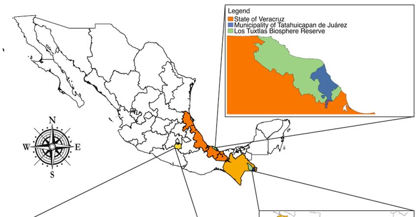
Land 2021, 10, 1340                                                                                           2 of 24

                      itiatives have not achieved their goals of restoring millions of hectares and reducing de-
                      forestation due to a variety of socio-environmental and political factors [1–5]. Heads of
                      environmental and agricultural ministries involved in these initiatives have blamed this
                      on drought, food security crises, and unproductive agricultural practices [6,7], failing to
                      acknowledge the impact of expansion of cattle-raising, agroindustrial plantations, urban-
                      ization, and extractive mining and oil companies. Such industries have created a market
                      for land, dispossessing indigenous and peasant communities [8–11]. As a result, regener-
                      ation in these landscapes is threatened by communities’ loss of land tenure rights, land
                      tenure conflicts, land market pressures, commercial plantations, livestock expansion, ille-
                      gal logging, and top-down environmental and agricultural policies [9,10,12–16].
                            Achieving goals of restoring millions of hectares during the UN Decade on Ecosys-
                      tem Restoration (2021–2030) will not only be very costly but also highly uncertain due to
                      the opportunity cost of land, land-use change, forest fires, dense human populations in
                      some regions, rural poverty, biophysical and ecological limitations, and challenges to food
                      security [5]. Despite investment in reforestation, many national governments and interna-
                      tional institutions have failed to promote landscape regeneration through natural re-
                      growth [4,5,17], mainly due to its low political impact as compared to that of reforestation.
                      While agricultural land under transition to forest is likely to recover its structural proper-
                      ties, species composition, and socio-ecological functions, studies suggest that transition to
                      mature secondary forest requires at least 50 years, depending on environmental condi-
                      tions [18–21]. Natural forest regeneration is part of the cycle of traditional agricultural
                      systems involving rotation between crops and forest. Until the 1990s, regeneration and
                      cultivation constituted an integrated system [22–25]. Nevertheless, social, economic, po-
                      litical, and environmental vulnerabilities1 of indigenous communities, as well as increas-
                      ing intensification of land use, have hindered natural regrowth.
                            The concept of vulnerability is key to understanding the multidimensionality of re-
                      generation, regrowth, and reforestation, as each of these processes involves environmen-
                      tal, social, economic, political, and cultural threats. While initially applied to hazards and
                      disasters [26,27], this concept provides a theoretical framework for understanding peo-
                      ple’s relationships to their environment, taking into account social forces, power relations,
                      institutions, and cultural values that promote or impede conservation, reforestation, and
                      natural regeneration. Eleven forms of vulnerability—biological, ecological, physical, eco-
                      nomic, social, political, technical, ideological, cultural, educational, and institutional vul-
                      nerability— have been identified [28], providing a framework for analyzing chains of cau-
                      sality [29] that foster natural regeneration. Despite these threats and vulnerabilities, for-
                      ests are regenerating in many countries, resulting in multi-functional landscapes
                      [1,4,30,31], which not only provide economic benefits but are also restructuring cultural
                      relationships within indigenous and peasant communities. Currently, there is a need for
                      national policies to confront multiple interrelated social, economic, and political threats to
                      natural regeneration in rural communities [3–5].
                            In Mexico, the combination of agricultural intensification, expansion of cattle raising,
                      transformation of land tenure regimes, urbanization fostered by tourism, and top-down
                      forest policies have contributed to the inhibition of long-term forest regrowth and land-
                      scape regeneration [15,32]. Initial evaluation indicates that 3,149,631 ha were reforested
                      throughout Mexico from 2001 to 2015 [33], although long-term monitoring of plant sur-
                      vival and growth is lacking. However, 3,208,011 ha were deforested during the same pe-
                      riod [34]. Considering that only 60% of reforestation lasts more than 10 years, deforesta-
                      tion is winning the battle. Reports on natural regeneration have been sporadic and are not
                      easily available [35,36].
                            Understanding rural vulnerabilities and threats—including food insecurity; rural mi-
                      gration; sale of ejido and communal land2; poverty and socio-economic inequity; and land-
                      cover change to pasture, commercial monocultures, and urbanization—requires a mul-
                      tiscale analysis and a multi-situated ethnography [37]. We analyze three case studies to
                      illustrate vulnerabilities that often result from national policies and globalization through
Land 2021, 10, 1340                                                                                         3 of 24

                      markets and capital flows, which are common in indigenous Mexican and other peasant
                      communities. We focus on socio-cultural, economic, and political vulnerabilities and
                      threats that hinder rural communities with contrasting cultural and political contexts and
                      socio-economic pressures from achieving continuous vegetation regrowth and forest re-
                      generation. While the populations of the three case studies were originally indigenous,
                      since the 1950s, they have undergone cultural transformations, as many mestizo rural
                      families have immigrated to these communities and because many community members
                      have migrated to the US or Canada as temporary or permanent workers.

                      1.2. The 1992 (Counter) Agrarian Reform: A New Land Market
                            With Mexico’s 1992 Counter-Agrarian Reform, Article 27 of the Constitution was re-
                      formed. The 1993 Agrarian Law allowed for private ownership and sale of previously
                      collective ejido and communal land [38]. Ejido land had been defined as inalienable, un-
                      seizable, indefeasible, non-transmissible, unrentable, and untaxable. Implementation of
                      the Agrarian Law was gradual for the majority of ejidos in Mexico through the “voluntary”
                      Program for Certification of Ejido Rights and Titling of Urban Plots (PROCEDE in Span-
                      ish), which promoted demarcation of ejidos and communal land with the supposed aim of
                      providing legal security to land tenure. This led to modifications in land use and property
                      rights, disintegration of peasant cooperatives, and—especially relevant to our study—pri-
                      vatization of forest land in an effort to liberalize and stimulate the rural economy [32,39–
                      42].
                            Shortly after the reform was implemented, its social, economic, environmental, and
                      patrimonial impacts were not fully evident. Despite predictions that privatization sig-
                      naled the end of the ejido, most ejidos did not quickly opt for privatization of common-use
                      land [43]. However, almost 30 years later, it is evident that this counter-reform reversed
                      the post-revolutionary 1917 constitution, which protected peasant land from open market
                      competition, preserved continuity of peasant land, and granted the State—rather than the
                      market—the principal role in regulating economic, political, and social relations of ejidos
                      and communal landholdings, fomenting their development through loans, technical as-
                      sistance, and provision of agricultural inputs [42,44].
                            As a prerequisite for signing the 1994 North American Free Trade Agreement
                      (NAFTA), Mexico’s 1992 reform allowed for sale of rural land. While the expected impacts
                      on the land market have taken longer than predicted, the effects of the sale of ejido and
                      communal land have been recently devastating in some regions. Prior to 1992, ejido and
                      communal lands were occasionally sold despite constitutional stipulations; however, pur-
                      chasers were generally from the same ejido or communal landholding, and sale was ap-
                      proved by the communal or ejido commissioner, and in most cases, it had to be approved
                      by the assembly, thereby providing for community control over land sales.
                            Until 2010, very few studies addressed changing patterns in forest cover resulting
                      from the counter-reform. However, some studies of the relationship between land tenure
                      and landscape changes [15,16,32] have shown that privatized ejidos tend to have more land
                      being used for agriculture and higher deforestation rates than commonly held ejidos, many
                      of which have furthermore obtained economic benefits through community forest man-
                      agement [32,45]. Nevertheless, the type of land tenure per se is less of a driver of land-use
                      changes than the fragility of institutional arrangements that structure land tenure and the
                      extent of accumulated vulnerabilities in rural communities.

                      1.3. Case Studies in Veracruz, Chiapas, and Morelos
                           The first case is the ejido of Tatahuicapan in the municipality of Tatahuicapan de Juá-
                      rez of southern Veracruz in the Sierra of Santa Marta, which covers approximately 1500
                      km2 and forms part of the Sierra of Los Tuxtlas (Figure 1). Since pre-Hispanic times, the
                      population was of Popoluca and Nahua origin, but in the 1950s and 1960s, government
                      programs brought waves of mestizo migrants from central Veracruz and other regions of
Land 2021, 10, 1340 4 of 24
central Mexico [46–48]. The municipality’s 62 villages cover 295.8 km2, with a population
of 16,369 in 2018 [49]. The ejido of Tatahuicapan, founded in 1966, covers 8361 ha.
Figure 1. Map of the three case studies in Veracruz, Chiapas, and Morelos, Mexico.
Due to the coastal location of the Sierra of Santa Marta; its altitudinal range from sea
level to 1700 masl (including the volcanoes of Santa Marta, San Martín Pajapan, and San
Martín Tuxtla); and its humid tropical climate (annual average precipitation >4000 mm),
many vegetation types are found, with a predominance of rainforest, cloud forest, and
pine-oak forest in various stages of succession. The convergence of two biogeographical
regions (Neartic and Neotropical) explains its great biological richness and high plant en-
demism [50,51]3. For this reason, in 1980, it was declared a Forestry Protection and Wild
Fauna Refuge Zone, and in 1998, the Los Tuxtlas Biosphere Reserve.
Largely due to landless mestizo rural migration, international loans, and low maize
prices, this former agricultural region transitioned to cattle raising [52–54]. In the 1960s,
tropical regions of Mexico, including parts of the states of Veracruz and Chiapas, were
included in federal programs4 encouraging peasants from central Mexico to settle and
clear the land. In the 1970s, Interamerican Development Bank programs promoted live-
stock raising [46,55,56]. Consequently, cattle raising has become a severe threat to rainfor-
est conservation [46,57].
The second case is the municipality of Marqués de Comillas in eastern Chiapas (Fig-
ure 1), whose original inhabitants were mainly of Mayan origin. The region was largely
uninhabited until 1967, when the federal government declared over 400,000 ha as a federal
property suitable for colonization [58]. A government program by the Echeverría admin-Land 2021, 10, 1340 5 of 24
istration (1970–1976) encouraged immigration to occupy Mexico´s southern border re-
gion, catalyzing drastic land-cover change [59,60]. The region´s first ejidos were estab-
lished next to the Lacantún River, bordering the Montes Azules Biosphere Reserve, estab-
lished in 1978. The population increased rapidly during the 1970s and 1980s [61], as 10,000
peasants, mainly from southern Mexico, settled the area [60,62,63], converting rainforest
to agricultural land [61].
The municipality (92,242 ha) currently contains 28 localities, of which only 22 are of-
ficially registered [64]. From 2000 to 2020, the population increased from 8580 to 12,892.
According to Mexico´s Social Development Policy Council, 92% of the population falls
under the poverty level, 80% of whom rely on agriculture [65]. The population increase
was the principal driver of deforestation during the settlement period, when forest re-
growth was nonexistent. In the mid-1980s, Marqués de Comillas was still practically cov-
ered by rainforest [59]. However, during the 1990s, economic factors (e.g., markets) and
public policy spurred environmental changes. An unsuccessful Forestry Management
Plan led to the sale and distribution of common-use land, further deforestation, and forest
fragmentation. The 1994 Program for Direct Agricultural Support (PROCAMPO) pro-
vided agricultural subsidies to farmers cultivating at least five hectares, further accelerat-
ing the agricultural conversion of secondary vegetation and rainforest. Despite these pro-
grams, the Montes Azules Biosphere Reserve still contains Mexico´s largest rainforest.
The third case is the municipality of Tepoztlán in the northern region of the state of
Morelos, consisting of eight communities. Most of its territory is protected by either the
Tepozteco National Park, created in 1937, or the Chichinautzin Biological Corridor, cre-
ated in 1988. Tropical dry forest, oak, pine-oak, and pine forests are found along a broad
altitudinal gradient (1230–2350 masl).
The communal land of Tepoztlán, which had been taken over by the Oacalco Haci-
enda, was returned to the eight communities in 1929. However, the entire area of 23,800
ha was given to all comuneros (peasants with legal rights to land), instead of dividing it
among each community, resulting in continual conflict, as decision making and infor-
mation have been concentrated in the municipal seat of Tepoztlán. Although the borders
of each community are generally respected, an imbalance of political and economic power
arises due to the lack of independent status for each community. This is the case of Ama-
tlán de Quetzalcóatl, which consists of 2610 ha and had a population of 1029 in 2010 and
1312 in 2020. Historically, authorities and individuals from Amatlán have had to negotiate
with communal authorities of Tepoztlán under unequal conditions, and funding from
government programs has not always been clear and equitable. Changes in land tenure in
Amatlán must be sanctioned by the communal commissary of Tepoztlán (which legally
represents all communities), as well as municipal authorities.
During most of the 20th century, peasants of all communities of Tepoztlán cultivated
their land and worked seasonally in sugar plantations, but the introduction of tourism in
the late 1980s significantly transformed the municipal economy.
2. Methods
For several years, the authors have promoted alternative community development
according to the principles of participatory action research. Qualitative data were gath-
ered regarding community members´ perceptions of ecological, socio-cultural, and eco-
nomic transformations related to land-use change.
In Veracruz, from the mid-1990s to 2001, the first author worked with Nahua families
to transform extensive cattle raising—which began in the 1950s—into holistic cattle rais-
ing, which allows for conservation of patches of successional vegetation and a series of
interconnected biological corridors [46,48,54,66,67]. In June and July of 2019, the author
and a team of students evaluated long-term and more recent vulnerabilities and threats
that communities have faced while trying to conserve the rainforest. For this, 60 structuredLand 2021, 10, 1340 6 of 24
interviews of ejido members of Tatahuicapan and 15 open interviews with ejido and mu-
nicipal authorities, teachers, and elders of the community were carried out. Furthermore,
focal groups with young people were organized to discuss their community´s future.
The second author has worked in the Lacandona region of Chiapas since 2006, alt-
hough the relationship with local communities was established several decades ago by a
non-governmental organization with which she works. In 2006, she began working with
the farmers through an ecological restoration program following a multiscale perspective
[68]. On a regional scale, key sites for recovery of biological connectivity were identified.
Priority sites for conservation and restoration were selected in workshops with ejido mem-
bers [69]. Finally, on a plot scale, specific restoration plans were designed according to site
characteristics and the willingness of landowners [70,71]. Interviews were carried out with
72 farmers on local climate change, rainforest transformation and restoration, and man-
agement practices. Different restoration strategies were implemented and evaluated over
the years [72,73]. Ecotourism and handcrafts complemented ecological restoration.
The third author began to work in Amatlán in 2011, when a group of comuneros asked
her for advice on establishing a rural nursery and implementing reforestation. Fieldwork
was conducted with a group of undergraduate and master´s students to monitor refor-
estation and to carry out surveys of vegetation [74,75] and birds [76]; environmental edu-
cation projects [77]; and studies of native species propagation, land-use/land-cover change
[78], and agricultural practices [79]. Based on resulting information, environmental edu-
cation and ecotourism materials were developed. Information on agricultural practices
was obtained through interviews with 30 peasants from April 2017 to February 2018. Focal
groups were organized to gather information regarding territorial use and public policies
[80]. Additional interviews were conducted in August 2021 regarding land tenure rights
and community members´ perceptions of abandoned agricultural fields (acahuales) and
reforestation programs in the community.
3. Results
3.1. Can New Land Markets, Natural Regeneration, and Community Political Institutions
Coexist with the 1992 Agrarian Reform?
As a result of the 1992 Agrarian Reform´s modifications of property rights, in recent
years, land sales have increased in the three study areas, impeding natural regeneration
of secondary vegetation.
Shortly after the reform, ejido members of Tatahuicapan were pressing for regulation
of their land, and little land was sold. Nevertheless, land sales have increased as the ejido
has become a commercial center for the Sierra region. In Tatahuicapan, while 486 ejido
members were recorded in 1995 [46], the most recent census recorded 767 members [81].
The majority of recent members came from the oil-producing cities of Coatzacoalcos and
Minatitlan, Veracruz to raise cattle. Transformation of their plots into pastures has coun-
teracted natural regeneration and maintenance of biological corridors, threatening re-
maining patches of rainforest and temperate forest in Los Tuxtlas Biosphere Reserve.
Ejido land purchase has involved political and socio-environmental transformation
of the ejido. Most recent ejido members do not respect community assembly agreements,
nor do they wish to conserve community forests. The ejido Commissioner (interview, July
2019) commented on this political transformation:
“People from Coatzacoalcos are buying the land, and now they are the new ejido mem-
bers. Having money allows them to pay for two or three plots, and they set the price.
Formerly, ejido members were native to here and participated in the assemblies; the ma-
jority participated. Forty or 50 were missing, but up to 400 met. Not anymore; not even
a fourth of them come. That takes away our strength. If we want to fight to defend our
water and our forests, we don’t have the strength anymore, with so many people from
elsewhere who don’t care about our land. They don’t even live here. They just pay a bigLand 2021, 10, 1340 7 of 24
sum, so somebody takes care of their cattle, but they rarely come. They just buy the land
as business”.
The Commissioner mentions three processes that threaten forest regeneration and
conservation. First, land purchase by people from outside the ejido raises the price of land,
which, as a result, is increasingly purchased by people from elsewhere. Second, they pur-
chase land to establish pastures for cattle raising. As they do not raise crops, they fail to
respect the fallow of the agricultural cycle that allows vegetation to recover. Furthermore,
during ejido assemblies, they tend to impose their interests, which do not include forest or
biodiversity conservation. Finally, as the practice of ejido assemblies has declined, local
regulation of land use and forest conservation is not enforced.
Meanwhile, elder ejido members—many of whom are ill and unable to pay wage la-
bor to replace that of their children who have left the community in search of paid work—
face difficulty in cultivating their land. Additionally, many of their children who have
migrated wish to sell the land. This has led to family conflicts, as those adult children
remaining in the community still wish to work the land, whether cultivating it or trans-
forming it into pasture [82]. These factors place pressure on forests.
In Marqués de Comillas, before 1992, while land could only legally be passed on to a
single son, ejido members could not legally sell or rent land. Nonetheless, it was occasion-
ally sold to other ejido members [83]. However, as of 1992, PROCEDE allowed ejido mem-
bers to divide and privatize communal land, thereby dismantling the ejido [44,84]. In 2000,
land sales began to increase. Since then, ejido land tenure has decreased from 95 to 77% of
the community’s land [81]. Land sales have affected resource management, reducing for-
est regeneration. Large land extensions purchased by people outside the region who lack
interest in forest conservation have been transformed into extensive pastures. These large-
scale farmers often make arrangements with smaller-scale farmers who lack capital, rent
their land, raise a few cows, and cultivate as little as two of their approximately 20 ha [85].
Aside from regulatory changes, regional markets have also fomented these larger land-
holdings, cattle herds, and greater use of agricultural inputs and infrastructure. The vul-
nerability of farmers to price fluctuations in regional markets varies according to the size
of their landholding, and small-scale farmers have fewer opportunities to participate in
these markets. While natural regeneration could be promoted on their land, many of them
have rented their land to large-scale cattle raisers.
This phenomenon has led to internal conflicts in the ejidos of Marqués de Comillas.
Due to the removal of the original land market regulations, fragmentation of the remain-
ing natural ecosystems through sale of land to non-ejido members impedes decision mak-
ing in assemblies regarding communal land use.
Finally, ejido authorities and the organization within the ejido were historically un-
dermined by State control of funds, domination by ejido authorities, and peasants´ de-
pendence on federal subsidies, weakening the collective property regime and impeding
natural-resource management [69]. In this context, some ejido authorities are increasingly
bribed to make and implement land-use regulations, determining who receives govern-
ment subsidies.
In 2008, the Program for Payment for Environmental Services was implemented in
the region by CONAFOR (Mexico´s National Forestry Commission), CONANP (National
Commission for Natural Protected Areas), and the directors of the Mesoamerican Biolog-
ical Corridor. These programs fomented organic farming, agro-silvopastoral systems, eco-
tourism, and community forestry. The Special Program for Conservation, Restoration, and
Sustainable Use of the Lacandon Forest was created in 2010 to protect the region’s biodi-
versity through maintenance and restoration of habitat by detaining deforestation, con-
serving remaining forest cover, recovering degraded areas, improving soil and water
quality, conserving carbon sinks, and generating income, for example, through coffee ag-
roforestry systems [86]. While forest regrowth occurred in some areas [83,87], this pro-
gram has been strongly criticized for promoting commodification of ecosystem services,Land 2021, 10, 1340 8 of 24
thereby oversimplifying the value of—and separating humans from—nature [83]. There
has been no monitoring of forest regrowth due to natural regeneration.
In Tepoztlán, Morelos, since the increase in tourism in the late 1980s, investors, as
well as individuals from the state capital of Cuernavaca and Mexico City, attracted by the
natural beauty of the landscape, began to purchase land to build weekend homes and
hotels. Land purchase accelerated following the counter-reform, and in the 1990s and the
beginning of the 21st century, public policy prioritized tourism. As a result, the urban area
increased by 97% from 1985 to 2015, and the population increased by 217% from 1980 to
2010 [78,88]. Meanwhile, agriculture declined as many farmers started working in con-
struction, commerce, and tourism.
In Amatlán, currently fewer than 50 comuneros cultivate crops, usually 1–2 ha per
family. However, the majority of their income is derived from commerce, tourism, and
construction in the community or in Tepoztlán. Migration to Canada for temporary work
has also been a significant source of income since the mid-1970s. Those who practice ag-
riculture tend to have a greater level of food security and maintain native corn varieties,
which are highly valued for their food value. Some farmers still plant milpas (intercrop-
ping of maize, beans, squash, and other annual crops), but most plant only corn, and some
no longer plant at all. As one community member states:
“It’s more expensive to produce your own corn than to buy it. The price of maize is low, and
you need to invest a lot of work and money to produce it”.
Since most of the land is within the natural protected area, crop agriculture and cattle
raising are only practiced in regulated zones dominated by patches of tropical dry forest
on plains and gentle slopes. Some farmers expressed concern over the future of agricul-
ture, as it is not profitable, and few government subsidies are provided. Furthermore,
many of their children no longer work in agriculture.
Most high-quality fields are cultivated each year or left fallow only one or two years,
and thus, regeneration does not occur. Some temporary migrants in Canada and the US
continue to pay relatives and others to cultivate their land, as do a few women residents
who own land, usually through family members. This allows them to maintain their land
rights and provide high-quality corn for their families. However, some rocky former ag-
ricultural land or that with low-quality soil is no longer cultivated and is undergoing nat-
ural regeneration.
Market pressure is increasing on both agricultural and protected land, as well as on
that undergoing natural regeneration. Most land in the town of Tepoztlán has been ceded
to tourism and urbanization, and the land market is now pressuring nearby communities
with natural scenery, such as Amatlán.
3.2. Land-Use Change and Land-Use Competition
Changes in forest cover and land use result from multiple factors, which vary accord-
ing to the socio-economic, cultural, and ecological context. In Mexico, in the past four dec-
ades, more vegetation has been lost in tropical and cloud forests (in some regions, up to
80% of cover) than in temperate forests (approximately 50% in some regions; 56). Since
2005, federal livestock-raising programs, such as PROGAN (Program for Sustainable
Livestock Production and Beekeeping), have been promoted in southern Mexico. Those
states in which the most funds have been invested by PROGAN are Veracruz and Chia-
pas—each with over 60,000 farms benefitted—and Chiapas—covering almost 30,000
farms [89]. Veracruz and Chiapas have also been subject to government reforestation pro-
grams. From 2000 to 2017, 312,571 ha were reforested in Veracruz—particularly from 2005
to 2008 [90]—while in Chiapas, 209,322 ha were reforested. No data are available regard-
ing natural regeneration.
In the case of Veracruz, in the late 1970s, livestock raising began to extend to ejidos.
While in 1960, 75% of cattle were owned by farmers with over 5 ha, by 1990, 43% were
owned by those with less than 5 ha [46]. With such rapid land-use change in the 1970s and
1980s, close to 40% of what is currently the Los Tuxtlas Biosphere Reserve was deforestedLand 2021, 10, 1340 9 of 24
[91]. Following the establishment of the reserve in 1998, a reduction in deforestation—and
even net forest regeneration—took place, and by 2003, reforested and naturally regener-
ated areas had surpassed the deforested area. However, from 2003 to 2016, deforestation
again increased at an annual rate of 1% [92]. Thus, since 1998, a fluctuation has occurred
between deforestation and reforestation (Table 1). From 2006 to 2011, 643 ha were refor-
ested in the reserve, and from 2011 to 2016, 1088 ha. Nevertheless, from 2006 to 2011, 1156
ha were deforested, and from 2011 to 2016, only 621 ha [92]. Thus, transitions in land-use
change have been dynamic and complex (Table 1). While riparian vegetation, rainforest,
and secondary rainforest have been transformed into grassland, transition from grassland
to cropland and secondary vegetation has also been recorded. From 2011 to 2016, 876 ha
were transformed from grassland to secondary rainforest, but a larger amount was trans-
formed from secondary vegetation, rainforest, and cloud forest into grassland (625, 490,
and 184 ha, respectively). This indicates continual shifting between deforestation for live-
stock raising and regeneration during years of drought or low livestock prices, when
ranchers sell cattle, and grasslands are left to fallow. Despite this, there is a tendency to-
ward a net increase in grassland (988 ha from 2006 to 2016) and cropland (573 ha during
this period) at the cost of forest cover [92]. By 2011, grassland accounted for 51% of the
reserve’s territory; meanwhile, the various successional stages of rainforest made up only
35% [93]. The reduction in the deforestation rate may be attributed to the inaccessibility
of forested areas in steep, rugged areas, which are less apt for agriculture (Table 1).
Table 1. Deforested and reforested surface area: nationwide, Chiapas, Morelos, and Veracruz.
Area Defor-
Area Refor- Area Refor- Area Refor- Area Refor-
ested Na-
Year ested Nation- ested Area in ested in More- ested in Vera-
tionwide
wide (ha) Chiapas (ha) los (ha) cruz (ha)
(ha)
2000 225151 3594 5438 16812
2001 79672 164823 646 4737 12208
2002 191071 224772 9361 3345 15615
2003 185741 186715 7042 6422 21241
2004 135953 195819 6843 2304 15093
2005 170421 182674 6902 2684 25299
2006 98853 212675 11215 3529 26386
2007 131822 341376 17669 3623 3817
2008 192631 373003 16337 5292 25641
2009 301792 176906 11716 5095 18958
2010 220489 136123 22219 2823 15257
2011 282431 231256 18946 774 3099
2012 324262 375706 17576 6596 24633
2013 254855 121005 11182 4741 9652
2014 342899 128086 16354 6255 4987
2015 295119 98692 12823 5801 3846
2016 350298 9198 4723 5241
2017 3884 2808 1389
Total 3558309 3374782 209322 81148 312571
Source: CONAFOR (2020). Estimación de la tasa de deforestación en México para el periodo 2001–2018
mediante el método de muestreo. Technical document. Jalisco, Mexico. SEMARNAT. 2016. “Compen-
dio de Superficie Reforestada” Available at: INEGI. 2021. “Tepoztlan, Morelos”
Available at: www.inegi.org.mx/app/areasgeograficas/?ag=17020> INEGI. 2021.”Chiapas” Availa-
ble at: INEGI. 2021. “Veracruz”Land 2021, 10, 1340 10 of 24
Available at: https://www.inegi.org.mx/app/areasgeograficas/?ag=30> (Accessed on 11 October
2021).
The municipality of Tatahuicapan has followed the rest of the Sierra´s tendency of
deforestation. While in 2005, 50% of the municipality’s territory was covered by rainforest
and its successional stages [49], in 2019, only 30% remained (interview with ejido Commis-
sioner, 2019). Under the hegemonic mestizo culture, Nahua farmers of Tatahuicapan grad-
ually became small-scale cattle raisers through mediería5 contracts with large-scale mestizo
cattle raisers from nearby communities. This was largely a result of a lack of agricultural
loans, low maize prices, lack of cash flow, climatic variation, uncertain harvests, and scar-
city of labor due to high temporary migration rates, all of which have led to uncertainties
and vulnerabilities for the Nahuas. Therefore, they gradually converted their milpas and
fallows into grasslands for livestock. Thus, livestock raising increasingly impinged upon
cropland and forests, despite being within a natural protected area. Furthermore, a rup-
ture in community political institutions, such as the elders’ council and ejido assemblies
and increasing connections between community authorities and regional political parties,
led to the development of a new political arena dominated by cattle raisers as the most
economically and politically powerful community members [46,53]. Based on 121 inter-
views carried out in 1993, by 1970, an estimated 8% of the large-scale cattle raisers con-
trolled half the area devoted to cattle raising. This land grabbing was disrupted by small-
scale landowners who formed farmer organizations to facilitate receiving loans through
the Livestock Trust (Fideicomiso Ganadero). Several years later, the Rural Development
Bank (Banrural) and the National Indigenous Institute provided financing to promote
livestock raising [46].
Initially, to establish enclosed pastures, farmers felled secondary forests but later ro-
tated their livestock to other areas, allowing vegetation to recover [66], thereby establish-
ing a cycle of pastures and secondary forest. However, in order to receive loans, farmers
were required to establish permanent pastures without secondary vegetation to maintain
their cattle, breaking the cycle of natural regeneration.
Given the current tendencies of land sale and distribution to sons and grandsons,
surface area per domestic group has decreased; while in the late 1990s, average surface
area was 20 ha [46], this has decreased to approximately 10 ha (interview with Inocente,
ejido Commissioner, 2019), of which an average of only 1.1 ha is used to cultivate seasonal
native maize. This shift toward using land for livestock raising—the most profitable eco-
nomic activity despite fluctuations in livestock prices—reduces the possibility of natural
regeneration. As one mestizo from central Veracruz stated:
“I saw the opportunity. We asked for timber permits; we came with the wish to clear the
land and make use of the timber but also with the wish to have our cattle. We had good
harvests, but we didn’t have money. In those days, there was poverty of money. I saved,
but I had to cut everything down to put cattle in. I just left a few trees for shade. We
don’t want to let trees grow because then the grasses don´t grow.”
The traditional extensive management of cattle raising imposed by a variety of fed-
eral programs impedes the possibility of natural regeneration. In 1998, based on our par-
ticipatory work in the community, we advised FONAES (Fondo Nacional de Apoyo para
Empresas en Solidaridad; part of the Federal Economic Ministry) to foster agro-silvopas-
toral systems. While the regional director was interested, the director of FONAES at the
federal level never authorized implementation of this strategy.
In Marqués de Comillas, deforestation occurring during the first 20 years of occupa-
tion (1970–1990) was a consequence of population increase, development policies limited
to promoting extensive cattle ranching [94], and the arrival of approximately 12,000 refu-
gees from Guatemala [58,63], who cleared land in exchange for a temporary space to pro-
duce their food and build a home [58]. While the 1994 National Zapatista Army of Liber-
ation (EZLN) uprising did not occur in the region, it indirectly affected the municipality.Land 2021, 10, 1340 11 of 24
To avoid farmers´ discontent, the federal government removed the tree-felling ban estab-
lished in the early 1990s [63], and in 2000, completed the highway on the border between
Chiapas and Guatemala connecting Palenque and Comitán. This promoted new settlers
coming to the region [62,63] and an increase in agriculture to respond to the demand for
food [61].
This period was characterized by the transformation of rainforests into cropland and
pastures, provoking a loss of biodiversity [95]. Farm families typically had 30 to 50 ha,
mostly used for livestock, with only 1–5 ha of milpa [96], and small areas of forests or
secondary vegetation (acahuales) followed the slash-and-burn process. However, conser-
vation and natural regeneration of these areas greatly depend on the number of family
members, the local land market, and the existence of economic activities that promote
other land uses.
Since the beginning of the XXI century, various government programs have pro-
moted African oil-palm (Elaeis guineensis) plantations [59,97]. By 2010 in Marqués de
Comillas, oil palm covered over 5000 ha, increasing to over 10,000 ha by 2017 [98]. The
federal Productive Reconversion Program (2007–2012) produced approximately three
million palm seedlings in nurseries in palm-growing regions, including Marqués de
Comillas, distributing them at no cost to interested farmers, along with USD 48 per hectare
to foment palm plantations. Subsidies were conditioned on planting 135 to 150 plants per
hectare, which is only possible as a monoculture. Expansion of oil palm promoted the
transformation and even elimination of natural vegetation [97]. While pastureland was
often converted for palm raising, 13% of surface area converted to oil palm was previously
rainforest, and 27% was secondary vegetation [99].
Some communities blocked land purchase for oil-palm cultivation (see Section 3.1),
for example, by allowing the land sale to ‘peasants, like us’ but not to investors [99]. Fur-
thermore, peasant families tended to double or triple land prices for outsiders to discour-
age them from establishing palm plantations. However, the introduction of oil palm in
this region was finally successful because many farmers faced difficulties raising livestock
on poor soil and lacked knowledge concerning management of pastures and acceded to
government programs to promote palm cultivation [85]. Most such programs have fa-
vored large land areas (see Section 3.1). When oil-palm cultivation was introduced in 2005,
it attracted medium-scale farmers, who planted small plots (8–10 ha on average; 85). How-
ever, several farmers sold cattle to invest in larger areas for oil-palm cultivation (over 20
ha). Meanwhile, poorer farmers depended on government subsidies and family labor to
raise palm. Thus, while reconversion of degraded or secondary forests to palm plantations
was mainly an individual economic decision, it was also related to the incorporation of
rural families into agroindustry [99]. All this has led to the loss of peasant control over
land use, and eventually, fewer possibilities for forest regeneration.
The coexistence of various government subsidies that counteract conservation also
indirectly inhibited forest restoration (see Section 3.2, 69). In Chiapas, 209,321 ha were
reforested from 2000 to 2007. From 2006 to 2016, over 10,000 ha were reforested annually;
however, after 2016, less than 5000 ha were reforested each year (Table 1). Nevertheless,
there are no data on natural regeneration. Some collective initiatives, such as ecotourism
and handcraft production, have allowed for conservation and support of forest regenera-
tion [100–102].
The government office that oversees land ownership (Registro Agrario Nacional,
RAN) has no updated list of comuneros from Amatlán; most of those originally listed in
1929 have passed away, and their grandchildren have inherited the land, usually sanc-
tioned by the communal assembly. Some community members have sold land to other
community members, typically sanctioned by the assembly. However, disputes arise over
land ownership in cases in which land rights have been transmitted orally. Although few
people wished to discuss intra-family conflicts over land, some admit they are common,
and legal resolution may take years.Land 2021, 10, 1340 12 of 24
Most interviewees agree there is an urgent need to update RAN’s list of living co-
muneros and extend it to include other family members owning land. Communal author-
ities of Amatlán aim to achieve full independence from those of Tepoztlán, as well as gov-
ernment recognition of their territory’s borders, as organized groups from Tepoztlán oc-
casionally claim land rights to portions of their territory. Other communities are also in
this vulnerable position. Additionally, legal independence among communities would al-
low them to receive funds from government programs that, in the past, have been retained
by authorities of Tepoztlán.
Urban development has skyrocketed since the 1990s. Recognition of Tepoztlán as a
“magic town” in 2002 by the government program Pueblos Mágicos (magic towns), de-
signed to promote tourism in small traditional towns [103], led to a further increase in
weekend tourism and the construction of many small hotels. As a result, the urban area
of Tepoztlán and nearby communities increased by 57% from 2005 to 2015 [78,88]. From
2005 to 2011, 4.01% of the municipality’s surface area covered by secondary vegetation
and 5.23% of agricultural land became human settlements, and from 2011 to 2015, these
numbers were 3.59% and 5.65%, respectively [78]. At present, the urban area is 834 ha
larger than that established in the Tepozteco National Park´s management plan [88].
As a result, land prices have increased dramatically, from USD 10/m2 (USD
100,000/ha) in 2005 to approximately USD 75–100/m2 (USD 750,000–1,000,000/ha) in Ama-
tlán, making clear land titles even more necessary to avoid family disputes, given the
higher stakes of selling. This increase in land prices also makes it extremely difficult to
maintain land for agriculture and natural regeneration. As one former communal author-
ity states: “There is a lot of pressure to sell land. We are neighbors to one of the biggest cities in
the world, where big buyers come from. We who understand this problem need to organize and
discuss what to do because as things are going, we natives are going to be displaced if we don´t keep
our farmland.”
Thus, income from land sales makes all other land uses much less competitive, espe-
cially seasonal agriculture, which has a low return on investment, and secondary vegeta-
tion or natural forest regrowth. Some farmers interviewed said that they could maintain
acahuales if they could obtain income from them, for example, through Payment for Envi-
ronmental Services. However, this program currently provides only USD 30–50 per hec-
tare annually to protect forest land [104]. Thus, land market dynamics are clearly promot-
ing land-cover change, threatening the existence of acahuales and their contribution to
landscape restoration.
3.3. Contradictory Environmental Policies: Top-Down Decisions
In Mexico, lack of coordination among government agencies impedes successful in-
tegrated rural policies. Agricultural and environmental policies are often contradictory
and poorly adapted to local ecological, socio-economic, and cultural contexts.
In Veracruz, rural development policies focus on commercial livestock raising and
crop agriculture, without considering the importance of forest conservation or aquifer re-
charge, even in natural protected areas. Since 2005, the principal agricultural program has
been PROGAN for “ejido members, settlers, communal landowners, small-scale landown-
ers, and civil or commercial societies [...] with the right to use land to raise beef and dual-
purpose cattle in an extensive manner” [105]. The majority of livestock-raising units ben-
efitted by this program—38% of all farms in Veracruz—have been in regions of humid
tropical forests [106]. In the municipality of Tatahuicapan, PROGAN was implemented
on 1167 farms on 36,181 ha with a total of 14,568 cows and 835 breeding bulls [107]. This
program does not consider the incorporation of forest management into livestock rais-
ing—quite the opposite; its guidelines specify that natural vegetation must not be allowed
to regenerate so as to not impede growth of grass. While government publications refer
to “sustainable livestock raising” and “restoration of natural resources”, they fail to con-
sider cyclical regeneration between grasslands and forests or secondary vegetation. Loans
and other program funds are provided only if beneficiaries follow the guidelines of well-Land 2021, 10, 1340 13 of 24
managed grasslands and strict control of forests and secondary vegetation, with only two
or three rows of trees alongside rivers and springs to protect water sources. As a result of
criticism of the program, “livestock sustainability” was very recently incorporated, in-
volving a few hectares to protect vegetation and even reforest [107]. Nevertheless,
measures implemented are far from landscape restoration adapted to regional ecological
and socio-economic contexts. Furthermore, PROGAN has never promoted natural regen-
eration to develop ecological corridors.
The federal program Sembrando Vida was implemented in Tatahuicapan in 2019,
with the purpose of promoting food self-sufficiency, complementing annual crops with
fruit and commercial timber trees. However, this program does not include the manage-
ment of secondary vegetation. In fact, in order to provide the 2.5 ha required to participate
in the program, some farmers have cut down their fallows to establish milpa interspersed
with fruit and timber trees. The deforested area resulting from this program has not yet
been quantified.
In Marqués de Comillas, deforestation—initially driven by population increase—has
more recently resulted from public policies and programs with contradictory goals. Aside
from fomenting deforestation, PROCEDE, implemented in this region in 2000, granted
land tenure to ejido members through a certificate of subdivision of farmland. However,
article 59 of the Agrarian Law prohibits subdivision of forested land, whether individual
or communal. In order to obtain their certificate, many ejido members deforested the land
before the program was implemented in their ejido [69].
In 2011, the federal agency CONAFOR implemented the Special Program for Con-
servation, Restoration, and Sustainable Use of the Lacandon Rainforest in Chiapas. This
program provided payment for manual removal of grass in pastures, purchase of seed-
lings, transplanting, maintenance, and restoration of abandoned cropland. However, nat-
ural regeneration and maintenance of already restored sites were not contemplated. While
the program provided funds for five years, this was not enough time for forest structure
and composition to resemble a mature forest, nor had the trees reached the necessary
height to be included in PES, which includes forests with some level of degradation, as
well as secondary forests recovering from agricultural use (typically at least 15 years of
age) to protect biodiversity. Regeneration is not considered a mechanism for restoring
ecosystems. Thus, there is a need for mechanisms that combine restoration with other eco-
nomic activities, such as ecotourism and reforestation.
In Morelos, state conservation, agriculture, tourism, and urbanization policies are not
coordinated. In Tepoztlán, tourism has been the principal driver of the economy and of
land cover change, but its growth has been rapid and unplanned. While the 2013–2015
municipal urban development program promoted “ordered, sustainable urban develop-
ment that promotes social well-being, through definition of clear regulations that encour-
age social, economic and urban development of the municipality” [108], it did not have
the expected impact. The following county development plan (2016–2018) only addressed
security of people and property, without taking into account urban growth. Furthermore,
no new plan has been established, and interviews with municipal authorities in 2018 made
it clear that their focus was limited to promoting tourism, without addressing its environ-
mental impacts on forests, water availability, and land cover, as well as waste disposal.
Thus, urbanization is being left to be driven by the real estate market.
Conservation policies have focused on fire and erosion control, reforestation, and
rainwater infiltration in protected areas. They also aim to regulate tourism in these areas
but lack the necessary personnel and funds to effectively do so. However, the objective of
these programs is not only for environmental protection but also to provide temporary
jobs to nearby residents. They are designed by government agencies (e.g., CONANP and
CONAFOR), and community members’ decision-making power is limited to choosing
which land will be reforested. Program requirements are inflexible and often difficult to
fulfill, as restoration programs require at least 50 ha. For this reason, in Amatlán, comune-
ros have occasionally jointly registered for restoration programs without the consent of allLand 2021, 10, 1340 14 of 24
landowners of the agricultural fields involved. However, through these programs, the
community gains access to temporary jobs, which may appear to be a more urgent need
than restoration.
Several programs have supported commercial agriculture in the municipality of
Tepoztlán, particularly in one community with water for irrigation. Seasonal agriculture,
as practiced in most communities, receives little funding. Input subsidies, for example, for
fertilizer, are usually not provided when needed, so this money is often used to pay pre-
viously acquired debt.
Even protected areas have been threatened by urbanization. Change in land cover
from agricultural fields to human settlements has been considered the principal environ-
mental problem of the Tepozteco National Park [109], fueled by economic pressure and
public policies favoring tourism and land privatization, while cutting funds for agricul-
ture and environmental protection.
Natural regeneration is essential to the recovery of vegetation in protected areas fol-
lowing forest fires. Secondary forests also thrive in former agricultural fields and other
unused land. Satellite images indicate approximately 1100 ha of tropical dry forest in dif-
ferent successional stages in Amatlán that could be incorporated into landscape conser-
vation and restoration initiatives. Of this, only 227 ha have slopes that are suitable for
agriculture. However, no coherent public policies foster inclusion of land unsuitable for
agriculture in large-scale restoration or conservation programs. In the medium and long
term, urbanization poses serious limits to natural regeneration as a tool for landscape res-
toration.
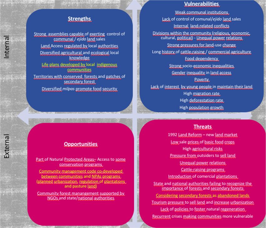
3.4. Strengths, Vulnerabilities, Opportunities, and Threats for Natural Regeneration
Understanding communities’ political, cultural, and socio-economic strengths and
vulnerabilities, as well as external opportunities and threats, is crucial for restoration, par-
ticularly natural regeneration (Figure 2). In the three case studies, the accumulated socio-
environmental vulnerabilities resulting from sale of ejido and communal land, weakening
of communal institutions, and increased socio-economic inequity have resulted in abrupt
land-use change from tropical and temperate forests to pastures, commercial monocul-
tures, and urban areas (Figure 2).
The 1992 agrarian counter-reform favored privatization of land at varying rates, with
a series of consequences. In Tatahuicapan and Marqués, this occurred gradually following
implementation of PROCEDE. In Marqués, 5% of ejido land was privatized by 2007 but
has since increased to 24% [81]. Meanwhile, in Tatahuicapan, privatization began in 2009,
and by 2010, ejido members had sold 5% of their land. By 2019, it was estimated that 30–
40% of the land had been sold. Despite gradual implementation of PROCEDE, livestock
raising accelerated with the 2008 agricultural crisis, increasing deforestation. In turn, land
sale for urbanization in Tepoztlán, which began in the late 1980s, increased significantly
after the counter-reform, even though some communal assembly members decided not to
participate in PROCEDE. At present, most communal land within the town limits of
Tepoztlán has been sold (except the core of the two protected areas), and land sales have
been expanding in nearby communities.You can also read