WALLOWA COUNTY SMOKE MANAGEMENT COMMUNITY RESPONSE PLAN - Approved: March 17, 2021
←
→
Page content transcription
If your browser does not render page correctly, please read the page content below
WALLOWA COUNTY SMOKE MANAGEMENT
            COMMUNITY RESPONSE PLAN

                 Approved: March 17, 2021

1|P a g e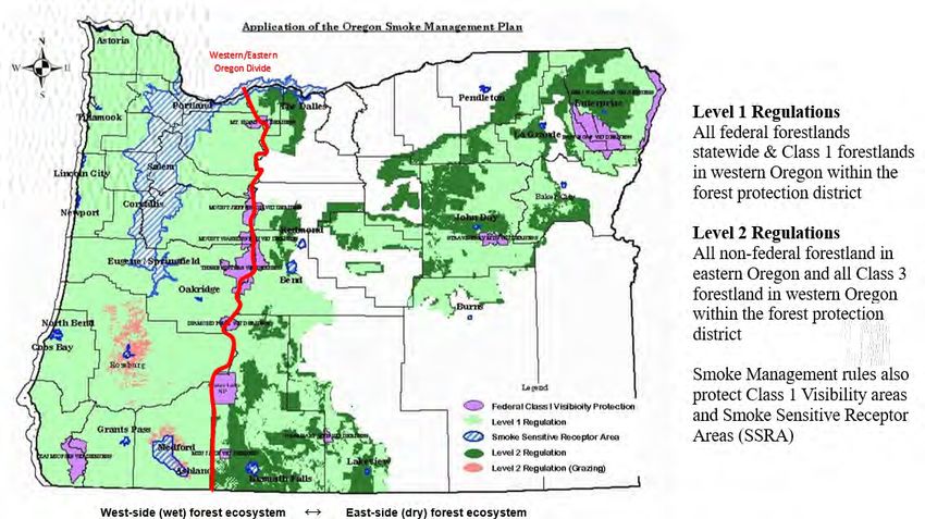
TABLE OF CONTENTS
Declaration of Agreement...................................................................................................................................... 3
Executive Summary ............................................................................................................................................... 4
Rationale for the Wallowa County Smoke Management Community Response Plan............................................. 6
State-Required Components of the Community Response Plan ............................................................................. 7
Description of Smoke-Vulnerable Populations in Wallowa County ........................................................................ 8
Analysis of Fire, Smoke, & Air Quality for the Wallowa County SMCRP ............................................................... 11
             The Health Risks of Wildfire and Prescribed Fire Smoke............................................................................... 11
             Prescribed Fire Smoke & the National Ambient Air Quality Standards (NAAQS) for PM2.5 .......................... 11
             Wallowa County & Enterprise PM2.5 Monitoring ........................................................................................... 13
             Prescribed Fire Smoke and Air Quality in Enterprise .................................................................................... 14
             Wildfire Smoke and Air Quality in Enterprise................................................................................................ 17
Oregon Smoke Management Plan Designations in Wallowa County.................................................................... 18
Partner and Community Input ............................................................................................................................. 19
             Wallowa County SMCRP Design Team .......................................................................................................... 19
             Public Survey ................................................................................................................................................ 19
             Public Input Sessions ..................................................................................................................................... 20
Coordination & Communication Plans for Fire, Air Quality, & Public Health ........................................................ 21
             Wallowa County Preparedness Committee .................................................................................................. 21
            Wallowa County Communities ...................................................................................................................... 22
                          Troy ................................................................................................................................................. 22
                          Flora ................................................................................................................................................ 22
                          Enterprise and surrounding areas in the Wallowa Valley ............................................................... 22
                          Wallowa Lake .................................................................................................................................. 23
                          Imnaha ............................................................................................................................................ 23
             Wallowa County Firewise Communities ........................................................................................................ 23
             Housing Community Contact Information .................................................................................................... 23
Action Items Detailed Procedures ........................................................................................................................ 24
Annual Reporting ................................................................................................................................................. 27
Conclusions.......................................................................................................................................................... 27
References ........................................................................................................................................................... 28
Appendices
            A) Wallowa County Smoke Management Community Response Plan Survey
             B) Enterprise SSRA Map and PM2.5 Monitoring Site
             C) Enterprise Yearly Graphs for Daily Average PM 2.5
             D) Wallowa County SMCRP Survey Results
             E)    Notices from 2020 Public Input Sessions
             F)    Sample Educational Story Published in the Local Newspaper in 2020
             G) Sample Letter to Contractors and Landowners Prior to the Start of Fall Burning Season
             H) Options to Protect Public Health and Mitigate Exposure to Smoke
             I)    Community and Partner Organization Contact Information

2|P a g e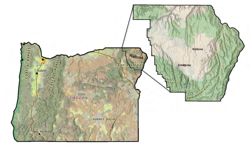
DECLARATION OF AGREEMENT

   The Enterprise City Council, in coordination with the Wallowa County Board of Commissioners, has reviewed
   and approved the Wallowa County Smoke Management Community Response Plan (Wallowa County SMCRP).
   Per OAR 629-048-0180 of the 2019 Oregon prescribed fire Smoke Management Plan, the City of Enterprise and
   Wallowa County jointly agree to submit the Wallowa County Smoke Management Community Response Plan to
   the Oregon Department of Forestry and Oregon Department of Environmental Quality as a formal request for
   exemption from the 1-hour smoke intrusion threshold for the Enterprise Smoke Sensitive Receptor Area.

   _________________________________________________                              ___________________
   Ashley Sullivan, Mayor                                                         Date
   City of Enterprise

   _________________________________________________                              ___________________
   Susan Roberts, Chair                                                           Date
   Wallowa County Board of County Commissioners

   _________________________________________________                              ___________________
   John Hillock, Commissioner                                                     Date
   Wallowa County Board of County Commissioners

   _________________________________________________                              ___________________
   Todd Nash, Commissioner                                                        Date
   Wallowa County Board of County Commissioners

3|P a g e
EXECUTIVE SUMMARY

In the winter of 2021, Wallowa County completed its Smoke Management Community Response Plan with grant
funding from the Oregon Department of Environmental Quality (DEQ). The community response plan will help
protect the health of people in Wallowa County from smoke impacts, while building wildfire resilience through
prescribed burning. The county’s plan followed recommendations from DEQ and the Oregon Department of Forestry
(ODF) and complies with OAR 629-048-0180. The plan also addresses the Smoke Sensitive Receptor Area (SSRA), a
status of its capital city of Enterprise - a community that experiences smoke events - as described in OAR 629-048-
0140.

The City of Enterprise, in conjunction with Wallowa County, has approved the following Wallowa County Smoke
Management Community Response Plan (hereto referred to as the Wallowa County SMCRP), consistent with OAR
629-048-0180. The Oregon Department of Forestry and the Oregon Department of Environmental Quality have
recommended that communities that are Smoke Sensitive Receptor Areas and have experienced repeated smoke
events and/or intrusions in the past, collaboratively develop a community response plan (CRP) and program.
Enterprise is considered an SSRA, under OAR 629-048-0140. Therefore, the intent of this SMCRP is to fulfill that
need for the City of Enterprise, as well as to address planned smoke events for the remainder of Wallowa County.
See Figure 1.0 for a Wallowa County indicator map.

Figure 1.0: Wallowa County Indicator Map. The towns of Enterprise, Flora, Imnaha, Joseph, Lostine, Troy and
Wallowa are shown on the map as well as the location (red) of the Enterprise SSRA.

4|P a g e
The Wallowa County SMCRP includes the following:
    •   A description of the populations in Wallowa County who are vulnerable to short term smoke events,
    •   A notification plan to inform the vulnerable populations and the general public of anticipated smoke events,
    •   A list of options and mitigation measures to protect the health of vulnerable populations from short-term
        smoke exposure, and
    •   A communication plan for the entities that conduct prescribed fire, the local public health authority, and
        the community’s public and vulnerable populations who may be impacted by smoke.

Communities that have developed and implemented a CRP plan may request an exemption from the one-hour
average smoke intrusion threshold. An exemption to the one-hour smoke intrusion threshold means that smoke
impacts that surpass the one-hour threshold, but not the 24-hour average threshold, shall be deemed smoke
incidents, not smoke intrusions, within the SSRA.

The Wallowa County SMCRP will be implemented in the Spring of 2021 and will be included in the request to ODF
and DEQ for an exemption from the one-hour smoke intrusion threshold, as outlined in the Oregon Smoke
Management rules. Obtaining a one-hour intrusion exemption will allow for the expanded use of prescribed burning
in the forests adjacent to the City of Enterprise and other wildland urban interfaces (WUI) leading to a more fire
resilient Wallowa County landscape.

The goals for the Wallowa County SMCRP are to:
    •   Develop an efficient and effective communication and notification system for residents in Wallowa County
        who may be impacted by short-term planned smoke events, particularly the smoke vulnerable populations,
    •   Provide information and mitigation strategies for those in the community who are adversely affected by
        smoke, to cope during planned short-term smoke events, as well as wildfire events,
    •   Allow prescribed fire treatments within the county,
    •   Reduce the threat of major wildfire events,
    •   Improve forest health and resiliency, and
    •   Increase the health and safety of the community and firefighters.

Increasing the ability to conduct prescribed fire treatments within the Wallowa County forests will reduce the risk
of catastrophic wildfires from destroying communities – a real threat realized across the West. Wallowa County and
the City of Enterprise are being proactive in their approach to forest and community health and viability by
implementing the Wallowa County SMCRP.

5|P a g e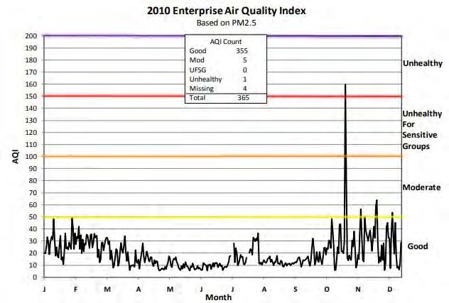
RATIONALE FOR THE WALLOWA COUNTY SMOKE MANAGEMENT COMMUNITY RESPONSE PLAN

The health of residents, visitors and smoke-vulnerable populations in Wallowa County is vitally important, and
ensuring that they experience feelings of wellbeing, a healthy environment, and a high quality of life, is crucial.
Increasing the ability to conduct prescribed fire treatments within the Wallowa County forests will help prevent
catastrophic fire events from occurring. Therefore, Wallowa County has a vested interest in preparing its forests
and community to be healthy and resilient in the face of all fire, both prescribed and wildfire, for the short term and
into the future, by implementing the Wallowa County SMCRP. The overall intent of the Wallowa County SMCRP is
to provide a community plan that allows for more prescribed fire to take place, while mitigating health effects to
smoke vulnerable populations during short-term smoke events.

Prescribed fire is the planned and controlled use of fire by experts under specific temperature, wind, and humidity
conditions. The goal of prescribed fire is to help restore fire-dependent ecosystems, improve forest health, increase
community safety and reduce the risk of catastrophic large-scale wildfires. The focus of the Wallowa County SMCRP
is on smoke from prescribed forestland, both underburn scenarios and pile burns after forestry thinning or logging
projects. The use of prescribed fire intends to reduce fuel loads in an effort to limit catastrophic fires and increase
forest resilience. According to the Central Oregon Fire Info (2020b) page, “Prescribed fire, when used strategically
and repeatedly across larger areas, helps sustain healthy forest ecosystems, reduces the risk of out-of-control fires,
reduces the severity of future wildfires when they do occur, and keeps our communities and firefighters safer.”

For thousands of years, the landscape was managed by Native Americans utilizing controlled burns to manage food
stands, manage hunting grounds, prevent disease and insects, and to promote the overall health of the landscape
(Boyd, 1999; Zybach, 2003). This, in addition to lower intensity natural wildfires, helped maintain healthy forest
stands and supported the natural fire regime, which is critical for some fire dependent plant and tree species.
However, fire suppression during the past 100 years has changed the forest ecosystem and increased fuel loads.
Increased fuel loads can lead to catastrophic wildfires which creates longer and more severe smoke events. The
intent of prescribed burning is to help ensure that the forests can be maintained and viable for future generations.

6|P a g e
STATE-REQUIRED COMPONENTS OF THE COMMUNITY RESPONSE PLAN

The Oregon Smoke Management rules state, that “ODF and DEQ recommend communities that are SSRAs and have
experienced repeated smoke incidents and/or intrusions in the past collaboratively develop a community response
plan and program.” OAR 629-048-0180, Section 2 lists the following required components of such a plan:
        1. A description of populations in an SSRA community that are vulnerable to the health effects of short-
        term smoke;
        2. Adequate means by which the public, especially vulnerable populations in the SSRA community, will be
        notified in a clear and reliable way of anticipated smoke impacts in a timely manner;
        3. Adequate options for protecting the health of vulnerable populations (or helping such populations to
        protect themselves) from short-term exposure to smoke, and;
        4. A plan and program for communications between the entities that conduct prescribed fire, the local
        public health authority, and the community’s public and vulnerable populations who may be impacted by
        smoke.

In addition, the Oregon Smoke Management rules state:
The CRP should be coordinated through the local public health authority, but developed collaboratively with
members or representatives of vulnerable populations, community officials, representatives from entities that have
responsibility for prescribed fire, forest restoration collaborative groups, local businesses and other interested
members of the public. Since Wallowa County does not have a local public health authority, coordination occurred
with the Oregon Health Authority (OHA), local health representatives and public outreach to include smoke
vulnerable populations.

7|P a g e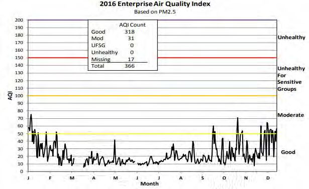
DESCRIPTION OF SMOKE-VULNERABLE POPULATIONS IN WALLOWA COUNTY

Multiple factors can affect a person’s sensitivity to smoke, including their personal health conditions as well as the
severity and duration of the smoke exposure. Smoke can also worsen symptoms in those with pre-existing health
conditions. According to the Oregon Health Authority (OHA), the following are considered smoke-vulnerable
populations:

    •    Persons with asthma or other chronic respiratory diseases, such as COPD and emphysema
    •    Persons with cardiovascular disease
    •    Persons 65 years of age or older
    •    Infants and children
    •    Pregnant women
    •    Smokers, especially those who have smoked for several years
    •    Persons without housing or access to closed-loop air conditioning
    •    Outdoor and farm workers

To obtain information on the smoke vulnerable populations within Wallowa County, multiple data sources were
examined to compile overall demographic data for Wallowa County. The data was examined to gain insight into
how many residents may be more vulnerable during short-term smoke events. The United States Census Bureau
Data from 2019 was analyzed; as well as the 2019 Wallowa County Comprehensive Needs Assessment (Ladendorff,
2019). The Needs Assessment was a joint effort by the Northeastern Oregon Network, the Wallowa Valley Center
for Wellness, Wallowa Memorial Hospital, Winding Waters Medical Clinic, Building Healthy Families, and the
Wallowa County Local Advisory Committee to the Eastern Oregon Coordinated Care Organization, and was
developed to prioritize and incorporate into the action plans and strategies of Wallowa County’s community health
partners, agencies and businesses. We utilized this assessment to review the health needs of the smoke vulnerable
populations who may be at most risk during short term planned smoke events.

Wallowa County’s total population is approximately 7,004. Since 2010 the population rose 2.8 percent. The median
age is 52.6 and continues to rise each year. Table 1.0 outlines the demographic information from the United States
Census Bureau data from 2019, applicable to the Wallowa County SMCRP. Note that individuals may fall into one or
more categories.

8|P a g e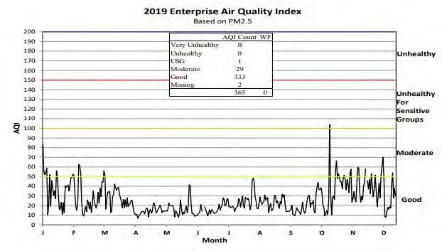
Table 1.0: Wallowa County SMCRP Demographic Information

  Data Category                                                  Total # of people             % of Population
  Total Population                                                     7004
  Persons under 5 years old                                            342                         4.90%
  Persons 65 years old and over                                        1978                        28.20%
  Pregnant Women in 2019                                               105                         1.50%
  Language other than English spoken at home                           187                         2.80%
  Persons with a disability                                            1252                        18.10%
  Persons with a disability under 5 years old                           6                          1.80%
  Persons with a disability over 65 years old                          621                         8.86%
  Persons without health insurance                                     315                         4.50%
  Persons without health insurance age 5 and under                      0                          0.00%
  Persons without health insurance under age 65                         0                          0.00%
  Housing units                                                        4282
  Households                                                           3214
  Households with a computer                                           2778                 86.4% of households
  Households with broadband Internet subscription                      2495                 77.6% of households
  Persons in poverty                                                   941                         13.40%
  Persons in poverty age 5 and under                                    82                         1.20%
  Persons in poverty age 65 and older                                  169                         2.40%
Data obtained from U.S. Census Bureau (2019.) Wallowa County Oregon Profile. Retrieved from United States Census Bureau
data page for Wallowa County, Oregon https://data.census.gov/cedsci/profile?g=0500000US41063

The Wallowa County Comprehensive Needs Assessment (Ladendorff, 2019) provides even more detailed
information for individuals who have health conditions that could make them more vulnerable to short-term smoke
events, including those with asthma, chronic obstructive pulmonary disease (COPD), and cardiovascular health
concerns (Table 2.0). The needs assessment describes community health conditions that are typically worsened by
smoke events.

According to the Oregon Behavioral Risk Factors Surveillance System (OHA 2020) a fewer percent of Wallowa
residents suffer from diagnosed asthma (8.8%) and COPD (3.9%) compared to the population living in the rest of the
state. These data show that the prevalence of asthma and COPD are areas of strength for Wallowa County in the
Needs Assessment (Ladendorff, 2019).

Only 1.9% of the Wallowa County population had ever been diagnosed with coronary heart disease – lower than
Oregon’s average. On the other hand, 4.6% of Wallowa residents have had heart attacks – higher than Oregon’s
average (3.6%). Heart attacks among Wallowa County residents generally occur more commonly than the rest of
Oregon. The Needs Assessment pointed to heart disease prevalence and mortality as an area of average concern for
Wallowa County.

9|P a g e
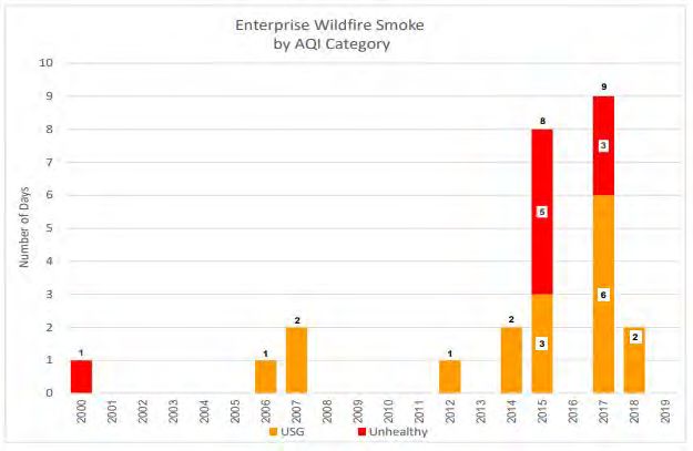
Table 2.0: Wallowa County Chronic Illness Demographic Information

                                                        Wallowa County                            State of Oregon
                   Illness
                                                 Percent of residents diagnosed           Percent of residents diagnosed
   Asthma                                                     6.2%                                     11%
   Chronic Obstructive Pulmonary
                                                              2.5%                                     5.6%
   Disease (COPD)
   Coronary Heart Disease                                     1.9%                                     3.4%
   Heart Attacks suffered                                  4.6% (2016)                                 3.6%
   *Data are age-adjusted rates, may be statistically unreliable, and should be interpreted with caution. Data is from the
   Oregon Behavioral Risk Factor Surveillance System (BRFSS), 2014-2017. Some interpretation comes from the Wallowa
   County Needs Assessment (Ladendorff, 2019).

Overall, 33.1% of Wallowa County’s population falls into a smoke vulnerable category simply based on the age
categories of under 5 or over 65. With the median age of 52.6, the percent of the population that will be 65 and over
in the coming years will most likely increase. Therefore, it is critical to develop good communication and mitigation
techniques when over 33% of the population is potentially vulnerable to smoke events.

In addition to the aforementioned sources, voluntary surveys were distributed via social media, email, and in public
forums throughout Wallowa County during the fall of 2020. The survey helped to gain further insight into the smoke
vulnerable populations, ways residents would like to be informed, what they currently do to protect their health
during smoke events, and what could be helpful to them during short term planned smoke events. The survey, titled
Wallowa County Smoke Management Community Response Plan Survey, (see Appendix A for survey language) was
open to the public September 2 – November 30, 2020. No personally identifiable information was collected in the
survey so all responses were anonymous. The survey is discussed in further detail later in the SMCRP, since the
overall goal was to gain insight into best communication and smoke protection practices. A total of 327 people in
Wallowa County were represented in the survey; and of these, 13 people under age five and 103 people over age
65 were represented. In addition, 28.75% of the respondents stated that someone in their household depends on
a medical device, such as supplemental oxygen, dialysis, wheelchair, CPAP, or BIPAP. A total of 51.25% of the
households represented said that someone in their home suffers from respiratory issues (COPD, asthma, or
allergies), cardiovascular issues, or other conditions that may make them more vulnerable to smoke exposure. A
total of 10% of the respondents stated that they had no health insurance.

10 | P a g e
ANALYSIS OF FIRE, SMOKE, & AIR QUALITY FOR THE WALLOWA COUNTY SMCRP THE HEALTH RISKS OF WILDFIRE AND PRESCRIBED FIRE SMOKE Regardless of the source of smoke, exposure can be hazardous to your health and potentially exacerbate existing medical conditions. A person’s sensitivity to smoke can be affected by the severity and duration of the smoke exposure and the person’s overall health. As previously mentioned, certain groups of people are more sensitive to smoke and need to be especially cautious. Generally, the duration and severity of prescribed fire smoke is much less than that of wildfire smoke. To alleviate smoke impact, state regulations require that prescribed burning take place on days with optimal weather conditions to prevent inversions. On the other hand, wildfire events are uncontrolled and typically consume more vegetation per acre than prescribed fires and are more likely to produce higher smoke emissions for prolonged periods. While all smoke produces poor air quality, wildfires tend to have a larger scale impact to the community than smoke from a prescribed burn. Poor air quality for extended periods of time have consistently corresponded with increased use of healthcare services for smoke-related health outcomes, such as asthma and trouble breathing. OHA estimates that smoke from the 2017 Eagle Creek Fire in the Columbia River Gorge (2 million residents in seven counties) resulted in 96 excess emergency department visits and 9 excess hospitalizations for asthma. During the 2020 Oregon wildfires, statewide emergency department and urgent care visits for asthma-like-illnesses were 25% higher during active wildfires. Wildfire smoke can linger for weeks and can create breathing issues as well as visibility issues for both humans and animals. PRESCRIBED FIRE SMOKE & THE NATIONAL AMBIENT AIR QUALITY STANDARDS (NAAQS) FOR PM2.5 According to DEQ, particulate matter (PM) is comprised of extremely small particle and liquid droplets found in the air. Some of these particulates are a source of pollution and can be harmful for your health, including the particulates from woodstoves, fires, dust, cars, etc. PM2.5 refers to particulate matter that is 2.5 microns in diameter and smaller. PM is measured in micrometers (microns, µm). This size of particulate is especially harmful when breathed in because the natural filters in our bodies cannot trap it. PM2.5 can be inhaled deep into lungs and remain for weeks, which can lead to new health conditions or aggravate existing health conditions such as asthma, COPD, respiratory issues, heart disease, and other cardiovascular issues (Oregon.gov 2020). According to Oregon.gov (2020), “On December 18, 2006, EPA reduced the 24-hour fine particulate matter (PM2.5) National Ambient Air Quality Standard. By issuing this rule, EPA intends to further protect vulnerable individuals from air pollution in communities across the U.S. DEQ plans to work with Oregon communities interested in developing strategies to reduce particulate pollution.” Therefore, the Wallowa County SMCRP is intended to develop strategies to keep Wallowa County communities safe during short-term planned smoke events, that have the potential for releasing PM2.5 and other pollutants into the air. The Air Quality Index (AQI) is a daily index of air quality based on three pollutants regulated by the federal Clean Air Act: ground-level ozone, particle pollution (PM2.5), and nitrogen dioxide (Oregon.gov 2020). It provides information on how clean the air is and potential health risks associated with the air quality. The EPA, DEQ (https://oraqi.deq.state.or.us/home/map), and Lane Regional Air Protection Agency (LRAPA)’s websites update the AQI hourly for each monitoring station in the state. Table 3.0 below shows the current AQI index numbers, corresponding PM2.5 levels, health concerns, and colors that are used to communicate impacts to health from air quality. 11 | P a g e
Table 3.0 The Air Quality Index, breakpoints, and health effects (EPA 2021).
AQI Category PM2.5
AQI Health Advisory
and Color (µg/m3)
Air quality is satisfactory, and air pollution poses little or no
Good 0-50 0.0-12
risk.
Air quality is acceptable. However, there may be a risk for
Moderate 51-100 12.1-35.4 some people, particularly those who are unusually sensitive to
air pollution.
Unhealthy for
Members of sensitive groups may experience health effects.
Sensitive 101-150 35.5-55.4
The general public is less likely to be affected.
Groups
Some members of the general public may experience health
Unhealthy 151-200 55.5-150.4 effects; members of sensitive groups may experience more
serious health effects.
Health alert: The risk of health effects is increased for
Very Unhealthy 200-300 150.5-250.4
everyone.
Health warning of emergency conditions: everyone is more
Hazardous 301-500 250.5-500
likely to be affected.
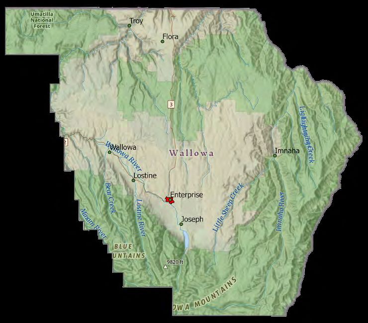
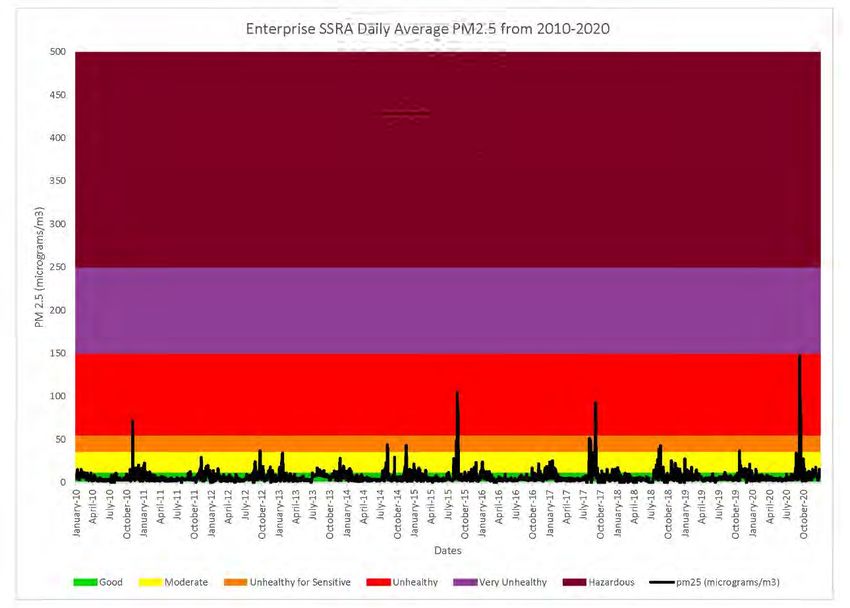
12 | P a g eWALLOWA COUNTY & ENTERPRISE PM2.5 MONITORING There is one AQI monitoring station in Wallowa County, located in Enterprise. The monitor is located on the western edge of the city (Appendix B). This station has been monitoring air quality in Enterprise since July 1, 1994. The monitor station tracks the PM2.5 hourly data in Enterprise. Therefore, there is approximately 27 years of air quality data for the Enterprise SSRA. Figure 2.0 below is a graph showing the PM2.5 daily average air quality data for Enterprise, from 2010 – 2020. Note that very few days in the past 10 years have had air quality in the Unhealthy levels. In addition, there have been no Very Unhealthy or Hazardous days. All the Unhealthy air quality days were associated with wildfire, with the exception of one prescribed fire intrusion that occurred in November of 2010. Figure 2.0: Enterprise SSRA Daily Average PM2.5 from 2010 – 2020. Table 4.0, below, shows the past 18 years of air quality data for Enterprise. It is important to note that the changes to the AQI index occurred in 2012; therefore, comparison may not be completely accurate, but can provide an overall picture of trends. The color codes coincide with the Air Quality Reports rather than the current AQI index. As shown in Table 4.0, over the past 18 years Enterprise has had an average of 26.78 days of Moderate air quality, 1.06 days of Unhealthy for Sensitive Groups air quality, and 0.89 days of Unhealthy air quality a year; based on their monitoring of PM2.5. There has only been a total of 16 days of Unhealthy air quality levels. When analyzing the air quality graphs for the past ten years, the trends show that typically the worst air quality days coincided with summer wildfires or occurred in the winter, when burning piles or wood smoke could be a contribution. See Appendix C for the yearly PM2.5 graphs. 13 | P a g e
Table 4.0 The Air Quality data for Enterprise from 2003 – 2019, based on PM2.5 (Oregon DEQ 2013; Oregon DEQ
                                                      2020c).
                                                     Unhealthy
                                                        for                     Very
                  Year       Good       Moderate                 Unhealthy                 Missing
                                                     Sensitive                Unhealthy
                                                      Groups
                 2003         285           17           0            0           0          63
                 2004         346           15           0            0           0           5
                 2005         332           31           0            0           0           2
                 2006         338           22           1            0           0           4
                 2007         340           21           2            0           0           2
                 2008         341           21           0            0           0           4
                 2009         343           19           0            0           0           3
                 2010         355           5            0            1           0           4
                 2011         342           18           0            0           0           5
                 2012         340           13           1            0           0          12
                 2013         323           41           0            0           0           1
                 2014         329           33           3            0           0           0
                 2015         322           34           3            5           0           1
                 2016         318           31           0            0           0          17
                 2017         291           50           6            3           0          15
                 2018         272           46           2            0           0          45
                 2019         333           29           1            0           0           2
                 2020         323           36           0            7           0           0
                Average      326.28       26.78         1.06        0.89        0.00        10.28
                 Total        5873         482          19           16           0          185

PRESCRIBED FIRE SMOKE AND AIR QUALITY IN ENTERPRISE
Fall and spring are the two main prescribed burning seasons in Wallowa County. In analyzing the Enterprise air
quality yearly data from 2010 – 2020, the best air quality has been from March – June each year (Figure 2.0). There
does appear to be a rise in moderate to unhealthy for sensitive groups air quality from October - January, which
could correspond to prescribed industrial pile burning, as well as wood stove burning, and other non-regulated
backyard burning. However, prescribed burning does not appear to be a significant contribution to unhealthy levels
of air quality in Enterprise. It appears that the fall prescribed industrial burning, when combined with wood stove
smoke and non-regulated outdoor private burning, could contribute to more days of moderate air quality levels in
the fall and winter.

Three smoke intrusions have been noted within the Enterprise SSRA since monitoring began in 1994. In 2010, a
heavy 18-hour smoke intrusion (with AQI levels ranging from Moderate to Unhealthy) occurred on November 4,
from private forestland burning (ODF 2010). Figure 3.0, shows a spike of unhealthy air quality that correlates with
this intrusion.

14 | P a g e
Figure 3: 2010 Enterprise Air Quality Index Summary, based on PM2.5 (Oregon DEQ 2011). Two light smoke intrusions occurred in 2016, one on September 28, which had moderate AQI levels and lasted 14 hours, and then again from September 29-30, 2016, also with moderate AQI levels and lasted 35 hours (ODF 2016). Both these intrusions occurred on USFS property. There does appear to be a slight rise in moderate air quality at the end of September in Figure 4.0 below; however, there are other days of poorer air quality in the fall and winter, that don’t correspond to an intrusion. Figure 4: 2016 Enterprise Air Quality Index Summary, based on PM2.5 (Oregon DEQ 2017). 15 | P a g e
The most recent intrusion occurred on October 24, 2019, on private land and lasted four hours (ODF 2019).
AQI levels ranged from moderate to unhealthy for sensitive groups. The intrusion can clearly be seen as a
spike in poor air quality in Figure 6.0 below.
Figure 6.0: 2019 Enterprise Air Quality Index Summary. Based on PM2.5 (Oregon DEQ 2020).
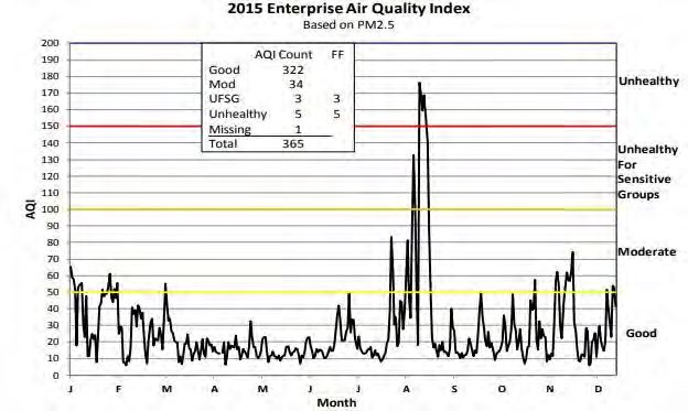
16 | P a g eWILDFIRE SMOKE AND AIR QUALITY IN ENTERPRISE Wildfire trends throughout the state have increased significantly in the past ten years, and subsequently led to more wildfire smoke events. The graph in Figure 7.0 below is taken from the Wildfire Trends and the Air Quality Index publication from DEQ. It shows the upward trends of smoke events associated with wildfire in Enterprise from 2000 – 2019. Figure 7.0: Enterprise wildfire ≥ USG AQI wildfire smoke trends (Oregon DEQ 2020b). Figure 8.0 below shows an examples of air quality in Enterprise on a year with a large wildfire smoke event (2015). In contrast, Figure 6.0 above showed a year without any large wildfire smoke event (2019). Figure 8.0 shows the poor air quality days in July and August of 2015, due to wildfires. Figure 8.0: 2015 Enterprise Air Quality Summary, FF=Forest Fire Impact (Oregon DEQ 2016). 17 | P a g e
OREGON SMOKE MANAGEMENT PLAN DESIGNATIONS IN WALLOWA COUNTY

Wallowa County is located in Northeast Oregon and has land managed under four different components of the
Oregon Smoke Management Plan: Level 1 Regulations, Level 2 Regulations, Federal Class I Visibility Protection Areas,
and a Smoke Sensitive Receptor Area (City of Enterprise). Figure 9.0 below is a map of applications of the Oregon
smoke management plan.

Figure 9.0: Applications of the Oregon Smoke Management Plan

Level 1: All Federal forestland in Oregon falls under Level 1 Regulations. These lands are required to register a
thorough burn plan at least seven days in advance; these plans include how weather will be monitored, identify
appropriate resources to accomplish ignition sequence and control the fire, reduce pre-burn fuel loadings, and how
the burn will minimize smoke entering SSRA’s or other communities. These lands are subject to fee administration,
must follow the Smoke Management forecast instructions, and are required to report accomplishments the next
business day following each day’s ignition.

Level 2: All non-federal forests in eastern Oregon fall under Level 2 regulations. This includes all of Wallowa County’s
private ground, which comprises most of the pile burning in Wallowa County and limited under burns. These lands
are required to register any prescribed burns through the Forest Activity Electronic Reporting and Notification
System (FERNS). Operators and landowners are also required to report accomplishments by the first business day
of the week following ignition but are not subject to fee administration or compliance with smoke management
forecast instructions.

Class I Area Visibility Protection: Wallowa County is host to the Eagle Cap Wilderness and Hells Canyon Wilderness.
Both wilderness areas were designated by Congress in 1977 as federal Class I Areas that are subject to visibility
protection under the EPA’s Regional Haze Rule and the federal Clean Air Act.

Smoke Sensitive Receptor Area: The city of Enterprise is a Smoke Sensitive Receptor Area (Enterprise SSRA).
Enterprise SSRA was given this designation for the highest level of protection under the Smoke Management Plan
and was designated because of past occurrences of smoke incidents and population density. The Enterprise SSRA
vulnerable population is the focus for the development of the SMCRP and the importance to implementing the
actions developed.

18 | P a g e
PARTNER AND COMMUNITY INPUT

WALLOWA COUNTY SMCRP DESIGN TEAM
The Wallowa County SMCRP was developed through a collaborative process involving a diversity of local
stakeholders from City of Enterprise, Wallowa County Commissioners, Wallowa County Emergency Services,
Wallowa Memorial Hospital, Oregon Department of Forestry (ODF), Oregon Department of Environmental Quality
(DEQ), Oregon Health Authority (OHA), and U.S. Forest Service – Wallowa-Whitman National Forest (WWNF). The
team met monthly to bimonthly to develop the process of collecting public input, review any outreach documents,
and provide feedback on the action steps as they were being developed.

PUBLIC SURVEY

In developing the Wallowa SMCRP, a survey was distributed via social media, email, and in public forums throughout
Wallowa County. The survey, titled Wallowa County Smoke Management Community Response Plan Survey, was
open to the public September 2 – November 30. No personally identifying information was collected in the survey
so all responses were anonymous. All the results from the Wallowa County Smoke Management Community
Response Plan Survey can be found in Appendix D.

Eighty people responded, representing 327 residents of Wallowa County. Which represents nearly 5% of the
population. Some notable findings are highlighted below:

•   When asked “What would be the best way for you to receive information when there are smoke events
    expected”:
            o 80% responded social media and/or websites would be best.
            o 40% preferred reverse text or messages
            o 15% listed the radio as their preferred method

                                       Notification Preferences

                         Radio     Message Alert (Reverse Text)   Website     Social Media

•   87% of the respondents use social media or a website to check on air quality.

19 | P a g e
• When asked: “What needs do you have to prepare for or during a smoke event?” Residents responded that
receiving advanced notice was the largest (77%) need to prepare for a smoke event, followed by education on
home air purification (47%) and 28% responded they would like assistance purchasing air purifiers and filters.
Needs to prepare for smoke event
Advance Notice Education on how to keep air clean in house
Assistance purchasing air purifier Education on masks
PUBLIC INPUT SESSIONS
Public input sessions were held in Lostine, Wallowa, Troy, Wallowa Lake, Flora, and Enterprise. Input was
extremely helpful and has been incorporated into the SMCRP to better accommodate the varying communication
needs across the county due to limited access to cell service and Internet in some parts of the county requiring a
multi-faceted approach. Announcements from the public input sessions can be found in Appendix E.
20 | P a g eCOORDINATION & COMMUNICATION PLANS FOR FIRE, AIR QUALITY, & PUBLIC HEALTH
WALLOWA COUNTY PREPAREDNESS COMMITTEE
The Wallowa County Preparedness Committee is a partnership between local health, emergency services,
government agencies, nonprofit organizations, and natural resource professionals. The committee is currently
meeting monthly. During spring and summer, the Oregon Department of Forestry and US Forest Service update the
committee on fire season, including smoke, wildfires, and prescribed fires. This committee connects the members
of our local health care services and organizations which are conducting prescribed burns. Current active members
of the committee represent:
Wallowa County Health Care Providers:
Wallowa Memorial Medical Clinic
Wallowa Memorial Hospital
Winding Waters Clinic
Wallowa Valley Center for Wellness
Alpine Chiropractic Clinic
Winding Waters Clinic
Olive Branch Family Health
Assisted Living Facilities:
Wallowa Valley Senior Living
Pioneer Guest Home
Wallowa River House
Alpine House
Wallowa County Forest Managers:
USDA Forest Service Wallowa Whitman National Forest
Oregon Department of Forestry, Wallowa Unit
Wallowa County Emergency Services:
Enterprise Police Department
Wallowa County Emergency Services
Wallowa County Sheriff’s Department
Partner Organizations & Local Government
Building Healthy Families-Alternative Education
Oregon Health Authority Department of Human Services
Wallowa County Commissioners
Community Connections of Northeast Oregon
Oregon Department of Environmental Quality
Information sent to this committee is dispersed to all the organizations listed above. These organizations
represent many of the vulnerable populations in Wallowa County.
21 | P a g eWALLOWA COUNTY COMMUNITIES Wallowa County sits remotely in the Northeast corner of Oregon. There are three means to entering the county and only two are accessible year-round. Therefore, the Wallowa County landscape has led the outlying communities to develop their own communication chains. During the public outreach meetings, we spoke with local residents from the outlying communities to learn how they communicate in case of emergency or to notify their communities of events happening. We learned about various communications structures set up in these outlying areas of the county. Below we have laid out the communication structures that the communities currently have in place to meet their needs. Troy As a rural town with limited phone coverage, the Troy area has developed their own communication chain to spread news of events. The input from the Troy community explicitly stated that this chain is the best option for spreading the word about any announcements. This effective communication system was also evident when the input session and survey were well promoted. The Troy community has a Facebook page titled, Troy, OR and the Grande Ronde/Wenaha confluence, that is monitored by many of the residents, absentee owners, and frequent visitors. The communication chain process: 1) Post any announcements on the Troy, OR and the Grande Ronde/Wenaha confluence Facebook page and email the community contact. 2) The Facebook page manager then forwards the announcement via email to the community email list, calls those in the area who do not have internet, and contacts the few off-grid landowners without internet and phone. Flora In Flora, word of mouth, by phone or email, is the best way to get information out to the community members. The community contact has contact information for most of the residents; she knows who needs personal calls versus using social media, email, or other internet required services. Enterprise and surrounding areas in the Wallowa River Valley Enterprise, Joseph, Lostine, and Wallowa all have cell phone coverage and access to Internet services. The radio and newspaper are the best sources for locals who do not use Internet. In Lostine, Wallowa, and Joseph most residents are required to have post office boxes, so we recommend using the information boards at these locations along with postings signs at the gas stations and local grocery stores (as permitted by the owners). While this is a simple and less technical way, almost every resident or someone assisting a resident must get their mail, and most residents get groceries and gas locally. 22 | P a g e
Wallowa Lake

The Wallowa Lake area has unreliable cell phone coverage. An effective way to communicate with residents at the
lake is contacting the Wallowa Lake Property Owners Association (WLPOA). The WLPOA has an active email list and
is updating their website to use more often. As the activity on this site grows this will be a great avenue to share
information with the Wallowa Lake Communities.

Imnaha

The Imnaha community is another unique rural community in Wallowa County. The Imnaha Canyon has the small
town of Imnaha at the confluence of Big Sheep Creek and the Imnaha River, and the residents describe the
community as running approximately 40 miles along the Imnaha River. Most landowners have landlines, but not all
homes have access to internet. When speaking with residents there does not appear to be any set notification
structure. Ideas for notifying the community for any potential smoke inversions include a sign at the Imnaha Tavern,
a post on the Imnaha Tavern Facebook page, a sign at the Imnaha post office, calling all residents, or even a sign
posted along the main road in Imnaha. At the time of this plan development there is no set communication
structure.

FIREWISE COMMUNITIES

As the landowners come together to develop their Firewise Communities, a communication structure will be
compiled. Currently, Wallowa County has one Firewise Community, the Lostine Canyon. At the time of this plan
there are two communities in development: South Wallowa Lake and Mount Joseph/Old Ski Run area; and three
neighborhoods interested in becoming Firewise communities: Wallowa Lake West Moraine and North End,
Hurricane Creek, and Troy area. Each Firewise community’s contact list will be housed with landowners within their
communities and with the Wallowa County Firewise Coordinator. Information can be shared with the Wallowa
County Firewise Coordinator to forward to the Firewise Communities. This is an excellent way to spread the word,
announcements, and educational opportunities throughout the county as more Firewise communities are
developed.

HOUSING COMMUNITY CONTACT INFORMATION

The community specific contact list will be housed and updated annually by Wallowa County Board of Commissioners
office and Wallowa County Department of Emergency Services. The list will be reviewed and updated each May to
make sure contacts for partner organizations and communities are up to date prior to fire season and the start of
fall prescribed burning.

23 | P a g e
ACTION ITEM DETAILED PROCEDURES

Information was collected from the public survey, public input sessions, and design team meetings; and compiled
together to create the best laid out action plan for Wallowa County in addressing the smoke vulnerable population
while utilizing prescribed fires to manage our forests. From the beginning of this process, Wallowa County decided
to utilize this plan as much as possible county wide. With over a third of our population falling into the smoke
vulnerable category solely based on age, it is important to utilize education, notifications, and assistance where
needed. The action plan has been broken down into implementation by seasons and by location; separating out
burns that will have potential to affect the Enterprise SSRA and burns located in all other areas of the county.

 YEAR-ROUND EDUCATIONAL OPPORTUNITIES
 These educational activities can be conducted at any time during the year and are targeted to all residents of Wallowa
 County. Some activities, such as the newspaper articles, will have more immediate impact when provided immediately
 before burn season. The responsible party is identified with examples of partners that currently participate in
 landowner and contractor outreach. Many of these natural resource partners were not part of the plan development
 but routinely work with ODF and USFS to provide education to the public.
                                                                 RESPONSIBLE        TARGET
 ACTIVITY                                                                                              TIMELINE
                                                                 PARTY              AUDIENCE
 Host a radio public service announcement about the              ODF & WCDES        All Residents      Annually in the
 upcoming burning season, prior to the start of season,                                                fall, prior to the
 which is determined by the local ODF and US Forest Service.                                           peak of
 These announcements can be utilized to inform the public                                              prescribed burn
 about the upcoming season, landowners and contractors                                                 season
 about any requirements involved with burning, and
 precautions to the vulnerable population.
 Submit press release to local media outlets (Wallowa            ODF Lead           All Residents      Annually in the
 County Chieftain and La Grande Observer, Wallowa Valley                                               fall, prior to the
 Online, Eagle Cap Media, KWVR) in partnership with ODF,                                               peak of
 USFS, and health care providers about prescribed fire.                                                prescribed burn
 Including where to find information about prescribed burns                                            season
 in the area and what to do if there is a smoke intrusion.
 (Appendix F)
 Educate contractors and landowners on the pros and cons         ODF & partners     Contractors & Annually
 of burning (broadcast and pile) and non-burning                 (ex: NRCS, OSU     Landowners
 alternatives (mastication, lop and scatter, biofuels). This     Extension, USFS,
 can be a stand-alone workshop or may fit into one of OSU        SWCD, Wallowa
 Extensions webinar series they host regularly.                  Resources)
 Inform contractors on rules and regulations, how to identify ODF                   Contractors & Annually
 good burn days, and where to obtain air quality data. Add a                        Landowners
 link to this document. An example is attached in Appendix
 G.
 Communicate where controlled burn information will be           ODF & USFS         All Residents      Annually in the
 made available to the public.                                                                         fall
 Educate the public on the importance of utilizing prescribed ODF Lead (ex:         All Residents      Annually
 burns. This is another opportunity for a field trip,            NRCS, SWCD,
 workshop, or online webinar and could be in collaboration       OSU Extension,
 with many of the partner entities that host similar events.     USFS, Wallowa
                                                                 Resources)

24 | P a g e
After controlled burns it is beneficial to show the public the USFS & ODF All Residents Annually in the
benefits and successes of the burns that were conducted. winter or spring
This activity is recommended annually if the opportunity if feasible
arises to demonstrate a positive and successful burn plan.
Provide the vulnerable community representatives and Wallowa County Focus on June/Before Fire
community contacts with information for protecting from Design Team Vulnerable season
smoke (Appendix H) Population
DURING CONTROLLED BURN SEASON
There are different levels of regulations on controlled burns happening in Wallowa County. For the private sector burn
season is year-round, but during declared fire season (June to mid-October) burn permits are required and obtained
from ODF. For federal land managers, each burn plan has a specific prescription based on weather, fuel moistures, and
fire behavior. These burns can be conducted anytime the prescription is met, but in most circumstances the conditions
align during limited times in the fall and spring months. No controlled burning is allowed when a burn ban is in effect.
BURN RESPONSIBLE TARGET
ACTIVITY
LOCATION PARTY AUDIENCE
All Complete all notification protocol currently in place for US Forest USFS Potentially
USFS/Federal Service prescribed burns. Current contacts include: Blue Mountain Affected
Land Burns in Incident Command, Line Officer, Forest Public Affairs Officer, Oregon Residents
Wallowa Dept. of Forestry, Wallowa County Sheriff’s Office, Range Specialist,
County Archaeologist, Adjacent Public & Private Landowners
In addition to the regular contacts, US Forest Service is asked to
USFS/Federal USFS Potentially
contact the Wallowa County Preparedness Committee prior to any
Land Burns Affected
Affecting the burns that may have impact on the Enterprise SSRA. Residents
Enterprise SSRA
Private Smoke Management process that needs to take place when Contractors N/A
Landowner & Private
conducting any burning of forest fuels related to a forest
Burns management activity would include: Landowners
1. Complete a Smoke Management Registration form at least 7 days
prior to burning.
2. Check the Smoke Management Forecast prior to burning to learn
of any adverse weather conditions that would cause smoke to impact
a local community. Follow the recommendations of the forecast.
3. Complete a Smoke Management Accomplishment form daily and
submit the form once weekly as long as burning continues.
25 | P a g ePUBLIC NOTIFICATION SYSTEM
Wallowa County, at the time of this plan writing, was in the transition from Alert Sense to Everbridge. The new
Everbridge system will be up and running prior to Wallowa County’s 2021 wildfire season. After the new system is
online the committee will reconvene to work on establishing a protocol. Currently, the Wallowa County SMCRP Design
Team is the best fit for these tasks. A more permanent committee may be formed in the future to continue the work
of laid out by the Wallowa County SMCRP.
RESPONSIBLE TARGET
ACTIVITY TIMELINE
PARTY AUDIENCE
Compile a comprehensive list of key organizational contacts Wallowa County Vulnerable Annually in the
Populations spring
representing vulnerable population. A beginning list of Board of
contacts is included in Appendix I. Commissioners
Office & WCDES
Establish the new Everbridge Emergency Alert System WCDES Spring 2021
Test Everbridge Emergency Alert System WCDES Spring 2021
Research and decide what levels of notifications are needed SMCRP Team & Fall 2021-Winter
and who is able and responsible to send them WCDES 2022
Advertise & recruit the vulnerable population and public to SMCRP Design
sign up for new notification system Team & WCDES
FUTURE OPPORTUNITIES
Wallowa County has many steps currently in place to help limit smoke intrusions and to protect vulnerable populations
if smoke intrusions do occur, but there is always more that can be done. The ideas below are options brought up by
community members and design team partners for future implementation.
RESPONSIBLE TARGET
ACTIVITY TIMELINE
PARTY AUDIENCE
Air Purifier Distribution Grant Program SMCRP Design Vulnerable Spring 2022
Team Population
Established Social Media Presence SMCRP Design General Fall 2022
Team Population
Establish and maintain an annual calendar of events SMCRP Design General Fall 2021-Winter
Team Population 2022
Develop a list of where information is located to distribute SMCRP Design General Spring 2022
to the public Team Population
Develop a list of social media outlets to determine if there is SMCRP Design Vulnerable
a need for a new platform or if an existing platform would Team Population
be best for hosting prescribed fire information. Currently,
social media pages that are options belong to USFS, ODF,
City sites, Wallowa County, Northern Blue Mountain
Cohesive Strategy Partnership, and other partners
26 | P a g eANNUAL REPORTING As part of the SMCRP and per OAR 629-048-0180 Section 3(f) of the Oregon SMP, the City of Enterprise and Wallowa County are required to annually report the implementation of the SMCRP to ODF and DEQ. In this report the county will document continued compliance with the four required components of the SMCRP. The county will provide a summary of the methods used to communicate to the public and smoke-vulnerable populations a log of dates and times the Wallowa County SMCRP is initiated and a record of local meetings held to discuss or update the SMCRP. Unless otherwise specified, the County will submit annual reports in March of each year, prior to the commencement of each spring prescribed burn season. CONCLUSION Wallowa County has a long history of successful communication and collaboration between the natural resource agencies, community government, and private landowners. Many communities have taken a commitment to address their fire needs through the Firewise program, and the Wallowa County SMCRP is just another valuable resource for creating consistent and timely communication between the organizations. Through the Wallowa County Preparedness Committee, a precedent for communication between various agencies has already been set and can continue. The Wallowa County SMCRP provides a framework for efficient and reliable communication to provide the smoke vulnerable populations of Wallowa County information on potential smoke events from prescribed fire as well as a tool to utilize during wildfire smoke events. This will allow the county to increase the amount of planned forestry burning, which will help restore forest resiliency, while at the same time ensuring the health and well-being of the smoke vulnerable populations and all of Wallowa County. 27 | P a g e
REFERENCES:

Boyd, R., 1999. Indians, Fire and the Land. Oregon State University Press, Corvallis, Oregon.

Central Oregon Fire Info, 2020a. Smoke and Your Health Retrieved from Central Oregon Fire Info website at
https://www.centraloregonfire.org/wildfire-smoke-your-health/

Central Oregon Fire Info, 2020b. What is Prescribed Fire? Retrieved from Central Oregon Fire Info website at
https://www.centraloregonfire.org/what-is-prescribed-fire/

Ladendorff, L., 2019. Wallowa County Comprehensive Needs Assessment. Northeast Oregon Network, La Grande,
Oregon. https://www.wchcd.org/wp-content/uploads/2019/08/Wallowa-CHNA-Assessment-Final-Report-
2019.pdf

Oregon Department of Environmental Quality, 2020a. Oregon Intrusions 2011-2018.

Oregon Department of Environmental Quality, 2020b. Wildfire Smoke Trends and the Air Quality Index. Retrieved
from https://www.oregon.gov/deq/wildfires/Documents/WildfireSmokeTrendsReport.pdf

Oregon Department of Environmental Quality, 2020c. Oregon Air Quality Monitoring Annual Report: 2019.
Retrieved from: https://www.oregon.gov/deq/FilterDocs/aqMonitorAnnualRep2019.pdf

Oregon Department of Environmental Quality, 2019. Oregon Air Quality Annual Report: 2018. Retrieved from:
https://www.oregon.gov/deq/FilterDocs/2018AQAnnualReport.pdf

Oregon Department of Environmental Quality, 2018. Oregon Air Quality Annual Report: 2017. Retrieved from:
https://www.oregon.gov/deq/FilterDocs/2017aqannualreport.pdf

Oregon Department of Environmental Quality, 2017. Oregon Air Quality Annual Report. 2016. Retrieved from:
https://www.oregon.gov/deq/FilterDocs/OrAirQualityAnnualReport2016.pdf

Oregon Department of Environmental Quality, 2016. 2015 Oregon Air Quality Data Summaries. Retrieved from:
https://www.oregon.gov/deq/FilterDocs/2015AQAnnualReport.pdf

Oregon Department of Environmental Quality, 2015. 2014 Oregon Air Quality Data Summaries. Retrieved from:
https://www.oregon.gov/deq/FilterDocs/aqdatasum2014.pdf

Oregon Department of Environmental Quality, 2014. 2013 Oregon Air Quality Data Summaries. Retrieved from:
https://www.oregon.gov/deq/FilterDocs/2013AQAnnualReport.pdf

Oregon Department of Environmental Quality, 2013. 2012 Oregon Air Quality Data Summaries. Retrieved from:
https://www.oregon.gov/deq/FilterDocs/2012AQAnnualReport.pdf

Oregon Department of Environmental Quality, 2012. 2011 Oregon Air Quality Data Summaries. Retrieved from:
https://www.oregon.gov/deq/FilterDocs/2011AQAnnualReport.pdf

Oregon Department of Environmental Quality, 2011. 2010 Oregon Air Quality Data Summaries. Retrieved from:
https://www.oregon.gov/deq/FilterDocs/2010AQannualReport.pdf

28 | P a g e
You can also read