Water Level Management for Enhanced Fish and Wildlife Habitat Production in Upper Mississippi River Navigation Pools
←
→
Page content transcription
If your browser does not render page correctly, please read the page content below
ERDC/EL SR-21-8

                           Engineering With Nature®

                           Water Level Management for Enhanced Fish
                           and Wildlife Habitat Production in Upper
                           Mississippi River Navigation Pools
                           An Engineering with Nature® Review of Practice

                           Charles Theiling, Benjamin McGuire, Gretchen              September 2021
                           Benjamin, Dave Busse, Jon Hendrickson, Kevin
                           Kenow, Kevin Landwehr, Tim Schlagenhaft, and Mary
                           Stefanski
Environmental Laboratory

                           Approved for public release; distribution is unlimited.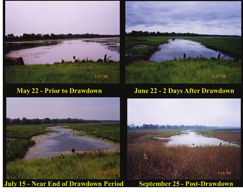
The US Army Engineer Research and Development Center (ERDC) solves the
nation’s toughest engineering and environmental challenges. ERDC develops innovative
solutions in civil and military engineering, geospatial sciences, water resources, and
environmental sciences for the Army, the Department of Defense, civilian agencies, and
our nation’s public good. Find out more at www.erdc.usace.army.mil.

To search for other technical reports published by ERDC, visit the ERDC online library
at https://erdclibrary.on.worldcat.org/discovery.
Engineering With Nature®                                                                 ERDC/EL SR-21-8
                                                                                          September 2021

Water Level Management for Enhanced Fish and
Wildlife Habitat Production in Upper Mississippi
River Navigation Pools
An Engineering with Nature® Review of Practice

Charles Theiling, PhD                                     Jon Hendrickson
US Army Engineer Research and Development                 US Army Engineer Corps of Engineers
Center                                                    St. Paul District
Environmental Laboratory                                  180 Fifth Street East
3909 Halls Ferry Road                                     St. Paul, MN 55025-1638
Vicksburg, MS 39180-6199
                                                          Kevin Kenow
Benjamin McGuire
                                                          US Geological Survey
US Army Engineer Corps of Engineers                       Upper Midwest Environmental Sciences Ctr
St. Louis District                                        2630 Fanta Reed Road
1222 Spruce Street                                        La Crosse, WI 54603
St. Louis, MO 63103
                                                          Kevin Landwehr
Gretchen Benjamin
                                                          US Army Engineer Corps of Engineers
The Nature Conservancy                                    Rock Island District
Great Rivers Partnership                                  PO Box 2004
La Crosse, WI 54601                                       Rock Island, IL 61204

Dave Busse                                                Tim Schlagenhaft
US Army Engineer Corps of Engineers                       Audubon (retired)
St. Louis District                                        Lake City, MN 55066
1222 Spruce Street
St. Louis, MO 63103                                       Mary Stefanski
                                                          US Fish and Wildlife Service
                                                          51 East 4th Street #100
                                                          Winona, MN 55987

Final report
Approved for public release; distribution is unlimited.

Prepared for   Dredging Operations Technical Support Program (DOTS)
               US Army Engineer Research and Development Center
               3909 Halls Ferry Road
               Vicksburg, MS 39180-6199
      Under    Funding Account Code U4359734; AMSCO Code 086000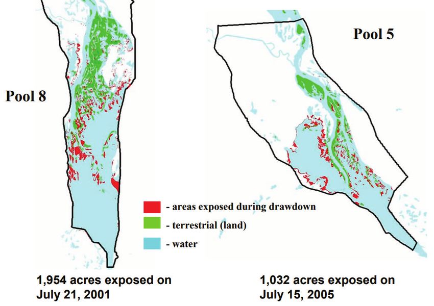
ERDC/EL SR-21-8                                                                                                               ii

Abstract
        There is a long history of fish and wildlife management associated with
        Upper Mississippi River navigation dams owned and operated by the US
        Army Corps of Engineers (USACE). Many operational changes have been
        made to improve aquatic habitat, with recent emphasis on pool-scale
        drawdowns to enhance wetland benefits without affecting navigation or
        other uses. This special report describes projects successfully
        incorporating Engineering With Nature® principles in a review of the
        physical setting and historical fish and wildlife habitat management efforts
        using Upper Mississippi River System navigation dams. We reviewed 80
        years of adaptation and lessons learned about how to integrate navigation
        operations and wildlife management. Several experiments have revealed
        the capacity to produce thousands of hectares of emergent and submersed
        aquatic plants, restoring much-needed riparian habitat for a variety of
        aquatic, wetland, and avian species.

 DISCLAIMER: The contents of this report are not to be used for advertising, publication, or promotional purposes.
 Citation of trade names does not constitute an official endorsement or approval of the use of such commercial products.
 All product names and trademarks cited are the property of their respective owners. The findings of this report are not to
 be construed as an official Department of the Army position unless so designated by other authorized documents.

 DESTROY THIS REPORT WHEN NO LONGER NEEDED. DO NOT RETURN IT TO THE ORIGINATOR.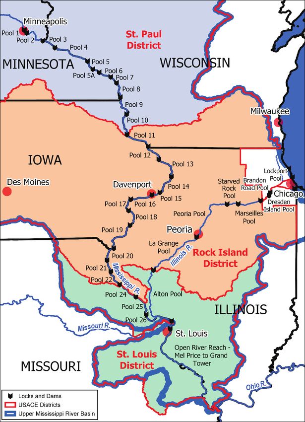
ERDC/EL SR-21-8                                                                                                                                                          iii

Contents
      Abstract..................................................................................................................................................... ii

      Figures and Tables .................................................................................................................................. iv

      Preface...................................................................................................................................................... v

      1      Introduction ...................................................................................................................................... 1
             1.1 Background ..................................................................................................................... 1
             1.2 Objectives ........................................................................................................................ 6
             1.3 Approach ......................................................................................................................... 7

      2      Water Level Management (WLM) Experiments ............................................................................. 8
             2.1      St. Louis District .............................................................................................................. 8
              2.1.1        Initial experiments .................................................................................................................... 8
              2.1.2        Recent environmental pool management (EPM) opportunities .......................................... 10
             2.2 St. Paul District ............................................................................................................. 13
              2.2.1        Small-scale (backwater lake) drawdowns............................................................................. 13
              2.2.2        Pool 8 drawdown .................................................................................................................... 14
              2.2.3        Pool 5 drawdown .................................................................................................................... 15
              2.2.4        Pool 6 drawdown .................................................................................................................... 16
              2.2.5        Advanced dredging ................................................................................................................ 16
              2.2.6        Coordination and monitoring ................................................................................................. 16
             2.3 Rock Island District ....................................................................................................... 17

      3      Planning and Policy Considerations ............................................................................................. 20

      4      Discussion ...................................................................................................................................... 23

      5      Conclusions.................................................................................................................................... 25

      References............................................................................................................................................. 27

      Acronyms and Abbreviations ................................................................................................................ 30

      Report Documentation Page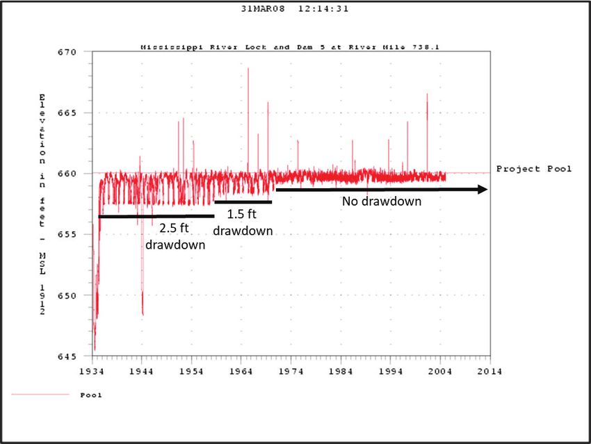
ERDC/EL SR-21-8                                                                                                                                                        iv

Figures and Tables
      Figures
      Figure 1. Upper Mississippi River (UMR) Navigation System in St. Paul, Rock Island, and
               St. Louis US Army Corps of Engineer districts. ......................................................................... 3
      Figure 2. UMR Lock and Dam 5 pool stage illustrates changes in operational drawdowns
               over time. ..................................................................................................................................... 4
      Figure 3. Areas vegetated during drawdowns on UMR Pools 24, 25, and 26 and Pool 22,
               which is not drawn down (black shaded areas represent new vegetation
               colonization due to the drawdown (Source: Wlosinski et al. 2000, 12). ............................... 9
      Figure 4. Vegetation growth on exposed mudflats caused by a 1–5 ft drawdown from
               March to June 2016 in Pool 24, UMR. The person is moving along an elevation
               gradient to illustrate the vegetation height difference achieved on substrate
               exposed for longer periods of time. The shortest vegetation occurs where deeper
               substrates were exposed, flooded, and exposed again in response to changes in
               river flow (top panels). The tallest vegetation occurs on areas
ERDC/EL SR-21-8                                                                 v

Preface
      This review of practice was conducted for the US Army Engineer Research
      and Development Center (ERDC) Engineering With Nature® (EWN)
      initiative (www.engineeringwithnature.org). Dr. Todd Bridges was the
      Program Manager of the Dredging Operations and Environmental
      Research (DOER) Program and EWN National Lead. This report was
      funded by the Dredging Operations Technical Support (DOTS) program
      under Funding Account Code U4359734; AMSCO Code 086000. Dr.
      Burton Suedel was the Program Manager.

      This review was completed by the Ecological Resources Branch (ERB) of
      the Ecosystem Evaluation and Engineering Division (EEE) of the ERDC–
      Environmental Laboratory (ERDC-EL). At the time of publication
      Dr. Lynn Escalon was Acting Branch Chief, ERB, Mr. Mark Farr was Chief,
      EEE. The Deputy Director of ERDC-EL was Dr. Brandon Lafferty, and the
      Director was Dr. Edmond J. Russo.

      COL Teresa A. Schlosser was Commander of ERDC, and Dr. David W.
      Pittman was the Director of ERDC.
ERDC/EL SR-21-8 1
1 Introduction
1.1 Background
Upper Mississippi River System (UMRS) navigation dams and locks (Figure
1) were approved in the 1927 River and Harbors Act 1, designed soon after,
and constructed during the 1930s. They follow a similar design, but each
structure is unique, with individual operating rules (WEST 2000; Wlosinski
and Hill 1995). The locks and dams maintain water depths suitable for
navigation during low-flow periods by maintaining a minimum water
surface elevation through gate adjustments. Nearly all dams periodically
operate in an open-river condition by lifting gates out of the water or
lowering them to the bottom, as is the case on several Illinois River dams,
during high river flows. At moderate river flows water levels at the dams
may drop in response to gate openings, a condition called “drawdown”. The
frequency of open-river conditions differs at each dam, which changes the
amount of time that water-level drawdowns can be performed through gate
operation. Recreational boating, municipal and industrial infrastructure,
and the design of lock chambers limit the amount of drawdown possible
during low-flow conditions. The window of opportunity to incorporate
drawdowns occurs between low-flow conditions and high flow, open-river
conditions.
Following construction through the 1950s, gates on most Mississippi River
dams were lifted to let ice pass during winter. Lentic fish that flourished in
the expanded impoundments became trapped when the pool levels were
dropped, so fisheries managers stepped in to protect the valuable fishery.
There was a period of “fish rescues,” when huge seines would be used to
corral fish in isolated pools. These fish would be transported to suitable
habitat or contributed to fish-stocking programs around the country.
Natural resource managers in the five UMRS states (Illinois, Iowa,
Minnesota, Missouri, and Wisconsin) formed the Upper Mississippi River
Conservation Committee (UMRCC) in 1943 to advocate for fisheries and
aquatic habitat, and they have been instrumental in the management of
the river. River teams formed in each Upper Mississippi River US Army
Corps of Engineers (USACE) district (that is, St. Paul, Rock Island, and
1. Act of January 21, 1927, Pub. L. No. 69-560, 44 Stat. 1010 (1927). https://www.loc.gov
/law/help/statutes-at-large/69th-congress/session-2/c69s2ch47.pdf.ERDC/EL SR-21-8 2
St. Louis Districts) to coordinate natural resource management,
advocating for reduced drawdowns in the 1960s and no drawdowns since
1972. Figure 2 demonstrates historical changes in minimum pool stage
regulations these groups were able to effect for Lock and Dam 5
operations.ERDC/EL SR-21-8 3
Figure 1. Upper Mississippi River (UMR) Navigation System in St. Paul, Rock Island, and St.
Louis US Army Corps of Engineer districts.
In addition to fish entrapment concerns, sedimentation and “pool aging”
(Lubinski 1999, 16–8) effects on aquatic habitat emerged as important
issues in the 1970s. Fisheries managers emphasized loss of depth inERDC/EL SR-21-8 4
backwater lakes where game fish overwintered. They requested in a 1996
Problem Appraisal Report that USACE manage winter water levels on the
high side of the operating band to maximize water depth in backwater
lakes. USACE also investigated policy and operational constraints on
increasing water levels.
Figure 2. UMR Lock and Dam 5 pool stage illustrates changes in operational drawdowns over
time.
UMRS water level management (WLM) prior to 1994 consisted of
maintaining overwintering fish habitat in connected backwaters and water
management in isolated wetlands for moist soil plant food resources for
migratory waterfowl. There were single-species management conflicts
(that is, fish versus waterfowl) regarding backwater lake management and
connectivity (UMRCC 2009) on the lower pools and Illinois River until the
UMRCC encouraged a broader view of ecosystem management as defined
by Grumbine (1984) during water management planning workshops held
in 1994.
The USACE Upper Mississippi River Restoration Program (UMRS) Long
Term Resource Monitoring Program (LTRMP) began investigating dam
operating procedures and practices in the early 1990s as some of its initialERDC/EL SR-21-8 5
ecological status and trends investigations (Wlosinski and Hill 1995).
Following UMRCC ecosystem management workshops in 1994, increased
appreciation for drawdown potential and plans translated to the launch of
an experimental phase of WLM in the three UMRS USACE districts,
discussed in detail below. Pool-scale WLM to mimic natural growing
season conditions (that is, reduced water levels to expose river edge and
mudflats to reinvigorate the seedbank) was first accomplished by the St.
Louis District as “environmental pool management” (EPM) (that is,
operating water levels for environmental benefits within authorized
operating limits) and in Rock Island and St. Paul Districts as pool-scale
drawdowns (that is, lowering water levels below authorized operating
limits). Pool-scale experimentation provided evidence necessary for
larger-scale program integration of water level management in the
Navigation and Ecosystem Sustainability Program (NESP). The Upper
Mississippi River–Illinois Waterway (UMR-IWW) System Navigation
Feasibility Study (USACE 2004) studied the potential costs for advanced
dredging and environmental benefits of WLM in nine navigation pools
with the highest potential for successful drawdowns (Table 1; Landwehr et
al. 2004). The NESP authorized funding for advanced dredging required
to support drawdowns and many other restoration projects. It became
apparent during experimentation and planning that in addition to
substantial environmental benefits, significant implementation costs,
human impacts, and potential negative effects on nontarget organisms like
freshwater mussels can also occur.
Although these studies were implemented before Engineering With
Nature® (EWN) was established, planners considered the economic,
social, and environmental benefits collectively prior to making WLM
recommendations. Current WLM embraces EWN principles, including
using science and engineering to produce operational
efficiencies; using natural processes to maximize benefit;
increasing the value provided by projects to include
social, environmental, and economic benefits; [and]
using collaborative processes to organize, engage, and
focus interests, stakeholders, and partners. (USACE
2018, 5)ERDC/EL SR-21-8 6
Table 1. Summary of costs and benefits (acres exposed for wetland establishment)
associated with navigation pool environmental drawdowns in St. Paul and Rock Island
Districts (1 ha = 2.47 ac). 1 (Source: USACE 2004).
Drawdown Dredging
magnitude Success Acres required Dredging Cost per
Pool (feet) rate (%) exposed (yd3) cost acre
1 95 1,200 135,811 $643,175 $585
5
2 81 2,200 287,236 $1,365,093 $620
1 98 1,206 0 $0 $0
7
2 74 2,331 215,000 $1,280,000 $549
1 74 1,300 2,000 $88,000 $68
8
2 50 3,090 120,253 $475,000 $154
1 71 4,571 0 $0 $0
9
2 57 6,932 75,000 $375,000 $54
1 91 399 0 $0 $0
11
2 86 883 49,368 $399,400 $452
1 86 1,560 35,200 $316,800 $203
13
2 86 2,822 131,032 $1,021,093 $362
1 55 157 13,200 $118,800 $757
16
2 55 307 75,636 $601,121 $1,955
1 50 484 26,400 $237,600 $491
18
2 50 761 133,848 $816,230 $1,385
1 100 790 4,400 $39,600 $50
19
2 100 1,627 50,380 $363,900 $248
1.2 Objectives
There is a long history of fish and wildlife management associated with
Upper Mississippi River (UMR) navigation dams. Many operational
changes have been made to improve aquatic habitat, with recent emphasis
on pool-scale drawdowns to enhance wetland benefits without affecting
navigation or other uses. In this special report, we review the physical
setting and historical fish and wildlife habitat management efforts with
emphasis on recent drawdown experiments that have been successfully
implementing EWN principles.
1. For a full list of the spelled-out forms of the units of measure used in this document, please refer
to US Government Publishing Office Style Manual, 31st ed. (Washington, DC: US Government Publishing
Office, 2016), 248–52, https://www.govinfo.gov/content/pkg/GPO-STYLEMANUAL-2016/pdf/GPO-
STYLEMANUAL-2016.pdf. For a full list of the unit conversions used in this document, please refer to US
Government Publishing Office Style Manual, 31st ed. (Washington, DC: US Government Publishing
Office, 2016), 345–7, https://www.govinfo.gov/content/pkg/GPO-STYLEMANUAL-2016/pdf/GPO-
STYLEMANUAL-2016.pdf.ERDC/EL SR-21-8 7
1.3 Approach
We prepared this review of practice to disseminate innovations in USACE
project operations for environmental benefit using the EWN platform for
communicating sustainable design and operational approaches. The UMR is
an example of a region with many large USACE projects that affect multiple
aspects of watershed, river, and floodplain management. A Congressional
designation for the UMR system as a Nationally Significant waterway and
ecosystem is unique and implies the inherent connections in the complex
social-ecological system. The social-ecological connections going back to the
Clean Water Act 1 implementation through recent navigation, floodway, and
environmental restoration planning also helped expand natural resource
management coordination among agencies and programs through
increased communication.
Traditionally, environmental benefits were associated with USACE
ecosystem restoration projects, and environmental impacts were associated
with navigation and flood-risk management projects. EWN, however,
provides a platform to share beneficial practices that produce a broader
range of ecosystem goods and services (EGS) associated with economic,
social, and environmental benefits. Natural resource managers in three
USACE districts within the UMR have partnered with fish and wildlife
management agencies since the inception of the UMR-IWW navigation
system nearly 80 years ago to avoid and minimize environmental impacts.
The shared understanding that emerged from collaborative planning and
implementation of multiple navigation and environmental restoration
projects led to new understanding of UMR operational and policy
constraints that could be optimized to achieve multiple benefits. The
problems, lessons learned, and opportunities discussed herein apply not
only across the large UMR area of operation but to USACE impoundments
in other river systems.
1. Federal Water Pollution Control Act of 1948, 33 USC. § 1251 et seq. (2018). https://www
.govinfo.gov/content/pkg/USCODE-2018-title33/pdf/USCODE-2018-title33-chap26.pdf.ERDC/EL SR-21-8 8
2 Water Level Management (WLM)
Experiments
2.1 St. Louis District
2.1.1 Initial experiments
St. Louis District was the first to implement WLM experiments, which
evolved into the current EPM for Pool 24, 25, and 26. EPM is successful in
St. Louis District because the dam and water management design includes
drawdowns as routine operational events and accommodates frequent gate
manipulations as conditions change. Each Pool is drawn down 3.5–6.5 ft
(1 – 2 m) (Table 2) during moderate discharge and then filled again or
allowed to flood depending on discharge. These operational conditions
were adapted for environmental benefits in 1994 and have been in
operation ever since. Several studies have documented the environmental
benefits of these operations (Wlosinski et al. 2000; Garvey et al. 2003;
Flinn et al. 2005; Flinn et al. 2008), and the district managed public
perception by coordinating with the barge industry and marina owners
affected by WLM operations.
Table 2. Operation elevations (feet above sea level) at dams 24, 25, and 26.
Pool Maximum Maximum EPM elevations
regulated pool drawdown
Pool 24 449.0 445.5 448.0–448.5
Pool 25 434.0 429.7 432.0
Pool 26 419.0 412.5 417.0
Experimental drawdowns were conducted in Pool 24 and 25 from
mid-June through July during both in 1995 and 1996 (Wlosinski et al.
2000). Water levels were held 1–3 ft lower than maximum regulated pool
elevation and raised gradually to avoid rapid inundation that would kill
emergent aquatic plants. Emergent plant sampling confirmed seven
genera colonizing mud flats in 1995 and five in 1996, which included
valuable waterfowl foods like pigweed (Amaranthus spp.), chufa (Cyperus
spp.), wild millet (Echinochloa spp.), rice cutgrass (Leersia spp.), sprangle
top (Leptochloa spp.), smartweed (Polygonum spp.), and foxtail (Setaria
spp.). Plants germinated and grew to 7–10 in, which allowed them to
survive when water levels were slowly raised. Spatial assessments
indicated production of 880 ac of moist soil plants in Pool 25 and 225 ac inERDC/EL SR-21-8 9
Pool 24, compared to only 51 ac in Pool 22, which was not drawn down
(Figure 3). Minnow seining conducted by the Illinois Department of
Natural Resources indicated no significant change to fish communities
(Wlosinski et al. 2000).
Figure 3. Areas vegetated during drawdowns on UMR Pools 24, 25, and 26 and Pool 22,
which is not drawn down (black shaded areas represent new vegetation colonization due to
the drawdown (Source: Wlosinski et al. 2000, 12).
Macroinvertebrate and zooplankton response to EPM was investigated in
Pool 25 during 1999–2000 (Flinn et al. 2005) because they are regarded
as important food resources for both fish and waterfowl. Opportunities for
EPM varied with discharge; high discharge in June and July 2000
prevented a drawdown. Moist soil vegetation was abundant following the
drawdown in 1999, leaving remnant stubble in spring 2000; it was absent
because of flooding in 2000, and it was moderately abundant in 2001.
Macroinvertebrates sampled in 2000 and 2001 were most abundant in
areas with successful vegetation response. Oligochete abundance wasERDC/EL SR-21-8 10
higher among vegetated plots in comparison to non-vegetated plots, which
accounted for most change. Zooplankton were not abundant in any
samples.
Flinn et al (2008) investigated differences in substrate, organic matter,
macroinvertebrate abundance, and fish communities along a longitudinal
gradient in Pool 25 during 2001–2003. Hinge-point water management
results in midpool reaches that are more stable than other parts of the pool
that experience drawdowns and flooding. Benthic organic matter was
stable at midpool but variable in the lower pool depending on vegetation
response to drawdowns. Smaller, fast-reproducing species (for example,
Berosus sp.) were common in the variable lower pool, and larger, longer-
lived species (for example, Hexagenia sp.) occurred in the midpool reach.
Fish communities were dominated by cyprinids, with limnophilic species
in the lower pool and rheophilic species in midpool, which is consistent
with findings in Pool 26 (Theiling, Maher, and Sparks 1996).
2.1.2 Recent environmental pool management (EPM) opportunities
Prolonged high-flow conditions upstream of Pool 26 in 2014 necessitated
an 86-day drawdown near the lower portion of the operating band (USGS
2019, 25). This atypical condition produced a higher diversity of both
annual and perennial aquatic vegetation, such as broadleaf arrowhead
(Sagittaria latifolia) and American lotus (Nelumbo lutea) (McGuire 2016,
6-7). These unique conditions demonstrate the possibility of regenerating
a mix of annual and perennial aquatic vegetation through extended
drawdowns.
After 2014, St. Louis District implemented an experimental operating
procedure to extend the drawdown period from the typical 30–45 days to
90+ days for four consecutive years. As has been the case for the last 20+
years, this experimental procedure was still within the normal pool
operating band (see Table 2).
In 2016, St. Louis District used USACE Sustainable Rivers Program
funding to monitor the benefits of long-term drawdowns (McGuire 2016).
Moderate to high discharge supported a 1 ft drawdown of 224 days and a 2
ft drawdown over 110 days. Emergent aquatic plant community
colonization in the drawdown area included 27 species in Pool 24, 17 in
Pool 25, and 14 in Pool 26. Vegetation growth was robust in the early
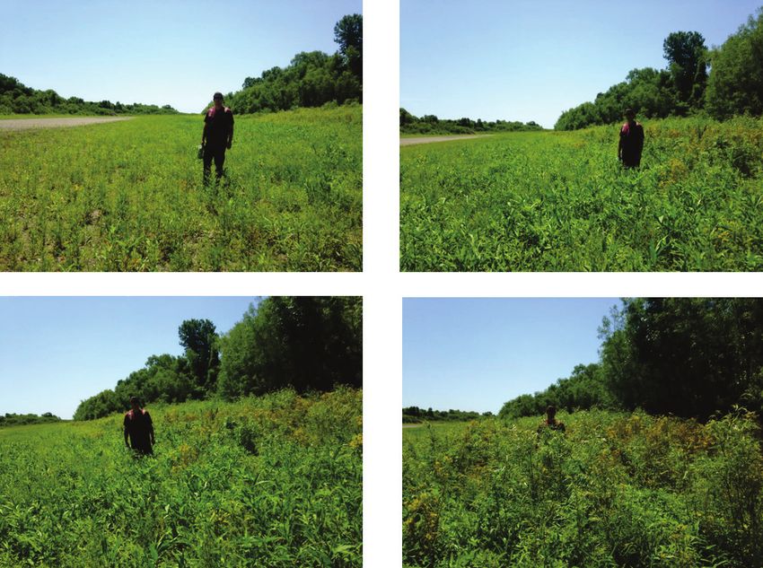
growing season (Figure 4) and continued through most of the growingERDC/EL SR-21-8 11
season to maturity. These benefits have been repeated in all but four of the
last 25 years (Table 3); thus, EPM operations represent an efficient
wetland management tool.
Figure 4. Vegetation growth on exposed mudflats caused by a 1–5 ft drawdown from March
to June 2016 in Pool 24, UMR. The person is moving along an elevation gradient to illustrate
the vegetation height difference achieved on substrate exposed for longer periods of time.
The shortest vegetation occurs where deeper substrates were exposed, flooded, and exposed
again in response to changes in river flow (top panels). The tallest vegetation occurs on areasERDC/EL SR-21-8 12
Table 3. Upper Mississippi River System (UMRS) navigation pool water-level management
(WLM) implementation by year (shaded boxes). Pools 24, 25, and Mel Price achieve success
within routine pool operational ranges (EPM); others are deviations from routine operations.
Mel price
Pool 5 Pool 6 Pool 8 Pool 13 Pool 24 Pool 25 pool
1994 WLM WLM WLM
1995 WLM WLM WLM
1996 WLM WLM WLM
1997 WLM WLM WLM
1998 WLM WLM WLM WLM
1999 WLM WLM WLM
2000 WLM WLM WLM
2001 WLM WLM WLM WLM
2002 WLM WLM WLM WLM
2003 WLM WLM WLM
2004 WLM WLM WLM
2005 WLM WLM WLM WLM
2006 WLM WLM WLM WLM
2007 WLM WLM WLM
2008
2009 WLM WLM WLM
2010 WLM
2011 WLM WLM WLM
2012 WLM WLM WLM
2013 WLM
2014 WLM
2015 WLM WLM WLM
2016 WLM WLM WLM
2017 WLM WLM WLM
2018 WLM WLM WLM
St. Louis District identified WLM opportunities to improve environmental
outcomes within their authorized operating band (see Table 2) and
without additional dredging. They undertook a purposeful experimental
approach to minimize social and economic effects while monitoring and
documenting environmental benefits. Success with EPM was documented
at the outset in the 1990s and again more recently (McGuire 2016) as plant
diversity and abundance increased in response to hydrologic conditions,
creating more opportunities for longer, deeper drawdowns. EPM
implements EWN principles by using science and hydrologic engineering
to increase environmental sustainability within routine operations;ERDC/EL SR-21-8 13
considering natural hydrologic cycles (that is, natural processes) in
navigation system and ecosystem operations; by increasing social and
environmental benefits beyond routine operations; and collaborating with
partners to implement, monitor, and communicate outcomes.
2.2 St. Paul District
2.2.1 Small-scale (backwater lake) drawdowns
The Water Level Management Task Force (WLMTF), a technical advisory
group to St. Paul District, was formed in 1995 to help coordinate
drawdown experiments (Kenow et al. 2016). Their initial water-level
drawdown experiments included implementing small-scale drawdowns on
small, isolated backwater lakes in Pools 5 and 9 during 1996 through 1999
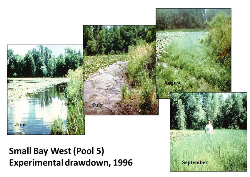
(Kenow et al. 2016; for example, Figure 5). Quantifying sediment and
plant response through monitoring supported further planning for pool-
scale drawdowns, which required significant interagency collaboration to
build broad support for the action. Public opinion and recreational
impacts were as important as potential navigation operation and safety.
Many complex policy questions raised by the WLMTF were satisfactorily
resolved by the small-scale drawdowns, so larger experiments were
implemented in Pool 8 during 2001–2002.ERDC/EL SR-21-8 14
Figure 5. Pool 5 experimental backwater drawdowns in 1996. The sequence of photographs
(left to right) through time from June to September 1996 shows the positive plant response to
the planned drawdown (USACE 2007, 2).
2.2.2 Pool 8 drawdown
St. Paul District also manages navigation pools using hinge-point control,
but the operating plans have smaller drawdowns of between 0.5 and 1 ft
and less flexibility in the range of water surface elevations that can be
maintained for a given flow condition (±0.2 ft). The configuration of St.
Paul District pools provides for large expanses of exposed substrate with a
1.5 ft drawdown, given appropriate river discharge. A pool-scale Pool 8
drawdown implemented from 2000 to 2001 was monitored by the
interagency WLMTF, and results were reported frequently in UMRCC,
river team meetings, and in the technical literature (Kenow et al. 2016).
The region contains abundant biodiversity, with approximately 50
different plant species observed on areas exposed during the drawdown
(Figure 6). During the second consecutive year of drawdown, the plant
community shifted from one dominated by annuals to one dominated by
perennials. Arrowhead (Sagittaria spp.) tuber production increased 16-
fold during the two years (Kenow et al. 2003, 53). There were noERDC/EL SR-21-8 15
documented fish kills, no negative effects on fish populations, and an
increase in forage species. However, freshwater mussels had higher than
anticipated mortality, which led to significant monitoring in subsequent
drawdowns (beyond regulated stages). Shorebird abundance doubled, and
waterfowl response was positive. Tundra swan response was exceptional,
but increased diving ducks were coincidental with other continental
factors. Other responses included sediment compaction and better water
quality (Nissen 2014, 70). The WLMTF did an outstanding job
communicating results to management agencies, affected businesses, and
the public to maintain support for the sustainable management action
(Kenow et al. 2016).
Figure 6. UMR Pool 8 and Pool 5 drawdown response (USACE 2007, 3).
2.2.3 Pool 5 drawdown
A pool-scale drawdown was implemented in Pool 5 during 2005 (Figure
6). This drawdown showed positive environmental responses similar to
Pool 8, but mussel mortality monitoring quantified negative impacts
(Nissen 2014, 50). Mussel survival in the drawdown zone was 72%,
compared to 100% in a control site. Survival was higher in deeper areas
and on slopes, and thick-shelled species survived better than thin-shelled
species. The impacts and desire to continue drawdowns prompted formal,ERDC/EL SR-21-8 16
pool-wide mussel population impact studies to document WLM benefits
for the UMR-IWW System Navigation Feasibility Study (Newton, Zigler,
and Gray 2015). Mussel population studies were conducted post hoc in
Pool 5 and in advance of Pool 6 and Pool 18 drawdowns to consider
impacts on endangered species.
2.2.4 Pool 6 drawdown
The Pool 6 drawdown in 2010 was implemented to further demonstrate
drawdown potential. It provided another opportunity to assess impacts to
freshwater mussels in a rigorous mussel distribution and mortality study
that tracked individual animals during 2009 (baseline) and 2010 (impact)
monitoring. Results detected 11% mortality in Pool 6 during the
drawdown, compared to 5% in a non-drawdown year. Mussel movement
increased in response to drawdowns, and their behavior was considered
consistent with each species biology. Thick-shelled mussels burrowed, and
thin-shelled mussels moved laterally with no apparent directionality of
movement toward water (Newton et al. 2015).
2.2.5 Advanced dredging
In both Pools 8 and 5, a significant amount of additional dredging was
required so that commercial navigation could continue during an
environmental drawdown. Pool 8 advanced dredging required 210,000
yd3, compared to a typical long-term average of 75,000 yd3. However,
following the increased dredging activity at the initiation of the drawdown,
Pool 8 required less dredging for two years after the drawdown. Routine
dredging returned the third year following the drawdown (Nissen 2014,
18). The cost of this additional dredging and identifying a funding source
are challenges that must be addressed before water-level drawdowns can
continue in St. Paul District.
2.2.6 Coordination and monitoring
St. Paul District anticipated challenges implementing drawdowns that
required deviations from traditional operation, so they implemented a
technical, policy, and social coordination process leading to pool-wide
drawdowns. They anticipated navigation impacts that required additional
dredging and reduced boat access to backwaters and marinas that required
public education. They did not anticipate impacts to nontarget species, but
these negative effects became an important concern after the first pool-ERDC/EL SR-21-8 17
scale experiment. Drawdowns were evaluated in two backwaters and three
pool-scale drawdowns over a decade.
WLM implements EWN principles in many ways, first by using
environmental science and hydrologic engineering to adapt navigation
system operations for enhanced environmental benefits. Regulating rules at
many UMR dams can be optimized to use natural flood cycles to support
managed drawdowns that promote emergent aquatic vegetation. WLM
practices increase environmental and social benefits beyond routine
operations for no or low costs relative to the substantial EGS benefits
derived. WLM requires substantial partnership and communication because
the approach affects thousands of shoreline acres for long river reaches.
Some WLM locations are rural. Some are highly populated, but all create
short-term impacts on public access and long-term benefits from improved
habitat and recreation opportunities. Extensive environmental monitoring
was conducted to quantify and communicate the impacts and benefits to
natural resource managers and the public. Implementing EWN principles
for WLM has created support to transfer the approach to other USACE
projects. The USACE Sustainable Rivers Program, which supports reservoir
adaptive management, has adopted WLM to make USACE lakes a greater
consideration in watershed management.
2.3 Rock Island District
Drawdowns in Rock Island District pools are typically not as feasible
within ordinary operating limits because most are operated at dam-point
control, which offers less flexibility; however, Pools 16 and 20 do have
hinge-point control (Landwehr et al. 2004).
Analyses completed by Rock Island District Hydrology and Hydraulics
Branch indicated a drawdown could be implemented for discharge
between 50,000 to 110,000 ft3/s in Pool 13, so there was reasonable
confidence it could be successful. An experimental drawdown of Pool 13
was implemented in 1998, with a goal for a 1 ft drawdown during the June
15 to August 15 period. Moderate discharge supported the drawdown only
through July 15, but photos document vegetation colonization on exposed
mudflats (Figure 7). The Pool 13 drawdown was not closely monitored and
gained negative public perception in the local area. Fisherman and bait
dealers complained about poor recreational access to Illinois Department
of Natural Resource staff, and biologists documented fish kills in isolated
lakes and wetlands. Illinois management agencies have not embraced theERDC/EL SR-21-8 18
practice in the region because of fewer opportunities and uncertain
success relative to existing conditions, but a new project is being proposed
to implement EWN principles on another Pool 13 drawdown experiment.
Drawdowns in Rock Island District have not been a management priority
since 1998, but there was substantial planning in 2006 for a Pool 18
drawdown under the Navigation and Ecosystem Sustainability Program.
The program was not funded, and the Pool 18 drawdown has not been
implemented. A full feasibility study evaluated alternatives, costs, and
benefits, with substantial emphasis on freshwater mussel impacts. There
was a positive recommendation for Pool 18 drawdowns but some concern
about the probability for success under changing hydrologic regimes.
Statistical analysis of USACE daily discharge records for a 30-year period
indicated a 30-day drawdown could be accomplished on average, once every
three years (Landwehr et al. 2004). Because of concerns that climate-
related hydrologic change would reduce drawdown success, for this report
we reviewed two-decade steps and found the probability for success
decreases through time (Table 4). Non-stationarity associated with climate-
related increases in river discharge can reduce the probability for drawdown
success in some reaches but increase it in others, like Pools 24, 25, and 26.
A system-wide re-evaluation of WLM opportunities is currently in progress.
Table 4. Probability for the correct moderate range of river discharge to support a 2 ft, pool-
scale drawdown in UMR Pool 18 for four 20-year time steps.
1940–1960 1960–1980 1980–2000 1990-2009
Years w/ Years w/ Years w/ Years w/
Drawdown drawdown drawdown drawdown drawdown
period opportunity (%)* opportunity (%)* opportunity (%)* opportunity (%)*
30-day 100 100 95 95
45-day 100 95 95 90
60-day 100 90 86 70
90-day 0 0 0 0
*Drawdown opportunity for the period July 10–September 30.ERDC/EL SR-21-8 19
Figure 7. Vegetation response to WLM in Pool 13, UMRS (Source: USACE–Rock Island
District).ERDC/EL SR-21-8 20
3 Planning and Policy Considerations
The WLMTF of the River Resources Forum (RRF) also conducted an
evaluation of WLM as a restoration tool (Nissen 2014). The WLMTF was
established in 1995 as a technical advisory group to the RRF, which
supports interagency coordination on river-related issues (Kenow et al.
2016). Representatives included four federal agencies and three state
departments of transportation and natural resources. Input was sought
from the public, nongovernmental organizations, and navigation and
recreation industries. The WLMTF provided an effective forum to address
issues related to WLM, and while participating organizations could vote,
the task force usually reached consensus on management decisions
(Kenow et al 2016).
In addition to the experimental drawdowns coordinated by the WLMTF we
describe above, the planning and policy review activities they undertook are
also noteworthy. WLM can prove contentious, with needs for navigation,
recreation, environment, and other social factors, so the WLMTF wanted to
remain inclusive and open. The group used significant partner engagement
to select sites, develop alternative plans, select a preferred alternative, apply
for waivers to change water control, and implement and monitor the
drawdown (Figure 7). A project report described the planning,
implementation, and monitoring results in great detail for the local
audience (Nissen 2014), and the science staff documented the ecological
response in the scientific literature (Kenow et al. 2016).
The UMR-IWW System Navigation Feasibility Study (USACE 2004)
included an environmental sustainability component that considered
system-wide opportunities for WLM (Landwehr et al. 2004). UMR river
natural resource coordination teams were consulted on a range of
considerations identified by the WLMTF. Each district team implemented
their review of WLM opportunities slightly differently than the others for
their river reaches, and results were compiled into system-wide
recommendations for WLM opportunities (Landwehr et al. 2004):
• growing season drawdowns—Pools 5, 7, 8, 9, 11, 13, 16, 18, 24, 25, and
26
• modifying dam operation from hinge-point to dam-point control—
Pools 16, 24, 25, and 26ERDC/EL SR-21-8 21
• modifying distribution of flow across dams—as needed for fish
passage–attracting flows;
• minimizing short-term fluctuations—Illinois Waterway.
The latest engagement on WLM was coordinated by the Upper Mississippi
River Basin Association (UMRBA), who held a workshop in April 2017 to
motivate progress towards implementing projects. Interagency
participation from all USACE UMR districts resulted in broadly supported
recommendations (UMRBA 2017):
1. Employ WLM opportunistically.
2. Perform a cost-benefit analysis to determine merit.
3. Address various policy and program implementation issues.
4. Implement drawdowns in Pools 13 and 18.
5. Seek and secure necessary funding.
6. Gain a better understanding of how hydrology and hydraulics affect river
management.
The UMRBA initiated a planning assistance to states agreement with St.
Paul District in 2018 to explore opportunities for more routine, systemic
WLM implementation. Progress toward WLM implementation continues
to be pursued in all parts of the river system.ERDC/EL SR-21-8 22
Figure 8. Process flow chart for planning and implementation of pool-scale drawdowns on the
UMR (adapted from Kenow et al. 2016, 301).
Input or activity Process
• Factors regulating pool water surface
elevation
• Extent of aquatic area benefit
• Dredging to support commercial and
recreational boating
• Hydrologic limitations Pool Selection
• Ability to conduct comprehensive
monitoring
• Socioeconomic factors
• Public input
• Develop alternatives: depth and duration
under regime flows
• Evaluate alternatives: consider hydrology
sediment transport, channel
Drawdown Plan
maintenance requirements, impact on Development
commercial and recreational facilities,
likelihood of ecologically effective
For Selected Pool
drawdown.
• Solicit public input
• Selection based on ecological need,
logistics of implementation, and public Plan Selection
acceptance
• USACE planning
document/environmental assessment Modify Reservoir
• Request to deviate from approved
reservoir plan Operating Plan
• Channel surveys and advanced dredging
• Recreational access dredging
• Monitoring by partner agencies: water Implement
quality, sediment, recreational use,
cultural resources, biological response Drawdown
• Public information campaignERDC/EL SR-21-8 23
4 Discussion
UMRS WLM was implemented years before the EWN approach was
formalized, but UMR planners and scientists implemented similar
principles very well and documented their experience for others to learn
from. Each UMR USACE district implemented drawdown experiments
differently because of their unique physical setting and agency-public
constituency, but they all used environmental science and hydrologic flow
frequency analysis to optimize water management strategies to achieve
increased wetland habitat benefits. The approach simulates low-flow
conditions of natural flood-drought cycles that promote a variety of
wetland functions. Operating procedures at some dams were adapted to
extend routine operational drawdowns for longer periods during the
growing season. Deviations from routine operations, advanced dredging to
maintain navigation, and significant coordination were required at other
sites. The drawdowns were implemented after considering the potential
social, economic, and environmental benefits, which were monitored to
document outcomes.
Social and economic impacts and benefits are closely related. The
commercial navigation system is the primary UMRS purpose, and it must
be maintained within authorized standards. Navigation has significant
positive economic cost benefits (USACE 2004), but other social effects and
environmental impacts of altered hydrology are evident and well
documented (USGS 1999). Pool-scale drawdowns were recommended in
1994 to counteract impoundment effects on riverine wetlands. The case
studies described here document that drawdowns can have positive
environmental benefits for no cost in some places. Cost for dredging to
maintain commercial navigation may be required in some places, but
drawdown costs were comparable to other ecosystem restoration measures
(USACE 2004). Drawdowns are cost effective because they influence large
areas and improve wetland habitat that benefits many species over
thousands of acres. The principle to use a science-based collaborative
process to organize and focus interests, stakeholders, and partners was an
important component of drawdown planning and implementation. The
UMR system wide WLM assessments (Landwehr et al. 2004) substantiated
the economic, social, and environmental benefits leading to an
authorization for widespread drawdown implementation (USACE 2004).ERDC/EL SR-21-8 24
Recreation can be temporarily affected by midsummer drawdowns that
limits access. The navigation channel depth is always maintained, but
backwater lakes, side channels, and marinas may become inaccessible
because of water-level reductions. Environmental planners were proactive,
seeking sponsors to support recreational access dredging to maintain Pool
8 marina operations. Recreational users, like fishers and hunters, were
educated through communication and outreach and ultimately came to
appreciate that temporary impacts on access would help restore and
maintain healthy ecosystems over longer periods of time.
Risk to freshwater mussels was the highest concern of implementing
drawdowns after unexpected strandings during early UMR pool-wide
drawdown experiments. Monitoring methods were developed and
implemented to document the potential impacts in subsequent drawdown
planning. Such impacts are not a factor for EPM, which occurs within
routine operating bands where mussel abundance is low. Many aquatic
and riparian species must be considered when planning WLM for
enhancing wetland benefits.
Impacts from hydrologic alteration are common in USACE water resource
projects, but as demonstrated herein, some impacts can be overcome or
minimized. As noted in the case studies above, experienced planning
teams can facilitate WLM decision-making with available data and tools to
view operational constraints on a project-specific basis. Experience from
UMR WLM can be applied in other regions with an EWN planning
approach that ensures coordination and communication to facilitate
technology transfer.ERDC/EL SR-21-8 25
5 Conclusions
Our review demonstrates that UMR WLM operations produce multiple
environmental, social, and economic benefits consistent with EWN
principles. We analyzed over 80 years of water management operational
practices, with an emphasis on the intentional alteration of USACE water
project operations to achieve multiple-use benefits. The UMR region has a
long history of developing large, integrated, water infrastructure plans
within institutional stovepipes that were traditional barriers to
information dissemination. However, recognizing the inherent physical,
hydraulic, and ecological interdependencies of UMR social, economic, and
environmental systems through ecosystem management planning in 1994
drove increased emphasis on collaborative planning on the UMR. WLM
was an outcome in which environmental scientists and river engineers
collaborated on navigation and ecosystem restoration mission integration
for increased UMRS benefits.
After reviewing experiences with WLM in three distinctly different regions
of the UMRS, we determined that there is a high level of success and
significant stakeholder support for the practice. Some of the challenges
ahead for expanding these practices on the UMR and elsewhere include
cost (for example, planning, increased annual dredging, monitoring); risk
to nontarget species (for example, mussels); risk to other river uses (for
example, recreation); desire from managers; and authority to deviate from
conventional water management protocols.
The challenges for WLM implementation can be overcome, because it can
often be implemented with little cost where no dredging is required. There
are engineering constraints on all projects, but the practice is widely
transferable to reservoirs, where slight changes to water management can
create significant wetland benefits. When compared to the cost of other
restoration projects, WLM with advanced dredging can be cost effective
because it affects large areas and has moderate cost per are. Risk to
nontarget species is not an issue where routine operations include
drawdowns; rather, it is an issue when lowering water levels below typical
stages. The risk can be minimized with slow changes in water levels and
rescue operations. Risk to other users must be considered, but primary
project purposes, like navigation or flood-risk management, must be
maintained during WLM implementation. Other uses like recreation or
habitat management might be interrupted, so there must be adequateERDC/EL SR-21-8 26
communication to help users adapt to temporary changes. Communication
and education about EWN approaches typically garners strong support for
the potential beneficial outcomes. Support from river users and
stakeholders can drive more interest in EWN approaches that might
motivate other river managers to ask for deviations from routine
operations. Evidence of successful WLM and sound engineering analysis
for new projects will provide information to support alternative water
management requests.ERDC/EL SR-21-8 27
References
Flinn, M. B., M. R. Whiles, S. R. Adams, and J. E. Garvey. 2005. “Macroinvertebrate and
zooplankton response to emergent plant production in upper Mississippi River
floodplain wetlands.” Archive for Hydrobiology 162:187-210
Flinn, M. B., S. R. Adams, M. R. Whiles, and J. E. Garvey. 2008. “Biological response to
contrasting hydrology in backwaters of upper Mississippi River Pool 25.”
Environmental Management 41:468-486.
Garvey, J. E, B. D. Dugger, M. R. Whiles, S. R. Adams, M. B. Flinn, B. M. Burr, and R. J.
Sheehan. 2003. Responses of fished, waterbirds, invertebrates, vegetation, and
water quality to environmental pool management: Mississippi River Pool 25.
Fisheries and Illinois Aquaculture Center, Southern Illinois University,
Carbondale, Illinois contract report to US Army Corps of Engineers, St. Louis
District.
Grumbine, R. E. 1984. “What is ecosystem management?” Conservation Biology 8:27-38.
Kenow, K. P., G. L. Benjamin, T. Schlagenhaft, R. A. Nissen, M Stefanski, G. J. Wege, S. A.
Jutila, and T. J. Newton. 2016. “Process, Policy, and Implementation of pool-
wide drawdowns on the upper Mississippi River: A promising approach for
ecological restoration of large impounded rivers.” River Research and
Applications 32:295-308.
Kenow, K. P., J. E. Lyon, R. K. Hines, and L. R. Robinson. 2003. Vegetation response to
a demonstration drawdown on Pool 8 of the Upper Mississippi River. P. 53 in
Proceedings of the 34th Annual Meeting of the Mississippi River Research
Consortium, 24-25 April, 2003, LaCrosse, WI. http://m-r-r-
c.org/Proceedings/2003_MRRC_proceedings.pdf.
Landwehr, K. J., C. H. Theiling, T. R. Gambucci, D. R. Busse, J. M. Stemler, and D. B.
Wilcox. 2004. Water level management opportunities for ecosystem restoration
on the upper Mississippi River and Illinois Waterway. Upper Mississippi River –
Illinois Waterway Navigation Feasibility Study Environmental Report 53. Report
prepared for the US Army Corps of Engineers.
http://www2.mvr.usace.army.mil/UMRS/NESP/Documents/ENVReport53.pdf
Lubinski, K. S. 1999. “Floodplain River Ecology and the Concept of River Ecological
Health.” In Ecological Status and Trends of the Upper Mississippi River System
1998: A Report of the Long-Term Resource Monitoring Program. Report
Number LTRMP 99-T001., La Crosse, Wisconsin: United States Geological
Survey.
McGuire, B. 2016. Environmental pool management 2016 summary report. US Army
Corps of Engineers, St. Louis District, St. Louis, Missouri.
Newton, T. J., S. J. Zigler, and B. R. Gray. 2015. “Mortality, movement, and behavior of
native mussels during a planned water-level drawdown in the Upper Mississippi
River.” Freshwater Biology 60:1–15.ERDC/EL SR-21-8 28
Nissen, R. A., editor 2014. Habitat enhancement using water level management on the
Upper Mississippi River. Water Level Management Task Force-River Resources
Forum, 87.
Theiling, C. H., R. J. Maher, and R. E. Sparks. 1996. “Effects of variable annual hydrology
on a river regulated for navigation: Pool 26, Upper Mississippi River System.”
Journal of Freshwater Ecology 11:101–114.
Upper Mississippi River Basin Association (UMRBA). 2017. Upper Mississippi River
Basin Association Water Level Management Workshop [proceedings]. Grand
River Center, 4-5 April 2017, Dubuque, IA. Upper Mississippi River Basin
Association, St. Paul, MN. 69 pp.
https://umrba.org/sites/default/files/documents/umrba-wlm-workshop4-
2017.pdf
USACE (United States Army Corps of Engineers). 2004. Final Integrated Feasibility
Report and Programmatic Environmental Impact Statement for the UMR-IWW
System Navigation Feasibility Study. US Army Corps of Engineers, Rock Island
district, Rock Island, IL. 705 pp.
USACE. 2007. Summary of Results of the Pool 5 and Pool 8 Drawdowns on the Upper
Mississippi River. River Resources Forum Water Level Management Task Force
Report.
https://www.mvp.usace.army.mil/Portals/57/docs/Navigation/River%20Resource%20Forum/S
ummary%20of%20Results%20-%20Pools%205%20&%208%20DDs.pdf
USACE. 2018. Engineering With Nature Strategic Plan 2018–2023:Expanding
Implementation. Vicksburg, MS: US Army Engineer Research and Development
Center. https://ewn.el.erdc.dren.mil/pub/EWN-StrategicPlan2018-2023FINAL.pdf.
USGS (United States Geological Survey). 1999. Ecological Status and Trends of the Upper
Mississippi River System 1998: a report of the Long Term Resource Monitoring
Program. US Geological Survey, Upper Midwest Environmental Sciences Center,
La Crosse, WI. LTRMP 99-T001. 236 pp.
USGS. 2019. Enhancing Restoration and Advancing the Knowledge of the Upper
Mississippi River. Science in Support of Restoration and Management FY19
SOW. Upper Mississippi River Restoration Program, US Geological Survey, La
Crosse, WI. 86 pp.
https://www.umesc.usgs.gov/ltrmp/documents/fy19_science_support1aug2019.pdf
UMRCC (Upper Mississippi River Conservation Committee). 2009. Habitat Connectivity
White Paper. UMRCC, US Fish and Wildlife Service, Marion, Illinois
https://docs.wixstatic.com/ugd/d70a05_f0de7e60309c43599986705b44ee1c6d.pdf
WEST Consultants, 2000. Upper Mississippi River and Illinois Waterway cumulative
effects study, Volume 1 and Volume 2. Environmental Report #40 for the Upper
Mississippi River – Illinois Waterway System Navigation Study. US Army Corps
of Engineers, Rock Island District, Rock Island, Illinois.
Wlosinski, J. H., and L. Hill. 1995. Analysis of water level management on the upper
Mississippi River (1980-1990). Regulated River Research and Management
11:239-248.ERDC/EL SR-21-8 29
Wlosinski J. H., J. T. Rogala, T. W. Owens, K. L. Dalrymple, D. Busse, C. N. Strauser, and
E. Atwood. 2000. Response of vegetation and fish during an experimental
drawdown in three pools, Upper Mississippi River. US Geological Survey, Upper
Midwest Environmental Sciences Center, La Crosse, Wisconsin, August 2000.
LTRMP 2000-T001. 18 pp. + Appendixes A – BYou can also read


