Where Is North? Directionality in Precolonial and Colonial Land Surveys in Korea, 1897-1918
←
→
Page content transcription
If your browser does not render page correctly, please read the page content below
Where Is North? Directionality in Precolonial and Colonial
   Land Surveys in Korea, 1897–1918

   Sora Kim

   Sungkyun Journal of East Asian Studies, Volume 21, Number 1, May 2021,
   pp. 105-122 (Article)

   Published by Duke University Press

        For additional information about this article
        https://muse.jhu.edu/article/797231

[ Access provided at 21 Aug 2021 05:54 GMT with no institutional affiliation ]
Where Is North? Directionality in Precolonial
and Colonial Land Surveys in Korea, 1897–1918
Sora Kim
Seoul National University
Abstract: We take the cardinal directions for granted, but they are social constructs. Directionality
is relative to how we locate central points, and these choices reflect a sense of direction in a society.
This article illustrates how the notion of “center” changed in Korean society by comparing land reg
isters of the Korean Empire (1897–1910) and the Japanese colonial period (1910–45). The colonial
government prioritized mapping with scale, contours, and cardinal directions. As a result, the entire
country was mapped to conform to a procrustean order. By contrast, there had been no cadastral
map for centuries prior. Instead, the location of each parcel was described in textual information
with four cardinal points. The author argues that fundamental difference between the two notions
of “center” lay in the consciousness of the relationship between the human and the natural. The
difference was expressed through the contrast in their respective conformity and flexibility, stan
dardization and diversity.
Keywords: sense of direction, land registers, land survey, mapping, indigenous knowledge
Maps have taken many forms. More recently, paper maps have given way to the
convenience of maps on digital devices. Despite these changes, the use of cardinal
directions remains central to allmaps. They are especially useful for finding routes
to unfamiliar places. By determining the cardinal directions, one can ascertain
the exact path to a destination. This awareness then takes for granted the cardinal
directions as a fact of nature, directly observed through scientific measurement.
We should realize, however, that this bearing system is also a social construct.
There are, of course, commonsense definitions for each direction. One might
think of “east” as the direction of the sunrise, but this notion tells us what “east” is,
not where. The earth is spherical, and there are no starting or ending points. What
is east can also be treated as west. If we can communicate effectively with cardinal
directions, it is because a commonsense point of reference is already implied. Take,
for instance, how we understand the positions of north and south. Current carto
graphic conventions set north on top, which looks natural to us, but even only a
century ago, numerous maps, especially in Asia, used “south-up” conventions.1 In
other words, current conventions of directionality have been formed by conscious
effort and motivated by specific intentions.
Sungkyun Journal of East Asian Studies 21, no. 1 (May 2021)
© 2021 Sora Kim
DOI 10.1215/15982661-8873955
This is an open access article distributed under the terms of a Creative Commons license (CC BY-NC-ND 4.0). 105Sora Kim
The eighteenth and nineteenth centuries saw significant developments in
measurement practices, many of which were promoted by Western imperialism.
There were several attempts to develop a common standard for a new age in the
world. The French Academy of Sciences desired to create universal standards of
measure and, for instance, established the meter as one ten-millionth of the dis
tance from the North Pole to the equator “for allpeople, for alltime” (Alder 2002:
1). Many such new standards were eventually adopted universally. The Japanese
acceptance of the Western clock in the nineteenth century is a good example.
Since Western timekeeping was entirely different from existing Japanese practices,
Japanese users had to study its mechanisms and practice it repeatedly before it
could be fully implemented (Frumer 2014, 2018). In Siam, new cartographic meth
ods were adopted over twenty years in the late nineteenth century. Although Siam
had its own methods of mapping, they were not legible to European powers such
as France and England. In the end, however, Siam reluctantly adopted Western
cartography to negotiate its territorial claims with Western powers (Winichakul
1994). The time difference between the initial introduction and full implementa
tion is a kind of buffering.
The Japanese and Siamese cases show how difficult the adoption of unfa
miliar standards could be, even when the process was considered necessary. Both
endeavored to grasp new principles and practiced them repeatedly, but it took
a long time for their acceptance to be seen as natural. During this process, pre
vious customs were cast as relics of ignorance, and they ultimately disappeared
from everyday usage. Unlike Japan and Siam, which adopted new conventions
with their political autonomy intact, the radical transformation of Korea occurred
within a few years under Japanese colonialism, armed with the tools of the mod
ern West. The colonial government (1910–45) converted indigenous practices and
established new Japanese institutions. The decades-long buffering period during
which Meiji Japan could gradually adopt Western knowledge and practices was
not allowed in Korea. Instead, the colonial government-general rearranged Korea
into a unified order under a Western-influenced but ultimately Japanese standard.
The colonial government implemented the Western model immediately, without
a buffer period.
Like Siam, Korea too had its own indigenous cartographic methods and
senses of direction, which were distinct from Western ones. The colonial govern
ment, however, used new cartographic methods for creating a map that would
be the basis for land taxation. This map used latitude and longitude lines and
followed a national standard for scale, size, and the position of directions, allof
which were unusual to Koreans.2 This rapid transformation led to the effacement
of indigenous customs, including the sense of direction.
To recover indigenous senses of direction, scholars have proceeded along
three lines of inquiry. The first is through a history of technology, notably the use
of the compass in Korea. This approach introduces several types of compasses or
examines their principles of operation and their technical accuracy (Kim C. 2003;
Cho 2011). Another approach is to focus on geomancy (C. fengshui; K. p’ungsu 風
106Where Is North?
水). The judgment of cardinal points is the basis of geomancy. As it measures rel
ative placement of geographical and architectural features, setting the center for
measurement can alter the result. Where the compass should be put thus was
the most important issue in geomancy (Yi and Kim 1988; Cho 2006). The final
approach is to understand directionality through Confucianism. In Confucian
ritual principles, each cardinal point represented status levels within a hierarchi
cal structure. Usually, north was the highest position. Deciding how and where
“north” was situated was essential to Confucian ritual practices (Yu 2004; Han C.
2006; Chi 2013).
These studies have contributed to the understanding of precolonial concepts
of directionality but are limited to technical and theoretical explanations. Theo
ries of geomancy or Confucianism can provide insights into the understanding of
space, but indigenous practices and customs also greatly influenced people’s sense
of directionality in everyday life. In addition, each kind of inquiry concentrated
on only one sense of direction. The first kind emphasizes absolute directions; the
second and the third lines focus on relative directionality. In reality, of course, both
types of directionality, absolute and relative, coincided. Both ways of thinking
about direction were used in conjunction during the precolonial period. Instead of
these theoretical explanations, scholarly analysis should focus on how direction
ality operated in familiar, vernacular, and everyday contexts.
This article thus seeks to recover a common sense of direction in daily life.
It does so by tracing the routes of land surveying during the Korean Empire (Tae
han Cheguk 大韓帝國) period (1897–1910) and analyzing how directionality was
determined. It helps reveal how common people thought about the directions in
the period. Although land surveying was an official project, elderly local Koreans
were mobilized to offer advice regarding the measurement of their villages. In this
process, the spatial awareness of these commoner residents could be reflected in
the official registers. Moreover, it could also implicitly reflect the sense of direc
tion in late nineteenth-century Korea. Despite the last king of the Chosŏn dynasty
(1392–1896) proclaiming himself emperor in 1897, with the adoption of a new
national name and accompanying administrative reforms, considerable continuity
was expected. This is because the local population and their existing senses would
not have dramatically changed with this political shift.
Comparing Directionality in Two Land Registers
The Korean Empire conducted a national land survey from 1898 to 1904. This
ambitious survey was conducted allacross the country and was the first national
survey in 180 years, the last having been taken in 1720. In Chosŏn society, where
land and population were the major tax sources, identifying these two revenue
sources was an essential step in national fiscal operations. Surveying every piece of
land across the country, however, was a huge and expensive project. Even though
the government could expect to see an increase in land tax revenue, an inability
to cover the high costs of such an ambitious project had stymied land surveys for
nearly two centuries. But after proclaiming the Korean Empire, Emperor Kojong
107Sora Kim
Figure 1. Kwangmu Land Register. In the first row, surveying
routes are recorded as one of four directions, as such “toward
the south” (nambŏm 南犯). The second row contains information
on the neighboring parcels and uses four cardinal points
(clockwise from the top: south, west, north, and east).
高宗 (r. 1863–1907) ordered the countrywide Kwangmu Land Survey (kwangmu
yangjŏn 光武量田) in 1898.
The results of the survey are compiled in the Kwangmu Land Register
(kwangmu yangan 光武量案), named after the reign era of Emperor Kojong (fig. 1).
For each piece of land, the register indicates the land category, shape, area, owner,
tax quota, and location. All of this information was recorded exclusively as textual
descriptions. Even the location of each plot of land was described solely in terms
of four cardinal points: north, south, east, and west. The absence of cadastral maps
or stable address systems in Korea during the preceding centuries meant that there
were no visual tools for determining the location of a specific plot of land.
When the colonial government conducted its own national land survey (t’oji
chosa saŏp 土地調査事業) from 1910 to 1918, it prioritized the mapping of each vil
lage with contours and latitude and longitude lines, following a national standard
for scale and size. When the Japanese occupied the Korean peninsula, the colonial
government faced a serious problem: Japanese officials could not determine where
each parcel in the prior Korean land registers was located in reality. Thus, they
hurried to make national sketch maps (kwaseji kyŏnch’wido 課稅地見取圖) show
ing the distribution of allpieces of land as a preliminary step toward the colonial
land survey. Unlike in the precolonial era, the colonial government used cadastral
maps to define exact locations. Through this process emerged a new address sys
108Where Is North?
tem whereby each plot of land within a village was numbered, a system that has
persisted to this day.3 Though only about a decade separated the two land surveys,
their survey methods were quite different.
These differences raise the following question: how could Koreans of the
Korean Empire period ascertain the location of parcels with only the four cardinal
directions? Such a task seems impossible for us, who have come to depend on lat
itude and longitude lines (or GPS systems). However, several contemporary socie
ties do use cardinal points mainly as location information. For instance, the cities
of San José in Costa Rica and Managua in Nicaragua indicate household addresses
in terms of cardinal points (Gugerty and Brooks 2001: 252). It is therefore possible
for a group of people to communicate position with cardinal directions, which was
the case in precolonial Korea. This implies that they possessed a sense of direction
distinct from that of modern Korean society.
To understand a precolonial, indigenous sense of direction, this article
compares Kwangmu registers with colonial cadastral maps to recover the survey
ing routes of Kwangmu measurement. Surveyors measured each plot of land by
conducting field surveys. The surveyors then proceeded to the next plot of land,
recording how each plot was connected to the other using the four cardinal direc
tions. By reading this textual information according to the order of the entries in
the register, we are able to reconstruct the routes taken by the surveyors. As men
tioned earlier, the Kwangmu survey did not use or make maps to show its course.
Thus, this article overlaps information from two primary sources—Kwangmu reg
isters and colonial maps—to locate each parcel in precolonial registers on colonial
cadastral maps and to determine the routes taken by surveyors for the Kwangmu
survey. For linking both sources, I used the software Jigsawmap, which was devel
oped for this task.4
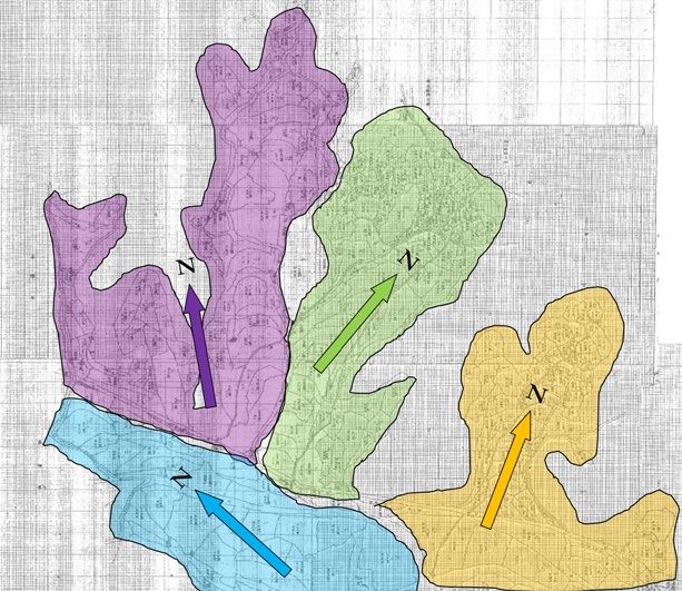
For this article I chose four villages in Hansan County (now Sŏch’ŏn) of
Ch’ungch’ŏng Province. The Kwangmu registers for this county were compiled in
July 1901,5 and the colonial land registers and cadastral maps were completed from
1913 to 1914,6 so there is roughly a twelve-year gap between the two land registers.
These four villages neighbor each other, as shown in figure 2, so surveying routes
can be drawn continuously even though the relative topographic characteristics
of each village are different. A range of hills divides village C (Mamyŏng-ni) from
village A (Kayang-ni) and village B (Yogok-ni). A stream flows from village A to B,
to C, and to D (Sinjang-ni). Village B has several valleys and is relatively higher in
terms of altitude. Village D, in contrast, is on a plain and was a marketplace dur
ing the Chosŏn dynasty. The Kwangmu survey proceeded in alphabetical order as
marked on figure 2.
After finding the location of each plot using the software, I drew a line on
the map along the course of the Kwangmu land surveys and examined the accu
racy of the surveying route information written in the register. For instance, if
the fifth plot is recorded as “toward the south,” it means that the plot is located
on the southern side of the fourth one. Thus, I checked whether the information
is correct or not on the cadastral map made just twelve years later by the colonial
government. The results were frustrating. Only about 80 percent of the direc
109Sora Kim
Figure 2. A map of the subject area.
tional descriptions were helpful for finding the location of the parcels. The other
20 percent are too vague to be of assistance in determining the exact location. For
example, there are several cases that record the location as “toward the south,” but
the actual location was on the northern side of the previous parcel of land. In this
case, the exact location of the next plots could not be verified based on the records
alone since there was no cadastral map in the Kwangmu era.
Combination of Egocentric and Environmental Directionalities
An ambiguity rate of 20 percent is a considerable obstacle to communicating
using the four-cardinal-direction system. Was this simply the result of human
error? According to the research of Leo Gugerty and Johnell Brooks (2001: 264),
“People on average make a navigational error on one of every three cardinal direc
tion judgments.” The study, however, also indicates that people who are trained
and have practiced finding cardinal directions, such as pilots, make fewer mis
takes. In other words, repeated practice can improve the ability to judge direction.
In the Chosŏn dynasty, Koreans, especially the male population, started learning
the cardinal directions and numbers at the age of six. This means that it is dif
ficult to imagine their sense of direction from a modern perspective. While we
are used to numerical designations, they were used to navigating with cardinal
points.
Thus, I retraced the process of my analysis and realized that an important
fact had been overlooked. Maps were not used for land surveys before the colo
nial period. Since there was no cadastral map in the Korean Empire period, it was
110Where Is North?
impossible to determine directions based on a map. Instead, the direction was
guided by descriptions using what Gugerty and Brooks (2001: 252–53) have called
the egocentric and environmental frames of reference:
The two most important reference frames used in navigation are the egocentric, or body-
referenced frame and the environmental, or world-referenced frame. The egocentric
frame represents navigational knowledge with respect to the navigator’s body using con
cepts such as up-down, front-back, and left-right. The environmental frame represents
navigational knowledge independent of the navigator’s perspective in the world using
concepts such as north-east-south-west, latitude-longitude, and compass coordinates.
This distinction between the body-referenced frame and the world-
referenced frame takes for granted the concept of cardinal directions. In indige
nous Korean senses of direction, however, directionality was understood in terms
of body-referenced notions in daily life. The Confucian ritual code that dominated
life in the Chosŏn dynasty emphasized social hierarchy and used the cardinal
directions as symbolic devices to express this order. The highest object or per
son was treated as “north,” even if it did not match the geophysical direction of
north. For instance, when the officials faced north in order to bow deeply toward
the Chosŏn king (pukhyang chaebae 北向再拜), they did not prostrate themselves
toward the geophysical northern side. Instead, they bowed toward Seoul, where
the North Star—the king—was located. Nevertheless, they regarded themselves as
facing north. In the same way, the king was always facing south, since he embod
ied the north.
Other directions were also set in turn by relative position: front is south,
left is east, right is west (Yu 2004: 6–11). This logic of relative directionality
applied to architectural layout as well. No matter the orientation of a building,
the same rules of front as south, left as east, and right as west applied. In this
scheme, north pointed to the direction behind the edifice (Chi 2013: 123). This
rule applied to many contexts. In Korea, for instance, the name of Namsan 南山,
which means literally “southern mountain,” is used for mountains in front of
the entrance of every village. Although this linkage between cardinal direction
(world-referenced) and egocentric (body-referenced) terms was at first theoreti
cal and symbolic,7 it soon melded into daily life and became what may be termed
a common sense of direction.
In other words, the indigenous sense of direction was shaped by a combina
tion of the egocentric and the environmental frames. Whereas modern Koreans
determine left or right in reference to their bodies, precolonial Koreans also veri
fied environmental directions, such as east or west, through an egocentric method.
The center of direction judgment was the individual, the ego.
I returned to the Kwangmu registers with an awareness of this principle of
directionality. Instead of determining direction by referencing the cadastral map, I
reconstructed the path the surveyors took as they conducted their measurements in
the field. Tracing the routes they walked and recording the direction of north at each
plot of land, the data in the Kwangmu registers began to take on a different form.
111Sora Kim
Figure 3. Directional information in
the Kwangmu land registers and actual
locations (*a = starting point).
During the initial examination, I fixed a north-south axis as a vertical line,
following the convention of cadastral maps in the colonial period. I checked the
accuracy of direction information in the Kwangmu land registers and discovered,
as mentioned earlier, that for about 20 percent of the cases the information was
unhelpful in determining the location of parcels. A section depicted in figure 3
is an example of this situation. Directions recorded in the registers do not accord
with the vertical north-south axis. Downward trajectories in the map were repre
sented as “toward the east” rather than “toward the south.” Such instances where
direction records do not correspond to the directional axes comprise the ambigu
ous 20 percent of cases.
Upon reexamination, we can adopt the vantage point of a person walking
on a three-dimensional terrain. Rather than visualizing moving down across
plots on a map, this walking motion can be envisioned as traveling ahead on flat
roads. Instead of traveling in a zigzag motion, as it would appear from the bird’s-
eye vantage of the map, the walker is turning at the corners of each plot. To judge
direction, such walkers must have a reference by which to set their directional axis
as they turn. In other words, a constant awareness of trajectory was needed. As
presented in figure 3, the walker identified a north-south axis that was offset from
true north by nearly 90 degrees. It is clear that the walker disregarded a sense of
true north, as indicated by the compass on the map.
With this in mind, we return to other examples in neighboring villages
and observe that each village can be divided into several blocks, according to the
112Where Is North?
Figure 4. Several blocks in village B. Each block shares the same direction
of north-south axis.
distinct north-south axes identified by the surveyors who walked through them.
Figure 4 is an example of this phenomenon in village B. The map is the north
western corner of village B. I drew four additional color-coded sections to mark
land registers with a shared definition of north as identified by the arrows of the
same color. Although there is no explicit borderline between each of the colored
sections, natural terrain features, such as streams, bogs, and hills, act as natural
boundaries between each section. Judging directions from an egocentric frame of
reference allows the north-south axis to be rearranged.
This reconstruction was possible since there were few main paths to walk
along in these small villages. Anyone who wanted to survey each block using the
shortest path would walk the same route. To reduce the time for land surveying,
investigators designed the entire course efficiently; they never traveled the same
route twice, doubled back, or crossed a previously traveled route. Local elders
were mobilized to guide them, and the names of these representatives for each
village are recorded in the Kwangmu registers. The local elders were senior res
idents of the village who knew the rural socioeconomic setting like the backs
of their hands. Most of the elders were in their forties to sixties. Some of them
had a good level of literacy in Literary Sinitic. But not allof them were elites.
According to a recent study, more than half of these local elders in a township
(myŏn 面) identified themselves as common farmers, not yangban elites (Kim K.
113Sora Kim
2018: 49–51). Official investigators, therefore, were guided by native senses of
direction that were shared within local society, senses that were documented in
these registers.
This situation tells us that local precolonial society did not fix a north-south
axis along a meridian line; instead, it allowed the rearranging of the axis according
to the lay of the land. This rearrangement, however, did not follow an arbitrary,
personal view. It reflected common senses of direction shared by residents within
each local community. In turn, these senses constituted the directionality of pre
colonial Korea. The senses were formed in the field, not on the map, which allowed
flexible arrangements according to environmental factors.
This directionality was ultimately displaced by a more rigid standard by the
Japanese colonial government under the name of modernization, which was in fact
a guise for Westernization. The colonial government established a standard for map
ping with a scale and a uniform axis, but these two-dimensional maps woven into
the grid left no space for a three-dimensional, on-the-ground sense of the land.
Cardinal Directions in Precolonial Society
The compass, a representative instrument for measuring bearing, was used pri
marily in geomantic works, for land surveys, and on voyages in precolonial Korea.
Until the Koryŏ dynasty (918–1392), compasses were mainly used by feng shui
experts. However, their accessibility improved, and by the fifteenth century they
were widely used by ordinary travelers. During the Chosŏn dynasty, a new kind of
compass called the yundo 輪圖 was introduced. There was also a portable type of
compass, the p’aech’ŏl 佩鐵, for which the male yangban class developed a special
preference, using it as an accessory. Chosŏn simplified the 360-degree system to a
twenty-four-point system. This twenty-four-point directional system was a more
differentiated one than the sixteen-point directional system that was typically
used in the West. And unlike Western compasses, Korean traditional compasses
took “south-up” shapes.
The ancients in the East Asian tradition believed that the four cardinal direc
tions were sacred and predicted people’s fortunes. It can be said that the religion
that believed in the worship of the gods of the four directions in the Koguryŏ king
dom (37 BCE–668 CE) belongs to this kind of belief. The sacredness of cardinal
points was also reflected in shamanism, which is well illustrated by the Korean
shamanic ritual kut. The performer sprinkles water in the four directions to create
order in the ritual space by following the hierarchical order of the cardinal points.
The symbolic meanings that had historically been used in relation to the cardinal
directions are arranged in table 1.
This symbolism reflected in the cardinal directions was applied in every
day life and affected decisions about sites for homes or graves. We need to think
about whether the relationship between the cardinal directions and the four
sides was a reciprocal one. In other words, when people perceived the east as the
left, they might in turn have considered the left as east. Of course, the four car
dinal directions existed first, and the symbolic system was created later. But if
this understanding was deeply embedded within society and used as a matter of
114Where Is North?
Table 1. The Cardinal Points and the Five Elements System
North South East West Center
Directions back front left right center
Five Elements water fire wood metal earth
Colors black red green white yellow
Heavenly Creatures tortoise bird dragon tiger qilin 麒麟 (mythical
hooved chimerical
creature)
Planets Mercury Mars Jupiter Venus Saturn
Seasons winter summer spring autumn long summer
Blood Circulation kidneys heart liver lungs spleen
Organs
Sensory Organs ears tongue eyes nose lips
Source: Chen (2009: 231)
course in everyday life, the symbols and cardinal directions would have naturally
evolved into a bilateral relationship. Therefore, I conjecture that, instead of using
a compass to determine the cardinal points, people might have determined the
directions within their symbolic system. In other words, the common sense of
directionality composed of these symbolic meanings accounts for the ambiguity
of 20 percent of the data in precolonial land registers.
The Matter of Scope
The Kwangmu Land Survey was one of the grand reform projects undertaken by
the government of the Korean Empire. This nationwide survey was carried out
in 218 counties. The court set only minimal regulations for this national project,
which had the effect of allowing for local and situational diversity.8 At the same
time, the project did not include mapping, because it could not portray three-
dimensional diversity on two-dimensional paper. The colonial government, by
contrast, saw mapping the entire country as a prerequisite to the national land
surveys (Yi 2013: 427–28). Cadastral maps were produced according to uniform
standards: north-up orientation, unified scale, and uniform size. Explicit border
lines were drawn between parcels, and every natural feature was captured on the
maps. The human was separated from the environment and became an observer
above the maps.
During the Chosŏn dynasty, numerous maps of diverse scope, ranging from
county-level maps to those covering the world, had been produced.9 A significant
characteristic of those maps is the diversity of directionality. After the sixteenth
century most Chosŏn world maps set north as the top, a result of the influence of
Westerners, such as Matteo Ricci, on Chinese cartographic conventions. Unlike
world maps, maps of individual counties were portrayed in a variety of ways. The
dynasty occasionally published official chronicles of allthe counties (ŭpchi 邑誌),
115Sora Kim
which included maps of each county. The court collected maps from local offices,
and each office had to draw up a map on its own. As a result, these maps did
not reflect a uniform style, even though they were compiled in the same book.
Directional orientation differed from one county to the next. The map could be
top-oriented to not just north but any direction, such as southwest. Interestingly,
any one county usually maintained the same directionality regardless of when the
maps were drawn. If a county had set east as the top, this position would continue
for at least several future maps, suggesting that a single locale shared a common
sense of direction. The agency of the locality persisted through the final compre
hensive compilation of allthe counties (Chibang chido 地方地圖, 1872).
A similar phenomenon can be observed in France. In the seventeenth cen
tury the French developed cartography for administrative purposes. Unlike mil
itary or academic ones, these new administrative maps were drawn simply, with
minimal markings. Chandra Mukerji (2007: 233–37) demonstrates that this dif
ference was the result of their distinct political purposes. Depending on their pur
pose, maps could be drawn as a form of “far-sightedness” or “near-sightedness.” As
such, the precision or consistency of cartographic conventions differed according
to a map’s purpose, especially its political aims. At the same time, however, dif
ferences of spatial consciousness, and of geographical scope in particular, are a
major factor as well. Even when a local map is drawn for the exclusive use of local
administration, if the mapmakers’ geographical imagination included the entire
country or the world, each local map would likely follow conventions that inte
grate representations of a locale within broader spatial representations. In other
words, an awareness of geographical scope can influence the degree of diversity in
cartographic conventions.
This matter of scope is related to the issue of north and south. In the case of
indigenous Korean maps, if only a small locale was the object of mapping, its top
orientation was not a major issue. The map needed only reflect the local senses of
direction. Broadening the map’s scope to encompass the world, however, compli
cates the story. Although there were several world maps in the Chosŏn dynasty,
the north and south poles were shown in maps only after the importation of Ricci’s
cartography in the sixteenth century. This expansion of geographic imagination,
however, exercised only a limited influence on Korean cartographic practice.
It was only with the colonial period that Korean geographic imagination truly
expanded to global parameters.10
A case study by Tad T. Brunyé et al. (2012: 1891) shows that participants
from diverse places of origin with varied natural terrain features nevertheless
alltended to associate “the north with mountains and south with level terrain.”
Moreover, people tend to recognize north as up and south as down, even when
there is no “explicit connection between north and up, or south and down.” This
research implies that exposure to maps, atlases, and GPS devices showing “north
in a physically upward orientation” might shape spatial awareness. In other words,
repeated learning of north-as-up has influenced senses of directionality to accept
conventional arrangements of north and south as natural.
116Where Is North?
One might suppose that restoring alternate senses of directionality is only a
matter of turning around a map. The switching of up and down, however, requires
a reversal of existing senses, which is no simple matter. The Japanese adoption
of the Western clock faced similar challenges. Although Western timekeeping
appears natural and practical to us now, it appeared too specialized and technical
to Japanese in the nineteenth century. One of the difficulties was the location of
the numeral 12. Unlike Western clocks, the “the twelve hours of the Japanese dial
were correlated to the twelve cardinal directions, commonly represented with the
north (associated with midnight) placed at the bottom” (Frumer 2014: 808). Thus,
to turn the clock upside down, the entire knowledge structure of temporality and
directionality in a society had to be transformed simultaneously. Likewise, turn
ing the map requires a fundamental switch of existing senses. In the same way,
current cartographic conventions result from continuous and conscious efforts to
convert diverse models into a uniform Western style.
The Question of Center
To ascertain the cardinal directions, one needs not only the four points but also
a fifth point—the center. In East Asia, these five points, north, south, east, west,
and center, were considered the five cardinal directions.11 Thus, any discussion of
bearing should also consider the role of the center. Setting the center was the basic
issue of geomancy, which observes the relative location of features to read the flow
of energy. Usually, geomancy measures immovable features such as mountains,
rivers, and buildings. The only movable factor is the compass: the center.
The fundamental question, then, was where the compass should be placed.
If the center moved, the four surrounding directions also moved with it. Since
geomancy treated the position of the compass as the center of a small cosmos,
the relative directionality of one feature could therefore change according to the
relative position of the compass (Cho 2006: 8). Unsurprisingly, there were several
different theories in China, Japan, and Korea about setting the compass, informed
by cultural and social factors (Yi and Kim 1988). With each theory reflecting views
of the world in each region and period, diversity in and of itself was valued (Cho
2006: 12–16).
The possibility of multiple centers was not just a matter of importance for
geomancy; it was also an important question in the history of Korea. There had
been two cosmological “centers” historically: Seoul, the capital of Korea, and
Beijing, the capital of China. People simultaneously regarded both of them as the
center for centuries. This pluralistic cosmological view, which accommodated
multiple centers, was not contradictory in indigenous frames of reference,12 and it
influenced cartographic conventions in precolonial Korea.13
Returning to the Kwangmu land surveys, the salient question is which point
was the center used for the surveys; it was neither Beijing nor Seoul. Instead of
choosing a center from among multiple candidates, surveyors followed the geo
mantic convention of a movable center. Official investigators and native dwellers
traveled together as a group to survey lands. The group stopped at each plot to take
117Sora Kim
measurements and identify neighboring plots. Each halt functioned as a reset
ting of the compass, and the surveying crew itself became the central directional
reference point, which made realigning the north-south axis possible. Since the
land registers were made for future users, not for the group itself, the group took
the perspective of future individuals who would walk the same path. In other
words, the Kwangmu survey assumed indigenous senses of direction, where the
vantage point of each individual was a movable compass and therefore the center
of a small, local cosmos.
This mobility of the center was ignored by modern cartography in the colo
nial period. Instead of using individual, human-centered vantage points as a refer
ence, directionality was settled by the legends on the map. These new conventions
emphasize their own objectivity in line with Western models while treating previ
ous senses of direction as subjective. The implementation of a new address system
altered the role of cardinal points, as taking the vantage point of someone on the
road or imagining the actual environment was no longer necessary; instead, one
only had to look at a map.
Conclusion
The human body is ruled by time and space. Humanity, in turn, has tried to mea
sure both more accurately through technology. Though electronic clocks and
GPS devices can show precise values, they also deprive our senses of the ability to
measure the environment from the vantage point of where we stand. Our sense of
direction grows increasingly impotent as we rely on GPS navigators or electronic
maps to determine location and track movement.
In this current situation, reviewing the premodern senses of direction gives
us some implications. Moderns like us who are accustomed to visual maps and
modern geographic education tend to consider the cardinal directions as natu
ral elements, but they should be understood instead as a kind of social contract.
Depending on the setting of a center or the given hierarchy among features, we
can arrive at different results when measuring the cardinal directions of the same
object. If we take this into account, our understanding of indigenous senses of
direction in precolonial Korea can be renewed; these senses can be characterized
as relativity, flexibility, and diversity.
First, before the twentieth century there were no cadastral maps in Korea
in which the shape of each piece of land was drawn. Instead, before the Korean
Empire, people recorded textual information to show the location of individ
ual parcels even in national land surveys. This information was too difficult to
be properly understood by third parties, including the colonial government,
who were also not locals. This was because the viewpoint on the actual site was
recorded in registers that could not be accessed within a compiled book. In other
words, textualized three-dimensional viewpoints could not be understood by
third parties who did not know the local environments. This indigenous perspec
tive can be explained as a combination of egocentric and environmental frames.
For those of us today who are accustomed to choosing one of these frames, it is
118Where Is North?
difficult to fully understand their records. This was the reason the government-
general hastened from the 1910s onward to make cadastral maps.
Second, to grasp the notion of directionality in Chosŏn society, it is necessary
to look back on their notion of the center. Diverse centers were set depending on
the type of work—world maps, local maps, land registers, and so forth—and the
surrounding environments were rearranged in correlation to the position of the
center. This is one of the reasons that Chosŏn’s maps are not cadastral maps but
paintings. The toleration of various centers is a characteristic of Chosŏn society.
Conversely, since the colonial period, Korean society has been devoted to
producing standardized maps that could be read and used at any time by anyone.
It was therefore unavoidable to establish solid standards and turn them into a new
social contract. In this process, the previous indigenous senses of direction and
centers were regarded as inaccurate and irregular and lost their meaning.
The key point, however, is not the existence of standards. Although Kore
ans set each person with his or her own compass, they shared a common sense of
direction. Continuous communication among themselves, with others, and with
the environment within the principle of cosmic resonance could convert subjec
tivity into diversity. We should recognize our position within the environment
instead of presuming to be a distant observer. As movable compasses, we should
ask ourselves, “Where is my north?”
Sora Kim is a researcher at the Kyujanggak Institute for Korean Studies. Her interests include
socioeconomic history of Chosŏn dynasty. Her article “For Whom the Line Is Drawn: Korean
Indigenous Conceptions of Boundary in the Nineteenth Century and Changes in the Colonial
Period” was published in Korea Journal in 2020.
NOTES
1. Other cardinal points have been placed on “top” as well. South was most preferred as
up in East Asia.
2. Of course, these had been discussed and used among a few elites in precolonial Korea.
The latitude of Seoul from the North Pole was measured in the fifteenth century, and several
maps from the eighteenth century use the latitude-longitude structure. However, they were not
employed as cartographic conventions. Most Korean maps are said to look like drawings, which
is because they did not follow strict measurement methods (Han Y. 1999: 30–102).
3. Korean society had used this land lot–based address as the official address system
since the colonial land survey. The Korean government changed the address system into the road
name address system in 2014. Most Koreans, however, are still confused and use both address
systems together.
4. Jigsawmap is a software program developed years ago through the collaboration of a
few Korean historians and computer engineers at Seoul National University. For more informa
tion, see hcil.snu.ac.kr/research/jigsawmap (last accessed April 25, 2020).
119Sora Kim
5. Ch’ungch’ŏngnam-do Hansan-gun Yangan 忠淸南道韓山郡量案 (The Kwangmu
Land Register of Hansan-gun, Ch’ungch’ŏngnam-do) was made by the Yangji Amun 量地衙門 (Min
istry of Land Survey). The registers are currently owned by the Kyujanggak Institute for Korean
Studies, with call number 奎 17671-16. For a detailed bibliography, see Kyujanggak Institute for
Korean Studies of Seoul National University 2013: 239–43.
6. The colonial registers are owned by the Sŏch’ŏn-gun County Office. Cadastral maps
can be browsed through the website of the National Archives of Korea (www.archives.go.kr).
7. This understanding of direction came from Chinese culture. For Chinese symbolic
meanings of cardinal directions, see Chen 2009.
8. The government did not fix the form of registers. Its final form was shaped and unified
only as the survey proceeded (Wang 1995: 66–70).
9. For a brief history of cartography in Korea until the nineteenth century, see Han Y.
1999. For world maps in the Chosŏn dynasty, see O 2011.
10. For instance, the term Nambang 南方, which literally means “southward,” became a
reference for Southeast Asia after the colonial period (Kang 2014).
11. Each point, including the center, had symbolic associations (Chen 2009). A different
color represented each of the cardinal directions. A few maps marked five areas with the five
representative colors (Han Y. 1999: 33–91).
12. For a representative treatment of this theme, see No 1999.
13. The most famous national map made in the nineteenth century sets Seoul as the
standard of measurements (Wŏn 1989: 53). Beijing acted as the center for world maps after the
eighteenth century (Pae 1999: 158).
REFERENCES
Primary Sources
Chibang chido 地方地圖 [The final comprehensive compilation of allthe counties in 1872].
Kyujanggak Institute for Korean Studies.
Ch’ungch’ŏngnam-do Hansan-gun Yangan 忠淸南道韓山郡量案 [Kwangmu land registers]. Kyu
janggak Institute for Korean Studies (call number 奎17672-16). T’ojidaejang 土地臺帳
[Colonial land registers] of Sŏch’ŏn-gun County. Sŏch’ŏn-gun County Office.
Secondary Sources
Alder, Ken. 2002. The Measure of All Things: The Seven-Year Odyssey and Hidden Error That
Transformed the World. New York: Free Press.
Brunyé, Tad T., Stephanie A. Gagnon, David Waller, Eric Hodgson, Sarah Tower-Richardi, and
Holly A. Taylor. 2012. “Up North and Down South: Implicit Associations between Topog
raphy and Cardinal Direction.” Quarterly Journal of Experimental Psychology 65: 1880–94.
Chen, Qun Rene. 2009. “Cardinal Directions in Chinese Language: Their Cultural, Social, and
Symbolic Meanings.” ETC: A Review of General Semantics 66, no. 2: 225–39.
Chi Hyŏnju 지현주. 2013. “Chujagarye e naejaedoen pangwigwan kwa chilsŏ ŭisik e kwanhan
yŏn’gu” 주자가례에 내재된 방위관과 질서의식에 관한 연구 [A study of the viewpoint of
direction and the ceremony of order in the Karye (Master Zhu’s family rituals)]. Tongyang
ch’ŏrhak yŏn’gu 74: 115–50.
120You can also read