Geologic setting and ecological functioning of coral reefs in American Samoa
←
→
Page content transcription
If your browser does not render page correctly, please read the page content below
Birkeland, C., P. Craig, D. Fenner, L. Smith, W. Kiene, B. Riegl. 2007. Geologic setting and ecological
functioning of coral reefs in American Samoa. Chap. 20. In: Riegl B., R. Dodge, (Eds). Coral reefs of the
USA. Springer Publishers.

16. Geologic setting and ecological functioning of
coral reefs in American Samoa
Charles Birkeland
Hawaii Cooperative Fishery Research Unit, USGS, University of Hawaii, Honolulu,
Hawaii 96822 USA (808) 956-8678, fax (808) 956-4238, charlesb@hawaii.edu

Peter Craig
 National Park of American Samoa, Pago Pago, American Samoa 96799 USA 011 (684) 633-
7082, 011 (684) 633-7082, fax 011 (684) 633-7085, peter_craig@nps.gov

Douglas Fenner
Department of Marine and Wildlife Resources, Government of American Samoa, PO Box 3730,
Pago Pago, AS 96799 USA 011 (684) 633 4456, fax 011 (684) (684) 633-5944
douglasfenner@yahoo.com
Lance Smith
 Department of Zoology, University of Hawaii, Honolulu, Hawaii 96822 USA
(808) 221-8276, fax (808) 956-4238, lancesmi@hawaii.edu

William E. Kiene
Fagatele Bay National Marine Sanctuary, PO Box 4318, Pago Pago, American Samoa 96799
USA 011 (684) 633-7354, fax 011 (684) 633-7355,William.Kiene@noaa.gov

Bernhard Riegl
National Coral Reef Institute, Nova Southeastern University Oceanographic Center, 8000 N.
Ocean Drive, Dania, FL 33004 USA (954) 262 3671, fax 954-262 3648, rieglb@nova.edu
16.1 Introduction
American Samoa has been a territory of the United States since the signing of the
17 April 1900 Deed of Cession. Although debated among historians, many
believe that the Samoan Islands were originally inhabited as early as 1000 BC.
Samoa was not reached by European explorers until the eighteenth century.

The division between American and independent Samoa is very recent and pre-
Western history of both Samoan groups is inextricably linked. The Manu’a
Islands (Ofu, Olosega, Ta’u) of American Samoa have one of the oldest histories
of Polynesia, and the Tuimanu’a title, formerly held by the highest chief of the
Manu’a islands, is considered the oldest chiefly title. The title’s name is obviously
derived from the islands’ name and its prestige is because the Manu’a Islands
were, at least according to Samoan oral tradition, the first islands settled in
Polynesia. During the Tongan occupation of Samoa, Manu'a was the only island
group that remained independent because of the familial relationship between the
Tuimanu'a and the Tuitonga, who was descended from a former Tuimanu'a. The
islands of Tutuila and Aunu'u were culturally connected to Upolu Island in what is
now independent Samoa. Still today, all the Samoan Islands are politically
connected through the chieftain system and through family connections.

Early Western contact did not get off to a good start because of a battle in the
eighteenth century between French explorers and islanders in Tutuila, which
earned the Samoans a fierce reputation.

In March 1889, a German naval force shelled a village in Samoa and also
destroyed some American property. An impending battle between three American
warships, ready to open fire on the three German ships, was made moot by an
intervening typhoon – which sank both the German and American fleets. After an
outbreak of tribal warfare led the British to loose interest in Samoa, Americans
and Germans divided the islands in the Treaty of Berlin in June 1899. Western
Samoa went to Germany, and eastern Samoa became American Samoa.

                                                                                   2
The US Navy quickly built a coaling station in Pago Pago harbor for its Pacific
Squadron and appointed a local Secretary. The Navy secured a Deed of Cession of
Tutuila in 1900 and a Deed of Cession of Manu’a in 1904. In 1914, New Zealand
occupied German Samoa, which then became British and, finally, independent in
January 1962.

Samoans were at times at odds with the colonial governments, which led to the
creation of the Mau movements (Mau meaning “opinion” or “testimony” in
Samoan), essentially non-violent resistance movements which were largely
suppressed. In 1940, the port of Pago Pago became a training and staging area for
the U.S. Marine Corps. During the war years, the United States built roads,
airstrips, docks and medical facilities exposing island residents to the American
way of life and causing some major damage to the coral reefs.

After the war, an attempt, primarily through the efforts of American Samoan
chiefs, to incorporate American Samoa, was defeated in Congress. This led to the
creation of a local legislature, the American Samoan Fono which meets in the
village of Fagatogo, the official capital of the territory. The Navy-appointed
governor was replaced by a locally elected one, and American Samoa is now self-
governing under a constitution of July 1967.

American Samoa is rich in coral reefs and all islands are more or less fringed by
coral reefs. Although structurally not part of the Samoan chain, political American
Samoa includes Rose Atoll, a true atoll, and Swains Island. The coral reefs of
American Samoa are integrated into a national protected areas system with the
National Park of American Samoa (US Department of Interior) managing some
coral reefs on the north coast of Tutuila near Vatia and along the shores of
southern Ofu, and southeastern Ta’u, while the National Marine Sanctuary
Program (US Department of Commerce) manages Fagatele Bay.

                                                                                 3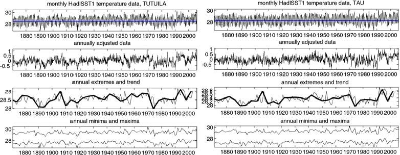
16.2 Geographic Setting
American Samoa is situated in the South Pacific ocean on the Pacific Plate, the
largest of the world’s tectonic plates. Like other archipelagoes on the Pacific Plate
(e.g., Hawaiian, Society, Marquesa, Tuamotu, and Caroline Islands), the Samoan
Islands are being carried along the path traveled by the plate, moving from
southeast towards the northwest at about 7 cm per year. The Samoan Islands are
presently about 14° S and fall in the path of the South Equatorial Current, so the
broad-scale water movement is from the east towards the west through Samoa.
The greatest coral-reef diversity lies far downstream from Samoa, to the west.
There are over 500 species of reef-building corals in the southwest Pacific, about
288 in American Samoa, a little over 100 in the Society Islands, and less than 50
on the Pacific coast of the Americas. This pattern of intermediate diversity in
American Samoa is also observed in other taxonomic groups such as echinoderms
and coral-reef fishes.

The Samoan Islands are not only upstream from the centers of diversity, but they
are also relatively isolated and distant from other island groups in comparison
with islands of the western Atlantic. This isolation may contribute to the
apparently special resilience of the coral communities. The coral populations of
American Samoa have been severely affected by large-scale acute disturbances
such as outbreaks of the coral-eating crown-of-thorns starfish Acanthaster planci,
hurricanes, and bleaching in response to seawater warming. When allowed a 15-
year interval between disturbances, the coral communities have recovered (Fig. 1).
This is in contrast to the western Atlantic where there has been a continual
degradation of coral reef systems for a half a century (Gardner et al. 2003). The
relatively small area of the tropical western Atlantic allows broadscale events on
continents to affect the whole region (Hallock et al. 1993, Garrison et al. 2003).
The nutrients (Hallock et al. 1993), pollutants (Garrison et al. 2003), and diseases
(Lessios et al. 1984) can disperse across the entire region. American Samoan reefs
have managed to maintain resilience by receiving disturbances only as acute
events and being largely isolated from nearby big land masses. Overfishing,
however, has been chronic and so the fish communities have not been as resilient
as the corals (Zeller et al. 2006 a,b).

                                                                                     4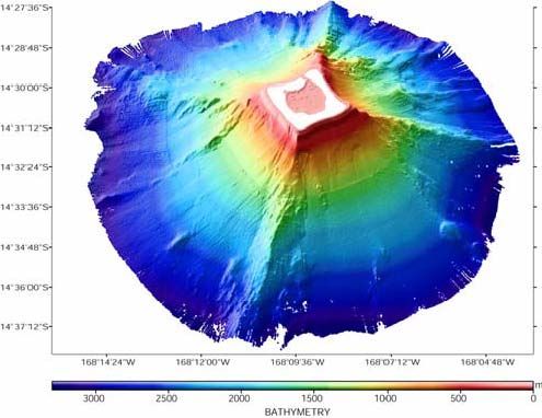
A

B

                                              Es tim ate d s pe cie s num be rs
                               20
 Estimated number of species

                               15
                               10
                               5
                               0

                                    1985   1990                         1995             2000

                                                            Y ear

Figure 1: Brian McArdle (2003) analysed the data from most of the reports listed in Section
16.10. The response of Samoan reefs to disturbance is a 15-year recovery from large-scale acute
factors (e.g., Colgan 1987 for Guam and Sano 2000 for Iriomote Island). During the first decade or
so, numerous small corals recruit to the area but a superficial view of the area looks as if recovery
is not occurring and one could fear that there has been a phase shift. However, each of the
abundant but tiny recruits start growing and the coral communities spring back remarkably rapidly
in the final half a decade (cf. Table 13 in Colgan 1987 and Table 1 in Sano 2000). The decrease of
local (within transect) diversity has been speculated to be a result of competition for space.

16.3 Geologic setting of American Samoan coral
reefs
The Samoan Islands are part of a 3000 km long chain of islands, seamounts,
shallow banks and atolls (Fig. 2). The U.S. territory of American Samoa consists
of five islands and two atolls. As with other archipelagoes on the Pacific Plate, the
islands that are formed over mantle plumes, also called hot spots (Morgan 1971),

                                                                                                   5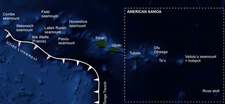
generally decrease in age from oldest in the northwest to youngest in the southeast
as the plate moves over the hotspot and continues towards the northwest. The
Samoan Islands are situated in the South Pacific Superswell – South Pacific
Isotopic and Thermal Anomaly (SOPITA) region, with unusually shallow seafloor
that is likely caused by anomalously hot and buoyant asthenosphere (Koppers et
al. 1998; Dickinson 1998, 2001).

Figure 2: American Samoa is situated in the Samoan Chain, a linear hotspot trace originating at
Vailulu’u Seamount (the active hotspot) and extending through the Manu’a group (Ofu, Olosega
and Ta’u) to Tutuila. The largest volcanic edifices in the Samoan group, Upolu and Savai’i, also
the largest islands, are part of western Samoa. The Samoan Chain then abruptly changes into a
series of seamounts extending via Pasco, Lallah Rookh, Waterwich and Combe until Alexa
Seamount in the west (not on map). The southern portion of the Pacific Plate is subducted into the
Tonga Trench, which turns into a transform fault called the Vitiaz Lineament. Stresses associated
with flexural warping of the Pacific plate at the plate boundary are generally considered
responsible for the rejuvenated volcanism at Savai’i/Upolu and the unusual appearance of the
Samoan Chain with the presently active volcanoes in the west, not the east. Rose Atoll is the only
seamount with a carbonate cap, likely the oldest structure in the chain, but not part of the Samoan
hotspot trail.

The volcanic features of this chain are oriented in a pattern consistent with an
origin caused by movement of the Pacific plate over a fixed hotspot (Natland
1980; Menard 1986). However, superficially observed, the age and size
progression appears backward if compared with the Hawaiian, Caroline, and
Society Islands. The northwestern end of the Samoan chain had originally been
considered to be located near Savai’i, an active volcano, while the southwestern
end of the chain is marked by Rose Atoll. In the other mentioned lineaments,
submerged volcanic edifices, drowned or capped by atolls, occur on the
northeastern ends of the chains – and not in the southweastern, like Rose. Since

                                                                                                  6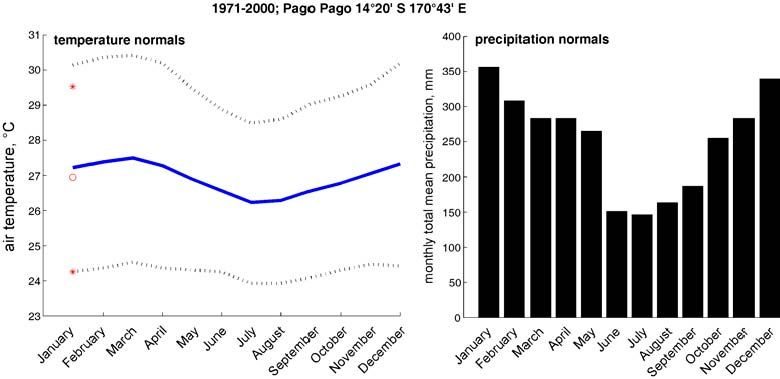
the Pacific Plate is rigid and drifts in a westerly or northwesterly direction, this
arrangement appears anomalous (Menard 1986) and the origin of the Samoan
chain as a hotspot trace has been disputed. Thus at one end of the chain would be
the inactive Rose Atoll while the other end would be characterized up by the
active volcanism at Savai’i – which is exactly opposite to the situation observed in
the other lineaments. However, to the west of Rose Atoll is situated Vailulu’u
submarine volcano (originally called Rockne volcano, then Fa’afafine; Johnson
1984; Hart et al. 1999), which has been identified as the active Samoan hotspot
(Hart et al 2000) and which is the true southwestern extreme of the Samoan chain.
Rose Atoll does not form part of the Samoan chain as such. The plume center that
is now situated at Vailulu’u appears to have migrated NE over the past 40 My
(Fig. 3) (Hart et al. 2004).

Figure 3: Surface motion of the Samoan plume over the last 40 my derived from a mantle
dynamics model of Steinberger (2000) and Steinberger et al (2002), taken from Hart et al (2004).
(by permission of Elsevier Science)

Further to the northwest of Vailulu’u are, as would be expected, young islands
with tholeitic lavas of the shield-building phase (like Ta’u, 1-3 Ma in age). The
larger and older western Samoan Islands are characterized by alcalic basalts of
secondary, rejuvenated activity (Fig. 4), which is also shown by series of cinder
cones along the islands’ axis and flows originating from there. In the Hawaiian
Islands this phase of rejuvenated vulcanism relative to the shield-building
vulcanism is seen largely as an effect of crustal loading (see chapter Rooney and
Fletcher). In Samoa, however, this activity has been linked to flexural warping of
the Pacific plate (Menard 1986). The northwestern Samoa Islands are situated
only 100-150 km from a flexural upwarp (the trench forebulge) that is maintained

                                                                                                   7
at the bend where the Pacific Plate changes from subduction in the Tonga trench
to the transform fault of the North Fiji Fracture Zone (Fig. 2). This upwarp may
be the cause of a 300 km rift that is observed along the Samoan islands (in
particular Savai’i and Upolu), manifested by an almost linear series of craters
striking parallel to the islands (Fig. 4).
While the original explanation for the rejuvenated volcanism in Samoa was a
response to Pacific Plate flexure associated with subduction in the Tonga Trench
(Menard 1986; Wright and White 1986; Natland 2004), Hart et al (2004) in
contrary believe that the volcanism in western Samoa is due to the islands
approaching another hotspot that has formed seamounts along other lineaments.
From the large western Samoan Islands, a series of seamounts extends further
west and follows the general Samoan lineament. Aging and geochemical data
suggest that seamounts as far away as Combe and Alexa have Samoan pedigree
and are thus part of the chain formed by the same hotspot (Hart et al 2004) (Fig.
2).
Figure 4: Generalized geologic map of Upolu in Western Samoa (from Stearns 1944) showing the
linear arrangement of most recent volcanism (Middle and late Quaternary cinder cones) along the
central axis of the island. The situation is similar at Savai’i. The steep side of the island has a
fringing reef, the less steeply sloping side of the island has a barrier reef that initiated on the
drowned edge of the island as it was subducted (modified from Stearns (1944) by permission of
the Geological Society of America).
The Samoan Island chain thus resembles the Hawaii/Emperor Chain as described
in Chapters 12 and 14 inasmuch as it also ends in a linear seamount chain.
Several significant differences exist between the Samoan and Hawaiian Chains. In
8Hawaii, the active mantle plume is situated underneath the emergent island of
Hawaii and has created a much bigger volcanic edifice than the Samoan hotspot at
Vailulu’u, which is not emergent. Hawaiian Islands progressively diminish in size
towards the west, and with the exception of subsidence and emergence due to
flexural volcano loading (Dickinson 2001) and some rejuvenated volcanism,
generally sink progressively deeper. In Samoa, islands get bigger towards the west
(Fig. 5), with abundant rejuvenated volcanism in particular at Savai’i and Upolu.
From then, the Samoan Islands brusquely give way to a seamount chain. No
gentle progression of sinking is observed. Between the Hawaiian and the Emperor
Seamount chain, an approximately 45 degree offset in direction is indication for
either a change in direction of the Pacific Plate at about 43 Ma (Dalrymple and
Clague 1976, Patriat and Achache 1984) or a southward drift of the Hawaiian
hotspot prior to 43 Ma (Norton 1995). Also the Samoan hotspot has not been
stable (Fig. 3), having drifted in a clockwise movement from its initiation at 40
Ma to 16.6 Ma in a northwesterly direction, and then in an easterly, then
southeasterly and finally northwesterly direction again (Steinberger 2002).
Steinberger et al (2004) suggest that motion of hotspots is influenced by plume-
distortion due to global mantle flow.
Figure 5: Different to the situation in the Hawaiian Islands, the islands along the Samoan Chain
get bigger towards the west. This is due to rejuvenated volcanism at Upolu and Savai’i in
association either with lithospheric flexure or appraoch to another hotspot. West of Savai’i the
chain continues as seamounts, east of the Manu’a group, is the active hotspot (modified from
Stearns (1944) by permission of Geological Society of America).
The islands of American Samoa are therefore mostly basaltic and have virtually
no carbonate cover (Fig. 6). Ta’u is a young, shield volcanic island that has been
modified by erosion, collapse and renewed volcanism, situated 48 km from
Vailulu’u. The main shield volcano that built Ta’u was the Lata Shield, within
which a caldera was formed that now forms the southern coastline of the island.
Smaller satellite shields were formed later (Stearns 1944, Stice and McCoy 1968,
9Izuka 2005). About nine miles from Ta'u is Ofu, which is also surrounded by coral
reefs. It is also made up by a complex of volcanic cones and is a shield volcano.
Tutuila is the largest (53 square miles) and most populated island (55,000 in 2004)
in American Samoa. It was built by several hot-spot shield volcanoes in the
Pliocene to Holocene and was at the active center at about 2 My (Hart et al. 2004).
Much of the island consists of a ridge of steep mountains that rise from sealevel to
about 710 m. The area of gentlest morphology is the Tafuna-Leone Plain at
Tutuila’s SW coast, with about 200 m relief. The plain was formed by volcanic
eruptions during the Holocene that covered parts of a pre-existing barrier reef
(Stearns 1944). While within the Samoan Chain the island elongations, vent
alignments and rift zones strike mostly ESE, Tutuila is aberrant in that it strikes
ENE (Walker and Eyre 1995). Based on the observation that Tutuila is
approximately in line with the North Fiji Fracture Zone, Walker (1999) speculates
that strike-slip motion occurred at the time of activity in the fracture zone (1.54-
1.03 Ma; McDougall 1985) coinciding with the positioning of Tutuila over the
hotspot. The strain associated with this motion would have aided in shaping the
island, suggested by en-echelon dyke complexes in the Masefau and Fagaitua
areas. Modern volcanism in southern Tutuila, associated with the Leone lavas that
cover the former barrier reef, is aligned approximately perpendicular to these
earlier rift zones. Although Tutuila is a young island (1.5 million years), it has
already submerged faster than the reefs can grow, leaving former barrier reefs as
submerged offshore banks (e.g., Taema Bank off the mouth of Pago Pago bay,
Nafanua Bank as a westward extension of Aunu’u Island, as well as a number of
other banks north of Tutuila). These banks are covered by diverse communities of
living corals, but the reef formation was slower than sealevel rise. Holocene
sealevel history of Tutuila is complex, since it lies on the one hand near the crest
of flexural upwarp of Savai’i, but also within the cone of flexural subsidence of
Ta’u (Dickinson 2001).
10Figure 6: Stages in the evolution of Tutuila as envisaged by Stearns (1944). a) The building phase
during the final extrusion of primitive olivine basalts, b) final stage during extrusion of trachyte
and differentiated lavas, c) cessation of volcanism and beginning of stream erosion, d) subsidence
and growth of a barrier reef on the subsided margin, e) further subsidence and submergence of the
barrier reef, extrusion of the Leone volcanics (modified from Stearns (1944) by permission of
Geological Society of America).
Rose Atoll (Fig. 7) is situated at 14° 32’S 168° 08’W, 240 km ESE of Tutuila at
the extreme eastern end of the Samoa Islands. It has a surface area of 640 ha, its
lagoon is only 2 km wide with a land area (Rose and Sand Islands) of 0.2 km2,
and therewith it is one of the smallest atolls of the world (Rodgers et al. 2003). It
is a pure carbonate islands and has no outcrops of basalts (however, whether
basalts found on Rose Atoll really are from there or not are a point of discussion;
Mayor 1924b; Rodgers et al. 2003). Rose Atoll was discovered by Louis de
Freycinet on 21 October 1819 on his voyage around the world on the Uranie and
Physicienne. He named it for his wife, who made the voyage with him. Rose
Atoll’s position outside the Samoan hotspot trail (Hart et al. 2004) and its obvious
older age than the hot spot to the west suggest that structurally it is not a part of
the Samoan islands. A rich literature exists for this far-away place (Rodgers et al.
1993; Wegmann and Holzwarth 2007). Besides being of geologic interest, Rose
Atoll is also the home to an important population of giant clams (~97% of
American Samoa’s entire population; Green and Craig 1999).
11Figure 7: Bathymetry of Rose Atoll as provided by NOAA bathymetry. Image courtesy NOAA
Pacific Islands Mapping Center.
The northernmost island of the Territory of American Samoa is Swains Island,
which is situated approximately 320 km north of the Samoan hot spot track and is
geologically part of the Tokelau volcanic chain. It is about 1 ½ miles long with a
central fresh water lake that is cut off from the ocean.
16.4 Climate and Oceanography
In general, the oceanographic conditions are excellent for coral growth which may
contribute to the resilience of corals on the forereefs. The average of nearshore
Secchi disk readings are 27.4 m (Whaylen and Fenner 2006) and hermatypic
corals and green algae can thrive to depths of at least 50 m in Fagatele Bay
National Marine Sanctuary. The water temperature is usually around 28° C on the
forereef (Fig. 8), although locally, in shallow pools on the backreef, the water
temperatures can reach 35° C and fluctuate through a range of 6° C in a few
hours. The tidal range is about 1 m.
The climate is characteristic of the tropics with high humidity (averages about 80
percent) and warm air temperatures (21 to 32° C). Rainfall averages about 5 m per
year (Fig. 9) and so careless land management often leads to large-scale runoff of
sediment and rubbish onto the reefs after heavy rains.
12Figure 8: Synthetic Hadley Center HadlSST sea surface temperature for the 1x1 degree tiles
centered in Tutuila and Ta’u from 1977 to 2006 (Crown Copyright. Used by permission of Hadley
Center, UK).
Figure 9: Atmospheric temperature record and precipitation at Pago Pago airport, Tutuila (Source
NOAA, National Climatic Data Center). Normals are uninterrupted measurements for three
consecutive decades. Original data were translated into metric units. Lines in temperature graph
represent monthly means, red circle annual mean, stars annual means of minima and maxima.
16.5 History of Biological Research
Quantitative surveys of coral reefs in American Samoa began 90 years ago in
Pago Pago Harbor (Mayor 1924a) with transects set up at Aua and Utulei by
Alfred Mayor in 1917 (Fig. 10). The transect at Aua was evaluated for ecology,
the other primarily for drilling cores. Aua was resurveyed in 1973 (Dahl and
Lamberts 1977), 1980 (Dahl 1981), 1995 (Green et al. 1997), 1999 (Birkeland and
Green 1999), 2000 (Birkeland and Belliveau 2000), and 2002 (Green 2002), and
is now being resurveyed at every opportunity. Alfred Mayor reported rich coral
13communities on the reefs around Aua and his photographs show abundant
Acropora colonies exposed at low tide (Fig. 10) at the outer end of the transect
(Mayor 1924a). Whereas the reefs on the outer coast are renowned for their
resilience, the reefs within Pago Pago Harbor began to succumb to chronic stress
with the establishment of two tuna canneries in the inner harbor that began
operation in 1956. A chronology of major events affecting coral reefs in American
Samoa, and transect surveys of corals and their reports, are given in Section
16.10. Alfred Mayor also studied rates of growth of scleractinians and Lewis Cary
studied growth of alcyonaceans between 1917 and 1920.
Figure 10: Two scans from Mayor (1924a). Left panel: The map showing Mayor’s and Cary’s
transects. Right panel: Acropora exposed on the intertidal near the Aua transect line (reprinted
from Mayor 1924a, with permission of the Carnegie Institution, Washington, DC).
Lewis Cary (1931) also began surveys in 1917. His transects at Utulei were across
the harbor from Mayor’s Aua transect (Fig. 10). Cornish and DiDonato (2004)
repeated Cary’s transects to the extent that they still existed in 2002 (Fig. 11).
Cary also obtained a series limestone core samples 85, 175, and 280 m from shore
along Transect 1 to basalt bedrock at 20, 40 and 40 m, respectively. Alcyonaceans
were prevalent along Cary’s transects and 75% of the reef flat pavement was
composed of compacted spicules deposited by the hermatypic alcyonaceans.
Sinularia polydactyla (Fig. 12 a) is a major hermatypic reef-building species of
soft coral in some locations in the Pacific, and Cary’s reef cores at Utulei showed
that the compacted spicules of S. polydactyla (presumably Cary’s Sclerophytum
densum) formed a major portion of the 40 m thick reef structure. Cornish and
DiDonata (2004) pointed out that the reclamation of the reef for construction and
mortality of the alcyonaceans due to pollution from the canneries and other
14humanactivities has made the reef framework substantially more vulnerable to
erosion.
Figure 11: Changes in soft coral cover in line 1 and in line 5 between 1917 and 2002 in the Utelei
transect from Cornish and DiDonato (2004) with permission of Elsevier Science.
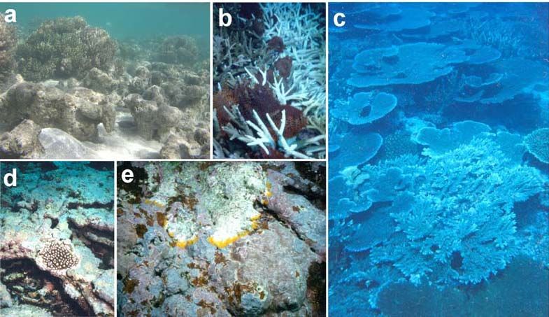
15Figure 12. (a) The hermatypic alcyonacean Sinularia polydactyla forming solid reef framework
(picture from the the Piti Bombholes, Guam, since the species is by far not as common now as
when encountered by Mayor and Carey). (b) Phalanx of Acanthaster planci thoroughly removing
living coral tissue from the coral community on the western coast of Aunu’u island in 1979. (c) A
complex system of acroporid corals competing for space on the western forereef slope of Aunu’u
Island. (d) Crustose coralline algae in Fagatele Bay, American Samoa, enhances coral recovery
and reef community resilience by binding the loose substrata after a hurricane. (e) Coralline Lethal
Orange Disease (CLOD), a bacterial film that move across living coralline algae and leaving bare
calcium carbonate in its wake.
Surveys of corals and reef fishes around American Samoa became a regular
endeavor starting in 1979 with 1978/79 outbreak of Acanthaster planci (Fig. 12
b). The Government of American Samoa Department of Marine and Wildlife
Resources sponsored surveys of corals and fishes around American Samoa in
1979, 1982, 1985, 1988, 1991, 1995, 1996, 1997, 1998, 2001, 2002 (Fig. 13) and
2005. A reef at Ofu was surveyed in 1993 and 2000, Swains Island in 1996, Rose
Atoll in 1997 (Wegmann and Holzwarth 2007).
Figure 13: Mean living coral cover (+/- se) on some of the islands of American Samoa during
recovery following two hurricanes and a major coral bleaching event in the early 1990s (Birkeland
et al. 2004).
In April 1985, upon decision by the Government of American Samoa and the US
Department of Commerce Marine Sanctuary Program to establish a National
Marine Sanctuary at Fagatele Bay, permanent transect markers were established in
Fagatele Bay. Surveys of corals and fishes were performed in 1985, 1988, 1995,
1998, 2001 and 2004. Another survey is planned for August 2007 and it is
expected that they be repeated every third year.
The study of acclimatization and adaptation of corals to climate change, in 1999
monitoring of the wide range of water temperatures in small shallow backreef
16pools on Ofu island was begun. In this area, temperatures could fluctuate daily by
6° C (Fig. 14), yet about 80 species of corals appeared to be in good health (Craig
et al. 2001). This diverse community of Ofu lagoon corals appears to be also
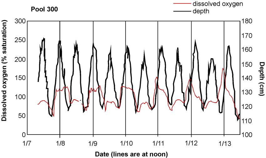
resilient to wide daily fluctuations in pH (Fig. 15) and dissolved oxygen (Fig. 16)
and thus may offer some insight into mechanisms of corals to respond to ocean
acidification and other global changes in the physical environment. The National
Park Service, in Cooperation with the USGS, the University of Hawaii, the
Rosenstiel School of Marine and Atmospheric Science, and Stanford University,
set up an itinerant marine laboratory in the American Samoa National Park on Ofu
for long term studies of biochemical, physiological and genetic mechanisms of
coral adjustment to climate change.
Figure 14:. Fluctuating hourly seawater temperatures in the backreef lagoons at Ofu Island,
American Samoa (data communicated by Craig et al. 2001).
Figure 15: Fluctuating hourly seawater pH measurements in the backreef lagoons of Ofu Island.
17Figure 16: Fluctuating levels of dissolved oxygen in seawater measurements in the backreef
lagoons of Ofu Island.
16.6 Biodiversity
The total number of scleractinian coral species names in the technical reports of
the transect surveys to date is 337, but removal of synonymies and unidentified
species reduce the number of names to 329. This number of coral species fits what
would be expected along the west to east reduction in diversity across the Pacific.
Fagatele Bay National Marine Sanctuary is only one quarter square mile (66
hectares, or 0.66 km2) in area, but hosts 200 species of coral and 271 species of
reef fish.
Stony (scleractinian) corals appear to have spread eastward across the Pacific
more effectively than have the soft (octo-) corals. Whaylen and Fenner (2006)
report 10 genera of octocorals ( with Cladiella being by far the most prevalent), 2
genera of antipatharians (black corals), 3 genera of zoanthids, and 3 genera of
coralliomorpharia. Coles et al. (2003) report about 20 species of octocorals, 5
anemonies, and 6 zoanthids. Although octocorals are an order of magnitude less
diverse than the scleractinians (in striking contrast to the smaller, more continental
western Atlantic), Sinularia polydactyla nevertheless is (or was half a century
ago) a major reef builder. While Cary (1931) found Nephthya flexile to be
18abundant in areas protected from wave action, and particularly well fitted to
withstand sedimentation, it now seems to be extinct in American Samoa.
Also Echinoderm species richness decreases from west to east across the tropical
Pacific. From Indonesia to the Marshall Islands to American Samoa, respectively,
the number of coral-reef crinoid species are 91, 6, 6; asteroids 66, 17, 11;
ophiuroids 142, 42, 23; echinoids 43, 17, 10; holothuroids 141, 23, 16 (Birkeland
1989).
About 945 species of reef-associated fishes are known from American Samoa
(Fig. 17). This is consistent with the gradient in decreasing diversity from west to
east across the central Pacific (Allen 2003).
Figure 17: The number of fish species near American Samoa in comparison with the number of
fish species near other locations. The data are from Allen 2003.
16.7 Zonation and Community Patterns
On a scale larger than depth zonation, differences exist in distributions of some
reef organisms on differently exposed sides of the islands. Whaylen and Fenner
(2006) and Sabater and Tofaeono (2006) found significantly more cover of
crustose coralline algae on the south coast of Tutuila than on the north coast and
conversely, filamentous algae was more prevalent on the north coast. Also Rose
Atoll has already been noted by Mayor (1924b) as having an exceptionally well-
developed shallow calcareous algae ridge largely made up by Porolithon sp. He
noted that Rose Atoll had the densest growth of calcareous algae he had
encountered anywhere, so much that it could be called a “Lithothamnion-atoll
rather than a coral atoll” (Mayor 1924b, p. 77). Swains Island, on the other hand,
19shows the dominance of corals as so often observed elsewhere in American
Samoa (Fig. 18).
Figure 18: Benthic cover on Rose Atoll and Swains island, showing the preponderance of
coralline algae on Rose Atoll (data redrawn from Vroom et al 2006).
16.8 Effects of Human Activities and Conservation
Issues
The American Samoa Environmental Protection Agency ranked the watersheds on
Tutuila in terms of influence of human activities. Whaylen and Fenner (2006)
assessed the correlations between human activities and living coral cover at 35
sites from the combined data from their own surveys and the surveys of Sabater
and Tofaeono (2006) and found no significant correlation. Likewise, they did not
find a correlation between human activities and either crustose coralline algal
cover or filamentous algal cover. On an island-wide scale, human activities are
not correlated with the patterns of distribution of the benthic communities,
partially because the effects of human activities are confounded or masked by the
major effects of natural disturbances such as hurricanes, bleaching from thermal
and UV stress, and predation by Acanthaster planci.
2016.8.1 Land management
On a smaller scale, there are very obvious effects of human activities. The reef
flats onto which the rivers empty at the base of watersheds can be damaged from
chronic sedimentation. About the only coral now residing on the reef flat at the
mouth of Amanave Bay is Leptastrea purpurea, although the structure of the reef
is made up of skeletons of a diverse array of corals which attest to healthier reef
conditions in the past. Fagasa Bay is silty and the coral cover is very low (6.8%).
The crustose coralline algal cover is also low (9.5%), but the filamentous algal
cover is especially high (45%, Whaylen and Fenner 2006). Luxuriant and diverse
coral reefs existed in Pago Pago Harbor a century ago, but reefs of the inner
harbor were obliterated in the 1920s to allow construction of a US naval base.
About 95% of the reefs in the inner harbor have been buried in silt (Wass 1983).
In the 1940s, further inshore areas were dredged for landfill and the inner Utulei
reef was filled for development of a tank farm and to widen the coastal road. In
1956, the first of two tuna canneries began operation on the north shore of the
inner harbor. Untreated sewage, polluted streams, and untreated waste from two
canneries caused the death of most corals in the inner harbor and corals in the mid
to outer harbor were also not doing well. In 1992, the tuna canneries extended
wastewater outflow pipes to the outer harbor where water flow is stronger. In the
late 1990s, coral colonies began to be observed growing in the inner harbor and
Acropora hyacinthus was observed recruiting and growing near the Rainmaker
Hotel at the boundary of the inner and outer harbor (Green 2002).
16.8.2 Fishing pressure
The 945 species of reef fishes in American Samoa are slightly more than would
be expected at the longitude of the islands on the west to east gradient in numbers
of coral-reef fish species (Fig. 17). This could indicate that the full array of
habitats necessary to provide the necessary conditions for the life history stages
for reef fishes is still in operation. The lack of habitat could lead to local
extinction and so the wealth of species indicates that the critical habitats are still
represented.
Although the number of species of reef fishes in American Samoa is as great as
would be expected, their biomass is remarkably low (Figs. 19 and 20).
Commercial fishing has been in effect for a few decades as the human population
21grew and residents began to earn a salary and purchase more of their food at the
market. Before 1994, most commercial fishing was done by handlines, nets or
spearfishing by free diving. From 1994 to 2002, the commercial fishermen used
underwater lights and scuba to harvest sleeping fish. The commercial catch
increased 15-fold (Fig. 21) until eloquent protests at public hearings compelled
the Governor to issue an executive order to stop night fishing with scuba until the
matter could be discussed and new regulations developed.
Figure 19: The biomass of fishes on American Samoan reefs in comparison with the biomass of
fishes typical of the Atlantic and Pacific reefs from literature from 1983 or prior times.
6
"Lightly fished" reefs
"Lightly fished"
Fished reefs
reefs
5 Fished
Tutuila reefs
Island reefs
Tutuila Island reefs
Average biomass of 11
"lightly fished" mid
Fish biomass (mt/ha) .
4
Pacific reefs
3
Philippine model showing
2 "very high" biomass (>0.75
mt/ha) (Hilomen et al. 2000)
1
0
NWHI-FFS
NWHI-P&H
NWHI-Necker
NWHI-Lisianski
NWHI-Nihoa
NWHI-Maro
NWHI-Gardner
H-Molokai
NC-Cook's
NWHI-Laysan
NWHI-Kure
H-Maui
NC-Francais
L2-Palmyra
L1-Palmyra
H-Oahu
NC-east
L1-Kiritimati
L2-Kiritimati
H-Kauai
L1-Kingman
L1-Tabuaeran
L2-Tabuaeran
H-Hawaii
NC-west
AS1-Tutuila (2002)
AS2-Tutuila (2004)
AS1-Tutuila (1996)
AS2-Tutuila (2006)
AS2-Tutuila (2002)
H-Kahoolawe
22Figure 20: Biomass of coral-reef fishes on selected central Pacific islands. (a) White bars indicate
"lightly fished" reefs: NWHI - Northwest Hawaiian Is. (Friedlander & DeMartini 2002), L1 -
Line Is. (DeMartini et al. in review), L2 - Line Is. (Stevenson et al. 2007), NC (New Caledonia)
(Letourneur et al. 2000). (b) Gray bars - fished reefs: H - Hawaii main islands (Friedlander &
DeMartini 2002), L1 - Line Is. 9 (DeMartini et al. in review), L2 - Line Is. (Stevenson et al. 2007),
(c) Dark bars - American Samoa: AS1 - Tutuila (Green 2002), AS2 - Tutuila (R. Brainard, NOAA
CRED, pers. com.).
Figure 21: Estimated annual harvest of parrotfishes on Tutuila Island from 1978 to 1997 (Page
1998).
The biomass of fish species selected for surveying averaged 56 g/m2 with a range
of 29 to 114 g/m2, or 56 mt/km2 (0.56 mt/ha). The typical biomass of fishes (Fig.
19) on the western tropical Atlantic coral reefs was 160-200 mt/km2 (Randall
1963, Munro 1983) and on Pacific coral reefs 93-239 mt/km2 (Goldman and
Talbot 1976, Williams and Hatcher 1983). However, this low biomass is at a level
characteristic of areas heavily fished (Fig. 20).
The number of species and abundance of coral-reef fishes are not noticeably
different than what might be expected for central Pacific reefs, but the scarcity of
larger fishes in recent years is striking (Figs. 22 and 23). Large serranids were
seen and caught more regularly in the 1980s than they are now (pers. observ.). In
a survey of 11 sites in 2005, only four individual Cheilinus undulatus were seen
with a mean length of 64 cm, the largest individual being only 110 cm, about half
of the maximum attainable size. Only a single shark, a whitetip reef shark
Triaenodon obesus, were observed.
23Figure 22: Lengths and densities of standing stocks of targeted fish (>19 cm, species combined)
at 17 sites on Tutuila Island in 2002 (modified from data from Green 2002).
Figure 23: Mean density (+/- se) of large reef fishes on Tutuila and in the Manu’a Islands in 2002
(modified from data from Green 2002).
The extraordinarily low biomass of fishes and scarcity of large fishes might be
explained by fishing pressure on the larger fishes. The shallow fringing reefs are
all accessible close to shore. Samoans have been fishing the reefs of American
Samoa for about 3,300 years. Artisanal fishers can severely exploit and degrade
fisheries resources, especially the larger fishes, shortly after prehistoric arrival
(Wing and Wing 2001).
Motivation to manage requires a realistic perception of the state of the resources,
and so the sliding baseline is one of the more powerful phenomena undermining
responsible programs. A recent (18 June 2007) issue of the Samoan News
24reported a statement from a scientist that the American Samoan “fisheries are
clearly sustainable, and marine protected areas for management purposes are not
needed as the fisheries are replenishing themselves.” This statement must be
based on a view that the low biomass and scarcity of large fishes are the natural
characteristics of reef communities of American Samoa. When monitoring of
resources begins after stocks have been substantially reduced, the perception of
what is natural can be lowered several fold. A heuristic example of how the scale
of assessment can potentially alter our perceptions, Hilomen et al. (2000)
summarized the findings of fish biomass on 227 transects from throughout the
Philippine Archipelago. In this report, Hilomen et al. (2000) strongly emphasized
that the condition of the majority of coral-reef fish stocks in the Philippines are
very poor. They were aware of the true situation. But in presenting their findings,
they categorized the top 11% in the “high” (0.35 – 0.75 mt / ha) to “very high”
(>0.75 mt / ha) relative to the range of conditions within the Philippines. These
top 11% were indeed high or very high within the context of present day
Philippines reef fish stocks, but the high or very high levels of biomass were 1/9
or ¼ the average level for lightly fished areas (Fig. 20). One of the very high sites
in the Philippines had a stock of 2.20 mt / ha and so the reefs of the Philippines
probably have potential for higher standing stocks if the fishing pressure were
released. Hilomen et al. (2000) clearly expressed the dire state of overfishing in
the Philippines, but we believe that if the levels of biomass characterized as
“high” or “very high” in terms of the spread of the data at hand were taken out of
context, this could facilitate a sliding baseline in general perception.
16.9 Present Status of Reef Health
The coral communities on American Samoa are a rich mosaic of patches in
various stages of recovery from an array of disturbances such as crown-of-thorns
predation, hurricanes, blast-fishing, ship groundings, and bleaching from warm-
water stress (Section 16.10). On the outer reef slopes disturbances have generally
been acute, and recovery started soon after the event (Green et al. 1999). Some
localized and well-defined areas experience chronic stresses, such as
sedimentation at the mouths of rivers or in the backs of bays, and have not been
recovering for decades. If the seawater warmings become more frequent,
widespread and of longer duration, and if the increased atmospheric carbon leads
25to seawater acidification, the coral communities on the forereef might start to lose
their resilience.
The capacity of coal communities on forereefs to recover from disturbances is
probably partially a result of the ability of crustose coralline algae to bind loose
rubble into a stable substratum (Fig. 12d). Crustose coralline algae seem
especially prevalent on the forereefs of American Samoa. Six years after the 1979
outbreak of Acanthaster planci, the coralline algae generally covered about 57%
of the forereef slope, with about 65% cover at 3m and 5 m depths (Birkeland et al.
1987). Other algae covered about 21% of the substrata. Living coral cover
averaged 12.6%, but was patchily distributed during this period of recovery, with
results of 30-m transects within Fagatele Bay at any one time ranging from 0.9%
to 64.4%.
More recent surveys have found that the reefs are still in similar condition, but
further along in recovery from more recent disturbance events, i.e., damaging
hurricanes in 1990 and in 1991, and serious bleaching in 1994. Whaylen and
Fenner (2006) and Sabater and Tofaeono (2006) found 28% and 27% cover on 11
and 24 sites (for a total of 35 different sites) around Tutuila. Whaylen and Fenner
(2006) reported an average 35% cover by crustose coralline algae and concluded
that in recent times, the prevalence of living corals and crustose coralline algae,
and the scarcity of macroalgae (2% cover at 11 sites) indicated that the coral reef
community is presently in good health. In most other areas, especially forereef
sites, the reefs of American Samoa are still resilient compared to those of the
western Atlantic (Gardner et al. 2003, Pandolfi et al. 2003). Only reefs Amanave,
Fagasa and Pago Pago have not recovered for decades. While coral diseases are
common on American Samoan reefs, especially neoplasms or “tumors” and white
syndromes, they presently do not appear to have a substantial effect on the coral
populations to date. However, increasing water temperature, sedimentation and
pollution might stress corals and weaken their resistance and coral disease may
become a more serious factor in the future if climate change becomes more
influential.
26Uncontrolled human population growth can interact synergistically with the steep
topography of the islands and the rainfall to exacerbate environmental problems
(Craig et al. 2000). Since rainfall averages 5 m per year in the mountainous areas
in which most of the land has a slope greater than 70%, heavy rains can cause
erosion and deliver spectacular amounts of debris, garbage and sediment onto the
reefs of Pago Pago and other watersheds. Mayor (1924a) reported on torrential
rains that delivered silt that blanketed the reefs and killed a substantial number of
corals. Wells (1988) described significant portions of reefs in Pago Pago, Faga’ita,
and Leone Bays as having been buried under sediment. Organic pollution and
untreated sewage have also locally affected reefs around American Samoa (Wells
1988). The greatest threats, however, may ultimately arise from climate change
and acidification of ocean waters, while increased input of sediment and pollution
from increased population growth may reduce the vitality and resilience of corals
and increase their vulnerability to succumbing to disease.
Not only corals, but also crustose coralline algae are infected by at least two
diseases that are especially common in Fagatele Bay National Marine Sanctuary:
a bacterium - Coralline Lethal Disease (CLOD) and a fungus - “lichen-like” black
crust disease. CLOD grabs attention as a bright orange band followed by a white
patch (Fig. 12 e). Despite the fact that CLOD is frequently noticed, the crustose
coralline algae appear to grow fast enough to replace any surface killed by CLOD.
At the present time, CLOD and the fungal disease do not appear to be a threat.
While corals on the forereef appear resilient, the fish populations do not appear to
recover their normal size distributions. Although the diversity and abundance of
fishes may be as expected, the biomass is only about a quarter of that on a lightly
fished coral reef (Fig. 20) and very few large individuals are seen. The apex
predators are very rare. With increased human population density and advances in
technology, overfishing may have become a chronic problem.
27Figure 24. Coastal community on Olosega. The human populations are concentrated along the
coast because of the steep terrain on American Samoa.
16.10 A chronology of major events and research
on coral reefs in American Samoa
1917-1920: First Alfred A. Mayor and then Louis Cary work on Tutuila’s coral
reefs. Mayor also visits the other islands and Rose Atoll (Mayor 1924a,b;
Cary 1931)
1920s: Destruction of corals reefs on southern shore of inner Pago Pago Harbor
by construction of naval base
1938: Outbreak of Acanthaster planci
1940s: Fill over inner Utulei Reef for tank farm
1954: Construction of first tuna cannery
1960s: Fill over start of Cary Transects 1 and 5 for widening of coastal road
281963: Construction of second tuna cannery
1973: First re-survey of Mayor’s transects (Dahl and Lamberts 1977)
1978: Outbreak of crown-of-thorns starfish Acanthaster planci
1979: Resource assessments in Fagatele Bay and monitoring (Birkeland et al
1985, 1987; Dahl 1981)
1981: Tropical cyclone Esau
1985: Fagatele Bay National Marine Sanctuary officially established by US
Department of Commerce and American Samoa Department of Commerce
1987: Tropical cyclone Tusi hits Manu’a Islands hard
1988: Further resource assessmnet work (Birkeland et al 1994)
1990: Tropical cyclone Ofa hits Tutuila hard
1991: Tropical cyclone Val hits Tutuila hard – 9 ships grounded on Pago Pago
reefs
1991, 1992: Coastal resources inventory (Maragos et al 1994).
1992: Extension of industrial wastewater from canneries from inner Pago Pago
Harbor to the outer harbor
1993: Surveys on Ofu for the National Park of American Samoa (Hunter et al.
1993)
1994-2002: Commercial fishing at night with scuba
1994: Major coral bleaching associated with unusually warm seawater
1995-7: Surveys in Fagatele Bay and the rest of American Samoa including
Swains Island and Rose Atoll (Birkeland et al 1996, 2003; Mundy 1996,
Green 1996 a,b; Green et al 1997a,b)
1998: Extreme low tides kill exposed corals
1998: Surveys of Swains Island (Page and Green 1998)
1998-2001: Numerous surveys on Tutuila (Green and Hunter 1998; Birkeland and
Green 1999; Birkeland et al 2004)
2000: 9 ships finally removed from Pago Pago reefs. Prior and after the removal,
resurveys of Mayor’s Aua transect (Birkeland and Green 1999; Birkeland
and Belliveau 2000)
2002: Minor coral bleaching associated with unusually warm seawater
2002: Numerous coral reef surveys (Fisk and Birkeland 2002; Green 2002;
Cornish and DiDonato 2004)
2003: Surveys for introduced marine species (Coles et al 2003)
292003: Major coral bleaching associated with unusually warm seawater
2004: Tropical cyclone Heta
2004: More monitoring in Fagatele Bay (Green et al 2005)
2005: Extreme low tides kill exposed corals
2005: Tropical cyclone Olaf hits Manu’a Islands hard
LITERATURE CITED
Allen GR (2003) Reef fishes of Milne Bay Province, Papua New Guinea. Pages 46-55 In Allen
GR, Kinch JP, McKenna SA, Seeto P (eds) A rapid marine biodiversity assessment of Milne Bay
Province, Papua New Guinea - Survey II (2000). RAP Bulletin of Biological Assessment 29.
Conservation International, Washington, DC, USA
Birkeland C, Randall RH, Amesbury SS (1985) Coral and reef-fish assessment of the Fagatele Bay
National Marine Sanctuary. Report to NOAA.126 pp
Birkeland C, Randall RH, Wass R, Smith BD, Wilkens S (1987) Biological resource assessment of
the Fagatele Bay National Marine Sanctuary. NOAA Technical Memorandum NOS MEMD 3. 232
pp
Birkeland C (1989) The influence of echinoderms on coral-reef communities. Pages 1-79 In M.
Jangoux and J.M. Lawrence (eds), Echinoderm Studies 3. Balkema, Rotterdam
Birkeland C, Randall RH, Amesbury, SS (1994) Coral and reef-fish assessment of the Fagatele
Bay National Marine Sanctuary. Report to the National Oceanic and Atmospheric Administration
U.S. Department of Commerce. 126 pp
Birkeland C, Randall RH, Green AL, Smith BD, Wilkins S (1996) Changes in the coral reef
communities of Fagatele Bay National Marine Sanctuary and Tutuila Island (American Samoa)
over the last two decades. Report to the National Oceanic and Atmospheric Administration, U.S.
Department of Commerce, 225 pp
Birkeland C, Green AL (1999) Resurvey of the Aua Transect prior to the ship removal. Report to
the National Oceanic and Atmospheric Administration. 10 pp
Birkeland C, Belliveau SA (2000) Resurvey of the Aua Transect After the Ship Removal. Report
to the National Oceanic and Atmospheric Administration U.S. Department of Commerce. 2 pp
Birkeland C, Randall RH, Green AL, Smith BD, Wilkins S (2003) Changes in the coral reef
communities of Fagatele Bay National Marine Sancturary and Tutuila Island (American Samoa),
1982-1995. Fagatele Bay National Marine Sanctuary Science Series 2003-1
Birkeland C, Green AL, Mundy C, Miller K (2004) Long term monitoring of Fagatele Bay
National Marine Sanctuary and Tutuila Island (American Samoa) 1985 to 2001: summary of
surveys conducted in 1998 and 2001. Report to the National Oceanic and Atmospheric
Administration, U.S. Department of Commerce, 158 pp
Cary LR (1931) Studies on the coral reefs of Tutuila, American Samoa, with special reference to
the Alcyonaria. Papers from the Tortugas Laboratory, Carnegie Instit Wash 37:53-98
Coles SL, Reath PR, Skelton PA, BonitoV, DeFelice RC, Basch L (2003). Introduced marine
species in Pago Pago Harbor, Fagatele Bay and the National Park Coast, American Samoa. Bishop
Museum Technical Report No 26, Honolulu.182 pp
Colgan MW (1987) Coral recovery on Guam (Micronesia) after catastrophic predation by
Acanthaster planci: a study of community development. Ecology 68: 1592-1605
Cornish AS, DiDonato EM (2004) Resurvey of a reef flat in American Samoa after 85 years
reveals devastation to a soft coral (Alcyonacea) community. Marine Pollution Bulletin 48:768-777
Craig PC, Birkeland C, Belliveau S (2001) High temperatures tolerated by a diverse assemblage of
shallow-water corals in American Samoa. Coral Reefs 20:185-189
Dahl AL, Lamberts AE (1977) Environmental impact on a Samoan coral reef: a resurvey of
Mayor's 1917 transect. Pacific Science 31:209-319
Dahl AL (1981) Monitoring coral reefs for urban impact. Bulletin of Marine Science 31:544-551
Dalrymple GB, Clague DA (1976) Age of the Hawaiian-Emperor bend. Earth Planet Sci Lett
31:313-329
30DeMartini EE, Friedlander AM, Sandin S, Sala E (in review) Predation effects revisited: structure
of shallow-reef fish assemblages along an exploitation gradient in the northern Line Islands,
central Pacific
Dickinson WR (1998) Geomorphology and geodynamics of the Cook-Austral island-seamount
chain in the Saouth Pacific Ocean: implications for hotspots and plumes. Int Geol Rev 40:1039-
1075
Dickinson WR (2001) Paleoshoreline record of relative Holocene sea levels on Pacific islands.
Earth-Sci Rev 55:191-234
Fisk D, Birkeland C (2002) Status of coral communities in American Samoa. A re-survey of long-
term monitoring sites. Report to the Department of Marine and Wildlife Resources, Government of
American Samoa. 134 pp
Friedlander AM, DeMartini EE (2002) Contrasts in density, size, and biomass of reef fishes
between the Northwestern and the Main Hawaiian Islands: the effects of fishing down apex
predators. Mar Ecol Prog Ser 230:253-264
Gardner TA, Côté IM, Gill JA, Grant A, Watkinson A (2003) Long-term region-wide declines in
Caribbean corals. Science 301:958-960
Garrison VH, Shinn EA, Foreman WT, Griffin DW, Holmes CW, Kellogg CA, Majewski MS,
Richardson LL, Ritchie KB, Smith GW (2003) African and Asian dust: from desert soils to coral
reefs. BioScience 53:469-480
Goldman B, Talbot FH (1976) Aspects of the ecology of coral reef fishes. In Jones OA Endean R
(eds) Biology and Geology of Coral Reefs III. Biology 2. Academic press, NY pp125-254
Green AL (1996a) Status of the coral reefs of the Samoan Archipelago. Report to the Department
of Marine and Wildlife Resources, Government of American Samoa. 120 pp
Green AL (1996b) Coral reefs of Swains Island, American Samoa. Report to the Department of
Marine and Wildlife Resources, Government of American Samoa. 2 pp
Green AL (2002) Status of coral reefs on the main volcanic islands of American Samoa: a
resurvey of long term monitoring sites (benthic communities, fish communities, and key
invertebrates). Report to Department of Marine and Wildlife Resources, Pago Pago, American
Samoa. 135 pp
Green AL, Birkeland CE, Randall RH, Smith BD, Wilkins S (1997a) 78 years of coral reef
degradation in Pago Pago Harbour: a quantitative record. Proc 8th Internat. Coral Reef Sym
2:1883-1888
Green AL, Burgett J, Molina M, Palawski D, Gabrielson P (1997b) The impact of a ship
grounding and associated fuel spill at Rose Atoll National Wildlife Refuge, American Samoa. A
report to the US Fish and Wildlife Service, Honolulu. 60 pp
Green AL, Birkeland CE, Randall RH (1999) Twenty years of disturbance and change in Fagatele
Bay National Marine Sanctuary, American Samoa. Pacific Science 53:376- 400
Green A, Craig P (1999) Population size and structure of giant clams at Rose Atoll, an important
refuge in the Samoan Archipelago. Coral Reefs 18:205-212
Green AL, Hunter C (1998) A preliminary survey of the coral reef resources in the Tutuila Unit of
the National Park of American Samoa. Final report to the US National Park Service, American
Samoa. 42 pp
Green A (2002) Status of the coral reefs on the main volcanic islands of American Samoa: a
resurvey of long term monitoring sites (benthic communities, fish communities, and key
macroinvertebrates). Report to the Department of Marine and Wildlife Resources, Government of
American Samoa.135 pp
Green AL, Miller K, Mundy C (2005) Long term monitoring of Fagatele Bay National Marine
Sanctuary. Tutuila Island, American Samoa: results of surveys conducted in 2004, including a re-
survey of the historic Aua transect. Report to US Department of Commerce and American Samoa
Government. 93 pp
Hallock P, Müller-Karger FE, Halas JC (1993) Coral reef decline. Natl Geogr Res Explor 9:358-
378
Hart SR, Staudigel H, Kurz MD, Blusztajn J, Workman R, Saal A, Koppers A, Hauri EH Lyons S
(1999) Fa’afafine volcano: the active Samoan hotspot. Trans Am Geophys Union (Eos) 46, F1102,
Suppl. [abs].
Hart SR, Staudigel H, Koppers AAP, Blustajn J, Baker ET, Workman R, Jackson M, Hauri E,
Kurz M, Sims K, Fornari D, Saal A, Lyons S (2000) Vailulu’u undersea volcano: the new Samoa.
Geochem Geophys Geosyst GC0000108: 1-13
Hart SR, Coetzee M, Workman RK, Blustajn J, Johnson KTM, Sinton JM, Steinberger B,
Hwakins JW (2004) Genesis of the Western Samoa seamount province: age, geochemical
fingerprint and tectonics. Earth Planet Sci Lett 227:37-56
31You can also read