THE OCCURRENCE OF VERTEBRATE AND INVERTEBRATE FOSSILS IN A SEQUENCE STRATIGRAPHIC CONTEXT: THE JURASSIC SUNDANCE FORMATION, BIGHORN BASIN ...
←
→
Page content transcription
If your browser does not render page correctly, please read the page content below

THE OCCURRENCE OF VERTEBRATE AND INVERTEBRATE FOSSILS IN
    A SEQUENCE STRATIGRAPHIC CONTEXT: THE JURASSIC SUNDANCE
    FORMATION, BIGHORN BASIN, WYOMING, U.S.A
    Author(s): SHARON K. MCMULLEN, STEVEN M. HOLLAND, and F. ROBIN O'KEEFE
    Source: PALAIOS, 29(6):277-294. 2014.
    Published By: Society for Sedimentary Geology
    URL: http://www.bioone.org/doi/full/10.2110/pal.2013.132

    BioOne (www.bioone.org) is a nonprofit, online aggregation of core research in the biological, ecological, and
    environmental sciences. BioOne provides a sustainable online platform for over 170 journals and books published
    by nonprofit societies, associations, museums, institutions, and presses.
    Your use of this PDF, the BioOne Web site, and all posted and associated content indicates your acceptance of
    BioOne’s Terms of Use, available at www.bioone.org/page/terms_of_use.
    Usage of BioOne content is strictly limited to personal, educational, and non-commercial use. Commercial inquiries
    or rights and permissions requests should be directed to the individual publisher as copyright holder.

BioOne sees sustainable scholarly publishing as an inherently collaborative enterprise connecting authors, nonprofit publishers, academic institutions, research
libraries, and research funders in the common goal of maximizing access to critical research.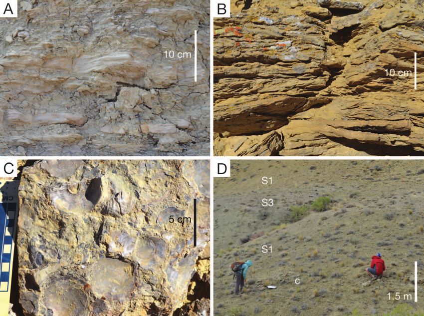
PALAIOS, 2014, v. 29, 277–294
                                                                     Research Article
                                                     DOI: http://dx.doi.org/10.2110/pal.2013.132

THE OCCURRENCE OF VERTEBRATE AND INVERTEBRATE FOSSILS IN A SEQUENCE STRATIGRAPHIC
     CONTEXT: THE JURASSIC SUNDANCE FORMATION, BIGHORN BASIN, WYOMING, U.S.A.

                                SHARON K. MCMULLEN,1 STEVEN M. HOLLAND,1 AND F. ROBIN O’KEEFE2
                   1
                    University of Georgia, Department of Geology, Athens, Georgia, 30602-2501, U.S.A., skmcmull@gmail.com, stratum@uga.edu
                     2
                      Department of Biological Sciences, Marshall University, Huntington, West Virginia 25755, U.S.A., okeefef@marshall.edu
                                                                    e-mail: stratum@uga.edu

       ABSTRACT: Previous studies of the sequence stratigraphic distribution of fossils have focused on the record of relatively abundant
       marine invertebrates. Only a handful of studies have examined how sequence stratigraphic architecture influences the occurrence
       of vertebrates, particularly large and rare tetrapods. The Jurassic Sundance Formation of the Bighorn Basin, Wyoming, USA,
       contains a rich suite of invertebrate and vertebrate fossils, including large and rare marine reptiles, and this allows the sequence
       stratigraphic controls on the distribution of these groups to be compared. The Sundance Formation consists of four depositional
       sequences, with the lower two being carbonate dominated and the upper two siliciclastic dominated. Two incised valley fills are also
       present. The presence of multiple depositional sequences and strongly erosional sequence boundaries is the likely cause of the
       complicated lithostratigraphic nomenclature of the Sundance. Invertebrates (mollusks and echinoderms) in the Sundance conform
       to well-established patterns of occurrences, including strong facies control and fossil concentrations at maximum flooding
       surfaces, in the upper portion of parasequences, and within lags overlying sequence boundaries. As expected from their rarity,
       marine reptiles (ichthyosaurs, plesiosaurs, and pliosaurs) show a weaker connection to sequence stratigraphic architecture.
       Nonetheless, they do display facies control and are found primarily in offshore mudstone, rather than shoreface and estuarine
       sandstone. They are also more common at hiatal surfaces, including a zone of concretions at the maximum flooding surface and in
       lag deposits overlying sequence boundaries. These associations suggest that sequence stratigraphic architecture may be a useful
       approach for discovery of marine vertebrates and that sequence stratigraphic context should be considered when making
       paleobiological interpretations of marine vertebrates as well as invertebrates.

                              INTRODUCTION                                      cryptocleidoid plesiosaurs (Street and O’Keefe 2010; Wilhelm and O’Keefe
                                                                                2010; O’Keefe et al. 2011) and a pliosaur (Wahl et al. 2007), as well as
   Numerous field and modeling studies over the past twenty years have
                                                                                chondrichthyans (Wahl 1998) and teleosts (Schultze and Enciso 1983).
documented the close correspondence between the fossil record and
                                                                                Invertebrates include bivalves, gastropods, belemnites, ammonoids,
sequence stratigraphic architecture, but nearly all of this research has
                                                                                serpulid worms, malacostracans, insects, ostracods, crinoids, asteroids,
focused on the rich invertebrate fossil record (Brett 1995; Holland 1995,
                                                                                and echinoids (Imlay 1948, 1957, 1980; Swain and Peterson 1952; Peterson
2000; Kidwell 1991; Patzkowsky and Holland 2012). In particular, these
                                                                                1954; Wright 1973, 1974; Herrick and Schram 1978; Blake 1981; Kvale
studies have documented sequence stratigraphic control on the occur-
                                                                                et al. 2001; Santiago-Blay et al. 2001; Palmer et al. 2004; Hunter and
rence of shell beds, as well as on changes in abundance, community
                                                                                Zonneveld 2008; Wahl 2008). This study presents a sequence stratigraphic
structure, and morphology. Far fewer studies have focused on
                                                                                interpretation of the Sundance Formation in the Bighorn Basin of north-
vertebrates, owing to their rarity; however, these few studies have also
                                                                                central Wyoming, and uses it to infer the sequence stratigraphic controls on
recognized sequence stratigraphic control on the occurrence of vertebrate
                                                                                the occurrence of vertebrate and invertebrate fossils.
fossils (Rogers and Kidwell 2000; Eberth et al. 2001; Allulee and Holland
2005; Peters et al. 2009; Loughney et al. 2011). Because marine vertebrate
fossils differ from invertebrates in size, abundance, durability, and                                        GEOLOGIC CONTEXT
composition (Peters et al. 2009), a better understanding of how these
                                                                                                         Stratigraphic Relationships
differences affect preservation and stratigraphic distribution is needed.
Understanding these controls would not only improve paleobiological                The Bathonian to Oxfordian (168–157 Ma) Sundance Formation is
and biostratigraphic interpretations (Loughney et al. 2011), it could also      approximately 100 m thick and records cyclic deposition in a mixed
facilitate the discovery of these rare fossils.                                 siliciclastic-carbonate system. The Sundance occurs over a broad region
   The Middle Jurassic Sundance Formation of the western United States          stretching from South Dakota to Idaho and from Colorado to Montana
is an ideal setting to contrast sequence stratigraphic controls on              (Parcell and Williams 2005), and it is particularly well exposed in
vertebrate and invertebrate fossils because of its diverse and abundant         hogbacks on the western slopes of the Bighorn Mountains (Fig. 1). The
fauna (Massare et al. 2014). Vertebrate fossils in this unit are dominated by   Sundance Formation overlies the Bajocian Gypsum Spring Formation
one species of ichthyosaur (Massare 2004; Wahl 2009), but also include two      and Piper Formation, which includes facies interpreted as shallow marine

Published Online: September 2014
Copyright E 2014, SEPM (Society for Sedimentary Geology)    0883-1351/14/029-277/$03.00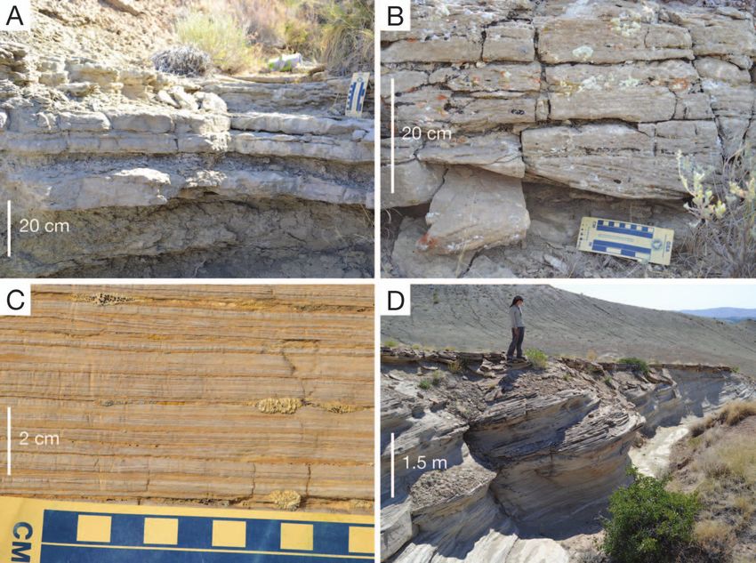
278                                                                   MCMULLEN ET AL.                                                            PALAIOS

                                                                                        FIG. 2.—Chronostratigraphic and lithostratigraphic framework of the Sun-
                                                                                     dance Formation and adjacent units in the Bighorn Basin of Wyoming, with age
                                                                                     relationships based on Imlay (1982), Calloman (1982), Kvale et al. (2001), and
                                                                                     Massare et al. (2014). Unconformities recognized by Pipiringos (1968) and
                                                                                     Pipiringos and O’Sullivan (1978) are shown at right. The durations of the J2 and J4
                                                                                     are based on Imlay (1982), but the durations of the J3 and J5 are inferred. Absolute
                                                                                     time scale is from Cohen et al. (2013).
   FIG. 1.—Location map of study area. A) United States. B) Wyoming with
outline of locality area. C) Localities in study shown with yellow dots. Outcrop
area of Jurassic strata shown in blue. Cross section A–A9 of Figure 6 indicated by
blue line.                                                                           Formation, the Windy Hill Sandstone has been included by some as a
                                                                                     member of the Morrison (Peterson 1994).
to tidal flat and sabkha (Fig. 2). The Sundance Formation is overlain by
                                                                                                         Paleogeography and Tectonic Setting
the terrestrial deposits of the Late Jurassic (148–155 Ma) Morrison
Formation (Imlay 1962, 1980; Pipiringos 1968; Kowallis et al. 1998).                    From the Bathonian to the Oxfordian, the Sundance Seaway extended
Evidence for the age of the Sundance and its members is summarized by                as shallow epeiric sea a remarkable 2000 km southward from its
Calloman (1982) and Kvale et al. (2001). Regional unconformities J1–J4,              connection to the open ocean near the southern border between the
recognized largely based on the presence of chert-pebble horizons, have              Yukon Territory and Northwest Territories of Canada (Blakey 2013).
been correlated into the Bighorn Basin, although the position of the J3              This narrow seaway was bounded to the west by a volcanic arc, to the east
unconformity is uncertain (Pipiringos 1968; Pipiringos and O’Sullivan                by the North American craton, and to the south by a prograding coastal
1978; Schmude 2000; Kvale et al. 2001). Although regional syntheses of               plain draining from the Ancestral Rockies (Fig. 3; Imlay 1957; West 1985;
the Sundance Formation and correlative units have been conducted                     Peterson 1994; Kvale et al. 2001). Recent paleogeographic reconstruc-
previously, most predate sequence stratigraphic concepts and make                    tions place Wyoming at 35u to 40uN during the Middle Jurassic (Blakey
extensive use of offshore bars and barrier islands to explain complex                2013), with a slow northward drift, although older reconstructions place
facies relationships (e.g., Brenner and Davies 1974; Rautman 1978).                  Wyoming in a more southerly position, at 22u to 33uN (e.g., Kocurek and
  The complex intertonguing of the mudstone, limestone, and sandstone                Dott 1983). Previous sedimentologic studies indicate that the Sundance
in the Sundance Formation has fostered a complex lithostratigraphic                  Formation records deposition in a variety of environments, including
nomenclature (Fig. 2; Imlay 1947, 1980; Pipiringos 1968; Wright 1973;                shallow shelf (Wright 1973; Brenner and Davies 1974; DeJarnette and
West 1985; Kvale et al. 2001). In some areas, up to seven members have               Utgaard 1986; Parcell and Williams 2005), tidal flat (Kvale et al. 2001),
been described (Pipiringos 1968). In the Bighorn Basin, the Sundance                 eolian (Stone and Vondra 1972; Kilibarda and Loope 1997), and
Formation is divided into informal upper and lower units (Imlay 1956;                estuarine (Uhlir et al. 1988).
Wright 1973; Rautman 1978). This lower Sundance includes, from                          In shape and areal dimensions, the Sundance Seaway was comparable
bottom to top, the Canyon Springs Member, the Stockade Beaver Shale,                 to the modern Red Sea, but with a widened terminus; however, the
and the Hulett Member (Imlay 1956; Schmude 2000). The upper                          shallow marine facies and the thinness of the Sundance Formation
Sundance consists primarily of the Redwater Shale, capped by the                     indicate that the Sundance Sea was far shallower. This configuration
hogback-forming Windy Hill Sandstone (Imlay 1957; Pipiringos 1968).                  in this paleogeographic setting would likely have had several signifi-
Because of its gradational contact with the overlying Morrison                       cant effects (Kocurek and Dott 1983; Peterson 1994). A 30u–40uN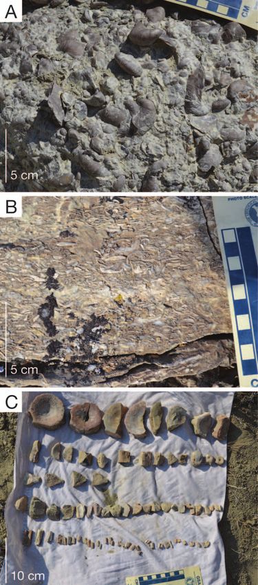
PALAIOS                            SEQUENCE STRATIGRAPHIC CONTEXT OF VERTEBRATE FOSSILS                                                              279

                                                                            having been deposited within a back-bulge basin (Fuentes et al. 2009).
                                                                            Because both types of basins are dominated by flexural subsidence, the
                                                                            differences between them are unlikely to have a significant effect on
                                                                            sequence stratigraphic architecture in the Bighorn Basin.

                                                                                                             METHODS

                                                                                                            Field Data
                                                                               Eighteen stratigraphic columns of the Sundance Formation were
                                                                            measured along an approximately 240 km northwest to southeast transect
                                                                            on the eastern flank of the Bighorn Basin (Fig. 1). Localities were
                                                                            targeted to include sites where vertebrate fossils had been found
                                                                            previously. Coordinates of columns are provided in the Appendix (also
                                                                            see online Supplementary Data File).
                                                                               At each column, beds were described for physical sedimentary
                                                                            structures, color, lithology, grain size and angularity, sorting, continuity,
                                                                            thickness, diagenetic minerals, bioturbation, ichnofossils, and body
                                                                            fossils. Twenty thin sections were prepared to characterize lithology.
                                                                            Bedding thickness is reported with the Ingram (1954) scale, siliciclastic
                                                                            rock names follow Pettijohn et al. (1987), and carbonate rock names
                                                                            follow Dunham (1962).
                                                                               A total of 185 faunal censuses of invertebrate (online Supplementary
                                                                            Data File) and vertebrate fossils were conducted in the field on bedding
                                                                            planes and weathered shale surfaces of 1–2 square meters. Faunal
                                                                            censuses were performed for 15–20 minutes each to provide a consistent
                                                                            sampling effort. Faunal abundance of each species was recorded as rare
                                                                            (1–2 specimens), common (3–10 specimens), abundant (10–20 specimens),
                                                                            or very abundant (.20 specimens). Voucher specimens were collected for
   FIG. 3.—Paleogeographic reconstruction of the Sundance Seaway, adapted   identification.
from the Late Jurassic map of North America by Blakey (2013).
                                                                                                    Quantitative Paleoecology

paleolatitude likely would have led to prevailing winds from the west,        Ordination analysis was used to identify and describe faunal
with the Bighorn Basin lying in an arid zone when at the southern end of    gradients in the fossil data, and to determine any associations between
these paleolatitudes and in a humid, temperate zone when at the northern    fossil assemblages and lithofacies. Prior to ordination, species that
end of these paleolatitudes. In this scenario, with a volcanic arc to the   occurred in only one sample and samples that contained only one
west, prevailing winds would likely have generated a rain shadow over the   species were removed, because they provide no information on faunal
region. The orientation of the seaway perpendicular to the prevailing       gradients. This culling reduced the number of samples from 53.
winds would likely have also limited the fetch for waves. The interior      Following this culling, the Wisconsin double standardization transfor-
position of the seaway behind a volcanic arc, and its position on the       mation was applied to correct for variations in sample size and species
western side of the continent would have isolated the region from most      abundance. Data were ordinated with Nonmetric Multidimensional
tropical storms. The extraordinary length of such a shallow and narrow      Scaling (NMS), using the metaMDS function in the vegan package of
seaway would likely have limited substantial tidal exchange and may have    the open source statistical software R (R Development Core Team
allowed marked departures in salinity from normal marine conditions.        2011). Because NMS is a numerical rather than analytic ordination
When the southern terminus of the seaway lay within an arid belt (cf.       technique, twenty random restarts were used to avoid solutions that
Kocurek and Dott 1983; Peterson 1994; Kvale et al. 2001), hypersaline       represent local minima (Legendre and Legendre 1998; McCune and
conditions may have occurred, but when the terminus was within a more       Grace 2002).
northerly and temperate zone, brackish conditions would have been more
likely.                                                                                                      Well Logs
   The Sundance Seaway lay in a retroarc position behind the volcanic arc      Spontaneous potential (SP) logs from boreholes were obtained from
to the west, but the cause of subsidence within this basin has been         the Wyoming Oil and Gas Conservation Commission and were used to
intensely debated (DeCelles 2004; Fuentes et al. 2009; Miall 2009).         correlate divisions of the Sundance Formation in the subsurface along the
Although the Sundance and Morrison Formations and their age                 eastern flank of the Bighorn Basin. Comparison of well logs to nearby
equivalents in Montana have been thought to have been deposited             outcrops was used to establish the interpretation of the well-log
within a retroarc foreland basin, they do not thicken westward toward the   signatures.
fold and thrust belt (Heller et al. 1986). More recently, the region has
been interpreted as the back-bulge region of a retroarc foreland basin                           SUNDANCE FACIES ASSOCIATIONS
(DeCelles and Currie 1996), but the lack of any Jurassic foredeep
sediments to the west would require the complete erosion of the entire         The Sundance Formation contains three facies associations. The lower
foredeep succession (DeCelles 2004). Recent subsidence, petrographic,       Sundance is dominated by a carbonate ramp facies association (C), and
and detrital zircon evidence from Montana suggest a Late Jurassic           the upper Sundance is dominated by the wave-dominated shelf (S) and
initiation of the Western Interior foreland basin, with the Sundance        tidal estuary (T) facies associations.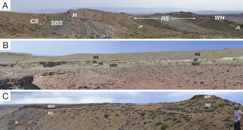
280                                                                MCMULLEN ET AL.                                                         PALAIOS

                                                    TABLE 1.— Carbonate Ramp Facies Association C.

      Facies                            Sedimentology                                       Paleontology                   Geometry and contact relationships
C1—offshore          Bioturbated gray to tan sandy terrigenous and          Highly abundant Gryphaea nebrascensis,   Tabular bodies 5–30 m thick. Always
                       calcareous mudstone to siltstone, with pelleted       with diverse microfossils, including     sharply overlain by other facies (e.g., S1,
                       texture and lacking in sedimentary structures.        benthic foraminifera, ostracods,         I2, C5, C2, C4).
                       Small (0.5 cm) pyrite nodules, minor quartz           echinoid spines, and rare neoselachian
                       silt and very fine sand.                              shark teeth. Trace fossils: Planolites.
C2—shallow           Interbedded sandy terrigenous mudstone to siltstone    Common bivalves (Myopholas, few          Tabular bodies 0.5 to 5 m thick. Sharply
 subtidal              (similar to C1) and 10–50 cm thick beds of white,     Liostrea), mostly as internal molds.     overlies maroon mudstone of Piper
                       bioturbated skeletal/peloidal/ooidal wackestone to    Common isolated crinoid columnals        Formation at base of Sundance
                       packstone. Limestone beds thicken upwards, as         (Chariocrinus). Gastropod internal       Formation. Locally gradationally
                       does number of ooids. Bioturbation generally          molds locally common (e.g., Lyosoma),    overlain by Facies C3, but more typically
                       intense and ripple lamination is rare. Fine to        as are udoteacean algae, foraminifera,   sharply overlain by Facies C1.
                       very fine quartz and chert grains common              and ostracods. Spongiostromate pisoidal
                       increase in abundance upwards, as do ooids.           and oncoidal coatings common.
                       Includes 20–30 cm intervals of wave-rippled fine
                       carbonate sand.
C3—ooid shoal        Oolitic quartzose grainstone, often bearing highly     Bivalves, crinoid ossicles, foraminifera,   Tabular bodies approximately 1–2 m thick.
                       fragmented skeletal grains. Ooids commonly             and rare gastropods.                       Locally grades upwards rapidly into
                       micritized. Skeletal grains and pyrite nodules                                                    facies C5.
                       (0.5 cm) locally present. Quartz silt to lower
                       very fine sand locally common. Trough cross-
                       stratification, ripple-laminated, and planar
                       laminated. Internal erosional surfaces with up to
                       2 m of relief, overlain by upward-thinning beds.
C4—lagoonal          Planar-laminated gray lime mudstone, locally with      Insects, ostracods, and fish have been      Tabular bodies 5–12 m thick, restricted to
                       flaser to lenticular lamination. Contains abundant     reported (e.g., DeJarnette and             northernmost portion of study area.
                       fine-grained quartz sand.                              Utgaard 1986), but generally lacks         Sharply overlies Facies C1 and is sharply
                                                                              fossils.                                   overlain by Facies S1 and S2.
C5—eolian            Oolitic quartzose grainstone, with large-scale         Highly abraded minute bivalve               Lenticular bodies up to 12 m thick. Sharply
                      (. 3 m) tabular foresets and inversely graded           fragments.                                 overlain by Facies S1. Locally erosionally
                      pin-stripe laminae. Meniscus cement common.                                                        overlain by Facies I2 and I3.
                      Highly abraded and fragmented skeletal grains,
                      mostly bivalves, commonly neomorphosed.
                      Locally abundant grains of quartz silt to lower
                      very fine sand. Raindrop impressions locally
                      preserved. Uppermost surface locally bears
                      wave ripples.

                 Carbonate Ramp Facies Association C                               ripple lamination, and planar lamination indicates frequent reworking by
                                                                                   currents and waves (Fig. 4B). A Skolithos ichnofacies also supports
  The carbonate ramp facies association consists of five facies that               shallow-water deposition. Quartz grains likely represent eolian input, and
represent offshore (C1), shallow subtidal (C2), ooid shoal (C3), lagoonal          an increase in these grains to the south suggests a source in that direction.
(C4), and eolian (C5) environments (descriptions summarized in Table 1).           Locally, the top of this facies is wave rippled and bears tridactyl dinosaur
  Facies C1 records deposition on the distal portion of a carbonate ramp,          footprints, indicating deposition near the shoreline (Kvale et al. 2001).
based on its marine fauna, uniformly fine grain size, dominance of                 Facies C3 is present at the tops of meter-scale cycles in the Canyon
bioturbation over physical sedimentary structures, regional lateral extent,        Springs Member, and it also comprises part of the lower Hulett Member.
and its gradational contact with Facies C2. Facies C1 is represented                  Facies C4 records deposition in a quiet-water hypersaline lagoon
primarily by the Stockade Beaver Shale, but is also present in the lower           behind shoals, as indicated by its fine grain size, papery planar lamination
portion of the Canyon Springs Member.                                              (Fig. 4C), and lack of burrows. This facies is reported to contain a sparse
  Facies C2 was deposited on the inner portion of a carbonate ramp, one            fauna of well-preserved insects, fish (Pholidophorus americanus), and
characterized by relatively quiet water, as indicated by the dominance of          ostracods (Imlay 1965; DeJarnette and Utgaard 1986; Kilibarda and
bioturbation over physical sedimentary structures. Facies C2 is distin-            Loope 1997; Santiago-Blay et al. 2001), although this fauna of insects,
guished from Facies C1 by the presence of beds of limestone encased in             fish, and ostracods was not encountered in this study. Quartz grains are
mudstone (Fig. 4A), which may indicate storms, although specific                   interpreted as eolian in origin. Facies C4 comprises the middle Hulett
evidence of storm-generated waves or currents is lacking. The abundance            Member (of DeJarnette and Utgaard 1986) and is limited to the northern
of crinoid columnals, accompanied by common bivalves and gastropods,               portion of the study area (Schmude 2000).
suggests relatively normal marine salinity, and the presence of codiacean             Facies C5 represents carbonate eolian dunes, as indicated by inversely
algae suggests clear water free of suspended sediment. Facies C2                   graded pinstripe laminae, tabular foresets several meters tall (Fig. 4D),
comprises most of the Canyon Springs Member, and limited portions                  meniscus vadose cement, and raindrop impressions (Kilibarda and Loope
of the lower Hulett Member (of DeJarnette and Utgaard 1986).                       1997). Where Facies C5 overlies Facies C3, abraded bivalve fragments are
  Facies C3 is transitional from Facies C2 and records deposition on               locally present at the toes of some foresets. In a few outcrops, erosional
shoals on the innermost portion of a carbonate ramp (Stone and Vondra              surfaces with up to 2 m relief and overlain by an upward-thinning series
1972). The abundance of ooids, commonly micritized, suggests well-lit              of beds likely represent tidal channels. Wave ripples at the top of this
shallow-water conditions, and the abundance of trough cross-bedding,               facies likely record reworking during transgression (Kilibarda and Loope
PALAIOS SEQUENCE STRATIGRAPHIC CONTEXT OF VERTEBRATE FOSSILS 281
FIG. 4.—Carbonate ramp facies association. A) Facies C2, interpreted as shallow subtidal with beds of bioturbated skeletal/ooidal/peloidal wackestone and packstone
interbedded with calcareous siliciclastic mudstone, and overlying Facies C1 (offshore). B) Facies C3, interpreted as ooid shoal, with cross-bedded ooid grainstone. C)
Facies C4 (lagoonal), illustrating paper-thin planar laminae of lime mudstone. D) Facies C5 (eolian), displaying large-scale foresets, truncated at top by wave-ripple–
laminated beds.
1997). Facies C5 comprises most of the lower Hulett Member in the ichnofacies, and widespread geographic extent. Thin sandy to shelly beds
central portion of the study area. likely reflect storm beds (Fig. 5A, Brenner and Davies 1973; Specht and
Overall the carbonate ramp facies association indicates deposition on a Brenner 1979), but they are infrequent, and clear evidence of typical storm-
homoclinal ramp, much like those reported from other Jurassic settings generated features such as hummocky cross-stratification is lacking,
(Burchette and Wright 1992; Aurell et al. 1995; Azeredo 1998). The suggesting deposition on a low-energy coast (Clifton 2006). Facies S1
abundance of ooids and the presence of large eolian dunes suggests contains up to two regionally traceable horizons of calcite-cemented
semiarid to arid conditions during the Bathonian and Callovian. concretions, the lower of which is abundantly fossiliferous, including the
Paleocurrents on wave ripples indicate flow to the north-northwest and ammonite Cardioceras. These concretions are similar to those reported to
south-southeast, corresponding to a shoreline oriented west-southwest the east from Natrona and Carbon counties by Andersson (1979).
and east-northeast (Stone and Vondra 1972). Paleocurrent measurements Facies S2 gradationally overlies Facies S1 and records deposition in a
on eolian foresets are more variable, but have dominant modes to the shoreface setting. The presence of pervasive wave-ripple and current-
northwest and south-southwest (Stone and Vondra 1972). ripple lamination (Fig. 5B) rather than hummocky cross-stratification
and trough cross-bedding supports the interpretation of a low-energy
Wave-Dominated Shelf Facies Association S setting (Raaf and van Gelder 1977; Clifton 2006). The trace fossil
The wave-dominated shelf facies association consists of three facies association indicates a Skolithos ichnofacies, additional evidence of a
that represent offshore (S1) and shoreface (S2) environments, as well as shallow-water setting.
shell beds (S3) that occur at parasequence tops (Table 2). These three Facies S3 also gradationally overlies Facies S1 and is interpreted as
facies comprise the Redwater Shale of the upper Sundance. recording upward shallowing and the formation of a shell bed (Kidwell
Facies S1 represents relatively deep-water deposition on a siliciclastic 1991). Two such shell beds are present (Fig. 5C, D), and they are
shelf, as indicated by the fine grain size, marine fauna, Cruziana regionally traceable (Fig. 6). The lower shell bed is overwhelmingly282 MCMULLEN ET AL. PALAIOS
TABLE 2.— Wave-dominated Siliciclastic Shelf Facies Association S.
Facies Sedimentology Paleontology Geometry and contact relationships
S1—offshore Olive gray glauconitic and bioturbated mudstone Belemnites (Pachyteuthis) typically highly Tabular units up to 65 m thick.
to siltstone grading upwards into tan sandy abundant. Gastropods and ammonites Gradationally overlain by Facies S2, and
mudstone and sandy siltstone. Bivalve fragments (Cardioceras) locally common, usually in sharply overlain by several facies of
present locally and commonly neomorphosed. concretions with other bivalves (Astarte, estuarine association T.
Shell beds 2–20 cm thick locally developed and Pleuromya, Vaugonia). Rare echinoids.
dominantly composed of bivalves. Up to two Ostracods. Articulated skeletons and isolated
horizons of light gray or rusty carbonate bones of plesiosaurs (Pantosaurus, Tatenectes)
concretions, with lower horizon containing and ichthyosaurs (Ophthalmosaurus). Trace
common trace and body fossils. fossils include Planolites and Rhizocorallium,
mostly preserved within concretions.
S2—shoreface Tan, fine-grained to very fine-grained, Rare poorly preserved internal molds of bivalves. Tabular units up to 10 m, generally thinner,
sublitharenite to quartz arenite, often Rare bone, including the plesiosaur Tatenectes. and usually truncated by an erosional
argillaceous and interbedded with silty Trace fossils common, including Planolites, surface overlain by facies of the estuarine
mudstone to siltstone. Sandstone beds 2–10 cm Chondrites, Skolithos, and Schaubcylindrichnus. association T.
thick, increasing in number and thickness up-
section, and containing common wave-ripple
lamination, planar lamination, and current-
ripple lamination. Glauconite is common
as peloids, as are grains of black chert. Sand
cemented with carbonate, with minor pyrite
and goethite.
S3—shell beds Highly shelly very fine-grained sublitharenite to Bivalves (Liostrea or Camptonectes) abundant, Tabular units, generally less than 1 m thick.
quartz arenite in beds 2–30 cm thick, separated often in nearly monospecific accumulations. Gradational contact with underlying
by thin mudstone partings and lacking Rare to uncommon crinoid columnals facies S1, but sharp contact with
sedimentary structures. Glauconite is common (Isocrinus) overlying facies S1.
as peloids. Shells are densely packed in beds
that thicken upwards. Preservation of shells
varies widely, from nearly pristine articulated
shells, to isolated valves, to highly fragmented
shells ranging down to sand-sized grains.
Individual beds have crude normal grading,
but lack other sedimentary structures.
composed of the oyster Liostrea, and the upper shell bed is dominated by of the Sundance Formation, and the second comprises the entire Windy
the scallop Camptonectes. Similar Camptonectes beds occur in upper Hill Sandstone that caps the Sundance Formation (Uhlir et al. 1988).
Oxfordian deposits of Milne Land, East Greenland and have been Facies T1 represents channel-bottom deposits, based on the abundance
interpreted as offshore storm events that reworked accumulations of of shells, mudstone intraclasts, chert pebbles, and the coarsest grain size
Camptonectes shells (Fürsich and Heinberge 1983). Individual beds within of sand present in the Sundance Formation (Fig. 7A, B; Uhlir et al. 1988).
Facies S3 also likely have a storm origin (Specht and Brenner 1979). Lateral accretion surfaces reflect the migration of adjacent bars, and
Overall, the wave-dominated shelf facies association reflects deposi- trough cross-stratification indicates the presence of dunes. Bivalves, rare
tion on a relatively protected, low-energy siliciclastic margin. Low- echinoderms, and rare belemnites indicate a marine influence. The local
energy wave-dominated coasts differ from high-energy coasts in that dominance of Liostrea suggests brackish conditions, whereas the local
low-energy systems generally have thinner deposits, their maximum dominance of Ceratomya indicates areas of near-normal marine salinity
grain size is typically fine grained, and their deposits lack upper flow (Fürsich et al. 1995). Facies T1 typically overlies a highly erosional
regime sedimentary structures (Clifton 2006). Modern low-energy surface at the base of the Windy Hill Sandstone (discussed below), but
analogs are present in southeastern Spain and along the southeastern can also occur repeatedly within individual outcrops of the Windy Hill.
U.S. coast (Howard et al. 1972; Clifton 2006). Studies from the Facies T2 and T3 represent tidal bars, based on their typical occurrence
mesotidal coast of the southeastern United States indicate that the above Facies T1 and abundant tidal features including tidal bundling,
largest grain size seen in low-energy coasts is typically fine-grained sand clay drapes, reactivation surfaces, and reversing paleocurrent directions
because wave-generated flows are too weak to transport coarser (Fig. 7C; Uhlir et al. 1988). Facies T2 is characterized by trough cross-
sediment (Howard et al. 1972). No foreshore sediments were recognized stratification, indicating dunes, which is variably bioturbated with a
in the Sundance Formation, reflecting relatively weak waves, but Skolithos ichnofacies. Planar lamination within Facies T2 may record
possibly also because they were eroded during the formation of the episodically elevated shear stress, or it may indicate foreshore settings
overlying sequence boundary. within the outer portions of the estuary (Uhlir et al. 1988). Facies T3 has
distinctive sigmoidal cross-stratification (Fig. 7D), formed by neap-spring
Tidal Estuary Facies Association T tidal variations and common in the open, sandy portions of estuaries
(Kreisa and Moiola 1986; Shanley et al. 1992).
The tidal estuary facies association consists of four facies interpreted to Facies T4 records deposition on tidal sand flats, based on its typical
have been deposited in tidal channel (T1), tidal bar (T2 and T3), and tidal association overlying Facies T2 and T3, its finer grain size than the other
sand flat (T4) environments (Table 3). The tidal estuary facies association facies tidal estuary association, and the abundance of wave-ripple and
is present in two intervals of the Sundance Formation. The first comprises current-ripple lamination (Fig. 7E). Common climbing ripples record
the upper Hulett Member (of DeJarnette and Utgaard 1986) in the middle local rapid deposition at the edges of the sand flats. Both inside andPALAIOS SEQUENCE STRATIGRAPHIC CONTEXT OF VERTEBRATE FOSSILS 283
FIG. 5.—Wave-dominated siliciclastic shelf facies association. A) Facies S1 (offshore), with a few very thin beds of rippled sand. B) Facies S2 (shoreface), displaying
rippled very fine sandstone. C) Bedding-plane view of Facies S3 with abundant valves of the scallop Camptonectes. D) Facies S3, encased in Facies S1, illustrating minimal
differences in weathering of these facies. c 5 horizon of fossiliferous concretions.
outside of the Bighorn Basin, rippled sand facies within the Windy Hill Sequence J2
preserve pterosaur tracks (e.g., Logue 1977; Lockley and Wright 2003;
Harris and Lacovara 2004; Connely 2006). Sequence J2 is represented by Canyon Springs Member and Stockade
Elements of the tidal estuary facies association are typically arrayed in Beaver Shale. The basal sequence boundary is marked by a sharp contact
fining-upward successions, with Facies T1 (tidal channel) at the base, with structureless red mudstone of the Gypsum Spring and Piper
overlain by Facies T2 and T3 (tidal bar), and capped by Facies T4 (tidal formations. The contact is locally mantled by chert pebbles (Pipiringos
sand flat). Most successions preserve only a portion of this sequence, owing 1968). At Ten Sleep, for example, the contact is overlain by a 30 cm
to channel migration. Paleocurrent measurements on large-scale foresets conglomerate of well-rounded, poorly sorted chert pebbles, typically with
within this facies association indicate northwest-southeast bimodal tidal diameters of 1–2 cm, but up to 10–13 cm. In most places, chert pebbles
flow within sandstone facies (T2 and T3), and east-west lateral channel are scarce.
migration within the coquina channel lag (T1) facies (Uhlir et al. 1988). The lower part of the J2 sequence consists of 2–3 carbonate
parasequences. To the north, these are composed of facies deposited in a
SUNDANCE SEQUENCE STRATIGRAPHY
shallow subtidal environment (C2). Southward, these parasequences have
thicker caps of bioturbated skeletal to oolitic wackestone and packstone,
The Sundance Formation contains four depositional sequences which pass into oolitic facies (C3) farther to the south. This regional
(Figs. 6, 8A). The first two sequences are built from the carbonate ramp transition suggests that the southern end of the transect is a relatively
facies association. The third sequence is primarily composed of the tidal shallower water setting than the northern end. The tops of these
estuary and wave-dominated shelf facies associations, and the fourth is parasequences are commonly wave rippled. Some comprise firmgrounds
entirely tidal estuary facies association. The sequence-bounding uncon- or hardgrounds, with microbial mats, casts of salt crystals, Diplocraterion
formities correspond to previously recognized regional unconformities and Rhizocorallium. At least one of these parasequence tops bears abundant
(Pipiringos 1968; Pipiringos and O’Sullivan 1978). tridactyl dinosaur tracks attributed to a small theropod (Kvale et al. 2001,284 MCMULLEN ET AL. PALAIOS
FIG. 6.—Stratigraphic cross section of the Sundance Formation on the east flank of the Bighorn Basin, Wyoming.
2004; Mickelson et al. 2006; Clark and Brett-Surman 2008). Stacking Shale. The Stockade Beaver Shale may represent parts of the transgressive
patterns in these parasequences appear to be aggradational: they all contain and highstand systems tracts (HST), but it lacks any evidence of facies
the same facies, with no obvious regionally consistent upward trend in facies variation or an obvious maximum flooding surface or zone.
composition or thickness. These carbonate strata are sharply overlain by
mudstone facies (C1) of the Stockade Beaver Shale, which contains Sequence J3
extraordinarily abundant, largely disarticulated valves of Gryphaea
nebrascensis. With the aggradational stacking of shallow-water carbonates, Sequence J3 is represented by a portion of the Hulett Member,
the Canyon Springs is interpreted as the transgressive systems tract (TST), specifically the lower and middle carbonate members of DeJarnette and
with a major flooding surface at its upper contact with the Stockade Beaver Utgaard (1986). The basal sequence boundary is marked by a sharpPALAIOS SEQUENCE STRATIGRAPHIC CONTEXT OF VERTEBRATE FOSSILS 285
FIG. 6.—Continued.
contact of shallow-water carbonate facies on the offshore mudstone of the Sheep Mountain (Fig. 6), basal facies of the Hulett deposited in a
Stockade Beaver Shale (Fig. 8B). To the north, these are facies deposited shallow subtidal environment (C2) are gradationally overlain by facies
primarily in lagoonal (C4) and sometimes ooid shoal (C3) environments. deposited in an ooid shoal environment (C3), capped by facies deposited
Facies deposited in an eolian setting (C5) typically lie above this contact in in an eolian environment (C5). Whether this represents a single
the central portion of the transect, although locally facies deposited in a parasequence or progradational stacking is unclear. Depositionally
shallow subtidal environment (C2) do. The uppermost mudstone of the downdip, at Bighorn NRA (Fig. 6), basal ooid facies (C5) are overlain
Stockade Beaver Shale is commonly stained red beneath this unconformity. by facies deposited in a lagoonal setting (C4), also suggesting upward
The base of the Hulett Member was thought by Pipiringos and O’Sullivan shallowing.
(1978) to be the J3 unconformity in the Bighorn Basin. The J3
unconformity is truncated by the J4 unconformity in the southernmost Sequence J4
part of the study area, suggesting uplift on the Sheridan Arch (Pipiringos
and O’Sullivan 1978; Schmude 2000). Sequence J4 consists of the upper Hulett Member (of DeJarnette and
Little of the J3 sequence is preserved, and most exposures display only Utgaard 1986) and the Redwater Shale. Stratigraphic relationships within
a single facies, making assignment to any systems tract uncertain. At the J4 sequence are often difficult to recognize in the field, owing to286 MCMULLEN ET AL. PALAIOS
TABLE 3.— Tidal Estuary Facies Association T.
Facies Sedimentology Paleontology Geometry and contact relationships
T1—tidal channel Medium-grained sublitharenite to litharenite Abundant bivalves, primarily Liostrea Lens-shaped with highly erosional base, with up to
with abundant and typically densely packed and Ceratomya, but also Tancredia, 10 m of relief visible at a single outcrop. Overlain
broken (, 1 cm across) and abraded bivalves, Camptonectes, Quenstedtia. Crinoid by facies of the estuarine association (most often
with less common wood and bone. Grains of columnals and belemnites locally T2 or T3), or in some cases, presumed Morrison
glauconite and black chert are common. present. No trace fossils observed. Formation, although such contacts are usually
Coarse calcite cement. Hematite-cemented poorly exposed on steep dip slopes.
sandstone rip-up clasts and mudstone rip-up
clasts (to 3 cm) locally present. Trough cross
bedding common (20–50 cm sets), and tabular
cross beds up to 1.5 thick locally developed,
as are sets of lateral accretion surfaces.
T2—tidal bar Very fine-grained to medium-grained Rare to locally common bivalves, Lens-shaped bodies up to several meters thick.
sublitharenite, generally with trough cross- typically small Liostrea. Trace fossils Commonly overlies Facies T1 and overlain by
bedding in 20–60 cm sets, but locally highly include Diplocraterion, Skolithos, and Facies T4, but can have sharp contacts with any
bioturbated. Beds of planar lamination are Schaubcylindrichnus. facies of the estuarine association T.
also present. Calcite-cemented, with sparse
micritized skeletal grains. Mudstone rip-up
clasts locally present. Clay drapes on foresets
are common, as are reactivation surfaces,
herringbone cross-stratification, and tidal
bundling of foresets.
T3—tidal bar Similar to Facies T2, but with distinctive Lacks body and trace fossils. Lens-shaped bodies up to a few meters thick.
tidally bundled sigmoidal cross-bedding Generally associated with Facies T2 and
in sets 40–80 cm thick. Calcite cemented. overlain by facies T4.
T4—tidal sand flat Very fine-grained to fine-grained sublitharenite Rare bivalves, primarily in thin Lens-shaped bodies up to 7 m thick. Commonly
in beds 2–25 cm thick. Pervasively ripple- shell beds. overlies Facies T2 and T3, but sharply overlain
laminated, primarily current-generated, by other facies of the estuarine association.
but also some wave-generated forms.
Climbing ripple lamination is common.
Locally with 0.5–2 cm argillaceous interbeds
and 15–20 cm beds of shelly rippled sand.
Rare coal laminae. Calcite cemented.
widespread slumping and deep weathering. Because the thickness of the Throughout the region, the Hulett is sharply overlain by offshore
Redwater Shale is relatively uniform in well-log data (Fig. 9), pronounced mudstone (S1) of the belemnite-rich Redwater Shale, marking a
variations in outcrop thicknesses of the Redwater Shale over relatively prominent and major flooding surface. At some localities, the base of the
short distances (e.g., Little Sheep Mountain C and D, Fig. 6) are Redwater has a 50 cm glauconitic and sandy cross-bedded oolitic to shelly
attributed to slumping and duplicated sections. Likewise, shelly horizons grainstone. In other localities, the base of the Redwater is marked by up to
within the Redwater Shale have consistent positions in well logs (Fig. 9), 30 cm of current-ripped to wave-rippled pyritic quartz arenite, which in a
and their stronger variation in position within outcrops (Fig. 6) is also few cases overlies the oolitic to shelly grainstone. Wave-ripple crests on this
attributed to slumping. bed are oriented ENE-WSW, consistent with a roughly east-west oriented
The basal sequence boundary of the J4 sequence is an erosional surface, shoreline. In other places, the base of the Redwater has a 3–15-cm-thick
with up to 10 m of relief visible at a single outcrop (Fig. 8B), with megarippled shell bed. The transgressive surface is placed underneath these
erosional lows filled with sandstone of the upper Hulett (of DeJarnette distinctive beds, which are interpreted to reflect various forms of
and Utgaard 1986). This erosional surface also displays regional stratigraphic condensation during flooding into offshore settings.
truncation, progressively removing the lower and middle Hulett The Redwater Shale contains several weakly developed parasequences,
carbonates to the south, followed by the Stockade Beaver Shale, and defined primarily by evidence of stratigraphic condensation rather than
the upper portion of the Canyon Springs Member (Fig. 6). Where the facies changes. The first of these flooding surfaces is placed at a horizon
Stockade Beaver Shale underlies the J4 unconformity, the upper meter is of rusty carbonate concretions up to half a meter across (Fig. 5D). These
stained red (e.g., Red Gulch, Fig. 6). Where the Hulett eolianites underlie concretions preserve Rhizocorallium and Thalassinoides traces, suggesting
this surface, the upper half-meter is chalky. In some places, no incision is firmground conditions. These concretions can be richly fossiliferous with
present, and the Redwater Shale rests directly on the lower or middle abundant bivalves, and rare crinoids, belemnites, and ammonoids, some
Hulett carbonates (e.g., Bighorn NRA, Sheep Mountain, Fig. 6). The with preserved color patterns. Some of the concretions preserve
upper Hulett, which fills erosional lows along this sequence boundary, ichthyosaur bone and decapods (Wahl 2008).
consists of facies deposited in tidal bar (T2) and tidal sand flat (T4) The second and third flooding surfaces are marked by shell beds
environments, and it is interpreted as the lowstand systems tract (LST), (Facies S3; Figs. 5D, 8A), the first having abundant oysters (Liostrea
although it may represent initial TST deposits. Chert pebbles are known strigilecula), and the second having abundant scallops (Camptonectes
from the base of the Redwater Shale and have been used to infer the bellistriatus). A second horizon of concretions—white and sparsely
presence of the J4 unconformity (Pipiringos 1968; Pipiringos and fossiliferous—occurs above the scallop shell bed. These surfaces are
O’Sullivan 1978). We suggest that the J4 unconformity lies at the base regionally traceable on spontaneous potential well logs (Fig. 9), and their
of the Redwater Shale where the upper Hulett is absent, and that it lies well log signatures may reflect variations in cementation. Well-log
underneath the upper Hulett where it is present. expression suggests that the lowest of these flooding surfaces (the rusty,PALAIOS SEQUENCE STRATIGRAPHIC CONTEXT OF VERTEBRATE FOSSILS 287 FIG. 7.—Tidal estuary facies association. A) Facies T1 (tidal channel), showing large scale foresets developed in coarse shelly sand. B) Facies T1, with large sandstone rip-up clast in a matrix of coarse sand and shells. C) Facies T2 (tidal bar), with opposing paleocurrent directions. D) Facies T3 (tidal bar), with sigmoidal cross-bedding. E) Facies T4 (tidal sand flat), with climbing ripples of very fine sand. F) Upward-fining cycles composed of Facies T1 (tidal channel), T2 (tidal bar), and T3 (tidal sand flat). Basal erosional surfaces indicated with dashed lines; lower surface is the J5 sequence boundary. S1 5 Redwater Shale.
288                                                                    MCMULLEN ET AL.                                                            PALAIOS

  FIG. 8.—Sequence stratigraphic architecture. A) Overview of the Sundance Formation at Camp Skeeter. CS 5 Canyon Springs Member; SBS 5 Stockade Beaver
Shale; H 5 Hulett Member; RS 5 Redwater Shale; WH 5 Windy Hill. Dashed lines: tops of shell-bed–capped parasequences. J3–J5 sequence boundaries indicated. B)
Incised valley fill at J4 unconformity at Pantosaurus locality. Abbreviations as in part A, with Hl 5 lower Hulett, and Hu 5 upper Hulett. Long-dashed line is J3 sequence
boundary, solid line is J4 sequence boundary displaying truncation of underlying sequence, and short-dashed line is major flooding surface at the base of the Redwater
Shale. C) J5 sequence boundary (solid line) east of the Red Gulch Dinosaur Trackway, showing truncation of underlying shoreface-capped parasequences of the
Redwater Shale, with flooding surfaces indicated by dashed lines. S 5 slumped block. Abbreviations as in part A.

fossiliferous concretions) is the most distal, making it the maximum                  basal beds often contain rip-up clasts of mudstone and cemented
flooding surface. The Redwater Shale beneath this concretion horizon                  sandstone of the Redwater Shale (Fig. 7B), as well as chert pebbles,
locally contains thin sandy and shelly storm beds (Brenner and Davies                 wood, and bone fragments. In some places, distinct fining-upward
1973), which are largely absent above the concretions, consistent with the            cycles that record deposition in tidal channel (T1), tidal bar (T2 and
concretion horizon marking the maximum flooding surface. In the                       T3), and tidal sand flat (T3) environments are developed (Fig. 7F). In
uppermost Redwater, facies deposited in an offshore environment (S1)                  most places, transitions between these facies are abrupt and
pass upward into facies deposited in the shoreface (S2), consistent with              unpredictable. Furthermore, individual facies bodies often cannot be
overall progradational stacking in the HST.                                           traced laterally for more than a few tens to hundreds of meters. The
                                                                                      shelly beds have been previously interpreted as shell sand ridges
                                  Sequence J5                                         (Brenner et al. 1985), but this is inconsistent with the deeply incised
                                                                                      basal surface, and presence of facies typical of tidally influenced
   Sequence J5 consists of the Windy Hill Sandstone and likely some                   estuarine systems.
portion of the overlying Morrison Formation. The J5 sequence boundary                    The contact with the overlying Morrison was not observed in the study
is a highly erosional surface (Fig. 8C) and has been recognized previously            area, as it is generally covered on the dip slope formed by the Windy Hill
as a regional unconformity (Pipiringos 1968; Pipiringos and O’Sullivan                hogback. Where others have seen the transition, both within and beyond
1978; Ahlbrandt and Fox 1997). It commonly displays meters, and in                    the Bighorn Basin (e.g., Johnson 1992; Peterson 1994), they have
some cases, more than 10 meters of relief within a single outcrop. Where              described it as gradational, suggesting that the tidal estuarine facies
the depth of erosion is great, facies deposited in the shoreface (S2) are
                                                                                      association of the Windy Hill may pass upward into a tidal delta facies
missing from the top of the Redwater, and the Windy Hill rests directly
                                                                                      association, followed by coastal plain deposits of the Morrison. Because
on the mudstone (S1) of the Redwater.
                                                                                      the estuarine deposits of the Windy Hill were never overstepped by
   The tidal estuary deposits of the Windy Hill Sandstone overlie the J5              marine facies, it is not possible to identify a transgressive surface, and the
sequence boundary throughout the study area. The thickness of the Windy               systems tract that the Windy Hill represents is uncertain.
Hill directly reflects the depth of erosion, and this thickness varies
markedly over short distances. These thickness variations affect the
development of the erosional hogback supported by the Windy Hill. The                                         SUNDANCE FOSSIL DISTRIBUTION
hogback is prominent where the J5 unconformity is deeply incised and it is
                                                                                                                     Invertebrate Fossils
minor to absent where little erosion has occurred on the J5 unconformity.
   In most places, the basal beds of the Windy Hill are composed of                      The occurrence of invertebrate fossils is strongly controlled by overall
shelly and coarse-grained facies interpreted as tidal channel (T1). These             stratigraphic position and depositional environment, and this is best
PALAIOS SEQUENCE STRATIGRAPHIC CONTEXT OF VERTEBRATE FOSSILS 289 FIG. 9.—Correlation of spontaneous potential well logs and selected outcrops along the east flank of the Bighorn Basin, Wyoming. Comparison of well logs to nearby outcrops indicates that positive (rightward) excursions on the logs correspond to porous units such as sands and shell beds, whereas negative (leftward) excursions correspond to intervals of mudstone. Red lines indicate sequence-bounding unconformities. Gray lines indicate flooding surfaces and, within the J4 sequence, the upper and lower contacts of shell beds. Resistivity logs in this area generally show little variation through the Sundance Formation and are not displayed. shown by nonmetric multidimensional scaling (NMS ordination) of field present at the lower concretion horizon in the northern part of the field censuses (Fig. 10). area (e.g., Little Sheep Mountain). These concretions contain a diverse Samples from the upper and lower Sundance cleanly separate, assemblage of bivalves (Astarte, Liostrea, Pleuromya, Vaugonia), belem- primarily along NMS axis 1, with lower Sundance samples having nites (Pachyteuthis), ammonoids (Cardioceras), and crinoids (Isocrinus). typically larger scores than upper Sundance samples (Fig. 10A). Lower Preservation is generally good with minimal breakage and abrasion, with Sundance samples are usually dominated by some combination of the common articulation of bivalves. The second association occurs at a oyster Gryphaea nebrascensis, the crinoid Chariocrinus, and indeterminate shelly horizon at the top of a parasequence. This interval is dominated bivalves and gastropods, whereas upper Sundance samples contain the almost exclusively by the oyster Liostrea strigilecula. These shells are oyster Liostrea strigilecula, belemnites, the crinoid Isocrinus, the nearly always disarticulated, with moderate amounts of breakage and ammonoid Cardioceras, and an array of bivalves, including Astarte, abrasion. The abundance of shells varies laterally in an outcrop, giving Vaugonia, Tancredia, and Myopholas (Fig. 10B). The faunal distinctive- the appearance of isolated shoals, but areas between these concentrations ness of the lower and upper Sundance likely reflects the overall also contain shells and well-log tracing indicates that this horizon is depositional setting of the two units, with the lower Sundance being regionally persistent. The third association occurs in a shell bed at a carbonate dominated and the upper Sundance being siliciclastic parasequence near the top of the Redwater Shale, and it contains dense dominated. The faunal distinctiveness may also reflect a substantial accumulations of the scallop Camptonectes bellistriatus (Fig. 5C). These difference in age between the lower and upper Sundance. Except where show a wide range of preservation, including beds of articulated and the upper Hulett incised valley fill is present, the boundary between the whole valves to beds of highly fragmented shells. lower and upper Sundance corresponds the J3 unconformity. This Finally, tidal estuarine deposits in the Windy Hill Sandstone have unconformity is thought to represent the longest hiatus within the localized, monospecific accumulations of Ceratomya (Fig. 11B), as well Sundance (Imlay 1980), spanning the middle and upper Callovian, and as accumulations dominated by Liostrea strigilecula, with the bivalves representing up to 2 myr. Tancredia, Camptonectes, and Quenstedtia. Most shells are disarticulated, Faunal assemblages from the lower Sundance differ among lithofacies. fragmented, and abraded, suggesting substantial local reworking. In Canyon Springs facies that record shallow subtidal deposition (C2) addition are rare specimens of belemnites and crinoids that are so highly commonly contain abundant bivalves, common crinoid columnals abraded and fragmented that they are likely reworked from the (Chariocrinus), and rare gastropods. Bivalves are typically preserved as underlying Redwater Shale. molds, making identification difficult, with the exception of Myopholas. The available ooid shoal samples tend to lack Myopholas and gastropods, Vertebrate Fossils but they contain common fragmentary bivalve molds that are rarely identifiable. The Stockade Beaver Shale is distinct from both facies of the Marine reptiles are found in the Redwater Shale and Windy Hill Canyon Springs because it contains a virtually monospecific fauna of Sandstone, where they occur along flooding surfaces, along sequence extraordinarily abundant Gryphaea nebrascensis (Fig. 11A). Such samples boundaries, and within facies recording offshore (S1) and shoreface (S2) are not shown on the ordination because monospecific samples tend to deposition. distort relationships among samples in ordinations and are culled before Vertebrate fossils are found along the maximum flooding surface in the analysis. Redwater Shale in the northern part of the study area. These fossils are Within the upper Sundance, samples also segregate by lithofacies often preserved in fine-grained concretions, with good surface detail, both (Fig. 10C), with some overlap. Mudstone (S1) of the Redwater Shale is as isolated bones and partially disarticulated but associated remains generally dominated by nearly monospecific accumulations of the (Fig. 10B, C). The assemblage is limited, and consists of one ichthyosaur belemnite Pachyteuthis densus. More rarely, these are associated with species (Ophthalmosaurus natans) and one plesiosaur species (Pantosaurus sparse small shells of Liostrea strigilecula and Camptonectes bellistriatus. striatus; Wahl et al. 2007). Remarkably, one of these plesiosaur specimens Near flooding surfaces, three distinct associations form within the recently discovered at the Pantosaurus site (Fig. 6) has an ichthyosaur offshore of the Redwater Shale. The lowermost of these associations is embryo in its stomach contents (O’Keefe et al. 2009).
290   MCMULLEN ET AL.                                               PALAIOS

                 Vertebrate fossils are also found in association with J5 sequence
              boundary, where isolated highly abraded bone fragments are found in
              tidal channel deposits (T1) that immediately overlie the sequence
              boundary. The preservation of these fragments is so poor that neither
              the taxon nor the element can generally be determined. Given its state of
              preservation, some or all of this material may represent material
              reworked from the erosion of the underlying Redwater Shale.
                 Some vertebrate fossils are found in facies recording offshore (S1) and
              shoreface (S2) deposition in the Redwater Shale, but not associated with
              any significant stratigraphic surface (Fig. 11C). The offshore mudstone
              locally bears bone directly below the oyster shell beds (S3). Although this
              material is most commonly disarticulated and somewhat abraded,
              articulated specimens have been found, including the ichthyosaur
              Ophthalmosaurus natans, the plesiosaur Pantosaurus striatus, and the
              pliosaur, Megalneusaurus rex. Facies S2 contains rare disarticulated to
              partially articulated vertebrate fossils, including a partial skeleton of the
              plesiosaur Tatenectes laramiensis near the Dirty Annie’s locality (Fig. 6,
              O’Keefe and Street 2009). Elements of this skeleton were closely
              associated, but not articulated (O’Keefe and Street 2009). More
              articulated specimens are needed to know if the associations of these
              species with the offshore and shoreface reflect where these species lived or
              whether carcasses underwent substantial postmortem transportation.

                                              DISCUSSION

                                  Occurrence of Invertebrate Fossils
                 Numerous field and modeling studies have demonstrated the multiple
              ways in which the stratigraphic distribution of marine fossils is controlled
              by sequence architecture (summarized in Patzkowsky and Holland 2012).
              Patterns of invertebrate occurrence in the Sundance agree well with these
              studies.
                 Invertebrate fossils in the Sundance are strongly tied to lithofacies. For
              example, the offshore mudstone (C1) of the Stockade Beaver Shale is
              diagnostically recognized by an extraordinary profusion of the oyster
              Gryphaea nebrascensis, and the offshore mudstone (S1) of the Redwater
              Shale is likewise dominated by the belemnoid Pachyteuthis densus. The
              density of these is staggering: assuming a conservative density of 100
              individuals per square meter, there are over one quadrillion belemnoids
              preserved just in the Bighorn Basin portion of the Sundance Sea, and a
              similar number of oysters. Even so, Gryphaea nebrascensis is uncommon
              in facies deposited in shallow subtidal (C2), ooid shoal (C3), and lagoon
              (C4) environments in the Canyon Springs and Hulett Members, and
              belemnoids are scarce to absent in facies deposited in the shoreface (S2) of
              the Redwater Shale. Although such variations in abundance are likely
              obvious even to casual observers, other shifts in relative abundance
              among facies are subtler. Ordination of field-based relative abundance
              indicates that ooid shoal and shallow subtidal carbonates differ, and that
              offshore mudstone, offshore concretions, offshore oyster beds, offshore
              scallop beds, and tidal estuarine siliciclastic facies also differ from one
              another (Fig. 10).
                 Concentrations of invertebrate fossils show a strong and expected
              correspondence with zones of low net sedimentation (Kidwell 1991). This
              correspondence is best seen in the siliciclastic upper Sundance Formation,
              where concentrations of invertebrates are present in two contexts.

              r
                FIG. 10.—Nonmetric multidimensional scaling of fossil assemblages in the
              Sundance Formation. A) Sample scores coded by the carbonate-dominated lower
              Sundance and the siliciclastic-dominated upper Sundance. B) Taxon scores. C)
              Sample scores coded by lithofacies.
You can also read