3-D Global modelling of the early martian climate under a dense CO2+H2 atmosphere and for a wide range of surface water inventories.
←
→
Page content transcription
If your browser does not render page correctly, please read the page content below
3-D Global modelling of the early martian climate under a dense
                                                   CO2+H2 atmosphere and for a wide range of surface water inventories.
arXiv:2103.10301v1 [astro-ph.EP] 18 Mar 2021

                                                                                         Martin Turbet1,2 and Francois Forget2
                                               1
                                                   Observatoire astronomique de l´ Université de Genève, Chemin Pegasi 51, 1290 Sauverny, Switzerland
                                                      2
                                                        Laboratoire de Météorologie Dynamique/IPSL, CNRS, Sorbonne Université, Ecole Normale
                                                             Supérieure, PSL Research University, Ecole Polytechnique, 75005 Paris, France

                                                                                                      March 19, 2021

                                                                                                           Abstract
                                                           CO2 +H2 greenhouse warming has recently emerged as a promising scenario to sufficiently warm the early
                                                       martian surface to allow the formation of valley networks and lakes. Here we present numerical 3-D global
                                                       climate simulations of the early martian climate that we have performed assuming dense CO2 +H2 atmospheres.
                                                       Our climate model, derived from earlier works by Forget et al. (2013) and Wordsworth et al. (2013), is coupled to
                                                       an asynchronous model of the long-term evolution of martian glaciers and lakes. Simulations were carried out at
                                                       40◦ obliquity to investigate how (i) water content and (ii) H2 content (added to 1 or 2 bars of CO2 ) can shape the
                                                       climate and hydrologic cycle of early Mars. We show that the adiabatic cooling mechanism (Wordsworth et al.,
                                                       2013) that leads to the accumulation of ice deposits in the southern highlands in cold climate (the so called ’icy
                                                       highland scenario’) also works in warm climates, with impact crater lakes acting as the main water reservoirs.
                                                       This produces rainfall mainly localized in the southern highlands of Mars. If one adjust (i) the amount of CO2
                                                       and H2 , (ii) the size and location of the water reservoirs, and (iii) the ancient topography (i.e. by removing
                                                       Tharsis), the spatial patterns of surface runoff (from rainfall or snowmelt) in the simulations can match – with a
                                                       few exceptions – the observed distribution of valley networks and impact crater lakes. Although our results are
                                                       obtained for CO2 -dominated atmospheres enriched with H2 , they should also apply to assess the impact of any
                                                       combination of powerful long-lived greenhouse gases on early Mars.

                                               1      Introduction
                                               For several decades, planetary scientists have been trying to understand the origin of Late Noachian / early
                                               Hesperian Martian lakes and valley networks (Carr, 1995; Cabrol and Grin, 1999; Malin and Edgett, 2003; Moore
                                               et al., 2003; Mangold and Ansan, 2006; Hynek et al., 2010) and the related mineralogical evidence for aqueous
                                               alteration forming, for instance, widespread hydrous clays (Poulet et al., 2005; Carter et al., 2015). Climate
                                               modellers have explored a wide variety of mechanisms and effects including CO2 greenhouse warming (Pollack

                                                                                                               1
et al., 1987; Halevy et al., 2009; Wordsworth et al., 2010; Ozak et al., 2016; Turbet and Tran, 2017), CO2 ice
clouds (Forget and Pierrehumbert, 1997; Forget et al., 2013; Kitzmann, 2016), H2 O ice clouds (Urata and Toon,
2013; Wordsworth et al., 2013; Ramirez and Kasting, 2017; Turbet et al., 2020b), volcanic outgassing (Tian et al.,
2010; Halevy and Head, 2014; Kerber et al., 2015), and extreme events such as outflow channel or chaos-forming
events (Kite et al., 2011; Turbet et al., 2017) and bolide impacts (Segura et al., 2002, 2008, 2012; Turbet, 2018;
Steakley et al., 2019; Turbet et al., 2020b). However, none of these scenarios has so far given satisfactory results,
i.e. that could reasonably explain the formation of Martian lakes and river beds.
     While reducing gases (e.g. CH4 , NH3 , H2 ) have been proposed by Sagan (1977) as a possible source of
greenhouse warming in the atmosphere of early Mars more than fourty years ago, true interest in this possibility
has only really been considered recently (Ramirez et al., 2014; Wordsworth et al., 2017). This stems from the fact
that prior to the works of Ramirez et al. (2014) and Wordsworth et al. (2017), this scenario was not very compelling
for the following reasons:

   • The calculated levels of di-hydrogen (H2 ) required to warm the surface of early Mars in a CO2 -dominated
     atmosphere were so high that a very strong source of production of H2 was required to offset the efficient H2
     atmospheric escape to space (Ramirez et al., 2014).

   • The calculated levels of methane (CH4 ) required to warm the surface of early Mars in a CO2 -dominated
     atmosphere were so high that CH4 should have been photodissociated by incoming XUV solar photons,
     forming highly reflective (and thus radiatively cooling) photochemical hazes. Moreover, stratospheric CH4
     can absorb a significant fraction of the incoming solar radiation and thus can produce an anti-greenhouse
     effect (Haqq-Misra et al., 2008; Wordsworth et al., 2017).

   • Ammonia (NH3 ) should have been efficiently photodissociated by XUV solar photons, requiring an unrealistically
     strong source. H2 would have escaped to space and the remaining N2 should have built up in the atmosphere.
     Yet, we do not see any evidence supporting this scenario in present-day Mars atmosphere.

Recently, several works showed that collision-induced absorptions (CIAs) between H2 /CH4 and CO2 molecules
can in fact provide a very strong source of greenhouse warming on early Mars (Ramirez et al., 2014; Wordsworth
et al., 2017; Turbet et al., 2019; Ramirez, 2019; Turbet et al., 2020a; Godin et al., 2020; Hayworth et al., 2020;
Mondelain et al., 2021; Wordsworth et al., 2021). This relaxes the constraint on the amount and the production rate
of H2 – of different possible origins, including but not limited to reducing volcanism (Ramirez et al., 2014; Liggins
et al., 2020), serpentinization (Chassefière et al., 2016), radiolysis (Tarnas et al., 2018), impacts (Haberle et al.,
2019) – needed to warm the surface of early Mars, and thus gives credibility to this hypothesis (Wordsworth et al.,
2021). A comprehensive description of the incremental contributions of these works is provided in the Introduction
Section of Turbet et al. (2020a). In summary, Ramirez et al. (2014), Wordsworth et al. (2017) and Turbet et al.
(2020a) used 1-D climate models to compute the amount of H2 required to warm the surface of early Mars above
the melting point of water (see Table 1). Their results mainly differ in the way they took into account the effect
of CO2 +H2 CIAs. Ramirez et al. (2014) used the CIA of N2 +H2 instead of that of CO2 +H2 due to the lack of
relevant data. Wordsworth et al. (2017) evaluated the CO2 +H2 CIA based on ab-initio calculations and empirical
scalings. Turbet et al. (2020a) carried out experimental measurements of the CO2 -H2 CIA (based on the earlier

                                                          2
Amount of CO2                        1 bar   2 bar
                                Ramirez et al. (2014)               >20%     ∼ 15%
                                Wordsworth et al. (2017)            ∼ 10%    ∼ 2.5%
                                Turbet et al. (2020a) / this work   ∼ 27%    ∼ 7%

Table 1: H2 content (in %) required to warm early Mars above 273K, depending on the assumed CO2 partial
pressure (1 or 2 bar). These results were obtained with 1-D numerical climate models, and using different estimates
of the CO2 -H2 collision-induced absorptions (see main text). The H2 content (volume mixing ratio) is defined as
   nH2
nCO2 +nH2 , with nX being the number of moles of molecule X.

work of Turbet et al. 2019) which they then used to build a semi-empirical model of the CO2 -H2 CIA. To date, this
is arguably the most reliable database for the collision-induced absorption of CO2 +H2 .
    The warming of early Mars by the combined action of CO2 and H2 has been studied mainly with 1-dimensional
climate models (Ramirez et al., 2014; Wordsworth et al., 2017; Turbet et al., 2020a). These models cannot take into
account key components of the climate system (atmospheric dynamics, clouds, effect of topography, continental
hydrology, etc.). To the best of our knowledge, only three studies have explored the climate of early Mars using
3-dimensional Global Climate Models (GCM) and assuming a greenhouse effect sufficiently strong to create a
warm climate. These three studies have investigated different aspects of how a significant warming of the early
Martian atmosphere may affect the hydrologic cycle and thus the precipitation patterns on the Martian surface. First,
Wordsworth et al. (2015) used the 3-D ”LMD Generic Early Mars” GCM to simulate strong greenhouse warming
under the idealized grey gas approximation on early Mars. Secondly, Turbet and Forget (2019) used the same GCM
taking into account absorption by CO2 , H2 and H2 O to explore the stability of a Late Hesperian ocean under a warm,
CO2 +H2 -dominated atmosphere. Thirdly, Kamada et al. (2020) used the 3-D ”DRAMATIC” GCM to explore how
the addition of hydrogen to the early Martian CO2 -dominated atmosphere impacts the hydrologic cycle. Both
Turbet and Forget (2019) and Kamada et al. (2020) used the CO2 +H2 CIA tables provided in Wordsworth et al.
(2017). The most important findings of these studies in the context of our work is that (1) CO2 +H2 greenhouse
warming is also very efficient in 3-D numerical climate models to warm the surface and atmosphere of Mars above
the melting point of water, and can thus trigger an intense water cycle (Turbet and Forget, 2019; Kamada et al.,
2020); and that (2) warm and wet climates triggered by a strong greenhouse warming can produce precipitation
(possibly rainfall) but that these precipitations do not appear to be spatially correlated with the known locations
of valley networks (Wordsworth et al., 2015; Kamada et al., 2020). These two latter studies will be extensively
discussed and compared over the course of this manuscript.
    Our present work is somehow an extension of Wordsworth et al. (2015) who focused only on the case of large
water content scenarios (large enough to cover a significant fraction of Mars by open water oceans) and used
a highly idealized description of greenhouse warming following the grey gas approximation. Here we explore
how the climate of early Mars would look like depending on how much CO2 , H2 and H2 O are present in the
atmosphere and/or on the surface of the planet. Compared to previous works, several significant advances have
been made in our work. Firstly, we used the most recent CO2 +H2 CIA look-up tables of Turbet et al. (2020a) to
evaluate the greenhouse warming by CO2 +H2 -rich atmospheres. Secondly, we took into account a realistic model

                                                          3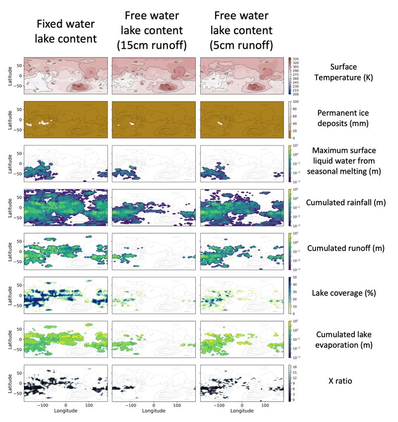
of paleo-topography of Mars – at the time most valley networks formed, near the Late Noachian era – based on
the work of Bouley et al. (2016). Thirdly, we adapted the 3-D ”LMD Generic Early Mars” GCM simulations to
account for the effect of oceans (considering several sizes) and more importantly for the long-term effect of impact
crater lakes that would form in a warm climate. For this purpose the GCM is coupled to a simple asynchronous
model of the long-term evolution of possible martian glaciers and lakes.
    The manuscript is organized as follows. In Section 2, we present the early Mars version of the 3-D LMD
Generic Global Climate Model, with a focus on all the improvements made (1) to account for the greenhouse
warming produced by reducing gases and (2) to account for hydrologic feedbacks (oceans, lakes and glaciers). In
Section 3.1, we reassess the amount of hydrogen required to produce fluvial activity on Mars, based on the results
of 3-D climate simulations. We then explore in Section 3.2 the nature(s) of the early Mars climate and hydrology
for strong greenhouse warming scenarios, and for a wide range of possible total water inventories. Eventually,
discussions and conclusions are provided in Section 4.

2     Method
We used the LMD Generic Model, a full 3-Dimensions Global Climate Model (GCM) that initially derives from
the LMDz Earth (Hourdin et al., 2006) and Mars (Forget et al., 1999) GCMs. This GCM has previously been
developed and used for the study of the climate of ancient Mars (Forget et al., 2013; Wordsworth et al., 2013, 2015;
Kerber et al., 2015; Turbet et al., 2017; Palumbo et al., 2018; Turbet and Forget, 2019; Turbet et al., 2020b).

2.1     General description of the model
Simulations presented in this paper were performed at a horizontal resolution of 64 × 48 (e.g. 5.6◦ × 3.75◦ ; at
the equator, this gives in average 330 km × 220 km) in longitude × latitude. In the vertical direction, the model
is composed of 26 distinct atmospheric layers, covering altitudes from the surface up to ∼ 10 Pascals. Hybrid
σ coordinates (where σ is the ratio between pressure and surface pressure) and fixed pressure levels were used
in the lower and the upper atmosphere, respectively. The dynamical time step of the simulations is 92 s. The
radiative transfer and the physical parameterizations are calculated every ∼ 1 hour and ∼ 15 minutes, respectively.
Parameterizations of turbulence and convection, full CO2 and H2 O cycles (condensation, evaporation, sublimation,
cloud formation, precipitation, etc.), were all parameterized as in Wordsworth et al. (2013) and Turbet et al. (2017).
We focus below on the new parameterizations developed specifically for the present study.

2.1.1    Radiative Transfer
The GCM includes a generalized radiative transfer code able to account for a variable gaseous atmospheric composition
made of a mixture of CO2 , H2 , and H2 O (line list and parameters were taken from HITRAN 2008 database
(Rothman et al., 2009)) using the ’correlated-k’ approach (Fu and Liou, 1992) suited for fast calculation. Our
correlated-k absorption coefficients directly derive from Wordsworth et al. (2013). They take into account the CO2
Collision-Induced Absorptions (Gruszka and Borysow, 1998; Baranov et al., 2004; Wordsworth et al., 2010), as
well as the H2 O MT CKD continua (Clough et al., 2005). Compared to Wordsworth et al. (2013), we added the

                                                          4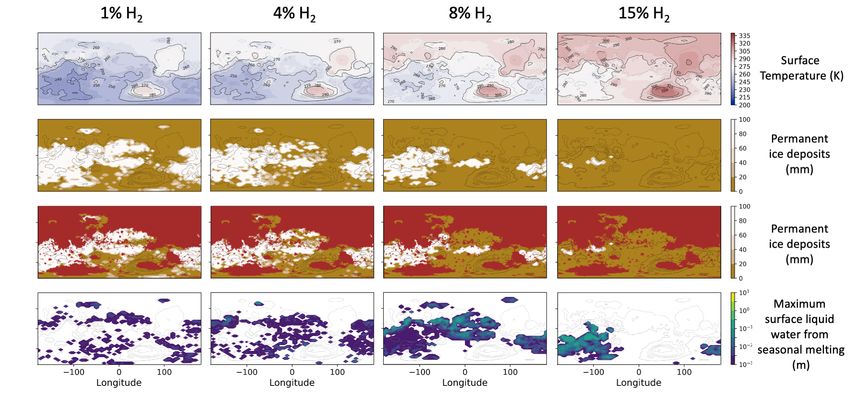
Physical parameters                       Values

Mean Solar Flux                           111 W m−2 (75% of present-day Mars)
Bare ground albedo                        0.2
Liquid water albedo                       0.07
H2 O ice albedo                           0.55
CO2 ice albedo                            0.5
Obliquity                                 40◦ (∼ most probable value, Laskar et al., 2004)
Orbital eccentricity                      0 (circular orbit)
Surface Topography                        Pre-True Polar Wander (modified if oceans are present)
Surface roughness coefficient             0.01 m
Ice thermal inertia                       1500 J m−2 s−1/2 K−1
Ground thermal inertia                    250+7 xH2 O . J m−2 s−1/2 K−1 , where xH2 O is the soil moisture (in kg m−3 )
CO2 partial pressure                      1 or 2 bars
No. of CO2 ice cloud cond. nuclei (CCN)   105 kg−1 (Forget et al., 2013)
No. of H2 O cloud cond. nuclei (CCN)      4 × 10⁶ kg−1 (liquid), 2 × 10⁴ kg−1 (ice) (Leconte et al., 2013a)
H2 O precipitation threshold              0.001 kg kg−1

             Table 2: Summary of the main physical parameters used in the GCM for this study.

                                                    5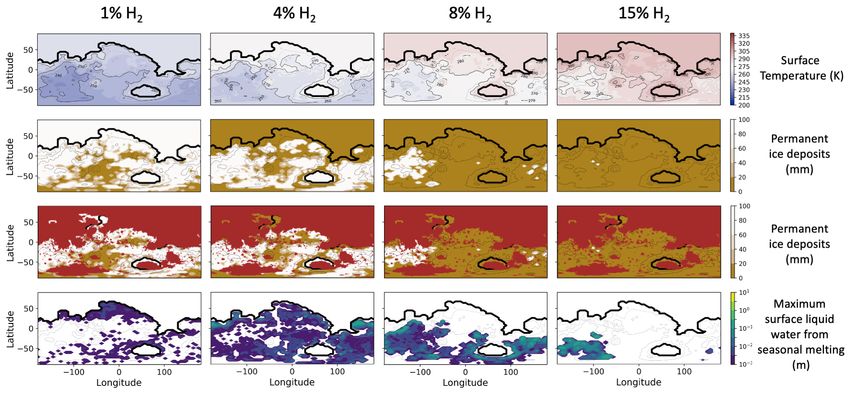
radiative effect of H2 through self H2 -H2 and foreign CO2 -H2 collision-induced absorptions (CIA). H2 -H2 CIAs
were taken from HITRAN CIA database (Richard et al., 2012; Karman et al., 2019). CO2 -H2 CIAs were taken
from Turbet et al. (2020a).
    We adopted here a mean solar flux of 111 W.m−2 (75% of the present-day value of Mars; 32% of Earth’s
present-day value; as in Wordsworth et al. 2013), corresponding to the reduced luminosity derived from standard
solar evolution models (Gough, 1981) 3.7 Gya, during the Late Noachian era.

2.1.2     Topography
We used the pre-True Polar Wander (pre-TPW) topography (see Fig 1, second row) from Bouley et al. (2016).
Bouley et al. (2016) showed that the formation of the late Noachian valley networks is likely to have predated the
formation of most of the Tharsis volcanic bulge. The pre-TPW topography is based on the present-day MOLA
(Mars Orbiter Laser Altimeter) Mars surface topography shown in Figure 1, first row (Smith et al., 1999; Smith
et al., 2001), but without Tharsis and all the younger volcanic features. Moreover, the formation of Tharsis has
been shown to have produced a large True Polar Wander (TPW) event of 20◦ -25◦ , which is also taken into account
in the pre-TPW topography. This topography was adopted for numerical climate simulations assuming low water
contents (low enough that no permanent ocean is formed). In the simulations that account for an ancient ocean, the
pre-TPW topography was adjusted (see Fig 1, third and fourth rows) so that the minimum altitude were -4.26 and
-2.54 km1 :

      • The -4.26 km shoreline case (third row) was calculated assuming a total surface water inventory of ∼ 100 m
        GEL.

      • The -2.54 km shoreline case (fourth row) corresponds to the putative northern ocean shoreline based on delta
        deposit locations from Di Achille and Hynek (2010). ∼ 550 m of global equivalent layer (GEL) is needed to
        reach this shoreline. Wordsworth et al. (2015) and Kamada et al. (2020) adopted a similar ocean elevation,
        but used the present-day Mars MOLA topography.

      All regions matching these elevations were then treated as ’oceanic regions’.

2.1.3     Parameterization of oceanic regions
We used the simplified ocean model from Codron (2012) to treat oceanic regions. This model has been previously
used to explore the past climate(s) of the Earth (Charnay et al., 2013). The modeled ocean is composed of
two layers. The first upper layer (50 m deep) represents the surface mixed layer, where the exchanges with the
atmosphere take place. The second lower layer (150 m deep) represents the deep ocean. The oceanic model
computes the formation of sea ice. Sea ice forms when the ocean temperature falls below 273 K and melts when its
temperature rises above 273 K. The changes in ice extent and thickness are computed based on energy conservation,
keeping the ocean temperature at 273 K as long as ice is present. A layer of snow can be present above the ice,
and the surface albedo is calculated accordingly (Codron, 2012; Charnay et al., 2013). The transport of heat by
  1
      These negative altitudes are defined according to the reference MOLA topography map (Smith et al., 1999; Smith et al., 2001).

                                                                     6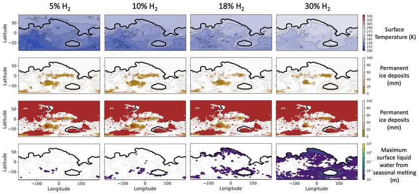
Figure 1: Topography maps discussed and used in our work. The topography map (top row) is the present-day
Mars MOLA topography (Smith et al., 1999; Smith et al., 2001). Although it is not used in our study, we put it here
as a reference. The second row corresponds to the pre-TPW (pre-True Polar Wander) topography map (Bouley
et al., 2016). The third and fourth rows correspond to the pre-TPW topography maps with the inclusion of ancient
oceans (with -4.26 and -2.54 km shorelines, respectively).

                                                        7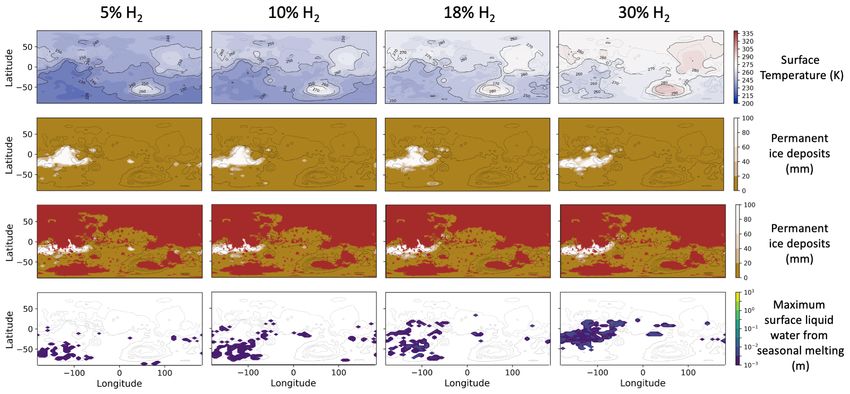
Figure 2: Thermal inertia of the soil as a function of the liquid water loading (in kg/m3 ). The black line corresponds
to the standard parameterization used in the ORCHIDEE Earth land model (Wang et al., 2016). The red curve
corresponds to the parameterization that we used in the present study to account for the thermal inertia of the
Martian ground in early Mars conditions. Our parameterization is compatible with both (1) a standard dry ground
thermal inertia of 250 J m−2 s−1/2 K−1 and (2) the water-loading-dependency of the thermal inertia used in the
ORCHIDEE Earth land model.

the ocean circulation is not taken into account here (nb: it is provided by the model, but not yet available in a
parallelized form). The transport of sea ice is not either taken into account.

2.1.4   Parameterization of continental regions
2.1.4.1 Soil Model To account for the thermal conduction in the subsurface in continental regions (i.e. all
non-oceanic regions), we used a 20-layers thermal diffusion soil model. The mid-layer depths range from d0 ∼ 0.15 mm
to d19 ∼ 80 m, following the power law dn = d0 × 2n with n being the corresponding soil level, chosen to take into
account both the diurnal and seasonal thermal waves.
    We assumed the thermal inertia of the regolith Iground to be equal to:

                                               Iground = Idry + 7 xH2 O ,                                          (1)

where Idry = 250 J m−2 s−1/2 K−1 and xH2 O is the soil moisture (in kg m−3 ). The dry regolith thermal inertia is
slightly higher than the present-day Mars global mean thermal inertia in order to account for the higher atmospheric
pressure (Piqueux and Christensen, 2009) which increases the thermal conductivity of the soil because of the gas in
the pores of the soil. This expression (plotted in Fig 2) has been derived from the standard parameterization of the

                                                           8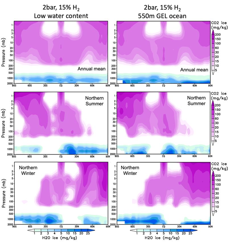
ORCHIDEE (Organising Carbon and Hydrology In Dynamic Ecosystems) Earth land model (Wang et al., 2016).
Moreover, we arbitrarily fixed the thermal inertia of the ground to a value of 1500 J m−2 s−1/2 K−1 , whenever the
snow/ice cover exceeds a threshold of 1000 kg m−2 (e.g. ∼ 1m).
    We assumed that the Martian regolith has a maximum water capacity of 150 kg m−2 , based on a simple bucket
model widely used in the Earth land community (Manabe, 1969; Wood et al., 1992; Schaake et al., 1996) 2 . When
the water quantity exceeds this limit, the overage is treated as runoff. Similarly, we limit the maximum amount of
snow/ice surface deposits to 3000 kg m−2 (i.e. ∼ 3 m).

2.1.4.2 Parameterization of ancient impact crater lakes in the GCM The continental or unsubmerged regions
of the planet are covered by a large number of craters that can potentially host lakes. It is crucial to include these
lakes in early Mars climate models because the presence of lakes controls whether the different regions of Mars are
desertic or not, which may have further effects on regions of precipitation. The accumulation of water in impact
crater lakes can change the intensity and spatial distribution of evaporation and, more broadly, affect the global
hydrologic cycle.
    For each unsubmerged region (i.e. non-oceanic region), we allowed a fraction αlake of up to 0.49 (i.e. 49%)
of the surface to be covered by lakes. According to the model of Matsubara et al. (2011), this is the maximum
possible fraction of submerged regions in the highly craterized Martian terrains, before all the lakes overflow .
    In our parameterization, the contribution of lakes is twofold:

      • First, we consider them as a source of water vapor, and we calculate their combined rate of evaporation E (or
        sublimation, if the temperature is below 273 K) averaged over the grid mesh (in kg m−2 s−1 ) as follows:

                                                   E = αlake ρ1Cd V1 [qsat (T surf ) − q1 ]                            (2)

        where ρ1 and V1 are the volumetric mass of air (kg m−3 ) and the wind velocity (m s−1 ) in the first atmospheric
        model level, qsat (T surf ) is the water vapor mass mixing ratio at saturation at the surface (kg kg−1 ), and q1 is
        the mass mixing ratio in the first atmospheric layer. The aerodynamic coefficient is given by

                                                Cd = (κ/ln(1 + z1 /z0 ))2 ∼ 2.5 × 10⁻³                                 (3)

        where κ = 0.4 is the Von Karman constant, z0 is the surface roughness coefficient (set to 0.01 m) and z1 is
        the altitude of the first atmospheric level (∼ 20 meters). Simultaneously, evaporation from the surrounding
        regolith terrains (when wet or ice-covered, for instance after precipitation) is then multiplied by a factor
        (1-αlake ).

      • Secondly, we took into account the effect of lakes on the surface albedo. If the surface temperature is below
        or equal to 273 K, the albedo of the lakes is 0.55; otherwise it is 0.07.

      The formation and evolution of the impact crater lakes are discussed in the next subsection.
  2
      This is actually known as the ”Manabe” bucket model.

                                                                  9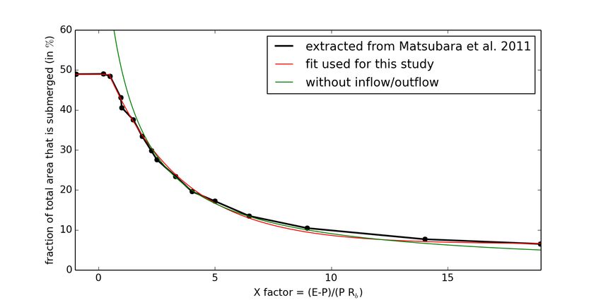
2.2     Determining where glaciers and lakes stabilize
All GCM simulations were first run for 10 Martian years as in Forget et al. 2013 to reach a first atmospheric
equilibrium, with surface and atmospheric temperatures roughly equilibrated. Yet, it would take several orders of
magnitude longer for the water cycle to reach an equilibrium. The reason is twofold:

      • First, in the regions that are cold enough for permanent ice deposits to exist, sublimation and light snowfall
        are the dominant forms of water transport. Water ice distribution can then take thousands of years and even
        much more to reach a steady state (Wordsworth et al., 2013; Turbet et al., 2017).

      • Secondly, the evolution of impact crater lakes to their final size and location can also take a very long time,
        because this evolution results from a slow competition between evaporation of the lake, precipitation on the
        lake, and runoff from surrounding terrains.

2.2.1    Evolution of ice deposits
The locations of stable surface ice deposits were calculated using the ice equilibration algorithm of Wordsworth
et al. (2013), later used in Turbet et al. (2017). After the first ten Martian years of evolution, we proceeded with the
following repeated steps:

   1. We run the GCM for two Martian years.

   2. We extrapolate the evolution of the ice layer field hice over nyears number of years using:

                                           hice (t + nyears ) = hice (t) + nyears × ∆hice ,                         (4)

        with ∆hice the annual mean ice field change of the one-Martian-year previous simulation.

   3. We eliminate the seasonal ice deposits.

   4. We limit the extrapolated ice field to a maximum value of 3000 kg m−2 (i.e. ∼ 3 m).

   5. We repeat the process.

    This algorithm was shown (Wordsworth et al., 2013) to be insensitive to the initial ice field location at the
beginning of the simulation, assuming that the scheme was repeated a sufficient number of times. In total, for our
control simulations, we looped the algorithm 20 times, with nyears =50 years for the first 10 loops and nyears =20
for 10 more loops. Because our simulations are much warmer than those of Wordsworth et al. (2013), the water
transport is much more efficient, and the convergence of the algorithm is more rapid. Note that, for the cases of
”dry” simulations (those that do not include oceans), we arbitrarily normalized the total amount of permanent water
ice deposits to 1 m GEL after each iteration of the ice equilibrium algorithm.

                                                             10
Figure 3: Fraction of lakes area (black line) covering a craterized terrain as a function of the aridity index “X-ratio”
(see text), derived from the results of Matsubara et al. (2011). The red line is the fit that we used for the lake
evolution algorithm. Without inflow/outflow, αlake = X+1 1
, corresponding to the green line.
112.2.2 Formation and evolution of impact crater lakes
To calculate the formation and evolution of impact crater lakes, we developed an algorithm based on the results of
the Martian hydrology model of Howard (2007) and Matsubara et al. (2011). Our algorithm relies on the “X-ratio”
(a proxy for the aridity of the region), defined as:
E−P
X= , (5)
PRb
with P the annual mean rate of precipitation (m/year), E the annual mean rate of evaporation above the lakes
only (m/year), Rb is the fraction of precipitation above the unsubmerged land and that ends up in runoff, in the lake.
These three quantities can be recorded at each grid point in our Global Climate Model simulations. Matsubara et al.
(2011) provides a useful relationship between the surface fraction of lakes αlake with this aridity index X-ratio, for
a highly craterized terrain typical of Late Noachian terrains. This relationship is plotted in Fig 3 (black line). We
fit this relationship (red line) as follows:
αlake = 49 for X < 0.5
0.5−X
αlake = 6.5 + 42.5 e 3.2 for 0.5 < X < 19
(6)
αlake = 0 for X > 19
where αlake (X) is expressed in %. In short, a low value of X means that the lakes must grow in coverage to increase
the evaporation surface, and thus reach hydrological equilibrium. A high value of X, on the other hand, indicates
that lakes must reduce in size to limit the rate of evaporation and thus also reach hydrological equilibrium.
Our lake formation and evolution algorithm (run in parallel with the ice equilibrium algorithm described above)
is as follows: After the first ten Martian years of evolution we proceed with the following steps:
1. We run the GCM for two Martian years. During the second year, at each timestep we record (i) the
precipitation over each grid mesh, (ii) the evaporation of the lakes over each grid mesh (= 0 if there is
no lakes) and (iii) the runoff from unsubmerged lands to lakes. In each grid mesh, we assume that 100% of
the water that runoff (when the soil water content exceeds 150 kg m−2 ) end up in the lakes of the same grid
mesh.
2. We calculate the aridity X-ratio for each GCM grid.
3. We estimate αlake (X) based on equations 6. We limit the variation of the coverage of the lakes to 10 % from
one step of the algorithm to the next, in order to avoid numerical unstabilities.
Note that the last step of this algorithm does not conserve water. This is an issue only for the dry and warm
simulations (those for which the entire water inventory can be trapped in impact crater lakes). For the dry (dry
enough so that no permanent ocean is present) and warm (warm enough so that water is not fully trapped as ice)
simulations, we arbitrarily normalize the total amount of water stored in impact crater lakes to the initial total water
content (e.g. arbitrarily fixed to 4 m GEL here, for the dry simulations) after each iteration of the lake evolution
algorithm. We discuss the impact of this renormalization (with the help of sensitivity studies) in Section 3.2.
122.3 Initial states of the simulations
In this section we describe the initial simulation setups, summarized in Table 3. Initially, the surface/subsurface/atmosphere
temperatures were arbitrarily fixed to 300 K everywhere on the planet.
We distinguish two main categories of initial states, depending on the total water content:
• Cases where early Mars is water-rich (i.e. oceans are present). In these scenarios, we initialized
non-oceanic regions with completely dry conditions. Oceanic regions were assumed to be initially fully
deglaciated, with a uniform temperature of 300 K.
• Cases where early Mars is water-poor (i.e. no oceans are present). In these scenarios, we assumed that
all the water was initially trapped as liquid water in impact crater lakes uniformly distributed on the surface.
The initial total water content is arbitrarily fixed to 4 m GEL. For the warm simulations (warm enough so
that water is not fully trapped as ice), the lake algorithm renormalization step maintains the total amount of
water at 4 m GEL. For the cold simulations (cold enough that water can accumulate as ice on the coldest
points of the planet), the lake algorithm renormalization step is not performed, and the amount of water is
therefore not conserved. In this particular case, the amount of water is highly dependent on the amount of
water trapped as ice. The final amount of water is not strictly speaking fixed because it depends on the size
of the glaciers considered.
The amount of water hH2 O trapped in impact crater lakes in each grid mesh can be calculated using Figs. 3 and
4, based on Matsubara et al. (2011). Using a hydrologic routing model coupled with Mars topography, Matsubara
et al. (2011) estimated the averaged relationship between the surface area of lakes and their averaged depth on the
craterized ancient surface of Mars. We fitted these result with the following empirical relationship (that excludes
the contribution of the largest Martian craters):
26
hH2 O = 21.7 − (7)
(1 + αlake /100)4
with hH2 O the amount of water in lakes averaged over the grid mesh area (equivalent layer in meters, or 1000 kg
m−2 ) and αlake in %. hH2 O . hH2 O can be integrated over the planet to provide the total inventory of water trapped
in lakes. For reference, the total amount of water that can be trapped in impact craters before all lakes overflow
is ∼ 60 m and 500 m GEL, without and with the contribution of the largest Martian craters (mainly Hellas and
Argyre), respectively.
The list of simulations performed and discussed in our work is summarized in Table 3.
3 Results
3.1 How much hydrogen is required to warm early Mars?
An important aspect of the feasibility of the H2 greenhouse warming scenario is to assess whether or not the
amount of H2 required to warm early Mars is compatible with the possible H2 production rates (Ramirez et al.,
13Figure 4: Mean lake depth (in m) versus aridity X-ratio, derived from the results of Matsubara et al. (2011). Note
that the mean lake depth at low X-ratio (typically lower than 4, denoted by the position of the dotted, vertical line)
is biased by the contribution of the largest impact craters (Hellas, Argyre, etc.).
14Table 3: List of simulations discussed in this work. Additional simulations (not listed here) were also conducted for
sensitivity experiments (in particular, relative to the lake algorithm). These sensitivity experiments are discussed
later in the manuscript. The amount of additional H2 is reported in volume mixing ratio.
Simulation CO2 surface pressure Amount of additional H2 Ocean
1 1 bar 5% yes (550m GEL)
2 1 bar 10% yes (550m GEL)
3 1 bar 15% yes (550m GEL)
4 1 bar 18% yes (550m GEL)
5 1 bar 22% yes (550m GEL)
6 1 bar 30% yes (550m GEL)
7 1 bar 5% no
8 1 bar 10% no
9 1 bar 15% no
10 1 bar 18% no
11 1 bar 22% no
12 1 bar 30% no
13 2 bar 0.5% yes (550m GEL)
14 2 bar 1% yes (550m GEL)
15 2 bar 2% yes (550m GEL)
16 2 bar 3% yes (550m GEL)
17 2 bar 4% yes (550m GEL)
18 2 bar 6% yes (550m GEL)
19 2 bar 8% yes (550m GEL)
20 2 bar 10% yes (550m GEL)
21 2 bar 15% yes (550m GEL)
22 2 bar 1% no
23 2 bar 2% no
24 2 bar 3% no
25 2 bar 4% no
26 2 bar 6% no
27 2 bar 8% no
28 2 bar 10% no
29 2 bar 15% no
30 2 bar 4% yes (100m GEL)
31 2 bar 15% yes (100m GEL)
152014; Wordsworth et al., 2017; Kamada et al., 2020; Turbet et al., 2020a; Hayworth et al., 2020; Wordsworth
et al., 2021). The amount of hydrogen required to ”warm” early Mars has been mainly calculated provided that
the global mean surface temperature is above the melting point of water i.e. 273 K. In this section, we revise
these numbers based on three distinct constraints (described in the three following subsections) derived from our
3-D global climate simulations: (1) the annual mean globally-averaged surface temperature is above 273 K, or (2)
surface liquid water must be present, or (3) the surface temperature of the coldest points must be above 273 K to
avoid glacier formation (i.e. to solve the so-called equatorial periglacial paradox).
3.1.1 Impact of the CO2 and H2 mixing ratios on the global mean surface temperature
The surface temperature is controlled by a large number of factors including (but not limited to) greenhouse effect,
Rayleigh scattering and heat redistribution by CO2 , H2 and water ; radiative effects of clouds ; surface albedo
changes. Fig 5 summarizes the evolution of the annual-mean globally averaged surface temperature as a function
of H2 mixing ratio, for two different CO2 partial pressures (1 and 2 bar), and three different water contents (dry,
100 m GEL ocean and 550 m GEL ocean). Two families of solutions appear depending on whether the CO2 partial
pressure of CO2 is equal to 1 or 2 bar. Simulations at 1 bar require about 4 × more hydrogen than simulations at
2 bar to reach a surface temperature of 273 K. This stems mostly from the fact that the CO2 -H2 collision-induced
absorption cross-section is proportional to pCO2 × pH2 = p2CO2 × xH2 , which is also ∼ 4 × higher in the 2 bar
simulation than in the 1 bar simulation.
We first focus on the 1 bar family solution, which is the most plausible solution given the constraints on the
past atmospheric pressure of Mars derived from crater counting (Kite et al., 2014) and estimates of atmospheric
escape rates (Lillis et al., 2017; Dong et al., 2018). For the 1 bar CO2 -dominated atmosphere, globally-averaged
surface temperatures in 3-D simulations are generally colder than calculated with a 1-D model (Turbet et al., 2020a)
with the same atmospheric composition. This is mainly due to the increase of the planetary albedo linked to the
reflectivity of ice deposits accumulating on the surface, as illustrated in Fig 6a, second row (and to a lesser extent
in Fig 6b, second row). This effect is not included in the 1-D model that assumes a fixed surface albedo equal to 0.2
(Turbet et al., 2020a). The difference on the surface temperature is strongest for the ocean simulations (lower blue
line in Fig 5). Our 3-D simulations indicate in fact that water that evaporates from the ocean is initially deposited
almost everywhere on the planet. As the planet cools down, water freezes on the elevated terrains, which increases
the albedo, which decreases the mean temperature, and induces even more freezing (e.g. the freezing of the ocean).
This is the ice albedo positive feedback. As illustrated by Fig 6a (second row), the planet is rapidly covered by
ice (i.e. becomes a ”Snowball Mars”) and the mean surface temperature drops to really low values. Note that this
effect could possibly be taken into account in 1-D climate models by adjusting/parameterizing the surface albedo
(Ramirez and Craddock, 2018), although the presence of clouds make the estimation complex. For scenarios with
a small water content (lower red line in Fig 5), the difference in surface temperature between the 1D and 3D models
is much less pronounced. This is due to the fact that the ice albedo feedback is much less pronounced due to limited
ice surface coverage, as illustrated by Fig 6b (second row). Ice deposits accumulate in fact on the most elevated
terrains of Mars, the cold traps, due to the adiabatic cooling mechanism (Forget et al., 2013), in agreement with
Wordsworth et al. (2013).
We now focus on the 2 bar family solution, which has the advantage (over the 1 bar simulations) of requiring
16Figure 5: Annual global mean surface temperatures (K) as a function of H2 mixing ratio, for two different CO2
partial pressures (1 and 2 bar), and four different types of simulations. These include 1-D simulations (black) based
on Turbet et al. (2020a), 3-D simulations assuming a dry (i.e., low water content) planet (brown), a planet with a
small 100 m GEL ocean (orange), and a planet with a large 550 m ocean (blue).
17(a) 1 bar of CO2 , 550 m GEL ocean
(b) 1 bar of CO2 , no ocean
Figure 6: Annual mean surface temperatures (first row), permanent ice deposits (second row), permanent ice
deposits filtered from post-Noachian terrains (third row) following Tanaka et al. (2014), and maximum surface
liquid water produced by seasonal melting (fourth row) maps. Maps were calculated for a 1 bar CO2 -dominated
atmosphere with various H2 contents (5, 10, 18 and 30%), for a large water reservoir (upper panel) and for a
18
small water reservoir (lower panel). For the simulations without ocean, the maximum amount of water than can be
trapped in water ice glaciers is ∼ 280/210/120/40 m for hydrogen mixing ratio of 5/10/18/30%, respectively. For
the simulations with ocean, this amount is ∼ 1500/1300/1000/600 m for hydrogen mixing ratio of 5/10/18/30%,
respectively. These maximum amounts are calculated assuming that glaciers stop thickening when they experience
basal melting (“basal melting limit”), using a geothermal heat flux equal to 50 mW m−2 .(a) 2 bar of CO2 , 550 m GEL ocean
(b) 2 bar of CO2 , no ocean
Figure 7: Same as Figure 6 but for a 2 bar CO2 -dominated atmosphere with H2 contents of 1, 4, 8 and 15%. For the
simulations without ocean, the maximum amount of water than can be trapped in water ice glaciers (basal melting
limit) is ∼ 480/220/60/0 m for hydrogen mixing ratio of 5/10/18/30%, respectively. For the simulations with ocean,
this amount is ∼ 630/200/20/0 m for hydrogen mixing ratio of 5/10/18/30%, respectively.
19Amount of CO2 1 bar 2 bar
1D model (Turbet et al., 2020a) 27% 7%
3D model with large oceans >30% 5.5%
3D model with no oceans 30% 6.5%
Table 4: H2 volume mixing ratio (in %) required to warm the annual-mean globally averaged surface temperature
of early Mars above 273K, depending on the assumed CO2 partial pressure (1 or 2 bar), calculated with the LMD
Early Mars Generic GCM including the CO2 -H2 collision-induced absorption of Turbet et al. (2020a).
much less H2 to yield temperate temperatures. For the 2 bar CO2 -dominated atmosphere, globally-averaged surface
temperatures in 3-D simulations are in fact generally warmer than calculated with a 1-D model (Turbet et al., 2020a)
with the same atmospheric composition. This occurs in spite of the fact that the coverage of surface ice is found
to be relatively large (see Figs. 7a and 7b, second row) at least for low H2 mixing ratios. In fact, we identify
that the most significant difference (with respect to the 1 bar simulations) is that the greenhouse effect of CO2 ice
clouds (not included in 1-D calculations) is much more pronounced here (see Fig 8). This is in agreement with the
results of Forget et al. 2013 (see Figs. 1 and 2) showing that the greenhouse effect of CO2 ice clouds significantly
increases with CO2 partial pressure, with an optimum warming near 2 bar. Fig. 8 illustrates that CO2 ice clouds
form seasonally – in Winter – in the upper part of the atmosphere (at pressures typically lower than 0.2 bar) where
they backscatter efficiently the thermal emission of the surface and the lowermost part of the atmosphere, while
having a limited impact on the planetary albedo.
The H2 mixing ratios needed to raise the annual-mean globally averaged surface temperature above 273 K are
summarized in Table 4. The H2 mixing ratios are all significantly higher than those calculated in Kamada et al.
(2020), mostly because they used the older CIA coefficients from Wordsworth et al. (2017). Moreover, we note
some qualitative discrepancies with the simulations presented in Kamada et al. (2020). In both the 1 bar and 2 bar
families of solutions presented in our work, we observe that the annual-mean globally averaged surface temperature
is lower in the ocean case than in the dry case when the planet is cold (cold enough to freeze most surface water),
and the result is the opposite when the planet is warm (warm enough so that surface ice deposits are limited in size),
due to the ice albedo feedback. This behaviour is not found by Kamada et al. (2020), where annual-mean globally
averaged surface temperature for their ”Aqua-Mars” simulations (i.e. with oceans) is always higher than that of
their ”Dry-Mars” or ”Moist-Mars” (i.e. without oceans), whatever the CO2 and H2 partial pressures considered.
3.1.2 Surface temperature above 273 K is not always a sufficient condition for the presence of surface liquid
water
The fact that the global mean surface temperature of a planet is above the melting point of water (273 K) does
not necessarily mean that liquid water exists on its surface. On planets with a limited water reservoir, water is
indeed expected to migrate to the coldest points of the planets (Abe et al., 2011; Menou, 2013; Leconte et al.,
2013b; Turbet et al., 2016), i.e. to the polar regions on present-day Mars and Earth, and possibly to the southern
highlands on early Mars endowed with a thick CO2 atmosphere (Wordsworth et al., 2013; Turbet et al., 2017), due
to the adiabatic cooling mechanism. Preferential water accumulation in the coldest points of the planet (southern
20Figure 8: Meridional means of the H2 O and CO2 ice cloud distributions, for a low water content (water content
below a few meters GEL ; left column) and a large northern ocean (about 500 meters GEL ; right column), for
1 Martian year average (top row), 10 Martian days average near the Northern Summer solstice (middle row) and
10 Martian days average near the Northern Winter solstice (bottom row). The figure is computed for atmospheres
made of 2 bar of CO2 and 15% of H2 .
21Amount of CO2 1 bar 2 bar
condition 1 3D model with large oceans 18% 1%
(melt production >1cm) 3D model with no oceans 5% 1%
condition 2 3D model with large oceans >30% 3%
(perennial surface liquid water on land) 3D model with no oceans >30% 6%
condition 3 3D model with large oceans >30% 3%
(ocean/lakes not fully ice-covered)
Table 5: H2 volume mixing ratio (in %) required to have perennial surface liquid water, depending on the assumed
CO2 partial pressure (1 or 2 bar), and for three distinct conditions (see main text).
highlands) is also clearly visible in Figs. 6b and 7b, second row.
We evaluated in our simulations three distinct conditions (in H2 mixing ratio) for the presence of surface liquid
water: (condition 1) the total annual production of surface liquid water (most likely by melting) is larger than
1 cm in at least one GCM grid ; (condition 2) liquid water is continuously present on the surface in at least one
continental GCM grid ; (condition 3) oceans/lakes are not entirely covered by ice. The results are summarized in
Table 5. The first condition correspond to a very small amount of water in comparison to the estimated amount
needed to carve the valley networks (Luo et al., 2017; Rosenberg et al., 2019; Luo et al., 2020). It is easier to
achieve (i.e., require less H2 ) than the third, which itself is easier to achieve than the second. In most simulations,
these three conditions are also easier to achieve than having the global mean surface temperature above 273 K.
Simulations with 1 bar of CO2 (which is also the most likely scenario family as hypothesized in Wordsworth
et al. 2013 and Wordsworth 2016) require extremely high hydrogen mixing ratios (≥30%) not only to raise the
global mean surface temperature above 273 K (see Table 4), but also to allow the presence of perennial surface
liquid water on land (see Table 5). As detailed in Section 3.1.1, this stems from the fact that compared with 1-D
numerical climate calculations with up-to-date CO2 +H2 CIA (Turbet et al., 2020a), (1) in 3-D simulations with
an ocean, a strong ice albedo feedback takes place, which produces a strong cooling ; and (2) in 3-D simulations
with a low water content, water tends to accumulate on the elevated southern highland terrains, which are also the
coldest terrains of the planet, and is thus more difficult to melt.
3.1.3 Constraints from the equatorial periglacial paradox
It has been argued that the presence (in 3D GCM simulations) of water ice glaciers in the Martian highlands is an
issue, because there is no clear evidence of widespread glacial erosion on these terrains (Ramirez and Craddock,
2018). This issue is known as the ”equatorial periglacial paradox” (Wordsworth, 2016). Ramirez and Craddock
(2018) advocated that that this so-called ”equatorial periglacial paradox” is a piece of evidence against the ”icy
highland” scenario (Wordsworth et al., 2013; Bouley et al., 2016), i.e. the possibility that late Noachian valley
networks may have formed mainly from the seasonal melting of glacial deposits that accumulated on the southern
highlands.
Most of the simulations discussed above predict the formation of permanent water ice reservoirs. Even simulations
with global mean surface temperature well above 0◦ C also show water ice accumulation, at least in the southern
22highlands. In such cases, glacial activity and thus erosion are likely to be amplified due to higher surface temperatures
(at least, compared with colder simulations, with lower H2 mixing ratios), as illustrated in Figs. 6a, 6b, 7a and 7b,
first row.
We evaluated in our simulations two distinct conditions (in H2 mixing ratio) that may allow to overcome the
equatorial periglacial paradox: (condition 1) no ice accumulation occurs in the GCM simulation (¡1 m GEL) ;
(condition 2) no ice accumulation occurs in the GCM grids corresponding to Noachian (or older) terrains (¡1 m
GEL). The results are summarized in Table 6. We found that the H2 mixing ratios required to reach one or the
other of the condition is the same. This stems from the fact that the adiabatic cooling mechanism tends to form
ice deposits on the southern highlands (Wordsworth et al., 2013; Bouley et al., 2016; Turbet et al., 2017) which
are mostly Noachian terrains. In all configurations (i.e. for all water contents and CO2 pressures considered), the
absence of ice deposits on Noachian terrains requires significantly more hydrogen (e.g., more than twice for the
simulation with 2 bar of CO2 and large oceans) than having the global mean surface temperature above 273 K. This
is due to the fact that preventing glacier formation requires having the coldest points of the planets above 273 K,
which is a much more stringent condition.
In any case, even if the climate was warm enough to avoid the formation of glaciers for some time, it seems
difficult to avoid glacier formation when the climate transitioned to colder epochs (for example when the H2 mixing
ratio was much lower), as discussed in Wordsworth (2016).
One possibility to resolve this apparent paradox is that the glaciers could have had a cold base, which would
drastically reduce glacial erosion on the highlands (Fastook and Head, 2015). Whether glaciers had a cold base
or not depends on the water content available at the surface and in the atmosphere at the Late Noachian epoch, as
well as the surface temperature in the highlands and the geothermal heat flux. In warm simulations (i.e. with large
amount of H2 ) the area over which glaciers form gets smaller (with respect to the cold simulations with low amount
of H2 ). However it is also expected that – for a fixed amount of surface water – glaciers should have a warmer base,
and thus be more likely to achieve glacial erosion. Counterintuitively, and unless the atmosphere is warm enough
to totally prevent the formation of glaciers, warm climates should lead to much more extensive glacial erosion than
cold climates.
Another possibility to solve the paradox is that traces of glacier flows are present but so altered that they have
not yet been detected. Recent works (Bouquety et al., 2019, 2020) reported morphometric evidence of glaciation
(glacial valleys and cirques) in Terra Sabaea (a southern highland terrain), dating back from late Noachian/early
Hesperian. Searches for traces of glacier erosion should now be carried out on a wide range of terrains dating from
the late Noachian/early Hesperian period, especially on the most elevated ones such as Terra Sirenum, where most
of our GCM simulations predict preferential ice accumulation.
3.2 The nature of the hydrologic cycle in warm simulations
The total surface/near-surface water content available during the Late Noachian is still debated (Wordsworth, 2016).
Carr and Head (2015) estimated that the total reservoir could have been as low as ∼ 24 m GEL, based on water
loss/gain budget during the subsequent Hesperian and Amazonian epochs. Villanueva et al. (2015) calculated that
the late Noachian water content was ∼ 60 m GEL, based on present-day Mars isotopic D/H ratio. Eventually, Di
Achille and Hynek (2010) argued that the total water inventory was ∼ 550m GEL, based on possible ancient ocean
23Figure 9: Annual-mean average quantities (surface temperatures, permanent ice deposits, maximum surface
liquid water produced by seasonal melting, cumulated rainfall, cumulated runoff, lake coverage, cumulated lake
24
evaporation and aridity index “X-ratio”) for atmospheres made of 2 bar of CO2 and 15% of H2 , for various total
water inventories. Note that the cumulated lake evaporation must be multiplied by the lake coverage αlake to obtain
the cumulated evaporation for the GCM grid. The “Low water content simulations correspond to a range of water
content of a few meters GEL, depending on how thick the glaciers are (the exact value has no impact on the modeled
climate; see Figures 6 and 7). See Fig 12 for a comparison with the positions of Noachian terrains (Tanaka et al.,
2014) and known valley networks (Bouley et al., 2016).25 Figure 10: Evolution of lake coverage (in %) at timesteps = 0, 1, 4, 9, 15 and 30 for the 2 bar-CO2 , 15%-H2 simulation presented in Figure 9.
Amount of CO2              1 bar    2 bar
                   condition 1                      3D model with large oceans      >30%     10%
                   (no ice)                          3D model with no oceans        >30%     10%
                   condition 2                      3D model with large oceans      >30%     10%
                   (no ice on Noachian terrains)     3D model with no oceans        >30%     10%

Table 6: H2 volume mixing ratio (in %) required to possibly overcome the equatorial periglacial paradox, depending
on the assumed CO2 partial pressure (1 or 2 bar), and for two distinct conditions (see main text).

shorelines determined by the position of deltas.
    We explore in this section how the nature of the early Mars hydrologic cycle under a strong greenhouse warming
(strong enough for rain to be produced and lakes to be formed) changes depending on the assumed total water
inventory. For this we designed a series of 3-D numerical climate simulations (see Table 3) to explore possibles
climates ranging from warm & arid to warm & wet conditions. We focus specifically on simulations with 2 bar
CO2 -dominated atmospheres as they allow warm climates to be achieved with a relatively reasonable H2 mixing
ratio (see Tables 4, 5 and 6).

3.2.1   Warm and arid scenarios
Warm & arid scenarios are cases where the total water content on Mars was low enough so that no oceans formed,
as depicted in Fig 9 (column 1).
     Wordsworth et al. (2013) demonstrated using 3-D Global climate simulations that - in cold and arid scenarios
- water should migrate to the cold traps of the planet (e.g. to the southern highlands) and accumulate there as
ice, through the mechanism of adiabatic cooling and subsequent condensation. We find the same behaviour in our
simulations with low water inventory and moderate greenhouse warming (see e.g. Figs 6b and 7b). However, in
our simulations, the size of the permanent ice reservoirs is more limited, for two reasons:

   • The number of locations on Mars where the annual mean surface temperature is below 0◦ C is reduced.
     Therefore, the number of possible locations where water can accumulate as ice is also reduced.

   • The maximum thickness of the permanent ice reservoirs is also reduced, because of the basal melting limit
     (defined by the maximum thickness of ice deposits before they start to melt at their base) is more restrictive
     at higher surface temperatures.

     In contrast with the predictions of Wordsworth (2016), we actually find a similar behavior in simulations with
a strong greenhouse warming (shown in Fig 9, column 1), i.e. strong enough to prevent the formation or permanent
ice deposits. In these warm & arid simulations, water was initially uniformly distributed in lakes all over the planet
(with an arbitrary mean lake surface coverage of 10% ; this corresponds to a total water content of 4 m GEL).
As illustrated in Fig 10 (column 1), water progressively migrates to regions where the precipitation - evaporation
budget is favorable, i.e. the cold traps. Because of the adiabatic cooling process, the cold traps in our warm
simulations are also located in the southern highlands, as calculated by Wordsworth et al. (2013) in much colder

                                                         26
configurations. As a result, water rapidly migrates to the southern highlands where it accumulates - in liquid form
- in impact crater lakes (see Fig 9, column 1, row 6 ; or Fig 10, column 1, row 6).
Once water is stabilized in southern highlands impact crater lakes, precipitation (rainfall) occurs close to the
reservoirs of water (lakes), i.e. also in the southern highlands (see Fig 9, column 1, row 4). A good predictor of
the regions of valley networks formation is the annual mean cumulated runoff (see Fig 9, column 1, row 5) that
shows that valley networks - in this scenario - would also form in the southern highlands (rainfall are less indicative
because in our model it often rain without yielding runoff because the soil is not saturated; see section 2.1.4). Both
lake formation and runoff (initiated by rainfall) are widespread and mostly located in the southern highlands, were
both impact crater lakes and valley networks have been observed (Fassett and Head, 2008; Hynek et al., 2010). We
note a relatively strong runoff in Arabia Terra, where no valley networks have been directly observed. However,
Davis et al. (2016) identified extensive networks of sinuous ridges, which they interpreted as inverted Noachian
fluvial channels that would have been buried and then exhumed. Our 3-D simulations are in agreement with this
interpretation. Detailed comparisons with regions of valley network formations (Bouley et al., 2016) filtered from
post-Noachian terrains (Tanaka et al., 2014) are provided in Fig 12.
The results of these warm and arid simulations is promising because they show that the adiabatic cooling
mechanism can also work in warm climates, leading to extensive valley network formation on the Martian highlands
as observed. However, there are two issues in this scenario. First, the simulations explored here correspond to a
very low surface water total inventory (∼ 4 m GEL) compared to the range of available estimates (Di Achille and
Hynek, 2010; Villanueva et al., 2015; Carr and Head, 2015). Secondly, a large fraction of the lakes that form in
these simulations are overflowing. Most of the lake forming regions are associated to very low aridity X-ratios (see
Fig 9, column 1, row 8). For a X-ratio lower than ∼ 2, lakes are expected to overflow (Howard, 2007; Matsubara
et al., 2011). Some lakes that reached their maximal size can even have a positive precipitation - evaporation
positive budget. Therefore, in our simulations, a large number of lakes should be open-basin lakes, which seems in
contradiction with the observational evidence that closed-basin lakes greatly outnumber open-basin lakes (Wordsworth,
2016).
This second problem might just be a consequence of the simplicity of our hydrological parametrization. Firstly,
it does not take into account the large scale transport of water by runoff. One could imagine that a few open-basin
lakes feeding rivers able to transport water across several grid meshes could significantly drain and dry a region,
preventing there the formation of overflowing lakes. Secondly, in our simulations we forced the hydrological
scheme to keep the total amount of liquid water trapped in lakes to a fixed value (4 m GEL). We performed several
sensitivity studies (see Fig 11, columns 2 and 3) where we let the martian lakes freely evolve for a total of 20
timesteps, starting from the initial state presented in Fig 9 (left column). We carried out several sensitivity tests
varying the quantity of liquid water before triggering the runoff (from 1.5 cm to 15 cm) because we had identified
this parameter as being the most important in the lake distribution. The results – presented in Fig 11, columns 2
and 3 – show that while the geographical distribution of valley networks remains mostly located on the highlands,
the fraction of overflowing lakes is now very small. However, these results were obtained at the expense of not
conserving water in lakes.
27You can also read