A GUIDE TO - INCORPORATED 1911 - City of Burbank
←
→
Page content transcription
If your browser does not render page correctly, please read the page content below
A GUIDE TO

INCORPORATED 1911
CITY OF BURBANK

 CITY OF PEOPLE, PRIDE, AND
         PROGRESS

YOUR MUNICIPAL GOVERNMENT

        January 2021
FORWARD
This booklet is provided as a brief summary of the
government of the City of Burbank, its functions and activities.
It is our hope that the general information it contains will be
helpful to the many students, residents, and others who have an
interest in local government and the City.
City ClerkTABLE OF CONTENTS
Facts and Figures ..................................................................................... 1
Legislative Representatives ...................................................................... 1
Capsule History ......................................................................................... 2
City Hall Building ..................................................................................... 19
City Seal .................................................................................................. 20
City Flower .............................................................................................. 21
City Tree .................................................................................................. 21
Directory of City Officials ......................................................................... 21
Municipal Calendar ................................................................................. 22
Schedule of Public Meetings ................................................................... 23
Duties and Responsibilities
City Charter ....................................................................................... 24
City Council ....................................................................................... 25
Other Elected Officials ...................................................................... 27
Local Appointments .......................................................................... 28
Appointed Officials ............................................................................ 29
City Departments .................................................................................... 30
Burbank Water and Power ............................................................... 37
Community Development Department ............................................. 31
Financial Services Department ......................................................... 43
Fire Department ................................................................................ 33
Information Technology Department ................................................ 34
Library Services Department ............................................................ 40
Management Services Department .................................................. 45
Park, Recreation and Community Services…………………………..41
Police Department ............................................................................ 36
Public Information Office .................................................................. 29
Public Works Department ................................................................. 38
Phone Directory ..................................................................................... 46FACTS AND FIGURES
INCORPORATED ................................................................... July 8, 1911
CHARTER……. ....................................................................... July 8, 1911
FORM OF GOVERNMENT ...................................... Council-City Manager
NAMED FOR .... Dr. David Burbank, a dentist and early owner of ranch
property located where the City now stands.
LOCATION ....... Eastern part of the San Fernando Valley, 12 miles from
the City of Los Angeles.
AREA .......................................................................... 17.135 square miles
CLIMATE ..................................................... Average Temperature: 62.8oF
RAINFALL ................................................................Average rainfall: 12.1”
ELEVATION: .............................................484 to 957 feet above sea level
HUMIDITY .............................................................. Average humidity: 61%
NUMBER OF EMPLOYEES .............................................................. 1,518
POPULATION ........................................................ Approximately 106,801
REGISTERED VOTERS ..........................................70,367as of July 2020
ASSESSED VALUATION (Fiscal Year 2019-20)............ $ 25,006,187,358
LEGISLATIVE REPRESENTATIVES
Congressional District 28 United States Senator
U. S. Representative Alejandro "Alex" Padilla
Adam B. Schiff Senate District 18
Congressional District 30 State Senator Robert M. Hertzberg
U. S. Representative Senate District 25
Brad Sherman State Senator Anthony Portantino, Jr.
United States Senator Assembly District 43
Dianne Feinstein State Assemblyman
Laura Friedman
1A CAPSULE HISTORY
THE DONS
Much of the area which is now the City of Burbank was a portion of the
Rancho San Rafael, a land grant made by the Spanish government in
1798 to one Jose Maria Verdugo as a reward for military service. Upon
his death, the land was inherited by his two children, son Julio and
daughter Catalina. The two held the land in common until the time of the
American occupation, which began in 1847 with the signing of the Treaty
of Cahuenga, ending the Mexican War in California. The Land
Commission created by Congress confirmed the claim of the Verdugos to
the Rancho San Rafael in 1855.
The remaining portion of Burbank, or the southern portion, was contained
in the Rancho La Providencia, a Mexican land grant of 4,600 acres. This
Rancho is of historical interest as the scene of a military skirmish in 1845
that resulted in the unseating of the Spanish governor of California,
Emmanuel Micheltorena, and his replacement by the Mexican leader, Pio
Pico.
THE PIONEER RANCHERS
The Verdugos were forced to sell some of their holdings to satisfy debts
and, in 1857, Jonathan R. Scott, a colorful Los Angeles attorney, became
the first American to own land in the San Rafael portion of Burbank.
By this time, the Rancho La Providencia had come into the hands of
Alexander Bell and David W. Alexander, members of the first City
Council of Los Angeles.
In 1867, Dr. David Burbank, a dentist from Los Angeles, purchased more
than 4,000 acres from Jonathan R. Scott and 4,600 acres of the Rancho
La Providencia, which he combined into a large and, for a time,
extremely successful sheep ranch.
THE FARMERS
Possibly because of a drought in 1886, Dr. Burbank sold his holdings to
the Providencia Land, Water and Development Company in 1887 for
what is thought to be a profit of $240,000. The place called “Burbank”,
named for the pioneer ranching dentist, came into being May 1, 1887.
1The countryside surrounding the town site was divided into farms;
vineyards were planted, and crops of peaches, grapes, alfalfa, melons
and vegetables were produced. Thirty or so residential homes were
completed; a $30,000 hotel was built; and, a furniture factory, store
buildings, etc. were constructed.
Through vigorous and imaginative real estate promotion, the community
experienced a temporary boom but fell victim to the land speculation
bubble in April 1888. Many properties were sold for delinquent taxes and
development was virtually at a standstill for two decades.
During the early 1900’s the community’s chief claim to fame was the
home of the undefeated heavyweight champion of the world, James J.
Jeffries, who bought a 107-acre ranch where he raised alfalfa and
purebred cattle. The ranch house was located at what is now Buena
Vista Street and Victory Boulevard.
BURBANK BECOMES A CITY
The population of the village had reached 500 in 1911 when the voters
(by an 80 to 51 majority) approved incorporation, chose its first governing
body called the Board of Trustees and adopted the City Charter.
Glenoaks Boulevard had been paved in 1910 when a campaign was
started to bring the Pacific Electric streetcar from Glendale. The first
streetcar rolled into town in 1911 despite opposition to the public
fundraising led by J.W. (Joe) Fawkes. Fawkes built a type of monorail
line in 1907, which he had wanted to put into operation.
The following years showed marked progress in Burbank’s development
as a City. In 1913 bonds were approved for municipal water and electric
facilities; and, in 1914, an additional 9.4 square miles were annexed. In
1916, bonds were approved for building a city hall, electric light works
and acquisition of fire apparatus. In 1917, $25,000 was raised to buy a
25-acre farm site at the corner of Alameda Avenue and San Fernando
Road for the Moreland Truck Company, providing Burbank with a major
industry.
A period of industrial growth and real estate development followed, and
the population increased from 2,913 in 1920 to 16,622 by 1930.
In 1926, a fifteen-member Board of Freeholders was elected and
commissioned to draw up a new City Charter; the Charter was adopted
at a special election, approved by the State Legislature, and became
effective January 13, 1927. Since this time the Charter has been
2amended several times, with the most recent amendments approved by
voters in June 2018.
DEPRESSION AND RECOVERY
The stock market crash of 1929 brought the City’s boom to an abrupt
halt, with the depression extending into the mid-1930’s. Increased
employment at Lockheed Aircraft and construction work created by the
Metropolitan Water District improved the economic situation.
World War II had a tremendous impact on Burbank, as 94,000
employees at Lockheed produced more than 19,000 planes for the
nation’s war effort and the population climbed to 53,899 by 1943.
The Japanese surrender brought a decrease in war production but
Burbank’s prosperity continued and new housing tracts increased the
population to 78,577 by 1950.
THE MATURE CITY
Growth continued at a somewhat slower rate during the 1950’s as
municipal services were modernized and upgraded.
A ten-year capital improvement program made possible construction of
several needed new municipal facilities, most of which were completed
when the City celebrated its 50th Anniversary on July 8, 1961.
Despite these capital improvements, the City was faced with problems of
deterioration in the central business district and in the industrial areas of
the City. A major step to rejuvenate the central business district was
undertaken with the Golden Mall dedication in November of 1967. A new
capital improvement program for upgrading park and library facilities,
street beautification and residential street lighting was approved by the
electorate in 1968.
The City continued to grow; the population in 1970 was 88,871.
REDEVELOPMENT
Emphasis on rejuvenation and redevelopment continued into the 1970’s
with the formation of the Burbank Redevelopment Agency (Agency),
which was abolished in January of 2012. There were four redevelopment
areas formed in Burbank: the Golden State Redevelopment Project Area,
being adopted on December 22, 1970; the City Centre Redevelopment
Project Area, being adopted on October 26, 1971; the West Olive
Redevelopment Project Area, being adopted on August 26, 1975; and
3the South San Fernando Redevelopment Project Area, being adopted in
June 1997.
The mission of the Agency was to ensure a diverse mix of service-
enriched housing; and fostered a climate that generated jobs, economic
and social vitality to support a high quality of life for the entire
community. To that end, the Agency functioned to enhance the overall
economic development of the City through the revitalization and
rejuvenating of focus neighborhoods, project areas, and business
attraction and retention.
The Successor Agency was created to wind down the affairs of the
Redevelopment Agency. The role of the Burbank Successor Housing
Agency was assigned to the Burbank Housing Authority, which assumed
all affordable housing assets of the former Redevelopment Agency
(except for fund balances). The last payment of funds for the
Redevelopment Agency will occur in 2022.
THE HOUSING AUTHORITY
The Housing Authority plays a vital role in addressing Burbank’s
affordable housing needs. In an effort to meet the affordable housing
needs of the community, the Housing Authority is committed to providing
a variety of affordable housing developments and programs. These
developments and programs will expand affordable housing opportunites
to very low, low, and moderate-income families and provide affordable
and accessible housing for special needs populations.
As required by State law, 20 percent of the former Agency’s tax
increment was required to be used to increase and improve housing
stock available to low- and moderate-income households. In Agency-
assisted new developments, a portion of the units are made available at
affordable rents for rental properties and are priced for affordable
homeownership in owner-owned projects. In addition to new construction
housing opportunities, the City and Agency also provide affordable
housing through acquistion rehabilitation efforts through a partnership
with the Burbank Housing Corporation (BHC) to provide affordable units
within the City’s five Focus Neighborhoods:
• Elmwood
• Verdugo-Lake
• Peyton-Grismer
• Golden State
• Lake-Alameda
With assistance from the former Redevelopment Agency and the
Housing Authority, the BHC is a local non-profit developer that owns and
4manages more than 300 affordable housing units in Burbank. BHC’s
mission is to preserve, rehabilitate and develop new affordable housing
opportunities in Burbank and to provide a safe, service-enriched
environment for the residents in our communities. For more information
regarding the Burbank Housing Corporation, please visit their website at
www.burbankhousingcorp.org or you may contact them at (818) 559-
2336.
Since inception of the Agency in 1970, the City and Agency have
produced more than 1,600 affordable housing units, including new
ownership units for first-time homebuyers. In addition affordability
covenants were placed on existing housing units to address the housing
needs of Burbank’s low and moderate-income households.
The Housing Authority was formed in 1975 for the purposes of
administering the programs in the area of housing preservation,
revitalization, and rental assistance. The funds for these programs are
provided by the U.S. Department of Housing and Urban Development
(HUD) on an annual basis. The Section 8 Voucher Program provides
rent subsidy payments directly to landlords on behalf of low- and very-
low income tenants. The Authority has the ability to provide 1,014
baseline vouchers to assist low-income families. The actual number of
vouchers issued depends on funding from year to year.
Recently, the Housing Authority sought and received 15 Veteran Affairs
Supportive Housing (VASH) vouchers. These provide rental assistance
for veterans.
The City and Housing Authority continue to seek opportunities to develop
quality workforce housing in proximity to major employment corridors
within the City and continue the residential rehabilitation programs and
acquisition of scattered, distressed properties for rehabilitation and in-fill
development. For more information on the City and Authority’s affordable
housing programs, please visit the Authority’s website at
www.burbankca.gov.
TRANSPORTATION
The City of Burbank is well-located with respect to regional transportation
facilities. Burbank is served by two freeways, two commuter rail
corridors, local and regional bus service, and the Hollywood Burbank
Airport. For complete information on all of Burbank’s transportation
services, visit the City’s web site at www.burbankca.gov or the
BurbankBus website at www.burbankbus.org.
5Hollywood Burbank Airport
The Hollywood Burbank Airport provides domestic commercial flight
services, as well as convenient general and corporate aviation services.
Commercial airlines including Southwest, United, Alaska, Delta, U.S.
Airways, and JetBlue provide flights out of the Hollywood Burbank
Airport, although many of these airlines have reduced or placed flights on
hold due to the COVID pandemic.
Freeways
Burbank is served by two freeways; the Golden State Freeway
(Interstate 5) and the Ventura Freeway (State Route 134).
Downtown Burbank Metrolink Station
The Downtown Burbank Metrolink Station, located at 201 Front Street
(adjacent to Interstate 5 between Olive Avenue and Magnolia
Boulevard), is the central hub of the City’s transportation network. The
station provides access to all Metrolink services in the City, BurbankBus,
Metro bus service, Megabus, and is home to the Burbank BikeStop; a
high-capacity indoor bicycle parking facility.
BurbankBus
BurbankBus operates three local fixed-route transit lines and dial-a-ride
van services through BurbankBus Senior and Disabled Transit. Prior to
COVID, BurbankBus carried about 206,000 passengers on its fixed-route
services and provided approximately 42,000 seniors with curb-to-curb
transportation services per year.
Metro
The Metropolitan Transportation Authority (Metro) provides local and
regional transit services connecting Burbank to the Los Angeles region.
Metro operates 11 local bus lines and one Rapid bus line that services
Burbank. The Metro Red line and Orange line provide regional
connections via the nearby North Hollywood Station. Direct connections
to Metro’s regional rail services are provided by BurbankBus.
Bicycling
Voted the 2005 Most Bikeable City in Los Angeles County, the City of
Burbank is committed to accommodating bicycling as an alternative to
private automobile trips. Burbank currently has about 25 miles of
designated bikes routes including the two-mile Chandler Bikeway, a
Bicycle Parking Program that includes nearly 200 bicycle racks and
lockers citywide, and at the Burbank BikeStop, a high-capacity indoor
bicycle parking facility at the Downtown Burbank Metrolink Station.
6Metrolink/Amtrak
Burbank has excellent Metrolink and Amtrak train services. Metrolink,
Southern California’s commuter rail provider, currently serves Burbank’s
three train stations with more than 50 Metrolink trains daily to Ventura
County, Antelope Valley, and Downtown Los Angeles. The Downtown
Burbank Metrolink Station provides access to all Metrolink services.
Metrolink trains on the Ventura County line serve the Hollywood Burbank
Airport at the Burbank Airport South Station located on Empire Avenue.
Airport service to the Antelope Valley Line is provided by the Burbank
Airport North Station.
Amtrak trains stop at the Burbank Airport South Station with daily service
to San Diego and San Luis Obispo, as well as other cities served by the
nationwide Amtrak network.
POPULATION SHIFT
Population growth between 2010 and 2020 has been about 6%. The
current population is 106,801, and the median age is 42 years.
The needs of senior citizens are recognized and partially met by the
Joslyn Adult Center and the Tuttle Senior Center along with the
institution of such programs as Project Hope, the Burbank Volunteer
Program (BVP), the Senior Nutrition Program, and BurbankBus Senior
and Disabled transit services. An ordinance was also adopted by the City
Council providing for a Senior Citizen Board.
The needs of young citizens were not forgotten as the City continued its
outstanding recreation program. A provision was made for a Youth Board
to advise the Council. In 2008, Burbank was awarded the prestigious 100
Best Communities for Young People designation by America’s Promise
Alliance.
OPEN SPACE
The interest in ecology and preservation of the City’s mountain backdrop
was reflected in the formulation of the Ecoplan-Verdugos providing for
maintenance of open space.
Although the voters in 1973 rejected a proposed bond issue for purchase
of mountain property, interest in acquisition of mountain property for
open space using other revenue sources continued, with purchases
completed in 1975.
7ENERGY
The severe effects of the nationwide energy crisis in 1975 were most
directly felt by the City and its citizens in the increased cost of electricity
necessitated by the astronomical increase in the fuel oil used to generate
electrical energy for homes, businesses and factories. The City
government acted quickly to meet the situation by instituting a Citywide
energy conservation program, and by exploring alternatives to fuel oil for
generation of electricity, the most innovative being geothermal energy
exploration.
Again, in 1979, the City instituted strict energy conservation methods to
alleviate the shortages of fuel for City vehicles and electric generation as
well as to counter the increases in prices.
In 2000 and 2001, Burbank Water and Power (BWP) faced its greatest
energy crisis since the oil embargoes of the 1970s. Misguided
deregulation by the State and a drought-induced shortage of
hydroelectric power forced many utilities to raise their rates dramatically.
The State required others to subject their customers to rolling blackouts.
BWP avoided rolling blackouts and raised its rates modestly. It continues
to be one of the most reliable utilities in the nation, while remaining cost
competitive. It’s winning strategy:
Building and maintaining its own power plants like the Magnolia
Power Project, which won the 2005 Power Plant of the Year
Award from Platt Magazine;
Using long-term hedging strategies in the wholesale power
market; and,
Building in redundancy in its electric system and pursuing an
aggressive program of preventive maintenance.
In addition, BWP recognizes the importance of ensuring local decisions
and actions are environmentally responsible. To help our customers do
their part as well as save money, a wide array of energy conservation
information, incentives and programs are available. Program offerings
include educational workshops, facility audits and rebates for energy
efficient appliances. Details of the programs and how to take advantage
of them are available at www.burbankwaterandpower.com.
WATER AND POWER
In 1913, Burbank’s early leaders created Burbank Water and Power
(BWP) through the City Charter because they believed in local control of
essential public services. The community elected City Council, not the
8California Public Utilities Commission, regulates BWP’s rates and
services. About 30% of all California citizens receive electric service from
publicly-owned utilities. The advantage of municipal ownership over an
investor-owned utility is that a municipal utility returns profits to its
customers through lower electric rates and helps fund other important
City functions, including Police, Fire and Library services.
BWP’s priority is to help build a sustainable community while continuing
our proud tradition of providing Burbank residents and businesses with
safe, reliable and affordable water and electric services. Every decision
made at BWP takes three cornerstone requirements into consideration:
reliability, affordability and sustainability. The key to our success is the
daily balancing of these three essentials.
All electric utilities measure their reliability performance in terms
of frequency and duration of outages. BWP is one of the most
reliable utilities in the nation. Outages in Burbank are infrequent
and, when they do occur, are fixed faster than at most other
utilities.
More than a decade ago, water and electric rates in Burbank
were amongst the highest in the region; today they are amongst
the lowest.
In 2003, electricity generated from coal accounted for 45% of our
energy portfolio. Today, coal is 25% and renewable energy
accounts for one-third of our portfolio. Burbank has expanded
the use of recycled water, requiring the use of recycled water for
targeted large irrigated landscaped areas and other industrial
uses. This will rapidly increase the use of recycled water helping
make water availability in Burbank more sustainable.
In 2007, Burbank adopted the highest Renewable Energy Portfolio
Standard (RPS) of any city in the United States at the time, including a
commitment to power Burbank with 33% renewable energy by 2020.
Along with achieving the ambitious RPS goal, improving how efficiently
BWP delivers water and energy by avoiding losses, minimizing peak
energy use by shifting use to off-peak hours, and reducing potable water
demand by shifting applicable demand to recycled water, will be the
focus of much of the utility’s resources for the foreseeable future.
These strategies, as well as working with our customers to conserve and
use water and energy more wisely, are the significant building blocks of
BWP’s sustainability plan. BWP continues to offer and provide our
customers with opportunities, incentives and education related to
conservation and the smart use of water and energy. Program offerings
currently include educational workshops, free efficiency home upgrades,
9and rebates for energy efficient upgrades and solar installations for
homes and businesses.
For full information on BWP’s history, services and efficiency programs,
please visit www.burbankwaterandpower.com.
AIRPORT
The Hollywood Burbank Airport originally opened as United Airport in
1930, having been built by the forerunner of United Airlines. The name
became Union Air Terminal in 1934 and it was changed to Lockheed Air
Terminal in 1940 when Lockheed Aircraft Corporation bought the airport.
In 1967, Lockheed dubbed the facility the Hollywood-Burbank Airport.
As Lockheed had indicated the necessity to dispose of the Airport, and in
an attempt to control flights and noise, the City, after long negotiations
and a search for Federal funding, entered into a Joint Powers Agreement
(JPA) with the cities of Glendale and Pasadena, under the Burbank-
Glendale-Pasadena Airport Authority and purchased the Airport in 1978.
The Burbank-Glendale-Pasadena Airport Authority is a separate
government agency created under the JPA for the sole purpose of
owning and operating the Hollywood Burbank Airport. The Authority
consists of nine Commissioners, three from each City, appointed by their
respective City Councils. In 2003, the City Councils of Burbank, Glendale
and Pasadena approved an amendment to the JPA to rename the
Burbank-Glendale-Pasadena Airport to Bob Hope Airport, in honor of the
late legendary entertainer, Mr. Bob Hope. In May 2010 the Airport
celebrated its 80th Anniversary, having originally opened Memorial Day
weekend of 1930. In 2017, the name changed back to Hollywood
Burbank Airport. The Airport provides service from carriers such as
Alaska Airlines, Delta, JetBlue, Southwest, United and US Airways.
Some of these airlines have cut back or placed further scheduling of
flights on hold during COVID-19.
THE 80’s
The City of Burbank opened the Burbank Recycle Center, a
buyback/drop-off facility at 720 North Lake Street and began a Citywide
curbside recycling collection program in September 1982. This program
was one of the first in the State.
A period of intense residential development in the late 80’s created a
concern as to its effects on the quality of life in the City. A residential
growth management ordinance, known as Measure One, was submitted
to the voters and passed on February 28, 1989. To implement this
10ordinance, new Multi-Family Development Standards were adopted, and
a Development Review process initiated.
The reopening of the Golden Mall to vehicle traffic was completed in
October 1989.
On October 19, 1989, ground was broken for a regional shopping center
to be developed on a 41-acre site bounded by the Golden State Freeway
(now Interstate 5), Burbank Boulevard, Third Street, and Magnolia
Boulevard. This development was the culmination of extensive efforts by
the Agency over a period of many years to obtain a major retail center for
the City.
THE 90’s
In 1990, the Lockheed Corporation announced that it would be closing its
Burbank operations. Lockheed owned approximately 325 acres of
industrial property near the Airport. During the past 10 years over one-
half of the land formerly owned by the Lockheed Corporation has been
purchased and redeveloped. The Empire Center now sits on a portion of
this land.
In addition to the redevelopment of the property the Lockheed
Corporation disposed of during the 1990s, significant redevelopment has
occurred throughout the City.
In 1992, the Disney Studios Master Plan was approved, and more than
1,000,000 sq. ft. of new floor space was built, including the 375,000 sq.
ft. ABC office building completed in 2002.
On October 15, 1992, the Burbank Recycle Center celebrated the
opening of a new facility at 500 South Flower Street. Located on a two
and a half-acre site, the Center is a materials recovery facility (MRF) that
can handle 5,000 tons of recyclables per month. Residents commingle all
recyclables in one container, which are then sorted on a conveyor
system. The Center is jointly operated by a public/private partnership
between the City of Burbank and the Burrtec Waste Industries. The
Burbank Recycle Center is also intended as a learning center for public
information about all waste reduction and recycling issues.
On October 26, 1992, the Downtown Burbank Station (DBS) celebrated
the opening of the new facility at 201 North Front Street. This facility has
become a major Metrolink stop for two different lines, serves numerous
Metropolitan Transportation Authority buses, and functions as a park-
and-ride lot for Interstate 5 commuters. The Downtown Burbank Station
is the second busiest destination station in the five-county Metrolink
11commuter rail system. An expansion project was undertaken to make
improvements to the existing building, including additional parking, a
shuttle drop-off, a depot plaza, pedestrian improvements, and an
elevator tower connecting the DBS with the Olive Avenue overpass. The
ground breaking for the DBS expansion project was celebrated on April
22, 1997. The construction of the expansion project was completed in fall
1998. The dedication of the facility occurred on July 16, 1998.
In 1995, the Warner Brothers Studios Master Plan was approved and
approximately 478,000 sq. ft. of new floor space has been added to the
studio facilities, including construction of the 149,000 sq. ft. Triangle
Office Building on the northerly side of Olive Avenue opposite the main
campus.
The City of Burbank celebrated the groundbreaking ceremony on April
18, 1995, for the new Burbank Police/Fire facility located at 200 North
Third Street. This state-of-the-art facility currently serves as the
headquarters for both the Police and Fire Departments. The project was
funded largely with Redevelopment Agency funds and reflects the City’s
commitment to provide the community with the highest quality public
safety services possible. The Police and Fire Departments moved into
the new facility in January 1998.
In 1995, the City approved various permits for a Fry’s Electronics store
on approximately 10 acres of property formerly owned by the Lockheed
Corporation on the southwest corner of Vanowen Street and Hollywood
Way.
In April 1997, the City approved the entitlements for the Media Studios
North submitted by M. David Paul Development that included
refurbishment of the former Lockheed Building 90 on five acres of land
on the southwest corner of Ontario Street and Thornton Avenue.
In 1997, Cayman Development started construction of a 129-lot
subdivision in the hillside area above Lamer Street. New homes were
constructed by both Cayman and Lennar Development and many of the
homes sold for over a million dollars.
In the spring of 1999 construction of the Media Village on the southwest
corner of Magnolia Avenue and Third Street was completed. The project
contains 147 senior housing units, and 55,000 sq. ft. of ground floor
retail.
In June 1999, the City approved an application by the Trammel Crow
Company to develop a 158,000 sq. ft. office building on eight acres of
12land at 2940 North Hollywood Way that was formerly owned by the
Lockheed Corporation.
THE 2000’s
In August 2000, the Lockheed Corporation sold the 30-acre Plant A-1
North property on the northwest corner of Hollywood Way and Empire
Avenue to the Zelman Development Company. The property has been
developed with a commercial parking lot and additional restaurant uses.
On September 12, 2000, the City approved the entitlements for the
Burbank Empire Center on 103 acres of land formerly occupied by the
Lockheed Plant B-1 facilities. The project as developed consists of more
than 600,000 sq. ft. of retail uses, two hotels, and approximately 300,000
sq. ft. of office buildings. Retail tenants include: Target, Lowe’s, Costco,
Best Buy and many more. In addition, the project includes a 200-room
Extended Stay America hotel and a Marriott Courtyard hotel.
In the fall of 2000, the M. David Paul Development Company began
construction of the Pinnacle project adjacent to the former NBC Studios.
The Pinnacle project is a two-phased six-story 585,000 sq. ft. office
building complex.
In February 2013, the Council adopted the Burbank2035 General Plan
and Greenhouse Gas Reduction Plan to guide how the City plans for
expected growth and change in population and jobs, while protecting the
characteristics that make Burbank a special place to live, work, and play.
Prior to the adoption of Burbank2035, the General Plan had not been
comprehensively updated since the mid-1960s. Plan recommendations
include protecting the character and appearance of single-family
neighborhoods, focusing future growth in and near transit centers,
providing opportunities for mixed-use development in commercial areas
to offer families with greater housing choice, and developing parks and
open space areas to meet community needs.
COME OUT AND PLAY IN DOWNTOWN BURBANK
Since the reopening of San Fernando Boulevard in 1989, the Downtown
area of the City has become a vibrant destination and the perfect
combination of bustling activity and classic casual vibes for a
quintessential SoCal experience. Spanning San Fernando Blvd. from
Magnolia Blvd. to Angeleno Ave., Downtown Burbank is completely
walkable, and offers activities for all ages. With over 600 shops,
restaurants, and activities, Downtown has undergone and continues to
experience a revitalization.
13The area is managed by the Downtown Burbank Partnership (PBID), a
non-profit organization governed by Board members comprised of
brokers along with property and business owners in Downtown Burbank.
The Downtown Burbank Partnership collaborates closely with Visit
Burbank—the City’s destination marketing organization and the City of
Burbank’s Economic Development Division. Combined, the three
organizations work to brand the City of Burbank and Downtown Burbank
as a vibrant, dynamic urban neighborhood and a prime destination to
visit and do business. This public/private partnership gives Burbank a
competitive edge in increasing job diversity, attracting new businesses,
and safeguarding existing ones. For more information, please visit
www.dtnbur.com.
DEVELOPMENTS IN THE CITY
Media Studios North, located at Empire Avenue and Ontario Street, is
in close proximity to the Hollywood Burbank Airport, consists of over
622,000 square feet of office space with various tenants. In 2013, City
Council approved a ten-year Development Agreement which was
extended in 2018, to build an additional 160,447 sq. ft. of office space.
The onsite support amenities include: two commissaries, a health club,
surface-parking lot and structured parking facilities, pedestrian paths,
central garden/outdoor recreational uses, and landscaping.
IKEA, a 470,000 square foot retail furniture store with 1,726 parking
spaces at 805 S. San Fernando Blvd opened on February 2018. At the
time of opening, it was the largest IKEA store in North America. This
store uses 1,872 solar panels, producing about 1.03 million kilowatt
hours for electricity annually for the store.
Talaria is one of the most recent mixed-use residential and retail
developments near the Media District area. This includes 241 luxury
rental units, a 43,000 Whole Foods grocery store, and 760 parking
spaces on a 3.86 acre site.
Avion is a 61-acre site adjacent to the Hollywood-Burbank Airport to the
west and south and bounded by N. Hollywood Way to the east and San
Fernando Blvd. to the north. Avion was formerly home to the now
demolished Lockheed B-6 site that was previously used for research,
manufacturing, storage, and office uses. Avion is currently in
construction to build 1,004,307 sq. ft. of industrial space, 142,250 sq. ft.
of office space, 15,475 sq. ft. of retail space and a 150-room hotel. Avion
provides significant on-site, publicly accessible amenities and would
provide needed improvements to the site and surrounding area including
new streets, upgraded utilities, over 1,000 new trees and decorative
landscaping as well as new pedestrian and bicycle infrastructure both
14throughout the site and along Hollywood Way. Avion supports mass
transit by offering 60 on-site parking spaces for the adjacent Burbank
Airport North Metrolink station, subsidies for transit passes for future
employees, and fair share contributions to fund the maintenance
operation of the Metrolink station and the locally serving public bus.
Avion will be completed in early 2021.
Warner Bros. Second Century (New Iconic Frank Gehry Building)
Project is an 800,000-square-foot office building complex that will
consist of a seven-story building of approximately 355,000 square feet
and a nine-story building of approximately 445,000 square feet.
Groundbreaking took place in the Fall of 2019, with construction of both
Phases expected to be completed by 2023. Occupancy of Phase I is
expected in 2022, and Phase II occupancy will coincide with the Studio’s
centennial celebration in 2023. Reflecting Warner Bros.’ commitment to
sustainability and environmental responsibility, the buildings will be built
to LEED Certification standards.
As part of this transaction, Warner Bros. will purchase The Burbank
Studios property, exclusive of the land on which the two Gehry buildings
are to be built (which will be owned by Worthe Real Estate Group and
Stockbridge). The Burbank Studios purchase provides Warner Bros. with
additional production office space and eight soundstages (with room for
expansion), as well as a mill building and a commissary.
First Street Village is a mixed-use, residential-commercial project in
Downtown Burbank located on the westerly side of North First Street and
between East Magnolia Boulevard. The project is currently in
construction and will provide 275 new residential units (including 14 units
restricted for rent to moderate income households) and a variety of
mixed uses on the ground floors (retail, restaurants, and other
commercial uses) that add complimentary residential and commercial
activities that create a vibrant Downtown Village neighborhood, where
existing and new residents can work, shop, dine, and enjoy
entertainment without leaving Burbank. First Street Village will also
enhance new pedestrian and bike paths, create open space/park, and
create affordable workforce housing.
La Terra is a mixed-use residential/commercial project that will provide
residential, retail, and hotel buildings on approximately 7.08-acres and
includes physical improvements to both private and public land that is
located at the southeast corner of W. Burbank Boulevard and N. Front
Street (Attachment 17). The project includes the following:
• One, 7-story building containing a total of 252 residential units
and one, 8-story building containing a total of 321 residential
15units (645,806 square feet). This includes 69 new affordable
units for moderate-income households;
• 1,067 square feet of commercial retail space;
• One, 7-story building containing 307 hotel rooms (212,350
square feet);
The proposed mixed-use development would provide needed
improvements to the Project site and surrounding area including
improvements to Front Street and Burbank Boulevard, upgraded utilities,
new shade trees and decorative landscaping as well as new pedestrian
and bicycle infrastructure both throughout the site and along Front Street
between the Project site and the Downtown Metrolink Station. In
addition, the Project will provide approximately 28,000 square feet of
publicly accessible open space area and new elevator and staircase
connection to the Magnolia Boulevard Overpass/Bridge that will be
maintained by the Project applicant for a period of 55 years. The Project
supports mass transit by offering subsidies for transit passes for future
employees and residents, and fair share contributions to fund the
ongoing maintenance operation of the Metrolink station, the locally
serving public bus, and potential future upgrades to protect the
surrounding neighborhood and resulting in a new quiet zone opportunity
at the Downtown station crossing.
The Project will also include numerous Project Design Features that
facilitate the implementation of green building design and reduction of
greenhouse gas emissions (i.e., cool roofs, rooftop solar panels, LEED
Gold Certification, Energy Star appliances, use of recycled water,
enhanced access to adjacent public transit facilities facilitating reduced
vehicle miles travelled, new shade trees that result in carbon capture,
etc.) consistent with the City’s Greenhouse Gas Reduction Plan.
The Burbank Channel Bikeway is a one-mile Class 1 (off-street) bike
and pedestrian path that runs along the Burbank-Western Flood Control
Channel, a tributary of the Los Angeles River. Phase I of the Project was
completed in 2011 and extends from Victory Boulevard to Alameda
Avenue. The City of Burbank is completing the design for Phase II of the
project, which would extend the path from Alameda Avenue to the
Downtown Burbank Metrolink Station. Construction of Phase II is
projected to begin in summer 2019 and be completed by summer 2020.
HOW WE PLAN FOR THE FUTURE
Burbank2035 General Plan
The Burbank2035 General Plan, adopted on February 19, 2013, is a
guiding document that identifies the 20-year vision for the City. It focuses
on preserving single-family residential neighborhoods, while designating
16key commercial areas for targeted growth and development. The
General Plan sets the framework by which all other city plans and
regulations must fall within. The General Plan includes state-mandated
elements such as Air Quality and Climate Change, Land Use, Mobility,
Noise, Open Space and Conservation, and Safety, as well as the
following:
• Housing Element - A mandatory element that is updated every 8
years and provides key goals, policies, and programs to help the
City towards meeting its current and future housing needs. Each
year, the City reports on the status and progress in implementing
the Burbank Housing Element. The report is submitted to HCD.
On June 9, 2020, Planning Division staff presented both the
2019 General Plan and Housing Element Annual Progress
Reports to the Burbank City Council.
• Greenhouse Gas Reduction Plan (GGRP) - A program to reduce
greenhouse gas emissions Citywide in accordance with AB 32.
The GGRP is a tool that the City uses to quantify their share of
the statewide Greenhouse Gas (GHG) emissions and
establishes action steps toward achieving a local emissions
reduction target. The City’s GGRP examines communitywide
activities that result in GHG emissions and establishes strategies
that help reduce those emissions in the future, which includes
emissions from existing development through both voluntary and
mandatory actions. Many of the strategies included in this
planning document focuses on building and protecting
neighborhoods in Burbank through responsible development,
bike and pedestrian facility improvements, energy-efficient
construction and retrofits, better air quality, lower energy and
water bills through education and conservation, and reduced
waste to extend the lifetime of Burbank’s landfill. In short, the
success of these strategies relies on the shared effort by the City
and community to work together toward a safe, beautiful and
thriving community. An updated plan will be presented early
2021.
Golden State Specific Plan
The Golden State Specific Plan strives to fulfill the City's Burbank2035
General Plan by creating an actionable long-range planning document
for the Golden State District. The Plan would identify goals, policies,
guidelines, and develop an implementation plan for future development
and improvements in the Goldens State District. The Plan presents an
opportunity for the City to plan for the future in a manner that leverages
resources to meet the City’s short and long term planning efforts, through
a shared vision that builds on – and strengthens – the existing
17neighborhood through responsible development. The vision and guiding
principles of the Specific Plan will seek to provide the following:
• New Housing at all levels of affordability;
• Leveraging of the district’s transportation assets;
• Preservation of existing key industries;
• Facilitating the building of a mixed-use neighborhood where
residents and employees can live, work and play;
• Protection of existing residential neighborhoods;
• Reducing dependence on Vehicle Trips;
• Improvements to districtwide connections that provide safe
opportunities for walking, biking and transit;
• Strengthening the unique identify of the area; and
• Long term fiscal and environmental sustainability
The Golden State District
The approximately 600-acre Golden State District (the “District”) is
located south and east of the Hollywood Burbank Airport. It includes land
zoned for industrial, commercial and residential uses. There are two
existing Metrolink stations, a proposed High Speed Rail station, and the
Hollywood Burbank Airport within the District. Home to Lockheed from
the 1940’s to the 1990’s, it has been traditionally seen as one of the
City’s industrial hubs and a major employment center. With Lockheed’s
departure in the 1990s there was a slowdown in activity within the
District. However, in more recent years, this area has experienced a
resurgence and has evolved to have an eclectic mix of commercial,
office, media, industrial and technology businesses. As of 2017, it was
home to approximately 15,000 jobs and 3,500 residents.
Transit Oriented Development (TOD) for the Downtown Burbank
Metrolink Station
The City’s General Plan Realization Land Use Program LU-3
encourages the City to “review the three existing specific plans through a
public process to determine whether the vision, goals, and policies
established by the plans remain applicable and appropriate. Revise the
plans as necessary to ensure that they reflect current desires for each of
the three areas.” In order to implement this General Plan program, staff
applied for and was awarded $310,000 in funds from the California
Department of Housing and Community Development (HCD) under the
SB2 Planning Grant Program and $410,000 from Los Angeles Country
Metropolitan Transit Authority (Metro) under the TOD Planning Grant
Program. Collectively, these grant funds will facilitate a new Downtown
Burbank specific plan that proposes to incorporate an update to the 1997
Burbank Center Specific Plan, 2012 North San Fernando Boulevard
Master Plan, and surrounding areas of both plans into one
comprehensive planning document. As part of the project, the new
18specific plan will include an update to the General Plan elements and
undertake the appropriate environmental assessment pursuant to the
California Environmental Quality Act (CEQA). The new “Specific Plan” is
referred to as the Downtown Burbank Metrolink Station TOD Specific
Plan and General Plan Update.
The approximately 662-acre Specific Plan area encompasses two
adopted planning areas (the Burbank Center Plan and the North San
Fernando Boulevard Master Plan), which includes Downtown Burbank
and the Downtown Burbank Metrolink Station. The Specific Plan’s
development will include analysis of existing and proposed land uses,
infrastructure, transportation, pedestrian and bicycle amenities,
opportunities for new housing and other in-fill development opportunities.
The Specific Plan will also analyze vehicle, bicycle, and pedestrian
access to the Downtown Burbank Metrolink Station and study ways to
take advantage of economic development opportunities and job creation
around the station.
The project will include extensive outreach with the public, business
leaders, and other agencies. When completed, the Specific Plan will be a
document that guides development within and around Downtown
Burbank and Downtown Burbank Metrolink Station. The proposed plan
will be presented to the Planning Board and City Council in late 2021.
*****************************************************
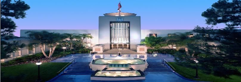
CITY HALL BUILDING
On June 4, 1940, the City of Burbank entered into a contract with the
architectural firm of William Allen and W. George Lutzi for the design of a
new City Hall to replace the existing building located across the street on
the property formerly occupied by the Police Station.
In February 1941 the Federal Works Agency authorized financial
assistance by the Works Projects Administration (WPA) of Southern
California for construction of the new City Hall. However, due to
termination of the WPA by President Roosevelt, the City was required to
complete the construction of City Hall with its own funds.
The building remains a tribute to the craftsmen who built it. Extensive
rare marbles, expensive woods, bronze and ornate decoration were used
to carry out the theme of patriotism and the war effort. Some of the
marble used in the building is Montana rose travertine, Italian levanto,
and Belgian black and gold. The Council Chamber is paneled in
teakwood and the Mayor’s office in semi-bent burl walnut. On February
1912, 1943, Abraham Lincoln’s birthday, the City Hall was dedicated to
“freedom and justice,” symbolic of the nation in which we live.
Three murals were included in the design. Two of the murals were
created by Hugo Ballin. They are “The Four Freedoms,” hanging in the
Council Chamber, and “Burbank Industry,” hanging in the City Hall
rotunda. A third mural, “Justice,” by Bartholomew Mako, is displayed in
the City Attorney’s Office. “The Four Freedoms” mural depicts the
freedoms of speech, religion, freedom from want, and freedom from fear,
as enunciated by President Roosevelt and Winston Churchill in the
Atlantic Charter. “Burbank Industry” features airplanes built in the City,
the motion picture industry, sunny skies, agriculture and family life. When
the Municipal Services Building was built in 1964, this mural was divided
into two parts to allow for the connecting bridge to the annex. The lower
half was donated to the Burbank Historical Society. It was kept in
storage for 37 years and in 2001 the mural was restored and the two
sections were reattached by fine arts conservation experts.
The 2001 City Council-approved Chamber renovation project was
completed with an eye toward comfort and modern technology, while, at
the same time, respecting the original art deco style of Burbank City Hall.
In addition to the Chamber renovation, the project included the
restoration of two murals by Hugo Ballin: "The Four Freedoms" in the
Chamber and "Burbank Industry" in the rotunda.
During the 2001 renovation, the lowered ceiling in the Chamber was
removed. The ceiling was returned to its original height revealing the top
of “The Four Freedoms" mural which had been covered for decades.
Other work included: refinishing the teak paneling on the walls; installing
new carpeting and new theatre-style seating; and, installing new brass
lights similar to the original fixtures.
Many modifications have been made to the City Hall since 1943, but it
still remains a beautiful building and a tribute to the architecture of the
1940’s. The City Hall Building was also placed on the National Register
and California Register of Historical Resources on April 18, 1996.
CITY SEAL
There have been four Seals adopted since 1911. In 1973 a City Seal
Study Committee was appointed to receive and evaluate proposed
designs for a new City Seal to better reflect contemporary values. After
20many suggestions, designs and revisions, a new City Seal was adopted
January 1, 1978, described as:
“The seal of the City, shall consist of a curved banner inscribed with the
words “City of Burbank”, below which shall be inscribed a centered
hexagon containing a depiction of City Hall, which centered hexagon
shall have inscribed tangent to its lower left side another hexagon of
equal size containing a frontal depiction of an airborne aircraft and which
same centered hexagon shall have inscribed tangent to its lower right
side a third hexagon of equal size containing a depiction of a motion
picture film and klieg light, all three (3) of which hexagons shall surmount
an area generally of an inverted triangular shape containing a stylized
depiction of the sun rising over the Verdugo Mountains, and on the
truncated bottom of which triangle shall be inscribed the words
‘Incorporated 1911’.”
CITY FLOWER
CALIFORNIA LILAC (Ceanothus)
The California Lilac is evergreen chaparral foliage which is native to the
Burbank hills. It is a natural erosion-control plant and is often planted for
slope stabilization. The plant comes in a wide variety of colors (from
white through various shades of blue) and sizes (low groundcover to
shrubs), making it suitable for a variety of landscapes.
CITY TREE
CRAPE MYRTLE (Lythraceae Myrtales)
The Crape Myrtle is an extremely popular small tree covered with
profuse bloom in summer. It grows up to 20 feet in height and generally
has several angular trunks covered with smooth, light brown bark that
flakes off to reveal the lighter underbark. The crinkled or crepe flowers
are generally bright pink but are also available in red, lavender, or white.
It requires full sun and average soil.
MEMBERS OF THE CITY COUNCIL
Term Expires
Robert “Bob” Frutos, Mayor ........................................ December 19, 2022
Jess A. Talamantes, Vice Mayor................................. December 19, 2022
Konstantine Anthony ................................................... December 16, 2024
Nick Schultz....................... .......................................... December 16, 2024
Sharon Springer........................................................... December 19, 2022
21OTHER ELECTED OFFICIALS
Zizette Mullins, City Clerk ............................................ December 19, 2022
Krystle Ang Palmer, City Treasurer ............................ December 19, 2022
OFFICIALS APPOINTED BY THE COUNCIL
Justin Hess, City Manager
Amy Albano, City Attorney
OFFICIALS AND EMPLOYEES
APPOINTED BY THE CITY MANAGER
Assistant City Manager Judie Wilke
General Manager, Burbank Water & Power Dawn Roth Lindell
Community Development Director Patrick Prescott
Interim Financial Services Director Jennifer Becker
Fire Chief Eric Garcia
Chief Information Officer Kevin Gray
Library Services Director Elizabeth Goldman
Management Services Director Betsy McClinton
Police Chief Scott LaChasse
Park, Recreation & Community Services Director Marisa Garcia
Public Works Director Ken Berkman
MUNICIPAL CALENDAR
JANUARY 1 - Business taxes due
MAY – Budget and Fee Schedule Adoption for following Fiscal Year
(deadline for Council adoption of Budget is June 30th)
JULY 1 – Beginning of fiscal year, Business licenses due
FIRST TUESDAY AFTER THE FIRST MONDAY IN NOVEMBER (even-
numbered years) - General Municipal Election
SIXTH MONDAY AFTER THE FIRST TUESDAY AFTER THE FIRST
MONDAY IN NOVEMBER - Reorganization of Council/Mayoral Selection
and Induction into office (even-numbered years): Members of City
Council, City Clerk, and City Treasurer.
22SCHEDULE OF PUBLIC MEETINGS
CITY COUNCIL REGULAR – Tuesday evening in the
Council Chamber, City Hall, 275 E.
Olive Ave. at 6:00 p.m. for regular and
joint business. SPECIAL – May be
called as provided by the laws of the
state, by written notice delivered
personally to each member of the
Council.
ART IN PUBLIC PLACES ON CALL – ln the Community Services
COMMITTEE Building, Room 301, Third Floor. 150
N. 3rd St.
BOARD OF BUILDING AND ON CALL – In the Council Chamber,
FIRE CODE APPEALS 275 E. Olive Ave.
BOARD OF LIBRARY REGULAR – 2nd Wednesday of each
TRUSTEES month at Central Library Auditorium,
110 N. Glenoaks Ave. 5:30 p.m.
BURBANK CULTURAL ARTS REGULAR – 2ND Wednesday of each
COMMISSION month in the Community Services
Building, Room 104, 150N. 3rd St.,
9:00 a.m.
BURBANK WATER AND REGULAR – 1st Thursday of each
POWER BOARD month in the BWP Administrative
Building, 164 W. Magnolia Blvd. 5:00
pm.
CIVIL SERVICE BOARD REGULAR – 1st Wednesday of each
month in the Council Chamber, 275 E.
Olive Ave., 4:30 p.m.
HERITAGE COMMISSION REGULAR – 1st Thursday of each
month in the Community Services
Bldg. Room 104,1st Fl., 150 N. 3rd St.,
5:30 p.m.
INFRASTRUCTURE REGULAR – 4th Thursday of each
OVERSIGHT BOARD month in the Council Chamber, 275 E.
Olive Ave., 5:00 p.m.
LANDLORD-TENANT REGULAR – 1st Monday of each
COMMISSION month in the Community Services
Building, Rm., 104 1st Fl., 150 N. 3rd
St., 6:15 p.m.
23You can also read