A Web-based Extension of Google Maps for the Manipulation of Geo-referenced Objects based on Its Satellite Images
←
→
Page content transcription
If your browser does not render page correctly, please read the page content below
A Web-based Extension of Google Maps for the Manipulation of
        Geo-referenced Objects based on Its Satellite Images
                             Dinh Quyen NGUYEN (1), Phuoc TRAN-VINH (2)
                              (1)
                                  Department of Graphics and Image Processing
                              (2)
                                  Department of Geographic Information System
                      University of Information Technology, Ho Chi Minh City, Vietnam
                             Email: ndquyen@uit.edu.vn, phuoc.gis@uit.edu.vn

                                                  Abstract
A web-based application is developed for the manipulation of geo-referenced objects regarding their visual
features based on high-resolution satellite images. In general, this application contains three main
components: a database for the storage of objects description, an engine for the processing of image data
from raster to vector, and a WebUI employing AJAX for interactive objects manipulation. To take the
application into validity, satellite images captured from Google Maps and Google Maps APIs have been
employed for the implementation of the web. The result of the demonstrated application - benefiting by the
availability of GIS, image processing, visualization and Web techniques - opens potential problems for the
investigation into further developments on GIS-based human-centric Web services.

Keywords: Geospatial Web, geodatabase, metadata, KML, satellite images, image object detection.

1. INTRODUCTION
Since its first release in the last decade of the previous century 1 , WWW has nowadays been widely used
and has a strong influence on our everyday lives and activities. Day by day, researchers and developers
have been gradually shifting this whole real world into the virtual environment of Internet, which is defined
as the “second world” [1], appreciating the tremendous development in multimedia and communication
technologies. There, one of the most centralized directions that Microsoft, Google, and many other
computing and communication corporations focus on is the development of Web frameworks and
applications dealing with the solutions for geotagged information management and usages.
     The advance in multimedia and communication technology brings satellite and aerial images, street and
building videos, as well as many other 2D and 3D visualization objects, both physically and synthetically,
into the WWW. Various systems have been developed to present such concept; among them, Google Maps
[2] can be considered as one of the most well-known Web maps that provides tools and applications for the
manipulation and usage of geo-referenced data. However, unlike other traditional GIS applications which
cover the broad sense of geospatial data and its attributes, Google Maps focuses mainly on the validation of
multimedia over Internet, while using GIS data provided by other companies (e.g. NAVTEQTM and
Maplink/Tele Atlas). In this regard, what Google aims at can be referred to as (1) the deployment of
advanced technologies for (2) the use of popular customers concerning its human-centric interaction issues.
     The more informative and flexible the tools support, the more beneficial the providers will gain. To
attract many end-users as well as developers, Google has been providing not only various Web services but
also many tools for the manipulation and extension of their frameworks and applications. In the case of
Google Maps, Google Map Maker [3] has been introduced as a manual tool with options for the
manipulation of geo-referenced objects (roads, regions, and points of interest) based on its satellite images.
The tool produces applicable results; however, as a manual tool, it would not perfectly support the end-
users. Consequently, work on the development of automatic objects detection would be useful for the
improvement of the tool. In such narrow sense of image processing for GIS, automatic bridge detection [4],
road detection [5-6], tree detection [7], together with building detection [8-10], are some amongst many
other interesting topics in GI Science and Remote Sensing that can be further investigated for the extension
of Google Maps and other mapping systems.

1
 World Wide Web (WWW) was created in 1989 by Tim Berners-Lee, working at the European Organization for Nuclear
Research (CERN) in Geneva, Switzerland, and released in 1992.

                                                      1
In our current experiments, building and house detection in high-resolution satellite images of Google
Maps are taken into account. However, detail algorithm for objects detection is not the focus of this paper.
Instead, we concentrate on the development of the whole web-based application, where objects detection is
one of its three main tasks. In general, the application contains the following components: a database for
the storage of objects description, an engine for the processing of image data from raster to vector, and a
WebUI (web user interface) employing AJAX [11] for interactive objects manipulation.
Our web-based application is developed following the criteria and trend of geospatial Web provided
within the last few years. Thus, in section 2, we will present related work and concepts about web mapping
and geospatial Web services. Following it, in section 3, detail concepts and explanations for our web-based
application are provided. Section 4 continues with demonstrated results and discussions which open further
development issues. Finally, we conclude the paper in section 5.
2. BACKGROUND
2.1 Geospatial Web and the Attraction of Google Maps
Originally up to the late 1990s, when GIS data was mostly based on large computers and used to maintain
internal records, GIS software was a stand-alone product. However, with the development of Internet and
WWW, and the trend of social networks, geospatial Web has emerged and gradually become more and
more popular with a strong consideration from both developers and customers. Many geospatial Web
services and APIs have been developing based on the core systems provided by both commercial and open-
source GIS companies.
The most well-known commercial GIS company is ESRI which provides a wide range of applications
from desktop-based applications to web-based services. However, though getting a huge amount of
customers for its desktop products (i.e. ArcView, ArcEditor, and ArcInfo) with nearly 80 percent of GIS
users worldwide from all professions [12], ArcIMS – the Web map server of ESRI [13] – has still not been
well-popularized in the WWW communities. The reason is that most of GIS data maintained by ESRI and
other traditional GIS releases seem to be so domain-focused (i.e. GIS-focused) that they are somehow
unfamiliar to many non-GIS-expert users. Additionally, interface and usability studies as well as network
infrastructures are also the matters for the deployment of such GIS webs. To slightly tackle the problems,
open-source geospatial webs [14] have been taken into account, providing chances for researchers and
practitioners to advance the availability of the extensible databases, programming languages, and web-
based libraries. But, once again, open-source GIS are not secure enough or well-developed enough for the
choice of the current well-known Web maps.
Among the most well-known Web maps (Microsoft Live Maps - http://maps.live.com, Yahoo! Maps -
http://maps.yahoo.com, MapQuest - http://www.mapquest.com, Multimap - http://www.multimap.com,
etc.), Google Maps [2] is evaluated as the most usable one in United Kingdom [15][16]. This might also be
similar to Vietnam and many other places in the world. In Vietnam, the current Web map that provides
most geo-referenced information is Google Maps. With its Map Maker [3], Google Maps has attracted
more and more Vietnamese Internet users [17], and it will promisingly be the most popular web mapping
service when being fully deployed. Furthermore, with its advantage in providing APIs for the integrated
websites and extensions (examples can be seen through Wikimapia - http://www.wikimapia.com,
DiaDiem - http://diadiem.com, etc.), Google Maps can be considered as the most suitable choice for many
geospatial web customers and developers.
As what has been done with GMapCreator and MapTube (http://www.maptube.org) [18] at the
Center for Advanced Spatial Analysis, University College London, we investigate into the exploitation of
Google Maps for the development of a web-based application. The goal of our development is to reach the
concept of Geographic Information’s Renaissance [19][20], where GIS is no longer considered as a
working domain for geo-focused data, but rather a virtual and mirror environment for the creation,
manipulation, analysis, and retrieval of spatial and temporal data in close connection to social networks,
social bookmarks, blogs, as well as other geospatial Web data; blurring the gaps between geo-referenced
information and the WWW hyperlinks. This would also adapt the requirement of current trends in
2geovisualization and geovisual analytics researches, focusing on the analysis, visualization, and
presentation of multidimensional geospatial and temporal data, giving chances for users to interactively and
freely access geotagged information without considering the complex structures of geodata [21].
We will return to the detail discussion about Google Maps as well as our development in sections 3 and
4. For the remaining part of this section, we will talk about geomatics standards as the fundamentals for the
development of any GIS-based application at this very moment.
2.2 Geomatics Standards for Geospatial Web
Historically, GI systems have been developed by a great number of companies and research groups,
resulting in a variety of geospatial applications and products with a lot of geospatial data structures, file
formats and database systems. To adapt their increasing existence over networks, GIS products would be
portable and interoperable. As a result, work on the development of standards and specifications for the
discovery, access, integration, analysis, exploitation and visualization of multiple geodata sources, as well
as sensor-derived information and geoprocessing capabilities over networks have been taken into account.
Since 1994, OGC (Open Geospatial Consortium) [22] and ISO/TC211 [23] have been involving in the
creation of standards and recommendations for such geospatial information and services. The results have
been applying in all current GIS products, from commercial GIS (e.g. ESRI, Mapinfo -
http://www.mapinfo.com, Autodesk – http://www.autodesk.com) to open source GIS (through Open
Source Geospatial Foundation - https://www.osgeo.org/) and social web mapping services (Google Maps,
Live Maps, Yahoo! Maps, etc.).
ISO Parts, PAS
Base Standards Extensions
ISO/
TC211
(OGC resolution) reference amendment (ISO resolution)
Essential Abstract
OGC Model consensus Specification
RFP process amendment
More or less Implementation
same Specification
people
involved development revision
Market Implementation
(Services)
Figure 1. GI standardization and interoperability – © Open Geospatial Consortium.
Fig. 1 illustrates the concept of standardization and interoperability in GIS products from research and
development to the market. Following that point of view, in order to implement a geospatial web, we have
to follow standards and specifications provided by OGC. In this case, there are two main issues dealing
with the development of our web-based geo-referenced application: the study into geospatial data and
database specifications, and the concepts of OCG Web Services, in close connection to the release of
Google Maps. Based on it, detailed model of our application is developed, as will be presented in the next
sections.
For data management, the most considerable specification is the Simple Features Interface Standard
[24] with Common Architecture and Standard SQL Implementation. It provides a well-defined and
common way for applications to store and access feature data in relational or object-relational databases, so
3that the data can be used to support other applications through a common feature model, data store and
information access interface. Based on it, geospatial features with vector data elements such as points, lines
and polygons are defined in geospatial DBMSs (e.g., ArcSDE - http://www.esri.com/software/
arcgis/arcsde/, Oracle Spatial - http://www.oracle.com/technology/products/spatial/, PostGIS -
http://postgis.refractions.net/) as well as other geodatabase products.
Since data are to be portable to Google Maps and other GIS products, XML-based specifications for
geospatial data manipulation are taken into account. There, GML (Geography Markup Language) [25] is
the core for geospatial data interchange on Internet, and KML (Keyhole Markup Language) [26] after
Google Earth is used for Google Maps and its relevant products, as in our case. As an XML language
focused on geographic visualization, including annotation of maps and images, KML is complementary to
most of the key existing OGC standards including GML and other OGC Web Services.
In all nowadays web mapping systems, the two prominent OGC Web Services are WFS (Web Feature
Service) [27] and WMS (Web Map Service) [28], where WFS is the specification dealing with vector
(feature) geospatial data, while WMS concerns raster data in form of map images. Based on them, further
developments, such as Web3D Earth (http://www.web3d.org/x3d-earth/) with Web Viewpoint Service as
extension of WMS and WFS for 3D viewpoint-oriented request and presentation, or 3DCity Models
(http://www.3dgeo.de/) with the transformation of BIM (building information model) and CAD
(computer aided design) data into GIS, and other Geowebs, are on-researching to make what is called
“second world” becomes reality.
3. THE PROPOSED GEOSPATIAL WEB-BASED APPLICATION
3.1 Overview of the Proposed Application
Our goal is to establish a geospatial Web which is based on Google Maps and follows the concepts of web
mapping for the manipulation and presentation of geo-referenced objects regarding relevant high-resolution
satellite images. In general, this web-based application contains the following three main components: a
database for the storage of objects description, an engine for the processing of image data from raster to
vector, and a WebUI employing AJAX for interactive objects manipulation. The overall of this application
structure is presented in Fig. 2.
AJAX
Object
Detection
WebUI
APIs
server-side
DBMS client-side
Google
geodatabase Maps
Figure 2. Overall structure of the proposed web-based application.
The web application is mainly server-side developed, but its client-side is also taken into account for
the requirement of interactive browsing. As a web map server, the application deals with the organization,
processing, and storage of geospatial data, in close connection to geodatabases and other web services. To
support its clients, the application employs AJAX for the manipulation of HTTPs data. In any case, the
development of our application is based on standard specifications provided by OGC and W3C (World
Wide Web Consortium - http://www.w3.org/) and on the implementation of standards and services
supported by other providers. Here, we do not develop a new web mapping service, but use a relevant one
4provided by Google Maps through its APIs. By doing so, we do not need to organize and store the whole
geodatabase with a huge and expensive image collections.
Instead, our data are stored in a geospatial database as defined in subsection 3.2. Furthermore, it would
also easier for us to latterly improve the tool if needed, without concerning the effect of the tool back to
Google Maps. This makes our application flexible, comparing to the silent use of Google Maps as an
integrated service in WWW. To represent this concept, we have been developing a module for the detection
of visual objects based on the satellite images of Google Maps. Similarly, other processing components are
expected to be developed in our future work. The more detailed ideas about this interactive raster to vector
image object component will be mentioned in subsection 3.3.
The combination of server-side processing and client-side manipulating on visual objects and maps are
validated through what we call Web user interface (WebUI). In subsection 3.4 we will end our proposed
application with its related concepts and issues.
3.2 Data Management Component
As presented in the previous subsection, in order to store the geospatial feature data without accessing to
Google Maps data repository, we created a separate geodatabase in this application. Following geospatial
data structures developed in current geo-DBMSs, our spatial database stores objects dealing with space
information, including points, lines and polygons. This feature data follow OGC Simple Feature Interface
Standard [24]. This was due to the need of keeping geo-object created in the image processing component,
as well as the need of manipulating its structure (for example, to 3D) in the future. Since the application is
developed after Google Maps, all the vector data are to associate with the World Geodetic System 1984
(WGS84) datum [29].
The benefit of using geospatial databases is that all geographic data could be centrally stored and
managed in one depository, instead of archiving in separate spatial or attribute data shape files. As data is
stored in relational databases, all interaction with the server is through the execution of commands in
Structured Query Language (SQL) and we can make use of SQL to generate complex queries. Also, a
database's client-server environment can support multiple concurrent requests, i.e. multiple users can
access, edit the contents simultaneously without any conflicts.
To store and manage data in database, we use a DBMS. When users change the map view in Google
Maps, the web application requests encoded data that represent for geometry from DBMS according to the
current geographic location. Those data are extracted from database tables and sent back to the web
application. Then, a module will decode those data and use Google mapping APIs to show on Google
Maps. If users create or edit geometric objects, another module in the web application will encode the
objects and send encoded data to the DBMS.
Furthermore, when users query data, metadata will help them decide whether the resource they found is
suitable for their purposes. Metadata of geospatial data will be stored as XML data and follows the ISO
19115 metadata standard [30] implementing by the ISO 19139 XML schema [31].
These days, there are many DBMSs designed to supply users with XML features. That equipment
helps us to express visualized data in Google Maps and maybe also in three-dimensional Earth browsers
(e.g. Google Earth) by exporting visualized data as KML format [26] with less effort. And for the
application to be able to exchange information, GML [25] was chosen. It is becoming increasingly clear
that GI systems support importing GML data into their geodatabases. This means after the process of
analysis of Google satellite images, geospatial data can be used in other GIS applications with various
purposes.
3.3 Interactive Object Detection Component
The difference between our first developed application and a normal integrated Google Maps is the support
of a semi-auto detection tool for the manipulation of visual objects based on its high-resolution satellite
images, instead of a manual tool like the Map Maker. To take such idea into reality, there are two
requirements taken into account: the easy manipulation and the accurateness. To support it, we design the
tool with options for users to simply select an area, and then the system will semi-automatically detect the
5objects within that region. In addition, by doing so, our WebUI also helps users to modify the object’s
boundary in case the result is not completely accurate.
Generally, working process is as follows: (1) an image is captured through options provided by
WebUI, (2) the image is then segmented to detect the promising object region, and (3) a set of vertexes and
edges is created based on it and represented on WebUI so that the user can adjust it if needed.
Here, the centralized task that we extremely focus on is the image segmentation process, as it
completely affects the result as well as the flexible use of the tool. Literately, there are a lot of image
segmentation algorithms, each of which has advantages and disadvantages applying in different application
domains [32]. However, the detailed analysis of our algorithm is not the focus of this paper. In short, we
inherit the concepts of image features (color, texture, shape) in Blobworld system [33] and adapt them to
the clustering algorithm provided by Comaniciu and Meer in their Meanshift [34], where color features of
image and the coordinate of pixel are thoroughly analyzed for the detection of image regions.
Finally, we advance edge detection methods for the utilization of object’s shape. Since the normal form
of a building is rectangle-based polygon, line detection algorithms, such as Hough-based transform [8], can
be used for the reconstruction of edges and building vertexes. The final result will be temporarily saved and
displayed on WebUI for further confirmation and modification by the user. After all, the result will be
saved on DB through DBMS.
3.4 Geospatial Web User Interface based on Google Maps
The last component mentioned in our development is the web interface. Currently, there are a lot of web
mapping platforms that can be used for the development of a new web mapping application (e.g.
MapServer - http://mapserver.gis.umn.edu/, CartoWeb - http://www.cartoweb.org/, OpenLayers -
http://www.openlayers.org/, degree - http://www.deegree.org/, etc.). However, we do not exploit them
for our development, but just employ Google Maps and its supported APIs.
As a web-based application, our application includes two parts, the server and the client. While data
management component and image processing component run at server side, only the web interface runs at
client side. Users can choose the geo-referenced object they want to manipulate through satellite images
provided by Google. The object’s image is then sent to the image processing component, and the
processing result will be shown back on-the-fly to the user if he/she wants to supervise the process. When
the object features are successfully extracted from the image, they will be passed along with the object geo-
coordinate to the data management component, where they are stored and indexed for further references
and can be displayed on the map when the user is viewing that object again.
The web interface takes heavy use of Google Maps APIs to interact with users. The APIs provide some
predefined and customizable layers that can be shown over the map as web components. Those layers are
bounded to a geographic coordinate and can be adjusted to describe geospatial object. Besides information
showing via layers, Google Map APIs also support monitoring keyboard and mouse events on the map,
which can be used for the creation of a powerful web interface.
When a client got information from the user, it will connect to the server using AJAX and hand over
the necessary information to other components of the application. As the image is retrieved from Google
Maps, we implement that such information is sent to the server in plain text format, regarding which image
and which portion of that image covering the object, using HTTP POST method.
4. FIRST RESULTS AND DISCUSSIONS
4.1 First Results
Following the proposed concepts, we have been developing the application as follows: The application
consists of three separate components and thus each component has its own developing environment. The
data management component uses Microsoft SQL Server, a relational database management system. The
underneath image processing component is written in C#. And the Web user interface component is built
on ASP.NET, a technology developed by Microsoft to create web sites and applications.
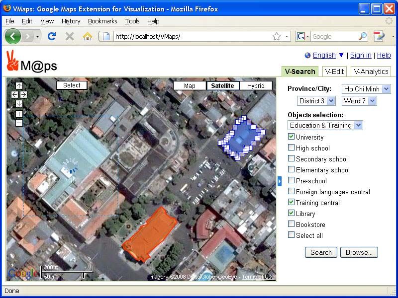
6The location we desire to pick out to experiment with the application is Ho Chi Minh City (HCMC),
the largest city in Vietnam. With acceptable satellite images provided by Google Maps for HCMC, one can
get the result as presented in Fig. 3. In this example, the user tries to detect some different objects based on
the satellite images. On the left side, an object is in progress of being detected; and on the right side, two
objects are created. They are concurrently being processed; however, only one of them is specified for the
adjustment at a time (in this example, the upper one on the right side is specified).
Figure 3. Snapshot of the client-side WebUI for Ho Chi Minh City at the coordinates [10.7773, 106.7034].
The implemented image segmentation algorithm in the image processing component is pretty fast, in
comparison to many others (for instance, the BlobWorld and the BlobContours [33]). This satisfies the
requirement of an interactive WebUI. Further on, we are also developing other techniques for a
comprehensible interface so that the users can better access and manage the geo-referenced information.
4.2 Discussions
The fact that a web-based application is developed as an extension of Google Maps makes the application
manageable and upgradeable without strongly caring about how Google Maps structures its database.
However, such development requires a great effort in developing a database that adapts to the structure of a
geo-referenced system (i.e. following the interoperable standards and specifications) while keeping its own
structure in a suitable way. Besides, since we exploit Google Maps APIs to get its images as well as to
show visual map elements on the WebUI, further problems may emerge if Google Maps changes its images
or APIs (it is to notice that at this moment Google Maps satellite images for HCMC are quite old and not at
the highest resolution). Object detection algorithm is also affected when images changed and improvements
are required. Another problem is Google is creating maps for HCMC with visual interface that show many
buildings, what we should do is not just to detect the buildings, but also to provide visual features and
interface for geotagged information creation, analysis, and representation. In such manner, we are
7investigating into a more robust interface with HCI techniques assisting users in easier accessing and
finding their desired information. (As in Fig. 3, a simple interface with options for buildings and regions
selection in HCMC has been developing).
As HCMC is a crowded but not very neatly-built city, its buildings are not unique. Densely built-up
areas make the detection of objects more complex. This therefore requires the investigation into a suitable
object detection algorithm. Though having extended Meanshift [34], a quite fast algorithm, for segmenting
objects in a region, we still need to improve it (e.g., including the texture features) for a more robust
algorithm. Besides, it would be better if we detect objects in a simpler way than what we have done so far
(e.g. by clicking on an image region to detect the object using a region-growing segmentation algorithm).
Finally, we plan to improve the algorithm to reconstruct the building’s polygon with a faster line
reconstruction technique instead of the slow Hough transform.
5. CONCLUSION AND FUTURE WORK
In this paper, we have introduced a web-based application as an extension of Google Maps for the creation
and manipulation of geo-referenced objects regarding their associated high-resolution satellite images. The
application loads images from Google Maps as well as relevant data (which are vector-based objects and
other geo-tagged information, if existed) in application database and show them altogether on the WebUI,
following user’s requests. The advantage of this application is to provide tools for end-users to semi-
automatically identify geo-referenced objects with the support of an underneath image processing
component before adding them to the application database. In this regard, the application has been
independently developed without caring about Google Maps database though using its images. This makes
the application manageable and extensible for future development of a flexible interactive geospatial web.
Though establishing the overall structure of the application as well as getting some results as
demonstrated, the application is just at its first implementation steps. Future work includes many other
tasks. Firstly, we need to complete the database and relevant data structures for the application, in close
connection to the interoperable standards and specifications provided by OGC. Secondly, other objects
detections (i.e. not only buildings) are taken into account for the identification and management of all
important 2D visual objects based on Google Maps high-resolution satellite images. The development of
3D buildings (3D city models) for Ho Chi Minh City is also a next focus. They are altogether considered
for the development of a geospatial web, in its integration with social geodata (GeoRSS, bookmarks, blogs,
etc.). Lastly, to support end-users in comprehending the existing data, new analytical and visualization
techniques concerning human-center interaction issues are to be developed for the fulfillment of the
application.
6. ACKNOWLEDGMENTS
This work was supported by Vietnam National University – Ho Chi Minh City, Project No. B2008-82-05.
The authors also would like to acknowledge NGUYEN Hai Son, TA Anh Tuan, MAI HOANG Hoai
Thuong, and PHAM NGUYEN Truong An for the valuable implementation of the demonstrated web-based
application.
REFERENCES
[1] Doug Zuckerman, “Shaping Technology - The Next Generation,” Keynote Talk at IEEE International Conference on
Research, Innovation and Vision for the Future 2008 (RIVF’08), Ho Chi Minh City, Vietnam, July 2008.
[2] Google Maps, http://maps.google.com
[3] Google Map Maker, http://www.google.com/mapmaker
[4] Yu Han, Hong Zheng, Qiong Cao, Yang Wang, “An Effective Method for Bridge Detection from Satellite Imagery”, In
2nd IEEE Conference on Industrial Electronics and Applications 2007 (ICIEA 2007), pp. 2753-2757, Harbin, China,
May 2007.
[5] Jia Cheng-Li, Ji Ke-Feng, Jiang Yong-Mei, Kuang Gang-Yao, “Road extraction from high-resolution SAR imagery
using Hough transform,” In Proc. IEEE International Geoscience and Remote Sensing Symposium 2005 (IGARSS’05),
Vol. 1, pp. 336-339, July 2005.
8[6] Emmanuel Christophe, Jordi Inglada, “Robust Road Extraction for High Resolution Satellite Images”, In Proc. IEEE
International Conference on Image Processing 2007 (ICIP 2007), Vol. 5, pp. 437-440, San Antonio, Texas, USA, Sept.
2007.
[7] John Secord, Avideh Zakhor, “Tree Detection in Urban Regions Using Aerial Lidar and Image Data,” In IEEE
Geoscience and Remote Sensing Letters (GRSL), Vol. 4, No. 2, pp. 196-200, April 2007.
[8] Martin Persson, Mats Sandvall, and Tom Duckett, “Automatic Building Detection from Aerial Images for Mobile Robot
Mapping,” In Proc. IEEE International Symposium on Computational Intelligence in Robotics and Automation, 2005
(CIRA 2005), pp. 273-278, Espoo, Finland, June 2005.
[9] Xiaoying Jin, Curt H. Davis, “Automated Building Extraction from High-Resolution Satellite Imagery in Urban Areas
Using Structural, Contextual, and Spectral Information,” EURASIP Journal on Applied Signal Processing Vol. 2005,
Issue 14, pp. 2196–2206, 2005.
[10] Jinhui Hu, Suya You, Ulrich Neumann, “Integrating LiDAR, Aerial Image and Ground Images for Complete Urban
Building Modeling,” In Proc. 3rd International Symposium on 3D Data Processing, Visualization, and Transmission
(3DPVT'06), pp. 184-191, Chapel Hill, NC, USA, June 2006.
[11] AJAX at the Open Directory Project, http://dmoz.org/Computers/Programming/Languages/JavaScript/AJAX/
[12] GIS Salary Survey, GISJobs.com, http://www.gisjobs.com/survey/responses.jsp?countryLoc=all&sal=N, accessed
on Sept 08, 2008.
[13] ArcIMS – Publish Maps, Data, and Metadata on the Web, http://www.esri.com/software/arcgis/arcims/
[14] Paul Ramsey, “The State of Open Source GIS,” Free and Open Source Software for Geospatial 2007 (FOSS4G 2007),
Victoria, Canada, Sept 2007.
[15] Artemis Skarlatidou, Muki Haklay, “Public Web Mapping: Preliminary Usability Evaluation,” 14th Annual GIS
Research UK Conference (GISRUK 2006), Nottingham, UK, April 2006.
[16] Annu-Maaria Nivala, Stephen Brewster, L. Tiina Sarjakoski, “Usability Evaluation of Web Mapping Sites,” The
Cartographic Journal, Vol. 45, No. 2, pp. 129-138, May 2008.
[17] Google to Pay More Attention to Vietnamese Market, SGGP English Edition, http://www.saigon-
gpdaily.com.vn/Special_report/2008/8/64798/, 21 Aug 2008.
[18] Andrew Hudson-Smith et al., “Public Domain GIS, Mapping & Imaging Using Web-based Services”, CASA Working
Paper 120, London, Sept 2007.
[19] A. Scharl, K. Tochtermann (Eds.) The Geospatial Web - How Geobrowsers, Social Software and the Web 2.0 are
Shaping the Network Society. Springer, London. 2007.
[20] Andrew Hudson-Smith, Andrew Crooks, “The Renaissance of Geographic Information: Neogeography, Gaming and
Second Life,” CASA Working Paper 142, London, August 2008.
[21] Gennady Andrienko, Natalia Andrienko, Piotr Jankowski, Menno-Jan Kraak, Daniel Keim, Alan MacEachren, Stefan
Wrobel, “Geovisual Analytics for Spatial Decision Support. Setting the Research Agenda,” International Journal of
Geographical Information Science, v.21 (8), pp. 839-857, Sept 2007.
[22] Open Geospatial Consortium, http://www.opengeospatial.org/
[23] ISO/TC 211 Geographic Information/Geomatics, http://www.isotc211.org/
[24] OpenGIS Simple Features Interface Standard, http://www.opengeospatial.org/standards/sfa
[25] OpenGIS Geography Markup Language Encoding Standard, http://www.opengeospatial.org/standards/gml
[26] KML – OpenGIS Implementation Standard, http://www.opengeospatial.org/standards/kml
[27] OpenGIS Web Feature Service Interface Standard, http://www.opengeospatial.org/standards/wfs
[28] OpenGIS Web Map Service Interface Standard, http://www.opengeospatial.org/standards/wms
[29] NIMA Technical Report TR8350.2. Department of Defense World Geodetic System 1984, Its Definition and
Relationships With Local Geodetic Systems. Third Edition, National Geospatial-Intelligence Agency, last update June
2004.
[30] ISO 19115:2003, Geographic information -- Metadata.
[31] ISO/TS 19139:2007, Geographic information -- Metadata -- XML schema implementation.
[32] L. Lucchese, S. K. Mitra, “Color Image Segmentation: A State-of-the-Art Survey.” In Proc. of the Indian National
Science Academy. 67(2): 207-221, March 2001.
[33] Thomas Vogel, Dinh Quyen Nguyen, Jana Dittmann, “BlobContours: Adapting Blobworld for Supervised Color- and
Texture-Based Image Segmentation,” In Proc. SPIE Electronic Imaging - Multimedia Content Analysis, Management,
and Retrieval 2006, vol. 6073, pp. 60730I-1 – 60730I-12, San Jose, CA (USA), Jan 2006.
[34] Dorin Comaniciu, Peter Meer, “Mean Shift: A Robust Approach Toward Feature Space Analysis,” IEEE Transactions
on Pattern Analysis and Machine Intelligence, Vol. 24, No. 5, pp.603-619, May 2002.
9You can also read