Web Map Tile Service Developer Guide - Cloud Services | August 2013
←
→
Page content transcription
If your browser does not render page correctly, please read the page content below
Web Map Tile Service Developer
            Guide
      Cloud Services | August 2013
Web Map Tile Service Developer Guide | 2
Table of Contents
List of Figures.................................................................................................................................. 3
List of Tables ................................................................................................................................... 4
1 Introduction ................................................................................................................................ 5
1.1 About This Document ............................................................................................................ 5
1.2 Targeted Audience ................................................................................................................ 5
1.3 What is WMTS? .................................................................................................................... 5
1.4 References ............................................................................................................................ 5
2 Geography Markup Language (GML)......................................................................................... 6
2.1 Introduction to GML ............................................................................................................... 6
2.2 Overview of GML Schema ..................................................................................................... 6
2.3 GML Schema Features.......................................................................................................... 7
2.3.1 AbstractFeatureType ................................................................................................................ 7
2.3.2 AbstractFeature ........................................................................................................................ 7
2.4 Overview ............................................................................................................................... 7
2.4.1 Dictionary Schema.................................................................................................................... 8
3 Web Map Tile Service (WMTS) ................................................................................................. 12
3.1 Introduction to WMTS .......................................................................................................... 12
3.2 Advantages of WMTS .......................................................................................................... 12
3.3 WMTS Client-Server Architecture ........................................................................................ 13
3.4 WMTS Service Details ......................................................................................................... 13
3.5 Basic Service Elements ....................................................................................................... 14
3.5.1 HTTP Request ........................................................................................................................ 14
3.5.2 HTTP response ...................................................................................................................... 15
3.5.3 Request Parameters ............................................................................................................... 16
3.5.4 Request Parameter Rules ....................................................................................................... 17
3.6 Integration Procedure .......................................................................................................... 18
3.7 Service Exceptions .............................................................................................................. 21
3.8 WMTS Layers...................................................................................................................... 22
3.9 API Reference ..................................................................................................................... 22
4 Building a Tile Cache ............................................................................................................... 23
4.1 Introduction ......................................................................................................................... 23
4.2 Building a Tile Cache from DigitalGlobe WMTS ................................................................... 23
4.2.1 Step 1: Build Tile Cache .......................................................................................................... 23
4.2.2 Step 2: GetTile Request .......................................................................................................... 23
4.2.3 Step 3: Caching GetTile Response .......................................................................................... 23
4.3 Updating Tile Cache ............................................................................................................ 24
4.4 World-File Generation.......................................................................................................... 24
Glossary ......................................................................................................................................... 25
Index .............................................................................................................................................. 26
WEB MAP TILE SERVICE – DEVELOPER GUIDE
Copyright © 2013 DigitalGlobe Inc. Proprietary & ConfidentialWeb Map Tile Service Developer Guide | 3
List of Figures
Figure 3.1 A Typical Structure of a DGCS-WMTS Application................................................................................ 12
Figure 3.2 WMTS Service Divided into Tiles ......................................................................................................... 12
Figure 3.3 Sample WMTS Client-Server Application.............................................................................................. 13
Figure 3.4 Sample HTTP Post Request/Response ................................................................................................ 15
Figure 4.1 Tile Cache Response Image ................................................................................................................ 24
WEB MAP TILE SERVICE – DEVELOPER GUIDE
Copyright © 2013 DigitalGlobe Inc. Proprietary & ConfidentialWeb Map Tile Service Developer Guide | 4
List of Tables
Table 3.1 A General Get Request ......................................................................................................................... 14
Table 3.2 Reserved Characters in HTTP GET Query ............................................................................................ 14
Table 3.3 Values for OutputFormat Attribute ......................................................................................................... 16
Table 3.4 Understanding URL Parameters for WMTS GetCapabilities Request ...................................................... 18
Table 3.5 GetTile Request Parameters ................................................................................................................. 20
Table 3.6 WMTS Layers....................................................................................................................................... 22
Table 3.7 Understanding URL Parameters for WMTS GetCapabilities ................................................................... 22
WEB MAP TILE SERVICE – DEVELOPER GUIDE
Copyright © 2013 DigitalGlobe Inc. Proprietary & ConfidentialWeb Map Tile Service Developer Guide | 5
1 Introduction
1.1 About This Document
This document covers the concepts of Web Map Tile Service (WMTS), Open Geospatial Consortium (OGC)
standards for WMTS, capabilities of WMTS and ways to integrate DigitalGlobe Cloud Services (DGCS)-WMTS in
GIS-based custom application development.
1.2 Targeted Audience
This document is targeted to help developers of GIS-based custom applications. Developers new to WMTS can read
about the DGCS-WMTS framework, capabilities, integration procedures and development best-practices to design
methods for creating innovative world-class GIS applications.
1.3 What is WMTS?
The OGC WMTS Implementation Standard provides an interface to serve digital maps using predefined image tiles.
The WMTS standard complements the existing Web Map Service (WMS) standard of the OGC. Imagery is always
returned in relation to the world-wide grid and the grid is unique per projection. This forces the clients to mosaic the
tiles obtained from the server and then clip the set of tiles into a final image.
Definition of a Tile
The tile resource is generally a rectangular image containing cartographic data. Alternatively, this resource might be a
non-image representation of the tile such as a description of the tile or a link to the actual image. For example, the tile
resource could be a KML document used in a super-overlay, or a tile metadata document. When returning an image
tile, a full single tile will always be returned. Also, the background pixels of a tile should be transparent when possible
so that the client can overlay the tiles on top of other map data (possibly other tiles).
1.4 References
http://www.opengeospatial.org/standards
http://en.wikipedia.org/wiki/GIS#OGC_standards
http://en.wikipedia.org/wiki/Geography_Markup_Language
WEB MAP TILE SERVICE – DEVELOPER GUIDE
Copyright © 2013 DigitalGlobe Inc. Proprietary & ConfidentialWeb Map Tile Service Developer Guide | 6
2 Geography Markup Language (GML)
2.1 Introduction to GML
The Geography Markup Language (GML) is the XML code used by the OGC to express geographical features. GML
serves as a modeling language for geographic systems as well as an open interchange format for geographic
transactions on the Internet. Note that the concept of feature in GML is a very general one and includes not only
conventional "vector" or discrete objects, but also coverages and sensor data. The ability to integrate all forms of
geographic information is key to the utility of GML.
GML was conceived and evolved for a variety of reasons, the most important reasons being:
To provide a language for expressing geographic entities – to create application specific geographic
vocabularies.
To enable the encoding of geographic information consistent with these vocabularies.
To support geospatial queries and transactions across the Internet.
GML is feature-centric. Features are entities – things that describe aspects of the real world from the perspective of a
particular application community – whether circumscribed by geography or function or both. GML vocabularies are
created by communities of interest. These vocabularies are called GML Application Schemas. If you look at such an
Application Schema you will find real world objects like Buildings, Roads, Buoys, Navigation Aids, Airline Flight Paths,
Vehicles and Railway Switches. Each such object is defined in the schema by listing its properties. For example, a
Building might be described by:
40
Note that the Building (feature) has two properties, namely height and footprint. The height property in this case has
an integer value (number of stories), while the footprint property has a Polygon (shape) for a value.
GML application schemas can be the basis of standards themselves – such as S57GML, cityGML, geoRSS GML and
AIXM, or they can be informal creations for only a very small community. Which is the case is up to the community.
GML application schemas should NOT be confused with GML profiles. A GML profile is a subset of GML, defined
usually by the subset tool (part of the GML specification), consisting of selected element, attribute and type
declarations and all dependent components from the GML core schemas (the schemas defined by the GML
specification). Application schemas can be built on GML profiles. Some GML profiles are also specifications and this
includes the GML Simple Features Profile, the Point Profile, the GML Profile for GMLJP2 and the GML Profile for
GeoRSS.
GML was developed to support geographic requests and transactions and this usage predates the WCS developed
for this purpose. When a user sends a request for geographic data – e.g. “find all water wells within this county” –
there must be a way to express “water well”, “county” and the “geometric extend of the county”. In WCS, GML is used
for this purpose. When the user wants to send a transaction such as “change the shape of the Holmes River to the
following …” they need a way to express the river’s geometry; GML provides this mechanism in the WCS.
2.2 Overview of GML Schema
GML specifies XML encodings of a number of the conceptual classes defined in the ISO 19100 series of International
Standards and the OpenGIS Abstract Specification in conformance with these standards and specifications.
In many cases, the mapping from the conceptual classes to XML is straightforward, while in some cases the mapping
is more complex.
In addition, GML provides XML encodings for additional concepts not yet modeled in the ISO 19100 series of
International Standards or the OpenGIS Abstract Specification. Examples include moving objects, simple
observations or value objects. Additional conceptual classes corresponding to these extensions are also specified in
Annex D.
WEB MAP TILE SERVICE – DEVELOPER GUIDE
Copyright © 2013 DigitalGlobe Inc. Proprietary & ConfidentialWeb Map Tile Service Developer Guide | 7 The GML schema comprises the components (XML elements, attributes, simple types, complex types, attribute groups, groups, etc.) that are described in this International Standard. The XML encoding conforms to ISO 19118. 2.3 GML Schema Features A GML feature is a feature encoded using GML. Examples include a road, a river, a person, a vehicle, an administrative area, or an event. The feature schema provides a framework for the creation of GML features and feature collections. 2.3.1 ABSTRACTFEATURETYPE The basic feature model is given by the gml:AbstractFeatureType, defined in the schema as follows: The content model for gml:AbstractFeatureType adds two specific properties suitable for geographic features to the content model defined in gml:AbstractGMLType. The value of the gml:boundedBy property describes an envelope that encloses the entire feature instance, and is primarily useful for supporting rapid searching for features that occur in a particular location. The value of the gml:location property describes the extent, position or relative location of the feature. gml:location is deprecated as part of the standard content model of gml:AbstractFeatureType. 2.3.2 ABSTRACTFEATURE The element gml:AbstractFeature is declared as follows: This abstract element serves as the head of a substitution group which may contain any elements whose content model is derived from gml:AbstractFeatureType. This may be used as a variable in the construction of content models. gml:AbstractFeature may be thought of as anything that is a GML feature and may be used to define variables or templates in which the value of a GML property is “any feature”. This occurs in particular in a GML feature collection where the feature member properties contain one or multiple copies of gml:AbstractFeature respectively. The Other features which are used are boundedBy, BoundingShapeType, EnvelopeWithTimePeriod, EnvelopeWithTimePeriodType, locationName, locationReference,FeaturePropertyType, FeatureArrayPropertyType. 2.4 Overview Many applications require definitions of terms which are used within instance documents as the values of certain properties or as reference information to tie properties to standard information values in some way. Units of measure and descriptions of measurable phenomena are two particular examples. WEB MAP TILE SERVICE – DEVELOPER GUIDE Copyright © 2013 DigitalGlobe Inc. Proprietary & Confidential
Web Map Tile Service Developer Guide | 8
It will often be convenient to use definitions provided by external authorities. These may already be packaged for
delivery in various ways, both online and offline. In order that they may be referred to from GML documents it is
generally necessary that a URI be available for each definition. Where this is the case then it is usually preferable to
refer to these directly.
Alternatively, it may be convenient or necessary to capture definitions in XML, either as a separate document or
embedded within an instance document containing features. The definitions may be transcriptions from an external
source, or may be new definitions for a local purpose. In order to support this case, some simple components are
provided in GML in the form of:
A generic gml:Definition, which may serve as the basis for more specialized definitions.
A generic gml:Dictionary, which allows a set of definitions or references to definitions to be collected.
These components may be used directly, but also serve as the basis for more specialized definition elements in GML,
in particular: coordinate operations (Clause 12), coordinate reference systems (Clause 12), datums (Clause 12),
temporal reference systems (Clause 14), and units of measure (Clause 16).
Note that the GML definition and dictionary components implement a simple nested hierarchy of definitions with
identifiers. The latter provide handles which may be used in the description of more complex relationships between
terms. However, the GML dictionary components are not intended to provide direct support for complex taxonomies,
ontologies or thesauri. Specialized XML tools are available to satisfy the more sophisticated requirements.
The dictionary schema document is identified by the following location-independent
name (using URN syntax): urn:x-ogc:specification:gml:schema-xsd:dictionary:3.2.1.
2.4.1 DICTIONARY SCHEMA
Definition, DefinitionType, remarks
The basic gml:Definition element specifies a definition, which can be included in or referenced by a dictionary. It
is declared as follows:
The content model for a generic definition is a derivation from gml:AbstractGMLType.
WEB MAP TILE SERVICE – DEVELOPER GUIDE
Copyright © 2013 DigitalGlobe Inc. Proprietary & ConfidentialWeb Map Tile Service Developer Guide | 9 The gml:description property element shall hold the definition if this can be captured in a simple text string, or the gml:descriptionReference property element may carry a link to a description elsewhere. The gml:identifier element shall provide one identifier identifying this definition. The identifier shall be unique within the dictionaries using this definition. The gml:name elements shall provide zero or more terms and synonyms for which this is the definition. The gml:remarks element shall be used to hold additional textual information that is not conceptually part of the definition but is useful in understanding the definition. Dictionary, DictionaryType Sets of definitions may be collected into dictionaries or collections. These are declared in the schema as follows: A gml:Dictionary is a non-abstract collection of definitions. The gml:Dictionary content model adds a list of gml:dictionaryEntry and gml:indirectEntry (deprecated) properties that contain or reference gml:Definition objects. A database handle (gml:id attribute) is required, in order that this collection may be referred to. The standard gml:identifier, gml:description, gml:descriptionReference and gml:name properties are available to reference or contain more information about this dictionary. The gml:description and gml:descriptionReference property elements may be used for a description of this dictionary. The derived gml:name element may be used for the name(s) of this dictionary. dictionaryEntry, DictionaryEntryType These elements contain or refer to the definitions which are members of a dictionary. The element gml:dictionaryEntry is declared as follows: The content model follows the standard GML property pattern, so a gml:dictionaryEntry may either contain or refer to a single gml:Definition. Since gml:Dictionary is substitutable for gml:Definition, the content of an entry may itself be a lower-level dictionary. Note that if the value is provided by reference, this definition does not carry a handle (gml:id) in this context, so does not allow external references to this specific definition in this context. When used in this way the referenced definition will usually be in a dictionary in the same XML document. WEB MAP TILE SERVICE – DEVELOPER GUIDE Copyright © 2013 DigitalGlobe Inc. Proprietary & Confidential
Web Map Tile Service Developer Guide | 10

Using Definitions and Dictionaries
Dictionaries and definitions are GML objects, so may be found in independent GML data instance documents.
In application schemas it might be useful to attach a gml:Dictionary or gml:Definitions to a feature
collection in order to record definitions used in properties of members of the collection.
The following example shows two instances of dictionaries:

               A simple dictionary of rock types using components from gmlBase

                Rock Types

                            A igneous rock normally composed of quartz, two feldspars and
                            optional mica

                               Granite

                                A detrital sedimentary rock normally composed of siliceous
  grains

                                 Sandstone

  GML Dictionary

  conceptual schema for data required by one or more applications

  application schema

  application schema written in XML Schema in accordance with the rules specified in ISO
  19136

  Continued…

WEB MAP TILE SERVICE – DEVELOPER GUIDE
Copyright © 2013 DigitalGlobe Inc. Proprietary & Confidential
Web Map Tile Service Developer Guide | 11
…Continued
GML application schema
semantic relationship between two or more classifiers that specifies connections
among their instances
GML application schema
semantic relationship between two or more classifiers that specifies connections
among their instances
association
name-value pair contained in an
element
attribute
WEB MAP TILE SERVICE – DEVELOPER GUIDE
Copyright © 2013 DigitalGlobe Inc. Proprietary & ConfidentialWeb Map Tile Service Developer Guide | 12
3 Web Map Tile Service (WMTS)
3.1 Introduction to WMTS
The DigitalGlobe Web Map Tile Service (WMTS) defines a set of functions that clients may use to return actual
features with geometry and attributes that can be used in any type of geospatial analysis.
Any client, making requests that conform to the OGC WMTS specification can interact with the DGCS WMTS server.
Web-based client-server architecture is a typical example of the structure of a Web Map Tile Service application, as
illustrated in Figure 3.1.
FIG URE 3.1 A TYPICAL STRUCT URE OF A DGCS-WM TS APPLICATION
In the DGCS - WMTS scenario, the client application requests desired information from the Web Map Tile Service
server. The WMTS server retrieves from the database the appropriate information including capabilities, Tile and
FeatureInfo and responds to the request with relevant information.
The goal of providing a WMTS-enabled service is to offer high performance while being scalable. Therefore, servers
must be able to return tiles quickly. A good way to achieve that is to use locally stored, pre-rendered tiles that will not
require any image manipulation or geo-processing.
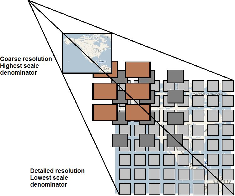
The purpose of a WMTS service is to serve maps divided into individual tiles.
FIG URE 3.2 WM TS SERVICE DIVIDED INT O TILES
3.2 Advantages of WMTS
The DigitalGlobe WMTS provides raster imagery data at multiple resolutions in predefined imagery tiles (PNG or
JPEG formats), making it more scalable and high-performing than Web Map Service (WMS). The WMTS is similar to
WMS, but it enables better server performance in applications that involve several simultaneous requests. To
improve performance, WMTS returns small pre-generated images or reuses identical previous requests that follow a
discrete set of tile matrices, rather than creating a new image for each request. This service is optimized for sending
rapid image tile delivery information from the cache for display on portals or applications where server response time
is of primary concern.
WEB MAP TILE SERVICE – DEVELOPER GUIDE
Copyright © 2013 DigitalGlobe Inc. Proprietary & ConfidentialWeb Map Tile Service Developer Guide | 13 3.3 WMTS Client-Server Architecture The following architecture depicts a sample integration of WMTS client and server applications. Client Viewer is a series of HTML pages running inside a web browser that can interact with WMTS server via client application through HTTP calls. WMTS client manages the interactions with WMTS interfaces through HTTP requests and dynamically generates HTML that can run in a Web browser. The WMTS server accepts requests from the WMTS client and the viewer client in the form of HTTP URL strings, and returns results encoded as XML, PNG, GML, and so on. FIG URE 3.3 SAM PLE WM TS CLIENT-SERVER APPLICATION 3.4 WMTS Service Details The OGC standard for WMTS defines a set of required and optional operations. The DigitalGlobe WMTS supports the following operations: GetCapabilities The GetCapabilities request is used to obtain information about the available map tile types and supported operations. GetTile The GetTile request is used to obtain an actual imagery tile. Tiles are available for a subset of the layers provided by the online catalogs. GetFeatureInfo The GetFeatureInfo request is used to obtain metadata about any tile obtained via the GetTile request. WEB MAP TILE SERVICE – DEVELOPER GUIDE Copyright © 2013 DigitalGlobe Inc. Proprietary & Confidential
Web Map Tile Service Developer Guide | 14

3.5 Basic Service Elements
This section specifies aspects of Web Map Server behavior that are independent of particular operations or are
common to several operations.

3.5.1 HTTP REQUEST
In the client-server computing model, HTTP functions as a request-response protocol. For example, in HTTP, a web
browser acts as a client, while an application running on a computer hosting a web site functions as a server. The
client submits an HTTP request message to the server. The server, which stores content or provides resources, such
as HTML files and images, returns a response message to the client. A response contains completion status
information about the request and may contain any content requested by the client in its message body.
An HTTP Uniform Resource Locator (URL) locates the Online Resource of each operation supported by a service
instance. The URL may be different for each operation, or the same, at the discretion of the service provider.
HTTP supports two request methods: GET and POST. One or both of these methods may be defined for a particular
web service and offered by a service instance. The use of the Online Resource URL differs in each case.

HTTP GET
An Online Resource URL intended for HTTP GET requests, is, in fact, only a URL prefix to which additional
parameters must be appended in order to construct a valid Operation request. A URL prefix is defined as an opaque
string including the protocol, hostname, optional port number, path, a question mark ‘?’, and, optionally, one or more
server-specific parameters ending in an ampersand ‘&’. The prefix uniquely identifies the particular service instance.
A client can append the necessary request parameters as name/value pairs in the form “name=value&”. The resulting
URL must be valid according to the HTTP Common Gateway Interface (CGI) standard, which mandates the presence
of ‘?’ before the sequence of query parameters and the ‘&’ between each parameter. Table 3.1 summarizes the
components of an operation request URL.
The URL prefix must end in either a ‘?’ (in the absence of additional server-specific parameters) or a ‘&’. In practice,
however, Clients should be prepared to add a necessary trailing ‘?’ or ‘&’ before appending the operation parameters
defined as per DG-WMS specification in order to construct a valid request URL. Please refer to Table 3.2 for reserved
characters as per HTTP rules.
TABLE 3.1 A GENERAL G ET REQUEST

                 URL COM PONENT                                              DESCRIPT ION

    http://host[:port]/path?{name[=value]&}          URL prefix of service operation. [ ] denotes 0 or 1 occurrence
                                                     of an optional part; {} denotes 0 or more occurrences. The
                                                     prefix is entirely at the discretion of the service provider.

    name=value&                                      One or more standard request parameter name/value pairs
                                                     defined by a web feature service. The actual list of required
                                                     and optional parameters is mandated for each operation is
                                                     described in the Table 4.2.

TABLE 3.2 RESERVED CHARACTERS IN HTTP GET QUERY

 CHARACTER                                    RESERVED USAGE

        ?          Separator indicating start of query string.
        &          Separator between parameters in query string.

        =          Separator between name and value of parameter
        /          Separator between MIME type and subtype in format parameter value.

WEB MAP TILE SERVICE – DEVELOPER GUIDE
Copyright © 2013 DigitalGlobe Inc. Proprietary & Confidential
Web Map Tile Service Developer Guide | 15
CHARACTER RESERVED USAGE
: Separator between Namespace and Identifier in SRS parameter value.
, Separator between individual values in list-oriented parameters.
HTTP POST
An Online Resource URL intended for HTTP POST requests is a complete and valid URL to which clients transmit
encoded requests in the body of the POST document. DGCS-WMTS do not require additional parameters to be
appended to the URL in order to construct a valid target for the Operation request. Figure 3.4 shows a sample of an
HTTP Post request.
FIG URE 3.4 SAM PLE HTTP POST REQUEST/RESPONS E
Advantages of HTTP Post instead of HTTP Get:
The Parameter’s name and value are visible to the user and to anyone who is looking at the URL in the browser.
GET requests are passed as the URL string and are therefore limited by the URL length limit specified by the
browser.
HTTP Post method can upload files to the server.
HTTPS
In addition to or instead of offering web map services using the HTTP protocol, DigitalGlobe offers web map service
using HTTPS. HTTPS is HTTP over a secure communication channel which allows encrypted information to be
transferred between machines over the World Wide Web.
The use of HTTPS does not affect the description of the requests and responses described in this document, but may
require additional actions to be taken on both the client and the service in order to initiate secure communication.
3.5.2 HTTP RESPONSE
Upon receiving a valid HTTP request, the service sends a response corresponding to the request exactly as detailed,
based on parameters for the specific operations.
Response objects will be accompanied by other HTTP entity headers as appropriate and to the extent possible. In
particular, the Expires and Last-Modified headers provide important information for caching; Content-Length may be
used by clients to know when data transmission is complete and to efficiently allocate space for results, and Content-
WEB MAP TILE SERVICE – DEVELOPER GUIDE
Copyright © 2013 DigitalGlobe Inc. Proprietary & ConfidentialWeb Map Tile Service Developer Guide | 16
Encoding or Content-Transfer-Encoding may be necessary for proper interpretation of the results. If the request is
invalid, the service issues a Service Exception.
Output Formats
The optional “outputFormat” attribute specifies the format of the response to a Cloud Service request. The default
value is text/xml; “subtype=gml/3.1.1” indicating that a valid GML3 document, that validates against a valid GML3
application schema, must be generated. For backward compatibility, the values “GML2” or “text/xml;
subtype=gml/2.1.2” may be specified indicating that a valid GML2 document that validates against a valid GML2
application schema, must be generated.Table 3.3 summarizes the possible values for the “outputFormat” attribute.
TABLE 3.3 VALUES FOR OUT PUTFORM AT ATTRIBUTE
OUT PUTFORM AT VALUE DESCRIPT ION
GML2 This value is kept for backward compatibility and indicates that an
XML instance document must be generated that validates against a
GML2 application schema.
text/xml; subtype=gml/2.1.2 Same as GML2.
text/xml; subtype=gml/3.1.1 This value indicates that an XML instance document must be
generated that validates against a GML3 application schema. This is
the default values of the outputFormat attribute if the attribute is not
specified in the GetFeature request.
3.5.3 REQUEST PARAMETERS
As per the specification standards of WMTS, a client application has to form the HTTP(S)-based URL dynamically,
based on requirement or operation it has to perform. The following are the list of important parameters which are part
of a WMTS URL.
Base URL
For every request to DigitalGlobe WMTS server, client needs to append parameters to the base URL. DigitalGlobe
provides the base URL for WMTS, which is used as the common base URL as described below.
Base URL:
https://services.digitalglobe.com/earthservice/wmtsaccess
Username and Password are required only for some accounts. All others require Connect ID.
CONNECTID
ConnectID is a parameter name which needs to be appended along with base URL mentioned above with
appropriate value. Value for these parameters is a unique 32 digit alphanumeric value. It is a mandatory parameter
which should be part of every request client makes from server. Please contact DigitalGlobe to get your unique
ConnectID.
ConnectID format: xxxxxxxx-xxxx-xxxx-xxxx-xxxxxxxxxxxx
x alpha numeric number
SERVICE
This parameter defines the type of service the client is requesting. As mentioned above, DigitalGlobe provides
different OGC services, including WMS, WFS, WMTS and WCS. Therefore, the client must an provide appropriate
value based on the service requested. The value for this parameter always is “WMTS” for WMTS clients.
Example: service=WMTS
WEB MAP TILE SERVICE – DEVELOPER GUIDE
Copyright © 2013 DigitalGlobe Inc. Proprietary & ConfidentialWeb Map Tile Service Developer Guide | 17
VERSION
The “version” parameter specifies the protocol version number. The version number indicates the specification
compliance level as defined by OGC. The format of version number contains three positive integers, separated by
decimal points, in the form “x.y.z”. The numbers “y” and “z” will never exceed 99. Each Feature Service provided by
DigitalGlobe is numbered independently as per respective OGC specification standards. The latest version of
DigitalGlobe WMTS implemented for the OGC specification is 1.0.0.
The version number appears in the following two places:
In response XML of GetCapabilities request describing WMTS service and
In the parameter list of client requests to the WMTS service.
In response to a GetCapabilities request containing a version number, a WMTS server responds with output that
conforms to that version of the specification, or negotiates a mutually agreeable version if the requested version is not
implemented on the server. If no version number is specified in the request, the server responds with the highest
version it understands and labels the response accordingly. Please refer to OGC specification for WMTS on
negotiation rules.
Example: version=1.0.0 (recommended until DigitalGlobe implements newer version per OGC specification)
REQUEST
The REQUEST parameter indicates which service operation is being invoked. The value shall be the name of one of
the operations offered by DigitalGlobe WMTS Service. Please refer to Section 3.1 for descriptions of operations
supported by DigitalGlobe WMTS.
Example: request=GetCapabilities
FORMAT
The FORMAT parameter specifies the output format of the response to a request operation. Formats are expressed
in both Capabilities XML and in operation requests using MIME types. Each Operation has a distinct list of supported
formats. Some formats may be offered by several operations, and are then duplicated as needed in each list. If a
request contains a Format not offered by WMTS server, the server throws a Service Exception (with code
“InvalidFormat”).
Example: format=image/jpeg
EXCEPTIONS
The EXCEPTIONS parameter in a request indicates the format in which the Client wants to be notified of Service
Exceptions. Individual error messages appear as elements within the
in Service Exception XML. Refer to Section 3.7 on page 21 for more details on service exceptions.
Example: exceptions=application/vnd.ogc.se_xml
3.5.4 REQUEST PARAMETER RULES
While forming request URL, client applications should follow certain rules as described below:
Parameter names are not case sensitive, but parameter values are case sensitive.
Parameter names are typically shown in uppercase for typographical clarity, not as a requirement.
Parameters in a request may be specified in any order.
When request parameters are duplicated with conflicting values, the response from the server may be undefined.
Parameters consisting of lists (for example, BBOX, LAYERS and STYLES in WMS GetMap) shall use the
comma (“,”) as the separator between items in the list. Additional white space shall not be used to delimit list
items.
Two successive commas indicate an empty item, as does a leading comma or a trailing comma. An empty list (“
“) shall be interpreted either as a list containing no items or as a list containing a single empty item, depending on
context.
WEB MAP TILE SERVICE – DEVELOPER GUIDE
Copyright © 2013 DigitalGlobe Inc. Proprietary & ConfidentialWeb Map Tile Service Developer Guide | 18
3.6 Integration Procedure
A WMTS client application is a program that communicates with the DGCS WMTS server using the operations
GetCapabilities, GetTile, and, optionally, GetFeatureInfo, as noted earlier. More specifically, in a typical WMTS client-
server interaction, the following sequence would be followed:
STEP-1
The client requests GetCapabilities from the WMTS server in order to determine what the WMTS server can do and
what features the WMTS server can provide.
Example Request:
https://services.digitalglobe.com/earthservice/wmtsaccess?SERVICE=WMTS&REQUEST=GetCapa
bilities&VERSION=1.0.0&connectid=&username=&password=
Username and Password parameters may not be applicable depending on your account type.
Replace with the ConnectID provided by DigitalGlobe. Parameters are not required to
be in the same order as shown above.
Understanding URL
The URL shown above contains Base URL and parameters, as explained in Section 3.5 on page 14. The key
parameter for this request is “request=GetCapabilities”, which fetches the capabilities of Web Map Tile Service and
responds in the form of XML data.
TABLE 3.4 UNDERST ANDING URL PAR AM ETERS FOR WMTS GET CAPABILITIES REQUEST
PARAM ETER NAM E PARAM ETER VALUE DESCRIPT ION
CONNECTID* provided by The value for this parameter is a unique 32-digit
DigitalGlobe alphanumeric value assigned by DigitalGlobe
(explained under CONNECTID in Section 3.5.3). A
valid CONNECTID is mandatory for every request.
SERVICE* WMTS Refer to SERVICE in Section 3.5.3.
REQUEST* GetCapabilities The value for this parameter should always be
“GetCapabilities” for step-1.
VERSION* 1.0.0 Refer to VERSION in Section 4.5.3.
*Mandatory
Response
In response to a GetCapabilities request, the DGCS WMTS server produces an XML document containing the WMTS
server’s service metadata, describing all the operations it supports and providing information about available map
types. The client application has to parse the XML capabilities document to retrieve the necessary information used
to request a feature. The Document Object Model (DOM) is a widely used and efficient XML parser, which can be
utilized to parse the XML document and retrieve the information. The DOM represents an XML document as a tree of
nodes that can be easily traversed and edited with its standard interfaces.
The response XML to a GetCapabilities request contains the following details:
WMTS Service details like Name, Title, URL
Contact Information Person, Organization, Address, Telephone, Fax and Email
WMTS Operations, like GetCapabilties and GetTile, with respective formats and URLs. An example of a
GetCapabilities response is shown below:
WEB MAP TILE SERVICE – DEVELOPER GUIDE
Copyright © 2013 DigitalGlobe Inc. Proprietary & ConfidentialWeb Map Tile Service Developer Guide | 19
DigitalGlobe Web Map Tile Service
OGC WMTS
1.0.0
DigitalGlobe Inc.
DigitalGlobe Customer Service
KVP
KVP
KVP
…Continued
WEB MAP TILE SERVICE – DEVELOPER GUIDE
Copyright © 2013 DigitalGlobe Inc. Proprietary & ConfidentialWeb Map Tile Service Developer Guide | 20
Continued…
_null
image/png
EPSG:3395
EPSG:4326
STEP-2
The client can request a GetTile operation from the WMTS server in order to get the actual imagery tile of a particular
tile matrix set in a predefined format. This operation has some parameters in common with WMS GetMap but it has
been deliberately simplified.
Example Request:
https://services.digitalglobe.com/earthservice/wmtsaccess?SERVICE=WMTS&VERSION=1.0.0&STY
LE=&REQUEST=GetTile&CONNECTID=&LAYER=DigitalGlobe:ImageryTileService
&FORMAT=image/jpeg&TileRow=18200&TileCol=27207&TileMatrixSet=EPSG:4326&TileMatrix=EP
SG:4326:16&featureProfile=Consumer_Profile
Replace with the ConnectID provided by DigitalGlobe. Parameters are not required to
be in the same order as shown above.
Understanding URL
The parameters required for the GetTile request are shown in Table 3.5. The client provides the following information
in a Key-Value Pair (KVP) format, where the “name” field is the key, and the “value” field is the value; the data is
supplied in the format “key=value”; for example, “service=WMTS”.
TABLE 3.5 GETTILE REQUEST PARAM ETERS
NAM E VALUE DESCRIPT ION
Service* WMTS Web Map Tile Service
Version* 1.0.0 Request version
Request* GetTile Request name
Layer* One or more of the available layers, The layers available from the Online
such as: Catalogs; if more than one layer is
DigitalGlobe:ImageryTileService requested they are in a comma-separated
list.
Available layers are advertised in the
GetCapabilities response.
Refer to Section 3.8 for more information on
various WMTS layers.
WEB MAP TILE SERVICE – DEVELOPER GUIDE
Copyright © 2013 DigitalGlobe Inc. Proprietary & ConfidentialWeb Map Tile Service Developer Guide | 21
NAM E VALUE DESCRIPT ION
tileMatrixSet* String; supported values are: The tileMatrix set to be used to generate the
EPSG:4326 response.
EPSG:3857 A complete list of supported values are
found in the GetCapabilities response.
EPSG:3395
tileMatrix* String; supported values are: The Tile Matrix identifier of the tileMatrix in
EPSG:4326:0 through the tileMatrixSet requested that has the
desired scale denominator that you want to
EPSG:4326:20 request. 4326 provides tiles where latitude
EPSG:3857:0 through and longitude are treated as X/Y values.
EPSG:3857:20 3857 provides tiles in the spherical mercator
projection.
tileRow* Integer The Row location of the tile in the defined
tileMatrixSet.
tileCol* Integer The Column location of the tile in the
defined tileMatrixSet.
Format* Mime type of the tile to be returned, The tile format to return.
for example:
image/png
image/jpeg
connectId* Character String A unique 32-digit alphanumeric value
assigned by DigitalGlobe (explained under
CONNECTID in Section 3.5.3). A valid
CONNECTID is mandatory for every
request.
The current profiles include: These profiles describe the stacking rules
Accuracy_Profile on an account. The user can choose a
profile in a request by specifying the
Aerial_CIR_Profile featureProfile. The available profiles are
Cloud_Cover_Profile advertised in the GetCapabilities response.
featureProfile Consumer_Profile
Currency_Profile
Currency_RGB_Profile
Default_Profile
True_Currency_Profile
exceptions application/vnd.ogc.se_xml Format in which exceptions will be reported;
if not specified the default is XML.
*Mandatory
Response
The response to a GetTile Request is a map tile, in the requested format and projection. All DGCS-WMTS tiles are
256x256 pixels; no other tile sizes are currently supported.
3.7 Service Exceptions
In the event that a WMTS encounters an error while processing a request or receives an unrecognized request, it will
generate an XML document indicating that an error has occurred. An element will contain one or
more processing exceptions specified using the element. Individual elements contain
exceptionCode, which specifies the actual exception that occurred.
The following is an example of an exception report. This exception indicates that a parameter value is missing and a
parameter value is invalid in the request URL.
WEB MAP TILE SERVICE – DEVELOPER GUIDE
Copyright © 2013 DigitalGlobe Inc. Proprietary & ConfidentialWeb Map Tile Service Developer Guide | 22
3.8 WMTS Layers
TABLE 3.6 WM TS LAYERS
OGC LAYER(S) DESCRIPT ION
ImageryTileService Tiled imagery for all data layers available to the account, with the
default display for a location determined by stacking profile.
CitySphereTileService Tiled imagery from the Global Basemap City Program. Stacking
profiles do not apply.
CountryCoverageTileService Tiled imagery from the Global Basemap Country Program.
Stacking profiles do not apply.
3.9 API Reference
This section provides a list of all possible request parameters for every WMTS operation and detailed information
about corresponding responses.
The client should provide the respective information in a KeyValue Pair (KVP) format for every WMS request, where
the “name” field is the key and the "value" field is the value. The data is supplied in the format “key=value”; for
example, “service=WMTS”.
GetCapabilities
The following table lists all possible request parameters for the GetCapabilities operation of the WMTS server.
TABLE 3.7 UNDERST ANDING URL PARAM ETERS FOR WMTS GETCAPABILITIES
PARAM ETER PARAM ETER VALUE DESCRIPT ION
NAM E
CONNECTID* provided by Value for this parameter is an unique 32-digit alphanumeric
Digital Globe value given by DigitalGlobe (explained under CONNECTID in
Section 3.5.3). A valid CONNECTID is mandatory for every
request.
SERVICE* WMTS Refer to “SERVICE” in Section 3.5.3.
REQUEST* GetCapabilities The value for this parameter should always be
“GetCapabilities” for step-1.
VERSION 1.0.0 Refer to “VERSION” in Section 4.5.3.
* Mandatory parameter
WEB MAP TILE SERVICE – DEVELOPER GUIDE
Copyright © 2013 DigitalGlobe Inc. Proprietary & ConfidentialWeb Map Tile Service Developer Guide | 23
4 Building a Tile Cache
4.1 Introduction
This section describes the requirements and procedure to build a tile cache into the client repository online in real-
time. Tile caching is the process by which images are downloaded and saved to a cache for faster retrieval, thus
improving performance of client applications. While navigating through AOIs, the client program can search for tiles at
respective locations on the local disk without requesting DGCS-WMTS every time. If the tiles are not available on the
local disk for the specified region, the request can be sent to DGCS-WMTS GetTile request and the tiles can be
saved accordingly.
4.2 Building a Tile Cache from DigitalGlobe WMTS
A client program can communicate with the DGCS WMTS server using the GetTile request for a set of valid Tile
Rows and Tile Columns at a given zoom level to build the Tile Cache. The client program has to request
GetCapabilities from the WMTS server in order to determine what the WMTS server can do and what features the
WMTS server can provide. More specifically, in a typical WMTS Tile-Cache client/server interaction, the following
steps can be followed:
4.2.1 STEP 1: BUILD TILE CACHE
Identify the Tile Row, Tile Column range for the required AOI and request for GetTile at different zoom levels and
required file formats to receive map tile response. Refer to Introduction to WMTS on page 12 for more details.
4.2.2 STEP 2: GETTILE REQUEST
An example request for a tile is:
Name: Imagery
Sample URL:
https://services.digitalglobe.com/mapservice/wmtsaccess?SERVICE=WMTS&VERSION=1.0.0&REQ
UEST=GetTile&LAYER=DigitalGlobe:ImageryTileService&FORMAT=image/jpeg&STYLE=&CONNE
CTID=&TileMatrixSet=EPSG:3857&TileMatrix=EPSG:3857:
&TileRow=&TileCol=
Replace with the ConnectID provided by DigitalGlobe. Replace ,
, and with the required values. Parameters are not required to
be in the same order as shown above.
The above given URL contains Base URL, and parameters as explained in Basic Service Elements on page 14. The
key parameter for this request is “request=GetTile” which fetches the tiles of WMTS and responds in the form of an
image.
The Parameters required for the GetTile request are shown in Table 3.5.
4.2.3 STEP 3: CACHING GETTILE RESPONSE
The response to a Tile Cache Request is a map tile, in the requested format and projection. All DGCS-WMTS tiles
are 256x256 pixels; no other tile sizes are currently supported.
In the following GetTile output response image, you may note the values of Tile Rows and Tile Columns at zoom
level 16.
WEB MAP TILE SERVICE – DEVELOPER GUIDE
Copyright © 2013 DigitalGlobe Inc. Proprietary & ConfidentialWeb Map Tile Service Developer Guide | 24
TileRow=31503
TileCol=47304
TileRow=31504 TileRow=31504 TileRow=31504 TileRow=31504
TileCol=47303 TileCol=47304 TileCol=47305 TileCol=47306
TileRow=31505 Response image
TileCol=47304 Zoom level=16
FIG URE 4.1 TILE CACHE RESPONSE IM AGE
On successful building, the tile bytes are received from a series of requests, which can be read through respective file
operations API of any programming language and can be saved to local disk/required location. A suggested folder
structure to save map tiles locally is given below.
Example:
Assumptions
Tile Cache QA/Error processing must be detected and raised by the user.
A certain number of threads (simultaneous requests) are allowed to access the system, which is reportable, is
provided to the user.
The customer may choose from metadata in two formats (tab-delimited or XML).
The tiles X,Y,Z necessary to cover landmass AOI down to zoom 18, should be known by the user.
It is recommended only going to zoom level 12 for portions of the AOI that are all ocean.
User should know how to transform the filenames into any caching strategy.
User would build their ESRI World-file, as needed.
4.3 Updating Tile Cache
To determine the process by which you should update the tile cache, contact your DigitalGlobe representative.
4.4 World-File Generation
If needed by the application, you must generate your own world-file for each tile. The following link describes the
contents of a world file: http://en.wikipedia.org/wiki/World_file.
The z, x, and y values are used to translate from indexes to valid Lat/Lon values. The Lat/Lon values are used for
lines 5 and 6 of the world-file.
WEB MAP TILE SERVICE – DEVELOPER GUIDE
Copyright © 2013 DigitalGlobe Inc. Proprietary & ConfidentialWeb Map Tile Service Developer Guide | 25
Glossary
AOI
Area of Interest. The area on the Earth that you want to view.
Bilinear Interpolation
Bilinear interpolation uses the value of the four nearest cell centers to determine the value on the output raster.
The new value is a weighted average of these four values, adjusted to account for their distance from the center
of the output cell. The result is a smoother-looking surface than provided by “nearest neighbor”.
Bicubic Interpolation
Bicubic interpolation combines data points on a two-dimensional grid. This method outputs the smoothest
surface of all interpolation methods.
GeoTIFF format
A GeoTIFF file is a TIFF file that is embedded with geographic data tags.
GML
Geography Markup Language. GML is XML code used to express geographical features.
Nearest Neighbor Interpolation
Uses the value of the closest point and disregards all other values, yielding a piecewise-constant interpolant.
OGC
Open GIS Consortium. An international standards organization comprised of commercial, governmental,
nonprofit and research organizations. They support geospatial content development as well as data processing
and sharing.
OWS
OGC Web Service Common.
Partition
The unit of measure based on the tile zoom level grid for tar file creation for imagery tiles. All tiles and associated
metadata for a partition will be tar-compressed into a single file.
UTM
Universal Transverse Mercator Geographic Coordinate System. UTM utilizes a two-dimensional Cartesian
system to specify locations on the Earth’s surface.
WCS
Web Coverage Service.
WFS
Web Feature Service.
WMS
Web Map Service.
WMTS
Web Map Tile Service.
WEB MAP TILE SERVICE – DEVELOPER GUIDE
Copyright © 2013 DigitalGlobe Inc. Proprietary & ConfidentialWeb Map Tile Service Developer Guide | 26
Index
AbstractFeature, 7 request/response, 15
AbstractFeatureType, 7 HTTP request, 14
API reference, 22 HTTPS, 15
area of interest, defined, 25 integration procedure, 18
Base URL, 16 nearest neighbor, defined, 25
bicubic interpolation, defined, 25 network link
bilinear interpolation, defined, 25 example URL, 23
building a tile cache, 23 OGC
CONNECTID, 16 defined, 25
dictionary schema more information about, 5
document location, 8 OutputFormat attribute values, 16
overview, 8 OWS, defined, 25
EXCEPTIONS, 17 partition, defined, 25
folder structure, 24 REQUEST, 17
FORMAT, 17 request parameter rules, 17
generating a world file, 24 SERVICE, 16
Geography Markup Language. See GML service exceptions, 21
GeoTIFF, defined, 25 suggested folder structure, 24
GET query reserved characters, 14 supported tile sizes, 23
GET request URL, 14 tile cache
GetCapabilities building, 23
description, 13 updating, 24
request, 18 tile request example, 23
response, 18 tile sizes, supported, 23
GetTile tile, overview, 5
description, 13 VERSION, 17
request assumptions, 24 WCS, defined, 25
request parameters, 20 web map tile service. See WMTS
response, 21 WFS, defined, 25
response, caching, 23 WMS, defined, 25
GML WMTS
defined, 25 advantages, 12
overview, 6 client-server architecture, 13
GML schema layers, 22
features, 7 overview, 5, 12
overview, 6 sample client-server application, 12
HTTP GET, 14 service details, 13
HTTP POST WMTS, defined, 25
advantages, 15 world file generation, 24
overview, 15
WEB MAP TILE SERVICE – DEVELOPER GUIDE
Copyright © 2013 DigitalGlobe Inc. Proprietary & ConfidentialYou can also read