Implementation of Complete Systematic Land Registration in Order to Modernize Indonesian Land Administration System
←
→
Page content transcription
If your browser does not render page correctly, please read the page content below
Implementation of Complete Systematic Land Registration in Order to
              Modernize Indonesian Land Administration System

                                     Hendry Yuli WIBOWO, Indonesia

            Key words: PTSL, Fit-For-Purpose Land Administration, Geospatial Data

   SUMMARY
   Indonesian land registration officially started on 1960 at the time when the basic agrarian law
   was born. As per 2016, there are estimated 126 million land parcels available in Indonesia.
   From 1960 until 2016, only 41.8 million parcels have been registered. From this number, as
   the first issue, annually less than one million parcels can be registered. On this speed,
   Indonesia needs another 85 years to completely record all unregistered land parcels. Another
   issue is data quality. From 41.8 million parcels, estimated only 20 million parcels have been
   verified and has been correctly plotted onto the map.
   To overcome those issues, the government of Indonesia is now on the way to utilize fit-for-
   purpose land administration approach to modernize its land administration system. Fit-for-
   purpose land administration concept is arranged by three key principles comprise of spatial
   framework, legal framework and institutional framework. This approach has been put into
   practice in several countries such as Rwanda and Nepal as participative land registration. FFP
   concept is known as optimal and quick approach to build a new paradigm of land
   administration system. The implementation of this approach in Indonesia was initialized on
   2017. The initiative is a part of national priority program and called Complete Systematic
   Land Administration (Pendaftaran Tanah Sistematis Lengkap/PTSL).
   Based on official reports, on 2017 the program successfully registers 4.9 million parcels and
   map more than 5.4 million. On 2018, it is projected that PTSL will generate 7.5 million
   registrations. The number will be increased year by year with the ultimate objective is to
   completely map and register all land parcels before 2025. This paper is a note of the ongoing
   progress of PTSL throughout 2017 to 2018 and the recent strategies to improve the quality of
   geospatial data and the implementation for multipurpose cadaster.

Implementation of Complete Systematic Land Registration in Order to Modernize Indonesian Land Administration
System (9931)
Hendry Yuli Wibowo (Indonesia)
FIG Working Week 2019
Geospatial information for a smarter life and environmental resilience
Hanoi, Vietnam, April 22–26, 2019
RINGKASAN Pendaftaran tanah Indonesia secara resmi dimulai pada tahun 1960 pada saat tindakan dasar hukum agraria lahir. Per 2016, diperkirakan 126 juta bidang tanah tersedia di Indonesia. Dari tahun 1960 hingga 2016, hanya 41,8 juta paket telah terdaftar. Dari nomor ini, sebagai edisi pertama, setiap tahunnya kurang dari satu juta parsel dapat didaftarkan. Pada kecepatan ini, Indonesia membutuhkan 85 tahun lagi untuk sepenuhnya merekam semua bidang tanah yang tidak terdaftar. Masalah lainnya adalah kualitas data. Dari 41,8 juta parsel, diperkirakan hanya 20 juta parsel yang telah diverifikasi dan telah diplot dengan benar ke peta. Untuk mengatasi masalah-masalah tersebut, pemerintah Indonesia sekarang sedang dalam perjalanan untuk menggunakan pendekatan administrasi pertanahan yang sesuai dengan tujuan untuk memodernisasi sistem administrasi pertanahannya. Konsep administrasi pertanahan yang sesuai untuk tujuan diatur oleh tiga prinsip utama yang terdiri dari kerangka spasial, kerangka hukum dan kerangka kelembagaan. Pendekatan ini telah dipraktikkan di beberapa negara seperti Rwanda dan Nepal sebagai pendaftaran tanah partisipatif. Konsep FFP dikenal sebagai pendekatan yang optimal dan cepat untuk membangun paradigma baru sistem administrasi pertanahan. Implementasi pendekatan ini di Indonesia dimulai pada 2017. Inisiatif ini merupakan bagian dari program prioritas nasional dan disebut Pendaftaran Tanah Sistematis Lengkap (PTSL). Berdasarkan laporan resmi, pada 2017 program ini berhasil mendaftarkan 4,9 juta paket dan memetakan lebih dari 5,4 juta. Pada 2018, diproyeksikan bahwa PTSL akan menghasilkan 7,5 juta pendaftaran. Jumlah ini akan meningkat dari tahun ke tahun dengan tujuan akhir adalah untuk memetakan dan mendaftarkan semua bidang tanah sepenuhnya sebelum tahun 2025. Makalah ini adalah catatan dari kemajuan PTSL yang sedang berlangsung sepanjang 2017 hingga 2018 dan strategi terkini untuk meningkatkan kualitas data geospasial untuk keperluan multipurpose cadaster. Implementation of Complete Systematic Land Registration in Order to Modernize Indonesian Land Administration System (9931) Hendry Yuli Wibowo (Indonesia) FIG Working Week 2019 Geospatial information for a smarter life and environmental resilience Hanoi, Vietnam, April 22–26, 2019
Implementation of Complete Systematic Land Registration in Order to
Modernize Indonesian Land Administration System
Hendry Yuli WIBOWO, Indonesia
1. INTRODUCTION: LAND ADMINISTRATION IN INDONESIA
1.1 Basic Agrarian Law
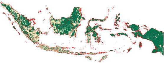
The total land area of Indonesia is 1.9 million km2. 66% of it is reserved as forestry zone and
only 34% or 650.000 km2 can be utilized as non-forest zone for development purposes.
Although control of land for welfare purposes of people has been stated on the 1945
constitution article 33, the beginning of Indonesian land administration was commenced by
the implementation of Basic Agrarian Law on 1960. This act facilitates transfer of right from
old Dutch colonial title into Indonesian recognized title (Winoto, 2009). Land administration
in Indonesia fragmented into two main parts: (1) for forestry zones, there are forestry law that
enable Ministry of Environment and Forestry to strongly and independently control and
utilize designated forest area, (2) Meanwhile one third of non-forest land is regulated and
managed on Basic Agrarian Law 1960. By having dualism on land control imply that no title
can be established on the forest area (Bakker & Moniaga, 2010).
Table 1. Land rights Established under the Basic Agrarian Law (Behuria, 1994)
Hak Atas Tanah (Land Rights)
Hak Milik Right of ownership
Hak Guna Bangunan Right building
Hak Pakai Right of use
Hak Pengelolaan Right of management
Hak Guna Usaha Right of exploration
Furthermore, land and forests have an important meaning for communities’ custom law. The
existence of customary law communities in Indonesia is an integral part of their lives. The
relation between occupants (adat people) with occupied land has a religio-magical
relationship. This relationship causes the fellowship to acquire the right to control the land, to
collect the harvests of plants on the land, and to hunt animals there. Article 3 of Law Number
5 of 1960 on the Basic Agrarian Law contains the provision that relational rights to this land
are called ulayat rights. In accordance with Article 5 of Basic Agrarian Law 1960, customary
law remains in effect as long as it does not contravene national and national interests, national
unity, and socialism of Indonesia. The issue of ownership of indigenous land or customary
forest is one of the main causes of forest conflict in Indonesia. Conflicts of recognition of
rights holders of customary land are having negative impacts to indigenous peoples. Frequent
conflict is around the uncertainty of the status of indigenous peoples' rights in the forest area
and the uncertainty of the forest area boundaries. Conflicts of ownership of indigenous rights
are often in a weak position. Most of the conflict cases in the custom forest area have not been
Implementation of Complete Systematic Land Registration in Order to Modernize Indonesian Land Administration
System (9931)
Hendry Yuli Wibowo (Indonesia)
FIG Working Week 2019
Geospatial information for a smarter life and environmental resilience
Hanoi, Vietnam, April 22–26, 2019successfully completed yet. Other issue is including bank-financed projects across sectors that delayed because difficulties on land acquisition as (Behuria, 1994). 1.2 Government Regulation number 10 1961 regarding Land Registration Government Regulation number 10 1961 is the implementation of Basic Agrarian Law 1960 for land registration. Basically, this regulation stated that land registration need to be done village to village. In reality, land registration based on Government Regulation Number 10 of 1961 for more than 3 decades is not enough to provide satisfactory results. Calculation on 1997 stated that from approximately 55 million eligible land parcels, only 16.3 million fields have been registered. Meanwhile, the rapid development in Indonesia increase the number of land parcel time to time. The limitation of this regulation including the shortages of national budget, minimum capacity of measurement tools and labor, and large numbers of parcels are spread over a large area, cannot be done simultaneously. Furthermore, it is impossible to implement registration in a short time with satisfying results. Related with that, the new regulation for land registration is published as Government Regulation number 24 1997. This regulation was defining more comprehensive methods, purposes and supporting aspects for land registration. Adjudication process, aerial photograph and sporadic approach were used in this era that last for 20 years. But still, the large growth of number of parcels is not as quick as the registration process. Until the end of 2016, estimated number of parcels of land in Indonesia is approximately 126 million parcels, and only one third or 44 million parcels that have been registered. 1.3 Regulation concerning Complete Systematic Land Registration Regulation for PTSL was issued on 2016 as Regulation of Minister of Agrarian and Spatial Planning/Head of National Land Agency Number 35 2016 that revised into Regulation of Minister of Agrarian and Spatial Planning/Head of National Land Agency Number 12 2017 and then Regulation of Minister of Agrarian and Spatial Planning/Head of National Land Agency Number 6 2018. Significant differences between these new approaches to the previous are that the systematic and complete approach will benefit on (1) completely map all the existing parcels start in the village unit. Including identifying parcels that has been registered but not yet plotted correctly on the map, (2) Minimizing the potential of overlap between parcels, and (3) Identify parcels in dispute. The initial target of PTSL 2017 was registering 5 million land parcels. The initiative was taken at the end of fiscal year of 2016. Having all resources has not been ready to perform significant increase of target compare to previous year, the following chapter shows the steps needed to address resources issues. 2. THE NEED FOR ACCELERATION Before 2017, less than 2 million parcels registered annually. And by this rate, it takes decades before complete map of Indonesia can be achieved. Therefore, in accordance with the President's Program realized in NAWACITA to present the state to protect all nations and provide security for all citizens through Agrarian Reform and Land Registration in all Indonesian Territories, the acceleration of land registration is set up on 2017. The acceleration is implemented in program of Pendaftaran Tanah sistematis Lengkap (PTSL) or Complete Systematic Land Registration. Implementation of Complete Systematic Land Registration in Order to Modernize Indonesian Land Administration System (9931) Hendry Yuli Wibowo (Indonesia) FIG Working Week 2019 Geospatial information for a smarter life and environmental resilience Hanoi, Vietnam, April 22–26, 2019
Figure 1. Land of Indonesia: Green for forestry zone, and yellow for non-forestry zone
   This acceleration is not only aim to records all land parcels, but also to address land disputes
   through Indonesia (between land owners, between local communities (adat people)), initiate
   parcel-based decision making, and also to improve the data and information quality of land
   parcels (including overcome the issues of overlap between land ownership). PTSL is also in
   line with the Global Agenda of Sustainable Development Goals (SDGs) universal set of 17
   goals and 169 targets that set for 15 years (2016 – 2030). The goals are action oriented, global
   in nature and universally applicable. The SDGs include six goals with a significant land
   component.
   The basic idea of Complete Systematic Land Registration that has been initiated since 2017 is
   to identify and to obtain records of all land parcels in Indonesia. A systematic and complete
   mindset occupies the leading position for final planning, implementation and evaluation. The
   figure below shows the very basic idea on how 4 categories of PTSL implemented in the field.
   The boxes show complete systematic land registration in the village unit:
   -    K1 – is for the parcels that meet all requirements: parcel boundary is clear. The adjacent
        owners agreed on the boundary. The owner of the parcel can also show their ID and other
        required legal documents;
   -    K2 – is for parcels that status is in dispute, i.e., adjoining parcel owners is not agree with
        the boundary or, there are inheritance disputes between families, or the parcels is still
        contested in the court.
   -    K3 – is a parcel that boundary can be identified clearly in the field, but the owner is not
        available to shows required legal documents.
        K1, K2, and K3 are for parcels that has never been measured or registered before.
        Meanwhile K4 is defined as follows:
   -    K4 - In a village, there are some parcels that have been registered. There are two types of
        registered parcels. First is the validated parcels that has been correctly plotted on the map,
        and other type is parcels that has been registered but the correct plots is unknown, or not
        correctly plotted on the map. For this case, we call it category K4. Field surveying based
        on data from certificate will fix the exact location of the plot on the field.
Implementation of Complete Systematic Land Registration in Order to Modernize Indonesian Land Administration
System (9931)
Hendry Yuli Wibowo (Indonesia)
FIG Working Week 2019
Geospatial information for a smarter life and environmental resilience
Hanoi, Vietnam, April 22–26, 2019
Valid
registered
parcels
Unregistered
parcels
K1 K2 K3
K4
Data and Survey and
Information mapping Registration process’
Improvement categories
Figure 2. Concept of complete systematic land registration
By implementing PTSL, there will be additional number of registered and mapped parcels
through K1 and K3 as well as enhancing data and information of parcels through K4 and also
resolve disputes and conflict through K2. Based on the regulation, the step of implementation
is: (1) preparation, (2) social publication, (3) field data collection, (4) data processing, (5)
adjudication, (6) announcement and (7) certification of land parcel.
Fit-for-purpose land administration practice in Regency of Grobogan is where ideal complete
systematic land recording was performed. The program of participatory mapping based on fit
for purpose approach has been implemented since 2014. By using large scale satellite
imagery, the villagers voluntarily show their indicative parcel boundary on the map. They also
provide ID card as proof of ownership of the parcel. This method also will enable people to
self-check of land parcels adjacencies to other parcels (Fahmi, 2016). The program
incorporate associated institution in regency level to organize synchronized activity to record
all land record for mutual benefits. Regency government support the budgeting, local land
office provide information on registered and unregistered parcels and also support quality
control on data acquisition, village community actively contribute valid information regarding
their own occupied and owned land and third party incorporated to perform digital mapping
activity. By 2018, all parcels in 281 villages in Grobogan regency have been successfully
recorded.
Implementation of Complete Systematic Land Registration in Order to Modernize Indonesian Land Administration
System (9931)
Hendry Yuli Wibowo (Indonesia)
FIG Working Week 2019
Geospatial information for a smarter life and environmental resilience
Hanoi, Vietnam, April 22–26, 2019Figure 3. Participatory land parcel mapping in Grobogan Regency 2.1 ‘Man’ Component At the end of 2016, the number of in-house land surveyor was only 1.952 people throughout Indonesia. By Estimating that one person can only achieve 1.000 parcels per year, roughly only 2 million parcels can be measured. It is obvious that the number of in-house land surveyor is not sufficient to achieve the target. Meanwhile, recruiting new land surveyor is not possible since it require huge and long term dedication of national budget. Because of that, engaging licensed cadaster surveyor is the only option. At that time, there was no direct control on around 2.723 licensed surveyors that has been licensed since 2013. So the fastest response on preparing human resource as cadaster surveyor was to establish new regulation, providing new working procedure, re register all of licensed surveyor and control them by system. The new regulation provided was Regulation of Minister of Agrarian and Spatial Planning/Head of National Land Agency Number 33 2016 that enhanced by Regulation Number 11 2017 regarding Licensed Cadaster Surveyor. This new regulation that replace similar regulation number 9 2013 regarding Licensed Surveyor, enable the ministry to recruit licensed cadaster surveyor from source other than STPN (Sekolah Tinggi Pertanahan Nasional or National Land Institute). So far, the recruitment of licensed surveyor from STPN only contribute annually around 350 to 400 both licensed surveyor and land surveyor, while PTSL need at least additional 3.000 licensed cadaster surveyor. To address this issue, ATRBPN then coordinating with several ministries and institutions to recruit new licensed surveyor from other sources. The first ministry that will be able to supply licensed surveyor is Ministry of Education and Cultural which coordinating Vocational High School. The graduate of this high school student especially from Geomatics and Surveying courses are eligible for having licensed cadaster surveyor after taking an exam. Furthermore, Ministry of Research, Technology and High Education agree to supply annually around 250 graduate of Geodetic Engineer as licensed cadaster surveyor. The ministry of ATR/BPN also allocates a chance for ATR/BPN retiree to have a licensed as long as they are less than 70 years old and willing to contribute more to the ministry. Another attempt was to have an MOU with Ministry of Labor that coordinating regional work training center that has been established on each province. By working together with other ministries, on 2017 and 2018 licensed surveyor recruited are 3008 and 3.886 respectively as shown in the figure below. Implementation of Complete Systematic Land Registration in Order to Modernize Indonesian Land Administration System (9931) Hendry Yuli Wibowo (Indonesia) FIG Working Week 2019 Geospatial information for a smarter life and environmental resilience Hanoi, Vietnam, April 22–26, 2019
12000

                                            10000

                                             8000

                                             6000

                                             4000

                                             2000

                                                0
                                                      2014          2015     2016       2017       2018
                       Assistant of Cad. Surv         1679          2039     2427       4492       7690
                       Cadaster Surveyor               114           151      296       1239       1927

                       Figure 4. The growth of licensed cadaster surveyor 2014 – 2018

   By the end of December 2018, there are total 9.617 licensed cadaster surveyor consist of
   1.927 cadaster surveyor and 7.690 cadaster Surveyor's assistant. This figure is significantly
   increased from only 2000 on 2016. Meanwhile the number of in-house land surveyor is not
   significantly increased on 2.505 persons. All of these surveyors are already engaged on the
   program throughout 2017 and 2018. The figure below shows the process of recruiting new
   licensed cadaster surveyor.
                        INPUT                                    PROCEDURE                         OUTPUT
                                                                    RE
              Non surveying High school
                   student graduate

                                                    Vocational Education
               Survey-related vocational
                                                        and Training
                 high school graduate                   (2-6 Months)
                                                           And/or            Exam for
                                                        Internship in         License
               Graduate student related             Provincial /local Land   Cadaster          Licensed Cadaster
                   with surveying                           office           Surveyor              Surveyor

                 10 years experiences
               assistant of land surveyor

              Pensioner of ATR/BPN 20
              yrs experience in surveying

                      Figure 5. Recruitment procedure for Licensed Cadaster Surveyor

Implementation of Complete Systematic Land Registration in Order to Modernize Indonesian Land Administration
System (9931)
Hendry Yuli Wibowo (Indonesia)
FIG Working Week 2019
Geospatial information for a smarter life and environmental resilience
Hanoi, Vietnam, April 22–26, 2019
Other implication from regulation regarding licensed cadaster surveyor is the establishment of
new Private Company of Licensed Surveyor (Kantor Jasa Surveyor Kadastral Berlisensi or
KJSKB). By the end of 2018, there are 132 KJSKB established on 23 provinces in Indonesia.
2.2 ‘Material’ Component
Materials needed for PTSL are base map and measurement tools. The working map will
enable surveyors to have better orientation of the field they are measuring. ATRBPN mostly
use high resolution satellite imagery as working map. Ortho-rectified satellite imagery
coverage in Indonesia at the end of 2016 was 45% of non-forest area. Mostly Java, Bali and
Nusa Tenggara islands are having full coverage, while the other island such Sumatera,
Kalimantan, Maluku and Papua doesn’t have enough coverage due to limited national budget.
Base Map that becomes basic resource for parcel identification is a map that informs all or
part of natural and artificial elements that are on the surface of the earth with a certain scale
and follows certain mapping rules. This map is used as a reference in making other maps.
Other maps used as base map is Base Registration Map which is a map that is used as a
reference for making land registration maps, this map contains Technical Base Points and all
or some geographic elements such as rivers, roads, buildings, physical boundaries of land,
elevation lines and administrative boundaries.
Furthermore, based on Regulation of Minister of Agrarian and Spatial Planning/Head of
National Land Agency Number 6 2018, base maps for PTSL is a map that used in the context
of land registration, spatial planning and preparation of other land thematic maps, which can
be obtained from: terrestrial mapping, photogrammetric mapping (aerial photographs) or from
High Resolution Satellite Imagery (CSRT) and Unmanned Aerial Vehicle (UAV).
To provide more coverage of high resolution satellite imagery, ATR/BPN is now working
together with LAPAN (Lembaga Antariksa Nasional/National Space Agency) and BIG
(Badan Informasi Geospasial/Geospatial Information Agency). LAPAN is the only institution
that have authority to acquire satellite imagery, while BIG is the institution where raw satellite
imagery data is ortho-rectified.
2.3 Multipurpose Cadaster
According to Enemark 2009, the modern land administration system must be able to be a part
of its utilization for (1) Land Tenure aspects, namely security and ownership of land rights
represented in Property, HGU, HGB and others, (2) Land Value, namely for the purposes of
land and taxation assessments (such as the United Nations), (3) Land use relating to space
policy and planning and land use control and (4) land development, namely regulations and
implementation for licensing and planning development (Enemark, 2009).
For multipurpose cadaster, comprehensive and standardized geospatial data and information
of parcels is important thing to be prepared. The practice of comprehensive geospatial data
can be seen in the Spatial Data Infrastructure policy which has been initiated in Europe,
Australia and America. In principle, SDI allows the discovery and transmission of spatial data
from data storage, through spatial service providers to users.
- Europe INSPIRE is an initiative to bring together European Union geospatial data in a
spatial data infrastructure with the aim of making decisions on activities that have
Implementation of Complete Systematic Land Registration in Order to Modernize Indonesian Land Administration
System (9931)
Hendry Yuli Wibowo (Indonesia)
FIG Working Week 2019
Geospatial information for a smarter life and environmental resilience
Hanoi, Vietnam, April 22–26, 2019environmental impacts (Inspire, 2019). INSPIRE's spatial data infrastructure will enable
sharing of data and information between public sector organizations for across boundary
policy making. This initiative began in 2007 and will gradually function fully in 2021.
Operated by members throughout the European Union INSPIRE displays 34 themes of
spatial data needed. The matters regulated in this synergy include metadata, data
specifications, network service, data and service sharing and monitoring and reporting.
From the documentation, it can be seen that INSPIRE adopted ISO related geographic
information such as ISO 19101 Geographic Information - Reference model, ISO 19115
Geographic Information – Metadata;
- Netherland National Georegister is a spatial data geoportal in the Netherlands that
provides maps related to cadastral and planning, environment, civil buildings, utilities,
transportation and agriculture. Built based on the GeoNetwork 3.0 API software, this
National Georegister is one of the nodes in INSPIRE that provides metadata services,
view and download geographic data and information from the National Georegister center
catalog (NGC, 2019). Data users are Geo-IT specialists for web and application
development and related agencies that are looking for datasets, services and other
geospatial data and information. To ensure interoperability, standards used for metadata,
catalogs, and data sharing protocols at the National Georegister are in accordance with
INSPIRE standards;
- The German National Data Infrastructure was originally developed by German survey
authorities. Data from this institution is a comprehensive SDI backbone that covers all
data segments of the friction (Muller, 2006). This infrastructure was later developed into
GDI-DE (Geospatial Data Infrastructure for Germany) which consisted of NGDB
(National Geodatabase - reference data, thematic data and metadata) and Geoportal.Bund
(Central entrance to GDI-DE) (Grunreich, 2009). GDI-DE becomes part of INSPIRE
(UNGGIM, 2016);
- The US National Spatial Data Infrastructure is represented at the Federal Geographic Data
Committee (FGDC), which is an organization consisting of professionals and constituents
who provide executive, managerial direction related to geospatial data between states for
policy making (FGDC, 2019). FGDC is currently developing the National Spatial Data
Infrastructure including: (1) the development of geospatial shared services through
geospatial platforms, Cloud computing, and interoperability.
3. PROGRESS THROUGH 2017 AND 2018
As shown on the figure 6, on 2017, PTSL target was to register 5 million parcels. The final
product was 5.4 million parcel map (comprise of 4.35 million registration certificate (K1) and
43 K2 parcels, and 0.53 million K3 Parcels and 0.51 million K4 Parcels). Meanwhile on 2018,
the target was 7.5 million parcels and the final product was 9.3 million parcel map (6 million
registration certificate, 1,966 K2 parcels, 2 million K3 and 1.1 million K4).
Compare to land registration in pre-PTSL era, the realization on 2017 has been attained more
than 500% and more than 800% on 2018. The acceleration by mean of quantity has already
been obtained successfully by improving cooperation and synergy with related institutions
and by optimizing internal capacity.
Implementation of Complete Systematic Land Registration in Order to Modernize Indonesian Land Administration
System (9931)
Hendry Yuli Wibowo (Indonesia)
FIG Working Week 2019
Geospatial information for a smarter life and environmental resilience
Hanoi, Vietnam, April 22–26, 20199.344.352
2017 2018
6.029.155
5.402.950
4.354.674
2.160.282
1.152.949
534.723
513.510
1.966
43
K1 K2 K3 K4 TOTAL
Figure 6. Complete systematic land registration progress of 2017 and 2018
4. ROOM FOR IMPROVEMENT
Furthermore, the national program of Complete Systematic Land Registration (PTSL) in 2019
is the third year of implementation with the target of 8.25 Million Land Parcel Map. Referring
to the successful implementation in previous years, the target is likely to be realized. With a
projected success of 100%, the number of PBTs at the end of 2019 if added with the results of
2017 (5.4 million PBT) and 2018 (9.3 million PBT) at the end of 2019 there will be nearly 23
million plots of land acquired.
The 23 million land parcels - which were obtained in just three years - represent a significant
achievement compared to the availability of land parcels in 2016, which were only 46 million
land plots result from 56 years land registration process. With the same consistency (9 to 10
million PBT per year), the next five years (2020-2025) - according to the mandate of the ATR
Minister / Head of BPN - all land parcels in Indonesia will be successfully mapped and
recorded.
Thus, the number of plots of land to be mapped and managed by the ATR / BPN will be very
large and complex. Because of the massive amount of data and information on land parcels
mapped and then registered, it is necessary to handle comprehensive geospatial data and
information.
Learning from 2017 and 2018, Ministry of ATRBPN is now starting to define its own vision
that will become foundation of development through 2045. The vision of ATR/BPN is
including (1) human resources and technology improvement, (2) sustainable economic
development, (3) equivalent development, (4) national sustainability and institutional
arrangement including transforming the organization into digital era.
Implementation of Complete Systematic Land Registration in Order to Modernize Indonesian Land Administration
System (9931)
Hendry Yuli Wibowo (Indonesia)
FIG Working Week 2019
Geospatial information for a smarter life and environmental resilience
Hanoi, Vietnam, April 22–26, 2019Figure 7. Geospatial data and information quality improvement
In order to improve data quality of complete systematic land registration, the things that can
be done includes:
- The institutional transformation of the ATR / BPN Ministry towards the era of digital
culture is supported by integrated and reliable backbone data and geospatial information;
- The availability of applications with the latest technology with high standards, data
sharing capabilities and data collaboration with relevant agencies will be easier to do,
business processes become more efficient, quality and reduce financing;
- Availability of content, services and applications for geospatial data and information that
can be accessed anytime, anywhere on the web or mobile platforms;
- This initiative will also be part of the process of forming spatially enable government
where one of the spatial plans will be land-based, allowing the application of the 3R
concept (Rights, Responsibilities and Restrictions).
- From the figure 7 above, the mechanism of geospatial data and information quality
improvement is start by auditing all available geospatial data on local office units. By
verifying its spatial validity on the field
5. FINAL REMARKS
The improvement of PTSL implementation in the context of spatial data quality in this paper
tends to touch many technical aspects, especially in the provision of geospatial data and
information that is user friendly and through various media. Therefore, the changes will on
the legal aspects and budgeting aspects also be needed. Especially to adopt with the
institutional transformation that likely to occur.
Furthermore, any form of modern land administration will still reflect people's relations to
their activities on land, the Ministry of ATR/BPN as an institution entrusted with managing it
Implementation of Complete Systematic Land Registration in Order to Modernize Indonesian Land Administration
System (9931)
Hendry Yuli Wibowo (Indonesia)
FIG Working Week 2019
Geospatial information for a smarter life and environmental resilience
Hanoi, Vietnam, April 22–26, 2019is the only institution that best understands this social concept as well as its relationship with
land ownership, taxes of land, control of land use, land development and spatial management.
Therefore, even though it is adopted from international best practice on land administration,
PTSL is established as a national distinctive approach that best implemented for Indonesian
character. Thus, the support for changes and enhancements of mid-term agenda including
prepare the authentic Indonesian land administration and developing geospatial data
infrastructure relies entirely on the political will of the minister of ATR Head of the National
Land Agency and his staffs.
REFERENCES
Bakker, L., & Moniaga, S. (2010). The Space Between: Land Claims and the Law in
Indonesia. Asian Journal of Social Science 38, 187-203.
Behuria, S. (1994). Some Aspects of Land Administration in Indonesia: Implication for Bank
Operations. Jakarta: Asian Development Bank.
Enemark, S. (2009). Global Trends in Land Administration. Beirut: FIRST
INTERNATIONAL CONFERENCE OF THE ARAB UNION OF SURVEYORS.
Fahmi, M. (2016). Peningkatan Kualitas dan Kuantitas Database Pertanahan Melalui
Kegiatan Pemetaan Partisipatif di Kabupaten Grobogan. Grobogan: Kantah Kab.
Grobogan.
FGDC. (2019, 01 23). Federal Geographic Data Committee. Retrieved from fgdc.gov:
https://www.fgdc.gov/index_html#
Inspire. (2019, 01 23). Inspire. Retrieved 01 23, 2019, from Infrastructure for Spatial
Information in Europe: https://inspire.ec.europa.eu/
NGC. (2019, 01 23). the location of geo information from all over the Netherlands. Retrieved
from nationaalgeoregister.nl:
http://nationaalgeoregister.nl/geonetwork/srv/dut/catalog.search#/home
Sahide, M., & Giessen, L. (2015). The fragmented land use administration in Indonesia –
Analysing bureaucratic responsibilities influencing tropical rainforest transformation
systems. Land Use Policy, 96-110.
UNGGIM. (2016). Germany - National Spatial Data Infrastructures. Retrieved from
ggim.un.org: http://ggim.un.org/knowledgebase/KnowledgebaseArticle50412.aspx
Winoto, J. (2009). TAKING LAND POLICY AND ADMINISTRATION IN INDONESIA
TO THE NEXT STAGE AND NATIONAL LAND AGENCY’S STRATEGIC
PLAN. Workshop In International Federation of Surveyors' Forum. Washington DC.
BIOGRAPHICAL NOTES
Hendry Yuli Wibowo (1983) is an expert of cadaster data analysis of Directorate Thematic
Survey and Mapping. His interests involve land administration and management, GNSS data
acquisition and technology, participatory mapping and spatial database analysis. He got his
degree from Geodetic Engineering of Gadjah Mada University, Indonesia and master degree
from Spatial Information Science University of Melbourne, Australia.
Implementation of Complete Systematic Land Registration in Order to Modernize Indonesian Land Administration
System (9931)
Hendry Yuli Wibowo (Indonesia)
FIG Working Week 2019
Geospatial information for a smarter life and environmental resilience
Hanoi, Vietnam, April 22–26, 2019CONTACTS
Mr. Hendry Yuli Wibowo
Directorate General of Agrarian Infrastructure
Ministry of Agrarian and Spatial Planning
Jalan Kuningan Barat I no. 1 Mampang Prapatan, Jakarta Selatan
DKI Jakarta
INDONESIA
Tel. +62 81 584 583 860
Email: wibowo.hendry@gmail.com
Web site: http://hendriwibowo.wordpress.com
Implementation of Complete Systematic Land Registration in Order to Modernize Indonesian Land Administration
System (9931)
Hendry Yuli Wibowo (Indonesia)
FIG Working Week 2019
Geospatial information for a smarter life and environmental resilience
Hanoi, Vietnam, April 22–26, 2019You can also read