Addendum to the Southeast Coastal Ocean Observing Regional Association (SECOORA) Build Out Plan
←
→
Page content transcription
If your browser does not render page correctly, please read the page content below
Addendum to the Southeast Coastal Ocean Observing
  Regional Association (SECOORA) Build Out Plan

      Originally submitted to NOAA IOOS: September 30, 2011
                   Revision: October 30, 2017

                                                              1
SECOORA Build Out Plan, 5 Year Review (2017-2021)
This document is an addendum to the SECOORA 10 Year Build Out Plan (2011-2021),
originally submitted to NOAA IOOS September 30, 2011. The 10 Year Build Out Plan (BOP)
serves as the SECOORA RCOOS Plan. The BOP focuses on prioritizing observations,
information products, and models that meet user needs within the following SECOORA thematic
areas: Marine Operations; Climate Variability and Change; Ecosystems, Fish, and Water
Quality; and, Coastal Hazards. Note that after the 10 Year BOP was submitted, SECOORA
revised the focus area names to: Marine Operations; Coastal Hazards; Climate Variability; and,
Ecosystems: Water Quality and Living Marine Resources. The observing system
recommendations within this addendum remain consistent with these thematic areas.
The original SECOORA BOP, while thorough, included limitations and assumptions which
SECOORA has now has been able to address or further analyze. For example, since 2011
SECOORA has been able to: increase stakeholder engagement and learn more about local and
regional observing and modeling needs; leverage resources with partners to install new sensors
and observing stations; and, develop models specific to stakeholder needs. This addendum to
the BOP provides recommendations for incorporating new coastal and ocean observations
based on member and stakeholder input. The original BOP did not specifically list locations for
deployment of new observing assets. This addendum includes priority asset locations specific to
High Frequency Radar (HFR), coastal and oceanographic moorings, and glider deployments.
This addendum incorporates recommendations from national plans (e.g. High Frequency Radar
Plan, Glider Plan), SECOORA documents, and stakeholder feedback. At this point, priority
locations for estuarine monitoring have not been fully vetted; however, this task will be
undertaken prior to the next RCOOS Plan revision.
The tables at the end of the original BOP (Table 1: Marine Operations, Table 2: Climate
Variability, Table 3: Ecosystems, Table 4: Coastal Hazards) remain valuable as the data,
products and services, and models identified within each thematic table remain relevant to
SECOORA members and stakeholders.
1.0 Background:
SECOORA is part of the US Integrated Ocean Observing System (IOOS®), which evolved out
of earlier sub-regional programs. SECOORA and its Regional Coastal Ocean Observing System
(RCOOS) were supported from 2011-2016 by grant award NA11NOS0120033 administered
through the NOAA US IOOS Program Office. The present SECOORA award,
NA16NOS0120028, also funded by the NOAA US IOOS Program Office, covers the period
2016-2021.
SECOORA integrates observations, models, data management and outreach in developing and
sustaining an end-to-end RCOOS that is responsive to societal needs. Our information
management system transforms data and analyses into value-added products and services
consistent with priorities identified through regularly updated stakeholder needs assessments.
SECOORA also recognizes that meeting stakeholder needs requires a sound scientific
approach. We therefore place emphasis on coordinating a multidisciplinary suite of coastal
ocean observations with suitably chosen simulation models so that societally important
phenomena may be described, understood and ultimately predicted via applications of best
science practices. During the period 2011-2016 and continuing into the current funding period,
2SECOORA is sustaining a suite of observations consisting of: HFR for surface currents and
waves; moored buoys for surface meteorology and water column velocity, temperature, salinity
and in some instances waves; coastal stations for surface meteorology and water level; glider
surveys, including bio-optics measurements, along with temperature and salinity; and,
supported limited exploratory measurements regarding bio-acoustics. These observational
components are coordinated with models across multiple scales and applications. Real-time
data provided to the public, directly or through National Data Buoy Center (NDBC) distribution,
supports safe and more pleasurable coastal ocean outings and numerical weather prediction by
the NWS. In addition, SECOORA-related modeling is used to explain phenomenon such as
harmful algal blooms (HABs), storm surge, fisheries recruitment, beach water quality, and
identify oil spill trajectories. SECOORA funding supports an array of coastal ocean
observations in addition to benefitting society across a spectrum of coastal ocean applications.
The priorities over 2016-2021 period are to sustain critical observing and modeling activities.
We will also seek new leveraging opportunities and to add new multidisciplinary elements as
may be possible under the existing funding constraints, all while continuing to refine activities to
improve upon their effectiveness in meeting user needs. Specifically, SECOORA seeks to:
• Effectively engage users and other stakeholders to prioritize investments
• Provide data management and communication (DMAC) infrastructure
• Sustain the HFR network distributed from Cape Hatteras to west Florida, and continue
coordinating with the national network
• Sustain in situ stations offshore of North Carolina, South Carolina, and Florida
• Sustain modeling efforts
• Begin to address observing gaps
• Continue delivery of automated model Nowcast/Forecast products and products based
on data collected through the HRF network, in situ observations, and gliders
2.0 Components of observing systems
A regional observing system is a comprehensive operation that includes all the components
necessary to collect observations and turn them into useful and meaningful information
products. The SECOORA observing system consists of the following core components that are
integrated into a unified system as summarized below (adapted from the Synthesis of Regional
IOOS Build-out Plans for the Next Decade).
Observing platforms and sensors (covered in sections 3 and 4 of this document):
• Platforms fixed in place that collect and relay data from above and/or below the water
and provide detailed information on particular locations. These include shore stations on
piers as well as offshore moorings that collect data on an array of meteorological and
oceanographic variables.
• Mobile platforms that transit broad swaths of the ocean, conducting monitoring along
transect lines or responding to specific events such as upwelling or spills. These
platforms, such as autonomous gliders and powered underwater vehicles, or more
traditional ships, complement the point measurements collected by fixed platforms.
• Remote instruments and platforms, such as high frequency radars and satellites, that
provide synoptic views of surface conditions.
3Models (covered in section 5 of this document):
• Systems of mathematical equations solved on computers, used to infer information for
places, times, and/or parameters that cannot be measured, and to forecast how the
environment will change over time
• Observing systems use models to simulate a variety of atmospheric and ocean
properties, including temperature, salinity, currents, waves, and water quality.
• Regional-scale models are nested within basin and global-scale models to provide users
with higher resolution forecasts.
Data management:
• Data management and integration that support seamless access to regional data
• Ensures that data is archived, recorded, and transmitted in ways that are consistent in
content and format with other providers of the same data
• Ensures that data products are available 24/7 to meet user/stakeholder need
• The SECOORA data management and communication (DMAC) plan was revised in
2017 as part of the NOAA IOOS Certification process. This DMAC plan is incorporated
by reference into this BOP addendum.
Product development and engagement with users:
• Engagement with decision-makers and users to fully understand specific needs for IOOS
information, the most appropriate formats and channels to receive the information, and
to share knowledge to develop effective products
• Analysis that translates data into useful and meaningful information products
• Product development that integrates multiple types of measured and modeled data into
higher level products
System management:
• System management to oversee operations, identify priorities, and ensure routine and
reliable delivery of information.
3.0 Existing Observing Platforms and Sensors
In light of reduced funding for award NA11NOS0120033 (2011-2015) and award
NA16NOS0120028 (2016-2021), SECOORA has conducted a review of the original 10 Year
Build Out Plan (2011-2021) so that this revised BOP addendum is consistent with the
SECOORA Strategic Plan, the current NOAA IOOS Cooperative Agreement
(NA16NOS0120028), and meets the identified ocean observing, modeling, and DMAC needs of
SECOORA partners and stakeholders. The original Build Out Plan (BOP), while thorough,
included limitations and assumptions which SECOORA has now has been able to address or
further analyze; therefore, this addendum to the BOP provides a 5-year review that is a
scientifically sound and justifiable strategy for incorporating new coastal and ocean
observations, as funding becomes available.
SECOORA’s highest priority is to continue supporting coastal ocean observing assets that
provide current and long-term data necessary to meet stakeholder needs. The existing
4SECOORA assets enable SECOORA to address themes of Marine Operations; Coastal
Hazards; Climate Variability; and, Ecosystems: Water Quality and Living Marine Resources (for
more details on the stakeholder needs by thematic area, see SECOORA 10 Year BOP,
Products tables for each thematic area). For the 2016-2021 SECOORA IOOS funded effort, our
highest priorities include maintaining the existing SECOORA assets which include 15 region
wide HFRs and 22 in situ stations in coastal and offshore North Carolina, South Carolina, and
Florida.
3.1 High Frequency Radar
HFR installations have evolved through a combination of research funding and state agency
investment. SECOORA will continue to support both CODAR and WERA HFR within the region.
The station list for SECOORA maintained High Frequency Radar (HFR) installations is provided
in Table 1. Since 2011, when the original BOP was written, SECOORA members have installed
one new CODAR system off of Cape Hatteras, NC and one new WERA system off of Caswell
Beach, NC. These stations are included on Table 1.
• University of South Carolina (PI Voulgaris): A WERA station was purchased and
deployed at Caswell Beach, NC (CSW) through an NSF research award. This station is
paired with the Georgetown, SC (GTN) HFR to provide overlapping coverage for Long
Bay, SC. SECOORA, through its NOAA IOOS award, provides funding to support
operations and maintenance for this site.
• UNC Coastal Studies Institute, Ocean Energy Program: Two historic CODAR sites,
DUCK and HATY, are located on the NC Outer Banks. A third CODAR station was
purchased and deployed at Core Banks, NC in 2014, expanding coverage along the NC
Outer Banks. In May 2015, the IOOS office provided additional funding to enable long
term maintenance of the site, filling one of several regional coverage gaps. SECOORA,
through its NOAA IOOS award, provides funding to support operations and maintenance
for this site.
Table 1. SECOORA HFR assets identified by station name, location, HFR type, and
organization responsible for station operation.
Station Lead
Location HFR Type POC
Name Organization
HATY Cape Hatteras, NC CODAR UNC Chapel Hill Harvey Seim
DUCK Duck, NC CODAR UNC Chapel Hill Harvey Seim
CORE Core Banks, NC CODAR UNC Chapel Hill Harvey Seim
Univ. of South
CSW Caswell Beach, NC WERA George Voulgaris
Carolina
Univ. of South
GTN Georgetown, SC WERA George Voulgaris
Carolina
Skidaway Institute
CAT St. Catherine’s GA WERA Dana Savidge
of Oceanography
Skidaway Institute
JEK Jekyll Island, GA WERA Dana Savidge
of Oceanography
STF Dania Beach, FL WERA Univ. of Miami Nick Shay
5Station Lead
Location HFR Type POC
Name Organization
VIR Virginia Key, FL WERA Univ. of Miami Nick Shay
CDN Crandon, FL WERA Univ. of Miami Nick Shay
Reddington Univ. of South
RDSR CODAR Robert Weisberg
Shores, FL Florida
Univ. of South
FDS Ft. DeSoto, FL WERA Robert Weisberg
Florida
Univ. of South
VEN Venice, FL WERA Robert Weisberg
Florida
Univ. of South
VENI Venice, FL CODAR Robert Weisberg
Florida
Univ. of South
NAPL Naples, FL CODAR Robert Weisberg
Florida
3.2 Fixed Platforms
There are two main components for fixed platforms, coastal stations and moored offshore
buoys. The station list for SECOORA maintained fixed platforms (e.g. coastal stations and
moorings) is provided in Table 2. Since 2011, when the original BOP was written, SECOORA
has been unable to maintain all of the moorings within its domain. For example, the following
stations have been removed from service:
• University of South Florida (Weisberg) removed station C14 from service during 2012.
• Florida Institute of Oceanography proposed to fund the eight SEAKEYS stations that
were deployed along the Florida Keys to monitor coral reefs. Due to reduced funding the
SEAKEYS network was discontinued in 2012.
• University of South Florida (Luther) did not have the resources to rebuild the Egmont
Key and Ana Maria Island sites after tropical storms Debby and Isaac in 2012. The Anna
Maria site was officially decommissioned in April 2013 and Egmont Key was
decommissioned in July 2013.
• University of North Carolina Wilmington (Leonard) removed the OCP1 pier station from
service in 2014. This station was located on Oak Island, Brunswick County, NC.
There have been partnering success stories that have allowed SECOORA and regional partners
to add new stations and enhance existing stations. These efforts include:
• In 2012 UNCW was notified by NDBC that the annual maintenance costs for the
LEJ3/412036 mooring would increase from $40,000 to $60,000. It was determined that
the contract with NDBC would not be renewed. A fundraising campaign was established
by SECOORA. UNCW personnel worked with the boating and fishing communities in NC
and secured $17,000 in donations from individuals and foundations. These funds were
used to deploy a new mooring with meteorological sensors and a CTD at the original
LEJ3 position. USACE then provided a WaveRider buoy to co-locate with the new
mooring so that spectral wave data could be provided for the USACE Wave Information
Study (WIS) and to NOAA NDBC and NWS.
• SECOORA worked in partnership with the North Inlet Winyah Bay National Estuarine
Research Reserve (NERR), part of the Baruch Institute, University of South Carolina to
establish a piling-based water quality station in Winyah Bay, SC to support NERRS
6water quality monitoring efforts. This station began collecting data in May 2016. Long
term maintenance of the station will be provided by the NERR.
• Mote Marine Laboratory (Locascio), in 2016, worked with USF personnel (Luther), to
incorporate passive acoustic sensors and acoustic telemetry on the Big Carlos Pass
station in Lee County, FL. These sensors are used to measure fish sound production
and behavior as an indicator of ecosystem function.
• SECOORA, UNCW, FACT, Ga DNR, and the Smithsonian Environmental Research
Center worked together to deploy acoustic receivers on moorings in Onslow Bay, NC
and northern Long Bay, NC to aid with fish tracking as part of the Animal Telemetry
Network.
• SC Department of Natural resources, in coordination with USACE, USCG, SC Port
Authority, SC DHEC, and SECOORA installed a piling-based water quality station in
Charleston Harbor. Funding from 2016-2021 SECOORA IOOS funded effort award was
used to leverage support from other state and federal agencies.
Table 2 provides a list of the 22 SECOORA fixed platforms and data collected at each site.
Fish
Wind Spd, Air Barometric Rel. SW/LW Water Cond/ Water Water
Currents Waves Acoustic
Gust, Dir. Temp Pressure Humidity Radiation Temp Salinity Quality Level
Sensors
UNCW Moorings
LEJ3 - Outer Onslow Bay X X X X X X X
LEJ3Wave X X
ILM3 - Outer Onslow Bay X X X X X X X
ILM2 - Inshore Onslow Bay X X X X X X X
ILM2Wave X X
SUN2 - Northern Long Bay X X X X X X X
SUN2Wave X X X
CAP2 - Inshore Capers Island X X X X X X
FRP2 - Inshore Fripp Island X X X X X X
SC DNR Mooring
Charleston Harbor Station* X X X
UGA OA Moorings
OA sensor suite** on 41008 X X X X X X
USF Moorings
C10 - WFS Central nearshore X X X X X X X X
C12 - WFS Central offshore X X X X X X X
C13 - WFS South X X X X X X X
C11 - WFS Subsurface*** X X X
C15 - WFS Subsurface*** X X X
C21 - Tower X X X X X X X X
USF Coastal Stations
Shell Point X X X X X X
Aripeka X X X X X X
Fred Howard State Park X X X X X
Clam Bayou X X X X X X X
Big Carlos Pass X X X X X X X X
*Water Quality measurements include dissolved oxygen, pH, turbidity, chlorophyll, FDOM, and water depth
**This sensor suite is co-located with NDBC mooring 41008 in Grays Reef NMS. NDBC maintains buoy and UGA maintains OA and water quality sensors.
Sensors deployed specific to OA and water quality include: pCO2, pH, dissolved oxygen, turbidity, chlorophyll, water temp., and salinity
***Non real-time station, waves are non-directional
3.3 Gliders
Mobile assets, in general, collect high spatial density data, augmenting the moored array. Most
are easy to deploy and all are flexible in terms of mission objectives and event response, the
7only such observing resource with these capabilities. Data collected with these assets support
weather forecasts, search and rescue, event response, ecosystem and climate modeling
programs. Glider observations characterize the subsurface distributions of temperature, salinity,
chlorophyll-a, particles and other properties, and are used to improve, validate, and constrain
regional circulation and ecosystem ocean models. Modeling products constrained by
assimilation of three-dimensional temperature and salinity fields provide powerful tools for
stakeholders involved in management efforts.
SECOORA has invested funds from the 2016-2021 SECOORA IOOS funded effort in the use of
gliders to help determine shelf circulation and water properties in the South Atlantic Bight (SAB).
The SAB is affected by a variety of processes and characteristics that are unique to the region
(i.e., broad and shallow shelf, influence of strong boundary currents, strong tidal forcing,
distributed river input, passage of powerful tropical storms and hurricanes). These processes
have wide ranges of spatial and temporal scales not easily observed with traditional technology,
which has led to a historic lack of information on density stratification i and horizontal and vertical
structure of biologically relevant variables.
Glider data provides regional 4-D information about temperature, salinity and density structure,
and oxygen, turbidity, CDOM, and chlorophyll concentrations. These measurements are used to
1) investigate hydrography and circulation dynamics, bottom temperatures and cross-shelf
pathways between the shelf edge and nearshore; 2) use control theory and ocean models to
develop intelligent control capabilities ii allowing gliders to recognize and correct for fronts and
strong currents; 3) prepare glider data for integration into circulation and ecosystem modeling
efforts; 4) efficiently deliver information to the modeling community and stakeholders (e.g.,
bottom temperature maps to NOAA fishery science centers) through SECOORA DMAC and the
IOOS glider data assembly center (DAC); and 5) use this base of regional glider operations for
leveraged efforts supported by GRNMS, National Science Foundation, NASA, and state
agencies.
Glider missions are a multi-institutional endeavor, with gliders being flown along the east coast,
from FL to NC. Gliders being used are owned by Skidaway Institute of Oceanography (SkIO),
University of South Florida (USF), UNC Chapel Hill, and NC State University (NCSU). These
gliders are being deployed from locations in Florida and Georgia on shelf- and shelf-edge
sampling missions with northward trajectories. Shelf surveys are conducted by deploying two
gliders, one off Cape Canaveral and the other off of coastal Georgia, with operations
approximately between the 20m and 50m isobaths. Shelf edge surveys are conducted by
deploying a glider off Cape Canaveral that rides Gulf Stream currents along the entire SAB
before recovery off North Carolina. Other SkIO glider missions focus on Gray’s Reef National
Marine Sanctuary. Multiple gliders are being deployed from the Duke University Marine Lab and
the UNC Coastal Studies Institute near Cape Hatteras as part of a NSF-funded project.
Glider operations integrate and take advantage of in situ and HFR observations, satellite
imagery, and regional model predictions to optimize glider tracks. All gliders deployed will
incorporate Vemco Mobile Transceivers (VMT), acoustic monitoring receivers to track tagged
fishiii and at least one will be outfitted with an integrated VMT to transmit detections in real time.
Acoustic data will be shared with the fisheries research community (Ocean Tracking Network,
FL Atlantic Coast Telemetry, iTAG, GRNMS). Collaborative work between oceanographers and
engineers at University of Georgia, SkIO, Georgia Tech, and NCSU will explore new methods of
8acoustic telemetry facilitated by autonomous platforms operated using intelligent control
strategies.
4.0 Expansion of the Observing Platforms and Sensor Network:
The original 10 Year BOP includes a general identification of all the assets required within the
SECOORA domain that would enable SECOORA to fully address the SECOORA thematic
areas. The 10 Year BOP, while comprehensive and stakeholder vetted, does not prioritize
observing network assets. This addendum to the BOP takes into account priorities identified in
the SECOORA 2016-2021 proposal (grant NA16NOS0120028) and the SECOORA strategic
plan, previous user needs assessments, the 2014 SECOORA User Assessment Survey, and
member and stakeholder input gathered during the 2017 SECOORA Annual Members and
Stakeholder meeting. This document reflects a prioritized list of observing platforms and
sensors that will enable SECOORA to continue to meet ongoing modeling, product
development, and stakeholder data requirements. It should be noted that this is not as
exhaustive list but it does help SECOORA identify key areas where observations are required.
4.1 High Frequency Radar
In 2014, Shay et al. completed the High Frequency Radar Observing Systems: SECOORA Gap
Analysis, which outlined a plan for expanding the HFR network across the SECOORA domain.
Recommendations from this document were included in the National Surface Current Plan
(NOAA IOOS, 2015) which provides an overview of High Frequency Radar (HFR) needs within
the U.S. and also identifies gaps within each RA. Based on information found within these
documents, 39 HFRs are needed to provide full coverage for the SECOORA domain. Currently
there are 15 existing SECOORA stations; however, Florida Atlantic University (FAU) has
installed and is operating two stations near Miami, FL. These stations do not receive IOOS or
SECOORA funding but they do help fill gaps within the HFR network. Therefore, 22 stations are
needed within the SECOORA domain fill existing coverage gaps.
The top three locations for new HFR deployments, as identified in the 2011-2015 SECOORA
IOOS proposal (NA11NOS0120033) and associated progress reports are as follows:
1. Install and operate 2 new HFRs east of Port Canaveral, FL: To address critical gaps in
the current HFR network, Florida Institute of Technology (FIT) and the University of
Miami (UM) should deploy two 8-channel, 8 MHz WERA systems; one at FIT’s Vero
Beach Marine Lab and one at the Air Force Station next to Kennedy Space Center (a
distance of ~45 nm or 83 km). These systems will fill critical gaps in HFR coverage along
the east coast of FL.
2. UM is working with partners in the Florida Keys to identify a location in the lower Keys
region for a WERA installation that will provide radar coverage across the Florida Straits
and be able to measure the Florida Loop Current/Gulf Stream.
3. USF has prioritized installation of a CODAR at Ft. DeSoto Park. This station would be
coincident with the WERA that is already there and will provide a radial overlap
perspective and it requires no additional permitting and no new power or
communications.
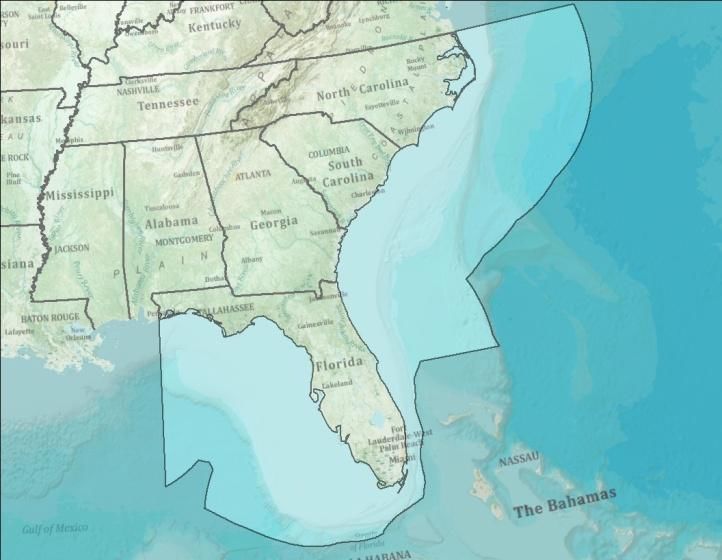
9Map 1 identifies existing HFR locations as well as the proposed priority locations. This map
highlights how the three proposed HFR locations will help fill gaps in HFR coverage within the
region.
Map 1. High
Frequency Radar
within SECOORA
domain. Green dots
denote planned HFR
deployment
locations. Orange
dots represent
SECOORA funded
HFR. The blue dots
are non-SECOORA
funded HFR
operating in the
region.
4.2 Fixed Platforms
There are two main components, coastal stations and moored offshore buoys. Coastal stations
directly address the need to document variability in the nearshore and inshore environments.
Many coastal systems exist (e.g. NOAA CO-OPS water level stations, National Estuarine
Research Reserve System (NERRS) stations, Everglades National Park water quality stations,
and Indian River Lagoon water quality monitoring network) and provide valuable estuarine and
nearshore data. Few offshore buoys exist, and a significant number of them measure only
surface properties. A consistent array of buoys that provide surface and subsurface (i.e.
atmospheric, physical oceanographic, and biogeochemical) data are needed throughout the
SECOORA domain.
SECOORA members and stakeholders have identified locations for moored offshore buoys and
the addition of new sensor suites (e.g. ocean acidification, acoustic) to existing stations, which
10are needed to address significant regional issues related to fisheries management, water
quality, climate variability, coastal and marine hazards, and environmental threats such as OA.
By adding new capabilities, SECOORA will be strategically poised to meet the needs of a
variety of regional and national user-groups, bridging the gap between our observing efforts and
the end user.
The SECOORA domain was broken into three subregions and in situ observing priorities have
been identified by subregion in the nearshore and offshore environments. The subregions
include: NC, SC, and GA; east coast of FL; and west coast/Gulf of Mexico. When considering
prioritization of asset placement or enhancements to existing assets, the following criteria were
considered: ecological features within the subregion, circulation impacts on ecology, boundary
conditions (e.g. Gulf Stream), inner shelf and outer shelf differences, wave conditions, proximity
of shipping lanes (so as to not site assets within); and, stakeholder identified needs. The priority
stations identified across the SECOORA domain will provide valuable data for SECOORA
products, such as the Marine Weather Portal, and modeling efforts such as How’s the Beach?
and the SABGOM ocean circulation model.
The NC, SC, and GA region includes real-time moorings established by the UNCW Coastal
Ocean Research and Monitoring Program (CORMP), NOAA NDBC, NOAA CO-OPS water level
stations, SCRIPPS/USACE CDIP moorings, University of Georgia (OA monitoring), and project
related moorings such as those established by UNC-Chapel Hill for the NSF funded PEACH
project. The priorities for this region range from low cost options, such as adding additional
sensors to existing moorings, to higher cost options of deploying new real-time or non-real-time
moorings in key locations (e.g. nearshore within river plumes and seafloor instruments under
the Gulf Stream). The priorities for the fixed platforms in the coastal and ocean region offshore
of NC, SC, and GA are as follows:
• Equip existing SECOORA moorings operated by UNCW with full sensor suites (Table 2,
specifically ILM2, ILM3, LEJ3, SUN2, CAP2, FRP2). Additional sensors to add to these
moorings include pH and PCO2 (for OA research), chlorophyll, CTDs throughout the
water column, and water column currents.
• Add mid-shelf (20-50 m) and outer-shelf (60 m) moorings in Long Bay, SC offshore of
the Myrtle Beach region and within the Caswell/Georgetown HFR coverage area.
• Extend Long Bay mooring line with 2-3 CPIES deployed on the seafloor, under the Gulf
Stream. These stations will also be within the Caswell/Georgetown HFR coverage area.
Information on CPIES is available: http://www.po.gso.uri.edu/dynamics/IES/index.html.
• Equip NDBC stations 41013 (Frying Pan Shoals) and 41010 (Canaveral East) with OA
sensor suites.
• Install water quality sensors at inshore locations at major river entrances, specifically,
the Savannah River, GA and the Cape Fear River, NC. These could be piling stations or
SECOORA could work with the US Coast Guard to instrument aids to navigation within
the river entrances. These stations should be instrumented, at a minimum, to match the
Charleston Harbor station, deployed in 2017.
o Stations should measure water quality parameters: water temperature, salinity,
dissolved oxygen, pH, turbidity, chlorophyll fluorescence and fluorescence of
dissolved organic matter (FDOM, a proxy for total dissolved organic carbon).
11The east coast of Florida is the most data sparse area within the SECOORA region. There are
six NOAA CO-OPS stations along the east coast which provide shore based water level and
meteorological data collection to support storm surge monitoring. The SCRIPPS/USACE CDIP
program has deployed 4 Waverider buoys off the east coast of Florida, which has helped fill
some data gaps (note that at the time of this addendum, one CDIP mooring, 227, Oculina Banks
North Florida, is in the process of being moved to a new location). Additionally, SECOORA and
its partners successfully lobbied NOAA to maintain the Cape Canaveral NDBC mooring (41009)
which provides vital information to NASA, SpaceX, and Port Canaveral. The CDIP and NDBC
moorings provide valuable data for marine safety and transportation sectors and coastal
process modeling; however, since the CDIP moorings only provide spectral wave and surface
water temperature data, they do not provide the meteorological and additional in-water data
required by many SECOORA user groups (e.g. fisheries, marine safety).
Coastal and Offshore moorings deployed off the east coast of Florida, within the 10 – 50 meter
isobaths, are required to fill data gaps for marine safety and transportation, to better understand
ecosystems, fisheries, and water quality (productivity and capture upwelling events), and
address public health concerns and coastal hazards (HAB tracking and rip current forecasting).
Moorings with a full suite of instrumentation (meteorological, surface and sub-surface physical
and biogeochemical) are needed in the following locations off the east coast of Florida (ranked
by importance) as few, if any, stations exist in these areas:
• Miami
• Sebastian Inlet
• Jacksonville
• Fort St. Lucie
• Fort Pierce
• Delray Beach
The west coast Florida region has coastal stations and ocean moorings already established by
the USF Coastal Ocean Monitoring and Prediction System (COMPS), NOAA NDBC, NOAA
PORTS (part of NOS), NOAA CO-OPS water level stations, SCRIPPS/USACE CDIP moorings,
Tyndall Air Force Base Towers, and NERRS stations. While there are seemingly a large number
of stations on the Gulf Coast of Florida, most are shore-based stations supporting water level
and meteorological data collection. The offshore moorings, operated and maintained by
COMPS, NDBC, CDIP, and the Air Force, provide valuable data for marine safety and
transportation sectors and coastal process modeling; however, more stations are required in the
following priority locations to support fisheries management, water quality, climate variability,
coastal and marine hazards, and environmental threats such as OA. The following locations off
the west coast of Florida (ranked by importance) were identified as the priority locations for
mooring deployments:
• Southwest corner of west Florida shelf, northwest of the Pulaski Shoals Light (PLSF1).
Needs meteorological data, in-water currents, waves, salinity, and temperature.
• Pensacola Bay, specifically the Middle Grounds which is a major fisheries area within
the Gulf of Mexico. A mooring that includes a full suite of biological, oceanographic, and
meteorological parameters is needed.
• Shallow southwest FL shelf at 10 m isobaths, north of Key West, FL. Needs
meteorological data, water temperature, salinity, chlorophyll, nutrients, OA sensor,
12acoustics to support fisheries, wave heights, currents. This location drives ecological
conditions in Florida Keys National Marine Sanctuary, Everglades National Park, and the
Florida Keys.
• DeSoto Canyon, shelf break, south of Destin, FL. This is an important upwelling area
and meteorological data as well as in water data such as waves, currents, temperature,
and salinity are needed.
• Northeast of mooring 42036, West Tampa NDBC buoy. This location, south of
Tallahassee, requires surface meteorological data.
• East of 42036, West Tampa NDBC buoy at the 20 m isobath. Identified needs for this
location include meteorological data, waves, water temperature and salinity.
• Florida Bay on the 20 m isobath, east of the COMPS C13 mooring. This location needs
meteorological data, waves, and water temperature.
• Upgrade the Conch Reef/Aquarius Reef Base Station (operated by Florida International
University) to include meteorological, water temperature, salinity, chlorphyll, nutrients,
OA sensors, acoustics to support fisheries, wave heights, currents.
The overwhelming need for nearshore and offshore moorings highlights stakeholder desire for
traditional observing stations that contain a suite of instruments that can cater to more than one
stakeholder need. As funding levels have remained consistent, SECOORA has been able to
maintain many of the stations that are currently deployed. New stations have required
SECOORA and is members to leverage funds with other state and federal agencies, and even
employ a crowdsource funding campaign, to fill data gaps. The long list of priority moorings and
sensor additions to existing moorings identified by SECOORA stakeholders and members, will
not be achievable through SECOORA efforts alone. Therefore, it is essential for SECOORA to
work with stakeholders and members to identify additional funding mechanisms to fill gaps
within the region.
The simplest way to narrow down the top 3 gaps within the SECOORA domain is to identify the
top sub-regional needs (e.g. Carolinas and Georgia, East Coast of Florida, and West Coast of
Florida) and move those needs forward. By taking the top 3 approach, the following new
moorings should be deployed as funding allows:
1. East Coast of Florida: Add a mooring offshore of Miami. At a minimum, the moorings
should collect meteorological data, water temperature and salinity, waves, and currents.
If funding allows, add sensors for OA monitoring (pH, pCO2) and fisheries monitoring
(acoustic receivers).
2. Carolinas and Georgia: Add mid-shelf (20-50 m) and outer-shelf (60 m) moorings in
Long Bay, SC offshore of the Myrtle Beach region and within the Caswell/Georgetown
HFR coverage area. At a minimum, the moorings should collect meteorological data,
water temperature and salinity, waves, and currents. If funding allows, add sensors for
OA monitoring (pH, pCO2) and fisheries monitoring (acoustic receivers).
3. West Coast of FL: Add a mooring on the southwest corner of west Florida shelf,
northwest of the Pulaski Shoals Light (PLSF1). At a minimum, the moorings should
collect meteorological data, water temperature and salinity, waves, and currents. If
funding allows, add sensors for OA monitoring (pH, pCO2) and fisheries monitoring
(acoustic receivers).
13While this Top 3 approach does make sense, this method lacks flexibility. A better approach is
for SECOORA and its stakeholders to coordinate filling gaps in mooring locations based on the
ability to leverage support from stakeholders and to apply for other (i.e. non-IOOS) funding
opportunities. For example, if SECOORA or one of its partners applies for funding to expand OA
monitoring, then OA sensors could be added to existing moorings throughout the region (which
is an example of a priority from the most recent SECOORA IOOS proposal NA16NOS0120028
(2016-2021)). Therefore, SECOORA will maintain the full list of sub-regional coastal and ocean
mooring needs documented in this section (4.2), and submit this list for inclusion in the
Implementation Plan for the National Strategy for a Sustained Network of Coastal Moorings.
The current and proposed moorings are located in Map 2.
Map 2. Orange dots
represent SECOORA
funded coastal and
offshore buoys. Green
dots are CDIP WaveRider
buoys deployed in the
SECOORA region. Blue
dots are non-SECOORA
funded buoys (e.g.
NOAA NDBC). Purple
dots represent potential
mooring locations
identified and prioritized
at the 2017 SECOORA
annual meeting by
members and
stakeholders. The
purple line off the coast
of SC indicates the
potential location for 2-3
non real-time sub-
surface C-PIES which will
help track the Gulf
Stream.
4.3 Gliders
The 2014 IOOS white paper, Toward a U.S. IOOS Underwater Glider Network Plan: Part of a
comprehensive subsurface observing system, notes that expansion of the glider observatory will
allow for more robust subsurface ecosystem and physical oceanographic observations and
enhance modeling efforts around the nation. Gliders are able to carry a suite of physical and
biogeochemical sensors that provide fine resolution observations of the coastal ocean. Glider
14data is useful for emergency response (i.e. oil spill response), HAB detection, climate variability
analysis, and hurricane intensity forecasting.
The current SECOORA glider operations are listed in section 3.3 of this document. Gliders are
currently being deployed along east coast of the SECOORA domain, from North Carolina south
to Cape Canaveral, FL, specifically to collect data within the South Atlantic Bight. Glider
observations gaps have been identified from Cape Canaveral south and around and into the
Gulf of Mexico. SECOORA should work with the Gulf of Mexico Coastal Ocean Observing
System (GCOOS) to coordinate glider deployments in the Gulf of Mexico as both RAs have
overlapping boundaries and GCOOS has identified priority glider tracks along the west coast of
Florida in its Build Out Plan. This will allow for more robust data collection and sharing as well
as collaborative modeling opportunities. Additionally, SECOORA gliders are close to 10-years
old and investment in new gliders, to replace aging systems, should be prioritized.
5.0 Modeling
SECOORA is implementing a robust strategy to acquire atmospheric and oceanographic
observations from HFR, coastal and oceanographic moorings, and gliders. These observations
are being linked to predictive models and decision-making tools essential to improving
forecasting of severe weather events and marine conditions. SECOORA supports a numerical
modeling framework (sub-regional to regional scale models) to provide validated modeling
products for managers and other users. It is assumed that national and basin-scale models
which provide a coarse representation of the region will be operated and maintained by federal
agencies and will provide initialization and boundary conditions for the regional-scale models.
SECOORA plans to advance modeling/prediction sub-systems that would include: regional-
scale models of the atmosphere, ocean circulation, and surface waves nested within nationally-
provided models; nesting of very high-resolution inner shelf and estuarine models; the coupling
of dynamical models (coastal mesoscale meteorological, coastal circulation, coastal
hydrological, and coastal wave models); the coupling of application models (e.g., ecosystem
and sediment transport); and the utilization of advanced numerical modeling methods (e.g., data
assimilation schemes, non-hydrostatic models, and unstructured and adaptive grids). The
modeling framework will encompass both comprehensive baroclinic operational circulation
models (essential for adjective and turbulent transport estimates, water quality and ecosystem
models) and integrated barotropic operational tide, storm surge, and wave models (essential for
coastal inundation estimates, sediment transport models).
The SECOORA 2016-2021 proposal (grant NA16NOS0120028) includes the following modeling
efforts:
• Enhance and operate a Coupled Marine Environmental Assessment and Prediction
System: SABGOM model: SECOORA members at NCSU sustain NCSU’s South Atlantic
Bight Gulf of Mexico (SABGOM) ocean circulation daily nowcast/forecast modeling
system. The team is refining the full couplings of wave, atmosphere, and ocean
circulation models, and generates regional nowcasts and forecasts of ocean circulation,
waves, marine weather, and low trophic level marine ecosystem predictions. The project
team is working on a model skill assessment for marine environmental variables through
appropriate comparisons with independent (non-assimilated) observations (e.g., mooring
observations). Working with SAFMC, the team developed the interface between
NCSU’s oceanographic modeling system and Ecopath as well as other higher trophic
level ecological/fishery models. Through this work, SECOORA is implementing an
15advanced regional marine environmental assessment and prediction capability over the
entire SECOORA domain to meet identified stakeholder needs.
• Operate the West Florida Shelf (WFS) Ocean Model: The WFS model focuses on the
Gulf of Mexico and provides daily, automated ocean circulation nowcast/forecasts by
nesting Finite Volume Coastal Ocean Model (FVCOM) into HYbrid Coordinate Ocean
Model (HYCOM). The model simulations are quantitatively gauged against in situ
observations from west of the Mississippi River Delta to south of the Florida Keys and
includes real time river inflows. Applications of this model include HAB tracking and
prediction of gag grouper recruitment. The West Florida Coastal Ocean Model
(WFCOM), with resolution beginning with that of HYCOM (4km) along the open
boundary, telescoping down to 150m in both Tampa Bay and Charlotte Harbor.
WFCOM provides the tracking capability for WFS HABs (in collaboration with Florida
Fish and Wildlife Commission) and has been used by emergency managers for an oil
spill training exercise (for which model simulations were accessed from NOAA GNOME
through the NOAA GOODS using THREDDS data server capabilities developed with the
assistance of SECOORA DMAC). These multidisciplinary applications will continue to
develop new products via stakeholder outreach.
• Provide an Early Warning System for Swimming Beach and Shellfish Harvesting Waters:
There are currently no widely-available tools to explore the likely effects of changing
land-use practices and climate change scenarios on bacteria pollution in the coastal
areas of NC, SC, and FL. Building on existing SECOORA, NOAA, EPA, USGS and
state-supported coastal and ocean observing efforts and SECOORA and EPA modeling
efforts, SECOORA partners will enhance existing decision support tools currently in
operation in the Long Bay region of SC, Sarasota Beach region of FL, the Chesapeake
Bay, and under development for the Charleston Harbor region of SC, and adapt them for
multiple management uses in selected areas of NC. These efforts couple rainfall, water
temperature, wind, tide, and salinity data (provided by the NWS, ocean observing
systems, and state programs) with direct measures of Enterococcus concentrations to
provide daily forecasts of bacteria concentration for 38 separate locations along the
Myrtle Beach, SC Grand Strand and Sarasota, FL swimming beaches and under
development for the Charleston Harbor region of SC. Additionally, this modeling effort
will refine a prototype tool previously developed to predict fecal coliform levels in SC
shellfish harvest areas in Murrells Inlet, SC and expand it for use in selected areas of SC
and NC. In order to provide stakeholders with forecasts, the project team will integrate
developed tools into existing How’s the Beach? web and mobile app and potentially into
the enhanced SECOORA Marine Weather Portal.
6.0 Summary
Areas not specifically addressed within this addendum, specifically Education and Outreach and
Governance, remain as written in the original SECOORA 10-Year BOP. That does not mean
that those specific areas have not evolved since the original document was written; however,
these sections should be reviewed and vetted with the SECOORA Board of Directors prior to
additional changes being made.
This BOP addendum serves as a revision the original BOP, as submitted to NOAA IOOS
September 30, 2011, and includes priorities identified in the SECOORA 2016-2021 proposal
(grant NA16NOS0120028) and the SECOORA strategic plan, previous user needs
assessments, the 2014 SECOORA User Assessment Survey, and member and stakeholder
16input gathered during the 2017 SECOORA Annual Members and Stakeholder meeting. A full
RCOOS Plan revision will be undertaken by SECOORA and its members and a new planning
document is anticipated by 2018. This new document, once finalized, will supersede the
original 10-Year BOP.
17You can also read