ARCHITECTURAL PHOTOGRAMMETRY: A LOW-COST IMAGE ACQUISITION METHOD IN DOCUMENTING BUILT ENVIRONMENT - International Journal of GEOMATE
←
→
Page content transcription
If your browser does not render page correctly, please read the page content below
International Journal of GEOMATE, May., 2021, Vol.20, Issue 81, pp.100-105
ISSN: 2186-2982 (P), 2186-2990 (O), Japan, DOI: https://doi.org/10.21660/2021.81.6263
Geotechnique, Construction Materials and Environment
ARCHITECTURAL PHOTOGRAMMETRY: A LOW-COST IMAGE
ACQUISITION METHOD IN DOCUMENTING BUILT
ENVIRONMENT
Yohannes Firzal*
Faculty of Engineering, Universitas Riau, Indonesia
* Corresponding Author, Received: 15 Jun. 2020, Revised: 01 Feb. 2021, Accepted: 13 Feb. 2021
ABSTRACT: Architectural photogrammetry, as a digital survey method requires photographic images produced
by using a precision camera. This method, particularly the close-range photogrammetry, has been more effectively
used than other techniques such as laser scanning. This paper aims to show that the close-range photogrammetry
is a practical way and low-cost image acquisition in architectural projects. By applying a sequential two-step
process method, capturing images in the field and using photogrammetry software has conducted to generate from
the point cloud to the architectural model. This model shows a high level of accuracy detail from a part of the Sewu
Temple Indonesia, where this research has conducted. Thus, this research concludes that using architectural
photogrammetry is to obtain accuracy detail of architecture object in complex nature and as a low cost and effective
methods.
Keywords: Architectural Photogrammetry, Photographic Image, Acquisition, Software
1. INTRODUCTION design and reconstruct the built form. Therefore,
photogrammetry becomes an effective tool and a low-
Photogrammetry is known as a digital image cost method [15]. Photogrammetry is not to change
processing method in orthoimages and image an architect's role, but a means in helping to present
mosaics. Photogrammetry has mostly used in the field the architecture [16].
of archaeology [1]. However, today's
photogrammetry has widely recognized as an 2. THEORETICAL BACKGROUND
alternative low-cost solution in image processing [2]
compared to the laser scanning method [3]. Photogrammetry has developed in various ways
Photogrammetry has applied in various disciplines and technologies. Architectural photogrammetry can
[4] such as geoscience [5], structural engineering [6], generate a 3D model by a combination of methods,
zooarchaeology [7], heritage documentation [8] [9], namely laser-scanning, aerial photogrammetry, close-
archaeology [10], buildings inspection [11] and range photogrammetry, computer modelling,
architectural representation [12]. traditional lines drawings, and physical model
There are groups of kinds in photogrammetry. building [17]. In particular, in the image acquisition
One of them is known as close-range process, architectural photogrammetry can also
photogrammetry (CRP). The CRP has adopted from combine different cameras or lenses by taking at least
the aerial photogrammetry. This adaptation has aimed two rays of satisfactory intersection angle of images
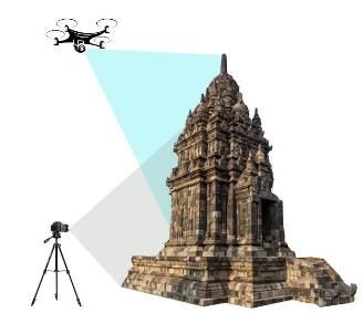
to fit with a specific field such as architecture [13]. (Fig. 1) [18] with various devices such as DSLR and
The adoption of this CRP gives a new possibility in the Unmanned Aerial Vehicle (UAV) [19].
the digital image processing by using less equipment. Using photogrammetry will push forward and
At least, CRP requires a camera, personal computer expand architectural methods in the documenting-
and scale bar to obtain a 3D image [14]. The built environment. As a digital form of technology,
application of CRP in architecture is a non-intrusive the photogrammetry offers more flexibility to manage
technique in documenting and producing a 3D model. images and essential measurement for architectural
Conventionally, the documenting and 3D image have analysis and documentation methodologies [20]. The
collected from 2D technics such as sketch and photogrammetry can generate a geometric of a
mechanical drawing following up to vector and precise model and architectural representation in
massing software. limited time [21] and makes the process of survey
In contrast, the photogrammetry sequentially short, free of danger and mistakes [22] [23]. The
generates serial images to points cloud that can photogrammetry also opens to develop and combine
conduct in fast and accurate detail of the 3D object. with other BIM software [24]. Therefore, the
As digitally formed, a virtual model of CRP architectural photogrammetry is not going to replace
represents existing built forms and possibly used to conventional method in image acquisition. Instead, it
100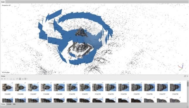
International Journal of GEOMATE, May., 2021, Vol.20, Issue 81, pp.100-105
helps architect in their works and the cheapest, devices; DSLR camera and drone (Fig. 2).
practical and suitable technique for the 3D
digitization and documentation.
Fig. 1 The configuration of the camera for image
acquisition
3. RESEARCH METHODOLOGY
The method in photogrammetry has organized in Fig. 2 The overlapping of the block images by Using
sequential steps. In this paper, close-range DSLR and Drone
photogrammetry has conducted in a two-step process.
The first step is capturing photographic images from Another fundamental parameter is image
various angles by using a DSLR camera and drone. distortion that is caused by reasons such as operator
This step is called the fieldwork phase applied to position, lenses-used, amount of light, the angel of the
collect quality and geometric information of the device, and assistive devices (Fig. 3). Therefore, in
images such as position, size, contrast, filtering and practical ways, the number of technical images
shape. This first step has much more relied on the skill captured are significant not only to reduce the
of the person who has operated the devices [18]. distortion [27] [28] but also to contribute to
The second step is to arranged the images by generating the density of the points cloud [29].
applying photogrammetry software to generate dense
cloud and texture data. The software is automatically
interpreting the semantic information of the image
[25]. This computational phase is sequentially run in
the software's workflow to obtain 3D images at the
end of the process.
The architectural site of this research was on the
Sewu Temple in Central Java, Indonesia. It has
focused on one of the hundreds of stupas. It has used
a Canon DSLR D-60 with an EF 50 mm f/1.4 USM Fig. 3 Acquiring Overlapped Images Using DSLR
lens with a tripod in acquisition images. The UAV Camera
used was a DJI Phantom 4 quadcopter drone equipped
with a camera 35 mm lens. In the cloud images As using a metric device, DSLR camera with
processes, this research has used an Agisoft metric attributes is an ideal tool to produce technical
Metashape Professional 64-bit software. A images. However, it is necessary to set lenses-used to
comparison of the device has also used Leica ensure consistency of the focal length. Therefore, the
RTC360 3D Laser Scanner with a tripod to produce a metric camera calibration [30] [31] needs to control
similar result. while collecting images. In practical ways, using
prime lenses or fixed lenses can avoid this control.
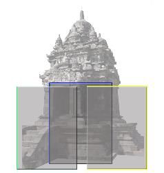
4. RESULT AND DISCUSSION Slightly different on a drone, as having a non-
metrical camera, it is necessary to use a drone with a
The field operator must understand several high-quality camera to ensure the image quality
technical parameters. The most basic setting is multi- produced [24]. A drone is a useful device to acquire
image restitution of a block of overlapping images fast and accurate images that cannot be captured on
and collinearity equations [26]. The block images certain positions by DSLR camera such as at a high-
must be arranged in between 60% to 80% overlaid on level place, large area, delicate angels [32] [33]. In
each image. This block means that the degree of practical ways, besides numbers and overlapping
overlapping is correlating to effects on detail images, it is also necessary for a drone operator to
obtained. In this research, the overlap is not only have a proper flight plan in avoiding an images
applied on the block images, but also between the overabundance (Fig. 4).
blocks. It means that two-block images are generated
horizontally and vertically in direction using two
101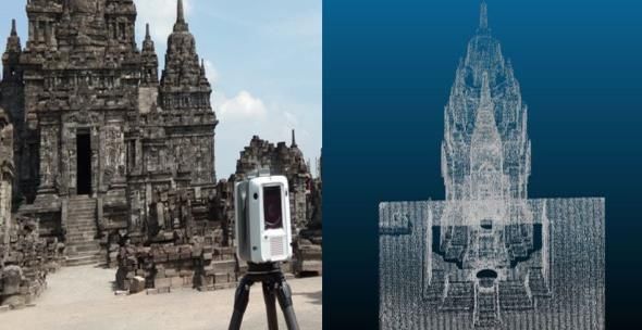
International Journal of GEOMATE, May., 2021, Vol.20, Issue 81, pp.100-105
In every phase, the photogrammetry software shows
the preferences dialogue command before
continuing the processing, giving a chance to correct
or adjust during the process. The last phase in the
photogrammetry software is exporting the result and
making the 3D model available to other software
such as BIM platform [35] [36] [37].
Fig. 4 Using Drone's Camera in Acquiring Image
Mosaics
All images that cameras have acquired then are
generated by photogrammetry software. There are
several alternatives software which can process the
image. The software is available for commercial and
open-source options based on computer skills and
requirements [34].
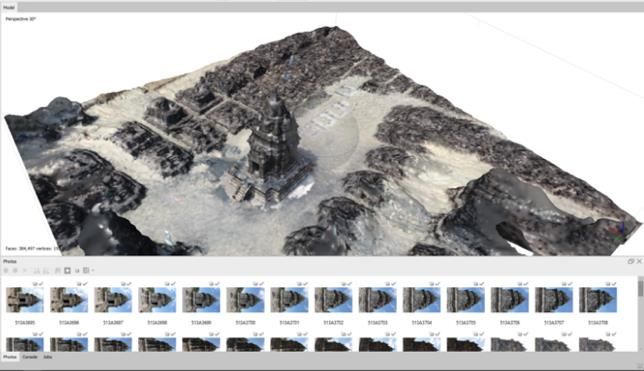
This generating process is following the workflow.
The workflow starts with aligning images. In this first
phase, the interface software shows a position and Fig. 7 Creating the Ortho-mosaic Images
orientation of images and builds a sparse a point cloud
model. From here, this earliest model displays two From the whole process, this close-range
groups of arranged images on the main windows, and photogrammetry (CRP) shows more advantageous
sources images on the bottom pane (Fig. 5). than conventional methods (Fig. 8). CRP can be
conducted in limited time to obtain a 3D model [22]
[38]. The photogrammetry process can also be
accurately recovered regardless of the size of the
object [39].
Fig. 5 Aligning Images in Photogrammetry Software
The next phases are sequentially building dense
point cloud and building mesh (3D polygonal model)
(Fig. 6).
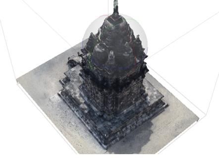
Fig. 8 The Result of Point Cloud 3D Model
As a comparison of the result, this research has
also used a laser scanner device on the same research
object (Fig. 9 left). The laser scanner can produce a
significant volume of points cloud (Fig. 9 right) and
generates very great detail in fast and precision both
on an object and large area [19]. For this reason, the
laser scanner still the best device in documenting field
data until today. However, as a part of its advantage,
this device's price is still high, and for maintaining
Fig. 6 Generating a Point Cloud Model
and routines, calibration makes laser scanner less
practical and economical. Therefore, it is necessary to
The process has continued to build texture, build
provide a low-cost alternative method and practice
a tiled model, build a digital elevation model using close-range photogrammetry.
(DEM), and build ortho-mosaic (Fig. 7).
102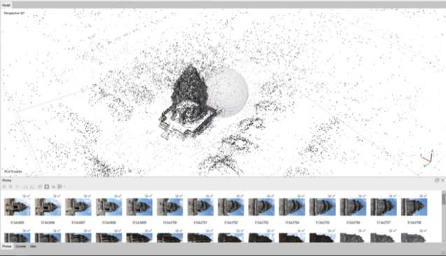
International Journal of GEOMATE, May., 2021, Vol.20, Issue 81, pp.100-105

                                                                      10.3923/itj.2009.202.207.
                                                               [5]    Westoby. M. J., Brasington. J., Glasser. N. F.,
                                                                      Hambrey. M. J., and Reynolds. J. M.,
                                                                      "Structure-from-Motion photogrammetry: A
                                                                      low-cost, effective tool for geoscience
                                                                      applications," Geomorphology, vol. 179, pp.
                                                                      300–314,         Dec.       2012,        DOI:
                                                                      10.1016/j.geomorph.2012.08.021.
Fig. 9 Using Laser Scanner Device (left) and Point             [6]    Han. J., Hong. K. and Kim. S., "Application
       Cloud Model (right)                                            of a Photogrammetric System for Monitoring
                                                                      Civil Engineering Structures," 2012.
5. CONCLUSION                                                  [7]    Evin. A., "The use of close-range
                                                                      photogrammetry in zooarchaeology: Creating
    The close-range photogrammetry (CRP) overs                        accurate 3D models of wolf crania to study
architecture efficiency in the time process and gave                  dog domestication," J. Archaeol. Sci.
alternative and valuable method in obtaining a                        Reports, vol. 9, pp. 87–93, Oct. 2016, DOI:
complete exterior of an architectural model. From this                10.1016/j.jasrep.2016.06.028.
paper, a combination of DSLR camera, drone and the             [8]    Remondino. F., "Heritage recording and 3D
photogrammetry software shows the 3D architectural                    modelling with photogrammetry and 3D
model produced can be generated from a natural                        scanning," Remote Sens., vol. 3, no. 6, pp.
setting into a high technical accuracy detail.                        1104–1138,         Jun.      2011,       DOI:
    However, due to less familiarity with the software                10.3390/rs3061104.
workflow, the photogrammetry becomes less used in
                                                               [9]    Morita. M. and Bilmes. G., "Applications of
the practice of obtaining information in architectural                low-cost 3D imaging techniques for the
objects. The software also requires mastery of more                   documentation of heritage objects," Opt.
advanced software to process further architectural                    Pura y Apl., vol. 51, no. 2, pp. 1–11, 2018,
models that have produced to be compatible with                       DOI: 10.7149/OPA.51.2.50026.
other fields.                                                  [10]   Nakano. K. and Chikatsu. H., "Camera-
                                                                      variant calibration and sensor modelling for
6. REFERENCES                                                         practical photogrammetry in archaeological
                                                                      sites," Remote Sens., vol. 3, no. 3, pp. 554–
[1]     Hemmleb. M. and Wiedemann. A., "Digital
                                                                      569, Mar. 2011, DOI: 10.3390/rs3030554.
        Rectification     And     Generation      Of           [11]   Murtiyoso. A., Remondino. F., Rupnik. E.,
        Orthoimages          In        Architectural                  Nex. F. and Grussenmeyer. P., "Oblique
        Photogrammetry," in IAPRS, 1997, vol.                         aerial photography tool for building
        XXXII, pp. 261–267, [Online]. Available:
                                                                      inspection and damage assessment," in
        https://www.researchgate.net/publication/23
                                                                      International       Archives       of      the
        54891.                                                        Photogrammetry, Remote Sensing and
[2]     Grussenmeyer. P. and Al Khalil. O., "From                     Spatial Information Sciences - ISPRS
        metric image archives to point cloud
                                                                      Archives, 2014, vol. 40, no. 1, pp. 309–313,
        reconstruction: Case study of the great                       DOI: 10.5194/isprsarchives-XL-1-309-2014.
        mosque of Aleppo in Syria," in International           [12]   Núñez. M. A., and Pozuelo. F. B., “Evolution
        Archives of the Photogrammetry, Remote                        of     the    architectural   and     heritage
        Sensing and Spatial Information Sciences -                    representation,” Landsc. Urban Plan., vol. 91,
        ISPRS Archives, Aug. 2017, vol. 42, no.                       no. 2, pp. 105–112, Jun. 2009, doi:
        2W5, pp. 295–301, DOI: 10.5194/isprs-                         10.1016/j.landurbplan.2008.12.006.
        archives-XLII-2-W5-295-2017.                           [13]   Hanke. K. and Ebrahim. M., "Monument
[3]     Barsanti. S. G., Remondino. F. and Visintini.                 Presentation Using Digital Architectural
        D., "3D SURVEYING AND MODELING                                Photogrammetry," 1997. [Online]. Available:
        OF ARCHAEOLOGICAL SITES," in ISPRS                            https://www.researchgate.net/publication/23
        Annals of the Photogrammetry, Remote                          6155255.
        Sensing and Spatial Information Sciences,              [14]   Murtiyoso. A. and Suwardhi. D., “Teknik
        Volume II-5/W1, 2013 XXIV International                       Pencocokan Citra dalam Fotogrametri untuk
        CIPA Symposium, 2 – 6 September 2013,                         Dokumentasi Cagar Budaya Indonesia
        Strasbourg, France, 2013, pp. 145–150.
                                                                      Banana Biodiversity and Biogeography Big
[4]     Yakar. M., Yilmaz. H. M., Gülec. S. A., and                   Data View project DBAT-The Damped
        Korumaz. M., "Advantage of digital close-                     Bundle Adjustment Toolbox in Matlab View
        range photogrammetry in drawing of                            project,” in Bunga Rampai Forum Peneliti
        muqarnas in architecture," Inf. Technol. J.,                  Muda Indonesia 2017, 2017.
        vol. 8, no. 2, pp. 202–207, 2009, DOI:

                                                         103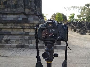
International Journal of GEOMATE, May., 2021, Vol.20, Issue 81, pp.100-105

[15]   Alby. E., Grussenmeyer. P., Perrin. J. P.,                     DOI: 10.3390/su10072259.
       "Integration         of      Close      Range           [25]   Wiedemann. A., "From Analogue To Digital
       Photogrammetric Survey in the Design                           Close-Range        Photogrammetry,"      1998.
       Process of Architectural Projects, New                         [Online].                            Available:
       perspectives to save Cultural Heritage," in                    https://www.researchgate.net/publication/23
       XIXth CIPA International Symposium, Oct                        32200.
       2003, Antalya, Turkey, 2003, pp. 46–51,                 [26]   Alexandru. A. and Popescu. G., "Introduction
       [Online]. Available: https://halshs.archives-                  in Architectural Photogrammetry," 2016.
       ouvertes.fr/halshs-00263999.                            [27]   Karras. G., Petsa. E., Karras. G. E.,
[16]   Murtiyoso. A. and Grussenmeyer. P.,                            Mountrakis. G., Patias. P. and Petsa. E.,
       "Virtual disassembling of historical edifices:                 "Modeling Distortion Of Super-Wide-Angle
       Experiments and assessments of an automatic                    Lenses For Architectural And Archaeological
       approach for classifying multi-scalar point                    Applications SAVEMEDCOASTS (Sea
       clouds into architectural elements," Sensors                   level rise scenarios along the Mediterranean
       (Switzerland), vol. 20, no. 8, Apr. 2020, DOI:                 coasts),"     2001.     [Online].    Available:
       10.3390/s20082161.                                             https://www.researchgate.net/publication/23
[17]   Grieco. G., "Integrating digital and                           57325.
       conventional recording techniques for the               [28]   Sužiedelytė-Visockienė. J., Bagdžiūnaitė. R.,
       documentation and reconstruction of an 18th-                   Malys. N. and Maliene. V., "Close-range
       Century wooden ship from Alexandria, VA,"                      photogrammetry enables documentation of
       Digit. Appl. Archaeol. Cult. Herit., vol. 16,                  environment-induced          deformation     of
       Mar.                  2020,               DOI:                 architectural heritage," Environ. Eng. Manag.
       10.1016/j.daach.2020.e00136.                                   J., vol. 14, no. 6, pp. 1371–1381, 2015, DOI:
[18]   Grussenmeyer. P., Hanke. K, and Streilein.                     10.30638/eemj.2015.149.
       A., “Architectural photogrammetry,” in                  [29]   Kwiatek. K. and Tokarczyk. R., "Immersive
       Digital Photogrammetry, 2002, pp. 300–339.                     photogrammetry         in    3D     modelling,"
[19]   Hoon. Y., J., and Hong. S., "Three-                            Geomatics Environ. Eng., vol. 9, no. 2, p. 51,
       dimensional digital documentation of cultural                  2015, DOI: 10.7494/geom.2015.9.2.51.
       heritage site based on the convergence of               [30]   Luhmann. T., Fraser. C. and Maas. H. G.,
       terrestrial laser scanning and unmanned aerial                 "Sensor modelling and camera calibration for
       vehicle photogrammetry," ISPRS Int. J. Geo-                    close-range photogrammetry," ISPRS J.
       Information, vol. 8, no. 2, Jan. 2019, DOI:                    Photogramm. Remote Sens., vol. 115, pp.
       10.3390/ijgi8020053.                                           37–46,          May          2016,        DOI:
[20]   Fortenberry. B. R., "Digital Documentation                     10.1016/j.isprsjprs.2015.10.006.
       in Vernacular Arch.pdf," Build. Landsc., vol.           [31]   Balletti. C., Guerra. F., Tsioukas. V. and
       26, no. 2, 2019.                                               Vernier. P, "Calibration of action cameras for
[21]   Middleton. W., Shu. Q. and Ludwig. F.,                         photogrammetric          purposes,"    Sensors
       "Photogrammetry as a tool for living                           (Switzerland), vol. 14, no. 9, pp. 17471–
       architecture," in International Archives of the                17490,          Sep.         2014,        DOI:
       Photogrammetry, Remote Sensing and                             10.3390/s140917471.
       Spatial Information Sciences - ISPRS                    [32]   Achille. C., "UAV-based photogrammetry
       Archives, 2019, vol. 42, no. 2/W17, pp. 195–                   and integrated technologies for architectural
       201, DOI: 10.5194/isprs-archives-XLII-2-                       applications—methodological strategies for
       W17-195-2019.                                                  the after-quake survey of vertical structures
[22]   Karabörk. H., Yaldiz. E. and Karasaka. L.,                     in Mantua (Italy)," Sensors (Switzerland),
       "3D documentation of portal muqarnases in                      vol. 15, no. 7, pp. 15520–15539, Jun. 2015,
       Anatolian Madrasahs with digital close-range                   DOI: 10.3390/s150715520.
       photogrammetric         method,"      Mediterr.         [33]   Murtiyoso. A., Grussenmeyer. P., Koehl. M.
       Archaeol. Archaeom., vol. 17, no. 3, pp. 137–                  and Freville. T, "Acquisition and processing
       148, 2017, DOI: 10.5281/zenodo.1005534.                        experiences of close range UAV images for
[23]   Morita. M. and Bilmes. G., "Applications of                    the 3D modelling of heritage buildings," in
       low-cost 3D imaging techniques for the                         Lecture Notes in Computer Science
       documentation of heritage objects," Opt.                       (including subseries Lecture Notes in
       Pura y Apl., vol. 51, no. 2, pp. 1–11, 2018,                   Artificial Intelligence and Lecture Notes in
       DOI: 10.7149/OPA.51.2.50026.                                   Bioinformatics), vol. 10058 LNCS, Springer
[24]   Sun. Z. and Zhang. Y., "Using drones and 3D                    Verlag, 2016, pp. 420–431.
       modelling to survey Tibetan architectural               [34]   Bemis. S. P., "Ground-based and UAV-
       heritage: A case study with the multi-door                     Based photogrammetry: A multi-scale, high-
       stupa," Sustain., vol. 10, no. 7, Jun. 2018,                   resolution mapping tool for structural

                                                         104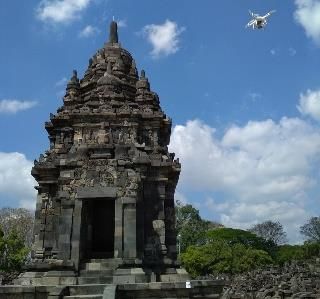
International Journal of GEOMATE, May., 2021, Vol.20, Issue 81, pp.100-105

       geology and paleoseismology," J. Struct.                [38]   İncekara. A. H., "Examing the Potential and
       Geol., vol. 69, no. PA, pp. 163–178, 2014,                     Limitation of Close-Range Photogrammetry
       DOI: 10.1016/j.jsg.2014.10.007.                                within Scope of Façade Improvement
[35]   Macher. H., Landes. T. and Grussenmeyer.                       Automatic 3D Shoreline Extraction and
       P., "Point clouds segmentation as base for as-                 Analysis From UAV and UAV-LIDAR Data
       built BIM creation," in ISPRS Annals of the                    For Sustainable Shoreline Monitoring: Case
       Photogrammetry, Remote Sensing and                             Study of Terkos Istanbul View," 2018.
       Spatial Information Sciences, Aug. 2015, vol.                  [Online].                         Available:
       2, no. 5W3, pp. 191–197, DOI:                                  https://www.researchgate.net/publication/33
       10.5194/isprsannals-II-5-W3-191-2015.                          9030918.
[36]   Stober. D., Žarnić. R., Penava. D., Turkalj. D.         [39]   Remondino. F. and El-hakim. S, "Image-
       and Virgej-Đurašević. R., "Application of                      based     3D    modelling:    A     review,"
       HBIM as a Research Tool for Historical                         Photogramm. Rec., vol. 21, no. 115, pp. 269–
       Building Assessment," Civ. Eng. J., vol. 4,                    291,      2006,    DOI:     10.1111/j.1477-
       no. 7, p. 1565, Jul. 2018, DOI: 10.28991/cej-                  9730.2006.00383.x.
       0309195.
[37]   El-Wahab. H. A., Bakr. A. F., and Raslan. R.
       A., "Towards a parametric plug-in for the
       conservation of built heritage," Alexandria              Copyright © Int. J. of GEOMATE. All rights reserved,
                                                                including the making of copies unless permission is
       Eng. J., vol. 58, no. 1, pp. 325–331, Mar.
                                                                obtained from the copyright proprietors.
       2019, DOI: 10.1016/j.aej.2018.12.001.

                                                         105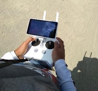
You can also read