Areas and population groups in Pakistan most exposed to combined effects of climate change, food insecurity and COVID-19
←
→
Page content transcription
If your browser does not render page correctly, please read the page content below
Helpdesk Report

Areas and population groups in
Pakistan most exposed to combined
effects of climate change, food
insecurity and COVID-19
Iffat Idris
GSDRC, University of Birmingham
8 March 2021

Question
Which areas and population groups in Pakistan are most exposed to the combined effects of
climate change and natural disasters, food insecurity and chronic malnutrition, and COVID-19?
Identify districts which are most vulnerable to the combined effects of these three risks. Also
identify gaps in the evidence base.

Contents
1.   Summary
2.   Climate change and natural disasters
3.   Food insecurity and malnutrition
4.   COVID-19
5.   Population groups at risk
6.   References

The K4D helpdesk service provides brief summaries of current research, evidence, and lessons
learned. Helpdesk reports are not rigorous or systematic reviews; they are intended to provide an
introduction to the most important evidence related to a research question. They draw on a rapid desk-
based review of published literature and consultation with subject specialists.

Helpdesk reports are commissioned by the UK Foreign, Commonwealth, and Development Office and
other Government departments, but the views and opinions expressed do not necessarily reflect those
of FCDO, the UK Government, K4D or any other contributing organisation. For further information,
please contact helpdesk@k4d.info.
1. Summary
There are strong interlinkages between the effects of climate change and natural disasters in
Pakistan, food insecurity, and exposure to COVID-19.1 Areas/groups at risk of one will often be
at risk of the others as well, demonstrating the complexities and multifaceted nature of
vulnerability, risk and exposure. In areas exposed to natural disasters, for example, there are
likely to be higher levels of food insecurity. Key geographic areas at risk of the combined effects
of climate change-natural disasters and food insecurity in Pakistan are Balochistan, Sindh,
southern Punjab and parts of Khyber Pakhtunkhwa (KP). With the exception of Balochistan due
to its very low population density, these are all also regions at high risk of COVID-19. Key
population groups especially at risk are the poor and landless, and women. The poor, in
particular, lack the capacity to adapt or recover from climate change impacts and natural
disasters, face difficulties in accessing adequate food, and often live/work in conditions which
promote transmission of COVID-19.

This rapid review looks at areas and population groups in Pakistan most exposed to the
combined effects of climate change and natural disasters, food insecurity and malnutrition, and
COVID-19. The review draws on a mixture of academic and grey literature, including reports by
development organisations. While considerable information was found about the diverse effects
of climate change and natural disasters on different parts of the country (including down to
district level), data on food insecurity was largely only at provincial level. There are also
significant gaps in the evidence base on specific population groups, notably religious minorities.

Key findings are as follows:

Climate change and natural disasters
    ▪ Pakistan is among the countries in the world most affected by climate change. Impacts
      already being seen include more frequent and intense extreme weather events, rising
      temperatures, water scarcity, reduced forest cover, and rising sea levels.
    ▪ Climate change effects are predicted to intensify in coming years. Pakistan is forecast to
      reach absolute water scarcity (per capita annual water availability of 1,000 cubic metres) by
      2025 (Baloch, 2018).
    ▪ Natural disasters which are most common in Pakistan are floods, drought, cyclones,
      earthquakes, landslides and avalanches. The country has seen repeated such disasters in
      recent years, which have displaced civilian populations and caused massive damage to
      property, crops and infrastructure, setting back development and growth. Virtually all areas
      of the country are at risk of natural disasters, though which natural disasters vary from one
      area to the next, reflecting Pakistan’s diverse topography and climate.
       o Floods – Floods are the most frequent recurring natural disaster in Pakistan. The country
         is at risk of glacial lake outburst floods (GLOF) and flash floods (hill torrents) in the north,
         riverine flooding along the Indus River basin in Punjab and Sindh, and coastal flooding in
         the south.
       o Droughts – Most of Balochistan is at risk of drought, as well as Sindh and southern
         Punjab. Droughts build up over long periods, and their effects can last for many years.

1 For definitions of key terms used in this review, e.g. disaster, exposure, vulnerability, see United Nations Office
for Disaster Risk Reduction (UNDRR) Terminology: https://www.undrr.org/terminology.

2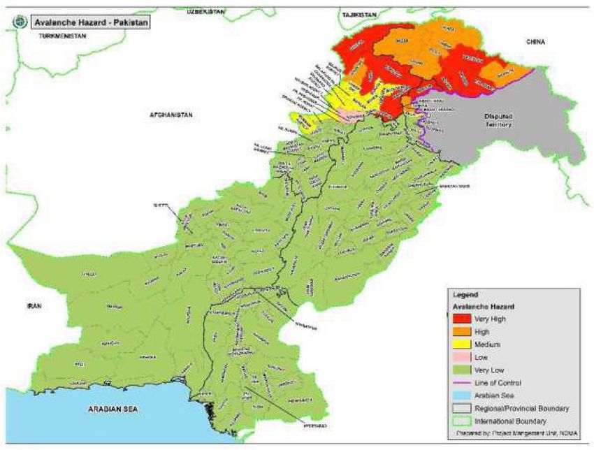
o Cyclones – Vulnerable districts are all found along the coast in Sindh and Balochistan.
       o Earthquakes – Pakistan lies in a seismic belt where two tectonic plates meet, so suffers
         frequent small and medium intensity earthquakes. Most at risk are districts in KP, as well
         as Pakistan Administered Kashmir (PAK) and Gilgit-Baltistan.
       o Landslides and avalanches – These also largely affect northern areas of the country:
         parts of KP, Gilgit-Baltistan and PAK. Vulnerability to landslides is exacerbated by high
         deforestation rates, cultivation and unplanned construction.
    ▪ Karachi merits particular attention because it is Pakistan’s economic hub and is highly
      vulnerable to climate change effects, notably rising sea levels and increased salinity. Large
      numbers of people displaced by climate change effects in surrounding areas have migrated
      to the city, adding to the load on already over-burdened services and resources. Water
      scarcity is especially acute in Karachi.
Food insecurity and malnutrition
    ▪ Pakistan is a food surplus country in terms of production (including wheat, rice, fruits,
      vegetables, milk and meat) but despite this, is largely a food insecure country. Key
      indicators of food insecurity are Prevalence of Undernourishment (PoU) and Prevalence of
      Moderate and Severe Food Insecurity. The former assesses how many people lack dietary
      energy, while the latter also looks at access to nutritious and sufficient food.
    ▪ PoU in Pakistan has remained at around 20% since 2007-9, but has increased in absolute
      terms (to 40 million in 2016-18) because of population growth as well as droughts (FAO et
      al, 2020: 8). PoU is highest in Balochistan, followed by Sindh and Punjab, and lowest in KP.
      PoU is consistently lower in rural areas than urban areas.
    ▪ In 2018, 23.5% of households in Pakistan were estimated to be either moderately or
      severely food insecure, while 10.1% were severely food insecure. The prevalence of both
      moderate or severe food insecurity, and severe food insecurity was highest in Balochistan
      (38.4% and 21.4% respectively) followed by Sindh (33.3% and 14.7% respectively). Both
      are also higher in rural than urban areas (FAO et al, 2020: 17-18).
    ▪ Key indicators of malnutrition are stunting, wasting and underweight among children under
      five years of age. Pakistan is estimated to have 12 million stunted children, at a national rate
      of 40.2%. Stunting prevalence is slightly lower among boys than girls, but significantly higher
      in rural areas than urban areas. Among the four provinces, it was highest in Balochistan
      (46.6%), followed by Sindh (45.5%), KP (40.0%) and Punjab (36.4%) (FAO et al, 2020: 23).
    ▪ Childhood wasting nationally was 17.7% in 2018, with prevalence higher among boys than
      girls, and in rural areas than urban areas. Among the provinces, it was highest in Sindh
      (23.3%) – reflecting the recurring dry spell in southern parts of the province - followed by
      Balochistan (18.9%) (FAO et al, 2020: 24).
    ▪ Underweight prevalence was 28.9% nationally in 2018, but much higher in Sindh (41.3%)
      followed by Balochistan (33.7%) (FAO et al, 2020: 26-27).
    ▪ Climate change effects and natural disasters strongly impact food insecurity, leading to both
      reduced agricultural productivity and reduced purchasing power. In the past year torrential
      monsoon rains in Sindh, Balochistan and northern Pakistan, and a massive desert locust
      infestation in Sindh, Balochistan and Punjab, have caused extensive damage to crops, with
      negative effects on food availability and accessibility.

3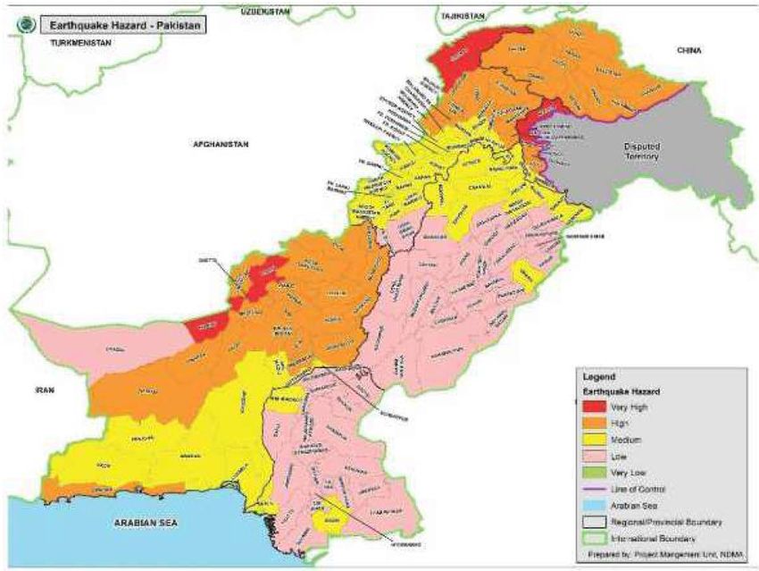
COVID-19
    ▪ The COVID-19 pandemic has been relatively limited in Pakistan, in terms of cases and
      deaths. As of 4 March 2021, the country had a total of 585,435 cases and 13,076 deaths.2
    ▪ Calculation of exposure risk to COVID-19 in different parts of Pakistan - based on population
      density, proximity to others in the household, and access to water, sanitation and hygiene
      (factors that contribute to/prevent the spread of COVID-19) - identifies Sindh, southern
      Punjab and KP as the areas at highest risk.
Population groups
Poor and landless
    ▪ Climate change and natural disasters hit the poor hardest because they have the least
      capacity to respond (to adapt and to recover). Exposure and vulnerability are also unequal in
      a community, reflecting powerlessness and poverty. For example, the poor tend to have
      homes in low-lying areas made of less durable materials (e.g. mud), while the affluent are
      usually on higher ground beyond inundation zones, in solid (e.g. brick) houses.
    ▪ Food insecurity is a function of four dimensions, including accessibility of food. Poverty
      directly impacts this. While overall multidimensional poverty in Pakistan has fallen in recent
      years, there are significant regional differences: it is high in Balochistan and Sindh, as well
      as parts of KP and southern Punjab, and higher in rural areas than urban areas.
    ▪ The poor are most at risk of COVID-19 infection because of the conditions in which they live
      and work (e.g. crowded neighbourhoods) and are also most vulnerable to the wider
      socioeconomic effects of the pandemic. Rise in multidimensional vulnerability (including
      effects on jobs, education, etc.) due to the pandemic is forecast to be highest in Punjab and
      Sindh; Balochistan and KP already have high rates of multidimensional poverty and food
      insecurity. The latter is forecast to rise in the pandemic, due to higher prices and reduced
      purchasing power.
    ▪ There is also correlation between multidimensional vulnerability and natural disasters: most
      districts in which the former is high have experienced recent natural shocks, which mean
      poverty and food insecurity levels are already high, and community resilience low. The
      highest correlation is seen in Balochistan, Sindh, southern Punjab and parts of KP.
Women
    ▪ As in other developing countries, patriarchal norms and lack of gender equality mean that
      women in Pakistan are disproportionately affected by climate change and natural disasters:
      they are at more risk of dying, have to spend more time on chores such as collecting water,
      face loss of livelihoods, can end up carrying the household burden as men migrate in seek
      of work, or face difficulties following displacement.
    ▪ The effects of food insecurity are particularly dire on poor women and children: in Pakistan
      50.4% of women are anaemic, up to 46% experience Vitamin A deficiency, and an average
      of 40% have iron deficiency (compared to a global average of 17%) (FAO & WFP, 2020: 1).
    ▪ Women in Pakistan are highly vulnerable to the wider negative effects of the pandemic, such
      as loss of livelihoods, discontinuation of reproductive and other healthcare, increased unpaid
      work responsibilities, increased food shortages, and domestic violence.

2   https://www.worldometers.info/coronavirus/country/pakistan/

4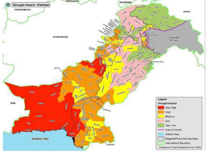
2. Climate change and natural disasters
Climate change effects in Pakistan
The Global Climate Risk Index (CRI) analyses quantified impacts of extreme weather events,
both in terms of fatalities and economic losses, and ranks countries from highest (most impacted
by extreme weather events) to lowest (Eckstein et al, 2021). While Pakistan was not ranked in
the CRI top ten countries most affected by climate change in 2019, it ranks 8th in the countries
most affected between 2000 and 2019, based on average values over a 20-year period (Eckstein
et al, 2021: 13). These countries can be divided into two groups: those most affected due to
exceptional catastrophes, and those affected by extreme events on an ongoing basis. Pakistan
falls into the latter group. Impacts of climate change already being seen include (ADB, 2017: 3):
    ▪   increase in the frequency and intensity of extreme weather events, along with erratic
        monsoon rains, causing frequent and intense floods and droughts;
    ▪   rising temperatures leading to enhanced heat and water-stressed conditions, particularly
        in arid and semi-arid regions, and thus reduced agricultural productivity;
    ▪   further decrease in already scant forest cover;
    ▪   rising sea levels threatening coastal areas;
    ▪   increased cyclones.

Natural disasters which are most common in Pakistan are floods, drought, cyclones,
earthquakes, landslides and avalanches (GoP, 2019; Ullah, 2016). The country has seen
repeated such disasters in recent years, which have displaced civilian populations and caused
massive damage to property, crops and infrastructure, setting back development and growth.

Water scarcity is a huge and growing problem with very serious implications for Pakistan’s future.
The Indus River is the primary source of freshwater for most of Pakistan: as well as supplying
households and industries, water from the Indus supports 90% of the agriculture sector in the
country (Nesbit, 2018). Climate change and over-exploitation mean that water flow in the Indus is
considerably reduced. Between 1990 and 2015 per capita water availability in Pakistan declined
from 2,172 cubic metres per inhabitant, to 1,306 cubic metres (UNDP, 2016: 1). According to the
International Monetary Fund (IMF), Pakistan's per capita annual water availability is now 1,017
cubic metres — perilously close to the scarcity threshold of 1,000 cubic metres (Baloch, 2018).
Moreover, the country is forecast to reach absolute water scarcity by 2025 (Baloch, 2018).

Looking ahead, USAID (2017: 2) make the following forecasts for climate change in Pakistan:
    ▪   Increased temperatures of 1.4°–3.7°C by the 2060s and of 6.0°C by the 2090s, with
        projected increases higher during winter and in the north.
    ▪   Uncertain mean annual precipitation changes, with projected monthly rainfall changes
        ranging from a decrease of 20% to an increase of 41% by the 2090s.
    ▪   While large uncertainties remain, climate models point to increased rainfall from
        January–June and decreased from July–September.
    ▪   Decreased glacier volume and snow cover.
    ▪   Increased frequency and intensity of extreme climate events.
    ▪   Rise in sea levels of 30–80 cm by 2100.

5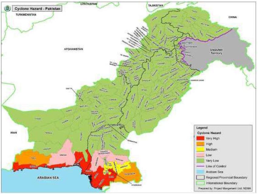
Areas at risk
As noted, the most common natural disasters (many related to climate change) are floods,
drought, cyclones, earthquakes, landslides and avalanches. These are not distributed evenly
across the country: some areas have experienced more of these and are at higher risk of these
than others, reflecting significant differences in climate and topography across Pakistan (Larsen
et al, 2014). Northern areas are most vulnerable to floods, landslides, avalanches and
earthquakes. Central regions and mid-river basins are primarily at risk of riverine flooding (see
below), while southern Punjab, southern Sindh and Balochistan are vulnerable to drought.
Coastal areas are prone to cyclones, tsunamis and coastal floods.
Floods
Pakistan is one of the most flood-prone countries in South Asia. Flooding is the most frequent
recurring natural disaster in Pakistan, with major flooding events occurring almost annually since
2000 (GoP, 2019: 30-31). These events cause massive damage: five major flood events
between 2010 and 2014 affected 38.12 million people and resulted in monetary losses of over
USD 18 billion (BTI, 2018: 27). The super-flood of 2010 alone killed 1,600 people, inundated an
area of 38,600 sq. km and caused damage of around USD 10 billion (ADB, 2017: 1). Floods are
also the only form of natural disaster affecting large areas across the entire country: from Skardu,
Chitral and Kotli in the far north, to Muzaffargarh and Sibi in the centre, and Lasbela, Thatta and
Karachi in the far south of the country. However, the cause and nature of flooding varies and can
be classified into four main categories (Larsen et al, 2014; GFDRR, 2011, Ullah, 2016):
▪ Riverine flooding - concentrated in the Indus River Basin, inundating low-lying flood
plains along the major rivers (Indus, Jhelum, Chenab, Ravi, Sutlej and Kabul) largely in
Punjab and Sindh where millions live. Riverine flooding is usually related to monsoon
rains, which occur in Pakistan between July and September.
▪ Flash floods - originate from highly localised convective rainfall or cloudbursts over small
to medium-sized basins in hilly terrains and along the foot of mountains and hills. Such
events are prevalent in Balochistan, KP and the northern areas.
▪ Glacial lake outburst floods (GLOFs)
▪ Coastal flooding associated with cyclone activity.
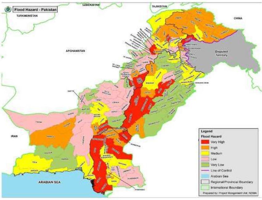
The National Disaster Management Authority (NDMA) has produced a district-wise map showing
flooding risk in the country (see Fig. 1). Districts considered most vulnerable to flooding in each
province are given in Table 1.
6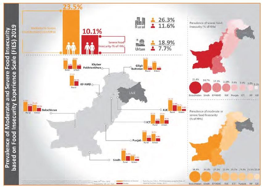
Fig. 1: Flooding hazard map of Pakistan

Source: GoP (2019, p. 32), licensed under a Creative Commons Attribution 4.0 International License.

Table 1: Districts most vulnerable to flooding

    Province                          Districts

    Balochistan                       Bolan, Chagai, Gwadar, Jaffarabad, Jhal Magsi, Kech, Kharan,
                                      Khuzfar, Lasbela, Nasirabad, Nushki, Sibi

    Khyber Pakhtunkhwa                Buner, Charsadda, Chitral, D. I. Khan, Dir Upper, Dir Lower, Kohistan,
                                      Kurram, Lakki Marwat, Malakand, Mansehra, Mardan, North
                                      Waziristan, Nowshera, Orakzai, Peshawar, Shangla, South Waziristan,
                                      Swabi, Swat, Tank

    Punjab                            Bakker, D.G. Khan, Gujranwala, Gujrat, Jhang, Khushab, Layyah,
                                      Mianwali, Muzaffargarh, Narowal, Rahimyar Khan, Ranjanpur,
                                      Rawalpindi, Sheikhupura, Sialkot

    Sindh                             Badin, Dadu, Ghotki, Jacobabad, Jamshoro, Kamber, Karachi,
                                      Kashmore, Khairpur, Larkana, Sanghar, Shahdadkot, Shikarpur,
                                      Sukker, T. M. Khan, Thatta

    Pakistan Administered             Bagh, Bhimber, Hattian, Haveli, Kotli, Muzaffarabad, Neelam, Poonch
    Kashmir (PAK)

    Gilgit-Baltistan                  Astore, Chilas, Diamer, Ghanche, Ghizer Hunza, Gilgit, Nagar, Skardu
Source: GoP (2019, p.31), licensed under a Creative Commons Attribution 4.0 International License.

7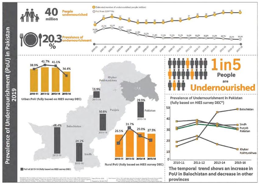
Drought
Drought is different from other natural disasters in that it can build up slowly over a period of
time, and its effects can linger for years afterwards (GoP, 2019: 32). Droughts in Balochistan and
Sindh in 2000 and 2002 severely affected over 3 million people: in 2001 economic growth fell
from an average of 6% to 2.6%; in Tharparkar (Sindh) many children died of malnutrition in 2014
after severely reduced rainfall from March 2013 to February 2014 (Larsen et al, 2014: 20). In
2015, an unprecedented heat wave with temperatures as high as 49°C killed more than 1,200
people in Karachi (USAID, 2017).

The NDMA has produced a district-wise map showing drought risk in the country (see Fig. 2).
Districts considered most vulnerable to drought in each province are given in Table 2. Much of
Balochistan is especially at risk, as well as Sindh and southern Punjab.

Fig. 2: Drought hazard map of Pakistan

Source: GoP (2019, p. 33), licensed under a Creative Commons Attribution 4.0 International License.

8
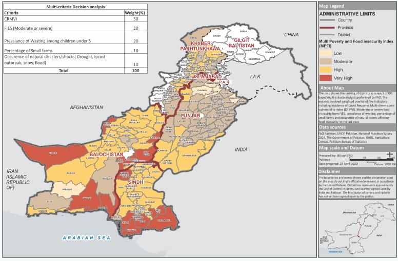
Table 2: Districts most vulnerable to drought

    Province                          Districts

    Balochistan                       Severe: Awaran, Gawader, Kech, Kharan, Nushki, Panjgure,
                                      Washuk
                                      Moderate: Chaghi, Killah Abdullah, Pishin

    Khyber Pakhtunkhwa                Chitral

    Punjab                            Severe: Bahawalnagar, Bahawalpur, Bhakkar, D. G. Khan,
                                      Muzaffargarh, Rajanpur, Rahimyar Khan
                                      Moderate: Attock, Chakwal, Jhelum, Khushab, Layyah, Mianwali

    Sindh                             Severe: Dadu, Jamshoro, Khambar, Shahdadkot, Tharparkar,
                                      Umerkot
                                      Moderate: Badin, Benazirabad, Karachi, Khairpur, Mirpurkhas,
                                      Thatta
Source: GoP (2019, p.33), licensed under a Creative Commons Attribution 4.0 International License.

Cyclones
The NDMA has produced a district-wise map showing cyclone risk in the country (see Fig. 3).
Districts considered most vulnerable to cyclones in each province are given in Table 3. These
are all found in coastal areas of Sindh and Balochistan.

Fig. 3: Cyclone hazard map of Pakistan

Source: GoP (2019, p. 32), licensed under a Creative Commons Attribution 4.0 International License.

9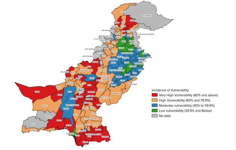
Table 3: Districts most vulnerable to cyclones

     Province                             Districts

     Balochistan                          Awaran, Gawader, Kech, Lasbela

     Sindh                                Badin, Hyderabad, Karachi, Sujawal, Thatta
Source: GoP (2019, p.37), licensed under a Creative Commons Attribution 4.0 International License.

Earthquakes
Pakistan lies within a seismic belt (where the Indo-Australian and Eurasian tectonic plates meet)
and therefore suffers from frequent small and medium magnitude earthquakes. The Hindu Kush
and Karakorum mountain ranges in the north and Koh-e-Suleiman range in the west are
particularly vulnerable, and the resulting devastation can be immense due to the poor
construction of buildings (Larsen et al, 2014). The 2005 earthquake in the north of the country led
to the loss of over 73,000 lives, and widespread damage to homes, infrastructure and so on, with
massive economic disruption (GoP, 2019: 28). The NDMA has produced a district-wise map
showing earthquake risk in the country (see Fig. 4). Districts considered most vulnerable to
earthquakes in each province are given in Table 4.

Fig. 4: Earthquake hazard map of Pakistan

Source: GoP (2019, p.30), licensed under a Creative Commons Attribution 4.0 International License.

10
Table 4: Districts most vulnerable to earthquakes
Province Districts
Balochistan Quetta
Khyber Pakhtunkhwa Abbottabad, Bajaur, Bannu, Charsadda, Chitral, Lower Dir,
Malakand, Mardan, Nowshera, Peshawar, Swat, Shangla,
Swabi
Punjab Gujrat, Narowal, Okara, Rawalpindi, Sialkot
Sindh Karachi
Pakistan Administered Bagh, Hattian, Haveli, Kotli, Muzaffarabad, Poonch,
Kashmir Sudhnoti
Gilgit-Baltistan Astore, Diamer, Gilgit, Ghanche
Source: GoP (2019, p.29), licensed under a Creative Commons Attribution 4.0 International License.
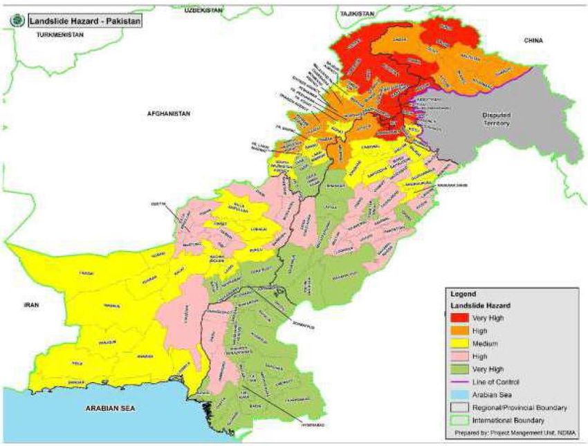
Avalanches and landslides
The NDMA has produced district-wise maps showing risk of avalanches and landslides in the
country (see Figs. 5 and 6 respectively). Districts considered most vulnerable to avalanches and
landslides in each province are given in Table 5. These are confined to Gilgit-Baltistan, northern
districts of KP and a few districts in PAK (PAK). Vulnerability to landslides is exacerbated by high
deforestation rates, cultivation and unplanned construction (Ullah, 2016: 129).
Table 5: Districts most vulnerable to avalanches
Province Districts
Khyber Pakhtunkhwa Chitral, Kohistan
Pakistan Administered Neelam, Hattian Bala
Kashmir (PAK)
Gilgit-Baltistan Astore, Gilgit, Ghanche, Ghizer, Skardu
Source: GoP (2019, p. 36), licensed under a Creative Commons Attribution 4.0 International License.
11Fig. 5: Avalanche hazard map of Pakistan Source: GoP (2019, p. 36), licensed under a Creative Commons Attribution 4.0 International License. Fig. 6: Landslide hazard map of Pakistan Source: GoP (2019, p. 35), licensed under a Creative Commons Attribution 4.0 International License. 12
Karachi
Karachi merits particular attention both because the effects of climate change and water scarcity
are particularly acute – and threatening – in the city, and because it is Pakistan’s vital economic
hub. Karachi is close to the Indus River Delta, where the Indus flows into the Arabian Sea. Rising
sea levels mean the delta is now almost at sea-level, with increasing salinity in creeks and
streams inland, negatively impacting local ecosystems and fresh water supplies, and reducing
availability of agricultural land. Some parts of the city are already submerged in the Arabian Sea,
and there are warnings that many other areas could follow within 35-45 years (Nazar, 2016).

These climate change effects are exacerbated by cutting down of the mangrove forests along the
coast: coverage has decreased from 400,000 hectares in 1945 to 70,000 hectares in 2016
(Nazar, 2016). The mangrove trees play a critical role in preventing coastal erosion and
minimizing the damage caused by cyclones and tsunamis: cutting them down has made Karachi
far more vulnerable to these. Other manmade developments having negative ecological effects
include the CPEC Port Qasim Power Project along the Arabian Sea coastline. Aimed at
alleviating the country’s energy crisis, the project has damaged critical ecosystems and
destroyed livelihoods of local people dependent on farming and fishing (Nazar, 2016).

Climate change – due to natural and manmade causes - has displaced an estimated 80% of the
five million Pakistanis who once lived along the banks of the Indus Delta (Nazar, 2016). Many of
those people have moved to Karachi, placing additional pressure on resources there. Karachi is
expanding rapidly – the urban footprint increased by a quarter between 2001 and 2013 – but this
is largely sprawl, without adequate investment in services and infrastructure, and not planned in
a way to prevent exposure to natural disasters (Javed & Nabi, 2018: 40, 44). Water is already a
scarce resource in the city: water availability in Karachi varies between four hours per day and
two hours every other day (Javed & Nabi, 2018: 40). Supply of water is in the hands of organised
mafias who charge exorbitant rates (Javed, & Nabi, 2018). Critically, water is already a major
source of conflict in Karachi, often taking place along (and aggravating) existing ethnic, religious
and caste fault lines (Mustafa et al, 2017).

Multi-hazard vulnerability and risk assessment
The UN Office for the Coordination of Humanitarian Affairs (OCHA) has also produced a map
showing vulnerability to multiple hazards in Pakistan (see Fig. 7). It covers floods, landslides,
cyclones, drought, landslides, avalanches and GLOF. This is dated from June 2016.

See: Fig. 7: Multi-hazard vulnerability and risk assessment, Source: UN Office for the Coordination of
Humanitarian Affairs (2016), https://reliefweb.int/map/pakistan/pakistan-multi-hazard-vulnerability-and-risk-
assessment-mhvra-27-june-2016

3. Food insecurity and malnutrition
Levels and regional disparities
Food insecurity
Pakistan is a food surplus country in terms of production. In general, Pakistan is net-surplus in
producing wheat, rice and other cereals, fruits and vegetables, milk and meat and net-deficient in

13
production of oil seeds and pulses (FAO & WFP, 2020: 11). Despite this, it is largely a food
insecure country. The Food and Agriculture Organization defines food insecurity as: ‘A situation
that exists when people lack secure access to sufficient amounts of safe and nutritious food for
normal growth and development and an active and healthy life’ (FAO et al, 2020: 14).

Consistent with the key indicators for Sustainable Development Goal 2 Zero Hunger, food
insecurity is measured in Pakistan using Prevalence of Undernourishment (PoU) and Prevalence
of Moderate and Severe Food Insecurity based on the Food Insecurity Experience Scale (FIES)
(FAO et al, 2020). The former, PoU, allows estimation of how many people lack dietary energy,
but does not give information about the quality of dietary energy. By contrast, the FIES does
allow estimation of how many people do not have access to nutritious and sufficient food, due to
lack of resources or other reasons (FAO et al, 2020: 7).

Fig. 8: Infographics on Prevalence of Undernourishment (PoU) in Pakistan (%)

Source: FAO et al, 2020: p. 15, licensed under Creative Commons 3.0 Intergovernmental Organization (IGO)

Figure 8 gives infographics showing scale and trends for PoU in Pakistan. Key numbers and
trends are as follows (FAO et al, 2020: 12-13):

     ▪   PoU in Pakistan fell from 25.8% in 2001-3, to 20.3% in 2016-18; the drop was more
         pronounced up to 2007-9, thereafter remaining at around 20%.

14
▪ Despite this reduction, the estimated Number of Undernourished people (NoU) increased
from 37.6 million in 2002-4 to 40 million in 2016-18, as a result of steady population
growth over the same period as well as series of climate-related disasters since 2008
(including floods in 2010-13 and drought in 2013-14 and 2017-18 in parts of Pakistan)
and high inflation from 2008-14.
▪ With regard to the provinces, PoU has fallen in Sindh, Punjab and KP since 2011-12, but
rose in Balochistan. In 2015-16 PoU was lowest in KP, followed by Punjab, Sindh and
highest in Balochistan.
▪ With regard to rural-urban areas, the proportion of the population in rural areas that is
undernourished is consistently lower than in urban areas.
Fig. 9: Infographics on Prevalence of Moderate or Severe Food Insecurity in Pakistan (% households)
Source: FAO et al, 2019: 21, licensed under Creative Commons 3.0 Intergovernmental Organization (IGO)
Figure 9 gives infographics for moderate or severe food insecurity in Pakistan, based on the
FIES, which looks at quality as well as energy content of diet. People experiencing moderate
food insecurity face uncertainties about their ability to obtain food, and have been forced to
compromise on the quality and/or quantity of the food they consume. People experiencing severe
15food insecurity have typically run out of food and, at worst, gone a day (or days) without eating
(FAO et al, 2020: 16). Key numbers for Pakistan are as follows (FAO et al, 2020: 17-18):
▪ In 2018, 23.5% of households in Pakistan were estimated to be either moderately or
severely food insecure, while 10.1% were severely food insecure.
▪ The prevalence of moderate or severe food insecurity was highest in Balochistan (38.4%)
followed by Sindh (33.3%) and by the Newly Merged Districts of KP3 (KP-NMD, 27.1%).
▪ The prevalence of severe food insecurity follows the same trend, being highest in
Balochistan (21.4%) followed by Sindh (14.7%) and KP-NMD (12.1%).
▪ There are significant rural-urban differences with both moderate or severe food insecurity
(26.3% in rural areas and 18.9% in urban areas) and severe food insecurity (11.6% and
7.7% respectively) being higher in rural than urban areas.
Malnutrition: stunting, wasting and underweight
Sustainable Development Goal 2, Target 2.2 calls for an end to all forms of malnutrition by 2030.
Malnutrition covers a broad spectrum ranging from severe undernutrition to overweight and
obesity (FAO et al, 2020: 21). Key indicators are stunting among children under five years of age,
wasting among children under five years of age, and underweight among children under five
years of age.
Stunting is a reflection of children failing to achieve their genetic potential for height, with stunted
children too short for their age. It is the cumulative effect of irreversible physical and cognitive
damage caused by chronic undernutrition, repeated infections and inadequate childcare and
feeding practices (FAO et al, 2020: 22). Key figures for stunting in Pakistan are as follows (FAO
et al, 2020: 22-23):
▪ Pakistan is estimated to have 12 million stunted children. This is higher than any other
country in South Asia, and the third highest figure in the world.
▪ The National Nutrition Survey 2018 found that the national rate of stunting was 40.2%
(four percentage points down from 2011).
▪ Stunting prevalence was slightly higher among boys (40.9%) compared to girls (39.4%),
but significantly higher in rural areas (43.2%) compared to urban areas (34.8%).
▪ Stunting was highest in children from households in the poorest quintile (50.4%) but a
substantial proportion were also stunted in the richest quintile (29.2%), pointing to the
fact that not only poverty, but also lack of knowledge as well as widespread deficiencies
in WASH, food safety and food quality are contributory factors.
▪ Among the four provinces, stunting prevalence was highest in Balochistan (46.6%),
followed by Sindh (45.5%), KP (40.0%) and Punjab (36.4%).
Childhood wasting is a reflection of acute malnutrition in children, with wasted children being too
thin for their height (FAO et al, 2020: 24). It is caused by recent nutritional deficiency due to
changes in availability of food and/or infectious diseases such as diarrhoea, and entails children
rapidly losing weight. Key figures for wasting in Pakistan are as follows (FAO et al, 2020: 24-25):
3Formerly the Federally Administered Tribal Areas (FATA); these were merged with Khyber Pakhtunkhwa
province in May 2018.
16▪ The National Nutrition Survey 2018 found that wasting prevalence in Pakistan was
17.7%.
▪ Wasting prevalence was higher among boys (18.4%) than girls (17.0%), and significantly
higher in rural areas (18.6%) than urban areas (16.2%).
▪ With regard to provincial differences, wasting prevalence was highest in Sindh (23.3%) –
reflecting the recurring dry spell in southern parts of the province, followed by Balochistan
(18.9%), Punjab (15.3%) and KP (15.0%). However prevalence was much higher in KP
Newly Merged Districts at 23.2%.
Key figures for underweight among children under five years of age in Pakistan are as follows
(FAO et al, 2020: 26-27):
▪ While high, the prevalence of underweight in Pakistan has fallen over the past two
decades, from 38% in 2001, to 31% in 2011 and 28.9% in 2018.
▪ However, there are significant provincial disparities, with prevalence of underweight
highest in Sindh (41.3%), followed by Balochistan (33.7%), Punjab (23.5%) and KP
(23.1%), though it was much higher in Newly Merged Districts of KP (33.7%).
Links between climate change-natural disasters and food insecurity
Key issues driving food insecurity and malnutrition are poverty, climate change impacts, recurring
disasters, crippling price inflation and political and economic instability (Sleet, 2019). The link
between poverty – probably the most important determinant - and food security is assessed in
Section 5 below. Also significant are the effects of climate change and natural disasters. Nearly
all arable land in Pakistan is cultivated, and production is dependent on a glacier- and snow-fed
irrigation network, making it extremely vulnerable to climate change. Agricultural productivity is
directly linked to food security. Effects of climate change on agriculture in Pakistan include
(USAID, 2017: 2):
▪ Reduced availability of irrigation water, limiting crop productivity;
▪ Altered growing periods, adversely affecting staple crops such as wheat, maize and rice
predominantly grown in the south of the country, leading to increased food prices;
▪ Damaged crops and rangelands from floods and droughts;
▪ Deteriorated agricultural land due to saline intrusion, soil erosion and waterlogging –
almost 2 million acres of arable land in the fertile Indus Delta have been lost due to saline
intrusion from the reduced river flows and rising seas;
▪ Reduced foreign exchange earnings and agricultural livelihood security;
▪ Decreased livestock productivity (due to higher temperatures and drought leading to heat
stress), reduced animal fodder production and increased stress on feed and water
sources.
Natural disasters, notably floods, can cause massive agricultural losses. In the past year
torrential monsoon rains inundated large agricultural lands in Sindh, Balochistan and northern
Pakistan. Reports from Sindh show that large proportions of cotton crops, chilli crops, onion
crops, and rice crops have been damaged because of the floods (WFP, 2020). Not only has this
caused heavy financial losses to the growers, but stagnant water in the farmlands is also
delaying efforts to treat the damaged lands or grow another crop. Moreover, destruction of roads
17and bridges also hampers the smooth transport of food and agricultural products to the markets. Also recently, a massive desert locust infestation has been devouring crops on farms across Sindh, Balochistan and Punjab. The FAO warns that losses to agriculture because of the locust infestations could reach PKR 353 billion (USD 2.2 billion) for rabi (winter-sown) crops and PKR 464 billion (USD 2.9 billion) for kharif (summer-sown) crops: the situation has been declared an emergency (Notezai & Rehman, 2020). Such loss of crops and of income has serious negative effects on food availability and accessibility – and thus on food security. 4. COVID-19 The COVID-19 pandemic has been relatively limited in Pakistan, in terms of cases and deaths. As of 4 March 2021, the country had a total of 585,435 cases and 13,076 deaths.4 Given the total population is over 200 million, these figures can be considered low. See: Figure 10: Areas in Pakistan at most risk of COVID-19, Source: https://fraym.io/pakistan_wb/ Exposure risk to COVID-19 across different parts of Pakistan is shown in Figure 10. The map was produced by the World Bank in collaboration with Fraym, a geospatial analysis firm. Exposure risk to COVID-19 is calculated based on an index which gives equal weighting to: population density; proximity to others in the household; and access to water, sanitation and hygiene. These reflect factors that contribute to/prevent the spread of COVID-19. Thus intergenerational households living in crowded dwellings, in high-density areas such as city slums, and with poor access to personal hygiene, will be at greater risk. As seen, Sindh, southern Punjab and KP are the areas at highest risk. As of January 2021, the burden of the pandemic has been concentrated in five major metropolitan areas: Rawalpindi, Islamabad, Lahore, Karachi and Peshawar (Cheema et al, 2021). 5. Population groups at risk The preceding sections in this review have highlighted the geographic areas most at risk from climate change and natural disasters, food insecurity and COVID-19. As seen, there is often strong overlap between these – southern Sindh, for example, is at high risk of droughts, flooding, has high rates of moderate or severe food insecurity and stunting, and is one of the areas in the country where COVID-19 risks are high. This overlap is not coincidental, but rather points to the strong linkages and mutually reinforcing effects of the different risks. Thus, for example, vulnerability to climate change and natural disasters increases risk of food insecurity. This section looks at population groups most at risk. The analysis below confirms the strong linkages between climate change-natural disasters, food insecurity and COVID-19 risk, which means that population groups at risk of one will likely be at risk of the others as well. 4 https://www.worldometers.info/coronavirus/country/pakistan/ 18
Poor and landless
The poor are most vulnerable to the effects of climate change and natural disasters, as well as to
food insecurity and COVID-19. A considerable body of literature on Pakistan has identified the
following rural groups as the poorest: landless households, sharecroppers and small landowners,
agricultural workers, construction workers, female-headed households, large households and
zakat (charitable donations in Islam) recipients (Ullah, 2016: 128).

Climate change and natural disasters
Climate change and natural disasters hit the poor hardest because they have the least capacity
to respond (to adapt and to recover) (Ullah, 2016). Exposure and vulnerability are unequal in a
community, and both reflect and contribute to powerlessness and poverty (Ullah, 2016).
Differences in land distribution and ownership structures in rural areas are significant factors in
poverty incidence and thus in vulnerability. Mustafa (cited in Ullah, 2016: 128) notes that the
poorest and landless people tend to have homes in low-lying areas of the main village, while
large landholders and affluent individuals are usually situated on higher ground beyond the main
inundation zones. Furthermore, in Pakistan houses in rural areas tend to be made from low cost,
easily available material with many being katcha (‘raw’ or ramshackle) of bamboo, mud, reeds,
etc. or semi-pukka (semi-solid) of a mix of durable (e.g. brick, cement) and non-durable (e.g.
mud, reeds) materials. Such houses are highly vulnerable to meteorological or geological
hazards in Pakistan (Maheri et al, cited in Ullah, 2016: 128). By contrast, more affluent people
have pukka (solid) houses of materials such as bricks, cement and concrete, which are far more
durable.

However, vulnerability to climate change and natural disasters in rural areas is also related to
sources of income. Thus, large landowners and small farmers report a significantly larger
percentage of loss of income (67% and 77% respectively) during flooding, than landless people
(41%) (Ullah, 2016: 128). This is because the latter will often have other, non-farming sources of
income).

Food insecurity and malnutrition
Food security/insecurity is a function of four dimensions: availability of food, accessibility of food,
utilization of food (if families are consuming food of adequate nutritive value), and stability (if
families are food secure at all time) (FAO et al, 2020: 14). Poverty directly impacts on
accessibility of food – whether or not families can afford the food they need. According to the
World Bank, incidence of under-five malnutrition (including stunting and wasting) in Pakistan ‘is
considerably higher among poorer quintiles’ of the expenditure distribution (cited in FAO et al,
2020).

Multidimensional poverty has fallen in Pakistan in recent years, from a headcount ratio of 55.2%
in 2004-05 to 38.8% in 2014-15 (FAO & WFP, 2020: 1). But a quarter of the population (around
53 million people) lives below the national poverty line5 (FAO & WFP, 2020: 5). Furthermore,
there are significant regional disparities, with the incidence of multidimensional poverty being

5PKR 3,030.3 per adult equivalent per month. Source: World Bank.
https://databank.worldbank.org/data/download/poverty/33EF03BB-9722-4AE2-ABC7-
AA2972D68AFE/Global_POVEQ_PAK.pdf

19
higher for rural areas (54.6%) than urban areas (9.6%), and as high as 71.2% in Balochistan
alone (FAO & WFP, 2020: 1). Districts with extreme poverty are mostly found in Balochistan,
Sindh, Khyber Pakhtunkhwa (KP) and southern Punjab (FAO & WFP, 2020: 5).

COVID-19
As seen, the poor are most at risk of COVID-19: their living conditions such as large households
in crowded spaces, increase the chances of transmission. The poor are also most vulnerable to
the knock-on negative effects of the pandemic, e.g. loss of livelihoods as many work in the
informal sector. UNDP (2020) has carried out an assessment of the likely socioeconomic impacts
of COVID-19. Figure 11 gives district-wise incidence of vulnerability based on a COVID-19
response multidimensional vulnerability index (CRMVI), which includes the economic,
educational and other effects of the pandemic.

Figure 11: Map of COVID-19 Response Multidimensional Vulnerability Index (CRMVI)

Source: UNDP, 2020: 13, reproduced with permission.

The UNDP assessment explains that the poorest of the poor are vulnerable and at risk during the
pandemic because of (UNDP, 2020: 22-23):
     ▪   limited skills, a lack of savings and dependence on daily wages;
     ▪   reduced economic activities – especially in the transportation, agriculture, trade and
         retain – and limited income generation opportunities;
     ▪   their concentration in the informal sector and lack of access to social protection;
     ▪   food shortages and food insecurity, resulting in malnutrition;
     ▪   the lack of a legal identity – including Computerized National Identity Cards (CNIC) –
         nationality and/or registration, especially for refugees and migrants.

20
With regard to provincial differences, the assessment notes (UNDP, 2020: 14):
▪ Punjab and Sindh may experience the highest increase in their multi-dimensionally
vulnerable populations. Given their high population density in both rural and urban areas,
the indicators that contribute the most to their CRMVI include overcrowding and a higher
dependency ratio. Other indicators that affect CRMVI include a lack of human capital
(lower years of schooling), fewer people earning more than the minimum wage, and
deprivation in livestock ownership as an alternate means of earning a livelihood. This is
coupled with a high incidence of food insecurity in many districts.
▪ Balochistan and Khyber Pakhtunkhwa may experience a more moderate increase in their
vulnerable populations. However, these provinces already have higher rates of
multidimensional poverty and food insecurity, and have large refugee communities.
The wider economic fallout of the pandemic is beyond the scope of this review, but in the context
of food insecurity, it is relevant to note that COVID-19 has negatively impacted families’ ability to
afford and access a nutritious, balanced diet. This reflects both soaring food prices due to
lockdowns, and decline in purchasing powers (FAO & WFP, 2020: 1). The UNDP socioeconomic
impact assessment highlights the correlation between CRMVI and food insecurity. It has
identified 34 districts in Pakistan as ‘Very High Vulnerability’ districts to food security during
COVID-19, and 43 as ‘High Vulnerability’ districts, in which about 67.8 million people live
collectively (UNDP, 2020: 14). At most risk to food insecurity during a pandemic are the poor
elderly, people with other chronic diseases and weak immune systems, people with disabilities,
and female-headed households who often face barriers in accessing government related
provisions due to issues in access (FAO & WFP, 2020: 1).
The UNDP assessment also highlights the links between CRMVI and natural disasters: ‘Except
for districts in northern Punjab, most districts with a higher CRMVI have experienced one or more
recent natural shocks. This means that poverty and food insecurity levels in districts already
classified as vulnerable by the CRMVI may worsen due to COVID-19, as recent natural shocks
have reduced communities’ resilience. This in turn, will cause a further deterioration in nutrition
indicators’ (UNDP, 2020: 13).
Figure 12 maps CRMVI along with food insecurity and occurrence of natural shocks/emergencies
in the previous year. In this analysis too, districts in Balochistan, Sindh, southern Punjab and
parts of KP are most at risk.
21Figure 12: Multi-criteria decision analysis for vulnerable, poor and food insecure districts
Source: UNDP, 2020: 18, reproduced with permission.
Women
Climate change and natural disasters
In many developing countries, women are disproportionately vulnerable to the effects of climate
change and natural disasters because their rights and socioeconomic status are not equal to
men, reflecting patriarchal norms and attitudes. An Oxfam brief on climate-induced displacement
highlights the various ways in which women are disproportionately impacted (Oxfam, 2019: 7-8)
▪ Cultural and social norms increase the vulnerability of women to climate shocks. In many
parts of the world, women do not learn to swim or are not able leave the house
unaccompanied, which puts them at greater risk from floods and storms.
▪ While women make up 43% of smallholder farmers, they do not have the same access to
credit, insurance or government support as men, making it harder to adapt or rebuild their
lives and livelihoods after a disaster.
▪ Women are often among the last to leave home when more extreme or erratic weather
makes it harder for families to put food on the table, staying behind to look after children
and elderly or sick relatives, while male family members leave to search for an income
elsewhere. This can place a huge burden on women, who often become the main
provider for the family as well as the primary caregiver.
▪ Their job is made harder by the climate crisis, which makes growing food and collecting
water and fuel more difficult and time-consuming.
▪ When forced to leave home, women and children are particularly vulnerable to violence
and abuse. For example, in Badin, Pakistan, women left displacement camps because of
22the uncomfortable and unsafe living conditions in camps.… Gender inequalities also
make it harder for displaced women to rebuild their lives.
A number of studies have been carried out looking at the gendered impact of climate change in
Pakistan’s Sindh province. Kayani (2017: 9) identifies some of the same factors as the Oxfam
brief, including: ‘women’s lack of property rights and land tenure means that they are often forced
to work on less productive land and are excluded from access to agricultural training services or
inputs that might enable them to diversify their livelihoods or increase their resilience to climate-
related shocks such as flooding or drought’. She cites the example of a small village in Dadu
District (Sindh), where women who practiced fishing, net weaving and other fishing-related
activities, suffered from reduced economic opportunities as the population of fish considerably
decreased over time due to changes in the weather (Kayani, 2017: 9). Hayat (2019) echoes
these findings on the gendered impact of climate change in Sindh, pointing to increased
competition for resources such as firewood and water meaning women have to spend more time
on these tasks, the greater risk of women being killed in disasters because they lack survival
skills such as swimming, the challenges of finding alternative sources of livelihoods, the dilemma
of migrating with men or staying behind, and the difficulties inherent in both.
Food insecurity and malnutrition
The effects of food insecurity are particularly dire on poor women and children (FAO & WFP,
2020: 1). Among women of reproductive age (WRA, age 15-49 years), the National Nutrition
Survey 2018 found that 14.5% of those assessed were underweight, while nearly half (46.4%)
had normal weight as per Body Mass Index (BMI), 24.2% were overweight, and 13.9% were
obese (FAO et al, 2020: 36). Regarding provincial distribution, the highest number of
underweight WRA were in Sindh (22.6%) while the least was found in KP-NMD (5.4%) where
obesity was more prevalent (23.2%) (FAO et al, 2020: 36). The prevalence of overweight was
also highest in KP (28.2%). There are strong correlations between wealth/poverty and
urban/rural location and underweight among WRA: underweight WRA largely belong to the
poorest quintiles, and are more likely to be in rural areas (FAO et al, 2020: 37).
Recent findings show that in Pakistan: 61.9% of young children and 50.4% of women are
anaemic; as much as 54% children and 46% women experience Vitamin A deficiency; and,
against the global average of 17%, the percentage of women with iron deficiency is much higher
(40%) (FAO & WFP, 2020: 1). Again, there are significant provincial and rural-urban differences:
the National Nutrition Survey 2018 found that 42.6% of WRA were anaemic with higher
proportion coming from rural areas (44.2%) than urban areas (40.1%); and highest prevalence in
Balochistan (61.3%) followed by PAK (55.8%) and KP-NMD (52.1%) (FAO et al, 2020: 37).
27.4% of WRA had notable Vitamin A deficiency, but this was more prevalent among WRA living
in rural settings (29.3%), and highest in Balochistan (34.6%) (FAO et al, 2020: 38).
COVID-19
This review found few statistics on the numbers of women infected with and the numbers dying
from COVID-19 in Pakistan. But the literature highlights the significant wider negative effects of
the pandemic on women. UNDP (2020: 20) identify the following factors which make women in
Pakistan vulnerable and at-risk:
23▪ discontinuation of reproductive, maternal and other healthcare (short, medium & long-
term)
▪ losing access to direct economic/income opportunities (home-based workers, paid
workers, agriculture-sector employment etc.)
▪ food shortage/security, resulting in malnutrition and increased household management
pressure
▪ domestic violence, abuse and forced labour
▪ increased demand for unpaid care responsibility at home due to lockdown, social
distancing, isolation, school closures, reduced basic services and work-from-home
arrangements.
An FCDO-funded research study on the effects of the pandemic on women in Pakistan is
underway in Lahore, conducted by the Institute of Development Studies (IDS) and IDEAS
(Cheema et al, 2021). The study seeks to understand the gendered nature of lived experiences
and impacts of the pandemic in Lahore, highlighting areas where women face particular
disadvantages or vulnerabilities, to inform a gender-sensitive policy response. To date, the study
has collated existing research findings on women and the pandemic, including (Cheema et al,
2021):
▪ Gender-disaggregated data on COVID-19 published by the Pakistan government showed
that men constituted 74% of cases in June 2020, but this could represent a skew in
testing;
▪ A study surveying low-income households with children enrolled in Citizen Foundation
schools, found that girls and boys were equally likely to spend time studying at home, but
girls were more likely than boys to be engaged in household chores and less likely to be
playing.
▪ Phone surveys conducted by UN-Women in various countries in the Asia-Pacific region
reveal that women in Pakistan (and Bangladesh) are less likely to receive important
information about COVID-19, and (in all countries) women’s time spent on unpaid
domestic and care work has increased.
▪ A study of microfinance clients in Pakistan, found that female-run businesses were more
likely to experience a 100% decrease in business revenue than those run by men.
▪ Analysis of data released by the Punjab Safe City Authority and Punjab Unified
Communication and Response, reveals a 25% rise in domestic violence reports during
lockdown across the province.
While not focusing on the number of cases and deaths among women (the direct health effects
of COVID-19) the above research clearly points to wider negative impacts of the pandemic on
women (and girls), notably on education opportunities, income generation and vulnerability to
domestic violence.
6. References
ADB (2017). Climate Change Profile of Pakistan. Asian Development Bank.
https://www.adb.org/sites/default/files/publication/357876/climate-change-profile-pakistan.pdf
24Baloch, S. (2018). ‘Water crisis: why is Pakistan running dry?’ DW, 7 June 2018. https://www.dw.com/en/water-crisis-why-is-pakistan-running-dry/a-44110280 BTI (2018). Pakistan Country Report 2018. Bertelsmann Stiftung. https://www.bti- project.org/fileadmin/files/BTI/Downloads/Reports/2018/pdf/BTI_2018_Pakistan.pdf Cheema, A., Khan, S. & Mohmand, S. (2021). ‘Understanding gendered experiences and impacts of COVID-19 in Pakistan’. Institute of Development Studies, 19 January 2021. https://www.ids.ac.uk/opinions/understanding-gendered-experiences-and-impacts-of-covid-19-in- pakistan/ FAO et al (2020). Pakistan Overview of Food Security and Nutrition: Improving Access to Food - 2019. Food and Agriculture Organization (FAO), World Food Programme (WFP), World Health Organization (WHO), United Nations Children’s Fund (UNICEF) and Ministry of National Food Security and Research (Government of Pakistan). https://reliefweb.int/report/pakistan/pakistan- overview-food-security-and-nutrition-improving-access-food-2019 FAO & WFP (2020). Rapid Assessment. Possible impact of COVID-19 on livelihoods, food security, nutrition and agricultural supply chain in Pakistan. World Food Programme and Food and Agriculture Organization. https://www.wfp.org/publications/rapid-assessment-possible- impact-novel-coronavirus-pandemic-covid-19 GFDRR (2011). Vulnerability, Risk Reduction and Adaptation to Climate Change: Pakistan Country Profile. Global Facility for Disaster Reduction and Recovery (GFDRR). https://www.gfdrr.org/en/publication/climate-risk-and-adaptation-country-profile-pakistan Government of Pakistan (GoP) (2019). National Disaster Response Plan 2019. https://app.adpc.net/sites/default/files/public/publications/attachments/SECTION%20I%20- %20Profile%20of%20Pakistan_0.pdf Hayat, S. (2019). ‘Climate change affects women more. What can the state do to intervene?’ Dawn, 19 November 2019. https://www.dawn.com/news/1473237 Javed, U. & Nabi, I. (2018). Heterogeneous fragility: The case of Pakistan. LSE-Oxford Commission on State Fragility, Growth and Development. https://www.theigc.org/publication/heterogeneous-fragility-case-pakistan/ Kayani, M. (2017). Gendered dimensions of climate change in Pakistan: Reducing the vulnerabilities of rural women to climate change effects in the province of Sindh. Duke University. https://dukespace.lib.duke.edu/dspace/bitstream/handle/10161/14304/MP-Final- Mishalle%20A.Kayani.pdf?sequence=1 Larsen, O., Oliver, J. & Casiles Lanuza, E. (2014). Developing a disaster risk insurance framework for vulnerable communities in Pakistan: Pakistan disaster risk profile. United Nations University Institute for Environment and Human Security (UNU-EHS). https://collections.unu.edu/eserv/UNU:1854/pdf11810.pdf Mustafa, D. et al (2017). Contested Waters: Subnational Scale Water Conflict in Pakistan. USIP. https://www.usip.org/publications/2017/04/contested-waters-subnational-scale-water-conflict- pakistan 25
You can also read