Bayley Farm; Kaitorete Spit - Irrigation effects management plan - July 2019
←
→
Page content transcription
If your browser does not render page correctly, please read the page content below
Bayley Farm; Kaitorete Spit

            Irrigation effects management plan

July 2019
PREPARED FOR:
Wongan Hills Ltd
PO Box 973
Christchurch 8140

PREPARED BY:
Graham Ussher, RMA Ecology Ltd

Project No.             1806
Version date:           July 2019
Version status: Issued

Citation:
RMA Ecology Ltd. July 2019. Bayley Farm; Kaitorete Spit: irrigation effects management plan. Report
prepared for Wongan Hills Ltd. xx pages.

Revisions
 Revision          Date                    Description

This report has been prepared for the benefit of our Client with respect to the particular brief given to us and it may not be relied upon in other
contexts or for any other purpose without our prior review and agreement. Any use or reliance by a third party is at that party’s own risk. Where
information has been supplied by the Client or obtained from other external sources, it has been assumed that it is accurate, without independent
verification, unless otherwise indicated. No liability or responsibility is accepted by RMA Ecology Limited for any errors or omissions to the extent
that they arise from inaccurate information provided by the Client or any external source.
i

CONTENTS

1.0    Background and ecological values                      2

       1.1    Background and Scope                           2
       1.2    Bayley Farm overview                           2
       1.3    Ecological context                             5
       1.4    Consent Conditions                             6

2.0    Irrigation areas                                      6

       2.1    Irrigation areas and buffers                   6
       2.2    Irrigation technology in Paddock 7             7

3.0    Monitoring Design                                     8

       3.1    Location and rationale for monitoring plots   8
       3.2    Soil moisture monitoring                      10
       3.3    Humidity monitoring                           11
       3.4    Timing and frequency                          11

4.0    Reporting and review                                 11

Bayley Road Farm; Paddock 7 irrigation effects monitoring        project 1806
2
1.0 Background and ecological values
1.1 Background and Scope
Wongan Hills Limited (Wongan Hills) owns the Bayley Farm at 1684 Bayley Road, Kaitorete Spit,
Christchurch. The Bayley Farm (‘the site’) comprises approximately 967 ha of mostly stable back-
dune flat land divided into paddocks for agriculture and grass production for grazing stock (Figure
1).
Wongan Hills holds resource consent CRC184921 that authorises the irrigation of parts of
Paddocks 7, 9 and 10. The consent includes several conditions that relate to setting up, confirming
and monitoring of ecological values.
This Management Plan relates to Condition [x] which requires that an Irrigation Effects
Monitoring Plan shall be prepared with the objective of describing the annual monitoring that will
be undertaken within Paddock 7 to confirm whether the requirements around irrigation spray
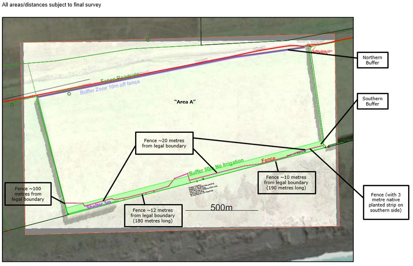
drift for ‘Area A’, as shown on Plan CRC184921A in conditions [X] are being met (see Figure 2).
1.2 Bayley Farm overview
The property was owned by Michael Bayley and his family for more than 100 years, before being
sold to Wongan Hills who took over management of the farm in April 2018.
Prior to 2018, the farm was operated as a series of large paddocks with mostly dry (not irrigated)
grassland grazing. Parts of Paddock 10 have been cultivated as fields of potatoes for many years
with irrigation using hand shift sprinklers. Other parts of the property have to varying extents
been subject to pasture improvement and maintenance activities over time.
The areas over which irrigation has been approved include the following (refer to Figure 3);
• Paddock 7 - Most of the paddock (140.5 ha out of 146 ha) that is being used for irrigated
pasture and crops. Indigenous-dominated but degraded grassland occupies a small area
along the south-western boundary and corner of the paddock (Figure 2) and is not
irrigated.
• Paddock 9 (in part) that is being used for irrigated pasture and crops. The balance of the
paddock is mainly improved pasture farmed on a dryland basis. Indigenous-dominated
grassland communities are located along the southern part of this paddock but are
located some distance from the irrigation area.
• Paddock 10 (in part) - is being used for irrigated pasture and crops. The balance of the
paddock is mainly improved pasture and is being farmed on a dryland basis. Indigenous-
dominated grassland communities are located along the southern part of this paddock
but are located some distance from the irrigation area.
Bayley Road Farm; Paddock 7 irrigation effects monitoring project 18063 Figure 1. Bayley Road Farm paddock layout, showing paddock locations and consented irrigation areas (orange shaded blocks). Bayley Road Farm; Paddock 7 irrigation effects monitoring project 1806
4

Figure 2. Paddock 7 layout of required setbacks and buffers as per consent CRCXXXXXX.

Bayley Road Farm; Paddock 7 irrigation effects monitoring                               project 1806
5

1.3           Ecological context
Kaitorete Spit is a 25 km long barrier ridge of Holocene gravels partially covered in sand dunes
that rise to about 5 m above sea level. The coastal margin is characterised by a shingle beach, and
extensive sand dune ecosystem and associated sand flats. The inland margin forms part of the
margin of Lake Ellesmere/ Te Waihora.

Kaitorete Spit has a harsh climate characterised by low precipitation, high summer temperatures,
high humidity, strong and persistent winds and salt spray. Together these have influenced the
indigenous flora and fauna found there, with many species reliant upon these characteristics,
such as low precipitation, to survive.

Most of Kaitorete Spit is classified as LENZ Level IV category J2.1b land environment1. Because
only 2.5 % of indigenous cover remains on this land environment nationally, the landform that
supports indigenous vegetation and unmodified features on the Bayley Farm is considered to be
‘acutely threatened’ (the highest priority for protection at a national level).

As a whole, Kaitorete Spit probably comprises the largest remaining area of indigenous dryland
vegetation in lowland Canterbury2. The Spit contains the largest naturally-vegetated dunelands in
New Zealand, and the largest population of pingao (Ficinia spiralis; At Risk- Declining) in the
country. The Spit also supports most of the wild population of the threatened shrub, shrubby
tororaro (Muehlenbeckia astonii; Threatened - Nationally Endangered).

The indigenous vegetation and habitats remaining on the Spit are considered to be regionally and
nationally significant for their indigenous biodiversity. Hutchison (2018) records 13 species of
plant that are classified as Threatened or At Risk from the Spit. Many of these are associated with
dry grassland or dune ecosystems and include a range of woody and non-woody species. Several
species are small and cryptic in form with strongly seasonal above-ground growth, meaning that
they can be missed if surveys are undertaken at times when plants are not visible.

Kaitorete Spit contains five naturally uncommon (historically rare) ecosystem types. Of these, the
following are represented within the Bayley Farm property, on the seaward edge of Paddocks 1-
10:

       •    Stable sand dunes and
       •    Dune deflation hollows.

Kaitorete Spit supports a range of locally endemic, Threatened and At Risk birds, lizards and
invertebrates. Most of these are associated with coastal dunelands and lake margins. The 2015
assessment of Paddock 7 by Wildland Consultants3 noted that 204 bird species have been
recorded on the lake and around the Spit. Many of these are not native to New Zealand and many
others have habitat preferences that do not include managed farmland.

1
    See https://www.landcareresearch.co.nz/resources/maps-satellites/threatened-environment-classification

3
  Wildland Consultants Ltd. 2015. Ecological assessment of the proposed rocket lab launch site on Kaitorete Spit,
Canterbury. Report prepared for Christchurch City Council.

Bayley Road Farm; Paddock 7 irrigation effects monitoring                                                      project 1806
6 Of the native birds that may use the site, NZ pipit (Anthus novaeseelandiae; At Risk – Declining) uses open areas to forage, as do banded dotterel (Charadrius bicinctus; Threatened – Nationally Vulnerable). Of the four native lizards recorded from Kaitorete Spit, two may use the grassland areas of the farm, in particular those areas where shrub clumps and tussock aggregations still exist. The southern grass skink (Oligosoma aff. polychroma Clade 5; At Risk - Declining) is likely to be present within Paddocks 1-6 where grasses are dense, and shrubs and tussocks are present. Waitaha gecko (Woodworthia cf. brunnea; At Risk - Declining) is most abundant on the Spit in dunelands and where shrub cover predominates. Within the Bayley Road Farm, Paddocks 1-6 and parts of 9 support a range of indigenous species, including shrubby tororaro, scrub pohuehue (Muehlenbeckia complexa), prostrate and common broom (Carmichaelia appressa, C. australis), porcupine shrub (Melicytus alpinus), and silver tussock (Poa cita) most visible. Hutchinson (2018) recorded 20 other indigenous plants within Paddocks 1-10, with the greatest diversity found within Paddocks 1-6. The southern coastal ends of Paddocks 1-10 have areas of hind-dune sandy soils and associated vegetation that differs from the flat, and more developed, soils of the majority of the paddock areas. Within these hind-due areas vegetation is predominantly indigenous and supports pingao, Acaena buchananii, prostrate broom and common broom, amongst indigenous and exotic grasses and weeds. Dune deflation hollows within some of these areas (in particular Paddocks 1, 9 and 10) support the indigenous plants pygmy twitch (Zoysia minima) and the ground lichen Xanthoparmelia semiviridis. There is an extensive area of Scientific Reserve land managed by the Department of Conservation that extends from the west of Birdlings Flat along the seaward side of the Spit including the foredune, dune crest and rear dune. Ecological communities are far less modified than those on the rear dunes and sand flats that comprise Bayley Farm (and other farmed areas). The reardunes and sand flats of the DOC Reserve adjoining Paddocks 1-10 on Reserve land support exotic pasture grasses in part, with locally dominant indigenous communities comprising pohuehue, C. appressa, pingao, shore bindweed, catsear and sorrel. 1.4 Consent Conditions The conditions of consent CRCXXXXXX for Paddock 7 that are relevant to this Irrigation Effects Management Plan are listed below. [ to be inserted when confirmed] 2.0 Irrigation areas 2.1 Irrigation areas and buffers The areas consented for irrigation are shown on Figure 1 and comprise parts of paddocks 7, 9 and 10. Buffers to the irrigation areas are provided for in each paddock, and in accordance with the ecological values that are in adjacent areas. Bayley Road Farm; Paddock 7 irrigation effects monitoring project 1806
7

In accordance with the consent conditions, monitoring is required in relation to the southern
boundary of the Paddock 7 irrigation area.

Paddock 7 includes:

      •   a 50 m buffer set-back adjoining the southern boundary and a 10 m set-back from the
          northern boundary within which no irrigation can occur;
      •   a fenced-off area largely within the southern buffer area. The fence is located between
          approximately 10 and 100 metres from the southern boundary as shown in Figure 2; and
      •   a strip of native planting that is 3 metres wide to the immediate south of the fence (to be
          developed in consultation with DOC on the species planted). The balance of the dryland
          area beyond the planted strip comprises either indigenous-dominated but degraded
          grassland located in the south-western corner of the paddock or pasture dominated with
          dryland exotics.

The 3 m wide buffer line of natives required to be established in Paddock 7 will be watered by
drip irrigator with the intention being that only minimal water will be used to assist with plant
establishment. Given the soil properties, contour and drip irrigation4 proposed it is considered
unlikely that localised watering such as this will result in lateral movement of water and increased
soil moisture in areas beyond the native plantings proposed to be drip irrigated.

2.2        Irrigation technology in Paddock 7
The consent conditions require that pivot irrigators are used to provide irrigation water to the
approved area are managed such that:

      •   Irrigation of the area of duneland community on DOC Reserve land along the southern
          boundary of Paddock 7 (Figure 2) is avoided. This is achieved by ensuring that the end gun
          and sprinklers of the pivot are shut off automatically when the spray boom travels over
          this area. No ground disturbance from wheels or pivot parts occurs within this area; and

      •   Irrigation technology and practices are required by the consent conditions that reduce the
          likelihood of unintended spray drift over the indigenous plant community shown in Figure
          2 and over the adjacent DOC Reserve land (to the south) that also supports duneland
          ecological values. Features include:

              o    Providing a setback of wetted area from the coastal boundary of 30 m and when
                   at 90° to the boundary the last two sprinklers will be solenoid valve-turned ‘off’ to
                   provide a greater setback ~50 m; and
              o    Using Komet Oscillator sprinklers that emit large droplets, and hence reduce the
                   likelihood of droplet drift; and
              o    Setting sprinklers at 1.6 m above ground to further minimise any drift; and

4
 Davoren, A. 14 May 2019. Review of Philip Grove comment on Applications CRC193743, CRC193745, and CRC193748,
Bayley Farm. Memorandum provided by A Davoren, Hydroservices Ltd, for Wongan Hills Ltd.

Bayley Road Farm; Paddock 7 irrigation effects monitoring                                          project 1806
8
o Having a cut-off wind speed of ~45 kmph (30-minute average), applicable only to
end gun use within a 90° arc to the south boundary of Paddock 7.
3.0 Monitoring Design
3.1 Location and rationale for monitoring plots
The intention of the monitoring programme is to detect any change in plant community form,
provenance and dominance due to irrigate effects that may occur on DOC Reserve Land adjoining
the southern boundary of Paddock 7. The monitoring programme is designed to detect changes
in communities where indigenous plants species dominate.
Monitoring plots on DOC Reserve land may still be affected by factors other than the potential
effects of irrigation from the Paddock 7 pivot irrigators. This includes the impact of predators and
pests and also climatic events. In undertaking monitoring careful regard needs to be had to
identifying effects that arise from irrigation (only).
Non-treatment (i.e. distant from irrigation effects) sites as comparative controls to the Paddock 7/
DOC Reserve monitoring plots have been included within the DOC Reserve land at the rear of
Paddocks 3-6 – these are at least 500 m distant from the Paddock 7 irrigator and are intended to
provide a baseline comparison to plots at the Paddock 7 boundary.
Areas within almost all of Paddock 7 are not suitable as monitoring sites, as vegetation within
those areas is likely to be grazed, herbicide sprayed and cultivated as part of normal farm
activities (this is also the case with areas surrounding Paddocks 9 and 10 irrigated areas).
Monitoring may be possible in the degraded indigenous-dominated grassland that occupies the
small area south-western corner of Paddock 7, but this area has until recently been extensively
grazed. Although the site has since been fenced to exclude stock, this has resulted in substantial
colonisation and growth of exotic grasses, as well as recovery of some of the indigenous
components of the community. For the next few years, it is anticipated that there will be ongoing
changes in the fenced part of the southern buffer area, and those changes may not be related at
all to the effects of irrigation overspray or soil moisture changes, should these occur.
There are no other areas of a similar vegetation composition within the Bayley Road Farm that
also have stock and other farming activities excluded and which could serve as non-treatment
controls.
Taking all of the above into consideration, the monitoring plots will be located (see Figure 3):
1. Along the southern boundary of Paddock 7;
2. On the DOC Reserve at the rear of Paddocks 3-6.
Bayley Road Farm; Paddock 7 irrigation effects monitoring project 18069 Figure 3. Proposed monitoring sites. Treatment plots within and adjoining Paddock 7, and non-treatment controls within the DoC Reserve at the rear of Paddocks 3-6. Bayley Road Farm; Paddock 7 irrigation effects monitoring project 1806
10

Locating plots5

       •    Plots will be located using a stratified random method along (for treatment plots) the DOC
            Reserve land bordering the southern boundary of Paddock 7, and the southern boundary
            of Paddocks 3-6 (non-treatment control plots; where plots will be at least 500 m from the
            Paddock 7 irrigator). A single line of lots will be installed, as the intention (consistent with
            the consent conditions that require the avoidance of effects) is to monitor the minimum
            (not the maximum) distance of potential effect of the irrigator.

Plot size and marking

       •    Plots will comprise 1 m x 1 m square plots
       •    Plots will be identified by marking corners with permanent numbered pegs in the ground.
            Plot locations will be recorded by GPS.

Number of plots

       •    Along the Paddock 7 DOC boundary                          [X]
       •    Along the Paddocks 3-6 DOC boundary                       [X]

[Final plots to be advised following final access/concession agreement with DOC]

Sampling method

In each 1 m by 1 m square plot, each vascular and non-vascular species will be identified and the
cover of each estimated to the nearest 1 %, as well as bare soil, bare rock, and litter.

Ecologically similar species (such as Rytidosperma spp.) may be grouped if individual identification
is problematic.

Anything < 1% will be given a nominal 0.5 % cover.

All transects and plots will be assessed and photographed, along with any specimens collected for
identification (where identification is not able to be determined in situ or off the photographs
taken).

3.2           Soil moisture monitoring
Soil moisture monitoring will be carried out within the 50 m buffer area. The soil moisture
monitoring will include:

       •    Nutron soil moisture probes (or an equivalent as supplied by Hydro Services or another
            company with expertise in soil moisture monitoring);

       •    two sets of tubes located at distances 0 m, 20 m, and 50 m from land that is directly
            irrigated, providing a total of 6 measured locations; and

       •    Measurements will be taken at least every 4 weeks following the commencement of
            irrigation in an irrigation season, with a further final measurement being taken at least 2

5
    Based in part on advice provided by S. Walker to Environment Canterbury, dated 28 January 2019.

Bayley Road Farm; Paddock 7 irrigation effects monitoring                                             project 1806
11
weeks and no greater than 4 weeks after the final cessation of irrigation for each
irrigation season
3.3 Humidity monitoring
Humidity monitoring will be carried out within:
• each ecological monitoring area (with a humidity monitor located in close proximity to
the two ecological monitoring plots identified in Figure 3); and
• an area to the north of Area A as shown on Figure 3.
Measurements will be taken at a minimum of 30-minute intervals and the results stored/logged
electronically.
3.4 Timing and frequency
Plots will be monitored during in period between 1 December and 31 January in order to coincide
with the maximum seeding period for Rytidosperma spp. grasses – for which identification is likely
to require most effort.
Frequency of monitoring is set by Condition [x], which requires that monitoring be undertaken at
a minimum of:
• once in the period 1 December 2019 to 31 January 2020; and
• once in the period 1 December 2020 to 31 January 2021; and
• once in the period 1 December 2021 to 31 January 2022; and
• once in the period 1 December 2024 to 31 January 2025; and
• once in the period 1 December 2029 to 31 January 2030.
4.0 Reporting and review
Wongan Hills will, by 30 June in each year that monitoring surveys are undertaken, provide a
report that sets out the results of the monitoring surveys undertaken in accordance with
condition [X] and which is prepared by the appropriately qualified person, to the Canterbury
Regional Council Attention Regional Leader - Monitoring and Compliance.
The report shall:
• identify any changes in species composition, growth or form that in the opinion of the
appropriately qualified expert are as a result of irrigation in ‘Area A’, as shown on Plan
CRCXXXXXXX (Figure 2); and
• identify any increases in soil moisture as measured with the Nutron soil moisture probes
and humidity that are not associated with a rainfall event.
Bayley Road Farm; Paddock 7 irrigation effects monitoring project 1806You can also read