Belmayne P4, Belmayne, Dublin 13 - Landscape and Visual Impact Appraisal Prepared for - Belmayne SHD
←
→
Page content transcription
If your browser does not render page correctly, please read the page content below
CUNNANE STRATTON REYNOLDS

                                                       Belmayne P4,
                                                          Belmayne,
                                                           Dublin 13

                            Landscape and Visual Impact Appraisal

                                                        Prepared for
                                            Balgriffin Park Limited

                                                              by
                                       Cunnane Stratton Reynolds

                                                           April 2021

                                              3 Molesworth Place, Dublin 2
                                                          Tel: 01 661 0419

                                                         Fax: 01 661 0431
                                                Email: info@csrlandplan.ie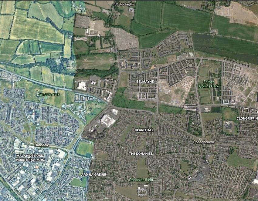
Table of Contents
1 INTRODUCTION ............................................................................................................................. 2
2 METHODOLOGY............................................................................................................................. 2
2.1 Forces for Landscape Change ................................................................................................ 2
2.2 Guidance ................................................................................................................................. 3
2.3 Assessment of Both ‘Landscape’ and ‘Visual’ Effects............................................................. 3
2.4 Methodology for Landscape Appraisal.................................................................................... 4
2.5 Methodology for Visual Appraisal............................................................................................ 6
2.6 Quality and Timescale of Effects............................................................................................. 7
3.1. Characteristics of the Proposed Development........................................................................ 9
4 RECEIVING ENVIRONMENT ....................................................................................................... 10
4.1 Relevant Planning Policy ...................................................................................................... 10
4.1.1 Dublin City Development Plan 2016-2022 (DCDP/Development Plan) ........................ 10
4.1.2 Clongriffin-Belmayne Local Area Plan 2012-2018 (extended to December 2022) ....... 14
4.1.3 Draft Belmayne & Belcamp Lane Masterplan July 2020............................................... 16
4.1.4 Fingal County Council Development Plan 2017-202 (FCCDP) .................................... 18
4.1.5 Landscape Character Assessment ............................................................................... 19
4.1.7 Summary of Planning Policy and Objectives ................................................................ 21
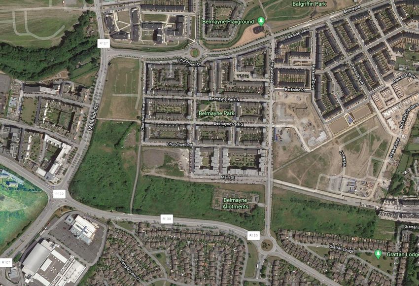
4.2 Description of Receiving Environment .................................................................................. 22
4.3 Summary of Landscape Characteristics and Values ............................................................ 26
5 POTENTIAL IMPACTS OF THE DEVELOPMENT ....................................................................... 27
5.1 Construction Stage ................................................................................................................ 27
5.2 Operational Stage ................................................................................................................. 27
5.3 Potential Cumulative Impacts................................................................................................ 28
5.4 Do-Nothing Approach ............................................................................................................ 28
5.5 Remedial or Reduction Measures: Mitigation ....................................................................... 28
5.5.1 Construction Phase ....................................................................................................... 28
5.5.2 Operational Phase......................................................................................................... 28
5.5.3 ‘Worst-case’ Scenario ................................................................................................... 29
6 PREDICTED LANDSCAPE IMPACTS .......................................................................................... 30
6.1 Landscape Sensitivity ........................................................................................................... 30
6.2 Predicted Landscape Impacts and Effects............................................................................ 30
7 PREDICTED VISUAL IMPACT ...................................................................................................... 32
7.1 Zone of Visual Influence and Potential Visual Receptors ..................................................... 32
7.2 Description of Viewpoints ...................................................................................................... 33
7.3 Summary of Visual Effects .................................................................................................... 42
8 CONCLUSION ............................................................................................................................... 43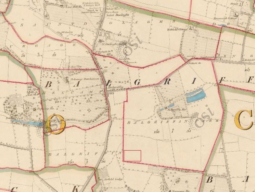
1        INTRODUCTION

This document has been prepared by Cunnane Stratton Reynolds Ltd (CSR), landscape architects and
planners.

The Landscape and Visual Impact Appraisal (LVIA) was informed by a desktop study and a survey of
the site and receiving environment in July 2020. This report identifies and discusses the townscape and
the receiving environment in relation to proposed development at the Belmayne, Dublin 13.

The subject site is approximately 1.31ha and is located on the southwestern corner of the Belmayne
housing estate directly south of Churchwell Road and west of Churchwell Crescent, Belmayne, Balgriffin
Dublin 13. The site formed the P4 part of the original Belmayne development which had previously been
granted planning permission in 2002 under Reg Ref. 0354/02 and as amended, now lapsed, for an
apartment block of up to six storeys over basement. However, the lands currently remain undeveloped
and are contained by fencing along the boundary.

2        METHODOLOGY

Ireland is a signatory to the European Landscape Convention (ELC). The ELC defines landscape as ‘an
area, as perceived by people, whose character is the result of the action and interaction of natural and/or
human factors’. This definition is important in that it expands beyond the idea that landscape is only a
matter of aesthetics and visual amenity. It encourages a focus on landscape as a resource in its own
right - a shared resource providing a complex range of cultural, environmental and economic benefits
to individuals and society.

As a cultural resource, the landscape functions as the setting for our day-to-day lives, also providing
opportunities for recreation and aesthetic enjoyment and inspiration. It contributes to the sense of place
experienced by individuals and communities and provides a link to the past as a record of historic socio-
economic and environmental conditions. As an environmental resource, the landscape provides habitat
for fauna and flora. It receives, stores, conveys and cleans water, and vegetation in the landscape stores
carbon and produces oxygen. As an economic resource, the landscape provides the raw materials and
space for the production of food, materials (e.g. timber, aggregates) and energy (e.g. carbon-based
fuels, wind, solar), living space and for recreation and tourism activities.

2.1      Forces for Landscape Change

The GLVIA notes that the landscape is change is ongoing. Many different pressures have progressively
altered familiar landscapes over time and will continue to do so in the future, creating new landscapes.
For example, within the receiving environment, the environs of the proposed development have altered
over the last thousand years, from wilderness to agriculture and settlement.

Many of the drivers for change arise from the requirement for development to meet the needs of a
growing population and economy. The concept of sustainable development recognises that change
must and will occur to meet the needs of the present, but that it should not compromise the ability of
future generations to meet their needs. This involves finding an appropriate balance between economic,
social and environmental forces and values.

The reversibility of change is an important consideration. If change must occur to meet a current need,
can it be reversed to return the resource (in this case, the landscape) to its previous state to allow for
development or management for future needs.

Climate change is one of the major factors likely to bring about future change in the landscape, and it is
accepted to be the most serious long-term threat to the natural environment, as well as economic activity
(particularly primary production) and society. The need for climate change mitigation and adaptation,
which includes the management of water and more extreme weather and rainfall patterns, is part of this.

Belmayne P4, Belmayne, Dublin 13 - Landscape and Visual Impact Appraisal                                 2
2.2       Guidance
Landscape and Visual Appraisal is a tool used to identify the effects of change resulting from
development on both the landscape as an environmental resource in its own right and on people’s views
and visual amenity. As this report is not part of an Environmental Impact Assessment Report (EIAR),
and is instead a standalone Landscape and Visual Appraisal, the report does not include a statement
of the significance of effects. However the process by which the landscape and visual effects are
identified is similar to that of a Landscape and Visual Assessment carried out as part of an EIAR.

The methodology is informed by the following key guidance documents, namely:

      •   Guidelines for Landscape and Visual Impact Assessment, 3rd Edition 2013, published by the
          UK Landscape Institute and the Institute of Environmental Management and Assessment
          (hereafter referred to as the GLVIA).
      •   Guidelines on the information to be contained in Environmental Impact Assessment Reports
          (Draft August 2017, EPA).

References are also made to the ‘Landscape and Landscape Assessment – Consultation Draft of
Guidelines for Planning Authorities’ document, published in 2000 by the Department of Environment,
Heritage and Local Government.

Use of the Term ‘Effect’ vs ‘Impact’

The GLVIA advises that the terms ‘impact’ and effect’ should be clearly distinguished and consistently
used in the preparation of an LVIA.

 ‘Impact’ is defined as the action being taken. In the case of the proposed works, the impact would
include the construction of the proposed development.

 ‘Effect’ is defined as the change or changes resulting from those actions, e.g. a change in landscape
character, or changes to the composition, character and quality of views in the receiving environment.
This report focusses on these effects.

2.3 Assessment of Both ‘Landscape’ and ‘Visual’ Effects
Another key distinction to make in a LVIA is that between landscape effects and the visual effects of
development.

 ‘Landscape’ results from the interplay between the physical, natural and cultural components of our
surroundings. Different combinations of these elements and their spatial distribution create distinctive
character of landscape in different places. ‘Landscape character assessment’ is the method used in
LVIA to describe landscape, and by which to understand the potential effects of a development on the
landscape as ‘a resource’. Character is not just about the physical elements and features that make up
a landscape, but also embraces the aesthetic, perceptual and experiential aspects of landscape that
make a place distinctive.

Views and ‘visual amenity’ refer to the interrelationship between people and the landscape. The GLVIA
prescribes that effects on views and visual amenity should be assessed separately from landscape,
although the two topics are inherently linked. Visual assessment is concerned with changes that arise
in the composition of available views, the response of people to these changes and the overall effects
on the area’s visual amenity.

The appraisal of landscape and visual effects included a desktop study, review of the proposed
development drawings and visualisations, and a site visit which was carried out in July 2020.

Belmayne P4, Belmayne, Dublin 13 - Landscape and Visual Impact Appraisal                              3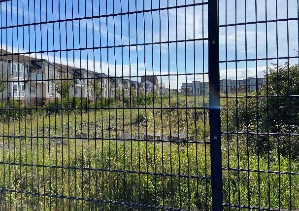
2.4      Methodology for Landscape Appraisal
Landscape appraisal considers the sensitivity of the receptor, and the likely nature and magnitude of
the changes to the main landscape elements and characteristics. Existing trends of change in the
landscape are taken into account.

Sensitivity of the Landscape Resource

Landscape Sensitivity: Landscape sensitivity is a function of its land use, landscape patterns and
scale, visual enclosure and distribution of visual receptors, scope for mitigation, and the value placed
on the landscape. It also relates to the nature and scale of development proposed. It includes
consideration of landscape values as well as the susceptibility of the landscape to change.

 Landscape values can be identified by the presence of landscape designations or policies which
indicate particular values, either on a national or local level. In addition, a number of criteria are used to
assess the value of a landscape. These are described further in Section 1.6 below.

Landscape susceptibility is defined in the GLVIA as the ability of the landscape receptor to
accommodate the proposed development without undue consequences for the maintenance of the
baseline scenario and/or the achievement of landscape planning policies and strategies. Susceptibility
also relates to the type of development – a landscape may be highly susceptible to certain types of
development but have a low susceptibility to other types of development.

For the purpose of assessment, three categories are used to classify the landscape sensitivity of the
receiving environment.

Sensitivity is therefore a combination of Landscape value and Susceptibility.

 Sensitivity        Description

 High               Areas where the landscape exhibits strong, positive character with valued elements,
                    features and characteristics. The character of the landscape is such that it has
                    limited/low capacity for accommodating change in the form of development. These
                    attributes are recognised in landscape policy or designations as being of national,
                    regional or county value and the principal management objective for the area is
                    conservation of the existing character.

 Medium             Areas where the landscape has certain valued elements, features or characteristics
                    but where the character is mixed or not particularly strong. The character of the
                    landscape is such that there is some capacity for change in the form of development.
                    These areas may be recognised in landscape policy at local or county level and the
                    principal management objective may be to consolidate landscape character or
                    facilitate appropriate, necessary change.

 Low                Areas where the landscape has few valued elements, features or characteristics and
                    the character is weak. The character of the landscape is such that it has capacity for
                    change; where development would result in a minor change or would make a
                    positive change. Such landscapes are generally unrecognised in policy and where
                    the principal management objective is to facilitate change through development,
                    repair, restoration or enhancement.

Table 1 – Categories of Landscape Sensitivity

Magnitude of Landscape Change: The magnitude of change is a factor of the scale, extent and degree
of change imposed on the landscape with reference to its key elements, features and characteristics
(also known as ‘landscape receptors’). Four categories are used to classify magnitude of landscape
change.

Belmayne P4, Belmayne, Dublin 13 - Landscape and Visual Impact Appraisal                                     4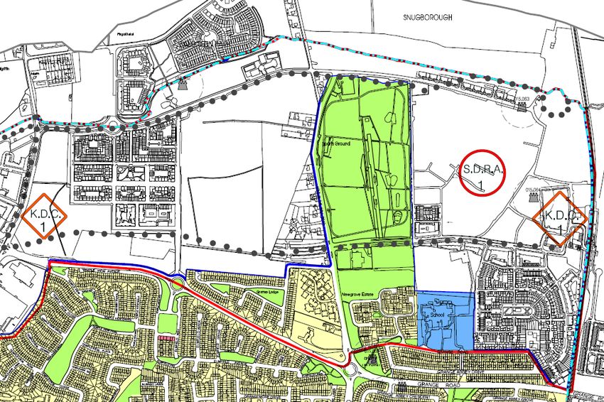
Magnitude                 of     Description
 Change

 High                              Change that is moderate to large in extent, resulting in major alteration to key
                                   elements, features or characteristics of the landscape and/or introduction of large
                                   elements considered uncharacteristic in the context. Such development results
                                   in change to the character of the landscape.

 Medium                            Change that is moderate in extent, resulting in partial loss or alteration to key
                                   elements, features or characteristics of the landscape, and/or introduction of
                                   elements that may be prominent but not necessarily substantially
                                   uncharacteristic in the context. Such development results in change to the
                                   character of the landscape.

 Low                               Change that is moderate or limited in scale, resulting in minor alteration to key
                                   elements, features or characteristics of the landscape, and/or introduction of
                                   elements that are not uncharacteristic in the context. Such development results
                                   in minor change to the character of the landscape.

 Negligible                       Change that is limited in scale, resulting in no alteration to key elements, features
                                  or characteristics of the landscape key elements features or characteristics of the
                                  landscape, and/or introduction of elements that are characteristic of the context.
                                  Such development results in no change to the landscape character.

Table 2 – Categories of Landscape Change

Landscape Effects

A conclusion on the relative importance of landscape effects (either on physical landscape elements or
on the landscape character) can be arrived at by combining the landscape sensitivity and the magnitude
of change. This is illustrated in Figure 1 below.

As this report is not part of an Environmental Impact Assessment Report (EIAR), and is instead a
standalone Landscape and Visual Appraisal, the report does not include a statement of the significance
of effects.

                                       Sensitivity
                                                                     Importance of Effect
                                       High          Low

                                High                                       High

                                Med                                         Moderate

                                Low                                         Low
               Magnitude

                                Neg*

* Negligible
Figure 1: Guide to the classification of the level of effects

Belmayne P4, Belmayne, Dublin 13 - Landscape and Visual Impact Appraisal                                                  5
Landscape effects are also classified as positive, neutral or negative/adverse. Development has the
potential to improve the environment as well as damage it. In certain situations, there might be policy
encouraging a type of change in the landscape, and if a development achieves the objective of the
policy the resulting effect might be positive, even if the landscape character is profoundly changed.

2.5       Methodology for Visual Appraisal
Visual appraisal considers the changes to the composition of views, the character of the views, and the
visual amenity experienced by visual receptors. Visual receptor sensitivity is a function of two main
considerations:

      •   Susceptibility of the visual receptor to change. This depends on the occupation or activity of the
          people experiencing the view, and the extent to which their attention or interest is focussed on
          the views or visual amenity they experience at that location.

Visual receptors most susceptible to change include residents at home, people engaged in outdoor
recreation focused on the landscape (e.g. trail users), and visitors to heritage or other attractions and
places of community congregation where the setting contributes to the experience.

Visual receptors less susceptible to change include travellers on road, rail and other transport routes
(unless on recognised scenic routes which would be more susceptible ), people engaged in outdoor
recreation or sports where the surrounding landscape does not influence the experience, and people in
their place of work or shopping where the setting does not influence their experience.

      • Value attached to the view. This depends to a large extent on the subjective opinion of the visual
        receptor but also on factors such as policy and designations (e.g. scenic routes, protected
        views), or the view or setting being associated with a heritage asset, visitor attraction or having
        some other cultural status (e.g. by appearing in arts).

Three categories are used to classify a viewpoint’s sensitivity:

 Sensitivity        Description

 High               Viewers at viewpoints that are recognised in policy or otherwise designated as being
                    of value, or viewpoints that are highly valued by people that experience them
                    regularly (such as views from houses or outdoor recreation features) and views
                    which are valued by the local community. This would include tourist attractions, and
                    heritage features of regional or county value, and viewers travelling on scenic
                    routes.

 Medium             Viewers at viewpoints representing people travelling at slow or moderate speed
                    through or past the affected landscape in cars or on public transport, where they are
                    partly but not entirely focused on the landscape, or where the landscape has some
                    valued views. The views are generally not designated, but which include panoramic
                    views or views judged to be of some scenic quality, which demonstrate some sense
                    of naturalness, tranquillity or some rare element in the view.

 Low                Viewers at viewpoints reflecting people involved in activities not focused on the
                    landscape e.g. people at their place of work or engaged in similar activities such as
                    shopping, etc. The view may present an attractive backdrop to these activities but
                    there is no evidence of that the view is valued, and not regarded as an important
                    element of these activities. Viewers travelling at high speeds (e.g. motorways) may
                    also be considered of low susceptibility.

Table 3 – Categories of Visual Receptor Sensitivity

Belmayne P4, Belmayne, Dublin 13 - Landscape and Visual Impact Appraisal                                    6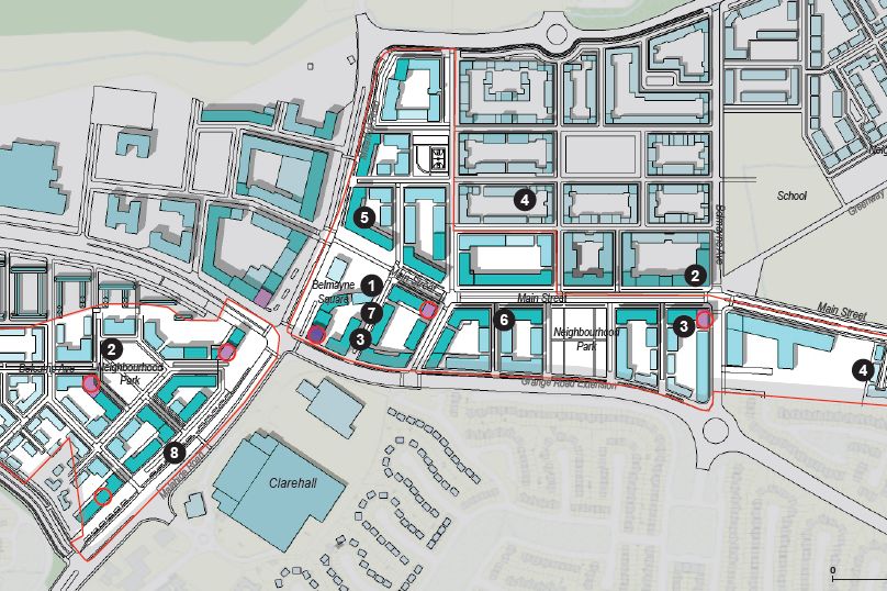
Magnitude of Change to the View
Classification of the magnitude of change takes into account the size or scale of the intrusion of
development into the view (relative to the other elements and features in the composition, i.e. its relative
visual dominance), the degree to which it contrasts or integrates with the other elements and the general
character of the view, and the way in which the change will be experienced (e.g. in full view, partial or
peripheral, or glimpses). It also considers the geographical extent of the change, the duration and the
reversibility of the visual effects.

Four categories are used to classify magnitude of change to a view.

 Magnitude        of   Description
 Change

 High                  Extensive intrusion of the development in the view, or partial intrusion that
                       obstructs valued features, or introduction of elements that may be considered
                       uncharacteristic in the context, to the extent that the development becomes co-
                       dominant with other elements in the composition and affects the character of the
                       view and the visual amenity.

 Medium                Partial intrusion of the development in the view, or introduction of elements that
                       may be prominent but not necessarily uncharacteristic in the context, resulting in
                       change to the composition but not necessarily the character of the view or the
                       visual amenity.

 Low                   Minor intrusion of the development into the view, or introduction of elements that
                       are not uncharacteristic in the context, resulting in minor alteration to the
                       composition and character of the view but no change to visual amenity.

 Negligible            Barely discernible intrusion of the development into the view, or introduction of
                       elements that are characteristic in the context, resulting in slight change to the
                       composition of the view and no change in visual amenity.

Table 4 – Magnitude of Visual Change

Visual Effects

A conclusion on the relative importance of visual effects can be arrived at by combining the visual
receptor sensitivity and the magnitude of change. This is included in Figure 1 above as for Landscape
Effects.

As this report is not part of an Environmental Impact Assessment Report, and is instead a standalone
Landscape and Visual Appraisal, the report does not include a statement of the significance of effects.

Visual effects are also classified as positive, neutral or negative/adverse as set out below:

2.6      Quality and Timescale of Effects

The predicted effects are also classified as beneficial, neutral or adverse. This is not an absolute
exercise; in particular, visual receptors’ attitudes to development, and thus their response to the impact
of a development, will vary. However, the methodology applied is designed to provide robust justification
for the conclusions drawn. These qualitative impacts/effects are defined as:

         •    Adverse – Scheme at variance with landform, scale, pattern. Would degrade, diminish or
              destroy the integrity of valued features, elements or their setting or cause the quality of the
              landscape(townscape)/view to be diminished;

         •    Neutral - Scheme complements the scale, landform                     and    pattern   of   the
              landscape(townscape)/view and maintains landscape quality;

Belmayne P4, Belmayne, Dublin 13 - Landscape and Visual Impact Appraisal                                    7
•    Beneficial – improves landscape(townscape)/view quality and character, fits with the scale,
              landform and pattern and enables the restoration of valued characteristic features or
              repairs / removes damage caused by existing land uses.

Effects are also categorised according to their longevity or timescale:

         •    Temporary – Lasting for one year or less;

         •    Short Term – Lasting one to seven years;

         •    Medium Term – Lasting seven to fifteen years;

         •    Long Term – Lasting fifteen years to sixty years;

         •    Permanent – Lasting over sixty years.

Belmayne P4, Belmayne, Dublin 13 - Landscape and Visual Impact Appraisal                               8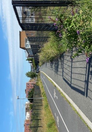
3          CHARACTERISTICS OF THE DEVELOPMENT

3.1.       Characteristics of the Proposed Development

The proposed development will involve:

       •   the clearance of the existing mounds, vegetation cover and security fencing within the extent of
           the site at Belmayne, Dublin 13.
       •   the construction of a 2 to 7 storey residential accommodation consisting of the following uses:
           (a) 260 no. apartments, comprising of 108 no. one-bed apartments 135 no. two-bed
               apartments and 17 no. three-bed apartment units;
           (b) 199 no. car parking spaces (188 undercroft and 19 on street) and 400 no. cycle space.
           (c) Two internal communal courtyards (above the undercroft parking area)

The development features landscaping and all associated site development works.

From a landscape and visual impact perspective the key issue is the height of the proposed
development and its interaction with surrounding areas.

Belmayne P4, Belmayne, Dublin 13 - Landscape and Visual Impact Appraisal                                 9
4 RECEIVING ENVIRONMENT
This section is divided into a review of landscape related Planning Policy as set out in the Dublin City
Development Plan 2016-2022 and Fingal County Council Development Plan 2017-2023 and associated
documents, and a description of the study areas informed by desktop assessment.
4.1 Relevant Planning Policy
The Dublin City Development Plan 2016-2022 is reviewed in this section, in terms of relevance to the
site location and the proposed development. Due to the proximity to Fingal County Council boundary,
the Fingal County Council Development Plan 2017-2023 is also touched upon.
4.1.1 Dublin City Development Plan 2016-2022 (DCDP/Development Plan)
Zoning
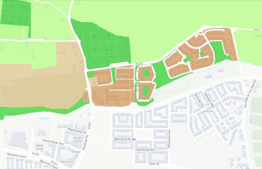
The application lands are zoned ‘Zone Z14 – Strategic Development and Regeneration Areas (SDRAs),
with the objective; “To seek the social, economic and physical development and/or rejuvenation of an
area with mixed use, of which residential and ‘Z6’ would be the predominant uses.”
Figure 2: Extract of DCDP Zoning Map C.
Site
SDRAs are areas which provide for large scale public housing within the inner city and outer city areas.
They most also include proposals for additional physical and social infrastructure/facilities to support
the housing. The site falls within SDRA 1. North Fringe (including Clongriffin/Belmayne). The key
development principles for this SDRA are outlined in a local area plan which is based on the following
objectives:
1. To create a highly sustainable, mixed use urban district, based around high quality public transport
nodes, with a strong sense of place.
2. To achieve a sufficient density of development to sustain efficient public transport networks and a
viable mix of uses and community facilities.
Belmayne P4, Belmayne, Dublin 13 - Landscape and Visual Impact Appraisal 103. To establish a coherent urban structure, based on urban design principles, as a focus for a new community and its integration with the established community, comprising the following elements: Sustainable Residential Development The DCDP suggests that all new developments to contribute to the unique identities and sense of place of neighbourhoods. Relevant Policies; QH5: To promote residential development addressing any shortfall in housing provision through active land management and a coordinated planned approach to developing appropriately zoned lands at key locations including regeneration areas, vacant sites and under-utilised sites. QH6: To encourage and foster the creation of attractive mixed-use sustainable neighbourhoods which contain a variety of housing types and tenures with supporting community facilities, public realm and residential amenities, and which are socially mixed in order to achieve a socially inclusive city. QH8: To promote the sustainable development of vacant or under-utilised infill sites and to favourably consider higher density proposals which respect the design of the surrounding development and the character of the area. QH18: To promote the provision of high quality apartments within sustainable neighbourhoods by achieving suitable levels of amenity within individual apartments, and within each apartment development, and ensuring that suitable social infrastructure and other support facilities are available in the neighbourhood, in accordance with the standards for residential accommodation. QH20: To ensure apartment developments on City Council sites are models of international best practice and deliver the highest quality energy efficient apartments with all the necessary infrastructure where a need is identified, to include community hubs, sports and recreational green open spaces and public parks and suitable shops contributing to the creation of attractive, sustainable, mixed-use and mixed-income neighbourhoods. SN4: To have regard to the Department of Housing, Planning, Community and Local Government’s Guidelines on Sustainable Residential Development in Urban Areas and its accompanying Urban Design Manual, 2010, the Guidelines on Local Area Plans and the related Manual, 2013 and the joint DTTS and DCLG’s Design Manual for Urban Streets and Roads (DMURS), 2013 and the NTA’s Permeability Best Practice Guide, 2015, in the making of sustainable neighbourhoods. (www.environ.ie) Urban Density SC13: To promote sustainable densities, particularly in public transport corridors, which will enhance the urban form and spatial structure of the city, which are appropriate to their context, and which are supported by a full range of community infrastructure such as schools, shops and recreational areas, having regard to the safeguarding criteria set out in Chapter 16 (development standards), including the criteria and standards for good neighbourhoods, quality urban design and excellence in architecture. These sustainable densities will include due consideration for the protection of surrounding residents, households and communities. SC14: To promote a variety of housing and apartment types which will create a distinctive sense of place in particular areas and neighbourhoods, including coherent streets and open spaces. SC15: To recognise and promote green infrastructure and landscape as an integral part of the form and structure of the city, including streets and public spaces. Belmayne P4, Belmayne, Dublin 13 - Landscape and Visual Impact Appraisal 11
Green Infrastructure, Open Space and SuDs

GI13: To ensure that in new residential developments, public open space is provided which is sufficient
in quantity and distribution to meet the requirements of the projected population, including play facilities
for children.

GI14: To promote the development of soft landscaping in public open spaces, where feasible, in
accordance with the principles of Sustainable Urban Drainage Systems.
GI7: To continue to protect and enhance landscape, including existing green spaces through
sustainable planning and design for both existing community and for future generations in accordance
with the principles of the European Landscape Convention.
GI8: To protect and enhance views and prospects which contribute to the appreciation of landscape
and natural heritage
SI18: To require the use of Sustainable Urban Drainage Systems in all new developments, where
appropriate, as set out in the Greater Dublin Regional Code of Practice for Drainage Works. The
following measures will apply:

    •    The infiltration into the ground through the development of porous pavement such as permeable
         paving, swales, and detention basins
    •    The holding of water in storage areas through the construction of green roofs, rainwater
         harvesting, detention basins, ponds, and wetlands
    •    The slow-down of the movement of water.
Community Infrastructure

GI33: To seek the provision of children’s play facilities in new residential developments. To provide
playgrounds to an appropriate standard of amenity, safety, and accessibility and to create safe and
accessible places for socialising and informal play.

Heritage and Architectural Heritage
The application lands does not fall within any protected landscapes – Architectural Conservation Areas,
Conservation Areas, Zones of Archaeological Importance and including other natural protected areas.

There are no Protected Structures on the application lands or in the immediate vicinity of the site.

Trees

GI28: To support the implementation of the Dublin City Tree Strategy, which provides the vision for the
long-term planting, protection and maintenance of trees, hedgerows and woodlands within Dublin City.
GI29: To adopt a pro-active and systematic good practice approach to tree management with the aim
of promoting good tree health, condition, diversity, public amenity and a balanced age-profile. GI30: To
encourage and promote tree planting in the planning and development of urban spaces, streets, roads
and infrastructure projects.

GI30: To encourage and promote tree planting in the planning and development of urban spaces,
streets, roads and infrastructure projects.
Development Management Standards: Large-Scale Development:
Chapter 16 outlines development management standards, and includes standards relating to large
scale development and building height and landscaping:

Dublin City Council will seek:

    •    To create new compositions and points of interest
    •    To provide high-quality new streets, squares and open spaces, where appropriate, linked to the
         surrounding street pattern, to maximise accessibility

Belmayne P4, Belmayne, Dublin 13 - Landscape and Visual Impact Appraisal                                 12
• To provide an appropriate mix of uses comprising retail, residential, entertainment, recreational,
cultural, community- and/or employment generating uses; particular emphasis should be given
to new and complementary uses and facilities that expand and improve the existing range of
uses and facilities in the area
• To carefully integrate appropriate planting and trees
• To take into account existing and likely future patterns of traffic and pedestrian movement,
including pedestrian desire lines
• To retain existing and create new features to make an easily understandable urban
environment, including active building frontages with clearly defined edges and safe public
routes
Development Management Standards: Landscaping
Standards relating to hard and soft landscaping are also referred to. In terms of hard landscaping, the
Plan notes the importance of the definition of public and private spaces, contributing to character of
areas, and defining visual links and enclosure. The plan includes advice on materials, surface water
management, boundary treatment and street furniture, with the preference for soft landscaping where
possible.
Development Management Standards : Building Height
The site of the proposed development is located within the Clogrtiffin/Belmayne North Fringe which in
an area categorised as up to ‘Mid Rise’ - as set out in Figure 19 of the Development Plan, where
buildings may be a maximum of 50 metres in height. Proposals for high building heights are further
defined within the LAP/SDZ/SDRA.
The Plan also sets out the following Assessment Criteria for Higher Buildings:
• Relationship to context, including topography, built form, and skyline having regard to the need
to protect important views, landmarks, prospects and vistas
• Effect on the historic environment at a city-wide and local level
• Relationship to transport infrastructure, particularly public transport provision
• Architectural excellence of a building which is of slender proportions, whereby a slenderness
ratio of 3:1 or more should be aimed for
• Contribution to public spaces and facilities, including the mix of uses
• Effect on the local environment, including micro-climate and general amenity considerations
• Contribution to permeability and legibility of the site and wider area
• Sufficient accompanying material to enable a proper assessment, including urban design
study/masterplan, a 360 degree view analysis, shadow impact assessment, wind impact
analysis, details of signage, branding and lighting, and relative height studies
• Adoption of best practice guidance related to the sustainable design and construction of tall
buildings
• Evaluation of providing a similar level of density in an alternative urban form.
Belmayne P4, Belmayne, Dublin 13 - Landscape and Visual Impact Appraisal 134.1.2 Clongriffin-Belmayne Local Area Plan 2012-2018 (extended to December 2022)
Local Area Plan
Local Area Plans (LAPs) set out the objectives for a specific area of Dublin City while being consistent
with the provisions of the Dublin City Development Plan. The site is located within the Clongriffin-
Belmayne (North Fringe) LAP. Occupying an area of unbuilt land already zoned for apartment buildings
on the southwest corner of the Belmayne Residential area and partially within a Key District Land (KDC).
Figure 3: Extract of DCC Clongriffin-Belmayne Local Area Plan Figure 16.4 Long Term Strategy: Phasing
Priorities Map
SITE
Urban Design Objectives
UDO1: To achieve high quality and sustainable densities to consolidate the area, maximise access for
residents and employees to public transport and successfully define important locations and routes
including the Main Street access and town centres (KDC designated zones).
UDO2: To promote the development of family orientated, high quality, adaptable, life long homes within
the LAP area through creative design that still delivers a sustainable density to support the provision of
services.
UDO3: To promote public spaces that provide both passive and active recreation and a connection to
those forms of activities in the surrounding area.
UDO4: To ensure high quality streetscapes are achieved through distinctive high quality street furniture,
lighting, paving and public artwork that creates a distinctive character associated with the North Fringe.
UDO5: To design park spaces and all open spaces linkages to be part of the larger green network in
particular from Father Collins Park to the surrounding area and along the River Mayne incorporating a
dedicated network of cycle paths and pedestrian routes.
UDO6: To achieve creative and unique character through public realm enhancements in all key
development sites through development contribution levies and partnership with the divisions of Dublin
City Council.
Belmayne P4, Belmayne, Dublin 13 - Landscape and Visual Impact Appraisal 14UDO7: The height strategy for the LAP will seek positive integration of new building height with established character. Locations identified for special height character are the designated Key District Centres (in general 5 storeys minimum) and the Main Street Boulevard axis (in general four to five storeys). Heights of 2-6 storeys (including a set back at the top floor of a 5/6 storey building) may be facilitated subject to quality design criteria and set back requirements along the river corridor to complete the urban form of pavilion buildings to complete Marrsfield, One location for a landmark profiled building (10-14 storey office height equivalent) is designated adjacent to Clongriffin Rail Station. In other locations, where 4 storeys residential height is proposed, some flexibility will be allowed on the height equivalent (13m) to achieve design improvements to the façade. Sustainability Strategy Policy & Objectives SSP1: To support sustainable design and sustainable formats of development in the LAP area which will help Dublin City Council achieve its targets in reducing energy consumption and reducing carbon dioxide emissions in accordance with the Dublin City EnergyAction Plan. SSP2: To implement the principles of the Framework for Sustainable Dublin as set out under the Dublin City Development Plan 2011-2017 at the local level and incorporate sustainable principles across all strategies for future development (both short term and long term) as identified in the LAP. Objectives: SSO1: To seek best practice in sustainable design and incorporation of green technology for all future development proposals in the LAP area across the levels of the individual buildings, the overall scheme and overall neighbourhood. SSO2: To encourage the development of exemplary projects within the LAP area that demonstrate best practice in energy efficiency (both residential and commercial) and sustainable design. SSO3: To prioritise actions under the LAP through an effective phasing programme that help to complete the development of sustainable walkable neighbourhoods with particular emphasis on, promotion of public transport, promotion of sustainable movement, promotion of consolidating areas of development with sustainable densities and enhancement of the environment and open space. SSO4: To facilitate the provision of employment uses in close proximity to residential areas to increase the opportunity for working close to the home (and thereby reducing the extent of work related commuter journeys). SSO5: To ensure that the phasing, implementation and monitoring strategy of the LAP will contribute to indicator projects for Dublin City including the Sustainability Indicators Framework that measures progress and assists policy making towards improving the quality of the environment and creating a highly sustainable city. Economic Policy ESO1: To improve the physical and visual environment of the LAP area, in particular where vacant sites exist, to provide positive first impressions that market the area for business investment. Environment and Open Space Amenity Strategy Policy & Objectives EOSP1: To realise the potential of a high quality environment as a key driver in economic development, community development, bio diversity enhancement, improved sustainable movement and enhanced quality of life for the local area. Objectives: EOSO1: To achieve best practice and innovations in SuDS design as part of development schemes including the successful co-ordination of surface water management with ecology and amenity functions of open space and landscaped areas. Belmayne P4, Belmayne, Dublin 13 - Landscape and Visual Impact Appraisal 15
Community & Social Infrastructure Policy & Objectives

CSO6: To seek to create safe and useable open spaces with each residential development for play
through overlooking and passive surveillance.

4.1.3    Draft Belmayne & Belcamp Lane Masterplan July 2020
The Draft Belmayne & Belcamp Lane Masterplan builds upon the development framework, policies and
objectives of the Clongriffin – Belmayne LAP with a detailed approach on how to develop the
undeveloped lands within Belmayne and Belcamp, including the site and new town centre.

Access and Movement
A key strategy of the draft master plan is to improve connectivity throughout the existing and proposed
residential areas, new town centre and wider area. Measures include improving existing vehicular,
cycling and pedestrian routes like Main Street and Clare Hall Greenway both near the site and various
other new routes, as shown on Figure B3.1 Access and Movement of the Masterplan.
Built Form and Heights
The masterplan illustrates the massing and proposed heights of buildings across the masterplan area
within Figure B5.1 Built Form and Height and Figure B5.2 3D overview of the Masterplan Area. The
proposed heights of buildings within the site are for 5-6 storey buildings facing onto Main Street and 2-
4 storeys to the north and northeast by Churchwell Avenue and Churchwell Crescent. The guidance
notes:
Variations will be considered to add further variety, subject to assessment criteria contained within
Urban Development and Heights, Guidelines for Planning Authorities.

2. Reinforcing Belmayne Main Street and Belcamp Avenue.
The prevailing building height is also higher along Belmayne Main Street, reinforcing it’s role as an
urban boulevard and its importance as a movement corridor, as well as ensuring a strong sense of
enclosure. A similar distribution of height is applied to Belcamp Avenue. However where the focus is on
providing houses that are lower in scale, a more strategic application is applied to positioning of higher
buildings (i.e at gateway locations).

4. Height Transitions
Buildings heights follow the patterns of surrounding neighbourhoods, where appropriate, so as to
provide a transition from established areas to those taller buildings located in the Town Centre and
along the Central Movement Corridor.

Belmayne P4, Belmayne, Dublin 13 - Landscape and Visual Impact Appraisal                               16
Figure 4: Extract of DCC Draft Belmayne & Belcamp Lane Masterplan Figure B5.1 Built Form and Height
Map

                                                                           SITE

Landscape and Urban Grain
The masterplan outlines the need for hard and soft landscaping to be of high-quality design and provide
functions relating to amenity, sustainability and biodiversity. It also notes that a key characteristic of
Belmayne is it varied built form which should be replicated across the newly developed areas. The
guidance notes:

5. Sustainable Urban Drainage Well designed sustainable urban drainage (SuDs) can mitigate local
flood risk, benefit ecology and create valuable amenity spaces for communities. TheSuDSstrategy as
set out inAppendixBseeks to meet the water management needs of the Masterplan area while delivering
green infrastructure and supporting high quality development. Softer engineered approaches alongside
a ‘treatment train’ approach are to be used to manage surface water at source and must be integrated
with landscaping plans for development. Examples include: • Green Roofs / Living walls; • Permeable
paving; • Tree pits with infiltration system; • Filter drains and swales. All planning applications are to be
accompanied by a surface water drainage plan which shall demonstrate compliance with the referred
Surface Water Strategy.
6. Living Streets All streets, in addition to Green Links, will be plated with materials and passively traffic
calmed, via a ‘placed base’ approach to street design. This will require the ‘movement function’7 to be
balanced with its ‘place function’, to contribute to a shared, safe and amenable street environment. All
streets will be designed in accordance with the Design Manual for Urban Roads and Streets (2013),
with particular care taken at crossing points and junctions to ensure safe and comfortable movement
for vulnerable users (i.e pedestrians and cyclists), particularly along the Main Street and Belcamp Ave
(see Figure B6.4). This presents significant challenges when applied to the major road infrastructure

Belmayne P4, Belmayne, Dublin 13 - Landscape and Visual Impact Appraisal                                   17
that intersects the Masterplan area, however it is anticipated that the design of such roads will be
revisited as upgrades are initiated to facilitate the Bus Connects (NTA) and the Greater Dublin Cycle
Network (NTA).
8. Varied Urban Grain A variety of building types will be provided within the Masterplan area to cater for
the mix of uses and residential densities (i.e apartments, duplexes and houses). Larger buildings (i.e
offices and apartments) will be located within the town centre and along major movement corridors.
This, in combination with wider streets, will promote a coarser or more robust grain reminiscent of higher
density urban areas. As development moves away from the town centre, and particularly on local
streets, a finer grain will form with narrower plots and streets that promote a more intimate scale of
development (see also Figure B6.6)
9. Podiums and Private/Semi-Private Courtyards Many blocks throughout the Masterplan area will
incorporate a range of housing types that will require the integration of communal (i.e apartments) and
private open space (i.e houses) at ground floor level. These may be accommodated via a range of
courtyard style arrangements where smaller areas private open space open onto larger communal
areas. Such areas may also be elevated over podiums where larger retail/ commercial floor plates are
located beneath, or semibasement car parking (see also Figure B6.5).
4.1.4 Fingal County Council Development Plan 2017-202 (FCCDP)
The lands immediately north of the Dublin City county boundary fall within Fingal County Council.
Zoning
The Fingal County lands bounding the northern end of the Clongriffin-Belmayne SDRA have been zoned
for residential use, open space (within/on the edge of residential areas and graveyards) and green belt.
The nearest zoned residential areas include the existing housing at Balgriffin, a housing development
under construction on the former Belcamp School lands, and existing/under construction housing at
Drumnigh, Portmarnock.
Figure 5: Extract of FCCDP Development Plan 2017-2023 Viewer.
Site
Belmayne P4, Belmayne, Dublin 13 - Landscape and Visual Impact Appraisal 18GB- Green Belt:
• Objective: Protect and provide for a Greenbeltt
OS – Open Space
• Objective: Preserve and provide for open space and recreational amenities.
RA- Residential Area
• Objective: Provide for new residential communities subject to the provision of the necessary
social and physical infrastructure.
4.1.5 Landscape Character Assessment
Dublin City Council
The DCDP has not carried out Landscape Character Assessments and does not characterise landscape
character areas within Dublin City or the Clongriffin-Belmayne SDRA. The area is on the northern fringes
of Dublin City can be identified as an area that falls within the Dublin Metropolitan Area. Therefore, the
landscape character of the area can be defined as ‘urban’ and developed in nature.
Fingal County Council Landscape Character Assessment, May 2015
Due to proximity of the application lands to the boundary of the neighbouring Fingal County Council, the
Fingal County Landscape Character Assessment within the adopted FCDP is referred to below.
The following is an extract from the Landscape Character Assessment for LCT – Low Lying Agriculture.
KEY CHARACTERISTICS
• This is an area characterised by a mix of pasture and arable farming on low lying land with few
protected views or prospects. The Low Lying Character Type has an open character combined
with large field patterns, few tree belts and low roadside hedges. The main settlements located
within the area include Oldtown, Ballyboghil and Lusk and parts of Malahide and Donabate.
Dublin Airport is located in this area.
• This low lying area is dominated by agriculture and a number of settlements. The area is
categorised as having a modest value. It contains pockets of important value areas requiring
particular attention such as important archaeological monuments and demesnes and also the
Feltrim Hill and Santry Demesne proposed Natural Heritage Areas.
The landscape of the Low Lying LCT nearest to the site and DCC county boundary has been altered
from a rural to urban landscape over recent years with new built developments around Balgriffin,
Belcamp House. Some of the established settlements have also expanded outwards onto the
surrounding farmland.
Landscape Character Types Sensitivity
The Fingal LCA considers the Low Lying Agriculture has having Low sensitivity and the ability for a wide
range of developments to sit comfortably in the landscape. Allowing developments which have a simple
scale and form screened by boundary vegetation, with any key views and riparian corridors protected.
PRINCIPLES FOR DEVELOPMENT
• Public Parks with recreational and ecological resources Dodder River Valley
• The skyline should be protected.
Belmayne P4, Belmayne, Dublin 13 - Landscape and Visual Impact Appraisal 19• Existing tree belts should be retained and managed and older stands of trees restocked.
• Roadside hedging should be retained and managed. Proposals necessitating the removal of
extensive field and roadside hedgerows or trees should not be permitted. Strong planting
schemes using native species, to integrate development into these open landscapes, will be
required.
• Establish riparian corridors free from new development along all significant watercourses in the
County. Ensure a 10 to 15 metre wide riparian buffer strip measured from top of bank either
side of all watercourses, except in respect of the Liffey, Tolka, Pinkeen, Mayne, Sluice, Ward,
Broadmeadow, Corduff, Matt and Delvin where a 30m wide riparian buffer strip from top of bank
to either side of all watercourses outside urban centres is required.
• Sites with natural boundaries should be chosen, rather than open parts
• Clustering with existing farmhouse and/or farm buildings is generally preferable to standalone
locations
4.1.6 Urban Development and Building Heights, Guidelines for Planning Authorities,
Department of Housing, Planning and Local Government. December 2018
In order to discourage generic restrictive policies on building heights in local development plans the
Government introduced the above guidelines in 2018. The guidelines set out to encourage higher
building and densities within, particularly, existing built-up areas to take advantage of existing
infrastructure, vary the building typology and contribute to placemaking.
Section 2.5 of the Guidelines states:
Furthermore, while taller buildings will bring much needed additional housing and economic
development to well-located urban areas, they can also assist in reinforcing and contributing to a sense
of place within a city or town centre, such as indicating the main centres of activity, important street
junctions, public spaces and transport interchanges. In this manner, increased building height is a key
factor in assisting modern placemaking and improving the overall quality of our urban environments.
The guidelines require the applicant to demonstrate that they satisfy the following criteria:
At the scale of the relevant city/town
• The site is well served by public transport with high capacity, frequent service and good links to
other modes of public transport.
• Development proposals incorporating increased building height, including proposals within
architecturally sensitive areas, should successfully integrate into/ enhance the character and
public realm of the area, having regard to topography, its cultural context, setting of key
landmarks, protection of key views. Such development proposals shall undertake a landscape
and visual assessment, by a suitably qualified practitioner such as a chartered landscape
architect.
• On larger urban redevelopment sites, proposed developments should make a positive
contribution to place-making, incorporating new streets and public spaces, using massing and
height to achieve the required densities but with sufficient variety in scale and form to respond
to the scale of adjoining developments and create visual interest in the streetscape.
At the scale of district/ neighbourhood/ street
• The proposal responds to its overall natural and built environment and makes a positive
contribution to the urban neighbourhood and streetscape
• The proposal is not monolithic and avoids long, uninterrupted walls of building in the form of
slab blocks with materials / building fabric well considered.
Belmayne P4, Belmayne, Dublin 13 - Landscape and Visual Impact Appraisal 20• The proposal enhances the urban design context for public spaces and key thoroughfares and
inland waterway/ marine frontage, thereby enabling additional height in development form to be
favourably considered in terms of enhancing a sense of scale and enclosure while being in line
with the requirements of “The Planning System and Flood Risk Management – Guidelines for
Planning Authorities” (2009).
• The proposal makes a positive contribution to the improvement of legibility through the site or
wider urban area within which the development is situated and integrates in a cohesive manner.
• The proposal positively contributes to the mix of uses and/ or building/dwelling typologies
available in the neighbourhood.
At the scale of the site/building
• The form, massing and height of proposed developments should be carefully modulated so as
to maximise access to natural daylight, ventilation and views and minimise overshadowing and
loss of light.
• Appropriate and reasonable regard should be taken of quantitative performance approaches to
daylight provision outlined in guides like the Building Research Establishment’s ‘Site Layout
Planning for Daylight and Sunlight’ (2nd edition) or BS 8206-2: 2008 – ‘Lighting for Buildings –
Part 2: Code of Practice for Daylighting’.
• Where a proposal may not be able to fully meet all the requirements of the daylight provisions
above, this must be clearly identified and a rationale for any alternative, compensatory design
solutions must be set out, in respect of which the planning authority or An Bord Pleanála should
apply their discretion, having regard to local factors including specific site constraints and the
balancing of that assessment against the desirability of achieving wider planning objectives.
Such objectives might include securing comprehensive urban regeneration and or an effective
urban design and streetscape solution
4.1.7 Summary of Planning Policy and Objectives
• The site is zoned as ‘Zone Z14 – Strategic Development and Regeneration Areas (SDRAs)’
• The site is located within the Clongriffin-Belmayne (Northern Fringe) Local Area Plan and its
land designated for residential development on the southwest end of the existing residential
area of Belmayne.
• A draft masterplan for the Belmayne-Belcamp area of the LAP has been produced which builds
on the LAP and provides a more detailed urban design framework to allow co-ordinated
approach of future developments within the area, including the site.
• National guidelines require more flexibility in accommodating taller buildings and provide a
range of criteria for tall buildings to satisfy, including the preparation of this Landscape and
Visual Impact Assessment.
Belmayne P4, Belmayne, Dublin 13 - Landscape and Visual Impact Appraisal 21You can also read