CONSULTATION DRAFT Milton Keynes East Strategic Urban Extension Development Framework Supplementary Planning Document - June 2019 - Sherington ...
←
→
Page content transcription
If your browser does not render page correctly, please read the page content below
Urban Design & Landscape Architecture

                                        Milton Keynes East Strategic Urban Extension
                                                           Development Framework
                                                  Supplementary Planning Document

                                                           CONSULTATION DRAFT

                                                             www.milton-keynes.gov.uk/udla

                                                                               June 2019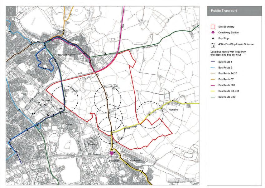
This document has been prepared by
    Milton Keynes Council’s Urban Design
    and Landscape Architecture Team.

    For further information please contact:

    Neil Sainsbury
    Head of Place Making
    Growth, Culture and Economy
    Milton Keynes Council
    Civic Offices
    1 Saxon Gate East
    Milton Keynes MK9 3EJ
    T   +44 (0) 1908 252708
    F   +44 (0) 1908 252329
    E   Neil.Sainsbury@Milton-keynes.gov.uk

2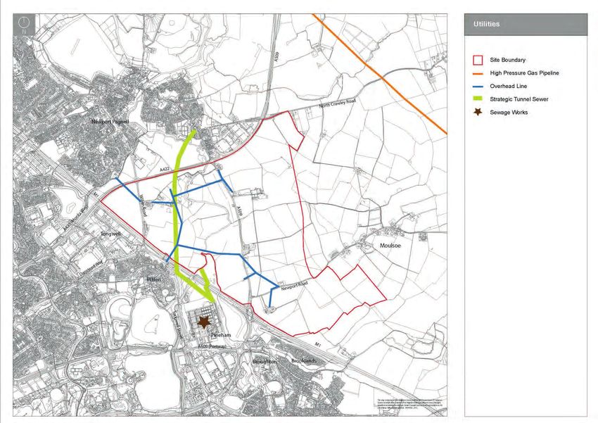
Contents

SECTION 1                                        INTRODUCTION     SECTION 3              VISION AND DEVELOPMENT PRINCIPLES   SECTION 6                                   NEXT STEPS

1.1   Introduction                                            7   3.1   Introduction                                    33

1.2   Oxford - Cambridge Arc                                  9   3.2   Vision                                          33   6.1   Outline Applications                          55

1.3   Role of Development Framework                           9   3.3   Development Principles                          34   6.2   Design and Access Statements                  55

1.4   Community Engagement                                    9   3.4   Core Concept                                    35   6.3   Design Codes                                  55

1.5   Status of Development Framework                         9   SECTION 4                          DEVELOPMENT FRAMEWORK   6.4   Reserved Matters Applications                 55

1.6   Planning Policy Background                              9                                                              6.5   Indicative Programme and Milestones           55
                                                                  4.1   Introduction                                    37
1.7   Housing Infrastructure Fund (HIF) Bid                  11
                                                                  4.2   Landscape and Open Space Strategy               37
1.8   MK Futures 2050                                        11
                                                                  4.3   Movement Framework                              40

                                                                  4.4   Land Use                                        45

SECTION 2                              THE SITE AND ITS CONTEXT   4.5   Character                                       47

                                                                  4.6   Sustainability                                  50
2.1   Introduction                                           13

2.2   Milton Keynes East                                     13
                                                                  SECTION 5                                       DELIVERY
2.3   Surrounding Area and Edge Conditions                   15

2.4   Topography, Views and Drainage                         17   5.1   Phasing                                         53

2.5   Landscape Character                                    19   5.2   Infrastructure Delivery                         53

2.6   Habitat and Vegetation                                 21   5.3   Equalisation                                    53

2.7   Access and Movement                                    22   5.4   Management and Maintenance                      53

2.8   Facilities                                             25

2.9   Heritage and Surrounding Built Character               26

2.10 Environment                                             27

2.11 Utilities                                               28

2.12 Conclusions                                             29

                                                                                                                                                                                      3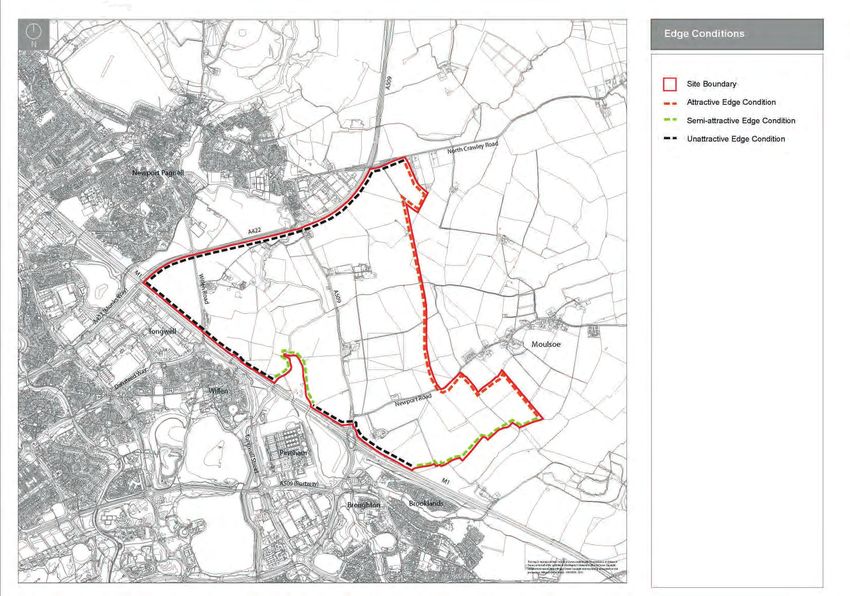
FIGURES

    Figure 1.1    Site Location                                 7   Figure 3.1   Concept Plan                                35

    Figure 1.2    Boundary of the Allocation and Development        Figure 4.1   Landscape and Open Space Strategy           39
                  Framework Area                                8
                                                                    Figure 4.2   Movement Framework                          41
    Figure 2.1    Land Ownership                               14
                                                                    Figure 4.3   Illustrative High Street Cross Section
    Figure 2.2    Edge Conditions                              16                Short-Term Arrangement                      42

    Figure 2.3    Topography                                   17   Figure 4.4   Illustrative High Street Cross Section
                                                                                 Long-Term Arrangement                       43
    Figure 2.4    Drainage                                     18
                                                                    Figure 4.5   Illustrative Primary Street Cross Section   44
    Figure 2.5    Landscape Character LCA 2d                   19
                                                                    Figure 4.6   Indicative Character Areas                  46
    Figure 2.6    Landscape Character LCA 4d                   20
                                                                    Figure 4.7   Indicative Development Framework Plan       51
    Figure 2.7    Habitat and Vegetation                       21

    Figure 2.8    Public Transport                             22   TABLES
    Figure 2.9    Existing Road Hierarchy                      23
                                                                    Table 4.1    Open Space Standards                        38
    Figure 2.10   Public Rights of Way                         24
                                                                    Table 4.2    Indicative Character Typologies             49
    Figure 2.11   Facilities                                   25

    Figure 2.12   Heritage                                     26

    Figure 2.13   Environment                                  27

    Figure 2.14   Utilities                                    28

    Figure 2.15   Opportunities and Constraints                29

4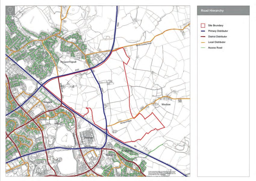
5
Milton Keynes East Strategic Urban Extension Development Framework SPD (Consultation Draft)

                                                                                                       SECTION 1
                                                                                                  INTRODUCTION

                                                                                                     1.1   Introduction

                                                                                                     1.2   Oxford - Cambridge Arc

                                                                                                     1.3   Role of Development Framework

                                                                                                     1.4   Community Engagement

                                                                                                     1.5   Status of Development Framework

                                                                                                     1.6   Planning Policy Background

                                                                                                     1.7   Housing Infrastructure Fund (HIF) Bid

                                                                                                     1.8   MK Futures 2050

6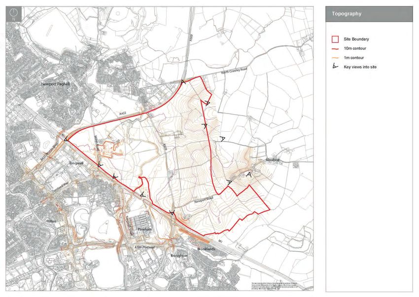
Urban Design & Landscape Architecture
1.1 Introduction
1.1.1 Milton Keynes will see the delivery of at least
26,500 new homes within the Borough between
2016 and 2031. Milton Keynes East is allocated
within Plan:MK for a mixed residential and
employment development. The Milton Keynes
East Strategic Urban Extension (MKE SUE)
will deliver around 5,000 new homes, 105 ha of
employment land, a comprehensive transport
network and supporting social and green
infrastructure.
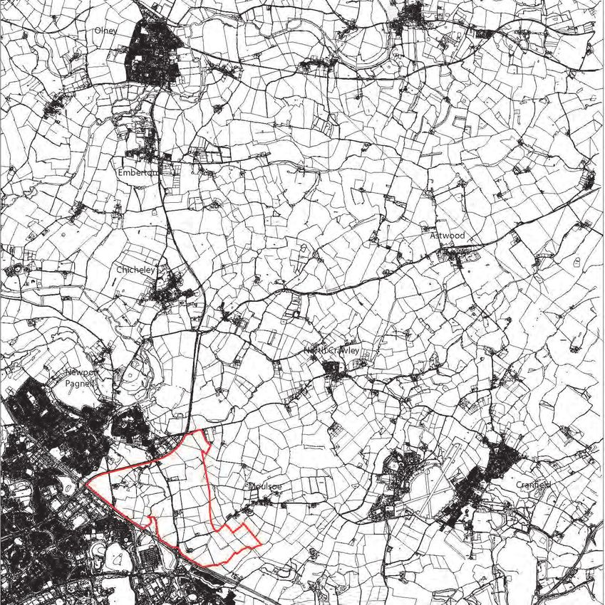
1.1.2 Milton Keynes East lies to the south-east of
Newport Pagnell (figure 1.1).The MKE SUE
covers an area of approximately 461 hectares
on the eastern edge of Milton Keynes (figure
1.2).
Figure 1.1 Site Location
7
www.milton-keynes.gov.uk/udla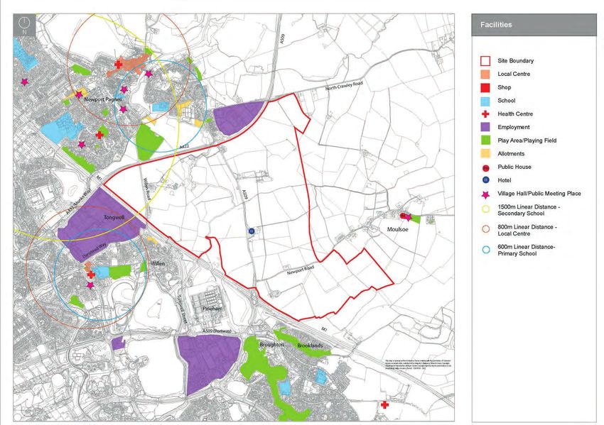
Milton Keynes East Strategic Urban Extension Development Framework SPD (Consultation Draft)

                                  Newport Pagnell

                                                         A509

                                                                                                  Lond
                                                                                                       o
                                                                                                    n Ro
                                                                                                       ad

                                                                                                                         Moulsoe

                            Tongwell

                                             Willen                                 M1

                                                                                 Pineham

                                                                                                            Brooklands
    Figure 1.2 Boundary of the allocation and Development Framework Area

8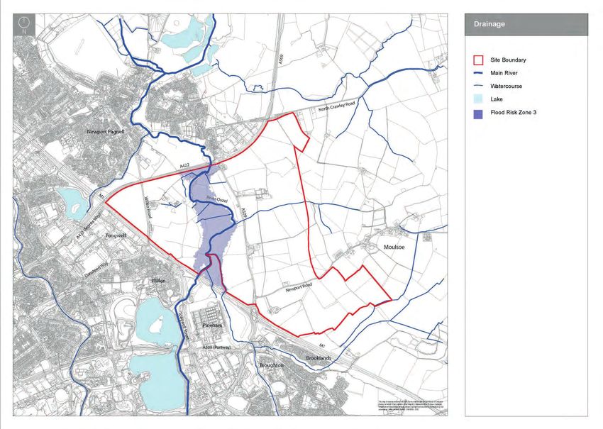
Urban Design & Landscape Architecture
1.2 Oxford - Cambridge Arc 1.2.4 Whilst East West Rail and the Expressway will principles set out in the adopted Plan:MK. 1.5 Status of Development Framework
not unlock development at MKE, the site is Alternative solutions and land use arrangements
1.2.1 In March 2016, the National Infrastructure well placed within the Oxford-Cambridge Arc to could come forward as part of the planning 1.5.1 The Development Framework will be adopted
Commission (NIC) was asked to provide deliver transformational growth around Milton application process and should explain the as a Supplementary Planning Document
Government with proposals and options to Keynes. reasons for any significant differences in (SPD). The Development Framework accords
maximise the potential of the Cambridge- approach. with Plan:MK and the National Planning Policy
Milton Keynes-Oxford arc as a connected, 1.3 Role of Development Framework Framework.
knowledge-intensive cluster that competes on a 1.4 Community Engagement
global stage, protecting the area’s high quality 1.3.1 The preparation of a Development Framework 1.5.2 It has been prepared according to the Town and
is an essential first step to guide all future 1.4.1 The Development Framework has been
environment, and securing the homes and jobs Country Planning (Local Planning) (England)
stages of development. It establishes a context prepared by Milton Keynes Council, in
that the area needs. Regulations 2012. These regulations require
for planning applications and design codes, consultation with other stakeholders and the
that the SPD is subject to public consultation.
which will follow on and contain more detailed main landowner interests. They have provided
1.2.2 The Commission’s final report “Partnering for
proposals. technical and supporting information to provide
Prosperity: a new deal for the Cambridge - 1.5.3 The Development Framework supports the
the basis for the Development Framework.
Milton Keynes - Oxford Arc” was published in implementation of Policy SD12 and other
1.3.2 The Development Framework
November 2017. The central finding of the relevant policies within Plan:MK. As an
establishes: 1.4.2 A Local Stakeholder Group has been
report was that rates of house building will SPD, the Development Framework would be
• Vision established to facilitate engagement on
need to double - delivering up to one million an important material consideration in the
• Spatial disposition of land uses the Framework and on future stages of the
new homes by 2050 - if the arc is to achieve its determination of future planning applications for
• Development principles development process.
economic potential. the development of MKE SUE.
• Infrastructure delivery
1.4.3 There has been an ongoing process of
1.2.3 National investment in the East West Rail 1.6 Planning Policy Background
engagement with the local community and
project and the proposed Oxford-Cambridge 1.3.3 A key objective of the Development Framework landowners/developers and service providers
Expressway is central to achieving the is to ensure that the MKE SUE is brought Plan:MK
in the preparation of the Draft Development
report’s vision. These schemes will enhance forward in a strategic and comprehensive
Framework.
connectivity across the arc, as well as improving manner. Given that the MKE SUE as a whole is 1.6.1 Plan:MK was adopted in March 2019 and
connections with international gateways such owned by a number of parties, the Development 1.4.4 Two workshops were held in October 2018 constitutes the Development Plan guiding future
as Heathrow. But crucially, these schemes can Framework looks holistically at the development with the Local Stakeholder Group in order to applications on this site.*
play a key role in tackling the arc’s housing of the site. The Development Framework will understand their vision and objectives for MKE,
1.6.2 Policy SD12 (outlined on page 10) allocates
crisis, unlocking major new development help to speed up housing delivery by adding with a number of conceptual plans and ideas
MKE SUE and establishes the core principles
locations and enabling transformational growth certainty to the planning process. discussed. A further meeting of the stakeholder
governing how it should be developed. A core
around existing towns and cities. group took place on 19th December 2018 to
1.3.4 The Development Framework provides criteria of Policy SD12 is that development on
further evolve the vision and objectives.
guidance and further detail to the development MKE SUE can commence once the necessary
* The development plan also includes the Council’s Waste and Minerals DPDs, Site Allocations Plan 2018 and any applicable Neighbourhood Plans. At this time no made Neighbourhood Plans cover this site.
9
www.milton-keynes.gov.uk/udla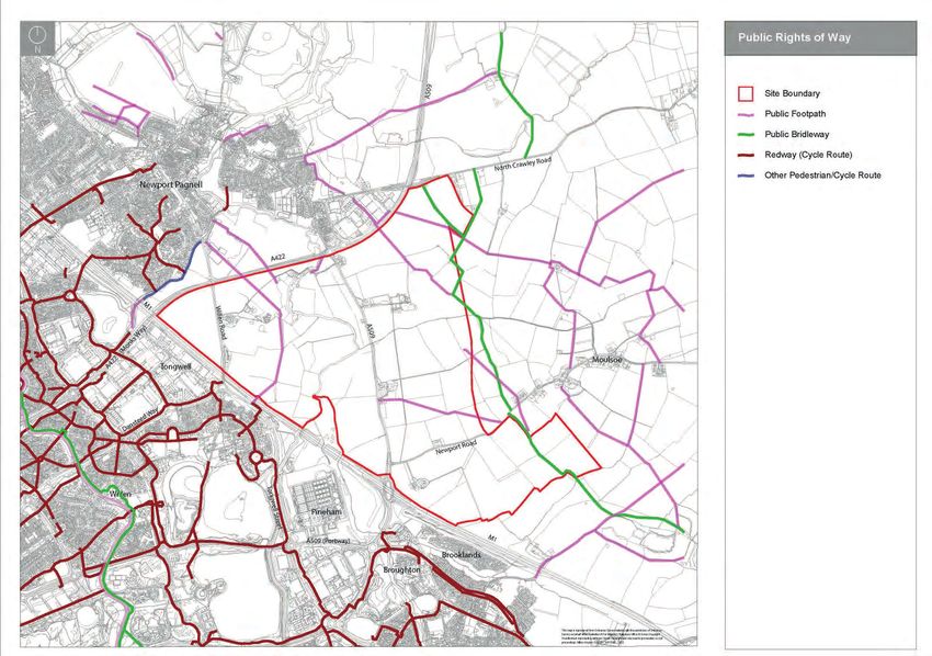
Milton Keynes East Strategic Urban Extension Development Framework SPD (Consultation Draft)

             infrastructure required to make the site
             deliverable is funded and is being delivered.
                                                                              Policy SD12
             There are a number of other Plan:MK policies,                    Milton Keynes East Strategic Urban Extension
             most notably Policies SD1 and SD9, which will
                                                                              A. Land is allocated at Milton Keynes East – as shown on the Key Diagram and Policies Map – for a comprehensive new residential and employment
             have implications for the development of the
                                                                                  development to meet the long-term needs of Milton Keynes. Development can commence once the necessary strategic infrastructure required to make the
             MKE SUE.
                                                                                  site deliverable is funded and is being delivered. In that circumstance, the development of the site will be allowed to proceed within the plan period as an
                                                                                  additional source of housing and employment land supply.
     1.6.3   Plan:MK also requires a Development
                                                                              B. Development will be brought forward in line with all relevant policies in Plan:MK, particularly Policies SD1, SD9, SD10 and INF1. A comprehensive
             Framework for MKE SUE to be adopted prior to
                                                                                  development framework for the site will be prepared in accordance with Policies SD1, SD9, SD10 and INF1 and approved by the Council prior to planning
             any planning permission being granted.
                                                                                  permissions being granted.
                                                                              C. The development framework and subsequent applications for planning permission will establish the quantum and form of development in more detail, but
             National Planning Policy Framework
                                                                                  proposals for development will be expected to meet the following criteria:
                                                                                  1.   Delivery of around 5,000 new homes, including at least 1,475 homes within the plan period, providing a range of sizes, types and tenures, including
     1.6.4   The National Planning Policy Framework
                                                                                       affordable housing, in accordance with other policies in the Plan.
             (February 2019) includes a presumption in
                                                                                  2.   Around 105 hectares of land for a mix of employment uses, complementing the role and function of CMK.
             favour of sustainable development. “For
                                                                                  3.   Associated infrastructure including primary and secondary education, community facilities, health, retail and local services and a hotel. The
             decision-taking this means approving
                                                                                       development should comprise at least one district and/or local centre(s), of a scale commensurate to the needs of the new community and that would
             development proposals that accord with an up-
                                                                                       not adversely affect the viability and vitality of Newport Pagnell district centre, with a co-location of key facilities.
             to-date development plan without delay” (para
                                                                                  4.   The phased introduction of a comprehensive network of transport infrastructure in line with the Local Investment Plan, to include grid road
             11).
                                                                                       connections to H4/V11 to the west and improved highway connections to Newport Pagnell and Central Milton Keynes (CMK), including new and/or
                                                                                       enhanced vehicular crossings of the M1, involving highway works on and off-site.
     1.6.5   The NPPF (para 72) states that “The supply
                                                                                  5.   A corridor of land safeguarded for a fast mass-transit system, and associated infrastructure, enabling connectivity to CMK and other key destinations.
             of large numbers of new homes can often
                                                                                       The width of the corridor should be sufficient to enable a range of possible transit solutions to come forward whilst also ensuring the efficient use of
             be best achieved through planning for larger
                                                                                       land for achieving the scale of development proposed within this policy.
             scale development, such as new settlements
                                                                                  6.   A network of segregated, and where appropriate grade-separated, new and enhanced footpaths, cycleways and bridleways (including redways) to
             or significant extensions to existing villages
                                                                                       connect to existing routes, beyond the site, including provision of appropriate pedestrian and cyclist crossings of the A422 and suitable safe and
             and towns, provided they are well located and
                                                                                       attractive crossings of the M1 as appropriate.
             designed, and supported by the necessary
                                                                                  7.   A strategic green infrastructure framework and network of green spaces to meet strategic and local requirements that follows guidance in the
             infrastructure and facilities.
                                                                                       Council’s Landscape Character Assessment and Green Infrastructure Strategy to ensure ecological connectivity, protect the identity and character of
                                                                                       nearby settlements and mitigate any significant impacts on the landscape in accordance with Policy NE5.
     1.6.6   Local planning authorities should:
                                                                                  8.   The creation of a linear park through the site that broadly correlates with the River Ouzel floodplain and existing green infrastructure assets of value
             a) consider the opportunities presented by
                                                                                       within and adjacent to it.
             existing or planned investment in infrastructure,
                                                                                  9.   Be informed by appropriate surveys of archaeology, built heritage and ecology with appropriate mitigation of impact as consistent with other policies
             the area’s economic potential and the scope
                                                                                       of the Plan and the NPPF. An archaeological field study, including a Geophysical Survey, where appropriate following desk-based assessment, will
             for net environmental gains;b) ensure that their
                                                                                       be required to identify potential below ground archaeology. Where feasible, the Council will expect below ground archaeology to be kept in situ in
             size and location will support a sustainable
                                                                                       preference to its removal.
             community, with sufficient access to services
             and employment opportunities within the

10
Urban Design & Landscape Architecture
development itself (without expecting an New Residential Design Guide SPD 1.7 Housing Infrastructure Fund (HIF) context for statutory planning over the period
unrealistic level of self-containment), or in Bid and sets out:
larger towns to which there is good access;c) 1.6.10 The Council adopted the New Residential • how sustained, planned and significant long
set clear expectations for the quality of the Development Design Guide as a Supplementary 1.7.1 Milton Keynes Council as submitted a bid to the term growth will benefit existing communities,
development and how this can be maintained Planning Document in April 2012. The Design UK Government’s Housing Infrastructure Fund improving opportunities and quality of life for
(such as by following Garden City principles), Guide provides guidance on the structuring (HIF) to fund the early phases of infrastructure, everyone who lives and spends time here;
and ensure that a variety of homes to meet the elements of a large development (e.g. the including highways and primary school, that are • how we can work with partners including central
needs of different groups in the community will movement network, parking), as well as more required to enable to delivery of the allocation government, the housebuilding industry and
be provided;d) make a realistic assessment of detailed guidance at the scale of the street under Plan:MK. The Council anticipates a HIF landowners, local communities and stakeholders
likely rates of delivery, given the lead-in times and individual dwelling. The Development bid decision in May/June 2019. to deliver successful, inclusive growth; and
for large scale sites, and identify opportunities Framework should be read alongside the • how we can ensure that development is
for supporting rapid implementation. Design Guide, and new housing development 1.8 MK Futures 2050 managed in a planned way, that focuses on
within MKE should take account of the guidance creating the place that Milton Keynes wants to
Mobility Strategy (LTP4) 1.8.1 In their 2016 report ‘Making a Great City be in the future.
in the Design Guide.
Greater’, the MK Futures 2050 Commission
1.6.7 The new Local Transport Plan (LTP4), Mobility proposed a long-term 2050 vision and Six Big
Other Planning Guidance 1.8.3 The Strategy will endeavour to put people at the
Strategy for Milton Keynes, runs from 2018 Projects to create a stronger future for the heart of the growth story for the city, creating
to 2036. It sets out the long term transport city. These Six Big Projects were intended to
1.6.11 There are other SPDs and Supplementary a plan for how we can maintain the best of the
strategy and goals, and contains plans for be transformational and interdependent. They
Planning Guidance (SPG) produced by Milton place, fix the things that could work better, and
transport schemes and projects in the short, included delivering a movement network that
Keynes Council which should be read in build a city that works for everyone, not just
medium and long term. The Plan was adopted works for everyone, so that there are efficient,
conjunction with this SPD (https://www.milton- those living in the new homes or working in new
by the Council in March 2018. cost-effective and reliable alternatives to using
keynes.gov.uk/planning-and-building/planning- jobs, or those that have access to a private car
the private car; helping to attract investment to travel around the city. Inclusive growth is
policy/dpd-s-and-spds-spgs).
1.6.8 The Strategy sets an ambitious mode shift and build the retail, leisure, employment and a thread that will run through the Strategy for
target to achieve a better balance between residential offer in Central Milton Keynes (CMK)
1.6.12 The following publications have also informed 2050.
private car uses and alternative forms of travel. so it becomes a vibrant, buzzing place that
the preparation of this Framework:
The need to reduce transport pollution and CO2 attracts people, activity and investment; and
• By Design (DETR/CABE, 2000) 1.8.4 The challenge for the Development Framework
emissions, protect the natural environment and developing a city centre university, to create our
• Urban Design Compendium (EP/Housing and Plan:MK is to deliver development needed
promote improved public health and wellbeing is own talent pool of graduates to help build our
Corporation, 2000) to meet the needs of Milton Keynes now, but
a key part of the Strategy. future economy. The 2050 Strategy for Milton
• Manual for Streets (DfT/DCLG/Welsh Assembly, also to be sufficiently flexible and forward
Keynes is being designed to guide the next thinking to pave the way for a future Milton
2007)
1.6.9 One of the Mobility Strategy’s Delivery Plan phase of the city’s growth, building on the work
• Safer Places - the Planning System and Crime Keynes that the Strategy will set out.
initiatives is to ensure that new development of the Commission and the current delivery of
Prevention (ODPM/Home Office, 2003)
areas have capacity for mass transit access. the six projects.
• Better Places to Live (DTLR/CABE, 2001).
1.8.2 The Strategy for 2050 will set out how the
sustainable growth ambition for Metropolitan
Milton Keynes will be delivered and provide a
11
www.milton-keynes.gov.uk/udlaMilton Keynes East Strategic Urban Extension Development Framework SPD (Consultation Draft)
SECTION 2
THE SITE AND ITS CONTEXT
2.1 Introduction
2.2 Milton Keynes East
2.3 Surrounding Area and Edge Conditions
2.4 Topography, Views and Drainage
2.5 Landscape Character
2.6 Habitat and Vegetation
2.7 Access and Movement
2.8 Facilities
2.9 Heritage
2.10 Environment
2.11 Utilities
2.12 Conclusions
12Urban Design & Landscape Architecture
2.1 Introduction 2.2.5 There are small groups of dwellings around
Caldecote Farm (Willen Road) and Pyms
2.1.1 “A thorough appreciation of the overall site Stables (London Road). There a number of
context is the starting point for designing a isolated dwellings, including Hermitage Farm
distinct place” (Urban Design Compendium, (Newport Road).
2000). This section sets out the context of
the SUE and the surrounding area. The 2.2.6 The major existing feature of MKE is the River
constraints and opportunities identified help to Ouzel which runs south-north through the site.
shape the Development Framework. Individual
planning applications should be supported by a
contextual analysis as part of the preparation of
Design and Access Statements.
2.2 Milton Keynes East
2.2.1 Milton Keynes East is located to the east of View looking east from Willen Road M1 bridge View looking north from southern edge of site
Milton Keynes on the eastern side of the M1
and comprises a total area of approximately
461 hectares. To the east of the area is open
countryside and the village of Moulsoe, to the
north is Newport Pagnell, and to the west is the
M1 and the built-up area of Milton Keynes.
2.2.3 The boundary of the site is provided by the A422
and the A509 to the north, with the M1 to the
south. The eastern edge of the site does not
follow any identifiable boundary on the ground.
2.2.4. The majority of the area is in agricultural use.
There is an existing hotel on London Road
and a travellers site on Willen Road. An area
of land to the east of Willen Road, south of
Caldecote Farm, is being worked for sand and
gravel extraction.
View looking west from Moulsoe View looking south from Moulsoe
13
www.milton-keynes.gov.uk/udlaMilton Keynes East Strategic Urban Extension Development Framework SPD (Consultation Draft)
2.2.7 The site is in a number of different ownerships
(including developer agreements with
landowners) as shown on fig 2.1:
(i) Berkeley Group
LAND OWNERSHIP
(ii) Bloor Homes
(iii) Segro(Newport Pagnell) Limited/Roxhill Berkeley Group
(iv) Milton Keynes Council Bloor Homes
Milton Keynes Council
2.2.8 There are a number of smaller parcels of land in
other ownerships. Segro/Roxhill
Other Landowners
Figure 2.1 Land Ownership
14Urban Design & Landscape Architecture
2.3 Surrounding Area and Edge 2.3.6 Adjoining the southern edge of the site, adjacent
Conditions to the M1, lies a triangle of land alongside the
River Ouzel which is owned by the Parks Trust.
Surrounding Area
2.3.1 The built-up area of Milton Keynes lies to
the south and west of MKE. The residential
areas of Willen and Brooklands are adjacent
to the SUE, separated by the M1. Willen was
developed around the existing village during
the 1980s. Brooklands is part of the Eastern
Expansion area which has been developed over
the last ten years.
2.3.2 To the south also lies Cotton Valley Sewage
Works at Pineham and the Tongwell
employment area. M1 motorway Moulsoe church
2.3.3 The village of Moulsoe lies to the east of the
SUE. It has developed in a linear form along
Newport Road.
2.3.4 To the north-west of the SUE lies the town
of Newport Pagnell. As at the 2011 Census,
Newport Pagnell had a population of 15,118,
and a total of 6,214 dwellings. Land has been
allocated for residential development on the
eastern edge of the town to the north of North
Crawley Road at Tickford Fields.
2.3.5 To the south of the site is the Ouzel Valley
linear park which provides recreation and flood
attenuation for the whole of Milton Keynes. To
the north of the site the linear park follows the
River Ouzel through Newport Pagnell.
River Ouzel Newport Pagnell town centre
15
www.milton-keynes.gov.uk/udlaMilton Keynes East Strategic Urban Extension Development Framework SPD (Consultation Draft)
Edge Conditions
2.3.6 Edge conditions are important to evaluate, as
they form the interface with the existing context.
Depending on their nature, they can inform a
certain development or open space response.
• The M1 is a heavily trafficked road which
provides an unattractive edge to the site due
to air and noise pollution, and visual impact.
The motorway currently represents a barrier
to movement and functional as well as visual
integration to Milton Keynes to the west.
• The A422/A509 is a heavily trafficked dual
carriageway, which provides an unattractive
edge to the site. It has a mature hedgerow
boundary which reduces visibility into and out
of the site. The dual carriageway represents a
barrier to movement.
• The eastern edge of the site looks out onto
open countryside and to the village of Moulsoe.
Development along this edge will have attractive
views of open countryside. For much of its
length this boundary does not follow any
identifiable feature on the ground.
• The south-eastern boundary follows existing
hedgerow field boundaries. Whilst this edge
overlooks open countryside, its attractiveness is
reduced by its proximity to the motorway.
Figure 2.2 Edge Conditions
16Urban Design & Landscape Architecture
2.4 Topography, Views and Drainage
Topography and Views
• The land is relatively flat to the west of London
Road (A509).
• In the eastern part of the site, the land rises
up from London Road and the M1 towards
Moulsoe.
• There are limited views into the site from the
M1 and A422/A509. Views into the site along
the southern edge are provided from bridges
crossing the M1.
• Views into the site along the eastern edge of the
site are provided from Moulsoe, and the public
rights of way which lie just outside of the site
boundary.
• There are long distance views from within the
site of the Greensand Ridge to the south, CMK,
and the clay plateau to the north. There are
shorter distance views from the elevated south-
eastern parts of the site to Brooklands and
Magna Park.
• A Landscape Visual Impact Assessment (LVIA)
should be undertaken to assess the impact
of the development on the landscape and to
identify appropriate mitigation measures.
Figure 2.3 Topography
17
www.milton-keynes.gov.uk/udlaMilton Keynes East Strategic Urban Extension Development Framework SPD (Consultation Draft)
Drainage
• The River Ouzel is a main river. The
Environment Agency carries out maintenance,
improvement or construction work on main
rivers to manage flood risk.
• Milton Keynes Council as the Lead Local
Flood Authority, and Bedford Group of Internal
Drainage Boards as a statutory flood risk
management authority work in partnership
under a Memorandum of Understanding, and
have jurisdiction over all ordinary watercourses
within the Borough of Milton Keynes.
• Some watercourses running through the site are
operated and maintained by the Bedford Internal
Drainage Board. Bedford IDB requirements will
need to be complied with.
• All new development must be set back at a
distance of at least 8 metres from any main
rivers, at least 9 metres from all other ordinary
watercourses, or at an appropriate width as
agreed by the Environment Agency, Lead Local
Flood Authority or Internal Drainage Board,
in order to provide an adequate undeveloped
buffer zone.
Figure 2.4 Drainage
18Urban Design & Landscape Architecture
2.5 Landscape Character 2.5.5 The MKLCA sets out a number of guidelines
for countryside management relating to the
2.5.1 Milton Keynes Council commissioned a
character areas and to new development:
Landscape Character Assessment (June 2016)
which was prepared by Gillespies. The Milton
2.5.6 The MKLCA includes the following general
Keynes Landscape Character Assessment
guidelines for the River Valley LCT:
(MKLCA) provides a detailed review of the
• Encourage the reversion of arable to pasture
landscape character of the Borough and
within floodplain.
describes and evaluates Landscape Character
• Promote improvements to the river, water edge
Types (LCTs) and Landscape Character Areas
and pond habitats to encourage biodiversity
(LCAs) within the Borough.
value through marginal planting and localised
2.5.2 The MKE SUE lies within two LCTs: River Valley bank profiling and sympathetic maintenance of
and Clay Lowland Farmland. The River Valley drainage ditches.
LCT comprises the river valley floodplains of • Promote the management of riparian vegetation
the River Great Ouse, and its main tributaries including floodplain pollards, new specimens
including the River Ouzel, and the River Tove. including Black Poplar and where appropriate
The Clay Lowland Farmland LCT comprises more extensive areas of wet woodland.
a sweep of relatively low lying land that wraps • Encourage the increased use of the river for
around the eastern and south east edge of appropriate recreation that respects landscape
Milton Keynes. character.
• Improve PRoW connections from urban and
2.5.3 Key characteristics of the River Valley LCT
rural settlements to the right of way network
include: slow flowing meandering river in
promoting new links where absent.
sinuous valley floor; areas of pasture close to
• Encourage appropriate management of all
the river; open field patterns; weirs and historic
drainage ditches to improve wildlife value, by
mills; river inconspicuous within the landscape;
improving water quality and establishing grass
and tranquil character. Key characteristics of
‘verges’.
the Clay Lowland Farmland LCT include: low
• Consider if there is further scope to minimise
lying and generally flat landscape; mixed arable,
the visual impact of the main transport corridors
pasture and recreational land uses; limited
including the M1 by introducing additional
woodland cover; few field trees; dominated by
planting.
major transport routes; large scale arable fields
• Prevent built development in the floodplain.
with overgrown hedges; and extensive and open
• Promote the creation of additional public
views to the clay plateau and towards Milton
bridging points. Figure 2.5 Landscape Character LCA 2d (Source:
Keynes. Landscape Character Assessment - June 2016)
• Improve right of way signage.
2.5.4 The MKE SUE site lies within two LCAs: 2d
- Ouzel North Urban River Valley; and 4a -
Broughton to Tickford Clay Lowland Farmland.
19
www.milton-keynes.gov.uk/udlaMilton Keynes East Strategic Urban Extension Development Framework SPD (Consultation Draft)
2.5.7 Within LCA 2d - Ouzel North Urban River Valley, 2.5.9 Within LCA 4a - Broughton to Tickford Clay
the following specific guidelines apply: Lowland Farmland, the following specific
• Promote the continued management and guidelines apply:
enhancement of the River Ouzel corridor and • Develop a strategy to screen the M1 through
access from the adjacent urban areas. additional off-site woodland planting and
• Promote the development of the Ouzel Valley management of the on-site highway planting.
Linear Park extending the Ouzel Valley Park
northwards between Willen and Newport
Pagnell.
2.5.8 The MKLCA includes the following general
guidelines for the Clay Lowland Farmland LCT:
• Ensure earthworks adjacent to the M1 corridor
are designed and planted to effectively screen
residential properties but also ensure that the
profiles are shaped and planted to harmonise
with the local landscape character as seen from
within city and from the rural areas east of the
M1, and ensure that the M1 Ridge (noise bund)
matures into a strong tree-covered landscape
feature.
• Promote the extended use of the area for
informal recreation.
• Ensure right of way access and signage from
urban areas into the rural areas is clear and well
maintained.
• Promote indigenous plant species and use of
species of local provenance wherever possible.
• Promote hedgerow restoration and
improvements throughout the area to provide
visual and ecological links between existing and
proposed woodland.
• Promote the creation of new woodland blocks
and copses throughout the area to strengthen Figure 2.6 Landscape Character LCA 4a (Source:
the character of the area. Landscape Character Assessment - June 2016)
20Urban Design & Landscape Architecture
2.6 Habitat and Vegetation
• The site includes wildlife corridors along the M1
and along the River Ouzel which runs south-
north through the site.
• There are a number of areas of woodland and
lengths of hedgerow within the site. These
hedgerows provide habitat and connectivity
for wildlife and open space corridors, contain
individual mature trees and are also part of the
historic environment.
• The Ouzel Valley Linear Park lies to the south
of the site and could be extended into the site,
with future potential to continue into Newport
Pagnell.
Figure 2.7 Habitat and Vegetation
21
www.milton-keynes.gov.uk/udlaMilton Keynes East Strategic Urban Extension Development Framework SPD (Consultation Draft)
2.7 Access and Movement
Public Transport
• There are existing bus routes through the site,
which run along Willen Road, London Road
and Newport Road. These bus routes provide
connections to Newport Pagnell, CMK and
Cranfield.
• The Milton Keynes Coachway interchange,
which supports inter-city coach services, is
located close to junction 14 of the M1.
Figure 2.8 Public Transport
22Urban Design & Landscape Architecture
Existing Road Hierarchy
• The site is bounded to the south by the M1.
There are currently three road crossings of
the motorway. Junction 14 of the M1, which is
located at the south-eastern corner of the site, is
the source of existing traffic congestion.
• The A422/A509 runs to the north of the site and
connects Milton Keynes with Wellingborough,
via Olney. The road is dual carriageway from
Milton Keynes to the Chicheley Hill roundabout.
• There are two roads that cross the SUE in a
north-south direction - Willen Road and London
Road. These roads connect Milton Keynes to
Newport Pagnell and connect to the A422/A509
via roundabout junctions.
• In addition, there is the more local Newport
Road which connects Moulsoe to Milton Keynes
via London Road, and also provides access to
Cranfield.
Figure 2.9 Existing Road Hierarchy
23
www.milton-keynes.gov.uk/udlaMilton Keynes East Strategic Urban Extension Development Framework SPD (Consultation Draft)
Pedestrian and Cycle Routes
• There is a network of redways within Milton
Keynes to the south of the M1, and within
Newport Pagnell. There is the opportunity for
the SUE to connect into this network.
• There are a number of existing public rights of
way which cross MKE.
• Four public footpaths connect from the site
into Newport Pagnell, but the dual carriageway
A422/A509 provides a barrier to crossing.
• There is a network of public footpaths outside
of the site within the open countryside around
Moulsoe. There is the opportunity for the SUE
to connect into this network.
• In addition to public rights of way, there is a
network of footpaths within Newport Pagnell that
can connect into the SUE.
Figure 2.10 Public Rights of Way
24Urban Design & Landscape Architecture
2.8 Facilities
• Within the allocation there are no community
facilities of note, including formal open space.
However, there is the Coach House Hotel on
London Road.
• Outside of the allocation area a range of
facilities and amenities serving existing
communities. These facilities are unlikely
to be capable of serving MKE and existing
communities. New facilities within the allocation
will therefore be required in line with Plan:MK.
• Newport Pagnell provides a range of facilities
including health centres, secondary and primary
schools and sport and leisure facilities.
• Newport Pagnell town centre is a district centre
with a good range of retail facilities, including
pubs, restaurants, pharmacies, a library, a small
Co-op supermarket.
• There are health centres in Willen and
Brooklands.
• Moulsoe has a pub, a village hall and a play
area.
• Local employment opportunities are provided
at Tongwell and Interchange Industrial Park,
Newport Pagnell.
Figure 2.11 Facilities
25
www.milton-keynes.gov.uk/udlaMilton Keynes East Strategic Urban Extension Development Framework SPD (Consultation Draft)
2.9 Heritage and Surrounding Built
Character
• There is one listed building within MKE (Coach
House Hotel) on London Road.
• Newport Pagnell is a market town established in
medieval times. During the Civil War, the town
became a garrison for parliamentary forces due
to its strategic position as a crossing point of the
river. The town developed in importance in the
coaching trade, particularly on the turnpike road
between London and Northampton. The 19th
century brought improved communications, in
terms of the canal and railway, new industries,
and an expansion in housing areas.
• Willen was an existing community with early
medieval roots around which the new town of
Milton Keynes was built. Saint Mary Magdalene
Church at Willen is a Grade 1 listed building.
• Moulsoe has a rural vernacular character that
has evolved along the Newport Road, and
includes eleven listed buildings, including the
Grade 1 listed Church of St Mary.
• The neighbouring settlements of Newport
Pagnell, Broughton and Willen have
conservation areas which contain a number of
listed buildings.
• The proposed development area has been
subject to little structured archaeological survey
or field evaluation save that undertaken in
relation to the sand and gravel quarries in the
west of the area and proposed M1 widening.
• Archaeological excavation of the former
Willen Road quarry site revealed a ring ditch
representing the ploughed out remains of a
later prehistoric burial mound in addition to Iron
Age and Romano-British settlement. Additional
probable ring ditches and enclosures are Figure 2.12 Heritage
26Urban Design & Landscape Architecture
recorded as cropmarks in the arable fields either
side of the River Ouzel highlighting the potential
for further similar archaeological remains in
these areas and the adjacent meadows.
• Also of significance, yet poorly understood, is
the former medieval and post-medieval hamlet,
manorial site and mill at Caldecote containing
areas of earthwork ridge and furrow and partly
infilled linear water features in addition to strong
potential for related buried archaeological
remains.
• Prior to the submission of a planning
application the development area should be
subject to: (i) an archaeological desk-based
assessment including historic landscape/
hedgerow assessment; (ii) geoarchaeological
deposit modelling of the Ouzel valley to
assess palaeoenvironmental potential; (iii)
field evaluation comprising 100% detailed
magnetometry survey and trial trenching (scope
to be agreed with the local planning authority).
Consideration should also be given to the use
of field-walking/surface artefact collection within
the arable fields; and (iv) earthwork survey and
analysis of the Caldecote mill, deserted village
and manorial complex.
2.10 Environment
• The motorway, and the A422/509 are significant
sources of noise and pollution.
• The River Ouzel valley lies within flood risk
zones 2 and 3.
• A minor aquifer underlies most of the land to the
west of London Road.
Figure 2.13 Environment
27
www.milton-keynes.gov.uk/udlaMilton Keynes East Strategic Urban Extension Development Framework SPD (Consultation Draft)
2.11 Utilities
• Coton Valley Sewage Works is located to the
south of the site at Pineham with the possibility
of connection to it available.
• There is a strategic tunnel sewer which runs
from Pineham Sewage Works in a northerly
direction through the site to Newport Pagnell. A
24 metre easement either side of the sewer will
need to be kept free of any built development.
• There are overhead lines crossing the area,
but these are not considered to be a major
constraint.
Figure 2.14 Utilities
28Urban Design & Landscape Architecture
2.12 Conclusions
2.12.1 Taking into account the opportunities and
challenges identified in this section, the
following factors and principles inform the
preparation of the Development Framework:
Edge conditions
• Built development on the eastern edge of the
site should respect character of Moulsoe village
and open countryside.
• Less noise sensitive development, such as
employment, should be located adjacent to the
M1, and A422/A509 corridor.
• Noise and air pollution sensitive uses should be
set back and buffered from the M1 and A422/
A509.
Topography, views and drainage
• A long term defensible green buffer should be
identified to create a clear separation between
Moulsoe village and the new development.
• A Landscape Visual Impact Assessment (LVIA)
should be undertaken to assess the impact
of the development on the landscape and to
identify appropriate mitigation measures.
Habitat and vegetation
• Existing woodlands should be retained, where
possible, for landscape structuring, ecological,
historical and recreational reasons.
• Existing hedgerows should be retained where
possible. To ensure their long term maintenance
they should be incorporated within the public
realm where practicable.
Figure 2.15 Opportunities and Constraints
29
www.milton-keynes.gov.uk/udlaMilton Keynes East Strategic Urban Extension Development Framework SPD (Consultation Draft)
• The Ouzel Valley linear park lies to the south remains) by field evaluation at the earliest
of the site and could be extended into the site, opportunity and prior to the submission
with future potential to continue into Newport of a planning application. Developers are
Pagnell, in recognition of flood risk and potential recommended to contact the Council’s
to create wetland habitat for wildlife. Archaeology Officer at as early a stage as
possible to discuss individual circumstances.
Access and movement
Environment
• Development should link into the existing
redway and rights of way network, and extend it • Development in flood risk zones 3 and 2 should
into areas of development. be avoided in line with Plan:MK. Opportunity
to use network of watercourses as part of an
Facilities integrated SUDs scheme.
• Mitigation measures to reduce impact of road
• Newport Pagnell provides a range of facilities noise and pollution from M1 and the A422/A509,
including retail, employment, health centres, and from Coton Sewage Treatment Works will
secondary and primary schools and sport and need to be employed.
leisure facilities. However, these are likely to be • All new development must be set back at a
insufficient to meet the needs and demands of distance of at least 8 metres from any main
MKE residents. rivers, at least 9 metres from all other ordinary
watercourses, or at an appropriate width as
Heritage agreed by the Environment Agency, Lead Local
Flood Authority or Internal Drainage Board,
• Development should not adversely affect the in order to provide an adequate undeveloped
setting of the heritage assets within or on the buffer zone.
edge of the site, particularly the hotel within the
site and the grade 1 listed Church of St Mary in Utilities
Moulsoe.
• Masterplanning of the site should protect the • No built development within a 24 metre
integrity and character of Moulsoe village, and easement corridor either side of the tunnel
be respectful of the character of other adjoining sewer.
areas, such as parts of Newport Pagnell close to
the site. Given the level of enclosure separating
it from adjacent areas, and given the scale of
MKE, the development has an opportunity to
create a unique character of its own.
• It will be necessary to identify archaeological
constraints (particularly buried archaeological
30Urban Design & Landscape Architecture
31
www.milton-keynes.gov.uk/udlaMilton Keynes East Strategic Urban Extension Development Framework SPD (Consultation Draft)
SECTION 3
VISION AND DEVELOPMENT
PRINCIPLES
3.1 Introduction
3.2 The Vision
3.3 Development Principles
3.4 Core Concept
32Urban Design & Landscape Architecture
3.1 Introduction 3.2 The Vision
3.1.1 A vision and a set of development principles
Milton Keynes East will become a sustainable, high quality and thriving new community. It will
have been drawn up taking cues from: the
be a place with a unique identity which can complement, but be distinct from, adjoining towns
analysis of the site context; the principles set
and villages. It will be an exemplar of modern town planning that can take forward the proud
out in Plan:MK (namely those within Policies
and successful legacy of place-making locally. It will be based upon a bespoke masterplan-led
SD12, SD9 and SD1); through engagement
approach to create a new settlement for the 21st century that will be sustainable, successful and
with the Local Stakeholder Group and visioning
prosperous in its own right. It will integrate well with existing communities, respond to local context
workshops, in particular; and discussions with
whilst also being future proofed to accommodate new means of mobility and ways of living.
the developers promoting MKE.
It will be designed to foster a strong sense of community and belonging, providing civic spaces for
3.1.2 The vision and development principles provide
community interaction and building, a range of new homes of varying styles and densities, together
the basis for the development of the core spatial
with space for local existing and new businesses to thrive. It will be a welcoming and sensitively
concept for MKE.
designed environment, working with the existing landscape, topography and natural assets to
provide a strong network of connected green spaces whilst also protecting the identity and integrity
of existing local villages. It will provide a wide range of new services and facilities for the benefit
of new and existing communities. Strong internal connectivity will be a key defining characteristic
whilst facilitating strategic through movement of traffic that avoids conflicts with places which are
for the enjoyment of people and habitats for wildlife.
33
www.milton-keynes.gov.uk/udlaMilton Keynes East Strategic Urban Extension Development Framework SPD (Consultation Draft)
3.3 Development Principles • Quality Placemaking: The new community • Economic Role. The site should provide
should be designed to have a clear and unique for a range of employment generating uses,
• Active modes: Walking & cycling will be identity, distinct from adjoining areas. The site maximising its prime location with high
promoted throughout the site with the provision should include a small number of character accessibility to the strategic road network and
of a comprehensive network of footpaths areas to enable the approach to urban design making provision for a wide range of new local
& cycleways, extending the Milton Keynes and place-making to help foster and define employment opportunities. The site should
Redway network into the site, and ensuring separate parts of the new community. The deliver a sustainable blend of uses and activities
good connectivity to adjoining communities of character and identity of the existing adjoining to fit with modern ways of living and working.
Moulsoe, Willen and Newport Pagnell. rural village of Moulsoe will be protected from • Retail & Centres: A ‘heart’ for the site should be
• Permeability: The development will need to new development with quality landscape led provided at a location with pleasant, direct and
include robust and efficient connections within, green buffers. Boundaries with existing urban safe accessibility for new residents, containing
across and out of the development, for all areas of Willen and Newport Pagnell should a blend of higher order facilities and functions.
modes of transport and particularly minimising be sensitively designed to provide distinction Retail space across the site should be provided
the barrier effect of the M1, A509 and A422 between the different communities and to a scale that addresses local needs but does
routes. places, but allow for suitable interaction and not negatively impact on the health or vitality of
• New strategic routes & connections: Through connectivity. Newport Pagnell town centre.
traffic will be directed out of the core of the new • Density. The site should accommodate a mix of • Green and Blue Infrastructure: The River
community, with a new route over the M1 to residential densities to provide for diversity and corridor should be a defining feature of MKE; a
connect to the grid road network on Tongwell distinctiveness across the site whilst protecting place centred around a high quality naturalistic
Street at Willen and allow through traffic to enter the fringe rural character. Higher densities riverine parkland. Development should
Milton Keynes without passing through Junction should be provided in areas with strong integrate existing water-courses and associated
14 of the M1. Strategic routes should facilitate accessibility to public transport and to provide flood zones, including the River Ouzel through
efficient through movement to minimise impact strong frontages to areas of strategic parkland. the centre of the site to provide accessible multi-
on new residential communities. This would provide for natural surveillance and functional open spaces for the benefit of new
• Sustainable movement & rapid transit: the provide accessibility to public open space for and existing local communities. New accessible
community will be designed to accommodate those who may have more limited private open open spaces and parkland should integrate with
accessible, frequent and high quality public spaces. existing strategic open spaces, including good
transport connections at key hubs within • Social & Community: Areas of development, connections towards Willen Lake and through
the site, including being future-proofed to particularly the district centre and residential to Riverside Meadows in Newport Pagnell.
accommodate and integrate with potential mass areas, should be people-centric and be The development should seek to improve
rapid transit as part of a wider system for Milton designed to work for new residents and overall local water management and local flood
Keynes. communities, provide for a wide range of protection.
• Minimised impact of transport corridors: social and community facilities, including new • Biodiversity. New and retained green
The impacts of adjoining transport routes schools (pre-school, primary and secondary), infrastructure should encourage biodiversity
such as the M1, A422 and A509 should be health facilities, social and wider uses. It should gains, protect existing habitats and maximise
minimised through the location of development provide opportunities for people to meet and existing assets as part of the overall network.
and appropriate mitigation measures, such as interact and generate a strong sense of local
landscaping and bunds. community.
34Urban Design & Landscape Architecture
3.4 Core Concept
3.4.1 The Concept Plan (figure 3.1) has been
developed in order to spatially interpret the
vision and development principles for the new
community. The key features of the concept
plan are:
• a linear park based around the River Ouzel
corridor;
• a landscape buffer to Moulsoe;
• a mixed use district centre at the heart of the
main residential area;
• a secondary school close to the district centre;
• four primary schools spread equidistantly
around the residential areas;
• a new road bridge over the M1 providing an
improved link to CMK and the urban area of MK;
and reducing pressure on the A422;
• safeguarded route for a fast mass transit route;
• a park and ride site;
• employment development along the edge of the
motorway;
• pedestrian/cycle connections across the M1 and
A422;
• an outer road to allow through traffic to move
through the site without conflicting with areas of
housing and the people-centric places within the
site;
• Willen Road to be retained and improved;
• partial downgrade of A509 London Road
through the site.
Figure 3.1 Concept Plan
35
www.milton-keynes.gov.uk/udlaMilton Keynes East Strategic Urban Extension Development Framework SPD (Consultation Draft)
SECTION 4
DEVELOPMENT FRAMEWORK
4.1 Introduction
4.2 Landscape and Open Space Strategy
4.3 Movement Framework
4.4 Land Uses
4.5 Character
4.6 Sustainability
36Urban Design & Landscape Architecture
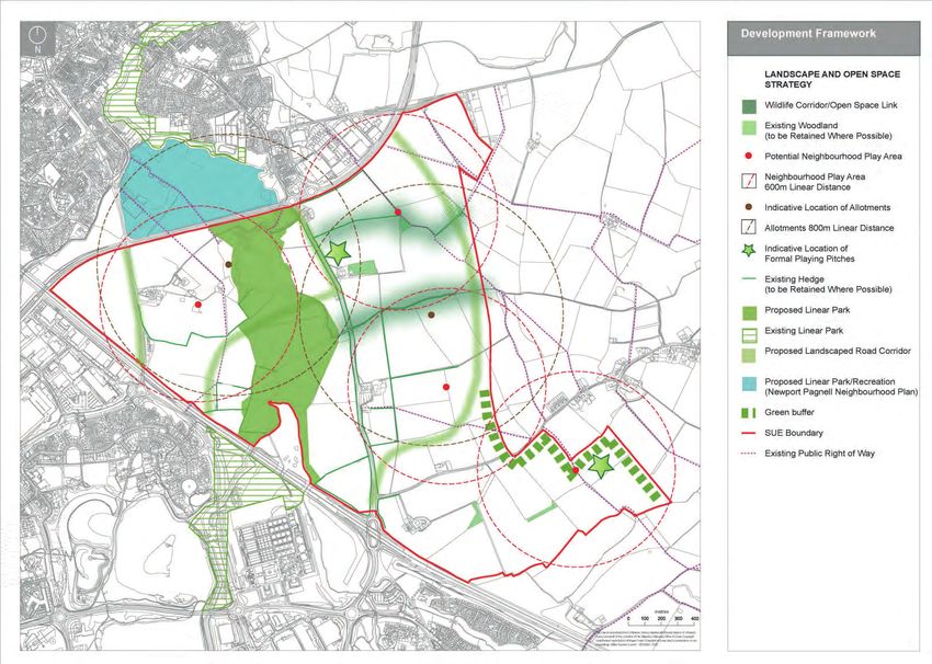
4.1 Introduction within the public realm, rather than included For much of its length a landscaped locally Open Space
within private residential gardens. strategic route will follow this edge of the
4.1.1 The key strands of the Development Framework development. 4.2.13 Open space should be provided in accordance
4.2.5 Developers should undertake arboricultural and with guidance set out in Plan:MK (Policy L4 and
are:
ecological surveys, which should be submitted Appendix C).
• Landscape and Open Space Strategy Edge South of Moulsoe
with their outline planning applications.
• Movement Framework
4.2.14 The design and layout of open spaces must
• Land Uses 4.2.9 An extensive landscape buffer is to be
Edge Treatment respect site specific conditions and functional
• Character maintained in order to provide clear separation
requirements. Open space and recreation
• Sustainability A422/A509 between Moulsoe and the new development.
features, such as play areas, must be designed
Each strand of the Development Framework
4.2.6 The A422/A509 is a dual carriageway with with sufficient space to meet their functional
builds on the policy requirements set out in Areas of Wildlife Interest
an unrestricted speed limit. This does not requirement. Notwithstanding existing site
Plan:MK.
provide an appropriate interface for residential features, open spaces should be provided
4.2.10 Plan:MK Policy NE3 requires the protection
4.2 Landscape and Open Space Strategy development and therefore housing should not in highly accessible locations and integrated
and enhancement of biodiversity in new
directly ront or back onto this edge. Appropriate into the development by being overlooked by
developments. The Framework seeks to protect
Landscape measures should be included to mitigate noise housing.
a network of wildlife corridors, which provide
and air quality. This might be achieved through
ecological and pedestrian links. These corridors 4.2.15 Provision for children’s play should incorporate
4.2.1 The landscape strategy seeks to structure the a combination of distance from the noise source
are generally based around existing natural integrated ‘natural’ play opportunities giving
development around existing natural features, and sound insulation, and/or bunding. There is
features, such as woodlands, hedgerows or children the ability to enjoy a wider environment.
such as hedges, watercourses and ponds, a strong existing hedgerow along this road and
watercourses.
within the site. Where possible, existing this should be retained and strengthened.
landscape features should be incorporated into
M1 4.2.11 There are two potential wildlife corridors that
areas of public open space.
could be created within the SUE (shown
4.2.2 Advanced structural planting should be 4.2.7 The Development Framework proposes to on fig 4.1) which utilise existing natural
provided, particularly in buffer areas. locate employment uses along the M1 edge of features, including woodland, hedgerows and
the site. Industrial buildings can act as noise watercourses. In addition, a north-south open
4.2.3 Along locally strategic routes (see Movement buffers to the rest of the site, and may reduce space wildlife corridor should be created.
Framework, figure 4.2), landscaped multi- the need for bunding and/or acoustic fencing.
functional green infrastructure reserves will be The M1 is identified as a wildlife corridor and Existing Woodlands
provided along each side of the carriageway. therefore an appropriate green margin should
be provided to maintain the corridor’s wildlife 4.2.12 Existing woodlands should be retained and
4.2.4 In order to create developable land parcels function. incorporated as part of the public open space
and provide road access, it may not always be network unless the reasons for the removal of
possible to retain every hedgerow in its entirety. Eastern Edge woodland can be fully justified. Any proposed
However, wherever possible, existing hedges woodland loss must be supported with a
should be retained, improved, where necessary, 4.2.8 The development will be open to views from the full ecological & tree survey, along with a
and incorporated into the development. The east, and consequently the eastern boundary of description regarding impact on the landscape
hedgerows should be retained where possible the site should be strengthened with planting. character.
37
www.milton-keynes.gov.uk/udlaYou can also read