Boughton Aluph & Eastwell Parishes Neighbourhood Plan 2013 2030 - May 2021
←
→
Page content transcription
If your browser does not render page correctly, please read the page content below
Boughton Aluph & Eastwell Parishes
Neighbourhood Plan
2013 – 2030
May 2021

                  1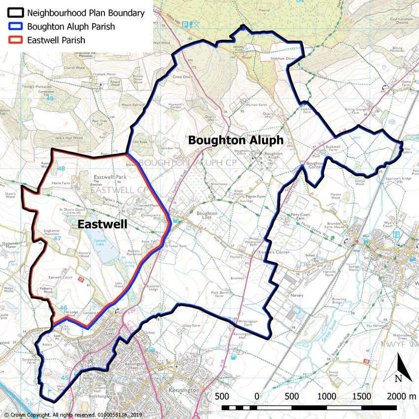
Contents

Acknowledgements                                                                                 3

Section 1: Introduction                                                                          4

Section 2: Boughton Aluph and Eastwell Parishes Now                                             10

Section 3: Boughton Aluph and Eastwell Parishes Future: a vision to 2030                        14

Section 4: Boughton Aluph and Eastwell Parishes Neighbourhood Plan Strategy                     14

Section 5: Neighbourhood Plan Policies                                                          17
        Environment                                                                             17
        Housing and Business                                                                    43
        Leisure, Wellbeing and Infrastructure                                                   55

Section 6: Monitoring and Review                                                                63

Appendix 1 - Character Areas Assessments                                                        64

Policy BAE NP1 - Design of New Development and Conservation                                      21
Policy BAE NP2 – Protection of Local Green Space                                                 28
Policy BAE NP3 – Development in the Countryside                                                  41
Policy BAE NP4 – Development beyond the built-up area of Boughton Lees village                   42
Policy BAE NP5 - Eureka Park – Site Requirements                                                 46
Policy BAE NP6 – Small scale residential development within the built-up confines of Boughton Lees
                                                                                                 48
Policy BAE NP7 – Eureka Place Local Centre                                                       53
Policy BAE NP8 - Public Houses                                                                   54
Policy BAE NP9 – Public Rights of Way                                                            58
Policy BAE NP10 - Retention of Community Buildings                                               60
Policy BAE NP11 - Securing Infrastructure                                                        62

                                                 2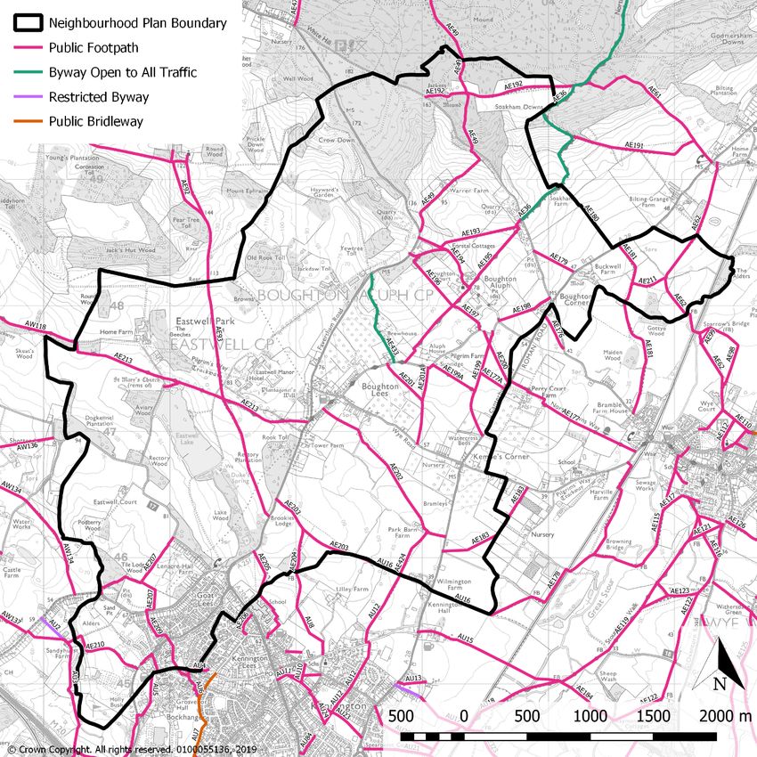
Acknowledgements

This document has been developed and produced by Boughton Aluph and Eastwell Parish
Council in close cooperation with local community volunteers on behalf of the Parish
community.

The team would like to thank the following in preparation of the documents:

   •   The community groups, local societies and school in the Parish for providing support
       and comment throughout the process;
   •   The late Derek Anthony, former Parish Councillor and Chair of Boughton Aluph and
       Eastwell Parish Council who initiated the Neighbourhood Plan project;
   •   Alan Vaughan, Chair of the Boughton Aluph and Eastwell Residents’ Association and
       the BAERA Committee;
   •   Borough Councillor Winston Michael;
   •   Jason Matthews, former Chair of Boughton Aluph & Eastwell Parish Council, and
   •   Tony Fullwood of Tony Fullwood Associates - Chartered Town Planners, who was
       our professional planning consultant.

The Parish Council and the Neighbourhood Plan Steering Group would like to thank the
whole community for participating in the process and for coming together and supporting the
Neighbourhood Plan over its development.

                                             3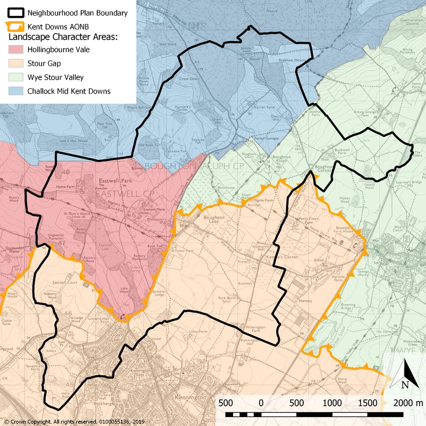
Section 1: Introduction

The Boughton Aluph and Eastwell Parishes Neighbourhood Plan is a new type of planning
document produced in the Parishes. It is part of the Government’s approach to planning
which aims to give local people more say about what goes on in their area. This is set out in
the Localism Act that came into force in April 2012.
If passed at a local referendum, the Neighbourhood Plan will be adopted by Ashford
Borough Council as the plan which must be used in law to determine planning applications in
Boughton Aluph and Eastwell Parishes. It will become part of the Development Plan
alongside the Borough Council’s Local Plan.
The Plan therefore provides the local community with a powerful tool to guide the long-term
future of the Parishes for the period 2013 - 2030. The Plan contains a vision for the future of
Boughton Aluph and Eastwell Parishes and sets out clear planning policies to realise this
vision.
In order to develop the Neighbourhood Plan, Boughton Aluph and Eastwell Parish Council
set up a Neighbourhood Plan Steering Group which comprises 2 Parish Councillors
supported by a number of local volunteers1.
Some of the Neighbourhood Plan policies are general and apply throughout the Plan area,
whilst others are site or area specific and apply only to the relevant areas illustrated on the
associated Map. Nevertheless, in considering proposals for development, the Parish and
Borough Council will apply all relevant policies of the Plan. It is therefore assumed that the
Plan will be read as a whole and cross-referencing between Plan policies has been
minimised.
The Plan should also be read in conjunction with the National Planning Policy Framework,
2019 (NPPF), Ashford Borough Council’s Local Plan 2030 and the Neighbourhood Plan
evidence documents.

1   Past and present members of the Neighbourhood Steering Group are listed here:

      •   Carol Bunker
      •   Ray Burrough
      •   Bryan Hall
      •   Jane Hall
      •   Anna Kirke
      •   Erica Lasparini OBE
      •   Fiona Miller
      •   Bob Morgan
      •   Nigel Bunker
      •   Spencer Phillips

                                                  4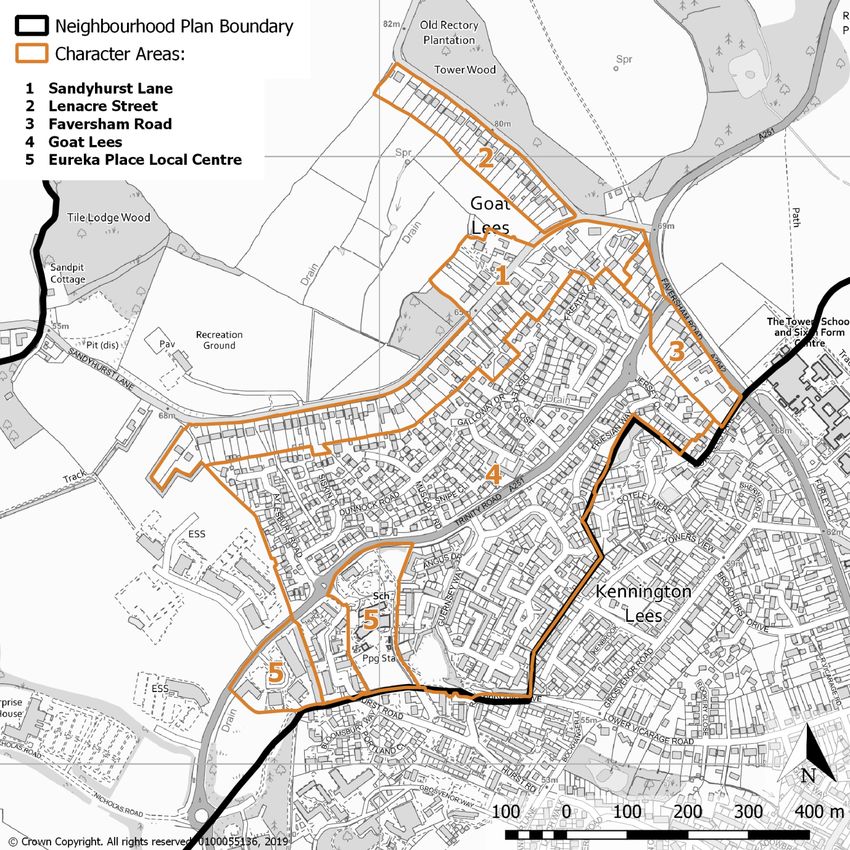
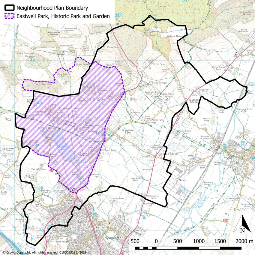
Which Area Does the Neighbourhood Plan Cover?

The Boughton Aluph and Eastwell Parishes Neighbourhood Plan relates to the designated
area covered by Boughton Aluph and Eastwell Parish Council. The neighbourhood plan
designation was approved by Ashford Borough Council on 12 June 2014. The area to which
the Plan applies is shown on the Boughton Aluph and Eastwell Parishes Neighbourhood
Plan Designation Map (Map 1).

Map 1 - Boughton Aluph and Eastwell Parishes Neighbourhood Plan Area

                                              5
Involvement in the Neighbourhood Plan Process

The Neighbourhood Plan team has followed the necessary legal steps to create the Plan.
Importantly the team has ensured engagement with the people of both Boughton Aluph and
Eastwell Parish and others with an interest in the area.

Details of engagement and consultation are recorded in the Consultation Statement which is
available to download from the Boughton Aluph and Eastwell Parish Council website.

The process is set out in Figure 1 below with the opportunities for local involvement
highlighted in dark green.
The Plan incorporates those modifications required by the independent Examiner to allow
the Plan to go to referendum. This gives the local electorate the power over whether they
want their Plan to be used in local decisions.

                                              6
Figure 1 – Boughton Aluph and Eastwell Parishes Neighbourhood Plan Process

        April 2012              Neighbourhood Planning Regulations published

       12 June 2014          Boughton Aluph and Eastwell Parishes Neighbourhood
                                              Plan designation

        September
                            4 'discovery' events; household survey and 3 post survey
        2015 - July
           2016                                       events

                                 Data and evidence collection and interpretation
       2014 - 2018
                                        and drafting of Neighbourhood Plan

                            Draft Neighbourhood Plan Pre-Submission consultation -
       Spring 2019              testing proposals for the future development of
                                     Boughton Aluph and Eastwell Parishes

      Summer 2019             Review consultation; further evidence gathering, Plan
         onwards                         amendment and finalisation

      Autumn 2020                         Submission consultation 6 weeks

       Winter 2020          Examination - An Independent Examiner will test the Plan

      Summer 2021                                    Referendum

                              Adoption - Plan given full weight by ABC to determine
      Summer 2021
                                planning applications if approved at referendum

                                              7
How the Neighbourhood Plan fits into the planning system

Although the Government’s intention is for local people to decide what goes on in their area,
all Neighbourhood Plans must be in line with higher level planning policy. That is, within the
constraints imposed by national guidance and local policy, neighbourhoods should develop
a shared vision for their area and develop plans that support the strategic development
needs set out in Local Plans. Neighbourhood Plans should not promote less development
than set out in the strategic policies for the area, or undermine those strategic policies.
Neighbourhood Plans must comply with European Regulations on strategic environmental
assessments and habitats, and with the NPPF, and they must generally conform with the
strategic policies in the adopted Ashford Local Plan 2030.
Nevertheless, if passed at a local referendum, the Neighbourhood Plan will be adopted by
Ashford Borough Council as the plan which must be used in law to determine planning
applications in Boughton Aluph and Eastwell Parishes.

What is in the Neighbourhood Plan?

The Plan is for Boughton Aluph and Eastwell Parishes as a whole and looks at a wide range
of issues, including:
     • Protecting the distinctive character of the built-up area; recognising the intrinsic
        character and beauty of the surrounding countryside; conserving and enhancing the
        Kent Downs Area of Outstanding Natural Beauty and achieving high quality
        development which fits well with the location;
     • Retaining the Local Green Spaces important to local heritage, amenity, recreation
        and/or wildlife;
     • Protecting important public views;
     • Carefully assimilating high quality housing and business development at the strategic
        Eureka site in a parkland setting;
     • Enabling local people to stay in or return to the Parishes by ensuring a supply of
        affordable housing; and
     • Protecting and enhancing Eureka Place Local Centre; community buildings;
        recreation open space and the network of local footpaths.

What period does the Neighbourhood Plan cover?

The Boughton Aluph and Eastwell Parishes Neighbourhood Plan covers the Plan period
from 2013 – 2030 to coincide with the period for the Ashford Local Plan 2030.

Strategic Environmental Assessment and Habitat Regulations Assessment

A Strategic Environmental Assessment (SEA) is required under European legislation for all
plans which may have a significant effect on the environment. To determine whether the
Boughton Aluph and Eastwell Parishes Neighbourhood Plan requires a SEA it is necessary
to screen the proposals in the plan to determine whether it is likely to result in significant
environmental effects.

                                               8
Ashford Borough Council is legally required to determine whether a neighbourhood plan will
require SEA. As part of this screening process it is necessary to consult the SEA
consultation bodies (Historic England, Natural England and the Environment Agency) to get
their opinion on whether or not the plan is likely to result in significant environmental effects
and therefore whether a SEA is required.
The Screening Report for the Neighbourhood Plan finds no significant negative effects will
occur as a result of the Plan and it is concluded that a full SEA is not required at this time.
The Habitats Regulations Assessment (HRA) refers to the appropriate assessment required
for any plan to assess the potential implications for European wildlife sites. The first stage of
the HRA process is a screening exercise undertaken by Ashford Borough Council where the
details of nearby internationally designated sites are examined to assess whether there is
the potential for the implementation of the Plan to have an impact on the sites. Following
such an assessment, it is considered that the Boughton Aluph and Eastwell Parishes
Neighbourhood Plan proposals will not adversely affect the integrity of the internationally
designated sites, alone or in combination with other projects and plans. It is therefore
considered that a full HRA of the Boughton Aluph and Eastwell Parishes Neighbourhood
Plan is not required.

How this Plan is organised

The Plan is divided into the following sections:
Section 2:   Boughton Aluph and Eastwell Parishes Now: a brief description of the
             Parishes today and the key issues that have influenced the Plan
Section 3:   The Vision for Boughton Aluph and Eastwell Parishes: a long-term vision
             for the Parish up to 2030
Section 4:   Boughton Aluph and Eastwell Parishes Neighbourhood Plan Strategy: the
             broad planning approach for the Parishes and how this conforms with higher
             level planning policy
Section 5:   Neighbourhood Plan Policies: sets out policies to support the overall vision,
             including site specific allocations for new development. Policies are arranged in
             the following themes:
                 •   Environment
                 •   Housing and Business
                 •   Leisure, Wellbeing and Infrastructure
Section 6:   Monitoring and Review: which explains how the Neighbourhood Plan will be
             monitored and the circumstances which may lead to a review of the plan.

                                                9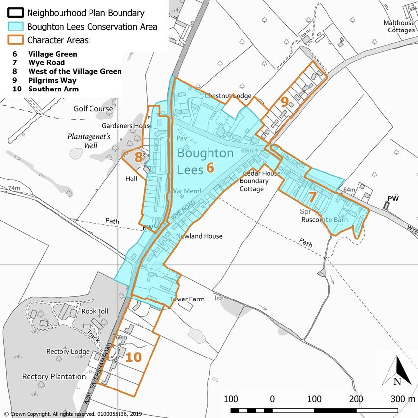
Section 2: Boughton Aluph and Eastwell Parishes Now

The earliest part of the Parishes has its origins in a Roman road junction, where the route
linking the Weald to Canterbury crossed the road running from Dover to Faversham and
Reculver (remains can be seen at Kempe’s Corner). The ancient Pilgrims’ Way to
Canterbury doglegs through the middle of the Parishes, with a branch dividing off from the
eastern end of Boughton Lees towards Folkestone and Dover.
Settlement in both Boughton Aluph and Eastwell dates back to Saxon times, and they
feature in the Domesday Book of 1086. The gradual growth and increasing significance of
Eastwell Park Estate, especially in the nineteenth century, led to additional housing for
estate workers and trades (including blacksmith, wheelwright, butcher and grocer) in
Boughton Lees around a triangular green. In this way the village grew around the green
rather than by the two churches of St Mary the Virgin Church, Eastwell, and the pilgrim`s
church of All Saints at Boughton Aluph.
In more recent times, Ashford has expanded into the southern tip of the Parishes. Between
the 1991 and 2001 censuses the population rose from 695 to 1099. More strikingly still the
2011 census shows the Parishes recording the highest percentage population increase in
Kent, 126%, from 1099 to 2490 persons.
Today around 90% of the Boughton Aluph and Eastwell Parishes population reside within
the Ashford urban area with the remaining 10% residing in Boughton Lees and smaller
hamlets within the rural part of the Parishes. Conversely, the Parishes area is predominantly
rural with approximately 75% countryside with the remaining 25% to the south west of the
Parish being a well-developed, residential and employment suburb of Ashford – the
Eureka/Goat Lees area.
A wide range of issues have been considered in producing the Neighbourhood Plan. These
are grouped under three themes:
                 •   Environment
                 •   Housing and Business
                 •   Leisure, Wellbeing and Infrastructure
The key issues for these themes are set out below. The main issues have been identified
from research along with issues raised by local people at the various consultation events.
The background reports used to help prepare the Neighbourhood Plan are referred to in
more detail in Section 5.

Environment
More than half of the Plan area is situated within the Kent Downs Area of Outstanding
Natural Beauty (AONB) which skirts the northern and western edges of Boughton Lees and
extends north-east and south-west to include the hamlets of Boughton Aluph and Eastwell.
The remaining areas of countryside have a distinctive character and provide the setting for
the AONB. There are dramatic panoramic views across open arable land of the North
Downs, including from Ashford and Boughton Lees. One of the distinctive features which
results from the topography and layout of development is the strong visual connectivity

                                             10
between both Ashford and Boughton Lees and the landscape – offering long and shorter
distance views from the built-up area.
The extensive and picturesque Eastwell Park, a Historic Park and Garden in Kent, extends
between the edge of Ashford and Boughton Lees and is located within the AONB.
Areas of ancient woodland, poplar shelter belts and remnant hedgerows add to the
landscape character and biodiversity of the area.
Boughton Aluph Parish incorporates the northern edge of Ashford and part of the extensive
Eureka Park housing and business park allocation. The area of Ashford within the Parish
Council area incorporates five distinctive areas, each with a different character. The adopted
Local Plan allocates a strategic site at Eureka Park for a mix of commercial and housing
development.
The historic centre of Boughton Lees is designated as a Conservation Area for its special
architectural and historic character and the village comprises six distinctive character areas.
Historic England’s register shows a number of listed heritage assets in the Parishes.
Without careful planning, the distinctive character and sensitive landscape and ecology are
under threat from significant and inappropriately located or designed development. The
landscape forms a setting which contributes to the attraction of Ashford, Boughton Lees and
the hamlets as places to live and work, and plays a vital role in maintaining the health and
wellbeing of the population.
Housing and Business
The 2011 census tells us that in 2011 Boughton Aluph and Eastwell Parishes had 1,337
dwellings located primarily within the Goat Lees area of Ashford. There is a predominance of
family housing (45% of homes having 3 bedrooms or more). 64.7% of homes are owned,
with 13.3% available for social rent, 17.6% private rent and 1.6% shared ownership.
Between 2001 and 2011 some 540 dwellings were added to the housing stock of the
Neighbourhood Plan area, primarily in the Goat Lees area which was completed 20 years
ago.
The NPPF, 2019 states that to support the Government’s objective of significantly boosting
the supply of homes it is important that a sufficient amount and variety of land can come
forward where it is needed. In addition, significant weight should be placed on the need to
support economic growth and productivity, taking into account both local business needs
and wider opportunities for development. Neighbourhood Plans should not promote less
development than set out in the strategic policies for the area, or undermine those strategic
policies.
The adopted Ashford Local Plan 2030, allocates an area for a mix of commercial (around
20ha) and residential development (indicative capacity of 375 dwellings). That part of this
strategic development which is located within the Parishes is supported in the
Neighbourhood Plan. In accordance with the NPPF (Para. 21), the Neighbourhood Plan
contains further development principles for this site.
The number of dwellings already completed within the Neighbourhood Plan area since the
start of the plan period (2013) is 5 and a further 7 dwellings are committed through planning
permissions. With further windfalls and potentially some of the 375 dwellings from the
11Eureka site located in the Plan area, the Parishes are anticipating much slower housing
growth following the significant change over the past 20 years.
There are established B1 uses at Eureka Park Business Park originally designated as a key
strategic employment area with high quality buildings within a parkland and wetland setting.
The area provides a different type of offer to the other business locations in Ashford with
lower density development able to be incorporated within a landscaped setting - and it is
important that this type of provision continues to be accommodated. However, it is possible
that other uses beyond B1 office developments, such as health care facilities or similar high-
quality services, could complement the wider B1 office elements of the site.
The facilities and services at Eureka Place Local Centre together with the hotels; self-
catering and bed and breakfast accommodation located in the area, provide further diversity
in local employment opportunities.
The Parish Council considers that a Neighbourhood Plan should be in place to help guide
and coordinate the future development of the Parishes. Residents are keen to ensure that
development is absorbed within the environmental constraints identified and can be
supported by sufficient infrastructure to ensure the quality of life of existing and future
residents.
When planning new development, it is important to understand the characteristics of each
distinct area of Ashford and Boughton Lees and designs should respond to the distinctive
local character.
Leisure, Wellbeing and Infrastructure
The focus of the Parishes population at the edge of the Ashford urban area means that most
of the facilities and services in the Neighbourhood Plan area are concentrated in the Goat
Lees area - clustered within the Eureka Place Local Centre. The primary school, shops, a
public house, cafes/ restaurants, medical facilities, dental practice and a community hall are
all found at the Local Centre which provides a focus for the area and an important
opportunity for social interaction whilst enabling more sustainable linked trips to a variety of
services.
Goat Lees Primary School opened in 2013 but is at capacity. The Eureka Park residential
development could generate a need for approximately 105 primary school places and the
only primary school within walking distance is Goat Lees. Kent County Council indicates that
St. Theresa Primary School in Ashford town centre will be able to expand and that other
primary schools are being planned. However, these are at some distance from the Eureka
site and beyond walking distance. The lack of primary school places locally will increase the
number of vehicle trips at peak time on the local roads.
There is no secondary school located within the Parishes, although Towers Secondary
School abuts the Neighbourhood Plan boundary and two grammar schools are located in
Ashford town centre.
There are no GP surgeries located in the Parishes with the closest found in Wye or Bybrook,
Ashford.
The Parishes are served by three community halls: Goat Lees Community Hall (within the
Eureka Place Local Centre); Sandyacres Sports and Social Club (which serves as a sporting
hub) and the Iron Room, Boughton Lees.
12Of the two public houses found in the Parishes, one is located within Eureka Place Local
Centre - The Pheasant; the other adjoining the Green at Boughton Lees -The Flying Horse
Inn.
In terms of outdoor sports pitches, Sandyacres Sports and Social Recreation Open Space,
Sandyhurst Lane, provides football and rugby pitches as well as tennis courts (which are out
of use). The Boughton Lees village green has seen cricket played there for over 200 years.
An informal playing area with a football goalpost is located between Guernsey Way and
Rothbrook Drive, Goat Lees, although this is subject to flooding during winter months. A
Youth Play Space is provided at Trinity Road, Goat Lees. An extensive network of footpaths,
cycle paths and bridleways cross the Parishes and are widely used and valued by residents.
The Goat Lees development abuts the Kennington area to the north and west and the
Eureka leisure complex and Ashford Golf Course to the south. As a consequence,
community facilities and services are used by many people from outside of the Parishes.
Similarly, Parish residents utilise service and leisure facilities outside the Parishes,
particularly within the Ashford urban area e.g. the cinema and restaurant/fast food outlet at
Eureka is in close proximity to the Neighbourhood Plan boundary. Wye village centre also
offers facilities such as restaurants, pubs, schools, medical and sporting facilities that are
utilised by Parish residents.
13Section 3: Boughton Aluph and Eastwell Parishes Future:
a vision to 2030
Our vision is for Boughton Aluph and Eastwell Parishes to retain its distinctive rural character
at the urban edge of Ashford, surrounding the village of Boughton Lees and within the
hamlets of Boughton Aluph, Eastwell and Kempe’s Corner by carefully integrating the
Eureka Park expansion of Ashford into the local landscape (including the setting of the Kent
Downs Area of Outstanding Natural Beauty) and successfully interweaving high quality new
development into the Goat Lees area of Ashford and the historic fabric of Boughton Lees.
The Parishes will continue to be served by enhanced key local services and public open
space.
Section 4: Boughton Aluph and Eastwell Parishes
Neighbourhood Plan Strategy
Boughton Aluph and Eastwell Parishes need to continue to evolve and the Neighbourhood
Plan looks to set out a planning strategy appropriate for the expansion of Ashford at Eureka
Park and small scale development within Boughton Lees whilst protecting valued
landscapes (including the highly valued Kent Downs Area of Outstanding Beauty, Eastwell
Historic Park and Garden, ancient woodland and public footpaths and bridleways), local
green spaces and important local views.
All plans should be based on, and reflect, the presumption in favour of sustainable
development, and take account of the NPPF with clear policies that will guide how the
presumption should be applied locally. The national planning policy background to each of
the Neighbourhood Plan topics is set out in the relevant sections of the Plan. The
Neighbourhood Plan must be in general conformity with the strategic policies of the adopted
Local Plan and should support the strategic development needs set out in the Local Plan. To
facilitate this, local planning authorities should set out clearly their strategic policies for the
area. The Neighbourhood Plan should reflect these policies and should plan positively to
support them. The Neighbourhood Plan should not promote less development than set out in
the Local Plan or undermine its strategic policies.
The Neighbourhood Plan strategy is well aligned with the presumption in favour of
sustainable development contained in the NPPF. The Plan positively supports the strategic
allocation for housing and commercial development at Eureka Park and recognises specific
policies in the NPPF. These indicate where development should be restricted and seek to
minimise any adverse impacts which development may cause to the locally valued
distinctive characteristics of the area.
Recognising the strategic Local Plan allocation at Eureka Park for housing and commercial
development, the planning strategy is to focus well designed development in a parkland
14setting at Eureka Park - providing the necessary transport, community and open space
infrastructure to ensure the quality of life of existing and future residents of the Parishes.
The built-up confines of Boughton Lees are defined (see Map 2 below) and the
Neighbourhood Plan seeks to enable small scale residential development opportunities
within the village whilst protecting its rural setting and the surrounding countryside from
inappropriate development.
Map 2 – The built-up confines of the village of Boughton Lees
Hamlets such as Boughton Aluph; Eastwell and Kempe’s Corner are not sustainable places
for new housing development and both Boughton Aluph and Eastwell are situated within the
Kent Downs AONB.
Local Green Spaces and Important Public Views are identified and to be protected.
Affordable housing will be provided through adopted Local Plan policies within the Eureka
development or an exception site at the edge of Boughton Lees if housing need can be
demonstrated in the village.
15The Plan seeks high quality designs which respond to the distinct character of the individual
areas of Goat Lees and Boughton Lees and will preserve and enhance the character and
setting of the Boughton Lees Conservation Area.
The Neighbourhood Plan recognises the important community networks in Goat Lees and
Boughton Lees and seeks to protect and enhance the social and economic hub of the
Eureka Place Local Centre together with other community and leisure facilities which are
important to the social fabric of the Parishes.
16Section 5: Neighbourhood Plan Policies
Environment
Objectives
• To protect the character of the landscape and conserve and enhance the natural
beauty of the Area of Outstanding Natural Beauty which provides the setting for
houses at Goat Lees, the village of Boughton Lees and hamlets of Boughton Aluph,
Eastwell and Kempe’s Corner.
• To conserve and enhance the heritage of our Parishes, including the Boughton Lees
Conservation Area.
• To protect Local Green Spaces within the built-up areas of the Parishes.
• To protect distinctive, locally valued views.
• To ensure high quality design in all forms of development which responds to the
distinctive landscape, heritage and character of the Parishes.
Environment Policies
High Quality Design
The NPPF states that the creation of high-quality buildings and places is fundamental to
what the planning and development process should achieve. Good design is a key aspect of
sustainable development, creates better places in which to live and work and helps make
development acceptable to communities. Plans should set out a clear design vision and
expectations, so that applicants have as much certainty as possible about what is likely to be
acceptable. Design policies should be developed with local communities, so they reflect local
aspirations, and are grounded in an understanding and evaluation of each area’s defining
characteristics. The NPPF confirms that neighbourhood plans can play an important role in
identifying the special qualities of each area and explaining how this should be reflected in
development.
Distinctive Character Areas
The Ashford Local Plan 2030, Policy SP6 - Promoting High Quality Design attaches great
importance to the quality of design in new development including demonstrating a positive
response to character, distinctiveness and sense of place.
The ‘character of an area’ is often mentioned in the context of considering development
proposals. What is often missing is a clear identification of, and agreement about, the locally
distinctive features of an area that give it character that should be given careful regard in
considering proposals for development. The Neighbourhood Plan can play an important role
in identifying the special character of each area and explaining how this should be reflected
in the designs of proposed development. For this purpose, the Neighbourhood Plan
identifies five areas of distinctive character within the south west of Boughton Aluph Parish
(including Goat Lees) (see Map 3 below) and a further six areas of distinctive character at
Boughton Lees (see Map 4 below).
17Through evaluation, there is a good understanding of the distinctive characteristics of each
of the character areas. Buildings of Note are also identified where the use, mass, scale,
design or visual prominence of a building mean that it plays an important role in the
character of an area. Whilst many Buildings of Note are listed buildings, others are not, but
the Neighbourhood Plan would seek to protect all such buildings.
Generally, the Character Areas are in good condition but a limited number of features which
detract from the character have been noted.
Appendix 1 of the Neighbourhood Plan sets out the distinctive character; Buildings of Note
and detractors for each separate character area within the south west of Boughton Aluph
Parish (including Goat Lees) and Boughton Lees.
Map 3 - South West of Boughton Aluph Parish (including Goat Lees) Character Areas
18Map 4 below shows the position of the 6 Character Areas in Boughton Lees in relation to the
boundary of the Boughton Lees Conservation Area which is shaded blue.
Map 4 - Boughton Lees Character Areas and Conservation Area
Heritage
The historic centre of Boughton Lees is designated as a Conservation Area as shown on
Map 4 above. The Conservation Area is made up of areas of different character. The
Planning (Listed Buildings and Conservation Areas) Act 1990 empowers the local authority
to pay particular attention to proposed development within, and affecting the setting of, a
Conservation Area and gives greater control over such matters as demolition, landscaping
and trees, and the display of advertisements. In the absence of a Conservation Area
Appraisal and Management Plan for the Conservation Area, the special character of these
designated areas can be derived from Appendix 1.
The NPPF also seeks the protection of the character and setting of listed buildings and
Conservation Areas. Historic England’s register shows 39 listed heritage assets in the
19Parishes, of which 36 are buildings (the others are a wall, a milestone and a burial mound -
Long Barrow, Jacketts Field - which is a scheduled monument estimated to be 5,000 years
old).
The extensive Eastwell Park which extends beyond the Plan area is designated a Historic
Park and Garden in Kent. It is made up of part of the farmed estate and Eastwell Manor and
grounds. The principal building was constructed between 1793 and 1799 and demolished in
1926. Only the gatehouse and Eastwell towers of the original buildings remain, with a new
house constructed on the site between 1926 and 1928 by Sir John Pennefather.
Map 5 - Eastwell Park, Historic Park and Garden in Kent
In addition, there are areas known to be of archaeological interest and areas with
archaeological potential around Boughton Aluph; within Eastwell Park and Kings Wood and
around the long barrow to the west.
These designated and undesignated heritage assets provide an important context for new
development.
20Landscape
The northern and western part of the Plan area is situated within the Kent Downs Area of
Outstanding Natural Beauty (AONB) - see Map 14 below.
The remaining areas of countryside have a distinctive character and provide the setting for
the AONB. There are dramatic panoramic views across open arable land of the North
Downs, including from Ashford and Boughton Lees.
The NPPF states that great weight should be given to conserving the landscape and scenic
beauty of Areas of Outstanding Natural Beauty, which have the highest status of protection.
The AONB Management Plan seeks to ensure that the natural beauty, special character and
the vitality of its communities are recognised, maintained and strengthened.
Without careful planning, the distinctive character and sensitive landscape would be under
threat from development of an inappropriate scale, location or design. Any development
must be well integrated into the landscape for example through the use of existing and new
landscape buffers.
Policy BAE NP1 - Design of New Development and Conservation
New development in accordance with the Neighbourhood Plan will be supported where it:
a) Is designed to a high quality which responds to the heritage and distinctive characteristics
of the individual area in which it is located within the south west of Boughton Aluph Parish
(including Goat Lees) and Boughton Lees, as defined in Appendix 1, by way of:
i. height, form, layout, orientation, materials, fenestration and boundary treatment;
ii. the scale, design and materials of the public realm (highways, footways, open space
and landscape);
b) Protects and enhances heritage assets and their setting (including the following Buildings
of Note as set out in Appendix 1);
• Lenacre Hall Farmhouse, Sandyhurst Lane
• Eastwell Towers, Eastwell Park, Faversham Road
• Stone House, Faversham Road
• Goat Lees Primary School, Hurst Road
• The Flying Horse Inn, Wye Road
• Eastwell Terrace, Wye Road
• St Christopher’s Church, Faversham Road
• Gardeners House, Faversham Road
c) Protects and sensitively incorporates landscape features such as trees, hedges and
ponds within the site; and
d) Is well integrated into the landscape.
Development proposals affecting non-designated heritage assets, either directly or indirectly,
should respect the significance of the local context of the asset as well as the positive
contribution that the heritage asset makes to local character and distinctiveness.
21Monitoring Indicators Targets
Number of applications to which Parish No applications to which Parish Council have
Council have objections to the design of objections to the design of development.
development.
Areas of Local Green Space
Responses to community consultation including the Neighbourhood Plan household survey
identified important open spaces within the Parishes.
Green space at junction of Trinity Road and Jersey Close/Friesian Way, Goat Lees
Public open spaces within, and close to, the built-up areas of Goat Lees and Boughton Lees
are important to local amenity, the heritage and/or character of the area as well as providing
opportunities for leisure and wildlife in the Parishes and are to be protected in the
Neighbourhood Plan.
St Mary the Virgin Churchyard, Eastwell
Away from the built-up areas there are two local green spaces at the hamlets of Boughton
Aluph and Eastwell which provide the setting for listed churches as well as tranquil informal
recreation spaces and these are also to be protected in the Neighbourhood Plan.
Through Neighbourhood Plans, local communities are able to identify for special protection
green areas of particular importance to them.
The location and importance of open spaces within the Parishes has been summarised in
the Local Green Space Assessment, 2018. All Local Green Spaces are relatively small but,
being within or close to areas of Goat Lees; Boughton Lees, Boughton Aluph and Eastwell,
all are in close proximity to the communities they serve.
22The areas are important for a number of sometimes overlapping reasons which are outlined
below:
Open Spaces of Historic Importance
The relationship of buildings and village green is important in creating the special character
of Boughton Lees Conservation Area. In other cases, the local green space is important to
the setting of listed buildings at All Saints Churchyard, Church Lane, Boughton Aluph; St
Mary the Virgin Churchyard, Eastwell and in front of Tower Lodge and adjoining flint wall,
Eastwell Park Estate, at the Sandyhurst Lane/ A251 Faversham Road junction.
Open Spaces Contributing to the character of an area
Open spaces can play an important role in creating the distinctive character of an area which
is not designated as a heritage asset.
Open Space of Local Visual Amenity Value
A number of open spaces within the built-up confines provide important visual amenity.
Recreational Value
Most open spaces act as informal or formal recreational amenity space to the adjoining
residential development. The churchyards provide more tranquil spaces with St Mary the
Virgin Churchyard beside Eastwell Lake.
Wildlife Value
All Saints and St Mary the Virgin Churchyards contain wildlife interest on the gravestones
and through ancient trees and surrounding vegetation.
The sites are listed below, and their location is identified on Maps 6 - 12 below.
LGS Ref No.
Local Green Space Description
1 The Village Green, Boughton Lees
2 All Saints Churchyard, Church Lane, Boughton Aluph
3 St Mary the Virgin Churchyard, Eastwell
Green space in front of Eastwell Towers and adjoining flint wall at
4
junction of Sandyhurst Lane and A251 Faversham Road
5 Children’s play area and amenity space, Hurst Road, Goat Lees
6 Green space and informal recreational area, Guernsey Way, Goat Lees
Green space at junction of A251 Trinity Road, Jersey Close and
7
Friesian Way, Goat Lees
Three of the spaces provide a cricket pitch, an informal football pitch and a sports and social
recreation open space respectively whilst another is a children’s play space. Provision of
appropriate built facilities in connection with the use of land for outdoor sport and outdoor
23recreation would be appropriate within the Local Green Space provided this would not be in
conflict with retaining the open green character of the designated space.
Map 6 - Village Green, Boughton Lees (LGS1)
24Map 7 - All Saints Churchyard, Boughton Aluph (LGS2)
Map 8 - St Mary the Virgin Churchyard, Eastwell (LGS3)
25Map 9 - Green space in front of Eastwell Towers (LGS4)
Map 10 - Children’s Play Area and amenity space, Trinity Road, Goat Lees (LGS5)
26Map 11 - Green space and informal recreational area, Guernsey Way, Goat Lees (LGS6)
Map 12 - Green space at junction of A251 Trinity Road, Jersey Close and Friesian Way, Goat Lees
(LGS7
27Policy BAE NP2 – Protection of Local Green Space
Sites are designated as Local Green Spaces as defined on Maps 6-12.
Proposals for development at the sites identified on Maps 6-12 as designated Local Green
Spaces will be considered in line with national planning policy on Green Belts.
28The Countryside
Boughton Aluph and Eastwell Parishes lie on land sloping, initially steeply, from the top of
the North Downs towards the Great Stour Valley. A long-established tradition of mixed
farming has helped create the natural beauty of the Kent Downs and its setting.
Monitoring Indicators Targets
Local Green Spaces lost. All Local Green Spaces retained.
Kent Downs Area of Outstanding Natural Beauty
The northern and western parts of the Plan area are situated within the Kent Downs Area of
Outstanding Natural Beauty (AONB), with the boundary encircling the south-western and
south western edge of Boughton Lees (see Map 13). The Kent Downs AONB Landscape
Assessment, 1995, prepared by the Countryside Commission, defined a number of distinct
character areas within the AONB (see also Map 13).
The Kent Downs AONB Management Plan sets out the special characteristics and qualities
of the Kent Downs AONB and formulates the local policies for its management by the 12
local authorities within the Kent Downs. Although the Management Plan does not form part
of the statutory development plan, it is a material consideration that should be taken into
account when preparing Neighbourhood Plans as well as determining planning applications.
The NPPF states that great weight should be given to conserving and enhancing landscape
and scenic beauty in Areas of Outstanding Natural Beauty which have the highest status of
protection in relation to landscape and scenic beauty. The conservation of wildlife and
cultural heritage are important considerations in these areas.
Setting of the Kent Downs AONB
The setting of the Kent Downs AONB is broadly speaking the land outside the designated
area which is visible from the AONB and from which the AONB can be seen, but may be
wider when affected by intrusive features beyond that. There are extensive views across
open arable land of the North Downs, including from Ashford and Boughton Lees. The
setting is not formally defined or indicated on a map. Proposals which would affect the
setting of the AONB are not subject to the same level of constraint as those which would
29affect the AONB itself. The weight to be afforded to setting issues will depend on the
significance of the impact. Where the qualities of the AONB which were instrumental in
reasons for its designation are affected, then the impacts should be given considerable
weight in decisions. This particularly applies to views to and from the scarp of the North
Downs.
The adopted Landscape Character Supplementary Planning Document (based on the Studio
Engleback study, 2005) sub-divides the landscape character areas between Ashford and the
AONB into district landscape types around the edge of Ashford (see also Map 13).
Sandyhurst Lane forms a well-defined edge to the Ashford urban area and provides
separation between the built form which forms the edge of the settlement of Ashford on one
side and open countryside on the other. Lenacre Hall and nearby buildings are located on
the north side of the road, but these buildings are limited in number and the rural area to the
north provides an attractive and clearly defined setting to Ashford in this location.
Sandyhurst Lane
30Map 13 - Kent Downs AONB and Landscape Character Areas. The Neighbourhood Plan boundary is
shown in black.
Landscape Character Areas
Hollingbourne Vale
The area to the west of Boughton Lees comprises the Hollingbourne Vale landscape
character area: a rolling landscape of mixed farmland overlooked by yew-dominated scarp
with thick hedges along Pilgrims’ Way long distance footpath which runs through this area.
The area contains Eastwell Park Estate part of which is designated as a Historic Park and
Garden in Kent. The extensive and picturesque park contains many grand trees and a large
lake. The character area lies within the Kent Downs AONB.
31Hollingbourne Vale - Farmland of Eastwell Park Estate
Hollingbourne Vale - Eastwell Lake
Wye Stour Valley
The area to the north-east of Boughton Lees, the Wye Stour Valley landscape character
area, comprises small fields with hedgerows and small plantation woodlands with
characteristic historic buildings and the hamlet of Boughton Aluph. Pilgrims’ Way also
passes through this area. The character area lies within the Kent Downs AONB.
32Wye Stour Valley - view across Stour Gap
Wye Stour Valley - View towards hamlet of Boughton Aluph
Challock Mid Kent Downs
To the north of the Plan area the Challock Mid Kent Downs landscape character area
comprises a unified landscape with a coherent pattern of landform and elements and few
detracting features. Woodlands, including Kings Wood, occur in large blocks and there is
much single-age plantation. The character area lies within the Kent Downs AONB.
33View across Warren Farm Kings Wood
Stour Gap
This landscape character area forms a sloping landscape towards the Great Stour River and
comprises large arable fields and horticultural areas of fruit orchards and small pine
plantations, enclosed by continuous and remnant hedges and hedgerow trees with some
discrete woodland blocks and tall poplar shelter belts. The area provides extensive,
sometimes panoramic, views to the North Downs.
Eastwell Farmlands
The Ashford Landscape Character Study, 2005 identifies a number of landscape character
areas. The study sub-divides the landscape character areas into district landscape types.
This is in order to provide a more detailed analysis and description of the smaller land units
on the edge of the urban area. Within the Stour Gap, the Landscape Character
Supplementary Planning Document identifies the Eastwell Farmlands as a district landscape
type situated between this urban edge and the North Downs. The area comprises rolling
arable and pasture land with medium sized fields generally divided by mature thick hedges
(which have in places disappeared leaving remnant mature oaks) and the Studio Engleback
study recommends conserving the landscape and creating hedgerow and woodland
enhancements. Outside the Kent Downs AONB, this is the only part of the landscape within
the Plan area for which the Study recommends conserving and creating the landscape
(specifically through woodland planting and hedge reinstatement).
The adopted Landscape Character SPD, 2011 states that there is a need to ensure
development proposals demonstrate regard for the area of landscape within which a
proposal is located. Thus, in the Eastwell Farmlands distinctive character area the emphasis
should be on conserving and creating the landscape.
34This is supported by Ashford Local Plan Policy SP1 - Strategic Objectives provides the core
principles that planning applications are expected to adhere to. Criterion b is:
b) To conserve and enhance the Borough’s natural environment including designated and
undesignated landscapes.
Local Plan Policy ENV3a - Landscape Character and Design states that all proposals for
development in the borough shall demonstrate particular regard to any relevant guidance
given in the Landscape Character SPD and any non-designated, locally identified, significant
landscape features justified in a Parish Plan or equivalent document.
The Eastwell Farmlands area immediately abuts the Kent Downs AONB to the north. The
rolling arable and pasture land with medium sized fields generally divided by mature thick
hedges provides the setting for this part of the AONB.
A recent appeal (APP/E2205/W/19/3220880) confirms that this area of open countryside
provides an attractive setting to the settlement of Ashford in this location.
View of the Eastwell Farmlands from View of the Eastwell Farmlands towards
Sandyhurst Lane Sandyhurst Lane from public footpath AE207
For these reasons, it is appropriate that Policy BAE NP3b seeks only to permit development
which would retain the landscape character of, and not have a detrimental impact on, the
area of Eastwell Farmlands valued landscape defined on Map 14.
In accordance with the NPPF, the Neighbourhood Plan seeks to protect and enhance this
valued landscape as defined on Map 14 below.
35Map 14 - Eastwell Farmlands valued landscape
Ancient Woodland
There are significant tracts of ancient woodland within the Parishes including land abutting,
and north of Sandyhurst Lane; Kings Wood and parts of the Eastwell Park Estate (see Map
15).
The NPPF states that planning permission should be refused for development resulting in
the loss or deterioration of irreplaceable habitats, including ancient woodland and the loss of
aged or veteran trees found outside ancient woodland and that these areas should be
protected. Some ancient woodland may represent the only link with the original post glacial
‘wildwood’ and is more likely to contain vulnerable animal and plant species than any other
habitat. The rich ground flora of ancient woodlands – bluebells, wood anemones, ramsons
and yellow archangel – and the bird song of warblers, nightingale and nightjar are part of the
natural beauty and heritage of the Parishes. Much of the valued woodland wildlife,
36invertebrates, lichens and fungi, are associated with old trees, deadwood or open ground
and are restricted to ancient woods and wood pasture.
King’s Wood is a 1,500-acre coppiced ancient woodland which was once the hunting ground
of King Henry VIII. The woodland provides an extensive habitat for wildlife such as deer,
badgers, owls and foxes.
Map 15 – Ancient Woodland
Important Public Views
It is recognised that there are a significant number of views across the countryside, including
from the numerous public rights of way that cross the area, but it is impossible to list them
all. Rather, it is important to protect and enhance valued landscape through Policy BAE NP3
and the footpaths which allow access to it through Policy BAE NP9. Thus, the focus of the
Important Public Views is those views from the settlements of Ashford and Boughton Lees
which contribute to local character and amenity. This should not be seen as diminishing the
importance of views within the wider countryside.
One of the distinctive features of Boughton Aluph and Eastwell Parishes is the visual
connectivity with the surrounding countryside from the settlements and public footpaths.
Resident surveys undertaken for the Neighbourhood Plan and responses to Ashford
Borough Council consultation on local planning applications have highlighted that residents
37value highly the visual connection between settlements and the surrounding countryside. In
particular, this is a key characteristic of the Boughton Lees Conservation Area where the
generous spacing between buildings and topography enable key views from the village
green to the Kent Downs and beyond. Ashford Local Plan 2030 - Policy ENV14 -
Conservation Areas states that development should not prejudice important views into or out
of the conservation area. The following Important Public Views have been identified where
the Neighbourhood Plan seeks to maintain the distinctive views of the surrounding
countryside.
Ref. Description of view
1 From Sandyhurst Lane adjacent to the entrance to Sandyacres Sports and Social
Recreation Open Space, looking North East across grassland towards Tower
Wood, Lenacre Street, with views over Lenacre ancient woodland.
2 From public footpath AE207 where it enters Lenacre Hall Farm looking South,
views across farmland and the Sandyacres Sports and Recreation Open Space
and over woodland towards The Warren, Hoads Wood and Godinton Park. And
south-easterly towards the Ashford Town skyline.
3 From Sandyhurst Lane, adjacent to Lenacre Hall Farm buildings, looking North
West over the farm gate, view across farmland and Eastwell Park Estate. The
whole view framed by oak trees.
4 From the junction at the end of Sandyhurst Lane with the A251 Faversham
Road looking East – a panoramic view of the North/Wye Downs and the Crown
above Wye.
5 From the start of footpath AE207, Lenacre Street looking north west to Westwell
and the North Downs.
6 From the A251 Faversham Road at the entrance to Eastwell Manor framed by a
gate in the Great Wall, views to the North West along the drive leading to Eastwell
Manor lined with mature trees and bordered on both sides by open fields with the
woodland of Rook Toll/Rectory Plantation to the South West and the roofline of
Eastwell Manor to the North East.
7 From the West side of the village green, Boughton Lees (‘Gasworks Terrace’)
looking South East, panoramic views of the farmland of the Stour Gap, the
Wye/North Downs, the Crown above Wye and across to parts of Ashford above
and between dwellings on The Lees.
8 From the bus stop adjacent to Gardener’s House, Faversham Road, looking West,
view of Eastwell Manor and Gardens, Eastwell Park and the North Downs.
9 From the North side of the village green, Boughton Lees looking North between
Chestnut Lodge and The Flying Horse Inn, Wye Road view across orchards to the
North Downs and King’s Wood.
10 From the North side of the village green, Boughton Lees looking North between
The Flying Horse Inn and Anderida, Wye Road view across orchards of the North
Downs and King’s Wood.
11 From the entrance to footpath AE202 between Pilgrim Cottage and Bumbles
looking East, panoramic views of the farmland of the Stour Gap (including the only
oast house in the Parishes), the Wye/North Downs and the Crown above Wye and
across to parts of Ashford.
12 From the East side of the village green, Boughton Lees looking South East
between Hobday Cottage and 4 Hobday Cottages, view of the farmland of the
Stour Gap, the Wye/North Downs and across to parts of Ashford.
13 From the War Memorial on the village green, Boughton Lees looking North,
panoramic views of the North Downs and King’s Wood above and between the
dwellings (including two listed properties) on Wye Road.
38Map 16 - Important Public Views - South West of Boughton Aluph Parish
39Map 17 - Important Public Views – Boughton Lees
Development in the Countryside
The growth of Ashford will be facilitated by the development of Eureka Park. Sandyhurst
Lane forms a well-defined edge to Ashford and specific further development within the
countryside is not allocated in the Ashford Local Plan 2030 or the Neighbourhood Plan. The
planning strategy is to focus development within the Eureka Park strategic allocation and the
defined built-up confines of Boughton Lees. Any development in the countryside should
comply with the Ashford Local Plan 2030, Policy HOU5 whilst also ensuring it would
conserve and enhance the Kent Downs Area of Outstanding Natural Beauty and its setting;
retain the landscape character of, and not have a detrimental impact on, the area of Eastwell
Farmlands valued landscape shown on Map 15; protect ancient woodland and maintain
important views from public areas. Policy BAE NP2 is also relevant in protecting Local Green
Space.
40Policy BAE NP3 – Development in the Countryside
A proposal for development within the countryside will only be supported where:
a) it would conserve and enhance the landscape and scenic beauty of the Kent Downs Area
of Outstanding Natural Beauty and its setting as well as the tranquillity of the countryside
and would have regard to the Kent Downs AONB Management Plan;
b) it would retain the landscape character of, and not have a detrimental impact on, the area
of Eastwell Farmlands valued landscape defined on Map 14;
c) it would retain and enhance the landscape character of Eastwell Park Historic Park and
Garden defined on Map 5;
d) it would maintain the distinctive views of the surrounding countryside from public vantage
points within, and adjacent to, the built-up confines, in particular those defined on Maps 16
and 17;
e) it would protect and, where possible, enhance ancient woodland as defined on Map 15;
and
f) it is necessary for the purpose of providing essential utilities infrastructure.
Monitoring Indicators Targets
Landscape and scenic beauty of the Kent No deterioration in the landscape and scenic
Downs Area of Outstanding Natural Beauty beauty of the Kent Downs Area of
and the tranquillity of the countryside. Outstanding Natural Beauty and the
tranquillity of the countryside through
inappropriate development.
Valued landscape shown on Map 14 No deterioration in landscape character of
the valued landscape shown on Map 14
Eastwell Park Historic Park and Garden - No deterioration in landscape character of
Kent Eastwell Park Historic Park and Garden
Views No partial or complete loss of identified
views as a result of development.
Ancient woodland No loss of ancient woodland as a result of
development.
Protecting and Enhancing the Countryside outside the built-up confines of Boughton
Lees
The Neighbourhood Plan defines the built-up confines for Boughton Lees. The settlement
lacks basic day to day facilities and the Ashford Local Plan 2030 does not enable residential
development at the edge of the built up area with the exception of Local Needs housing
(Policy HOU2) and rural worker accommodation, use of a heritage asset, re-use of
41redundant or disused buildings, development that is exceptional quality or innovative design
or a replacement dwelling (Policy HOU7) provided a number of criteria are met.
The countryside to the north and west of the built-up area is entirely within the Kent Downs
Area of Outstanding Natural Beauty and is either within the Boughton Lees Conservation
Area or forms part of its setting. It is also important to retain the public views from the built-
up area (Map 17).
For these reasons, residential proposals outside the defined built up area of Boughton Lees
would not be considered to represent sustainable development and will not generally be
permitted.
Policy BAE NP4 – Development beyond the built-up area of
Boughton Lees village
Development proposals in the Plan area beyond the built-up confines of Boughton Lees, as
defined on Map 2, will not be supported unless they comprise proposals which fall within the
following categories of development:
• Local Needs housing
• accommodation for Rural Workers
• re-use of a redundant or disused building for residential use
• a dwelling that is of exceptional quality or innovative design
• a replacement dwelling
• the appropriate use of a heritage asset
• the conversion of a suitable rural building to business use
Development proposals should comply with all other relevant Policies in the Plan.
42You can also read