DIGIPLAN - Digital plans and plan data in France - TARGETED ANALYSIS
←
→
Page content transcription
If your browser does not render page correctly, please read the page content below
TARGETED ANALYSIS //
DIGIPLAN – Digital plans and
plan data in France
Annex 5 of final report
Final report // June 2021
This Targeted analysis is conducted within the framework of the ESPON 2020 Cooperation
Programme, partly financed by the European Regional Development Fund.

The ESPON EGTC is the Single Beneficiary of the ESPON 2020 Cooperation Programme. The
Single Operation within the programme is implemented by the ESPON EGTC and co-financed by
the European Regional Development Fund, the EU Member States, the United Kingdom and the
Partner States, Iceland, Liechtenstein, Norway and Switzerland.

This delivery does not necessarily reflect the opinions of members of the ESPON 2020 Monitoring
Committee.

Coordination and Outreach
Christian Fertner, University of Copenhagen and Piera Petruzzi, ESPON EGTC

Authors
Norwegian University of Life Science (Norway): Marius Grønning, Marc Le Diraison

University of Copenhagen (Denmark): Christian Fertner, Sara Folvig

Cite as
ESPON DIGIPLAN (2021) DIGIPLAN – Digital plans and plan data in France. Annex 5 of final
report. https://www.espon.eu/digiplan.

Advisory group
Stakeholders: Ole Pagh Schlegel and Bent Lindhardt Andersen, Danish Housing and Planning
Authority, DK | Hilde Johansen Bakken, Ministry of Local Government and Modernisation, NO |
Silvia Jost, Yves Maurer and Marc Pfister, Swiss Federal Office of Spatial Development, CH

ESPON EGTC: Piera Petruzzi (Senior Project Expert), György Alföldy (Financial expert)

Acknowledgements
We thank the experts for their participation in the interviews.

Information on ESPON and its projects can be found at www.espon.eu.
The website provides the possibility to download and examine the most recent documents
produced by finalised and ongoing ESPON projects.

ISBN: 978-2-919795-63-5

© ESPON, 2021
Published in June 2021

Graphic design by BGRAPHIC, Denmark

Printing, reproduction or quotation is authorised provided the source is acknowledged and a copy
is forwarded to the ESPON EGTC in Luxembourg.

Contact: info@espon.eu

TARGETED ANALYSIS //
DIGIPLAN – Digital plans and
plan data in France
Annex 5 of final report
Final report // June 2021
TARGETED ANALYSIS // DIGIPLAN – Digital plans and plan data in France

Table of contents
Abbreviations ......................................................................................................................................7
Foreword by the research team .........................................................................................................8

1               Introduction and data ........................................................................................................9
1.1             The French planning system ..................................................................................................... 10

2               Scope of digital plan data................................................................................................13
2.1             The current state of digital plan data ......................................................................................... 13
2.2             The historical background ......................................................................................................... 16

3               Organisation of digital plan data ....................................................................................18
3.1             Digital plan data at the national level ........................................................................................ 18
3.2             Digital plan data at the regional level ........................................................................................ 19
3.3             Digital plan data on local level................................................................................................... 21
3.4             Other actors .............................................................................................................................. 22
3.5             Relations within different levels of government ......................................................................... 23
3.6             Relation between governmental and not-governmental actors ................................................. 24
3.7             Financing .................................................................................................................................. 24

4               Use of digital plan data ....................................................................................................25
4.1             Use of digital plan data in the formal part of the planning process ............................................ 25
4.2             Use of digital plan data beyond the formal planning process .................................................... 26
4.3             Accessibility .............................................................................................................................. 27
4.4             Process change and challenges ............................................................................................... 28
4.5             Purpose / added value .............................................................................................................. 29
4.6             Digital and analogue ................................................................................................................. 29
4.7             Future use scenarios ................................................................................................................ 30

5               Synthesis and recommendations ...................................................................................31

References .........................................................................................................................................33

                                                                                                                                ESPON // espon.eu            5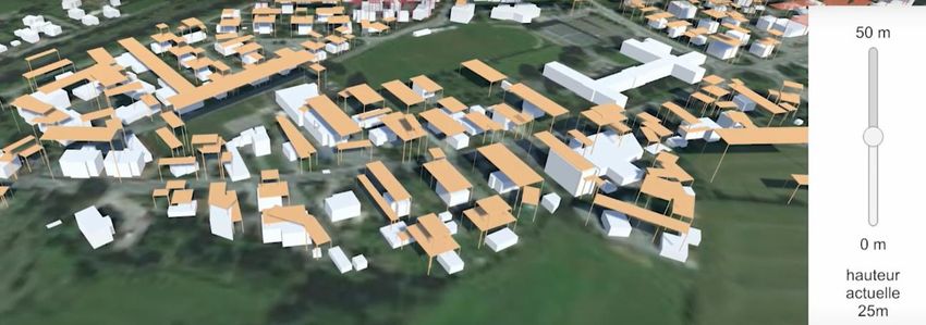
TARGETED ANALYSIS // DIGIPLAN – Digital plans and plan data in France

List of figures and tables
List of figures
Figure 1.1       The French planning system (2013) .................................................................................... 10
Figure 1.2       SCoTs of Rennes (2019) and Strasbourg (2016) ................................................................ 11
Figure 1.3       Section of interactive map of PLUi of Rennes ..................................................................... 12
Figure 2.1       Screenshot of géoportail de l’urbanisme ............................................................................. 13
Figure 2.2       Plans available on géoportail de l’urbanisme by May 2021 ................................................. 14
Figure 2.3       Phases towards digital plans and plan data in France......................................................... 17
Figure 3.1       CRIGs – regional geodata platforms in France ................................................................... 20
Figure 3.2       PLU of Strasbourg, geoportal .............................................................................................. 21
Figure 3.3       PLU of Strasbourg, PDF-version ......................................................................................... 22
Figure 4.1       A retrievable “fiche” on the PLU regulations for a specific parcel in Rennes ....................... 26
Figure 4.2       Manuals for different user groups available on GPU ........................................................... 27
Figure 4.3       SmartPLU tools to check allowed building heights .............................................................. 30

List of tables
Table 1.1        Interviews held ...................................................................................................................... 9
Table 2.1        Planning instruments included in géoportail de l’urbanisme ................................................ 14
Table 2.2        Examples of geodata portals with plan data in France ........................................................ 15
Table 2.3        Phases and milestones in digital plans in France ................................................................ 16

6   ESPON // espon.eu
TARGETED ANALYSIS // DIGIPLAN – Digital plans and plan data in France

Abbreviations
ADEUS     Agence de développement et d'urbanisme de l'agglomération strasbourgeoise (Develop-
          ment and town planning agency for the Strasbourg agglomeration)
CC        Carte communal, a simplified land use plan for rural areas
CIGAL     Cooperation for geographic information in Alsace
CNIG      Conseil national de l’information geographique (National council of geographic information)
CRIGE     Constituted bodies of regional coordination of geographic information
DAC       Document d'aménagement commercial (business development plan)
DINUM     Direction interministérielle du numérique (Interministerial directorate for digitalisation)
DOO       Document d'orientation et d'objectifs (document presenting the goals and orientations)
DTADD     Directive Territoriale d'Aménagement et de Développement Durables (Territorial planning
          directive)
DU        Document d’urbanisme (local planning document)
GPU       Geoportail de l’urbanisme (geoportal dedicated to digital plan data from public authorities)
IGN       Institut national de l’information gégraphique et forestrière (National institute for geographic
          and forest information)
OAP       Orientations d'aménagement et de programmation (planning and programming orientations)
PADD      Projet d'aménagement et de développement durable (project for the sustainable develop-
          ment of the territory)
PLU       Plan local d’urbanisme (municipal land use plan)
PLUi      Plan local d’urbanisme intercommunal (municipal land use plan for several municipalities)
POS       Plan d’Occupation des Sols, the predecessor of the PLU (until 2000)
RNU       Les dispositions impé-ratives du règlement nation-al d’urbanisme (National planning regula-
          tions)
SCoT      Schéma de coherence territorial (Scheme for territorial coherence, a strategic structure plan)
SRADDET   Schéma régional d'aménagement, de développement durable et d'égalité des territoires (Re-
          gional scheme for land use, sustainability and territorial equality)
SRI       Sérvice de la Recherche et de l'Innovation (National service of research and innovation)
SUP       Servitude d’utilité publique (Schemes of public services)

                                                                                      ESPON // espon.eu    7
TARGETED ANALYSIS // DIGIPLAN – Digital plans and plan data in France

Foreword by the research team
The ESPON DIGIPLAN project explored the development and state of digital plans and plan data in several
European countries. It is the first of its kind; no similar research has been conducted before and the topic of
inquiry was spanning wide from the beginning. The project employed therefore an explorative character to
shed light on digital practices in different spatial planning contexts but also presents an early systematisation
of general concepts, key terms and approaches describing emerging digital plans and plan data and related
practices.

This report is one out of six in-depth case studies, presenting findings from France. No French stakeholder
was connected to the DIGIPLAN project, but several interviews with practitioners from different levels of
governance provided insights into various aspects of digital planning practices. As with the other case stud-
ies, we do not aim at giving a full picture of digitalisation of plans and plan data in France. This would go far
beyond the scope of DIGIPLAN. Instead, we provide insights from different places in the planning system
and in the country on current developments and challenges.

In France we focus e.g. on the national plan data portal GPU, the work with plan data in the cross-border
region of the Upper Rhine and the digital plans in the city-regions of Strasbourg, Alsace, and Rennes, Bre-
tagne. France is on an extremely interesting path in the digitisation of plans and plan data. There are strong
national standardisation tendencies, but at the same time an enormous activity at the local level. However,
the discussion on planning as such and if we get better plans (and better places) with digitisation seems
sometimes subordinated to technical and administrative questions or, also, is digitisation not seen as having
an influence on planning practice yet. Still, the huge change in accessibility to plans and plan data – within
a few years already half of all plans in France are online – might just need some more time to unfold its
potential for informing planning itself.

8   ESPON // espon.eu
TARGETED ANALYSIS // DIGIPLAN – Digital plans and plan data in France

1 Introduction and data
ESPON DIGIPLAN provides an overview on digitalization of plan data in 15 ESPON countries, insight infor-
mation from case studies in 6 countries and five thematic practice papers, synthesizing the state of the art
in topics related to digital plan data and digital plans. This Annex reports on France, one of the 6 in-depth
case studies. The methodological framework for the case studies is described in Annex 1.

The main empirical material for the case study are information from the plan data portals and interviews with
experts in the field. We conducted six interviews with seven persons. The interviewees represent persons
from different levels of governance and practice. Information from interviews in the text are referenced by
(FR01) to (FR06), referring to an internal interview reference table. The interviews were conducted in French
or English, citations are own translations based on transcriptions if necessary.

Table 1.1
Interviews held

 Affiliation                       Position
                                   Expert for national geoportal
 National council of geographic
                                   Expert for national plan data geoportal
 information (CNIG)
                                   Expert for standards for digital plan documents

 Region Bertagne                   Expert for regional geoportal, DREAL Bretagne

                                   2 Experts for cooperation and GIS in the cross-border region Upper
 UpperRhine cross-border region
                                   Rhine, GeoRhena

 Strasbourg agglomeration          Expert and planner from public planning agency ADEUS

                                                                                          ESPON // espon.eu    9
TARGETED ANALYSIS // DIGIPLAN – Digital plans and plan data in France
1.1 The French planning system
Metropolitan France is organised into 13 regions, 95 departments and 35,013 municipalities (2021). Spatial
planning instruments intervene at different levels in France, though not on the level of departments. Among
them:
The SRADDET (regional perspective) defines medium and long-term objectives for territorial coher-
ence, infrastructure, rural areas, housing transport, energy, environment, waste etc. on a regional level.
The SCoT (territorial coherence plan) sets the strategic orientation for public policies in a spatial context,
on an inter-municipal level.
The PLU (local urban plan) / PLUi (inter-municipal urban plan) zone and regulate urban development.
The Carte communale (municipal map) specifies e.g. detailed building rights in smaller municipalities.
Figure 1.1 illustrates the hierarchy of planning instruments in France. The legal relationship between these
planning instruments is regulated by the principle of the “Hiérarchie des norms”; a pyramid of legal provisions
requiring different types of symbolic expression in plans, and thus a structured typology of plan data (struc-
tures, directions, zoning etc.). In terms of digital plans and plan data we focus on the SCoT and the
PLU/PLUi. The SCoT and the PLU exist since a planning reform in 2000.
Figure 1.1
The French planning system (2013)
Source: Geppert (2015). This part of the figure does only depict planning documents with direct implications for land use,
situation in 2013
10 ESPON // espon.euTARGETED ANALYSIS // DIGIPLAN – Digital plans and plan data in France
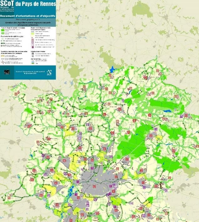
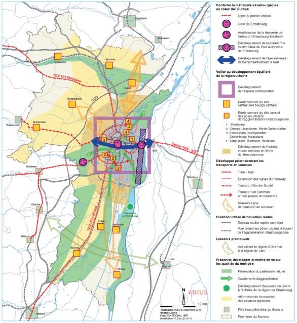
The SCoT – Schéma de coherence territoriale
The SCoT is a statutory French planning instrument designating a scheme for territorial coherence, typically
at the level of metropolitan areas or other urban agglomerations at a scale that exceeds the single munici-
pality. SCoTs can look very different. The SCoT Le Pays de Rennes1 (approved 29 May 2015) may serve
as illustration. It mainly deals with a number of sectoral policies, from housing, mobility and business devel-
opment to the environment and landscape, with the aim of making them coherent at the scale of several
intermunicipal units. The public entity behind the plan is a syndicate composed by 76 municipalities who are
organised in 4 intercommunalities (EPCI): Cormier communauté, Pays de Châteaugiron communauté,
Rennes Métropole et Val d’Ille - Aubigné. The content of the plan is organised in four components:
A presentation report (rapport de présentation) which explains the choices made to establish the project
(about 300 pages).
The project for the sustainable development of the territory (Projet d'aménagement et de développe-
ment durable – PADD), a mandatory document which fixes the objectives of the plan and alligns it with
principles of sustainable principles (68 pages).
A document presenting the goals and orientations (Document d'orientation et d'objectifs – DOO), which
explains how to implement and put the goals of the PADD into practice (88 pages including the main
strategic map).
A business development plan (Document d'aménagement commercial – DAC) which clarifies the sus-
tainable development orientations of the DOO in business areas (44 pages).
Figure 1.2
SCoTs of Rennes (2019) and Strasbourg (2016)
Source Rennes: http://www.paysderennes.fr/IMG/pdf/scot2015_doo_approuve_22102019_carte_web.pdf, access May
2021
Source Strasbourg: https://wxs-
gpu.mongeoportail.ign.fr/externe/documents/scot_256702705/e46e96571729b9f835c12163a262f9aa/256702705_padd
_21102016.pdf, accessed May 2021 over GPU
1
http://www.paysderennes.fr/-Organisation-du-territoire-aujourd-.html, accessed May 2021
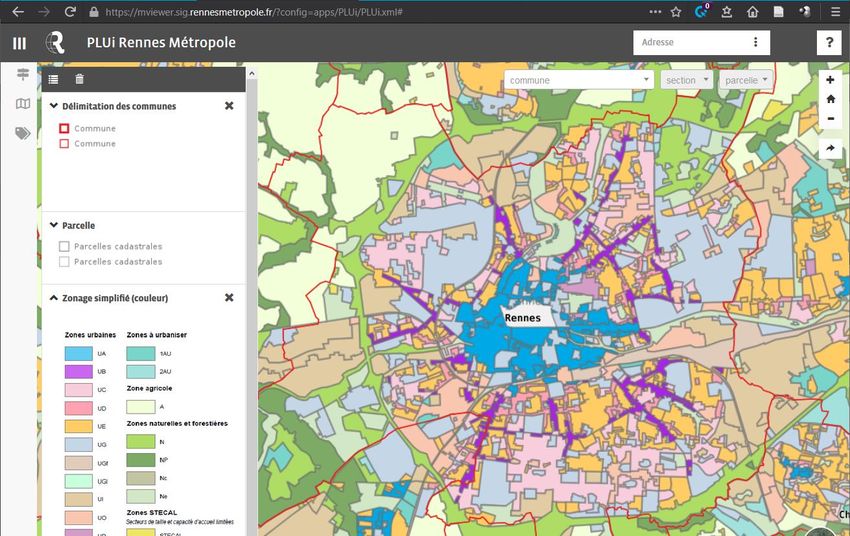
ESPON // espon.eu 11TARGETED ANALYSIS // DIGIPLAN – Digital plans and plan data in France The PLU and PLUi – Plan local d’urbanisme (intercommunal) PLU is a statutory plan, a "local city plan", providing zoning for each municipality (plan local d'urbanisme). In larger agglomerations municipalities may organise and provide a PLUi, an intermunicipal local city plan (plan local d'urbanisme intercommunal), with the same provisions and status as a PLU, but with a collabo- ration of municipal authorities behind it. A PLU uses four general zoning categories2, which can be further specified: Zone U – Urban zones where new construction is permitted Zone AU – To be urbanised zones, where infrastructure is already available or planned. Zone A – Agricultural zone, where any construction must be related to agricultural production Zone N – Nature areas which are generally protected from new construction Using the example of the Rennes metropolitan area again, the PLUi de Rennes, ville et métropole (effective since 4 February 2020) is a coordination of plans for 42 municipalities in the metropolitan area. It integrates the PADD, which defines the political ambition of sustainable development towards 2030, found in the SCoT, and provides it with a zoning instrument on a local level of governance. Here the scale is similar to the SCoT for the same area, but the example shows a different role of the PLUi, and thus the specificity of the PLU plan type. The PLUi must be in conformity with plans that are hierarchically superior, leading to document attachments such as the PLUi HD (habitat et déplacement), coordinating land-use, housing and transporta- tion. The PLUi contains a large number of technical documents, in the form of local zoning plans, in accord- ance with planning and programming orientations (orientations d'aménagement et de programmation – OAP), a component which highlights certain sectors on a municipal basis. Figure 1.3 Section of interactive map of PLUi of Rennes Source: https://mviewer.sig.rennesmetropole.fr/?config=apps/PLUi/PLUi.xml#, accessed May 2021 2 Source: https://www.french-property.com/guides/france/building/planning/local-plans/plan-local-urbanisme/, accessed May 2021 12 ESPON // espon.eu
TARGETED ANALYSIS // DIGIPLAN – Digital plans and plan data in France
2 Scope of digital plan data
2.1 The current state of digital plan data
The public French geodata system is based on a main geoportal, allowing the global diffusion of geodata.
Managed by the IGN (National Institute of Geographic and Forest Information). This main database is refer-
encing every geodata available to the public, with many tools and possibilities of utilisation. This is illustrating
what is called the Etat Plateforme (E-government), a deeper digitisation dynamic of all public services. From
this main platform, users can access different dedicated sub-geoportals and applications. One of them is the
Geoportail de l’urbanisme (GPU), dedicated to digital plan data from public authorities.
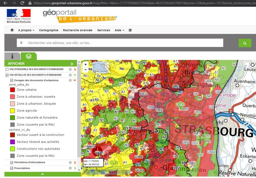
Figure 2.1
Screenshot of géoportail de l’urbanisme
Source: https://www.geoportail-urbanisme.gouv.fr, accessed 22 February 2021
The GPU was established in 2013, a first version was online in 20163. It includes currently the main planning
documents on municipal / inter-municipal level, including the PLU/PLUi and the SCoT. Coverage of available
plans is continuously increasing. Figure 2.2 presents a summary. Out of about 25,000 municipalities that are
expected to be covered by a local plan as a PLU4, data for 16,000 municipalities (64 %) is available on the
3
Source: https://www.geoportail-urbanisme.gouv.fr/info-general, accessed March 2021
4
Note that about 10,000 (25 %) of all 35,000 municipalities are not required to draw up a local plan, but are covered by
the national urban planning regulations (RNU regime). This concerns mainly small, rural municipalities.
ESPON // espon.eu 13TARGETED ANALYSIS // DIGIPLAN – Digital plans and plan data in France
GPU by May 2021. This is about 64 % of those which are expected to have a local plan available. On the
level of the SCoT, plan are available covering about 8,000 municipalities (35 %). The GPU has been estab-
lished as the platform for plan data from public authorities, which third parties rely on as well as develop
related digital products and services on.
Figure 2.2
Plans available on géoportail de l’urbanisme by May 2021
DU = document d’urbanisme (a local planning document)
Source: https://www.geoportail-urbanisme.gouv.fr/statistiques/france, accessed 22 May 2021
Table 2.1 lists the French planning instruments as summarised in the ESPON COMPASS project (2018)
and their availability in the GPU. All local / inter-municipal plans are covered by the GPU, on the national
level only the scheme for collective services (e.g. noise zones from airports) is available on the GPU. The
planning instruments not available have often a more general policy document character, without spatially
specific regulations.
Table 2.1
Planning instruments included in géoportail de l’urbanisme
Level Name in French English translation in GPU
Les dispositions impératives
du règlement national d’ur- National planning regulations No
National banisme (RNU)
Servitude d’utilité publique
Schemes of public services Yes
(SUP)
14 ESPON // espon.euTARGETED ANALYSIS // DIGIPLAN – Digital plans and plan data in France
Level Name in French English translation in GPU
Directive Territoriale d'Amé-
nagement et de Développe- Territorial planning directive No
ment Durables (DTADD)
Les directives paysages Operation of national interest No
Regional scheme for spatial
SRADDET planning, sustainable develop- No
Regional ment and equality
Ile de France Region’s master
Paris region master plan No
plan
Scheme of territorial coher-
SCoT Yes
Inter- ence
communal Local land-use plan for several
PLUi Yes
municipalities
Local PLU Local land-use plan Yes
(municipality) Cartes communales Municipal map Yes
Source: Own elaboration, based on ESPON COMPSS (2018)
However, some of it is available on more specific geoportals. Table 2.2 lists some examples. E.g. specific
data on environment and nature, which are part of the regional policy SRADDET can be accessed on re-
gional geodata portals (e.g. GeoGrandEst). Certain specifications as detailed annexes and regulations to a
PLU are not accessible over the GPU, but can often be accessed over local geoportals (e.g. OpenData
Strasbourg). For the cross-border region Upper Rhine, a specific geoportal called GeoRhena was developed
to make data across the French, German and Swiss border accessible.
Table 2.2
Examples of geodata portals with plan data in France
Name of portal Description Link
Géoportail National geoportal https://www.geoportail.gouv.fr/
Géoportail de l’urban- National geoportal for urban planning, in- https://www.geoportail-urban-
isme (GPU) cluding data on PLU and SCoT isme.gouv.fr/map
data.gouv.fr French open government data platform, https://www.data.gouv.fr/fr/search/?q=ur-
incl. downloads of various plan data banisme
GeoGrandEst Geoportal of Region GrandEst with a var- https://www.geograndest.fr
(to be renamed Data- ied collection of geodata, including perim-
GrandEst in 2021) eters of SCoTs in the region
Open Data Strasbourg Geoportal of Strasbourg, section on PLU https://data.strasbourg.eu/explore/da-
taset/carte_plu_detaille/custom/
GeoRhena Cross-border geoportal for the Upper https://sdi.georhena.eu/mapfishapp
Rhine region, incl. information on re-
gional planning instruments in all 3 part-
ner countries (SCoT on French side)
Accessed May 2021
ESPON // espon.eu 15TARGETED ANALYSIS // DIGIPLAN – Digital plans and plan data in France
2.2 The historical background
The institutionalized dissemination of geodata from public authorities on national level started in 2006, with
the creation of the Géoportail. The adoption of the INSPIRE directive in 2007, laid further foundations for the
dissemination, availability, use and reuse of geodata and the establishment of geographic information infra-
structure. On 19 December 2013 it was decided to create the Géoportail de l'urbanisme, a geoportal de-
cidcated specifically to plan data. In the Ministry of Ecological Transition (Ministère de la Transition
Écologique et Solidaire), where you find the INSPIRE contact point in France, the head of the national ser-
vice of research and innovation SRI (Sérvice de la Recherche et de l'Innovation), decided how this was to
be constituted in France. The development of the GPU has therefore within a rather short time period
changed digital access to plans in France significantly.
“Things are now very different from ten years before. Now in France, for PLU, we have
géoportail de l'urbanisme (GPU).” (FR06, 0:17)
The GPU is rather young. However, as in many other countries, digitisation of plans and plan data has a
manifold and longer history with efforts on different levels and in different communities. Already in 1977, the
city of Strasbourg created a special section for digital plan making in the administration 5. With the start of
use of GIS in the administration in the late 1980s in the administration, GIS got official introduced in the
beginning of the 1990s. One of the main tasks of the time was the digitisation of the cadastral maps to create
a digital land register as reference data. Individual enthusiasts and progressive departments in the admin-
istrations drove this phase.
Table 2.3
Phases and milestones in digital plans in France
Time Main activities Examples
1990s Digitisation of cadastre, 1985: CNIG established
GIS projects in various au- 1991: GIS start in Strasbourg’s geomatic department
thorities
1996-2004: Digitisation of cadastral maps, production of land registry
reference data in Strasbourg
2000s Establishing networks and 2002: Regional partnership “Cooperation for geographic information in
partnerships around GIS, Alsace” (CIGAL), incl. Strasbourg
geoportals get created, 2004: Upper Rhine conference establishes GeoRhena
GIS infrastructure and
standards developed 2006: National Géoportail starts
2006: CNIG elaborates first standards for digital planning documents
2007: INSPIRE directive
2009: Network of regional geodata platforms established
2010s Broad digitisation of plans 2016: Géoportail de l’urbanisme (GPU) online
and plan data, improve- 2016: Authorities must make plans available online (own site or GPU)
ment of accessibility, inclu-
sion in law 2018: GeoGrandEst platform launched
5
https://sig.strasbourg.eu/index.php?page=mis_histo, accessed May 2021
16 ESPON // espon.euTARGETED ANALYSIS // DIGIPLAN – Digital plans and plan data in France
Time Main activities Examples
2020s Completion, inclusion of 2020: Publication of plans on GPU becomes mandatory
further planning instru- 2021: GéoGrandEst becomes DataGrandEst, establishing a regional
ments, dynamic integration data platform
in the wider administration,
automation of data ex-
change
Source: Own work
In the 2000s, the main direction for the further development was developed through networks, partnerships
and finally directives, including the INSPIRE directive (2007) but also the establishment of the national geo-
portail in 2006. In the same year first technical standards for digital plans were developed. An organisational
structure was established, slowly institutionalising digitisation on various levels. In the 2010s plan data gets
on the agenda more broadly, with the development of the GPU and the refinement and expansion of stand-
ards by the national geodata council (CNIG) for various plan types. Since 2016, planning authorities must
make plans available online, and since 2020 this has to be done over the GPU. The data in GPU will con-
tinuously become more complete, while an integration of the GPU and other plan data portals in a more
general open and dynamic data environment can be expected, including the automation of data exchange.
Table 2.3 and Figure 2.3 summarise the phases and some milestones in digital plans in France.
Figure 2.3
Phases towards digital plans and plan data in France
2010s
1990s
Digitsation,
GIS projects accessibility, legal
Digital cadastre basis
2000s 2020s
Networks, Completion,
institutions & integration,
standards automation
Source: Own work
ESPON // espon.eu 17TARGETED ANALYSIS // DIGIPLAN – Digital plans and plan data in France
3 Organisation of digital plan data
The main actors in digital plan data are (1) on the national level incl. ministries, agencies and councils in the
role of legislator defining the planning code and procedures for digitalisation, administrators of data infra-
structure and designers of standards for plans, and (2) on the local level the municipalities as the main
planning authority in terms of land use. Municipalities very often though cooperate to deliver joint plans for
the local (PLUi) as well as the city-regional level (SCoT). Regions and other authorities can be important to
provide regional geodata or infrastructure (databases, geoportals). Little by little, especially since the reduc-
tion of the number of French regions in 2016, France is starting to get something more clear in terms of
national infrastructure. When it comes to platforms there is a national level, a regional level, and first of all
the metropolitan areas have each one their platforms, and the districts have theirs.
3.1 Digital plan data at the national level
DINUM - Direction interministérielle du numérique (interministerial directorate for digitalisation)
DINUM was established in 2019 to be in charge of the digital transformation of the state. The directorate
drives several programmes and services, which shall support that transformation on different levels and
fields of public administration. This includes the TECH.GOUV programme focusing on the digitalisation of
public services or ETALAB, which coordinates and France’s open data strategy and manages related portals
as https://data.gouv.fr (open government data) or https://cadastre.data.gouv.fr (digital cadastre of France).
Digital cadaster data are freely available. However, coverage is not complete (yet) and depends on data
provided by the municipalities. Historical data going back to 2017 is available. IGN is offering a detailed
cadaster data set which is not freely available.
IGN – Institut national de l’information gégraphique et forestrière (National institute for geographic
and forest information)
The IGN was established in the 1940s. It produces, collects, qualifies and disseminate sovereign geographic
and forest data to support public policies. The IGN is the main body in France for providing geodata and its
infrastructure. It is responsible for the national geoportal (established in 2006) as well as for the GPU, the
geoportal for planning.
Code de l’urbanisme (Urban planning law)
The Code de l’urbanisme defines the processes and contents of urban plans, regulating land use, except
for agricultural production, and in particular the location, service, layout and architecture of buildings. The
use of the GPU is mandated in article L133, where it says that planning documents must be transmitted in
digital form to the state. The format to of the transmission is specified by a state decree.
CNIG – Conseil national de l’information geographique (National council for geoinformation)
The CNIG was established in 1985 and reorganized a couple of times. Today it has 35 members with rep-
resentatives of nine ministeries, public agencies (incl. IGN), regional and local authorities (e.g. from the
association of cities) and professionals in geographic information. The president of the CNIG is a member
of parliament and it has a permanent secretariat, hosted by the French INSPIRE contact point and in collab-
oration with the IGN.
“The CNIG is the main leading structure about national data.” (FR05, 0:53)
The CNIG is a key institution regarding digitisation and standardisation. In the field of planning, CNIG pro-
vides “Prescriptions nationales pour la dématérialisation des documents d’urbanisme” – national rules for
the digitisation of planning documents, not least for their integration in the GPU. There are standards and
18 ESPON // espon.euTARGETED ANALYSIS // DIGIPLAN – Digital plans and plan data in France
technical guides for every planning instrument at the municipal or inter-municipal level6 as well as for certain
national planning instruments. The standards become mandatory when the law / decrees refers to them.
Standards typically include (see for example for PLU in CNIG, 2017):
a conceptual data model and a catalogue of objects
format, organisation and naming of files
topology rules (the structure of spatial data)
geo-referencing system
CNIG’s approach to digitisation has been a gradual transition, i.e. means increasingly more data is digitised
and in more accessible (e.g. machine-readable) forms.
GPU – Geoportail de l’urbanisme (Plan data geoportal)
As written above, the GPU is hosted by the IGN and guided by the standards of the CNIG.
The GPU allows to
Identify the zoning and the planning regulations which apply to a parcel, direct;
Consult all or parts of the planning documents (geographical data and municipal regulations);
Consult information on the public utility easements affecting the land use;
Download geographic (zoning) and literal data (regulations in .pdf format);
Overlay other layers (selection of prescriptions, cadastre, aerial photos etc.);
Create and distribute your own map (prescriptions to represent, drawing tools).
The CNIG standards are mainly technical nature, but in the GPU certain aesthetical harmonisation are done.
E.g. municipalities can choose colours for zoning categories freely, but the GPU assigns a common symbol-
ogy to all town planning documents of the same type. E.g. the zoning AU (“to be urbanised”) appear the
same colour regardless of the territory.7 Most recently though (March 2021), a working group of CNIG has
drafted guidelines for the symbolisation of plans (in the GPU as well as in any other portal or format) with
the ambition to distribute standard style files to be used in GIS software (CNIG, 2021b). The guidelines are
still a working document.
3.2 Digital plan data at the regional level
“It's not so long that the different GIS levels work together. They were splitted or not working
together. Since maybe five or 10 years they work together.” (FR05, 0:17)
The current Regions were established with a structural reform, which included the merger to bigger regions,
in 2015/2016. Regions are responsible for the regional plan SRADDET, which is more a regional policy
instruments. However, more important for digital plan data is the establishment of regional geodata services.
One of them is GéoGrandEst. Although driven by the region of GrandEst, certain departments and other
public authorities contribute to its financing, allowing to develop further services and to take part in the gov-
ernance of GéoGrandEst. These regional geodata services are sometimes also called CRIG, literally the
regional version of CNIG. Figure 3.1 shows the current CRIGs in France.
The CRIGs main role is the maintenance and provision of geodata, not directly plan data..
“The main obligatory competence of GIS data is the region, like Region Grand Est. For exam-
ple, in the department it's not compulsory to have a GIS database, but for Region Grand Est
it's compulsory.” (FR05, 0:17)
6
They can be found on http://cnig.gouv.fr/?page_id=2732, accessed May 2021
7
See https://www.geoportail-urbanisme.gouv.fr/faq/#faq_99, accessed April 2021
ESPON // espon.eu 19TARGETED ANALYSIS // DIGIPLAN – Digital plans and plan data in France
“The CRIG is more about geodata, but not planning data. It's really separate in France. Plan-
ning is not geodata.” (FR05, 0:54)
“What is interesting with GéoGrandEst is the capacity of checking information. I think they
make a common platform to share different kind of data for all the region, but it's not only for
planning information.” (FR06, 0:59)
Figure 3.1
CRIGs – regional geodata platforms in France
Source: AFIGEO, https://www.afigeo.asso.fr/groupes-de-travail/reseau-des-criges, accessed 15 May 2021
However, the region’s geodata is also an input to the regional policy SRADDET.
“GéoGrandEst is a tool for regional policies which survey the land use in the regional area for
the application of the SRADDET. They need tools for the survey, the application of
SRADDET.” (FR06, 1:07)
Furthermore, the CRIG’s have become a central data collector also for some plan data, especially those
closer to the regional level like the SCoT.
“For that example, in France, the SCoT database was put together from the Region GrandEst.
So they have the data, they maintain it and update it.” (FR05, 0:16)
This transformation can also be seen in the forthcoming (during 2021) renaming of GéoGrandEst to Data-
GrandEst, which should highlight its role as a general public data provider, not limited to geographic data.
CRIGs are organised in a network. Since 2009 (that time with predecessors of the current CRIGs) the net-
work “plateformes régionales d’animation territoriale autour de l’information géographique” meet regularly.
20 ESPON // espon.euTARGETED ANALYSIS // DIGIPLAN – Digital plans and plan data in France
3.3 Digital plan data on local level
Municipalities or municipal cooperations are the main planning authorities on local level, responsible for
major planning instruments as SCoT or PLU/PLUi. The state of digital plans and plan data on that level is
very diverse. The following shows the situation for the Eurometropol Strasbourg, an intercommunal cooper-
ation (French: metropole) of 33 municipalities, and of smaller municipalities in the Lower Rhine area.
Example: PLU of Eurometropol Strasbourg
Eurometropol Strasbourg has a central data portal called “Open Data Strasbourg.eu” (https://data.stras-
bourg.eu), which was created in 2019. A previous version of the geoportal, the StrasMap, was online since
2011, but Strasbourg has a long history in working with geodata, with the first official introduction of GIS
software in 1991.
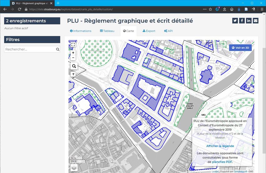
Plan data is published over the central data portal. For the local plan, the PLU, all detailed graphical regula-
tions can be viewed in the portal Figure 3.2. A disclaimer in the geoportal notes that “Les documents oppos-
ables sont consultables sous forme de planches PDF”. This means that the legally binding documents are
not the geodata, but the plan as PDF. The interface provides a direct links to the PDF version of the plan
(Figure 3.3). The two versions show the same information in the same way. Note that on the GPU, PLUs
are visualised only in broad, harmonised zoning categories and not in the same detail as in that example.
However, the PDF with the detailed plan can also be accessed over the GPU.
Figure 3.2
PLU of Strasbourg, geoportal
Source: Screenshot from https://data.strasbourg.eu/explore/dataset/carte_plu_detaille/custom, accessed May 2021
ESPON // espon.eu 21TARGETED ANALYSIS // DIGIPLAN – Digital plans and plan data in France
Figure 3.3
PLU of Strasbourg, PDF-version
Similar section of PLU as in the previous figure. Source: https://sig.strasbourg.eu/datastrasbourg/plu_planches/6.1-
PLU_zonage%202000/6.1-PLU_zonage2000_32_092019.pdf
The city also offers a specific 3D viewer8, where 2D plan data from the PLU (or other data) can be viewed
on top of a 3D model.
Example: smaller municipalities in Bas-Rhin (Lower Rhine)
“For the example of Strasbourg, you have a local system, local application to access the infor-
mation. I think it's a very good system. But if I take the example of a rural place, which I know,
you have no other solution than to use the GPU. You could go to the municipalities, of course.
I think on the websites you have PDF access. But you will not find a geoportal.” (FR06, 0:55)
Many smaller municipalities do not have the same possibilities as big municipalities or intercommunal coop-
eration. However, they still have the same obligation to publish plan data online, since 2020 on the GPU.
Municipalities in the department Bas-Rhin publish the PDFs of their plans on a joint portal9, provided by
ATIP, a public owned engineering consultancy for the region. The portal includes a simple database interface
where plans for a specific municipality can be retrieved.
3.4 Other actors
Many planning tasks are not done by the public planning authorities themselves, but by private planning
offices or public owned agencies. We have already mentioned ATIP 10, a public owned engineering consul-
tancy. It currently serves around 500 local authorities in the Lower Rhine region. ATIP supports plan making,
but, as written above, also the publication and its digital accessibility. A similar public consultancy is
8
https://3d.strasbourg.eu/CESIUM_OPENDATA/?open=enableODPLUdetaille, accessed May 2021
9
https://diffusion.atip67.fr/birt-viewer/run.do?__report=report/client1/atip/atip_posplu.rptdesign, accessed May 2021
10
ATIP - L’Agence Territoriale d’Ingénierie Publique, https://www.atip67.fr, accessed May 2021
22 ESPON // espon.euTARGETED ANALYSIS // DIGIPLAN – Digital plans and plan data in France
ADEUS11, serving around 140 local authorities in the Strasbourg metropolitan area, including Eurometropol
Strasbourg itself. ADEUS provides support in all phases of plan making. ADEUS does not have an own
geoportal, but provides digital tools for plan making to its members and maintains or monitors plan data-
bases.
The Franco-German-Swiss Conference of the Upper Rhine, an institutional framework for cross-border co-
operation, has developed the open data portal GeoRhena. GeoRhena is a geoportal, bringing together data
from the three neighbouring regions. It also includes plan data, but stays on the regional level (in France the
SCoT).
“We work with SCoT data, only the big data, but with the PLU, it's too fine, too detailed. You
cannot compare state of the art data from the PLU on Gemeindedaten. It's really complicated
on the regional level for the planer to understand what is inside, how is it built, how is it up-
dated.” (FR05, 0:25)
Many private planning offices (studios) help municipalities making the plans or organise the plan process.
Moreover, private GIS or software companies provide tools for the digital administration of land and plans.
For example the company SOGEFI has a tool for public authorities called MonTerritoire, which can handle
various spatial data and integrate a municipalities data with data from other providers. The tool also inte-
grates the local plan (PLU) also connects the GPU (de Sulzer Wart, 2018).
3.5 Relations within different levels of government
In the development of standards for digital plans, the CNIG (see section 3.1) is a forum including all levels
of government and even the private sector. Representatives from the regional or local level are persons from
different associations as e.g. association of the urban communities, association of the large cities, federation
of the medium-sized towns, association of small towns etc. For a planner or an administrator in a local
authority, these can still ‘feel’ far away, but it is clear, that the standards need to be respected in the com-
munication with the GPU.
“First, we have to respect the standard. It's the CNIG […] We have to have the polygon, which
need to be closed, the input is verified by the application.” (FR06, 0:20)
There might though be only little insight into the making of these standards. It is clear that the national level,
represented by the national government but also by nation-wide associations have a significant influence on
digitisation through the CNIG.
The relation between regions or regional geodata services as GéoGrandEst and local authorities seems due
to the not very long history of regions still new and unclear. Certainly, it is seen as an interesting potential.
“It's not so long that the different GIS levels work together. They were split or not working to-
gether. Since maybe five or 10 years they use to work together.” (FR05, 0:17)
On a local level, digitisation of plans and plan data has made exchange between public authorities easier.
“But now in the processes with PLUi, when we exchange with [other public authorities], we
make the exchange with no paper. It's a digital plan, PDF, but it could be a shape file” (FR06,
0:25)
11
ADEUS - L’Agence de Développement et d’Urbamisme de l’Agglomération Strasbourgeoise, http://www.adeus.org,
accessed May 2021
ESPON // espon.eu 23TARGETED ANALYSIS // DIGIPLAN – Digital plans and plan data in France
In general, probably because the digitisation efforts are still very young in many cases, a lot of coordination
between stakeholders, sometimes organised in networks, seems necessary. The case of cross-border geo-
portals as GeoRhena, involves a lot of cooperation between different actors:
“And we do not only work with local authorities, but also with universities or with researchers
who work for us, for example in INTERREG projects. So we work with a lot of different ex-
perts.” (FR05, 0:15)
However, cross-border relations can also drive further action as was said by a planner from Strasbourg that
the German side expects from transparency on the French side of planning.
3.6 Relation between governmental and not-governmental actors
In the CNIG also representatives from the private sector and professional associations are included. For
example a recent working group on symbolization in plans was led by a representative from an intercommu-
nal authority and a representative from ESRI, the international company developing the GIS software ArcGIS
(CNIG, 2021b). Furthermore, the GPU is open to everybody and many technical interfaces exist. In public
planning agencies as ADEUS or GeoRhena, the main relations are to other public bodies, and the work is
very much oriented towards professionals.
“We work only with public partners. This means institutions or researchers. Our work is al-
ways free. We do not have any cost for our work, but we only work with public partners and
institutions, never with private.[…] With citizens, we could, but it never happened in the his-
tory.” (FR05, 0:45)
However, as with the GPU, many portals including GeoRhena or GéoGrandEst provide their data for free
and openly accessible. Sometimes also, specific formats or access points for different groups (see also
section 4.3) are available. Still, it was not possible to get much insight on relations to private companies.
Private actors are mainly seen as users of the data. Regarding citizens, digitisation and the availability of
plans and plan data is seen as an advantage and an increase in transparency. However, regarding the GPU
and other portals, data access is often limited to the adopted plans. Information on plans in the making and
from the planning process is not centrally available.
3.7 Financing
The IGN is responsible by a national decree to keep the national geoportal. It is in its portfolio of tasks; the
IGN receives financial funding from the State for that purpose. For the regions, it is more ambiguous. It is
organised differently, by constituted bodies of regional coordination of geographic information (CRIGE) 12.
The CRIGEs were constituted to organise geographic information based on the recommended model of
infrastructure for the regional level. They organise works, based on an economic model that forces them to
earn money. They are responsible for the regional platforms. While at the IGN there is a national level, with
a decree that comes from the ministries, asking it to organise the national geoportal, the planning geoportal
(géoportail de l'urbanisme) and soon there will be others. We can see that France is progressively orienting
towards an organisation of thematic platforms (FR1).
The costs of digitisation of plans cover the local authorities themselves. The CNIG provides though various
guidelines and tools. A current working document suggests to provide common style files for layouting plan
in GIS software (CNIG, 2021b).
12
https://www.afigeo.asso.fr/groupes-de-travail/reseau-des-criges, accessed May 2021
24 ESPON // espon.euTARGETED ANALYSIS // DIGIPLAN – Digital plans and plan data in France
4 Use of digital plan data
4.1 Use of digital plan data in the formal part of the planning
process
The GPU became part of the formal planning process in 2020. Since, the planning law (Code de l’urbanisme)
requires uploading of new plans to the national portal. Only planning authorities are able to publish over the
GPU. The GPU also offers certain validation procedures. Plans for technical validation can also be uploaded
by planning professionals.
Plans published in the GPU are though only adopted plans. Information on plans in the making or support
for the planning process is not part of the GPU. The GPU only documents the currently effective plans.
“What is not so good now is the time before [the plan gets adopted], which is a very, very im-
portant time. It's the time of the creating, the elaboration, the making. That's a big deal. Now,
we have no geoportal, we have a website and we put PDFs on the website to exchange with
the population, with the planning authorities.” (FR06, 0:34)
However, local authorities, especially the bigger ones, are also working with digital plans and plan data
portals in public consultation:
“The Eurometropol Strasboug, they make a special system, like the GPU, for the time of elab-
oration. But it's a voluntary decision of them. And I think it's very good because you need to
make that. Eurometropol Strasbourg is maybe 500,000 people. You need to have good sys-
tems to exchange with the population.”
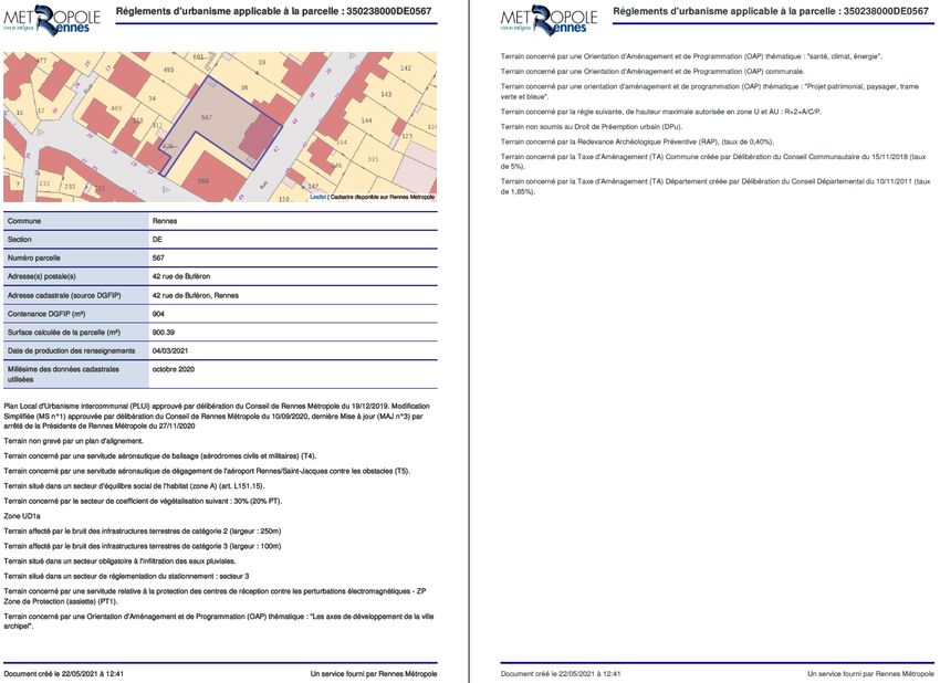
The plans and plan data on the GPU is not legally binding. As shown for Strasbourg (section 3.3), the digital
plan in the form of the PDF is the legally binding plan. An example from Rennes Metropole provides further
details how the status of digital plan data can be defined: Rennes Metropole’s PLUi is available over its own
geoportal13. The portal allows to produce individual fact sheets on regulations concerning a specific parcels,
called “fiche” (Figure 4.1). The interactive map complies with the approved PLUi and its subsequent adap-
tations and plan data is published at the latest 24 hours after its approval. A disclaimer on the ‘fiche’ therefore
states that urban planning information retrieved from the internet is only valid on the day issued. Also, the
fiche does not exempt users from checking other special regulations. Finally it is stated that plans reproduced
by screen printing have no legal value. However, because of the easiness of retrieving information in an
accessible format as the ‘fiche’, it can be assumed that the portal is the preferred way to get plan information.
Besides the local plan documents as SCoT, PLU/PLUi and CC, the GPU also publishes the schemes for
public services (SUP). These schemes are administrative limitations on property rights instituted by official
authority in a public purpose, drafted on the national level. The schemes become legally binding when avail-
able online.
13
https://mviewer.sig.rennesmetropole.fr/?config=apps/PLUi/PLUi.xml#, accessed May 2021
ESPON // espon.eu 25TARGETED ANALYSIS // DIGIPLAN – Digital plans and plan data in France
Figure 4.1
A retrievable “fiche” on the PLU regulations for a specific parcel in Rennes
Source: Retrieved over https://mviewer.sig.rennesmetropole.fr/?config=apps/PLUi/PLUi.xml#, May 2021
4.2 Use of digital plan data beyond the formal planning process
With its increasing coverage and the inclusion of more plan types, the GPU has become an important refer-
ence portal (Capart, 2019). The number of users of the GPU has increased continuously (FR04). Digital plan
data in general is seen as a big advantage in terms of being accessible online to everybody, allowing to use
the data for various purposes.
“I remember, I had a discussion with a friend who would like to buy a pharmacy and he said to
me, I see that here you have future planning for residential, then it could be a good place. I
think even for little retails, they check it.” (FR06, 0:44)
But also the public authorities are using the data themselves, e.g. for analyses of land use or risk analysis
combined with other data.
“[Supervising planning authorities] use it to make land consumption analyses. They can make
different analysis, than they could make with the paper [plan].” (FR06, 0:26)
“… we use now these data to monitor in real time the void, the waterproofing. There is a tool
to mix these data to check and evaluate.” (FR06, 0:46)
However, at the portals and data providers themselves, very often, knowledge on data use is missing:
26 ESPON // espon.euTARGETED ANALYSIS // DIGIPLAN – Digital plans and plan data in France
“We do have a map, we do have the data, but how it is used afterwards, we have not each
time feedback.” (FR05, 0:37)
4.3 Accessibility
The GPU as well as the other mentioned examples for plan data portals are open to everybody. Typically,
there is a viewer with different functionality, search functions and links to further documents (e.g. the PDF
plan versions). The digital and online availability of plans has increased transparency and made it easier for
citizens to access information.
“I think the GPU is useful for the citizens, that's for sure, because it's easier for citizens. Be-
cause they can access very easily the information and they are sure that the information is
up-to-date. Because you have not a plan every ten years. In big cities each year you have a
new version. Then it's very useful to have a digital website, then you are sure that the infor-
mation is up-to-date.” (FR06, 0:52)
The GPU has also produced guides for different user groups (see Figure 4.2), including video tutorials and
has been organising workshops or several regional user conferences (“Journée Géoportail de l'urbanisme”).
Figure 4.2
Manuals for different user groups available on GPU
Source: https://www.geoportail-urbanisme.gouv.fr/manuals/
In the case of a PLU, most data is available over the GPU, but there might be some minor parts which are
only accessible over the municipalities website:
“Then we have standards from CNIG […]. We have to have the polygon, which need to be
closed, the input is verified by the application. That's for the plan. We also need to send all the
different documents by PDF. Maybe not the Annex, but 90 or 95 % of the plan, which is down-
loadable on the geoportal.” (FR06, 0:20)
In the case of GeoRhena, the cross-border GIS platform of the Upper Rhine conference, accessibility also
includes the special aspect of language:
“We work with these experts and those experts say we have a need. This need is to have a
common database and a common representation. They come to us and say that's our data
[…] Our job is to put them together, to document them with metadata in French and in Ger-
man, because the main problem is the language, but also to put them together in a database
with the same attributes, and to distribute them.” (FR05, 0:20)
For geodata in more general, not all available data will be published always because of certain restrictions.
Nevertheless, metadata can then be published as a minimum:
ESPON // espon.eu 27You can also read