CHAPTER 4: CULTURAL & HISTORIC RESOURCES - City of New Berlin
←
→
Page content transcription
If your browser does not render page correctly, please read the page content below
CHAPTER 4:
CULTURAL & HISTORIC
RESOURCES
Revisions approved by Council on 6/14/2016 via Ordinance #2568
INTRODUCTION
The mission of the New Berlin Landmarks Commission is to serve the
people of the City as stewards of improvements and districts, and to
develop historical, cultural, social, political and economic interest in our
community. Continuation of our heritage for current and future
generations is accomplished through the perpetuation and use of such
improvements and districts, and by educating the citizenry and fostering
in them a deep sense of civic pride in the beauty and noble
accomplishments of the past and present. The Landmarks Commission
was created by Common Council Ordinance No. 897 on May 23, 1989.
The Commission is made up of 9 members (8 are appointed by the
Mayor, and 1 is appointed by the Common Council President.)
Members serve 3-Year Terms.
Another community group charged with promoting the City’s historic
resources is the New Berlin Historical Society. The Historical Society is
dedicated to the 4 R's: Rescuing, Restoring, Recreating, and Recording
authentic New Berlin History. The Society was founded in 1965 in an
old farmhouse on Cleveland Avenue.
What is Historic? Webster’s defines “historic” as “dating from or
preserved from a past time or culture.” The City of New Berlin has a
variety of historic and cultural resources ranging from historic homes to
an antique apple orchard. The City’s Landmarks Commission is
authorized to designate landmarks, landmark sites and historic districts
within the City’s limits.
The purpose of the Landmarks Commission is to:
Increase public awareness of the City’s origin, development, and
historic significance;
To conserve, protect and preserve the unique qualities and
distinctive historic characteristics of the community; and
New Berlin 2020 Comprehensive Plan 4:1
To facilitate restoration and rehabilitation of historic structures,
landscape features and other culturally significant physical objects
and geographic areas.
HISTORIC CHARACTER
The City of New Berlin was established in 1959, but early settlers made
New Berlin their home long before then. The first settlers, Sidney
Evans and P.G. Harrington and his wife, came in 1836. Mentor was the
original name of the township, but Mr. Evans changed the name to New
Berlin on January 13, 1840. Between 1850 and 1950, New Berlin's
population went from 1,293 to 5,334. Ten years later, in 1960, the
population had nearly tripled to 15,788. New Berlin was primarily an
agricultural community with commerce hubs on Prospect Hill (near
Racine Avenue and National Avenue) and at the New Berlin Center
(near National Avenue and Calhoun Road). See Exhibit A for a map of
New Berlin in 1873. The first Master Plan for New Berlin was adopted
in 1947. See Exhibit B for zoning maps from 1959 and 1970.Today
New Berlin is a growing suburb of Milwaukee that has managed to
maintain its rural character. The east side of New Berlin consists of
higher density homes, commercial corridors along National Avenue,
Moorland Road, Greenfield Avenue, and a strong industrial base. The
west side of the City maintains a rural feel with large lot single-family
residential homes and agricultural uses.
Current resources on the City’s cultural and historic resources can be
found in numerous places, including the New Berlin Public Library and
the Historic Park on Prospect Hill. The New Berlin Almanac is prepared
by the Historical Society and also contains a great deal of information
about New Berlin’s past. The first Almanac was published in 1965.
Other resources for Historic and Cultural preservation:
Waukesha County Historical Society
National Register of Historic Places
Wisconsin Historical Society
4:2 New Berlin 2020 Comprehensive Plan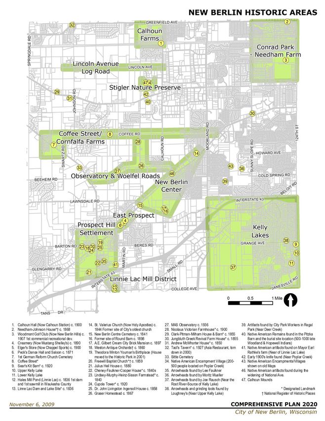
PAST AND CURRENT ACTION TO PROTECT
AND PROMOTE HISTORIC & CULTURAL
RESOURCES
The Historical Society currently holds four special open houses a year;
including an Ice Cream Social, Historic Days, and Applefest. There are
two annual full membership meetings and the board of directors meets
monthly. The New Berlin Historical Society has also been producing
the New Berlin Almanac since 1965. The Alamanc is a valuable
resource to learn about New Berlin’s past.
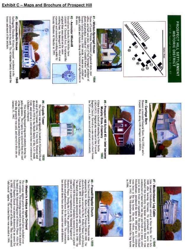
In 1977, the City of New Berlin purchased the property now known as
Historic Park on Prospect Hill. The Historic Park is a City-owned park
located in the heart of the Historic District. The Park consists of the
Winton-Sprengel House and Carriage House, the Youman-Martin
House, the 1863 School House, the Meidenbauer log cabin, the Copula,
and the new Gazebo. Historical Park has recently expanded to include
the Weston Antique Apple Orchard located across the street at 19760
West National Avenue. The Society has since restored the house to its
early 1900's period, recreated a country store in the Carriage Building,
moved and restored a local log cabin, rescued and restored an 1863
one-room school house. Exhibit C includes descriptions of the buildings
in Historic Park along with a map of the park.
The historic buildings are operated by the New Berlin Historic Society
and the buildings are open for tours. The Historic Society also offers
half-day field trips for fourth graders where they can learn what is was
like to study when several grades were taught in the same room with
one teacher. They use slates and only one sheet of paper a day. The
students read from McGuffey readers and boys and girls sit in separate
rows and have separate sides of the playground for recess.
The City also adopted Municipal Code Chapter 141: Historic
Preservation on October 10, 2000. This chapter of the municipal code
identifies and defines the purpose of the Landmarks Commission and
also describes the procedures for designating a Landmark Site. The
purpose of Chapter 141 is to:
1. Effect and accomplish the protection, enhancement and
perpetuation of such improvements and of districts which
represent or reflect elements of the City's cultural, social,
economic, political and architectural history.
New Berlin 2020 Comprehensive Plan 4:3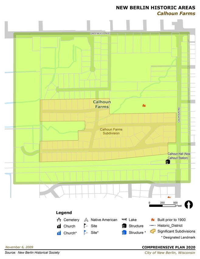
2. Safeguard the City's historic and cultural heritage as embodied
and reflected in such landmarks and historic districts.
3. Stabilize and improve property values.
4. Foster civic pride in the beauty and noble accomplishments of
the past.
5. Protect and enhance the City's attraction to residents, tourists
and visitors and serve as a support and stimulus to business and
industry.
6. Strengthen the economy of the City.
7. Promote the use of historic districts and landmarks for the
education, pleasure and welfare of the people of the City.
The following sites are currently on the Wisconsin National Register of
Historic Places:
Freewill Baptist Church - 19750 W. National Ave.
Needham, Enoch Gardner and Mary Caroline Koch, House -
12713 W. Greenfield Ave.
Weston's Antique Apple Orchard - 19760 W. National Ave.
The properties listed below are landmarks that have been designated
by the Landmarks Commission (photos of each Landmark are also
available on the City of New Berlin website: http://www.newberlin.org).
Andrew McWhorter House (c. 1850) – Located at 20635 West
Cleveland Avenue is a Greek Revival style cream city brick house
built by Andrew McWhorter. Andrew McWhorter was one of the first
settlers in New Berlin. He purchased the land through a land grant
in 1839. A new owner added the kitchen 1910. The house was
sold several times and the owner in 1988 subdivided the property
and planned to demolish the house. Fortunately, that did not
happen and the property was again sold. The house is now being
restored to its original state and was designated a New Berlin
Landmark on October 24, 2000.
Cheney-Faulkner-Cooper House (c. 1840’s) – Located at 5810 S.
Racine Avenue, Wisconsin's First Freewill Baptist Church
Congregation was formed in his house on July 11, 1840. It was
Rev. Rufus Cheney (born in 1780 in Antrim, New Hampshire) who
established Freewill Baptist Congregations in New York State and
Ohio en route to the Wisconsin Territory where he settled at the
4:4 New Berlin 2020 Comprehensive Plan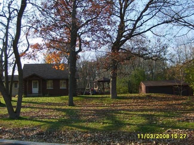
foot of Prospect Hill and organized his last congregation. The
Prospect Hill School was also founded in this house. Designated a
New Berlin Landmark on December 9, 1997.
Clark-Pitman-Milham House and Barn (c. 1855) – Located at
20900 W. Cleveland Avenue, the house was built for Lucian Clark
in 1855. The two–story Greek Revival house (Figure 4.1) is a very
well preserved example of an affluent dwelling of the 1850s. The
addition to the house was built c. 1865 for Pitman. The barn was
built in 1885 by Mike Lehnerer. The house was purchased by the
Jacob Milham family in 1872. Designated a New Berlin Landmark
on August 24, 1999.
Coffee Street - Prior to New Berlin becoming a city, Coffee Road
Figure 4.1. Clark-Pitman-Milham House
was known as Coffee Street. Coffee Street connected Racine
Avenue with Mukwonago Road (now National Avenue) and was a
one track gravel road which passed through a German
neighborhood and Little Grove School District. Passersby would
stop along Coffee Street to sample their neighbor's coffee bubbling
on the back of each home's big black stove. To recognize the
historic and cultural heritage of Coffee Street for the education,
inspiration, pleasure and enrichment of the citizens of the City of
New Berlin, decorative signs referencing the historic nature were
placed below the existing Coffee Road street signs in the Spring of
2000.
Cupola Tower (c. 1920) – This landmark is located within Historic
Park at 19765 West National Avenue. The Cupola Tower (Figure
4.2) was originally part of the Ozanam Home located at 2240 South
Moorland Road. The convalescent home was built, financed and
donated in 1930 by the Smith family of the A.O. Smith Corporation.
It was an extension of the Children's Hospital and was used to
house long-term patients during the poliomyelitis epidemic. The
Cupola Tower was removed from the roof of Ozanam Franciscan
Sisters retirement Home when the property was sold for the
Sanctuary Development. The Cupola Tower was moved to this site
Figure 4.2. Cupola Tower
on January 31, 1992 and was designated a New Berlin Landmark
on April 2, 1992.
Jungbluth Greek Revival Farm House (c. 1855) – This Landmark
is located at 3130 South Sunny Slope Road. Once owned by
New Berlin 2020 Comprehensive Plan 4:5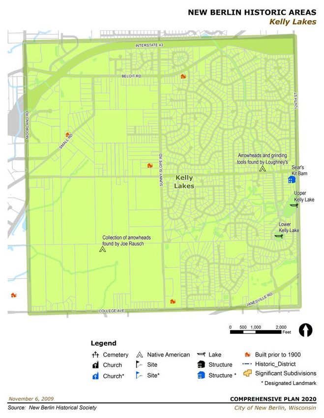
Mathias & Barbara Jungbluth. Designated a New Berlin Landmark
on June 8, 1993. It is no longer standing.
Lindsey-Murphy-Heinz-Sisson Farmstead (c. 1840) – Located at
20155 W Barton Road, this Cream City brick house was built by
Quincy Church. The farmstead was once owned by John Lindsey.
The Murphy's, whose sons operated a creamery, also owned the
house at one time. It was then owned by John Heinz and since
1970 the Lee Sisson Family. The Sissons donated the Creamery
(once the 1863 Prospect Hill School) to the Historical Park.
Linnie Lac Dam and Lake Site (c. 1836) – Located along College
Avenue. This is the site of Waukesha County's first sawmill,
waterpower, and dammed body of water built and operated by
Hugh Wedge and Isacc DeWitt in 1836. It was also the site of four
grist and flouring mills from 1837 – 1890s and was later known as
"Hales Millpond". Farmers from all over the county soon took
advantage of the mill operation, which supplied them with the
lumber needed to build houses and other structures. It also helped
to feed the area settlers with the corn and grains processed in the
grist and flouring mills. Designated a New Berlin Landmark on
February 22, 2000.
Nicolaus Victorian Farmhouse (c. 1900) – Located at 3655 South
Woelfel Road, the Victorian frame farmhouse and buildings were
built in 1900. David C. Nicolaus purchased the property in 1913
and it is still owned by the Nicolaus family today. Designated a
New Berlin Landmark on November 4, 1996.
Sears Kit Barn (c. 1920) – Located at 12415 South Grange
Avenue, It was built in the early 1920's and operated as a dairy
barn up until the middle 1940's. The exterior of the barn and milk
house is original (see Figure 4.3). According to the Sears Archives,
Sears offered pre-cut barns and other farm buildings through
special catalogs from 1911 through 1932. Other types of farm
Figure 4.3. Sears Kit Barn
buildings offered included corn cribs and granaries, hog houses,
poultry houses and milk houses. From 1911 through 1917 a few
barns were offered each year in the back pages of Sears Modern
Homes catalogs. Beginning in 1918, Sears issued special Barn or
Farm Building catalogs. Designated a New Berlin Landmark on
May 28, 2002.
4:6 New Berlin 2020 Comprehensive Plan
Tacl’s Tavern/Roadhouse (a.k.a. Asia Restaurant, c. 1927) –
Formerly located at 20401 West Greenfield Avenue, the building
was torn down with the widening of Greenfield Avenue in 2000.
Tacl's Tavern or Roadhouse was built in 1927 on the corner of
Johnson Road and Greenfield Avenue in the Town of New Berlin.
The American Roadhouse was prevalent in the United States
during the Prohibition and Depression eras of the 1920's and
1930's and is considered the foundation of the original "Mom and
Pop" family business. The American Roadhouse provided a life
style featuring residential living quarters for the family as well as a
source of income. Generally, the husband and wife would run the
business, often with the help of their children and other family
members. In many cases, the husband would maintain a full or Figure 4.4. Tacl’s Tavern/Roadhouse.
part-time job outside of the family business in order to supplement
the family income. Designated a New Berlin Landmark on April 19,
1994.
Additional designated New Berlin City
Landmarks:
First Freewill Baptist Church – designated November 7, 1989
Westin Apple Orchard - designated February 17, 1992
Prospect Hill School #3 (Sisson’s) - designated February 17, 1992
Meidenbauer Log House - designated February 17, 1992
Winton Sprengel House - designated February 17, 1992
Site of Winton’s Store & Post Office - designated February 17,
1992
Prospect Hill School #3 (Peterson’s) - designated February 17,
1992
1st Post Office on the Hill (Nedd’s) - designated February 17, 1992
First Freewill Baptist Church Parsonage - designated February 17,
1992
Lindsey-Murphy-Heinz Farm (Sisson’s) - designated February 17,
1992
Swartz Cornfalfa Farm– designated May 20, 2004
Calhoun & Calhoun Hamlet – designated September 16, 2004
Chappel Sports/Elger Store – designated June 9, 2009
Luthi Barn – designated June 9, 2009
Cheese Factory/Mustang Shelly’s Roadhouse – designated
December 18, 2014
Sunnyside Cemetery – designated November 21, 2013
New Berlin 2020 Comprehensive Plan 4:7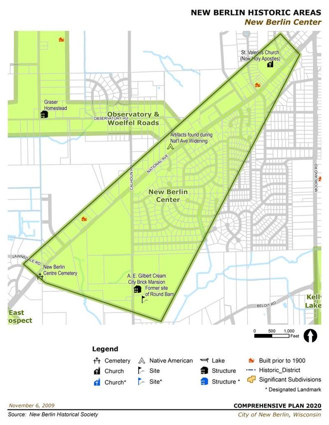
New Berlin Center Cemetery – designated November 21, 2013
William and Elizabeth Koeppen Home – designated April 8, 2014
Foster/Giesfeldt Home – designated December 18, 2014
4:8 New Berlin 2020 Comprehensive Plan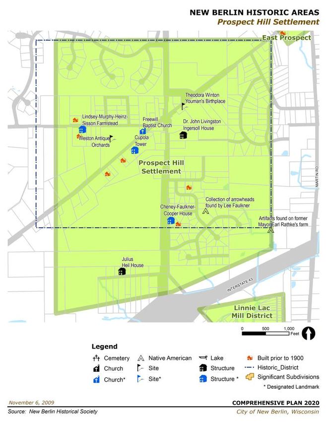
HISTORIC DISTRICTS
Cultural and historic resources throughout the City have been identified.
Please see Exhibit D for maps of each Historic District. Below is a list of
each potential Historic District. Per Chapter 141 of the Municipal Code,
a landmark or landmark site designation may be placed on any site,
natural or improved, including any building, improvement or structure
located thereon, or any area of particular historic, architectural or
cultural significance to the City, such as historic structures or sites
which:

 1.    Exemplify or reflect the broad cultural, political, economic or
                                                                              Figure 4.5. Calhoun Farms Subdivision.
       social history of the nation, state or community;
 2.    Are identified with historic personages or with important events
       in national, state or local history;
 3.    Embody the distinguishing characteristics of an architectural
       type of specimen, inherently valuable for a study of a period,
       style, method of construction of indigenous materials or
       craftsmanship; or
 4.    Are representative of the notable work of a master builder,
       designer or architect whose individual genius influenced his age.

Calhoun Farms – located south of Greenfield Ave. between Calhoun
Road to about 180th. Northwestern Railway is the southern border.
Part of the area is now Calhoun Farms Subdivision. Figures 4.5 and
                                                                              Figure 4.6. Calhoun Farms Subdivision.
4.6 show existing homes in the Calhoun Farms Subdivision.

In the era of the railroad, Calhoun was the busiest center New Berlin
has ever seen. The most important event in Calhoun’s history occurred
in early February 1882, when the Northwestern Railway pulled its first
train into the community. The station was built on George E. Calhoun’s
land and named after him; the road was named for the station rather
than the family. Another important event occurred in 1898 when the
Interurban Railway service or TM provided transportation to the city of
Milwaukee and much of southeast Wisconsin. The service continued
until June 30, 1951. The area is now the Waukesha County Bike Trail.
The TM was the nickname for the Interurban Railway service provided
by The Milwaukee Electric Railway and Light Co. (T.M.E.R. and L.).
Calhoun Hall, 1849 S. Calhoun Road, was once a postal station (Figure
4.7). It also housed a saloon and some sort of store as well. People
paid their taxes there and the Hall was also a roller skating rink and the

New Berlin 2020 Comprehensive Plan                                                                                 4:9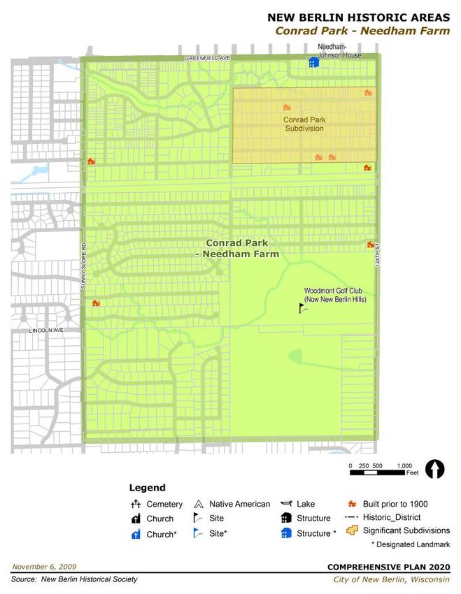
site of Tuesday night card games. The closing of the TM and decline of
                             the railroad changed old Calhoun forever.

                             Calhoun Farms Subdivision happened in the early 1940s. A ceremony
                             was held to dedicate two “Calhoun” markers located by the Waukesha
                             County Bike Trail on September 16, 2004. The event was sponsored by
                             the New Berlin Landmarks Commission. The markers were put in place
                             by the Waukesha County Historical Society. These markers pay tribute
                             to the significance of the era and Calhoun settlement. Calhoun
                             Homesteads, now Calhoun Farms Subdivision, was a planned
                             community with architecturally similar, low-lying, cottage houses, just
                             north of the railroad tracks and accessible from Calhoun Road. For its
                             time, it was a very special and attractive subdivision with unity in its
 Figure 4.7. Calhoun Hall.
                             variety and enough space to seem rural. It has retained much of its
                             charm with the white fences surrounding some of the properties.

                             Thomas Calhoun and his wife Mary were born in Ireland and bought a
                             piece of land at Calhoun Rd., and W. Greenfield Ave. in 1847. The
                             couple had two children, Mary and George. In 1900, George Calhoun
                             sold his farm to Col. Fred Pabst. There are still descendants of the
                             Calhoun family living in New Berlin.

                             Franz Elger also had a farm on Calhoun Road in 1852. He died in 1889
                             and his extensive property had to be divided among four sons. The
                             Elgers’ operated a store in about 1917 (Figure 4.8). Horse sheds were
                             in the back of the store for use by customers.

                             Col. Frederick Pabst of the Pabst Brewing Co. in Milwaukee purchased
Figure 4.8. Elgers’ Store.   the Calhoun farm as well as even more land on the west side of
                             Calhoun Road. Col. Pabst wanted a show farm for stock and raising of
                             hops for his brewery. Fred Pabst, Jr., sold the land to Dr. David
                             Roberts of Waukesha.

                             Dr. David Roberts was a state veterinarian in 1906-1908 and
                             manufacturer of cattle medicine. He peddled his veterinary supplies
                             from a medicine wagon drawn by a yoke of buffalo. Roberts’ barn was a
                             model well ahead of its time with concrete floor, cork stanchions and
                             electricity supplied from its own dynamo.

                             Conrad Park – Needham Farm – the City’s first Subdivision was
                             recorded in 1913. The original house, built in 1868, is on the National

                4:10                                              New Berlin 2020 Comprehensive Plan
Register of Historic Places. Located in the extreme northeast corner of New Berlin, it is bounded on the north by Greenfield Ave., on the east by County Line Road (124th St), and on the west by Sunny Slope Rd. Figures 4.9 and 4.10 illustrate an existing road and home in the Conrad Park Subdivision. It was the first subdivision in New Berlin, deriving its name from West Allis businessman, Otto Conrad, who purchased the Needham woods in late 1912 for real estate development. Vital to this subdivision’s success was the interurban electric rail line, which bisected the area and provided easy access to workers from Allis Chalmers at its Woodmont/County Line (124th St) stop. From the beginning, Conrad Figure 4.9. Conrad Park Subdivision. Park was aimed at this blue-collar group, with the first house lots sold prior to World War I. Woodmont Country Club, begun in 1907 with the purchase of its original 40 acres in Section 1 from Daniel Ewers, became the first commercial recreational development in the community. By 1926, many acres had been added along with private cottages and a clubhouse, but in part due to aging membership and financial difficulties during the Depression, the club was eventually sold in 1943 to a group of West Allis businessmen and reopened as Lincoln Hills. In 1954, another transition occurred with the purchase of the course by Allis-Chalmers. The course was renamed the W.A. Roberts Golf Course shortly afterwards in memory of the President of Allis-Chalmers following his Figure 4.10. Conrad Park Subdivision. death. In the Roberts era, the Woodmont summer cottages, except the clubhouse, were torn down. In 1978, the City of New Berlin purchased the golf course and changed its name to New Berlin Hills. In 1999 a new clubhouse was completed under the management of Crown Golf Management. Having celebrated its 100-year anniversary in 2007, its inception as Woodmont Country Club stands as one of the oldest golf courses in the state. Among the many fine homes of Conrad Park, a notable Landmark is the Needham-Johnson house, at 12713 W. Greenfield Ave. It was built in 1868 with the stones comprising the exterior quarried from local pink stone. The Italianate cut-stone Needham house is on the National Historic Register of Historic Places, as well as a Landmark of the City of New Berlin. The land that the home stands on was originally purchased by Enoch Gardner Needham in 1842. The home replaced an earlier log cabin and has been continuously lived in by descendants of the New Berlin 2020 Comprehensive Plan 4:11
Needham-Johnson families since 1868. The Johnson family is the
                                              family for whom the Johnson Road in western New Berlin is named.

                                              Prospect Hill & Lower Prospect Hill – this area is located near the
                                              intersection of Racine Avenue and National Avenue. It was the biggest
                                              settlement in New Berlin Township. Please see Exhibit C for maps and
                                              brochures of this area and a map of Prospect Hill from 1853.

                                              The area near National & Racine Ave. was the center of the old Yankee
                                              Settlement named Prospect Hill by Dr. John Ingersoll. It was the site of
                                              one of the earliest settlements in New Berlin Township. Prospect Hill
                                              was a close-knit hamlet at the turn of the century. Its 200 residents
                                              operated their mills, blacksmith and cooper shops, tree nursery and
                                              greenhouse. Among them were a doctor, minister, surveyor, carpenter,
                                              well digger, dressmaker, mason and teacher. After World War I, the
                                              Model “T” took folks away from home and rural free delivery closed the
                                              local post offices and the little stores died. The intersection once held a
                                              gas station, large home and an implement dealer. Situated south
                                              Racine Avenue, along Shields Drive, was the City’s first post office and
                                              a parsonage. These buildings were removed to make way for the
                                              rebuilding of Racine and National Avenues. Some buildings have been
                                              moved and restored in the Historic Park. Except for buildings in the
                                              park the rest are privately owned and include the first Freewill Baptist
                                              Church in Wisconsin along with the Weston Antique Orchards, both of
                                              which are on the National Historic Register of Historic Places. Adjacent
                                              to the Westin Orchard is the Lindsey-Murphy-Heinz-Sisson house which
                                              is also a New Berlin Landmark home.
Figure 4.11. First Freewill Baptist Church.

                                              The Freewill Baptist Church was the first in the state of Wisconsin
                                              (Figure 4.11). The architecture of the Freewill Baptist Church has been
                                              restored to that of the mid-1800’s, and represents classic New England
                                              meeting house design. Prospect Hill was also the childhood home of
                                              Theodora Winton Youmans, nationally known news reporter and
                                              suffragette.

                                              The Weston Antique Orchards are the home of many varieties of
                                              antique apples, dating back several centuries. The entire District was
                                              given historic status on November 19, 1991.

                4:12                                                                New Berlin 2020 Comprehensive Plan
Figure 4.12. Winton’s General Store.
The Church/Winton General Store and Post Office and hall were
located on Prospect Hill (Figure 4.12). Daniel Church was the first
postmaster of the Prospect Hill Post Office in 1850. In 1860, the
Winton’s operated it as a General Store and Post Office. The building
was moved to Racine Avenue, just south of National Avenue from its
original location at 19425 W. National Avenue. Later it was owned by
James E. Need. When he died his estate was handled by his brother,
Mr. Anthony Need, and in 1993 was sold to Shawn DePetro who
occupied it for 13 years. It has been torn down for the widening of
Racine Avenue.
Prospect Hill School #3 is located at 5545 S. Racine Avenue and was
the fourth site of Cheney and Prospect Hill Schools. It was the only
school with a belfry and basement. It was designed and built by Elden
Faulkner and Jacob Graser. It remained a school until 1953. It is now a
private residence.
The Dr. John Livingston Ingersoll House is located at 5530 S. Racine
Avenue. Dr. Ingersoll gave Prospect Hill its name and married the
Figure 4.13. Sign for Governor Julius P. Heil Home.
pastor’s granddaughter, Theresa Cheney. His brother, Colonel Robert
New Berlin 2020 Comprehensive Plan 4:13Green Ingersoll, was the world renowned orator and agnostic who often
visited here. Dr. Ingersoll was not the only doctor in the area. Dr.
Ingersoll had three sons who lived less than one year.
The parsonage was built in 1886. This was the same year the Prospect
Ladies Aid Society was organized and raised funds to keep the church
active. This house was unusual as it was built at a right angle to the
road. There are only two or three homes on the hill that can say this.
After the church was closed in 1925, the parsonage became the Smith
house around 1925. It has been torn down to make room for the
widening of Racine Avenue.
The Cheney-Faulkner-Cooper House (Figure 4.14) is located at 5810 S.
Racine Avenue and was built in 1840. Wisconsin’s First Freewill Baptist
Church Congregation was formed in the parlor of this house on July 11,
Figure 4.14. Current Photo of Cheney-Faulkner-Cooper 1840. It was Rev. Rufus Cheney who established the Freewill Baptist
House. Congregation at the south slope of Prospect Hill. The Prospect Hill
School was also founded in this house. It was designated a New Berlin
Landmark on December 9, 1997. The house is now occupied by Glen
and Karen Cooper.
The Julius P. Heil house (Figures 4.13 and 4.15) is located at 19890
Julius Heil Drive and was built in 1849. This is the childhood house of
Julius Paul Heil, 1876 – 1949. Mr. Heil was a German immigrant boy
who grew up at the foot of Prospect Hill. He and his brother gathered
fieldstone to build their house. Julius became a two-term Governor of
Wisconsin in spite of his fourth grade education. The kickoff for his
Figure 4.15. Current Photo of Julius Heil House. campaign for Governor began at Prospect Hill.
The Martin-Johnson house (Figure 4.16) is located at 5615 S. Racine
Avenue and is the oldest remaining house in New Berlin. It was built in
1836 by John H. White and was later owned by T. S. Winton, who was
the father of women’s suffragist, Theodora Winton Youman. Later it
became known as the John Martin house and is presently owned by his
sister, Betty Johnson. The house was built in 1836 with a fieldstone
foundation, all wood, and shingle siding. The outline of the Greek revival
architecture is visible. This house is located across from the Cheney-
Figure 4.16. Current Photo of Martin-Johnson House.
Faulkner-Cooper house.
East Prospect – located along National Avenue at the intersection of
Martin Road & Beloit Road.
4:14 New Berlin 2020 Comprehensive PlanThis area included a dance hall, country store, hotel and sulky track, all
of which provided social reasons for locals to gather in the late 1800’s
and early 1900’s. There was also a creamery. Milk was an important
local product and, in 1879, New Berlin’s butter production was the fourth
largest in the county. The Strand Hotel, which is no longer standing,
was a restaurant and stopping place for travelers between Milwaukee
and Mukwonago
Elger’s Red Bell Market (currently Chappell Sports, 18600 W. National
Figure 4.17. Elger’s Red Bell Market.
Avenue) is a wood frame building, essentially unchanged since it was
built in 1888 (Figure 4.17). Their family-owned market operated for
nearly 70 years (1909-1977).
The creamery (currently Mustang Shelly’s, 18540 W. National Avenue)
is a two-story fieldstone building, essentially unchanged since the late
1800’s (Figure 4.18).
Peck’s Dance Hall and Saloon (currently the Richdorf Apartments,
18000 W. National Avenue) originally wooden, is now a two story brick
edifice (Figure 4.19). The tall end of the building was where the dance
floor was located.
Kelly Lakes – an area in the southeast corner of the City that contains
the only natural lakes in New Berlin.
Figure 4.18. Current Photo of Mustang Shelly’s, former
Creamery.
The Southeast corner of New Berlin was populated following 1836 by
families of Irish descent, who owned more than four sections or four
square miles near Beloit & Small Roads and Grange & College
Avenues. They arrived in the area via two trails that crossed this area
from Milwaukee, the original Beloit Road and Janesville Road. St.
Mary’s Roman Catholic Church at Hales Corners was the area’s church.
Family names from the time are still heard in New Berlin today,
including Kelly, Kerwin, McGowan, Murray, Riley, Quade, Small,
Malone and Killips, to name a few. Grange Avenue was originally
known for many years as Irish Road. In 1839, Peter and Felix Kelly Figure 4.19. Current Photo of Richdorf Apartments, former
came and settled along Grange Avenue, just west of Sunny Slope Peck’s Dance Hall.
Road. They later owned and operated a farm in the area of 124th and
Grange Avenue, now known as the area of Upper and Lower Kelly
Lakes. The lakes were originally known as Mud Lake (Upper Kelly
Lake) and Big and Little Lakes. The smaller lake is rumored to be
New Berlin 2020 Comprehensive Plan 4:15bottomless because the story is that an anchor dropped 300 ft. did not
touch bottom. These are the only natural lakes in New Berlin. The
Kelly brothers also harvested ice that was stored in a large icehouse
behind 12401 W. Grange Ave. They also rented boats to fishermen,
and swimming was common. The area is significant due to its cultural
representation of one of New Berlin’s historic ethnic groups, those of
Irish descent (see Figures 4.20 and 4.21).
Linnie Lac Mill District – The Linnie Lac Mill District was formerly
called Hales Mill Pond and was the first dammed body of water in
Waukesha County. It was also the site of the first sawmill (1836)
operated in the county. Eventually there were four Mills on the lake that
Figure 4.20. Home near Kelly Lake.
used its waterpower to operate saw, grist and flouring Mills. The area
was once known as Cob Town because of all the corncobs around the
mill. The mills spurred development, and in the 1920’s, John Blott
subdivided the shore and renamed it Linnie Lac after his wife Malina
(Linnie). Around 1840 to 1850, a Post Office operated in the area,
called Muskego Mills. Today there are 30 lake front lots, 14 in the
cattail area and 25 others, consisting of small bungalow-type homes
from the 1930’s. Some have since been updated. In June 1997,
flooding threatened the dam and the Wisconsin Department of Natural
Resources dug a trench around it to avoid flooding downstream in
Muskego. Since no owner could be found, the homeowners formed the
Linnie Lac Management District and took over ownership of the dam
Figure 4.21. View of Kelly Lake from Existing Trail. and worked out a taxing system to repair the dam. Completed in 2000,
the dam was declared a New Berlin Landmark on February 22, 2000
(see Figures 4.22 to 4.25).
Figure 4.22. Linnie Lac Area (view looking west).
4:16 New Berlin 2020 Comprehensive PlanFigure 4.23. Linnie Lac Area (view looking north-west). Figure 4.24. Linnie Lac Area (view looking north).
Figure 4.26. Stigler Nature Preserve
Figure 4.25. Linnie Lac Historic Marker
New Berlin 2020 Comprehensive Plan 4:17Stigler Nature Preserve – located west of Calhoun Road and north of
Cleveland (Figure 4.26).
This site is currently a park owned and managed by the City of New
Berlin. The park contains walking trails and a bike path. In the early
1840’s there had been an Indian campsite known as the Poplar Creek
Campsite that contained, at times, 150 – 200 Indians. By the early
1850’s the site had ceased to be used, nearly 20 years after white
settlement had arrived in the area, including the Stanhope and Elger
families on nearby Calhoun Rd (see Lincoln Avenue notes regarding
Indian burials and twin mounds). During the time that this property was
owned as a farm by the Stigler family, the Stiglers and others had
extracted Indian bones. This site and the Lincoln Avenue site, was also
visited by the State Archeologist in 1903, at which time the history of the
area pertaining to native peoples was documented. It is believed that
the Native Americans at the Poplar Creek Campsite may at one time
have been Menominee, but at the time of white settlement at least some
of the Indians may have been Potawatomi, the dominant tribe in the
county at that time.
Observatory Road – near the intersection of Woelfel Road and
Observatory Road, following Woelfel Road to the north.
Observatory Road is a winding, scenic road running through the west
side of New Berlin, at one time it was a great place to grow potatoes
Figure 4.27. Observatory Road Photos. (Figure 4.27). Migrant workers from Mexico came for work at harvest
time and lived in houses on the land. The Graser homestead was
established in the mid-1800’s and is still standing on the corner of
Observatory and Woelfel Roads.
Observatory Road is also notably home to the Milwaukee Astronomical
Society and has been since 1937 when they constructed a small roll-off
shed on a three-acre hilltop. The observatory has grown over the years
with more buildings, and has also developed into a research facility for
members to enjoy. The public is also welcomed to several open houses
throughout the year on specified dates.
Adjacent to the Observatory Road is the Woelfel Road settlement, an
extension of the Coffee Road German cultural settlement, located to the
north. Several structures along Woelfel Road are significant as
4:18 New Berlin 2020 Comprehensive Planrepresentations of Victorian farmhouse architecture and include the
following properties:
Roger Woelfel Farm—Cream City Brick Farmhouse
David Woelfel—separate farmhouse on Woelfel Road
Ken Woelfel—separate farmhouse on Woelfel Road
Cooper Tree Farm—direct relationship to the Woelfel family (Randy
Cooper’s wife is a Woelfel)
Nicolaus Farm (Figure 4.28)—Built in 1900 by local carpenters, the
Victorian-style farmhouse typifies the era. The land is still being
farmed and is home to horses and chickens. This became a
Landmark property of the City of New Berlin November 14, 1996. Figure 4.28. Photo of Nicolaus Farm.
Historic Coffee Street & Cornfalfa Farm – currently known as Coffee
Road, it was a one track gravel road that passed through a
neighborhood of Little Grove School District.
This area represents a unique German cultural settlement within the
historic New Berlin community. Initially comprised of two wheel ruts
with grass between and brush on both sides, Coffee Street derived its
name from farmers who hauled their milk to the depot at Calhoun Road.
The aroma of coffee filled the air as they passed each home, thus the
lane became known as Coffee Street. Some of the Coffee Street
neighbors included the Baumgartner, Graser, Hause, Koeffler, Faulkner,
Meidenbauer, Kern and Swartz families. The Grasers’ log cabin still
stands, covered with siding at Coffee and Wehr Road. Cari-Adams
subdivision was named in honor of the Grasers’ parents Adam & Carrie
Graser.
Many activities of the Coffee Street neighborhood took place at the
Swartz Cornfalfa Farms, located west and south of Coffee Street, on
500 acres at Swartz Road and Racine Avenue (Figure 4.29). Five
acres of the property were set aside for picnics for the surrounding
neighbors. The cream city brick church parsonage and cemetery were
German Reform and their little one room school was the Little Grove
School. For the last day of school the parent-teacher association would
set up entertainment. One of the entertainers asked to sing was Lester
Polfuss, later known as Les Paul. Figure 4.29. Cornfalfa Farms Orchards.
The famous “Cornfalfa” Swartz Brothers farm of 500 acres, at one time,
had six large barns and as many smaller outbuildings and sheds. Each
New Berlin 2020 Comprehensive Plan 4:19of the six barns had a specific purpose; they housed the many horses,
cattle, sheep and pigs that were needed for the farm operations. The
buildings were also used for storage of wagons, tractors and farm
machinery as well as for storing the large harvest of corn, alfalfa, hay,
wheat, oats and apples, which the Swartz’s were so well known for.
Cornfalfa Farms was also famous for raising the internationally known
Asiatic Karakul sheep, used in the making of expensive black fur coats.
Between World Wars I and II, Swartz’s Cornfalfa Farms was a national
producer of apples due to their perfection of the apple varieties they had
been growing for three generations. Today, six of the buildings from the
original farm are still standing and are part of Minooka Park, in
Waukesha County’s Park system. Cornfalfa Farms represents a
significant era in New Berlin’s past, when farming was the predominant
occupation of most residents of the township. Cornfalfa Farms
achieved national significance due to the Asiatic Karakul sheep and
also the apples that contributed to the nation’s food supply between the
World Wars.
New Berlin Center – located along National Avenue between
Lawnsdale Road and Holy Apostles Church. This area was a
commerce hub and the location of the Town Hall (Figure 4.34).
Figure 4.30. New Berlin Cemetery along National Avenue.
In the earliest years of settlement, National Avenue had blacksmith
shops, taverns, hotels, schools and a cemetery. At the intersection of
Lawnsdale Road and National Avenue (originally an Indian trail) is one
of New Berlin’s oldest cemeteries, started in 1841 (Figure 4.30). Laid to
rest there are many of the city’s earliest “movers and shakers.” The
New Berlin Center Cemetery shelters the graves of pioneer aldermen,
shopkeepers, postmasters, the city’s first teacher, large landowners,
Civil War veterans, a State Assemblyman and a murder victim. The
city’s first school, New Berlin Center School, was at Calhoun Road and
National Avenue (Figure 4.31). The first town hall stood on land near
the present day City Hall. Casper’s Inn (now Asia House) was a local
Figure 4.31. New Berlin Center School.
gathering place beginning in 1858. St. Valerius (present day Holy
Apostles) is the city’s oldest church, started in 1844. Holy Apostles was
first a log church, then white frame, then two-story brick with a 134 foot
steeple and has been in its present design since its dedication in 1967.
Bernard Casper built a sidewalk from his inn to St. Valerius for his
daughter’s wedding. This fact made ‘Ripley’s Believe It Or Not’ as it is
the only sidewalk connecting a church and a saloon.
4:20 New Berlin 2020 Comprehensive PlanOn Albert Schroeder’s farm located along Calhoun Rd. (also the site of
the round barn) the first rubber tires ever put on a tractor were used
experimentally by Allis Chalmers and Firestone Rubber Co. (1932); they
lasted 14 years. This tractor is on display in Cassville, WI at the farm
museum.
A. E. Gilbert first came to New Berlin as a boy in 1839. He was Town
Chairman in 1885. He built a two-story, cream city brick “mansion” on
Calhoun Road (Figure 4.32).
New Berlin’s famous round barn (on Calhoun Rd. ¼ mile north of Beloit
Figure 4.32. A. E. Gilbert Mansion.
Rd.) is no longer standing (Figure 4.33). It was built in 1898 and was
the only such structure in Waukesha County. The silo (which is still
standing) went up the middle and the stalls on the lower level were
arranged like spokes on a wheel.
Lincoln Avenue Log Road – located west of Calhoun Road and 179th
Street up to Johnson Road.
The area including Lincoln Ave and extending south on Calhoun Rd.
has been known historically as the area of the great New Berlin
tamarack swamps (Percy Elger, 1929). Due to the extreme wetness of
the area and how it affected roads in several of the lowest spots, there
were at least two locations where “corduroy roads” were part of the
roadway. A corduroy road was a road made of logs placed side by side
across the road without nails, which provided a bumpy ride but one
without the risk of being mired in the mud. Corduroy or log roads
served a unique function in pioneer days as a means of allowing people
to travel through areas with excessively moist roadways. As such, they
were vital in developing the township of New Berlin as we know it today.
Lincoln Avenue was originally known as Rabbit Lane, Rabbit Road and
Tamarack Road due to the use of tamarack logs in the log road portion
of the roadway. The name was changed to Lincoln Avenue following
the late 1950’s. A literary account entitled “A Country Chronicle” by G.
Showerman indicates that a corduroy road existed in the area around
the railroad tracks on Calhoun Road, and possibly also near the current
intersection of Coffee Road and Calhoun Road. Roadwork in the area
of West Lincoln Avenue in the 1980’s and 1990’s uncovered portions of
a log road in that vicinity also. The unique moisture and soil
New Berlin 2020 Comprehensive Plan 4:21composition of the area made the west Lincoln Avenue a good place for
commercial sod farming.
Additionally, the area is historically significant due to the discovery of six
Native American burials in the SW ¼ of the NE ¼ of Section 9, 18901
W. Lincoln Ave. during a 1990’s excavation by utility crews. Verification
from the State Archeologist’s office indicates that the remains represent
persons of the late Woodland period, from 500 to 1000 years ago. They
were determined to be Menominee in origin. A late Woodland or
Hopewell date would establish burials in the same time frame as the
twin mounds that were described in 1903 by State Archeologists visiting
the former Stanhope farm, about a half-mile away, since such mounds
were characteristic of that period. The two small conical Indian mounds
were known in Dr. Charles Stanhope’s boyhood growing up on his
Figure 4.34. New Berlin Town Hall. father’s farm on the east side of the Calhoun Rd. Over time they were
obliterated by cultivation.
Future Plans to Protect and Promote Historic Sites – Strategies to
Carry-out the Goals
The Landmarks Commission will continue to work to promote historical
and cultural awareness throughout the City. Signs and/or informational
plaques should be placed at each designated site and district to notify
and inform the public of the resource. The Commission should continue
to promote New Berlin’s Historical Days and work in conjunction with
the New Berlin Historical Society to meet the goals of the Commission.
Recommendations
The Landmarks Commission should continue to maintain and
update the list of historic districts and cultural resources.
o Follow procedures set forth in Chapter 141 of the Municipal
Code for any historic designations.
Increase public awareness of New Berlin’s cultural and historic
resources.
o Prepare signage for designated sites.
o Continue to promote and be involved in the annual Historic
Days.
o Create a driving tour/brochure of New Berlin’s cultural
resources and historic districts.
Encourage a proactive Landmarks Commission
o Set goals and priorities each year for Landmarks Commission
accomplishments.
4:22 New Berlin 2020 Comprehensive Plano Continue ongoing projects to educate the community regarding
New Berlin’s cultural resources and districts.
Landmarks Commission should continue to work with and support
the New Berlin Historical Society.
o Share resources with one another.
New Berlin 2020 Comprehensive Plan 4:234:24 New Berlin 2020 Comprehensive Plan
New Berlin 2020 Comprehensive Plan 4:25
4:26 New Berlin 2020 Comprehensive Plan
New Berlin 2020 Comprehensive Plan 4:27
4:28 New Berlin 2020 Comprehensive Plan
New Berlin 2020 Comprehensive Plan 4:29
Exhibit D – Historic District Maps
The following maps are included with this Exhibit:
New Berlin Historic Areas – overall map of the entire City
Calhoun Farms
Conrad Park – Needham Farm
Prospect Hill & Lower Prospect Hill
East Prospect
Kelly Lakes
Linnie Lac Mill District
Stigler Nature Preserve
Observatory Road
Historic Coffee Street & Cornfalfa Farm
New Berlin Center
Lincoln Avenue Log Road
4:30 New Berlin 2020 Comprehensive PlanNew Berlin 2020 Comprehensive Plan 4:31
4:32 New Berlin 2020 Comprehensive Plan
New Berlin 2020 Comprehensive Plan 4:33
4:34 New Berlin 2020 Comprehensive Plan
New Berlin 2020 Comprehensive Plan 4:35
4:36 New Berlin 2020 Comprehensive Plan
New Berlin 2020 Comprehensive Plan 4:37
4:38 New Berlin 2020 Comprehensive Plan
New Berlin 2020 Comprehensive Plan 4:39
4:40 New Berlin 2020 Comprehensive Plan
New Berlin 2020 Comprehensive Plan 4:41
4:42 New Berlin 2020 Comprehensive Plan
You can also read