Chinese Mass Nature Tourism and Ecotourism
←
→
Page content transcription
If your browser does not render page correctly, please read the page content below
Chapter 7
Chinese Mass Nature Tourism
and Ecotourism

1 Introduction

Building on the discourses of the “politics of land-use planning” and “frontier resour-
cification” examined in Chap. 4, this chapter features two strategic planning proposals
that engage the ideological and practical frictions between Chinese mass nature
tourism and ecotourism.
    Mass nature tourism is a model employed by China’s southwestern frontier
provinces such as Yunnan since the early 2000s (Zinda, 2014). Conceived and imple-
mented as part of the Chinese central government’s long-term Great Western Devel-
opment Strategy launched in 2000 that aims to raise economic standards in western
China, mass nature tourism is a development tool for some of the most remote frontier
regions characterized by “adverse” natural conditions, “underdeveloped” infrastruc-
ture and a largely “impoverished” population (State Council of the People’s Republic
of China, 2000). Mass nature tourism is driven by an economic ideology that appro-
priates an “impoverished” region and its population as resources for development
in the name of poverty alleviation, with tourism zoning carried out based on the
suitability of land for natural and cultural commodification.
    In recent years, the Chinese model of mass nature tourism has been introduced,
in parallel with other types of economic development, into northern Laos, notably
within the country’s newly established Special Economic Zones (SEZ) (Figs. 1, 2, 3
and 4). For example, Chinese and Lao mainstream media are promoting Boten and
Luang Prabang, two of Laos’s major tourist attractions and key stations on the China-
Laos Railway, as examples of the “international modern new town with outstanding
natural and cultural landscape” (Investvine, 2019; Lao National Television, 2016;
Ta Kung Pao, 2019). A ten-fold increase in tourist numbers is projected on comple-
tion of the China-Laos Railway.1 The new town or SEZ plans of Boten and Luang
Prabang both set out a spatial order maximizing the commodification of nature and

1Authors’ conversation in March 2018 with members of Luang Prabang’s network of hospitality
management.

© The Author(s) 2021                                                                   159
A. S. Kelly and X. Lu, Critical Landscape Planning during the Belt
and Road Initiative, https://doi.org/10.1007/978-981-16-4067-4_7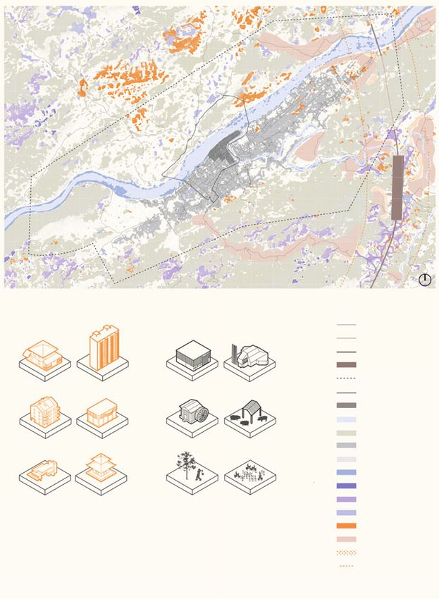
160                                             7 Chinese Mass Nature Tourism and Ecotourism

culture, where tourism and resort zones include existing natural rivers and local
ethnic villages as well as newly constructed artificial lakes and cultural demonstra-
tion villages (Architectural Design & Research Institute of SCUT, 2016; Planning
& Design Center of Haicheng Group, 2018).
    These large-scale tourism programs being rapidly implemented in Laos may
arguably prove economically viable but unavoidably raise ethical, cultural and envi-
ronmental questions that call for urgent attention (See, for example, Hall & Ringer,
2000; Travers, 2008; Kyophilavong et al., 2018). The two strategic planning proposals
included in this chapter are: Negotiating with ethno-ecology: Landscape management
strategies for northern Laos’s ecotourism boom; and Living heritage: Redefining
protections for urban expansion in Luang Prabang. Focusing on Boten and Luang
Prabang respectively, these two proposals challenge an economic-driven and object-
based mass nature tourism model and investigate the possibility of a site-, culture-,
and landscape-sensitive ecotourism approach. Both proposals begin with an analysis
of the spatial and temporal patterns of key landscape systems such as the watershed,
food-shed, waste-shed and viewshed that are crucial for enabling the establishment of
tourism programs and for sustaining the local livelihoods and cultural practices that
are indispensable assets of authentic cultural landscape experiences. Based on these
analyses, both projects identify site-specific tourism development capacities, guiding
the scale and speed of development to minimize conflict between local communities
and tourism, while maximizing tourism-related ecological and social benefits.

Fig. 1 The deserted Golden Boten City (GBC), a former casino boomtown on the China-Laos
border, has experienced rapid transformation since 2016. This photograph was taken from the older
quarter of the GBC, once home to several restaurants serving exotic and endangered wildlife, toward
the Boten Special Economic Zone’s “twin-towers” in the newly established central business district.
Photo by Xiaoxuan Lu (March, 2019)
1 Introduction                                                                               161

Fig. 2 Speed of construction within the Boten Special Economic Zone has accelerated since the
inauguration of the Lao section of the Yunnan-Singapore railway, commonly called the China-
Laos Railway. This photograph captured the ongoing construction and large-scale leveling of the
landscape throughout the zone. Photo by Xiaoxuan Lu (March, 2019)

Fig. 3 Hot-air ballooning is increasingly popular in Vang Vieng, a small town on the Nam Song
river surrounded by some of Laos’s most iconic karst limestone mountains, located approximately
halfway between Vientiane and Luang Prabang. Anticipating the opening of the railway, the current
Lao tourism boom not only generates revenue and employment but unprecedented pressure on both
urban and natural environments and local livelihoods. Photo by Xiaoxuan Lu (March, 2018)
162 7 Chinese Mass Nature Tourism and Ecotourism
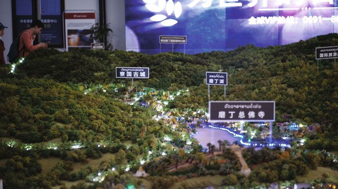
Fig. 4 According to its main developer, Haicheng Group, the Boten Special Economic Zone will
become a China-ASEAN tourist hub with sufficient capacity to cater to an expected 25 million
people once the China-Laos Railway is completed in 2021. This photograph shows the 1:1,000
panorama model on display at the Boten Exhibition Center, marked with the locations of the newly
planned “Ancient Lao City,” “Boten Lake,” and “Boten Central Buddhist temple.” Photo by Brian
Cheang (March, 2019)
2 Negotiating with Ethno-Ecology: Landscape
Management Strategies for Northern Laos’s Ecotourism
Boom
Considering the rapid growth of ecotourism in northern Laos and the often-negative
impacts of tourism development on indigenous communities, this project deploys
ethno-ecology as a tool to negotiate with tourism developers for the protection and
territorial integrity of cultural landscapes. Without critical awareness, the tourism
planning process often reduces indigenous peoples to primitive caricatures and
replaces local culture with homogenized cultural representations (Salazar, 2009).
In response to mainstream practices in the region, this project advocates for an
understanding of local knowledge via ethno-ecology, advancing alternative metrics
of cultural and ecological value and mechanisms for landscape management.
Ethno-ecology is defined as the organizational and cognitive relationships that
each local culture has with its non-human environment (Prado & Murrieta, 2015).
While ethno-ecology suggests a value system to be protected, it is also an adaptive
system capable of determining the capacity of the landscape to accommodate new
people and new programs, even including the substantial pressures for mass tourism
development in southwestern China and northern Laos. Nuanced and bespoke calcu-
lations of local “livelihood-sheds,” such as viewshed and foodshed, are used in this
project to understand, illustrate, and advocate for the spatiotemporal patterns of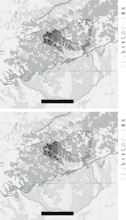
2 Negotiating with Ethno-Ecology: Landscape Management Strategies … 163
humans in their environment. Two villages in southwestern China and two villages
in northern Laos are deployed as testing grounds for exemplifying the diversity of the
ethno-ecology in the China-Laos border region and the impacts induced by tourism
development (Figs. 5, 6 and 7).
In southwestern China, Mandan village of the Dai people and Qingkou village of
the Hani people have confronted tourism development over the past several decades
and reveal the processes of exclusion and fragmentation embedded in mainstream
tourism planning (See, for example, iSkytree Tourism Planning, 2013; Sina, 2015;
Guipu, 2016; Liu & Ye, 2019). Despite focusing on different aspects of ethno-
ecology, both cases exhibit the intertwining of local spiritual and agricultural prac-
tices in generating the cultural landscape. Tourism planning here has greatly over-
simplified each village’s cultural realms and excluded large swaths of their cultural
territories because of object-oriented and profit-driven rationales (Figs. 8, 9, 10, 11,
12 and 13).
Insights drawn from these two ecotourism villages in southwestern China are then
translated to Boten and Nalan villages in northern Laos, both under tourism devel-
opment pressures from Chinese and Thai capital.2 Such translation helps predict
potential damages to the integrity of cultural landscapes and helps devise landscape-
oriented and culture-driven means of negotiation with investors and tourism plan-
ners. In the case of Boten village, now within the rapidly developing Boten Special
Economic Zone, its historical salt production system is a renowned local tradition
and highlight in the current tourism plan (Planning & Design Center of Haicheng
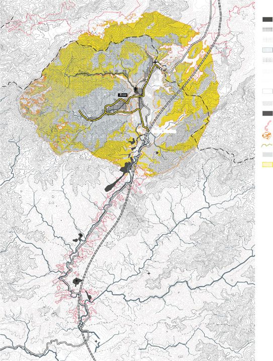
Group, 2018). This village is strategically selected for its potential in calculating and
visualizing Boten’s cultural territory and ideal tourism capacity (Figs. 14, 15, 16, 17,
18 and 19). In the case of Nalan village, its system of rice and rice wine production is
a cultural practice strategically chosen here for the quantification and visualization of
a cultural territory closely tied to the practice of shifting cultivation. Nalan partially
falls within the Nam Ha National Protected Area, and shifting cultivation is one of
the most misunderstood and controversial forms of land use (Figs. 20, 21, 22, 23 and
24) (Ducourtieux et al., 2005).
Indigenous practices and tourism development are not necessarily exclusive to
one another. An adaptive landscape that caters to traditional practices and tourism
programs can allow visitors to experience authenticity while securing the dignity and
strengthening local people to shape and maintain their cultural landscapes.
The design proposal “Negotiating with ethno-ecology: Landscape management
strategies for northern Laos’s ecotourism boom” and accompanying illustrations
were developed by Yani Zhang Mengting and William Wei Gongqi during the course
Studio Laos: Strategic Landscape Planning for the Greater Mekong.
2Author’s conversation in March 2019 with manager of Boten Special Economic Zone Planning
Exhibition Center.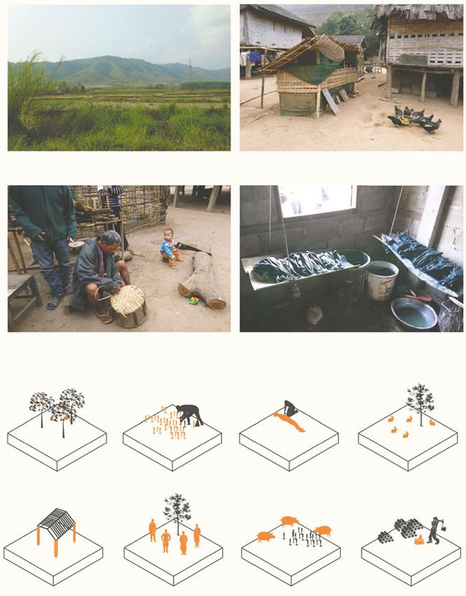
164                                                   7 Chinese Mass Nature Tourism and Ecotourism

Fig. 5 Two villages in
southwestern China and two
villages in northern Laos are
deployed as testing grounds                                                                       ay
                                                                                              ssw
                                                                                           pre
for exemplifying the                                                    ing
                                                                            -Ba
                                                                               ngk
                                                                                   ok
                                                                                        Ex

                                                                      nm
diversity of the                                                   Ku

ethno-ecology in the
China-Laos border region
and the impacts induced by
tourism development
                                                                                                                     Yuanyang

                                                                                                       Qingkou Village
                                                                                                       Hani People

                                                                  YUNNAN (CHINA)

                                                                  LAOS                                     VIETNAM

                                             Mengla

                                                         Mandan Village
                                                         Dai People

                                                          Boten Village
                                  Luang Namtha
                                                          Tai People
                                                                   Ch
                                                                      ina

                                Nalan Village
                                                                          -La
                                                                             os
                                                                            Ra

                                Khmu People
                                                                              ilwa
                                                                                  y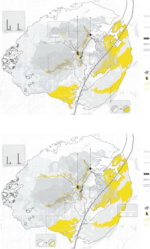
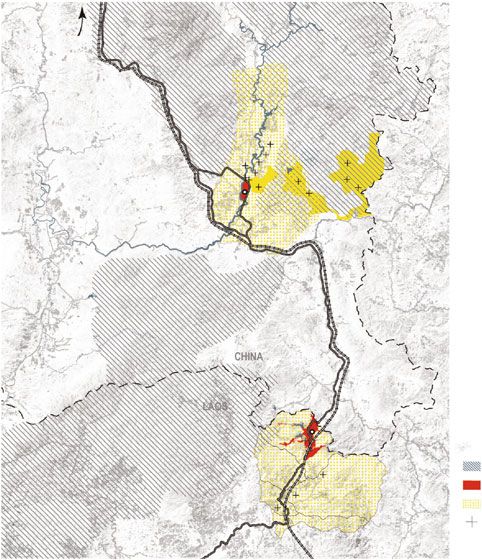
2 Negotiating with Ethno-Ecology: Landscape Management Strategies …                      165

Fig. 6 Mandan village and Boten village are both situated within development enclaves in the
China-Laos borderlands, namely Mengla-Mohan Key Development and Opening Up Experimental
Zones in China and Boten Beautiful Land Special Economic Zone in Laos

Fig. 7 Mengla and Boten are branded as the “Golden Crossroads of Five-Country Collaboration,”
and this map represents an imagined geography of the China-Laos-Myanmar-Thailand-Vietnam
economic regional affiliation promoted by the BRI
166                                              7 Chinese Mass Nature Tourism and Ecotourism

Fig. 8 Focusing on fengshui woodlands, this detailed calculation of local “livelihood-sheds” reveals
that the cultural territory of Dai people at Mandan village is significantly larger than the area that
falls within the boundary delineated by the tourism planner

Fig. 9 The exclusion and fragmentation of cultural territory of Dai people at Mandan village offers
a glimpse of the rapidly transforming regional landscape within Nanla New Town established on
the east bank of the Nanla River
2 Negotiating with Ethno-Ecology: Landscape Management Strategies …                                 167

Fig. 10 The intertwining of local spiritual and agricultural practices in generating the cultural
landscape at Mandan village of the Dai people

Fig. 11 Focusing on spiritual and agricultural use of water, this detailed calculation of local
“livelihood-sheds” reveals that the cultural territory of Hani people at Qingkou village is significantly
larger than the area that falls within the boundary delineated by the tourism planner
168                                            7 Chinese Mass Nature Tourism and Ecotourism

Fig. 12 Mainstream tourism planning has greatly oversimplified Qingkou village’s cultural realm
and excluded large swaths of the cultural territory or Hani people because of object-oriented and
profit-driven rationales

Fig. 13 The intertwining of local spiritual and agricultural practices in generating the cultural
landscape at Qingkou village of the Hani people
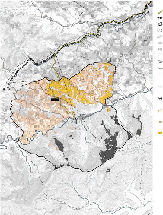
2 Negotiating with Ethno-Ecology: Landscape Management Strategies …                          169

Fig. 14 Insights drawn from two ecotourism villages in southwestern China are translated to Boten
village within the rapidly developing Boten SEZ in Laos to predict mainstream tourism planning’s
potential damages to the integrity of cultural landscapes and to devise landscape-oriented and
culture-driven means of negotiation with investors and tourism planners
170                                           7 Chinese Mass Nature Tourism and Ecotourism

Fig. 15 Calculation of tourism capacity and inevitable landscape consumption in culture tourism
2 Negotiating with Ethno-Ecology: Landscape Management Strategies …                                  171

Fig. 16 Given that salt production is a renowned local tradition and is highlighted in the current
tourism plan, it is strategically chosen here for the quantification and visualization of Boten’s cultural
territory and ideal tourism capacity
172                                              7 Chinese Mass Nature Tourism and Ecotourism

Fig. 17 Through quantification and visualization, two schemes are developed for Boten village to
negotiate with tourism developers for the protection and territorial integrity of cultural landscapes
2 Negotiating with Ethno-Ecology: Landscape Management Strategies …                       173

Fig. 18 Experiencing a highly dynamic cultural landscape characterized by complex human-nature
relationships

Fig. 19 Experiencing a landscape-oriented and culture-driven salt production system at Boten
village
174 7 Chinese Mass Nature Tourism and Ecotourism
LEGEND
Trek to Ban Nalan
a
th
am
gN
Highway
an
tion
Lu
Na al R o a d 3
to
km
Cultureshed
2
4.
Village Boundary
Nam Ha National Protected Area Contour
Rubber Plantation
Farmland
Stream
Nam Ha NPA
Ban Chalernsouk
Trek
Natural Forest
in the Cultureshed
Low-visibility Viewshed
4.6 km
of the Trek to Nalan
to th
e maj
High-visibility Viewshed
or hi
Route 1
ghway
of the Trek to Nalan
Footprint of Shifting
Cultivation
Shifting Cultivation Foodprint
in the Cultureshed but outside
Ban Nalan
the Nam Ha NPA
Shifting Cultivation Foodprint
in the Viewshed and Cultureshed
but outside the Nam Ha NPA
Fig. 20 Insights drawn from two ecotourism villages in southwestern China are translated to Nalan
village, which partially falls within the Nam Ha National Protected Area, to predict mainstream
tourism planning’s potential damages to the integrity of cultural landscapes and to devise landscape-
oriented and culture-driven means of negotiation with investors and tourism planners2 Negotiating with Ethno-Ecology: Landscape Management Strategies … 175
Scenario 1:
Annual Tourism Capacity Reaching 4380
Limited by Lodging Space
Existing daily lodging space 12
ppl
Annual tourism capacity limited by 12 * 365 = 4380
existing lodging space ppl
Village population 181
ppl Autonomous Demand of the Villagers for Tourism Expansion Negotiation for Resources from the Government
Average daily consumption of rice by 206 • Policy Compromise for Allowing Shifting Cultivation Expansion
kg/year Annual Tourism Demand of Unmilled Rice
Laotian in Luang Namtha outside the Namha NPA Exclusively for the Upland Khmu Village
Village Consumption of Rice 181 * 206 = 37286
kg/year
(4380 * 0.5 / 70%) = 3129 kg
Annual tourist Rice demand Rice milling
arrival per capita ratio
Lowest upland rain-fed rice yield 1400
kg/hactare
Rice milling ratio 70% Requirement of Rice Field Expansion for Tourism Demand
Total area of rice fields in the village
Lowest annual milled rice production 37 * 1400 * 70% =
37
ha
36260
3129 / 1400 = 2.24 ha
Tourism demand of Yield of
kg
unmilled rice Upland Rice
Annual milled rice consumption by rice wine 4370
kg Total Expansion of Shifting Cultivation Practice
Surplus of annual rice production 37286 + 4370 - 36260 = - 5396
kg
5.51 + 2.24 = 7.75 ha
Basic demand of Requirement of rice
Basic demand of rice field expansion in 5396 / 70% / 1400 = 5.51 rice field field expansion for
forested area for sustainable internal consumption ha expansion tourism demand
LEGEND
Invisible Fallow Land (10yrs)
Visible Fallow Land (5yrs)
Viewshed on the Trek
Intact Forest
Nam Ha NPA
Cutureshed
Trek to Ban Nalan
Existing Farmland
Footprint of Shifting Cultivation
Stream
Trek
Highway
Village Boundary
Fig. 21 Given that rice and rice wine production are important cultural practices for Khmu people
and are highlighted in existing ecotourism programs, they are strategically chosen here for the
quantification and visualization of Nalan’s cultural territory and ideal tourism capacity176 7 Chinese Mass Nature Tourism and Ecotourism
LEGEND
Invisible Fallow Land (10yrs)
Visible Fallow Land (5yrs)
Viewshed on the Trek
Intact Forest
Nam Ha NPA
Cutureshed
Trek to Ban Nalan
Existing Farmland
Footprint of Shifting Cultivation
Stream
Trek
Scenario 2: Highway
Annual Tourism Capacity Reaching 14300
Limited by Community Waste Disposal System Village Boundary
* Case Example of Yubeng Village, Yunnan Autonomous Demand of the Villagers for Tourism Expansion Negotiation for Resources from the Government
Population 187 Annual Tourism Demand of Unmilled Rice • Policy Compromise for Allowing Shifting
(versus 181 ppl. in Ban Nalan) ppl
Cultivation Expansion outside the Namha NPA
Exclusively for the Upland Khmu Village
Daily waste generation by tourist 0.65
kg/person (14300 * 0.5 / 70%) = 10,215 kg
Annual tourist Rice demand Rice milling • Daily lodging space expansion 28
arrival per capita ratio ppl/day
Community waste disposal capacity 9300
kg/year • Waste disposal point requirement 1
Requirement of Rice Field Expansion for Tourism Demand
Annual tourist arrival when the community waste 14300
dispocal system breaks down ppl 10215 / 1400 = 7.30 ha
Tourism demand of Yield of
unmilled rice Upland Rice
Total Expansion of Shifting Cultivation Practice
5.51 + 7.30 = 12.81 ha
Basic demand of Requirement of rice field
rice field expansion expansion for tourism demand
LEGEND
Invisible Fallow Land (10yrs)
Visible Fallow Land (5yrs)
Viewshed on the Trek
Intact Forest
Nam Ha NPA
Cutureshed
Trek to Ban Nalan
Existing Farmland
Footprint of Shifting Cultivation
Scenario 3:
Annual Tourism Capacity Reaching 23500 Stream
Limited by Maximal Labor Force
Trek
Total Village Labor force 113
ppl
Highway
Village non-field work labor requirement 34
ppl
Village Boundary
Waste disposal labor 3
ppl Autonomous Demand of the Villagers for Tourism Expansion Negotiation for Resources from the Government
Guide labor 10 Annual Tourism Demand of Unmilled Rice • Policy Compromise for Allowing Shifting Cultivation
ppl Expansion outside the Namha NPA Exclusively for
the Upland Khmu Village
Village labor surplus 34 - 3 -10 = 21
ppl
(23500 * 0.5 / 70%) = 16,786 kg
Annual tourist Rice demand Rice milling
arrival per capita ratio • Daily lodging space expansion 64
ppl/day
Minimal labor input for most intensive 1.2
season of upland rice farming ppl/ha Requirement of Rice Field Expansion for Tourism Demand • Waste disposal point requirement 2
Maximal rice field expansion
limited by labor force
21 / 1.2 = 17.5
ha
16786 / 1400 = 12.00 ha • Training of village guide 10
ppl
Tourism demand of Yield of
unmilled rice Upland Rice
Basic demand of rice field expansion in 5.51 Total Expansion of Shifting Cultivation Practice
ha
forested area for sustainable internal consumption
Tourism capacity supported by
(17.5 - 5.51) * 1400 * 70% / 0.5 = 23500 5.51 + 12.00 = 17.51 ha
maximal rice field expansion ppl Basic demand of Requirement of rice field
rice field expansion expansion for tourism demand
Fig. 22 Through quantification and visualization, three scenarios are developed for Nalan village
to negotiate with tourism developers for the protection and territorial integrity of cultural landscapes2 Negotiating with Ethno-Ecology: Landscape Management Strategies … 177
Dec Jan Feb Mar Apr May June July Aug Sep Oct Nov Dec
A jar (40liter) of rice wine will A jar of rice wine will be A jar of rice wine will be Two jars of rice wine, and Rice wine should be prepared Two jars of rice wine, a pig, At least A jar of rice wine will
be opened to notify the opened to close the seed hole opened to celebrate the two chickens, will be prepared for inviting other families to and two chickens, will be be opened for the ritual of
house-spirit with the plan of completion of planting season for the ritual of eating new participate in rice harvesting prepared for the ritual of “greh” revering the khmu’s
field selection leaves celebrating harvest completion ancestor Cheuang as the
source of all knowledge
A jar of rice wine will be
opened for the ritual
of the “start of eating new
rice”
Rice consumption of lao hai production 0.23
kg/liter
Demand of lao hai for traditional rituals 500
liter/household/year
Village demand of lao hai 19000
liter/year
Village rice consumption for lao hai 4370
kg/year
Forest for NTFP Collection
Firewood Collection from the Fallow Land
outside Nam Ha NPA for Lao Lao Production
Recover Shifting Cultivation as the
Buttress of Khmu’s Ethnic Culture
Distillation of Lao Lao (Rice Wine)
Fig. 23 Experiencing the dynamics of a shifting cultivation landscape, one of the most misunder-
stood and controversial forms of land use
Dec Jan Feb Mar April May Jun Jul Aug Sep Oct Nov Dec
Slash and Burn Planting Mid-Season Harvesting
3km
1km
500m Living in the Hut in the Field
Learn about the Slash and Burn Ecology
Trekking in the Fallow Land
Experience the Landscape of Harvestiug
Fig. 24 Experiencing a landscape-oriented and culture-driven rice and rice wine production system
at Nalan village in Laos178 7 Chinese Mass Nature Tourism and Ecotourism
3 Living Heritage: Redefining Protections for Urban
Expansion in Luang Prabang
Anticipating the boom in urbanization in Luang Prabang that follows the opening
of the China-Laos Railway, this strategic proposal foregrounds the insufficiency of
a predominantly architecture-focused cultural heritage protection mechanism insti-
tuted by UNESCO and explores the potential for a landscape-oriented framework
that defines and protects essential cultural landscapes in the region.
Situated in a valley at the confluence of the Mekong and Nam Khan rivers in north
central Laos, Luang Prabang was an ancient royal capital and the current cultural
center of the country (Reeves & Long, 2011). As Luang Prabang town experienced
increasing social and environmental pressures from the growing influx of tourists
since its designation as a UNESCO World Heritage site in 1995, the town and
its expansive landscape are currently undergoing unprecedented changes induced
by simultaneous rural–urban transformation and regional infrastructure expansion
(Figs. 25 and 26). In addition to the expected ten-fold increase in the number of
tourists visiting Luang Prabang once the China-Laos Railway begins operation at
the end of 2021,3 the pace of urbanization and deforestation is accelerating, espe-
cially along the railway. Considering the cultural significance of Luang Prabang, the
importance of forest resources to local communities and the rapid urbanization of
the region, immediate intervention is needed to protect the region’s heritage, secure
local livelihoods and curtail or redirect speculative development toward sustainable
ends.
This proposal redefines regional landscape values and reflects on the spatial impli-
cations of this valuing system. UNESCO appraises Luang Prabang as a heritage
site that “reflects the exceptional fusion of Lao traditional architecture and nine-
teenth and twentieth century European colonial style buildings” (UNESCO, 1995),
and its protection measures are spatially reflected in two boundaries defining the
core and buffer zone of the inscribed heritage property (Figs. 27 and 28). An exer-
cise combining land use and viewshed analyses in the buffer zone and along the
railway helps identify possible extents of vernacular landscapes with cultural and
ecological value. These analyses reveal contradictions embedded in the UNESCO-
delineated buffer zone. The current defined zone can abruptly exclude new capital-
driven construction along with village use of forest resources that have cultural and
livelihood significance. Consequently, this zone is not capable, either spatially or in
land use management, of regulating land conversion and speculative development of
Luang Prabang (Figs. 29 and 30) (UNESCO, 2013). Given that substantial land spec-
ulation is occurring and will expand further along the China-Laos Railway, which
passes through a dozen local villages heavily dependent on agriculture, this project
overlays predicted unregulated areas of urban expansion and viewsheds along the
railway to identify strategic spaces for intervention.
3Authors’ conversation in March 2018 with members of Luang Prabang’s network of hospitality
management.3 Living Heritage: Redefining Protections … 179
The location of new railway stations, existing highways and terrain are key factors
in predicting urban expansion areas (Fig. 31). Taking advantage of the mainstream
narrative of offering visitors an “authentic experience” of Luang Prabang’s cultural
landscape, this proposal identifies areas of urban expansion within the viewshed along
the railway that may degrade such experiences, which are regarded as crucial assets
in the tourism industry (Figs. 32, 33, 34 and 35). Guided by this spatial framework,
four multiscalar landscape strategies, namely reforestation, buffer planting, devel-
opment regulation and alternative buffer zone demarcation, are proposed to mediate
the socioenvironmental impacts of previous development projects, minimize poten-
tial spatial conflicts between the local and nonlocal use of resources, and mitigate
foreseeable land speculation (Fig. 36). In addition, three landscape typologies are
proposed to guide the spacing of new plantings and selection of plant species with
cultural and livelihood significance (Figs. 37, 38 and 39).
While UNESCO’s significant contributions to the protection of cultural heritage
across the globe are undeniable, in the context of unprecedented socioenvironmental
challenges faced by cultural heritage, such as that of Luang Prabang, a landscape
framework characterized by a three-dimensional systematic analysis of a cultural
territory is necessary, especially one shaped by cultural practices and with a critical
definition of cultural landscape heritage that is alive and dynamic.
The design proposal “Living heritage: Redefining protections for urban expan-
sion in Luang Prabang” and accompanying illustrations were developed by Haylie
Shum Hiu Lam during the course Studio Laos: Strategic Landscape Planning for the
Greater Mekong.180 7 Chinese Mass Nature Tourism and Ecotourism Fig. 25 Landscapes have always been a vital part of Lao culture. Two-fifths of Laos is forested, and the country’s forests have provided a vast variety of landscape uses, including food, agriculture, medicinal, building and spiritual uses
3 Living Heritage: Redefining Protections …                                               181

Fig. 26 Luang Prabang has experienced a growing influx of tourists since its designation as an
UNESCO World Heritage Site in 1995. The town and its extensive landscape are currently under-
going unprecedented changes induced by simultaneous rural–urban transformation and regional
infrastructure expansion
182                                         7 Chinese Mass Nature Tourism and Ecotourism

Fig. 27 Historical timeline of Luang Prabang and the current regulations managing the World
Heritage Site’s buffer zone
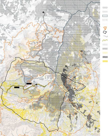
3 Living Heritage: Redefining Protections …                                             183

Fig. 28 Context map of Luang Prabang showing the boundaries of the core and buffer zones and
major challenges currently faced by the town and its landscape
184                                           7 Chinese Mass Nature Tourism and Ecotourism

Fig. 29 Land use and viewshed analyses for areas along the China-Laos Railway

Fig. 30 Land use and viewshed analyses for areas within the buffer zone
3 Living Heritage: Redefining Protections …                                                185

Fig. 31 Map showing the three phases of urban expansion, which are predicted based on proximity
to railway stations, proximity to existing highways and slope gradient
186                                           7 Chinese Mass Nature Tourism and Ecotourism

                                                                              LEGEND
                                                                              Highway
                                                                              Railway - Tunnel
                                                                              Railway - Bridge
                                                                              Railway - Station
                                                                              Buffer zone
                                                                              Protected area
                                                                              Water
                                                                              Urban expansion - 2021
                                                                              Urban expansion - 2026
                                                                              Urban expansion - 2031
                                                                              Visible extent
                                                                              Invisible extent

Fig. 32 The predicted area of urban expansion indicates a 25% increase in urban area within the
viewshed along the railway by 2031
3 Living Heritage: Redefining Protections … 187 Fig. 33 Statistics of villages affected by the predicted urban expansion. Ten villages are currently situated along the railway within the study are, encompassing 5,000 people and 638 hectares of agricultural land Fig. 34 Landscape section cut, illustrative view, and statistics of Ban Daensavang village
188                                            7 Chinese Mass Nature Tourism and Ecotourism

Fig. 35 Landscape section cut, illustrative view, and statistics of Ban Kokngiou village

Fig. 36 Four multiscale landscape strategies are proposed to mediate the socioenvironmental
impacts of previous development projects, minimize potential conflicts between local and nonlocal
use of resources and mitigate foreseeable land speculation
3 Living Heritage: Redefining Protections …                                                    189

Fig. 37 Three landscape typologies are proposed to guide the spacing of new plantings and selection
of plant species with cultural and livelihood significance
190                                           7 Chinese Mass Nature Tourism and Ecotourism

Fig. 38 Activities allowed and prohibited within the predicted area of urban expansion
3 Living Heritage: Redefining Protections …                                                    191

Fig. 39 Experiencing Luang Prabang’s cultural landscape along the China-Laos Railway

References

Architectural Design & Research Institute of SCUT. (2016). Overall conceptual planning and urban
  design for the new city of Luang Prabang. South China University of Technology (SCUT).
Ducourtieux, O., Laffort, J. R., & Sacklokham, S. (2005). Land policy and farming practices in
  Laos. Development and Change, 36(3), 499–526.
Guipu. (2016). Rural tourism guide: The most beautiful Hani Folk Village in Qingkou, Yuanyang
  County. Retrieved March 14, 2020, from https://www.guipuxcly.com/lvyougl/215.html
Hall, C. M., & Ringer, G. (2000). Tourism in Cambodia, Laos and Myanmar: From terrorism to
  tourism. In C. M. Hall, & S. Page (Eds.), Tourism in South and South East Asia: Issues and cases
  (pp. 178–194). Routledge.
Investvine. (2019). Special economic zone in Laos expects $10 billion in investments. Retrieved
  February 4, 2021, from https://investvine.com/special-economic-zone-in-laos-expects-10-bil
  lion-investments/
iSkytree Tourism Planning. (2013). Tourism planning for the Manling area of Mandan Scenic Area.
  iSkytree Tourism Planning Co., Ltd.
Kyophilavong, P., Gallup, J. L., Charoenrat, T., & Nozaki, K. (2018). Testing tourism-led growth
  hypothesis in Laos? Tourism Review, 73(2), 242–251.
Lao National Television. (2016). The government approves a Lao company to set up a special
  economic zone (SEZ) in Luang Prabang province. Retrieved February 4, 2021, from https://
  www.youtube.com/watch?v=vbFCtI-B44k
Liu, R. Q., & Ye, X. (2019). Landscape planning of mountainous villages in Yunnan under the
  background of “Beautiful Countryside”: A case study on Qingkou Hani Folk Village, Honghe
  Prefecture. Development of Small Cities & Towns, 37(5), 100–108.
Planning and Design Center of Haicheng Group. (2018). Overall planning and urban design for
  the Boten Special Economic Zone (2018–2030). Yunnan Haicheng Industry Group Co., Ltd.
Prado, H. M., & Murrieta, R. S. S. (2015). Ethnoecology in perspective: The origins, interfaces and
  current trends of a growing field. Ambiente & Sociedade, 18(4), 139–160.
Reeves, K., & Long, C. (2011). Unbearable pressures on paradise? Tourism and heritage
  management in Luang Prabang, a World Heritage Site. Critical Asian Studies, 43(1), 3–22.
Salazar, N. B. (2009). Imaged or imagined? Cultural representations and the “tourismification” of
  peoples and places. Cahiers d’Études Africaines, 49(193–194), 49–71.
192                                             7 Chinese Mass Nature Tourism and Ecotourism

Sina. (2015). Detailed tourism planning for the Manling area of Mandan Scenic Area, Xishuang-
  banna. Retrieved March 10, 2020, from http://blog.sina.com.cn/s/blog_14a36a8e70102vueg.
  html
State Council of the People’s Republic of China. (2000). Circular of the state council concerning
  several policies on carrying out the development of China’s Vast Western Regions. Retrieved
  February 1, 2021, from http://www.gov.cn/gongbao/content/2001/content_60854.htm
Ta Kung Pao. (2019). Boten special economic zone attracts investors’ attention. Retrieved February
  4, 2021, from http://www.takungpao.com/special/239159/2019/0611/301822.html
Travers, R. (2008). Economic corridors and ecotourism: Whither tourism in Laos? In Asian tourism:
  Growth and change (pp. 105–116). Elsevier.
UNESCO. (1995). Town of Luang Prabang. Retrieved April 10, 2018, from https://whc.unesco.org/
  en/list/479/
UNESCO. (2013). Town of Luang Prabang—Maps of the inscribed property—minor boundary
  modification. Retrieved April 10, 2018, from https://whc.unesco.org/en/list/479/multiple=1&uni
  que_number=1954
Zinda, J. A. (2014). Making National Parks in Yunnan: Shift and struggles within the ecological
  state. In E. T. Yeh, & C. R. Coggins (Eds.), Mapping Shangrila: Contested landscapes in the
  Sino-Tibetan borderlands (pp. 105–128). University of Washington Press.

Open Access This chapter is licensed under the terms of the Creative Commons Attribution 4.0
International License (http://creativecommons.org/licenses/by/4.0/), which permits use, sharing,
adaptation, distribution and reproduction in any medium or format, as long as you give appropriate
credit to the original author(s) and the source, provide a link to the Creative Commons license and
indicate if changes were made.
    The images or other third party material in this chapter are included in the chapter’s Creative
Commons license, unless indicated otherwise in a credit line to the material. If material is not
included in the chapter’s Creative Commons license and your intended use is not permitted by
statutory regulation or exceeds the permitted use, you will need to obtain permission directly from
the copyright holder.
You can also read


